
2014 LGPS Proposals Fire Brigades Union 2014 LGPS proposals.

Request for Proposal –Establishment of State Spatial Data Infrastructure (J&K State Geo-portal)
1
REQUEST FOR PROPOSALS
For
Selection of Total Solution Provider
For
Establishment of State Spatial Data Infrastructure (J&K State Geo-portal)
(The quotes have to be submitted on or before 22-07-2015 at 16.00 hrs.)
Tender Document No:-____________________________ Dated: ____________
TSP Ref No: ______________
Government of Jammu & Kashmir Department of Ecology, Ecology, Environment & Remote Sensing,
SDA Colony, Bemina, Srinagar, Kashmir-190018 Email : [email protected]
Request for Proposal –Establishment of State Spatial Data Infrastructure (J&K State Geo-portal)
2
Tender Notice
The Department of Ecology, Environment & Remote Sensing, Government of Jammu & Kashmir
seeks services of a qualified Geo-spatial consultant / Total Solution Provider for establishment of J&K
State Spatial Data Infrastructure (J&K State Geo-portal) with state of art geospatial lab facility with
SSDI infrastructure, on a Turn-Key basis which would include supply of requisite hardware, software,
Software customization, installation, development, operationalization and maintenance.
Accordingly, the Department of Ecology, Environment & Remote Sensing now invites Total Solution
Providers (TSPs) to submit bids in accordance with the Request for Proposal (RFP). The RFP
document containing full details of the assignment and technical requirements, along with terms
and conditions, can be downloaded from the official website of the Department of Ecology,
Environment & Remote Sensing, J&K Government (http://www.jkdears.com). Applicants obtaining
the document from departmental website shall deposit a non-refundable Demand Draft of INR
5000/- (Rupees five thousand only) drawn in favour of Director, Ecology, Environment & Remote
Sensing, J&K Govt. towards cost of the RFP document, payable at Srinagar, along with the bid
document. The amount paid towards cost of RFP document is non-refundable.
Last date for submitting the document is up to 16:00 hours on 22nd of July, 2015
Addl.PCCF/Director, Department of Ecology, Environment & Remote Sensing,
J&K Government, SDA Housing Colony, Bemina, Srinagar, Kashmir, J&K State, India
Phone/Fax: 0194-2490823 e-mail :[email protected]

Request for Proposal –Establishment of State Spatial Data Infrastructure (J&K State Geo-portal)
3
CONTENTS
SECTION 1 LETTER OF INVITATION
SECTION 2 INFORMATION TO TOTAL SOLUTION PROVIDERS
SECTION 3 STANDARD FORMS
SECTION 4 TERMS OF REFERENCE
SECTION 5: CONFIGURATION FOR REQUIRED HARDWARE/SOFTWARE ITEMS
SECTION 6: CUSTOMIZATION OF DATA, SOFTWARE AND DEVELOPMENT OF GEO PORTAL
SECTION 7: STANDARD FORM OF CONTRACT
Appendices to be provided by TSP
Request for Proposal –Establishment of State Spatial Data Infrastructure (J&K State Geo-portal)
4
SECTION 1: LETTER OF INVITATION
To
M/s…………………………………………..
……………………………………………………………
……………………………………………………………….
Dear Sir / Madam,
Sub: Letter of Invitation for establishment of a Geo-portal - State Spatial Data
Infrastructure.
.
1. The State Spatial Data Infrastructure(J&K State Geoportal) is being established to create infrastructure for availability of and access to organized spatial data and use of the infrastructure at Community, Local, State, Regional and at National levels.
2. The Department of Ecology, Environment & Remote Sensing (DEARS) intends to establish the following facilities:
a. Conversion of both spatial and non-spatial properties of geographical features in an open standard GML format to serve as a modeling language for geographic systems as well as for geographic transactions on the Internet.
b. Develop a Geo-portal to support OGC-compliant web services with advanced geo-processing capabilities for local level planning in J&K State. The Department of Ecology, Environment & Remote Sensing (DEARS) releases this request to solicit proposals from qualified and experienced Total Solution Providers (TSPs) for setting up the Geo-portal.
3. Towards achieving the above vision, the DEARS now invites sealed proposals (both technical and financial) in accordance with the Request for Proposal (RFP) from TSP(s) having proven track record to provide end to end solution in geospatial services with specific reference to system design, GML data conversion, system integration, software development, projects of similar nature, which include supply of hardware/software, software development, customization of data/software, installation, Geoportal development, its operationalization and maintenance (refer eligibility criteria in section 2 para 24).
4. In support of the above requirement, the TSP is primarily expected to customize, install, demonstrate and operationalize relevant hardware, software and data for geo-portal, access to and maintenance of the underlying master database by uploading data from remote clients available with the data generating / survey agencies.
5. The servers and storage of SSDI-JK is proposed to be housed ultimately in a building to be constructed in the campus of the Department of Ecology, Environment & Remote Sensing situated at Bemina, Srinagar, Kashmir. However, till the new construction comes up in the campus, the TSP shall have to operationalize the Geo-portal in the existing building and once the new accommodation becomes available, the TSP shall have to reinstall the hardware/software in the new facility without claiming extra charges. Provided further, the

Request for Proposal –Establishment of State Spatial Data Infrastructure (J&K State Geo-portal)
5
facilities of power supply, internet connectivity and working space shall be provided by the Department for the purpose in the existing building and later in the newly constructed accommodation for SSDI-JK.
6. The TSP is expected to submit separate technical and financial proposal. The technical bid will be opened first. Qualified TSPs will be short-listed based on soundness of the technical proposal, completeness, and suitability of the proposed architecture, technical competency and financial status. The financial bids of the short listed TSPs only will be opened for final selection. Financial bids of more than 25% over and above the estimated cost of approximately Rs 200 lacs, shall be considered as unreasonable and therefore, liable to be rejected forthwith.
7. The RFP document containing full details of the assignment, technical requirements, terms of reference, scope of work, formats for Technical and Financial proposal along with other details can be downloaded from the official website of the Department of Ecology, Environment & Remote Sensing, J&K Government (http://www.jkdears.com). Applicants obtaining the document from departmental website shall deposit a Demand Draft of INR 5000/- (Rupees five thousand only) drawn in favour of Director, Ecology, Environment & Remote Sensing, J&K Govt. towards cost of the RFP document, payable at Srinagar, along with bid document without which the bid document shall be rejected. The amount paid towards cost of RFP document is non-refundable.
8. An Earnest Money Deposit (EMD) of Rs.5 lakhs (Rupees five Lakhs only), in the form of Demand Draft drawn in favor of the Director, Department of Ecology, Environment & Remote Sensing, J&K payable at Srinagar must be submitted along with the Proposal. Proposals not accompanied by EMD shall be summarily rejected as non-responsive. No interest shall be payable by the DEARS for the sum deposited as earnest money deposit. Bank guarantee /cheques will not be accepted in lieu of the EMD. The EMD of the unsuccessful TSPs would be returned back within one month of signing of the contract with successful TSP, whichever is later.
9. DEARS shall not be responsible for any postal delays in receipt of the tender submitted by the TSP. Documents received through FAX and e-mail shall not be acceptable or considered in this Department.
10. Two copies of Technical Proposal with detailed project implementation plan (as per the ToR) and Financial Proposal should be submitted. The TSP shall seal the EMD, Technical Proposal and Financial Proposal in separate envelopes marked EMD, Technical Proposal and Financial Proposal respectively. All the three envelopes should be sealed in a single envelope and addressed to the Director, Department of Ecology, Environment & Remote Sensing, J&K Govt., Srinagar with the wrapper clearly marked “PROPOSAL FOR J&K STATE SPATIAL DATA INFRASTRUCTURE-GEOPORTAL”.
11. A TSP will be selected based on the evaluation procedure as outlined in the Section 2,
para15. 12. Last date for submitting the document is 22-07-2015.The interested parties can visit the
Department of Ecology, Environment & Remote Sensing, J&K Govt., Bemina, Srinagar for site inspection on any working day between 11.00 hrs. to 16.00 hrs, under intimation to this office well in advance. The complete application in the required format incorporating all the requirements in the RFP document should be submitted latest by 16:00 Hrs. on 22-07-2015 in the office of Director, Department of Ecology, Environment & Remote Sensing, DEARS Office complex, SDA Colony, Bemina, Srinagar, Kashmir(J&K)-190018.
13. Applicants having a turnover of Rs 1 crore in the last financial year with consolidated turnover of Rs 3 crores for the last three financial years from development of WebGIS & Geospatial system integration (GIS related Hardware/Software sales & services) shall be preferred.
14. The hardware and software items proposed in the RFP are to be supplied as per specifications indicated in the RFP document. However, in case a particular hardware or software item with

Request for Proposal –Establishment of State Spatial Data Infrastructure (J&K State Geo-portal)
6
indicated specification in the RFP document is not available in the market at the time of supply, then the TSP can supply its equivalent or higher configuration /version of industry standard brands with prior approval of the Department, to ensure hassle-free functioning of the Geoportal.
15. In order to help use and manage/ maintain the complete system, TSP should provide support for three years from the date of commencement of operationalization of the geoportal.
16. The TSP quoting for the services should be a total solution provider and that support to be but in a comprehensive manner by ensuring total responsibility of the systems and providing updates for the software as per the agreement as and when released.
17. 10 core staff of SSDI-JK should be provided hands-on training of minimum 15 working days duration on the functioning, operation and maintenance of the equipment and provision of services.
18. After completion of the project and the warranty period, it should be possible for the core staff to maintain the system on their own with minimal support from the TSP as per the terms and conditions of the warranty and maintenance agreement.
19. As is required under the SSDI-JK Project, the geo-portal will be regularly upgraded to help data/ service providers publish their metadata/ data/ services for access by the clients over the web. On the completion of the project, the set up will be run and maintained by the Department of Ecology, Environment & Remote Sensing.
20. The selected solution provider awarded the Contract should execute an agreement on stamp paper worth Rs.100/- and shall also be responsible for on-site warranty for 1 year and call based support for next two years for hardware, software and the customized geoportal system from the date of successful acceptance and operationalization of the solution.
21. Security Deposit: Within 10 days after receipt of the Letter of Acceptance, the successful TSP will have to furnish along with the agreement a security deposit @ 2 % of the value of the Contract or Rs.5.0 lakhs whichever is higher, in the form of a Bank Guarantee on any Nationalized Bank (in favor of Director, Department of Ecology, Environment & Remote Sensing) valid for 12 months from the date of letter of acceptance with a provision of its further extension/ revalidation up to the period of two years. The requisite Performa for the Bank Guarantee is given in Appendix-F.
22. The TSPs are requested to visit the premises of the Department of Ecology, Environment & Remote Sensing, Bemina, Srinagar on any working day between 11:00 hrs and 15:00 hrs, under intimation to the Director Department of Ecology, Environment & Remote Sensing on his email id at [email protected]. Further, once the new building of SSDI-JK comes up in the campus of the DEARS at Bemina, the TSP shall have to reinstall the equipment and fully re-operationalize the Geoportal in the new premises. The new accommodation is expected to be ready within the next two years.
23. The RFP includes the following documents. Section 1 - Letter of Invitation; Section 2 - Information to TSPs
Section 3 - Standard Forms required for consideration of the RFP
Section 4 -Terms of Reference;
Section 5 - Configuration of Required equipment, Hardware/software items;
Section 6 - Customization of data, software and development of applications for Users;
Section 7 - Standard Form of Contract.
Please inform us, upon receipt:
(a) That you have received the letter of invitation; and

Request for Proposal –Establishment of State Spatial Data Infrastructure (J&K State Geo-portal)
7
(b) Whether you will submit a proposal alone or in association.
The complete bid document shall only be available on the web site of the Department
www.jkdears.com and can be downloaded by the TSP. A non- refundable fee in the form of demand
draft for INR 5000 drawn in favour of the Director, Department of Ecology, Environment & Remote
Sensing, J&K, has to be submitted along with bid document in a separate envelope subscribed as, ‘
Tender document fee’. The amount paid towards cost of RFP document is non-refundable.
Kindly respond to the RFP as per directions and formats provided in the RFP.
The Director, Department of Ecology, Environment & Remote Sensing, J&K Govt. reserves the
right to reject any or all the bids in whole or in part at any time without assigning any reason
thereof.
Yours Sincerely,
Addl. PCCF/Director Department of Ecology, Environment & Remote Sensing,
J&K Govt., Bemina, Srinagar, Kashmir
Email : [email protected]

Request for Proposal –Establishment of State Spatial Data Infrastructure (J&K State Geo-portal)
8
SECTION 2
INFORMATION TO TOTAL SOLUTION PROVIDERS
1.0 DEFINITIONS
DEARS means the Department of Ecology, Environment & Remote Sensing,
Government of Jammu & Kashmir, who have invited the bids for services, and with
which the selected TSP signs the Contract for the Services and to which the selected
TSP shall provide services as per the terms and conditions and Terms of Reference
(ToR) of the contract or any other institution/bodies/department as assigned by the
DEARS.
TSP means any Company/firm/proprietor continuously engaged in the field of Geo-
spatial Technologies which submit its proposals that may provide or provides the
Services to the DEARS under the Contract.
Contract means the Contract signed by the parties and all the attached documents
listed in its RFP and appendices.
Project specific information means such part of the Instructions to TSP used to
reflect specific project and assignment conditions.
Day means calendar day.
Government means the Government of Jammu & Kashmir
Proposal means the technical proposal and the financial proposal.
RFP means the Request For Proposal prepared by the DEARS for selection of TSP.
Assignment / job mean the work to be performed by the TSP pursuant to the
Contract
Sub-TSP means any Company/firm/proprietor or entity with which the TSP sub-
contracts any part of the assignment/job.
Terms of Reference (ToR)
means the document included in the RFP which explains the objectives, scope of
work, methodology, activity schedule, and tasks to be performed, respective
responsibilities of the DEARS and the TSP, and expected results and deliverables of
the assignment/job etc.
AMC means Annual Maintenance Contract.
SC Service contract
EMD Earnest Money Deposit
ICT Inter communication Technologies

Request for Proposal –Establishment of State Spatial Data Infrastructure (J&K State Geo-portal)
9
2. INTRODUCTION
2.1 Procurement of Bid Document
The complete bid document can be downloaded from the official website of the Department of
Ecology, Environment & Remote Sensing, J&K Government (http://www.jkdears.com). Applicants
obtaining the document from departmental website shall deposit a Demand Draft of INR 5000/-
(Rupees five thousand only) drawn in favour of Director, Ecology, Environment & Remote Sensing,
J&K Govt. towards cost of the RFP document, payable at Srinagar, along with bid document in a
separate envelope subscribed as, ‘ Tender document fee’. The amount paid towards cost of RFP
document is non-refundable. Bids not accompanied by non-refundable fee in the form of
demand draft for INR 5000/ drawn in favour of the Director, Department of Ecology,
Environment & Remote Sensing, Jammu & Kashmir State, shall be rejected.
In case of any clarification with regard to the bid document, the TSPs may get in touch with
the contact person as mentioned in the data sheet (Section 2 para 24). However, the
bidders are encouraged to undertake a preliminary study of the project, at their own cost
before they submit their bids.
2.2 Detailed scope of the work/ has been described in the Terms of Reference in section 4.
2.3 The date, time and address for submission of the proposals have been given in the data
sheet (Section 2 Para 24).
2.4 The TSPs are invited to submit technical proposal and a financial proposal, as specified in
the data sheet (Section 2 Para 24) for system integrating services required for the
assignment named in the data sheet (Section 2 Para 24). The proposal will be the basis for
Contract negotiations and ultimately for a signed Contract with the selected TSP.
2.5 The Employer named in the data sheet (Section 2 Para 24) will select TSP in accordance
with the method of selection specified in the section 2 para 15.
2.6 The date, time and address for submission of the proposals have been given in data
sheet (Section 2 Para 24).
2.7 TSP(s) should familiarize themselves with local conditions and take them into account in
preparing their proposals. To obtain first-hand information on the assignment and local
conditions, TSP(s) are encouraged to visit the DEARS before submitting a proposal.
2.8 DEARS will timely provide, at no cost, to the TSP(s) the inputs and facilities specified in
the data sheet (Section 2 Para 24) and assist them in carrying out the services, and make
available relevant support, data and reports.
2.9 The TSP(s) shall bear all the costs associated with their visit to the employer, preparation
and submission of their proposals and contract negotiation. The DEARS is not bound to
accept any proposal, and reserves the right to annul the selection process at any time prior
to contract award, without thereby incurring any liability to the TSP(s).

Request for Proposal –Establishment of State Spatial Data Infrastructure (J&K State Geo-portal)
10
2.10 DEARS requires that all TSP(s) participating in consulting assignments to adhere to the
highest ethical standards, both, during the selection process and throughout the execution
of the Contract. In pursuance of this policy, DEARS;
(a) Defines, for the purpose of this paragraph, the terms set forth below as follows:
(i) Corrupt practice means the offering, giving, receiving, or soliciting, directly or
indirectly, of anything of value to influence the action of a DEARS official in the
selection process or in Contract execution;
(ii) Fraudulent practice means a misrepresentation or omission of facts in order to
influence a selection process or the execution of a Contract;
(iii) Collusive practices means a scheme or arrangement between two or more TSP(s)
with or without the knowledge of the DEARS designed to establish prices at artificial,
non-competitive levels;
(iv) Coercive practices means harming or threatening to harm, directly or indirectly,
persons or their property to influence their participation in a procurement process,
or affect the execution of a Contract.
(b) Will reject a proposal for award if it determines that the TSP recommended for award
has, directly or through an agent, engaged in corrupt, fraudulent, collusive or coercive
practices in executing the Contract in question;
(c) Will impose sanction on a TSP, including declaring the TSP ineligible, either indefinitely or
for a stated period of time, to be awarded by DEARS if at any time determines that the TSP
has, directly or through an agent, engaged in corrupt, fraudulent, collusive or coercive
practices in competing for, or in executing, DEARS Contract; and
(d) Will have the right to require that, in Contracts of DEARS, a provision be included,
requiring TSP(s) to permit the DEARS to inspect their accounts and records and other
documents relating to the submission of proposals and Contract performance.
2.11 No TSP, its Sub-TSP(s), or associate(s) shall be under a declaration of ineligibility for
corrupt and fraudulent practices issued by the DEARS in accordance with the above Para.
2.12 Goods supplied and consulting services provided under the Contract may originate
from any country except if:
(i) As a matter of law or official regulation, the beneficiary’s country prohibits
commercial relations with that country; or
(ii) By an act of compliance with a decision of the United Nations Security Council
taken under Chapter VII of the Charter of the United Nations, the beneficiary’s

Request for Proposal –Establishment of State Spatial Data Infrastructure (J&K State Geo-portal)
11
Country prohibits any imports of goods from that country or any payments to
persons or entities in that country.
2.13 Project Management: The TSP is requested to provide a project management plan
considering the following:
i. The TSP should follow industry standard practices for project management.
ii. Software development, life cycle proposed to be adopted by the TSP shall follow
proven software engineering standards.
iii. The TSP shall also constitute a project team on time and as per the scheduled
agreed upon. All activities necessary for the project will be initiated and planned well
in advance by the TSP in consultation with DEARS.
iv. The product should be developed, tested and quality checked by the TSP at his
own site before deploying at the DEARS.
2.14 The Employer named in the data sheet (Section 2 Para 24) will select TSP in accordance
with the method of selection specified in the data sheet.
3.0 ELIGIBILITY OF ASSOCIATION OF TSP AND SUB-TSPs
1. A bidding firm may be a corporation/company or consortium of companies/ corporations.
Consortium shall mean more than one company with complementing skills joining together
to undertake the scope of the work defined in this RFP.
2. In case of consortium applicant, consortia shall submit a valid memorandum of
association (MOU) agreement among the members signed by the authorized signatories of
the companies dated prior to the submission of the bid.
3. If the TSP had formed an association, each member of the association shall be evaluated
as per the qualification/eligibility criteria set forth in data sheet (Section 2 Para 24). The
combined score of the each member of the association of TSP shall be taken into account
for evaluation purpose.
4. The MOU shall specify the prime bidder, stake of each member and outline the roles and
responsibilities of each member. The MOU shall be exclusively for this project and should
confirm that each member of the consortium is liable jointly and severally for execution of
the contract.
5. The bidder and consortium companies must be a Company registered under Indian
Companies Act 1956 or Companies registered under Indian Partnership Act at least since last
three years.
6. In the event of consortium, one of the partners shall be designated as “Prime Bidder”.
The bidder (prime) shall be an Information Technology Company/ IT System integrate. Each

Request for Proposal –Establishment of State Spatial Data Infrastructure (J&K State Geo-portal)
12
member of the consortium shall be equally responsible jointly and severally for execution of
the contract.
7. In consortium, all the members are equally responsible, to complete the project.
However, Prime bidder shall give an undertaking for successful completion of the project. In
case of any issues, prime bidder would be responsible for all the penalties.
8. A bidding company/ consortium cannot be part of more than one consortium. Any
member of consortium cannot bid separately as a sole bidder. The bidder (all consortium
partners) must have company registration certificate, valid VAT/sales tax registration
certificate, valid Service Tax registration Certificate and Income Tax return with Audit report
from CA. Bidder shall provide an attested copy of all the above certificates along with this
document.
4.0 CLARIFICATION AND AMENDMENT OF RFP DOCUMENTS TSP(s) may request clarification of any aspect of the RFP documents up to the number of days indicated in the data sheet (Section 2 Para 24) before the proposal submission date. Any request for clarification must be sent in writing or by standard electronic means to the DEARS, address indicated in the data sheet (Section 2 Para 24). The DEARS will respond by standard electronic means( email/Departmental website) (including an explanation of the query but without identifying the source of inquiry) to all TSP(s). The DEARS deem it necessary to amend the RFP as a result of a clarification.
At any time before the submission of proposals, the DEARS may amend the RFP by issuing an addendum in writing or by standard electronic means. The addendum shall be published on departmental website and will be binding on them. To give TSP(s) reasonable time in which to take an amendment into account in their proposals, DEARS may, if the amendment is substantial, extend the deadline for the submission of proposals.
5.0. CONFLICT OF INTEREST
5.1. The Employer requires that TSP should provide professional and impartial advice and at all times hold the Employer’s interests paramount, strictly avoid conflicts with other assignment/jobs or their own corporate interests and act without any consideration for future work. 5.2. Without limitation on the generality of the foregoing, TSP, and any of their affiliates, shall be considered to have a conflict of interest and shall not be recruited, under any of the circumstances set forth below:
(i) Conflicting assignment/job: A TSP (including its Personnel and Sub-TSP) or any of its affiliates shall not be hired for any assignment/job that, by its nature, may be in conflict with another assignment/job of the TSP to be executed for the same or for another Employer. For example, a TSP hired to prepare engineering design for an infrastructure project shall not be engaged to prepare an independent environmental assessment for the same project, and a TSP assisting an Employer in the privatization of public assets shall not purchase, nor advice purchasers of, such assets.

Request for Proposal –Establishment of State Spatial Data Infrastructure (J&K State Geo-portal)
13
(ii) Conflicting relationships: A TSP (including its Personnel and Sub-TSP) that has a business relationship with a member of the Employer’s staff who is directly or indirectly involved in any part of (i) the preparation of the Terms of Reference of the assignment/job, (ii) the selection process for such assignment/job, or (iii) supervision of the Contract, may not be awarded a Contract, unless the conflict stemming from this relationship has been resolved in a manner acceptable to the Employer throughout the selection process and the execution of the Contract.
5.3 TSP have an obligation to disclose any situation of actual or potential conflict that
impacts their capacity to serve the best interest of their Employer, or that may
reasonably be perceived as having this effect. Any such disclosure shall be made as
per the standard forms of technical proposal provided herewith. If the TSP fails to
disclose said situations and if the Employer comes to know about any such situation
at any time, it may lead to the disqualification of the TSP during bidding process or
the termination of its Contract during execution of assignment.
6. 0 UNFAIR ADVANTAGE
If a TSP could derive a competitive advantage from having provided consulting
assignment/job related to the assignment/job in question and which is not defined as
conflict of interest as per para 5 above, the Employer shall make available to all TSP
together with this RFP all information that would in that respect give such TSP any
competitive advantage over competing TSP.
7. 0 PROPOSAL
Only one proposal should be submitted by a TSP. If a TSP submits or participates in more
than one proposal, such proposals shall be disqualified.
8.0 PROPOSAL VALIDITY
The data sheet (Section 2 Para 24) indicates how long the proposals must remain valid after
the submission date. During this period, TSP shall maintain the availability of professional
staff nominated in the proposal and also the financial proposal unchanged. The Employer
will make its best effort to complete negotiations within this period. Should the need arise,
the Employer may request TSP to extend the validity period of their proposals. TSP who
agrees to such extension shall confirm that they maintain the availability of the professional
staff nominated in the proposal and their financial proposal remain unchanged, or in their
confirmation of extension of validity of the proposal, TSP could submit new staff in
replacement, which would be considered in the final evaluation for contract award. TSP who
do not agree have the right to refuse to extend the validity of their proposals.
9. PREPARATION OF PROPOSAL
9.1 The proposal as well as all related correspondence exchanged by the TSP and the Employer shall be written in English language.

Request for Proposal –Establishment of State Spatial Data Infrastructure (J&K State Geo-portal)
14
9.2 In preparing their technical proposal, the TSP(s) are expected to examine the documents constituting this RFP in detail. Material deficiencies in providing the information requested may result in rejection of a proposal. 9.3 While preparing the technical proposal, TSP(s) must give particular attention to the following:
(a) If the TSP considers that it may enhance its expertise for the assignment by associating with other TSP(s) in a joint venture or sub-consultancy, it may associate with other TSP(s). The short listed TSP shall act as association leader. In case of a joint venture, all partners shall be jointly and severally liable and shall indicate who will act as the partner in charge of the joint venture. (b) The estimated number of professional staff-months for executing the assignment shall be shown in the data sheet (Section 2 Para 24). However, the proposal shall be based on the number of professional staff-months or budget estimated by the TSP(s). (c) Alternative professional staff shall not be proposed and only one curriculum vitae (CV) may be submitted for each position. (d) Documents to be submitted by the TSP(s) as part of this assignment must be in English. 9.1 Technical Proposal Format and Content:
TSP(s) are required to submit full technical proposal. The data sheet (Section 2 Para 24)
indicates the format of the technical proposal to be submitted. Submission of the wrong
type of technical proposal will result in the proposal being deemed non-responsive. The
technical proposal shall provide the following information indicated in the following para
from (a) to (h) using the attached standard forms (section 3).
(a) Description of the TSP(s)’ organization and an outline of recent experience of the TSP(s) and, in the case of joint venture, for each partner, on assignments of a similar nature are required. For each assignment, the outline should indicate the names of sub-TSP(s)/ professional staff who participated, duration of the assignment, contract amount, and TSP’s involvement. Information should be provided only for those assignments for which the TSP was legally contracted by the Employer or as one of the major TSP(s) within a joint venture. Assignments completed by individual professional staff working privately or through other consulting TSP(s) cannot be claimed as the experience of the TSP, or that of the TSP’s associates, but can be claimed by the professional staff themselves in their CVs. TSP(s) should be prepared to substantiate the claimed experience if so requested by the DEARS. (b) A description of work plan for performing the assignment covering the following subjects, viz., technical approach and methodology, work plan, and organization and staffing schedule. Broad guidelines on content of this section of the technical proposals are provided in Section 4. The work plan should be consistent with time schedule for professional personnel and the work (activity) schedule which will show in the form of a bar chart the timing proposed for each professional staff/ activity. (c) Description of the approach, methodology and work plan should include charts, diagrams, and comments and suggestions, if any, on terms of reference and counterpart staff and facilities.

Request for Proposal –Establishment of State Spatial Data Infrastructure (J&K State Geo-portal)
15
(d) The list of proposed professional staff team by area of expertise, the position that would be assigned to each staff team member, and their tasks. (e) Estimates of the staff input in terms of staff-months needed to carry out the assignment. The staff-months input should be indicated separately for home office and field activities, and for foreign and local professional staff. (f) CVs of the professional staff signed by the staff themselves or by the authorized representative of the Professional Staff. (g) Detailed description of the proposed methodology and staffing for training. (h)The technical proposal shall not include any financial information. Technical proposals containing financial information may be declared non-responsive. (i) The proposal should clearly give proof of local office/tie up of the TSP in Srinagar or in the absence of its local office/Service Centre in Srinagar, or it should give proof of its local competent collaborator /Sub-TSP in Srinagar. (j)The RFP should provide the specifications of the Hardware and software to be installed.
9.2. Financial Proposal
The financial proposal shall be prepared using the attached standard forms (Section 3). It
shall list all costs associated with the assignment. If appropriate, these costs should be
broken down by activity and, local expenditures. Activities and items described in the
technical proposal but not priced separately in the summary of costs, shall be assumed to be
included in the prices of other activities or items.
10. TAXES
The TSP may be subject to local taxes (such as: value added or sales tax, service tax or
income taxes, VAT etc, fees, levies) on amounts payable by the DEARS under the Contract.
The financial proposal should include the statutory taxes and the final figure shall be all
inclusive.
11. CURRENCY
TSP shall express the price of their assignment/job in India Rupees only (INR).
Prices/quotations in currencies other than INR shall be summarily rejected.
12. SUBMISSION AND RECEIPT OF PROPOSALS
Only one proposal should be submitted by a TSP. If a TSP submits or participates in more than one proposal, such proposals shall be disqualified.
i) The original proposal (technical and financial) shall contain no interlineations or overwriting. Submission letters for both technical and financial proposals should respectively be in the format of Section 3.
ii) An authorized representative of the TSP(s) shall sign all pages of the original technical and financial proposals. The authorization shall be in the form of a written Power of Attorney accompanying the proposal or in any other form demonstrating that the representative has been duly authorized to sign. The

Request for Proposal –Establishment of State Spatial Data Infrastructure (J&K State Geo-portal)
16
signed technical and financial proposals shall be marked ORIGINAL or COPY as appropriate.
iii) The technical proposals shall be sent to the addresses referred to in the data sheet and in the number of copies indicated in the data sheet (Section 2 para 24). All required copies of the technical proposal are to be made from the original. If there are discrepancies between the original and the copies of the technical proposal, the original governs.
iv) DEARS shall not be responsible for any postal delays in receipt of the RFP document. Documents received through FAX and e-mail etc. shall not be acceptable or considered in this Department.
v) The original and all copies of the technical and financial proposal shall be placed in a sealed envelope clearly marked TECHNICAL PROPOSAL and FINANCIAL PROPOSAL respectively and shall be placed, along with sealed envelope containing EMD of Rs 5,00,000/- (Five Lakhs only) and another sealed envelope containing non-refundable RFP fee of Rs 5000/= ( five thousand only)in the form of Demand Draft favouring Director, Department of Ecology, Environment & Remote Sensing(DEARS), Srinagar/Jammu, J&K payable at Srinagar in a sealed envelope with the number of the tender document and name of the assignment marked. The amount paid towards cost of RFP document is non-refundable. The envelopes containing the technical, financial proposals, EMD and RFP document fee shall be placed into an outer envelope and sealed and addressed to the Director, Department of Ecology, Environment & Remote Sensing(DEARS), SDA Housing Colony, Bemina, Srinagar, Kashmir-190018 (India) and the wrapper clearly be marked PROPOSAL FOR SSDI-JK - GEOPORTAL . This outer envelope shall bear the submission address, reference number and title of the assignment, and be clearly marked DO NOT OPEN, EXCEPT IN THE PRESENCE OF THE OFFICIAL APPOINTED. DEARS shall not be responsible for misplacement, losing or premature opening if the outer envelope is not sealed and/or marked as stipulated.
i) This circumstance may be cause for rejection of the proposal. If the financial proposal is not submitted in separate sealed envelopes duly marked as indicated above, this will constitute grounds for declaring the proposal non-responsive.
ii) An Earnest Money Deposit (EMD) of Rs. 5 lakhs (Rupees five Lakhs) only in the form of DD drawn in favor of the Director, Department of Ecology, Environment & Remote Sensing, J&K and payable at Srinagar, must be submitted along with the Proposal. Proposals not accompanied by EMD shall be rejected as non-responsive. No interest shall be payable by the DEARS for the sum deposited as earnest money deposit. Bank guarantee/cheque will not be accepted in lieu of the EMD. The EMD of the unsuccessful TSPs would be returned back within one month or signing of the contract with successful TSP, whichever is later.
iii) The proposals must be sent to the address/addresses indicated in data sheet and received by the DEARS no later than the time and the date indicated in the data sheet (Section 2 para 24). Any proposal received by the DEARS after the deadline for submission will be returned unopened.
13. ELIGIBILITY CRITERIA

Request for Proposal –Establishment of State Spatial Data Infrastructure (J&K State Geo-portal)
17
The TSP should have the capability to implement projects/assignments in terms of industry
experience, requisite manpower of required qualification and experience, project
management skills and quality/level of work. The TSP should have reasonable long-standing
current operational agreement with the suppliers till the completion of the project as well
as active and passive component manufacturers, which they are proposing.
14. TSPs GENERAL QUALIFICATIONS
Firm/Company/ concern who has been banned by the Central/State Government
Departments/ DGS&D to do business with government departments will be ineligible to
participate.
The TSP must fulfill the following eligibility conditions and furnish evidence of each:
i. The bidding firm/company must be a registered company under Indian Companies Act,
1956/Registrar of firms or Companies under Indian Partnership Act and must be
Capable of providing turnkey solutions (provide documentary proof).
ii. The TSP must have adequate experience in designing, developing and implementing
projects in the field of IT, establishment of data centers/ Remote Sensing & GIS/
development of Web GIS application / web-based major GIS projects/ development and
deployment of geo portals in India and or overseas.
iii. TSP should have at least 10 permanent Technical Skilled Persons working for GIS/RS activities. Of which, minimum of 03 staff should be involved in the development of SDI or WEB GIS application. Necessary proof should be attached.
iv. TSP should have experience of having completed minimum of one projects involving SDI portal development or WEB GIS application development. This fact should be substantiated with proof to be attached with the technical bid document.
v. TSP should have completed at least one SDI or WEB GIS project for any government or semi-government organization at national or state level.
vi. TSP should have one of the SDI or WEB GIS projects completed using OGC compliant web services such as WMS, WFS, WCS, etc. Necessary proof to be attached by the TSP.
vii. TSP is required to submit attested copies of work orders and preferably successful completion certificates of each such project from the client with the bid.
viii. The design/solution provided by the TSP for the assignment/project must be in accordance to the policies/regulations applicable to such networks as laid by Government of India/J&K Govt.
ix. TSP having full-fledged support office or local tie ups with IT /GIS Companies in Jammu & Kashmir will be preferred, but it is not mandatory for bidding.
x. Proof of execution of supplies / works of similar nature executed by a company to Government Departments, Public or Private sector Undertakings (certificate of completion of projects from the clients should be provided as proof).
xi. In case of proprietary companies, the company should have registered corporate or authorized distributor office in India.
xii. The bidding firm/company must be a registered company under Indian Companies Act, 1956/Registrar of firms or Companies registered under Indian Partnership Act.
xiii. The TSP having ISO 9001:2008 or SEI-CMMi Level- 3 or above certified companies shall be preferred.

Request for Proposal –Establishment of State Spatial Data Infrastructure (J&K State Geo-portal)
18
xiv. The TSP must be a reputed company in the field of Information Technology or Geospatial Technologies with a comprehensive experience in development and deployment of geo portals, GIS application software and must have an experience of execution of the projects preferably in Geospatial sector for the last three years in India as on 31-03-2015.
xv. The turnover of the bidding firm may preferably be minimum Rs.1 crore (Rupees one crore only) in the last financial year with a consolidated turnover of Rs.3 crores (Rupees three crores) on an average for the last three years from development of WebGIS & Geospatial system integration (GIS related HW&SW sales & Services). The bidders should separately furnish details for each of these activities, i.e., services and product sales. The bidders having more turnovers under services category will be preferred. This must be bidding company’s turnover and not that of any group of companies.
xvi. The bidding firm/company/concern must have made profits as per the balance sheets in the last three financial years i.e. 2012-2013, 2013-2014 and 2014-2015 should be in sound financial position. A copy of last three financial years relevant audited Balance Sheets up to 31.3.2015 must be submitted with the bid.
xvii. Necessary certificate from the Qualified Chartered accountant / Auditor should be submitted.
xviii. Proposals without documentary evidence (duly attested, wherever necessary) in support of the above eligibility criteria wherever necessary will be summarily rejected.
XiX. Company’s deploying OGC compliant open source solution shall be preferred.
15. PROPOSAL EVALUATION
15.1 The TSP(s) must bid for the total solution and that part bids are not allowed. Detailed technical evaluation will be carried out first by a scrutiny of the bids. All offers which do not contain specified documents as specified in the data sheet (Section 2 Para 24) will be summarily rejected and no further evaluation will be carried out. Offers not conforming to OGC standards will be summarily rejected.
15.2 The employer would constitute an Evaluation Committee (EC) which will carry out the entire evaluation process. EC while evaluating the technical proposals shall have no access to the financial proposals until the technical evaluation is concluded and the competent authority accepts the recommendation.
15.3 TSP(s) shall specify in detail their qualification and experiences in similar projects in India or abroad involving development of geo-portal(s) and clearinghouse(s). They will be evaluated based on successful experience in delivering such products as per specifications in time.
15.4 The selection of the successful TSP will be made by consensus of the evaluation committee. If feel so, the Evaluation Committee may visit premises of the TSPs for confirmation of the facilities claimed in the proposal. The step-wise procedure for evaluation of the bid is follows:
a) Publication of RFP. c) Opening of technical bids and marking to be done. f) The bidders who obtains 75% marks and above are to be treated as qualified for
Financial Bid. g) Opening of the Financial bids and

Request for Proposal –Establishment of State Spatial Data Infrastructure (J&K State Geo-portal)
19
h) The lowest financial offer has to be selected out of technically qualified bidders. i) In case the financial bid quoted by two or more companies are equal/same, then the company which has secured the highest technical score in the technical bid out of the competing companies with equal/identical/same aggregate financial bid, shall be declared as winner for award of the contract.
From the time the proposals are opened to the time the contract is awarded, the TSP should not contact the Employer on any matter related to its technical and/or financial proposal. Any effort by TSP to influence the Employer in examination, evaluation, ranking of proposals and recommendation for award of contract may result in rejection of the TSP’s proposal.
15.5Evaluation of the technical proposal will start first and at this stage the financial bid (proposal) will remain unopened. The Evaluation Committee shall evaluate the technical proposals on the basis of their responsiveness to the terms of reference, applying the evaluation criteria, sub criteria, and point system specified in para 15.7 of this section. Only responsive proposals shall be further taken up for financial evaluation. A proposal shall be rejected at this stage if it does not respond to the aspects of the RFP, and particularly the terms of reference or if it fails to achieve the minimum technical score indicated in the para 15.6 each responsive proposal will be given a technical score.
15.6 After short-listing the firms based on the responsiveness of the proposal with respect to the RFP and ToR, TSP(s) and whose bids satisfy the laid down eligibility criterion and whose solutions appears to be technically acceptable, may then be asked to make a detailed presentation on the complete working solution to the evaluation committee if the Evaluation Committee deems it necessary.
15.7 Criteria, sub-criteria and point system for evaluation to be followed under this
procedure are as under:-
S. No.
Criteria & Sub-criteria for evaluation Maximum Score
1 Technical capability of the TSP (50%)
1.1 Experience in designing and developing GIS database and Experience in developing OGC GML application schema and converting existing digital data in shape and other proprietary formats to GML conforming to the application schema. The Vendor should be able to migrate the existing data from different proprietary e.g., Esri Shape etc., to desirable database for storage purpose.
15
1.3 Experience in providing ISO/OGC compliant web-based services like map service, feature service; catalogue service; coverage service; registry service from a geo-relational database.
10
1.4 Experience in developing and deploying web-enabled portal solutions and large scale web based GIS applications as reflected in the company’s turn over during the last three years. Bidders having more turnovers under services category.
10
1.5 Experience in developing and deploying identity management or access control solutions.
05
1.6 Company’s offering open source based solutions 10
Request for Proposal –Establishment of State Spatial Data Infrastructure (J&K State Geo-portal)
20
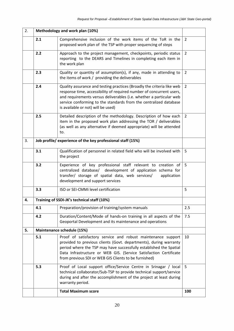
2. Methodology and work plan (10%)
2.1 Comprehensive inclusion of the work items of the ToR in the proposed work plan of the TSP with proper sequencing of steps
2
2.2 Approach to the project management, checkpoints, periodic status reporting to the DEARS and Timelines in completing each item in the work plan
2
2.3 Quality or quantity of assumption(s), if any, made in attending to the items of work / providing the deliverables
2
2.4 Quality assurance and testing practices (Broadly the criteria like web response time, accessibility of required number of concurrent users, and requirements versus deliverables (i.e. whether a particular web service conforming to the standards from the centralized database is available or not) will be used)
2
2.5 Detailed description of the methodology. Description of how each item in the proposed work plan addressing the TOR / deliverables (as well as any alternative if deemed appropriate) will be attended to.
2
3. Job profile/ experience of the key professional staff (15%)
3.1 Qualification of personnel in related field who will be involved with the project
5
3.2 Experience of key professional staff relevant to creation of centralized database/ development of application schema for transfer/ storage of spatial data, web services/ application development and support services
5
3.3 ISO or SEI-CMMi level certification 5
4. Training of SSDI-JK’s technical staff (10%)
4.1 Preparation/provision of training/system manuals 2.5
4.2 Duration/Content/Mode of hands-on training in all aspects of the Geoportal Development and its maintenance and operations
7.5
5. Maintenance schedule (15%)
5.1 Proof of satisfactory service and robust maintenance support provided to previous clients (Govt. departments), during warranty period where the TSP may have successfully established the Spatial Data Infrastructure or WEB GIS. (Service Satisfaction Certificate from previous SDI or WEB GIS Clients to be furnished)
10
5.3 Proof of Local support office/Service Centre in Srinagar / local technical collaborator/Sub-TSP to provide technical support/service during and after the accomplishment of the project at least during warranty period.
5
Total Maximum score 100

Request for Proposal –Establishment of State Spatial Data Infrastructure (J&K State Geo-portal)
21
15.8 Public Opening and Evaluation of Financial proposals: After the technical evaluation is completed, the DEARS shall inform the technically short listed TSP(s) who have submitted proposals, the technical scores obtained by their technical proposals, and shall notify those TSP(s) whose proposals did not meet the minimum qualifying mark or were considered non-responsive to the RFP and ToR, and their financial proposals will be returned unopened after completing the selection process. The DEARS shall simultaneously notify in writing to the TSP(s) who have secured the minimum qualifying mark for participating in the meeting, if they wish so, for opening of the financial proposals. The opening date should allow TSP(s) sufficient time to make arrangements for attending the opening. TSP(s)’ attendance at the opening of financial proposals is optional. Financial proposals of only those firms who are technically qualified shall be opened publicly on the date and time specified the data sheet (Section 2 Para 24) in the presence of the TSP/or their representatives who choose to attend. The financial proposal of the TSP(s) who met the minimum qualifying mark will then be inspected to consider that they have remained sealed and unopened. These financial proposals shall be then opened, and the total prices read aloud and recorded. The DEARS shall prepare a record of the public opening of financial proposals. TSPs should ensure that there are no arithmetic errors or over-writings in the financial proposals as otherwise the proposal shall be liable for rejection. 15.9 Short listing TSPs: The bidder who obtains 75% marks and above are to be treated as qualified for Financial Bid. Financial bids of only such qualified TSP(s) will be opened. After opening the financial proposals of technically qualified bidders (those who have obtained a minimum technical score= 75), the bidder who has quoted the lowest price for the assignment will be declared as the winner and be eligible for award of the contract. Financial bids of more than 25% over and above the estimated cost of the project of approximately Rs 200.00 lacs, shall be considered as unreasonable and therefore, liable to be rejected forthwith. Provided further, in case the financial bid quoted by two or more companies are equal/same, then the company which has secured the highest technical score in the technical bid out of the competing companies with equal/identical/same aggregate financial bid, shall be declared as winner for award of the contract. 15.10 Negotiations The TSP who is recommended for award of the contract will be called for both technical and
financial negotiations, the details of which are outlined below:
Negotiations will be held at the date and address indicated in the data sheet (Section 2 Para
24). Representatives conducting negotiations on behalf of the TSP must have written
authority to negotiate and conclude a contract.
15.10.1 Technical negotiations: Negotiations will include a discussion of the technical
proposal, the proposed technical approach and methodology, work plan, and organization
and staffing, and any suggestions made by the TSP to improve the terms of reference. The
DEARS and the TSP(s) will finalize the ToR, staffing schedule, work schedule, logistics, and

Request for Proposal –Establishment of State Spatial Data Infrastructure (J&K State Geo-portal)
22
reporting. These documents will then be incorporated in the Contract as description of
services. Special attention will be paid to clearly defining the inputs and facilities required
from the DEARS to ensure satisfactory implementation of the assignment. The DEARS shall
prepare minutes of negotiations which will be signed by the representatives of both DEARS
and TSP.
15.10.2 Financial negotiations: After the technical negotiations are over, financial
negotiations should be carried out in order to reflect any change in financials due to change
in scope of work or due to clarification on any aspect of the technical proposal during the
technical negotiations. Under no circumstance, the financial negotiation shall result in to
increase in the price originally quoted by the TSP.
If applicable, it is the responsibility of the TSP, before starting financial negotiations, to
contact the local tax authorities to determine the local tax amount to be paid by the TSP
under the contract. The financial negotiations will include a clarification (if any) of the TSP’s
tax liability, and the manner in which it will be reflected in the contract; and will reflect the
agreed technical modifications in the cost of the services.
15.11. Availability of professional staff/experts: Having selected the TSP on the basis of,
among other things, an evaluation of proposed professional staff, the DEARS expects to
negotiate a contract on the basis of the professional staff named in the proposal. Before
Contract negotiations, the DEARS will require assurances that the professional staff will be
actually available. The DEARS will not consider substitutions during contract negotiations
unless both parties agree that undue delay in the selection process makes such substitution
unavoidable or for reasons such as death or medical incapacity. If this is not the case and if
it is established that professional staff were offered in the proposal without considering
their availability, the TSP may be disqualified. Any proposed substitute shall have equivalent
or better qualifications and experience than the original candidate and be submitted by the
TSP within the period of time specified in the letter of invitation to negotiate.
15.12. Award of contract and commencement of work
After completing the negotiation, the DEARS shall issue a Letter of Acceptance, notifying
the award of contract to the selected TSP, who is L1, and promptly notify all other TSP(s)
who have submitted proposals about the final decision. After the Contract signature, the
DEARS shall return the unopened financial proposals to the unsuccessful TSP(s).
After fulfilling all the formalities/ preconditions mentioned in the standard form of contract
in Section-7, the TSP will sign a contract on a stamp paper worth 100/- within 15 days of
issuance of the letter of acceptance. The project completion period is with respect to the
date of signing of the contract.
15.8 Security Deposit: Within 15 days after receipt of the Letter of Acceptance, the
successful TSP will have to furnish along with the agreement a security deposit @ 2 % of the
value of the Contract or Rs. 10,00,000/- (Ten lakhs only) whichever is higher, in the form of a
Bank Guarantee on any Nationalized Bank (drawn in favour of Director, Ecology,
Environment & Remote Sensing, J&K Govt) valid for 24 months from the date of letter of

Request for Proposal –Establishment of State Spatial Data Infrastructure (J&K State Geo-portal)
23
intent with a provision of its further extension/ revalidation up to the period of warranty of
the total solution whichever is later. The requisite Performa for the Bank Guarantee is given
in Appendix-F.
The TSP is expected to commence and complete the assignment/job at the location
specified in the data sheet (Section 2 Para 24) within 24 weeks after signing the contract.
16. PAYMENTS FOR THE SERVICES
a. The total payment due to the Bidder shall not exceed the Contract Price which is an all-
inclusive fixed lump-sum covering all costs required to carry out the services as outlined in
section 3.
b. The security deposit will be released after the final deployment and successful tests.
c. Payment term will follow the following schedule:
i. 60% on supply and installation of required hardware and software
ii. 35% on Migrating GIS Data into RDBMS and Creation of centralized database, publishing
metadata in the Geo-portal, total system integration, final deployment and
operationalization of the entire system, development of applications/customization
and training of JK SSDI project staff.
iv. 05% on successful reinstallation of the Hardware, Software, networking and re-
operationalization of Geoportal in the new building complex to be constructed for of
SSDI-JK in the existing office campus or after 2 years of successful installation whichever
is later.
17. SUB-CONTRACTING OF THE PROJECT & CHANGE IN COMPANY STRUCTURE
Sub-contracting of the project shall not be allowed. Further, the TSP will be solely
responsible for the whole project and all of the conditions as laid under this RFP.
The Membership/Board structure of the TSP, if changed after the TSP is selected. The TSP
shall accordingly inform the DEARS of such changes and amend the contract wherever
applicable or deemed fit.
18. CONFIDENTIALITY
Information relating to evaluation of proposals and recommendations concerning award
shall not be disclosed to the TSP who submitted the proposals or to other persons not
officially concerned with the process, until the publication of the award of contract. The
undue use by any TSP of confidential information related to the process may result in the
rejection of its proposal and may be subject to the provisions of the Employer’s antifraud
and corruption policy.
19. COMMUNICATION

Request for Proposal –Establishment of State Spatial Data Infrastructure (J&K State Geo-portal)
24
The TSP should make sure that the solution proposed and the software applications
developed as part of this proposal will interact seamlessly with the communication facilities
already being set up or planned to be set up. Dedicated Broadband Internet Facility is
required at the location.
20. TRANSFER OF EQUIPMENT AND REINSTALLATION OF SAME IN NEW SSDI-JK BUILDING
TO BE CONSTRUCTED IN THE CAMPUS
The TSP shall visit the site before participating in the bid as the Geoportal shall have to be
developed and operationalized in the space provided in the existing building of the DEARS
and it shall have to be transferred and reinstalled in the new building to be constructed in
the same campus within the next two years. For this no extra charges shall have to be
claimed and it shall be deemed to be integrated in the lump sum bid offered by the TSP. In
case, the Department fails to construct the new building within 2 years from the date of
commencement of the operationalization of the geoportal, the Department is liable to
release the last installment of 05% to the company at the end of two years from the date of
operationalization of the geoportal.
21. WARRANTY AND MAINTENANCE
The TSP should provide warranty for the entire system, after the system is commissioned
and declared operational. The TSP is required to provide direct warranty for the
Hardware/application software developed as part of this project and Performance Warranty
of 3 years for the entire system.
22. CLARIFICATIONS
All information pertaining to the TSP’s technical approach to completing this project, as well
as the proposed price, time schedule and deliverables shall be included in the proposal. The
Director, DEARS reserves the right to amend this request for proposal at any time prior to
the deadline for submission of proposals and to reject any proposal received if he finds it to
be in the best interest of the DEARS.
23. FEE & TIME SCHEDULE
S. No. Event Deadline
1 Nonrefundable tender fee INR 5000 To be submitted in a
sealed envelope with
the bid document
subscribed as ‘RFP
document fee’.
2 Earnest Money Deposit (EMD)
INR 5 lakhs Along with bid
document in a sealed
envelope subscribed
as ‘EMD’.

Request for Proposal –Establishment of State Spatial Data Infrastructure (J&K State Geo-portal)
25
3 Publishing tender on website
4 Last date to receive requests for clarification of
tender(The TSP may email such requests at mail id:
5 Last date for submission of RFP document fee, EMD,
technical & financial tenders in separate sealed
covers within a single sealed cover duly marked.
22/07/2015
6 Evaluation of technical proposal and short listing TSPs To be notified
7 Opening of financial offers of technically qualified
TSP(s)
To be notified
8 Final selection of TSP
To be notified
9 Signing of agreement
To be notified
10 The work expected to be initiated To be notified
11 Expected date of completion of work 8 months after
signing the
agreement
Note: The dates furnished above are subject to revision.
24. DATA SHEET
Clause
1.0 General
1.1 Name of the Employer Department of Ecology, Environment & Remote
Sensing, Government of Jammu & Kashmir, SDA
Colony, Bemina, Srinagar, 190018 Kashmir/
Gladeni, Jammu Tawi
1.2 Method of selection Quality and Least Cost Based selection(QLCBS)
1.3 Nature of the proposals requested Technical and Financial proposals in separate
sealed covers
1.4 Name, objectives, and description of
assignment
a)Setting up of Geoportal (Real world Object
catalogue, Conceptual data model, creation of
centralized database as per NSDI standards,
metadata, its publishing and development of
cataloguing services) in existing building of

Request for Proposal –Establishment of State Spatial Data Infrastructure (J&K State Geo-portal)
26
DEARS temporarily.
b)Customization of data/software and
development of applications for users as per
Terms of reference(ToR)
c) Transfer and reinstallation of equipment and
operationalization of Geoportal, in the new
building to be constructed in the campus of
DEARS in next two years.
1.5 Reference Letter of Invitation for details
1.6 Publishing of tender Document
1.7 Proposal submission address Department of Ecology, Environment & Remote
Sensing(DEARS), SDA Housing Colony, Bemina,
Srinagar, Kashmir, J&K State, India-190018
1.8 Estimated number of calendar months
required for the assignment
Assignment (a) and (b) should be completed
within 8 calendar Months
Assignment (c) should be completed within two
months from the date of intimation of readiness of
the newly constructed building.
1.9 Validity of proposal 90 days after the bid submission date
1.10 The DEARS’s representative is Addl. PCCF/Director, Department of Ecology, Environment & Remote Sensing(DEARS), Govt. of J&K State, SDA Housing Colony, Bemina, Srinagar, Kashmir, J&K-190018
ParyavaranBhavan, Jammu Tawi-180010
Phone/Fax: 0194-2490823,
Mobile: 09419195708
Email: [email protected]
1.13 Last date of submission of proposal
(both technical and financial)
22-07-2015 till 16:00 hrs
1.14 The formats of the technical proposal
to be submitted are
As per the respective Sections
1.15 The assignment is expected to commence by ending August,2015
2.0 Clarifications
2.1 Clarifications requisition by email
2.2 Address for clarification requisition As per section 1.12 of Data Sheet
3.0 Submission of proposal

Request for Proposal –Establishment of State Spatial Data Infrastructure (J&K State Geo-portal)
27
3.1 Language of proposal submission English
3.2 Information on the outer envelope Setting up of SSDI-JK Geoportal, to be opened in
the presence of Evaluation Committee.
3.3 No. of copies of proposal to be
submitted
An original duly signed and one additional copy of
each technical and financial proposal
3.4 Additional information in technical
proposal includes
Past experience in executing similar assignments
like development of geo portal, certification of
recognition issued by competent authorities, etc.,
be attached with bid technical document.
3.5 Proposal accepted after due date and
time
No
3.6 Whether any short listed TSP can
associate with other short listed TSP(s)
No
3.7 Whether the work can be sub-
contracted
No
4.0 Training Activities
4.1 Training Training is a specific component of this
assignment. The SSDI-JK staff needs to be trained
in handling and maintenance of the Geoportal and
the SSDI-JK datasets.
5.0 Cost of Services
5.1 Cost of executing the project Split up of cost of services to be quoted as per the
format in Section 3. including lump sum
5.2 Taxes The TSP(s) should include statutory taxes such as
income tax, VAT and other indirect taxes in the
price proposal. The proposal shall be all inclusive
5.3 Currency referred to in the bid Indian Rupees
25. BID REJECTION CRITERIA
Besides other terms and conditions highlighted in the tender document, bids may be
rejected under the following circumstances:
25.1 General Rejection Criteria
Request for Proposal –Establishment of State Spatial Data Infrastructure (J&K State Geo-portal)
28
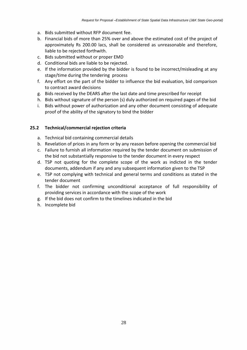
a. Bids submitted without RFP document fee. b. Financial bids of more than 25% over and above the estimated cost of the project of
approximately Rs 200.00 lacs, shall be considered as unreasonable and therefore, liable to be rejected forthwith.
c. Bids submitted without or proper EMD d. Conditional bids are liable to be rejected. e. If the information provided by the bidder is found to be incorrect/misleading at any
stage/time during the tendering process f. Any effort on the part of the bidder to influence the bid evaluation, bid comparison
to contract award decisions g. Bids received by the DEARS after the last date and time prescribed for receipt h. Bids without signature of the person (s) duly authorized on required pages of the bid i. Bids without power of authorization and any other document consisting of adequate
proof of the ability of the signatory to bind the bidder
25.2 Technical/commercial rejection criteria
a. Technical bid containing commercial details b. Revelation of prices in any form or by any reason before opening the commercial bid c. Failure to furnish all information required by the tender document on submission of
the bid not substantially responsive to the tender document in every respect d. TSP not quoting for the complete scope of the work as indicted in the tender
documents, addendum if any and any subsequent information given to the TSP e. TSP not complying with technical and general terms and conditions as stated in the
tender document f. The bidder not confirming unconditional acceptance of full responsibility of
providing services in accordance with the scope of the work g. If the bid does not confirm to the timelines indicated in the bid h. Incomplete bid
Request for Proposal –Establishment of State Spatial Data Infrastructure (J&K State Geo-portal)
29
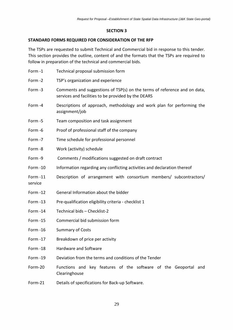
SECTION 3
STANDARD FORMS REQUIRED FOR CONSIDERATION OF THE RFP
The TSPs are requested to submit Technical and Commercial bid in response to this tender.
This section provides the outline, content of and the formats that the TSPs are required to
follow in preparation of the technical and commercial bids.
Form -1 Technical proposal submission form
Form -2 TSP’s organization and experience
Form -3 Comments and suggestions of TSP(s) on the terms of reference and on data,
services and facilities to be provided by the DEARS
Form -4 Descriptions of approach, methodology and work plan for performing the
assignment/job
Form -5 Team composition and task assignment
Form -6 Proof of professional staff of the company
Form -7 Time schedule for professional personnel
Form -8 Work (activity) schedule
Form -9 Comments / modifications suggested on draft contract
Form -10 Information regarding any conflicting activities and declaration thereof
Form -11 Description of arrangement with consortium members/ subcontractors/
service
Form -12 General Information about the bidder
Form -13 Pre-qualification eligibility criteria - checklist 1
Form -14 Technical bids – Checklist-2
Form -15 Commercial bid submission form
Form -16 Summary of Costs
Form -17 Breakdown of price per activity
Form -18 Hardware and Software
Form -19 Deviation from the terms and conditions of the Tender
Form-20 Functions and key features of the software of the Geoportal and
Clearinghouse
Form-21 Details of specifications for Back-up Software.

Request for Proposal –Establishment of State Spatial Data Infrastructure (J&K State Geo-portal)
30
FORM 1
Technical Proposal Submission Form
To
The Director
Department of Ecology, Environment & Remote Sensing
SDA Housing Colony, Bemina, 190018, Srinagar, J&K State
Sub: Setting up of State Spatial Data Infrastructure (J&K State Geo-portal) and
development of applications for users:
Tender No. …………………
Sir,
We the undersigned TSP, having read and examined in detail all the tender Documents in
respect of appointment of Total Solution Provider for providing the infrastructure for setting
up of State Spatial Data Infrastructure (J&K State Geo-portal), and development of
applications for users at Bemina, Srinagar, do hereby propose to provide the services as
specified in the tender Document No. ………. and submit our proposal, which includes this
technical proposal, and a financial proposal sealed under separate envelopes enclosed
within a single envelope duly marked as indicated in the RFP.
We have enclosed EMD in the form of a demand Draft for a sum of …………. (Rupees
…………….). The EMD is liable to be forfeited in accordance with the provision of the tender
document. We declare that all services will be performed in accordance with the tender
document except for the variations, assumption and deviations all of which have been
detailed out exhaustively in the following document, irrespective of whatever has been
stated to the contrary anywhere else in our bid.
We are submitting our proposal in association with: [Insert a list with full name and address
of each associated TSP, if applicable]. In case we fail to execute the agreement as aforesaid
incorporating the terms and conditions governing the contract, DEARS shall have power and
authority to recover from us any loss or damages caused to DEARS by such breach as may
be determined by DEARS, appropriating the EMD deposited by us and if the EMD is found to
be inadequate, the deficit amount may be recovered from us and our properties movable
and immovable.

Request for Proposal –Establishment of State Spatial Data Infrastructure (J&K State Geo-portal)
31
We hereby declare that our tender is made in good faith, without collusion or fraud and the
information contained in the tender is true to the best of our knowledge and belief and any
misinterpretation contained in it may lead to our disqualification. If negotiations are held
during the period of validity of the proposal, i.e., before the date indicated in Paragraph
Reference we undertake to negotiate on the basis of the proposed staff.
Our proposal is binding upon us and subject to the modifications resulting from Contract
negotiations. We undertake, if our proposal is accepted, we would initiate the consulting
services related to the assignment not later than the date indicated in of the data sheet
(Section 2, para 24.). We understand that you are not bound to accept any proposal that
you receive.
Thanking You,
Location: Date :
Yours sincerely,
Authorized Signature:
Name and Title of Signatory:
Name of TSP & Address:

Request for Proposal –Establishment of State Spatial Data Infrastructure (J&K State Geo-portal)
32
Form 2
TSP’S Organization and Experience
A - TSP’s Organization
[Provide here a brief description of the background and organization of your firm/entity and each
associate for this assignment/job. The brief description should include ownership details, date and
place of incorporation of the firm, objectives of the firm etc. Also if the TSP has formed a
consortium, details of each of the member of the consortium, name of lead members etc shall be
provided]
B - TSP’s Experience
[Using the format below, provide information on each Assignment/job for which your firm, and each
partner in the case of consortium or joint venture, was legally contracted either individually as a
corporate entity or as one of the major partners within an association, for carrying out consulting
Assignment/job similar to the ones requested under this Assignment/job (If possible, the DEARS shall
specify exact assignment / job for which experience details may be submitted). In case of
consortium, the TSP must furnish the following information for each of the consortium member
separately]
1. Firms Name: 2. Assignment/job Name: 2.1 Description of Project 2.2 Approximate value of the contract (in Rupees)

Request for Proposal –Establishment of State Spatial Data Infrastructure (J&K State Geo-portal)
33
2.3 Country 2.4 Location within Country: 2.5 Duration of the Assignment/job (months) 2.6 Name of the employee: 2.7 Address: 2.8 Total No of staff-months of the Assignment/job: 2.9 Approx. value of the Assignment/job provided by your firm under the contract (in Rupees): 2.10 Start date (month/year): 2.11 Completion date (month/year): 2.12 Name of associated TSP, if any: 2.13 No of professional staff-months provided by associated TSP: 2.14 Name of senior professional staff of your firm involved and functions performed. 2.15 Description of actual assignment/job provided by your staff within the assignment/job:
Note: Please provide documentary evidence form the employers i.e. copy of work order, contract for
each of above mentioned assignment. The experience shall not be considered for evaluation if such
requisite supporting documents are not provided with the proposal.
(Signature of the TSP)
Address:

Request for Proposal –Establishment of State Spatial Data Infrastructure (J&K State Geo-portal)
34
Form 3
Comments and Suggestions (if any) of TSPs on the Terms of Reference and on
Data, Services and Facilities
A. On the Terms of Reference:
1.
2.
3.
4.
5.
[Suggest and justify here any modifications or improvement to the ToR you are proposing to
improve performance in carrying out the assignment/job (such as deleting some activity you
consider unnecessary, or adding another, or proposing a different phasing of the activities). Such
suggestions should be concise and to the point, and incorporated in your proposal.]
B - On inputs and facilities to be provided by the DEARS
[Comment here on inputs and facilities to be provided by the DEARS according to paragraph 6 of the
special information to TSP including: administrative support, office space, data, etc.]
1.
2.
3.
(Signature of the TSP)
Address:
(The DEARS is not bound to accept the comments and suggestions (if any) of TSPs on the terms of
reference and on data, services and facilities)
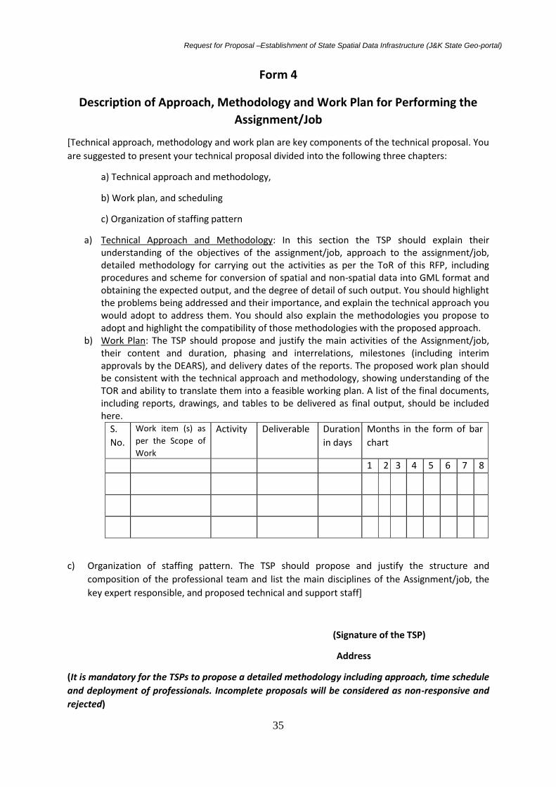
Request for Proposal –Establishment of State Spatial Data Infrastructure (J&K State Geo-portal)
35
Form 4
Description of Approach, Methodology and Work Plan for Performing the
Assignment/Job
[Technical approach, methodology and work plan are key components of the technical proposal. You
are suggested to present your technical proposal divided into the following three chapters:
a) Technical approach and methodology,
b) Work plan, and scheduling
c) Organization of staffing pattern
a) Technical Approach and Methodology: In this section the TSP should explain their understanding of the objectives of the assignment/job, approach to the assignment/job, detailed methodology for carrying out the activities as per the ToR of this RFP, including procedures and scheme for conversion of spatial and non-spatial data into GML format and obtaining the expected output, and the degree of detail of such output. You should highlight the problems being addressed and their importance, and explain the technical approach you would adopt to address them. You should also explain the methodologies you propose to adopt and highlight the compatibility of those methodologies with the proposed approach.
b) Work Plan: The TSP should propose and justify the main activities of the Assignment/job, their content and duration, phasing and interrelations, milestones (including interim approvals by the DEARS), and delivery dates of the reports. The proposed work plan should be consistent with the technical approach and methodology, showing understanding of the TOR and ability to translate them into a feasible working plan. A list of the final documents, including reports, drawings, and tables to be delivered as final output, should be included here.
S.
No.
Work item (s) as
per the Scope of
Work
Activity Deliverable Duration
in days
Months in the form of bar
chart
1 2 3 4 5 6 7 8
c) Organization of staffing pattern. The TSP should propose and justify the structure and
composition of the professional team and list the main disciplines of the Assignment/job, the
key expert responsible, and proposed technical and support staff]
(Signature of the TSP)
Address
(It is mandatory for the TSPs to propose a detailed methodology including approach, time schedule
and deployment of professionals. Incomplete proposals will be considered as non-responsive and
rejected)

Request for Proposal –Establishment of State Spatial Data Infrastructure (J&K State Geo-portal)
36
FORM 5
Team composition and task assignments/jobs
1. Professional/ Managerial Staff
Name of staff Area of expertise Position Task assigned
2. Support staff
Name of staff Area of expertise Position Task assigned
(Signature of the TSP)
Address

Request for Proposal –Establishment of State Spatial Data Infrastructure (J&K State Geo-portal)
37
FORM 6
Professional Staff available with the company
S. No.
Position Name of staff member Qualification, Experience and Expertise
1
2
3
4
5
6
7
8
9
10

Request for Proposal –Establishment of State Spatial Data Infrastructure (J&K State Geo-portal)
38
Certification: I, the undersigned, certify that to the best of my knowledge and belief, the above details are correctly described. I understand that any willful misstatement described herein may lead to my disqualification or dismissal, if engaged. Date: [Signature of authorized representative of the TSP] Day/Month/Year Full name of Staff Member : Full name of authorized representative & Sign:
(Signature of the TSP)
Address

Request for Proposal –Establishment of State Spatial Data Infrastructure (J&K State Geo-portal)
39
FORM 7
TIME SCHEDULE FOR PROFESSIONAL PERSONNEL
Full-time: Part-time:
Deliverable/ Reports Due:
Activities Duration:
S.No Name of staff Position Deliverables/report
due /activities
Months (staff input in the form of bar
chart)
1 2 3 4 5 6 7 8
Note:
a. For Professional Staff the input should be indicated individually; for Support Staff it should be indicated by category (e.g.: GIS expert, programmer, Tester, etc.).
b. Months are counted from the start of the Assignment/job. For each staff indicate separately staff input for home and field work.
Signature:
(Authorized representative)
Full Name:
Title:
Address:

Request for Proposal –Establishment of State Spatial Data Infrastructure (J&K State Geo-portal)
40
FORM 8
Work (activity) schedule
S. No. Activity (work) Months from the start of assignment
1 2 3 4 5 6 7 8
1 Indicate all main activities of the Assignment/job, including delivery of reports (e.g.: inception, interim, draft and final reports. For phased assignment/jobs indicate activities, delivery of reports, and benchmarks separately for each phase.
2 Duration of activities shall be indicated in the form of a bar chart. Completion and Submission of Deliverables/ Reports
Reports
S.No. Deliverables/ reports Date
1 Inception report
2 Interim Progress
(a) First Status Report
(b) Second Status Report
3 Draft Report version
4 Final Report version
Signature of TSP

Request for Proposal –Establishment of State Spatial Data Infrastructure (J&K State Geo-portal)
41
FORM 9
Comments / Modifications Suggested on Draft Contract
[Here the TSP shall mention any suggestion / views on the draft contract attached with the RFP
document. The TSP may also mention here any modifications sought by him in the provisions of the
draft contract. This information shall be used at the time of the negotiations. However, the DEARS is
not bound to accept any/all modifications sought and may reject any such request of modification.]
Signature of TSP

Request for Proposal –Establishment of State Spatial Data Infrastructure (J&K State Geo-portal)
42
FORM 10
Information Regarding Any Conflicting Activities and Declaration thereof
Are there any activities carried out by your firm or group company or any member of the consortium which are of conflicting nature as mentioned in para 5 of section 2. If yes, please furnish details of any such activities. If no, please certify, We hereby declare that our firm, our associate / group firm or any of the member of the consortium are not indulged in any such activities which can be termed as the conflicting activities under para 5 of the section 2. We also acknowledge that in case of misrepresentation of the information, our proposals / contract shall be rejected / terminated by the Employer which shall be binding on us.
Authorized Signature [In full and initials]:
Name and Title of Signatory:
Name of Firm:
Address:
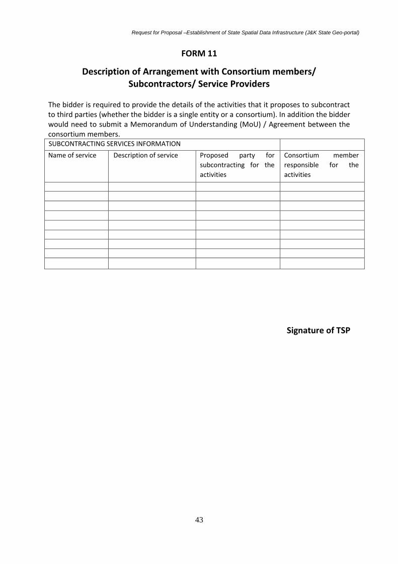
Request for Proposal –Establishment of State Spatial Data Infrastructure (J&K State Geo-portal)
43
FORM 11
Description of Arrangement with Consortium members/ Subcontractors/ Service Providers
The bidder is required to provide the details of the activities that it proposes to subcontract to third parties (whether the bidder is a single entity or a consortium). In addition the bidder would need to submit a Memorandum of Understanding (MoU) / Agreement between the consortium members. SUBCONTRACTING SERVICES INFORMATION
Name of service Description of service Proposed party for
subcontracting for the
activities
Consortium member
responsible for the
activities
Signature of TSP

Request for Proposal –Establishment of State Spatial Data Infrastructure (J&K State Geo-portal)
44
FORM 12
General Information about the bidder
S.No. Description
1 Name of the bidder
2 Address of the bidder
3 Name and designation of the contact person
to whom all references shall be made
regarding the tendering
4 Telephone No.(with STD code)
5 E-mail of the contact person
6 Fax No. of the contact person with STD code
7 Website
Signature of TSP

Request for Proposal –Establishment of State Spatial Data Infrastructure (J&K State Geo-portal)
45
FORM 13
Pre-qualification eligibility criteria and proof requirement
S.NO. Clause Documents required yes/no
1 The bid can be submitted by a
PSU/Company/Consortium
In case of consortium applicant, the
consortia will submit a valid
Memorandum of Understanding
(MOU)/Agreement
Consortium means more than one company
which joins with other companies of
complementing skills to undertake the scope
of work defined in the RFP
MOU/agreement signed by the authorized
signatories dated prior to submission of bid
2 The TSP (prime) should be a company
registered under the Indian Companies
Act 1956, or Companies under Indian
Partnership Act at least since last 3 years
Certificate of incorporation
3 The TSP should be an ISO or SEI CMMi
Certified Company
Valid copy of relevant & attested certificates
to be attached.
4 The TSP must be a reputed company
relating to Geospatial technologies with
experience in execution of projects in
Geospatial sector for the last three years
as on 01-01-2015.
Work orders confirming year and area of
activity. Memorandum and Articles of
Associations
5 Capable of providing turnkey solutions in
designing, developing and implementing
projects in the field of IT, establishment
of data centers, Remote Sensing, GIS,
development of Web GIS application,
portal development, involving supply of
GIS related hardware/software - its
installation, integration and
customization for at least three years in
India or overseas. The TSP should have
successfully accomplished at least one
such WebGIS or SDI related Project
worth equal to or more than 50.00 lakhs
project budget.
Copy of work orders confirming area of
activity and memorandum and articles of
associations.
6 The TSP (prime) must have on its roll
at least 10 permanent Technical Skilled
Persons working for GIS/remote sensing,
IT, activities out of which 03 staff should
be involved in the development of SDI or
Web GIS application activities. Necessary
Certificate from TSPs’ HR Department for
number of technically qualified professionals
employed by the company.

Request for Proposal –Establishment of State Spatial Data Infrastructure (J&K State Geo-portal)
46
proof should be attached. Proof of key
staff should be submitted.
7 The bidding TSP should have experience
of having completed at least three
projects involving major portal
development/GIS application
development/WebGIS. One such project
should be for any departments of Govt.
of India or any other State Govt.
department
Submit attested copies of work orders of
each such project from the client.
8 One of the SDI or WEB GIS projects
should have been completed using OGC
compliant technology
Necessary proof to be attached
9. The TSP should have registered corporate office or an authorized distributor office in India
Relevant Documents or Undertaking signed by the Authorized Signatory
10 The TSP’s having a local office /service center in Srinagar or a local collaborator for providing technical support during and after the execution of the work shall be preferred, though it is not mandatory.
Relevant Documents to be attached with undertaking signed by the Authorized Signatory
11 The bidding firm/company/concern
must have made profits as per the
balance sheets in the last three financial
years i.e.2012-2013 and 2013-2014 and
2014-2015 and should be in sound
financial position. A copy of last three
financial year’s relevant audited balance
sheets up to 31.3.2015 must be
submitted along with the bid.
Copy of the Balance Sheet, IT returns and
audited profit and loss account of the
company, attested by the Chartered
Accountant showing turnover of the
company for last three years.
The bidders should separately submit
account detail sheets for each of their
activities, i.e., services and product sales.
12 The TSP and all consortium partners
shall not be under a Declaration of
Ineligibility for corrupt or fraudulent
practices or blacklisted with any of the
Government agencies.
Declaration in this regard by the authorized
signatory of the (Prime) TSP
13 The TSP (prime) should submit valid
letter from OEM’s confirming the
following :
1. Authorization for TSP for supply of hardware/software
2. Confirm that the products quoted are not end of life
1. Letter of authorization of TSP (prime)
from OEM
2. Confirmation letter from the for items 1
& 2
Undertaking from OEMs should include:
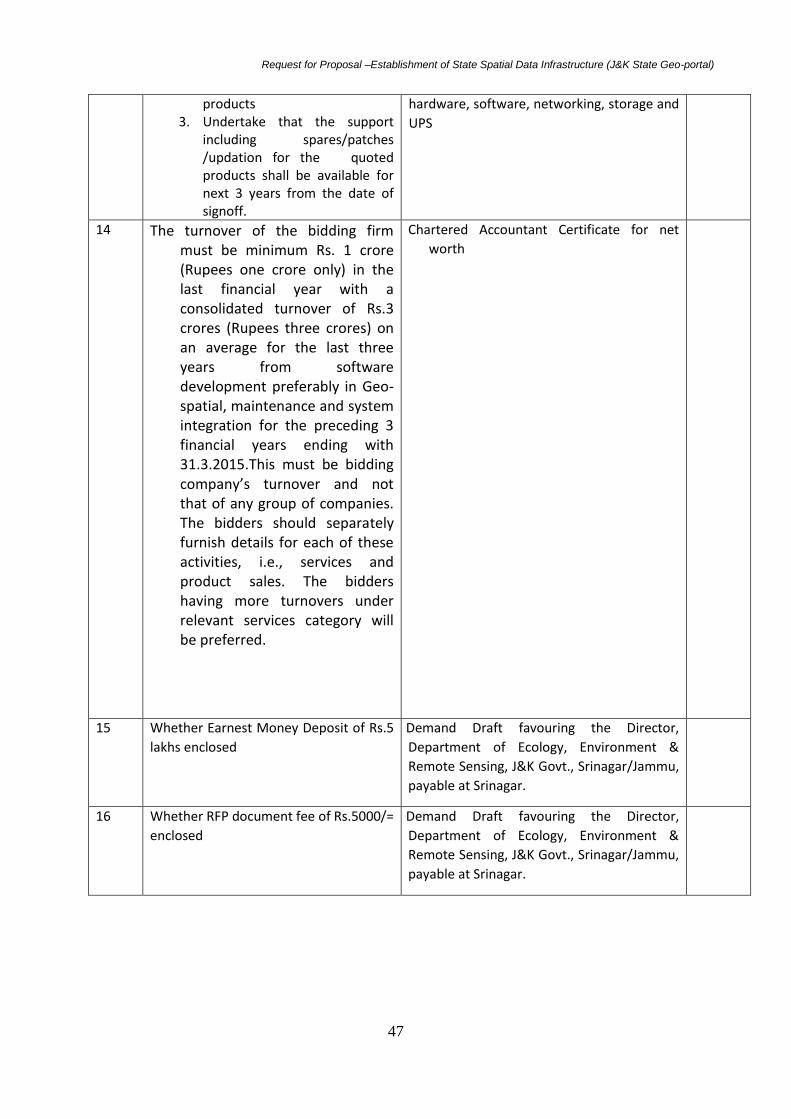
Request for Proposal –Establishment of State Spatial Data Infrastructure (J&K State Geo-portal)
47
products 3. Undertake that the support
including spares/patches /updation for the quoted products shall be available for next 3 years from the date of signoff.
hardware, software, networking, storage and
UPS
14 The turnover of the bidding firm must be minimum Rs. 1 crore (Rupees one crore only) in the last financial year with a consolidated turnover of Rs.3 crores (Rupees three crores) on an average for the last three years from software development preferably in Geo-spatial, maintenance and system integration for the preceding 3 financial years ending with 31.3.2015.This must be bidding company’s turnover and not that of any group of companies. The bidders should separately furnish details for each of these activities, i.e., services and product sales. The bidders having more turnovers under relevant services category will be preferred.
Chartered Accountant Certificate for net
worth
15 Whether Earnest Money Deposit of Rs.5
lakhs enclosed
Demand Draft favouring the Director,
Department of Ecology, Environment &
Remote Sensing, J&K Govt., Srinagar/Jammu,
payable at Srinagar.
16 Whether RFP document fee of Rs.5000/=
enclosed
Demand Draft favouring the Director,
Department of Ecology, Environment &
Remote Sensing, J&K Govt., Srinagar/Jammu,
payable at Srinagar.
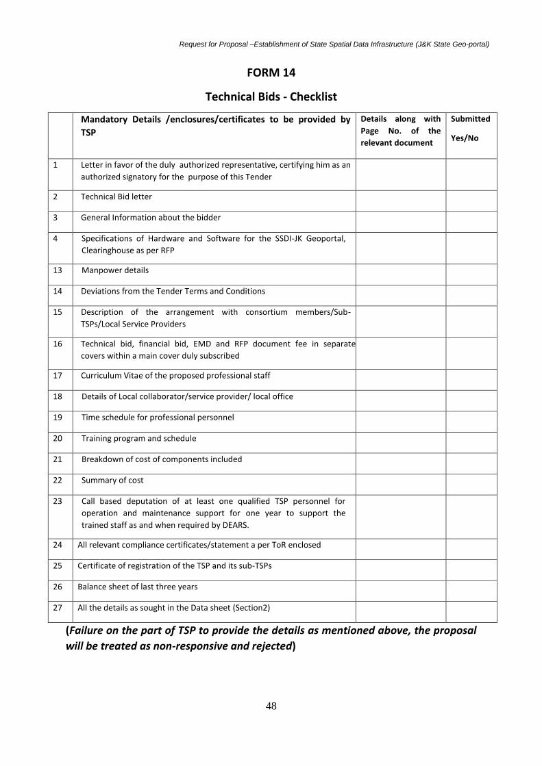
Request for Proposal –Establishment of State Spatial Data Infrastructure (J&K State Geo-portal)
48
FORM 14
Technical Bids - Checklist
Mandatory Details /enclosures/certificates to be provided by
TSP
Details along with
Page No. of the
relevant document
Submitted
Yes/No
1 Letter in favor of the duly authorized representative, certifying him as an
authorized signatory for the purpose of this Tender
2 Technical Bid letter
3 General Information about the bidder
4 Specifications of Hardware and Software for the SSDI-JK Geoportal,
Clearinghouse as per RFP
13 Manpower details
14 Deviations from the Tender Terms and Conditions
15 Description of the arrangement with consortium members/Sub-
TSPs/Local Service Providers
16 Technical bid, financial bid, EMD and RFP document fee in separate
covers within a main cover duly subscribed
17 Curriculum Vitae of the proposed professional staff
18 Details of Local collaborator/service provider/ local office
19 Time schedule for professional personnel
20 Training program and schedule
21 Breakdown of cost of components included
22 Summary of cost
23 Call based deputation of at least one qualified TSP personnel for
operation and maintenance support for one year to support the
trained staff as and when required by DEARS.
24 All relevant compliance certificates/statement a per ToR enclosed
25 Certificate of registration of the TSP and its sub-TSPs
26 Balance sheet of last three years
27 All the details as sought in the Data sheet (Section2)
(Failure on the part of TSP to provide the details as mentioned above, the proposal
will be treated as non-responsive and rejected)

Request for Proposal –Establishment of State Spatial Data Infrastructure (J&K State Geo-portal)
49
Form15
Commercial Bid Submission Form
[Location, Date]
To:
The Director
Department of Ecology, Environment & Remote Sensing
SDA Housing Colony, Bemina, Srinagar, 190018
Sir,
Sub: Setting up of State Spatial Data Infrastructure (J&K State Geo-portal), Clearinghouse
and development of applications for users.
Tender No. …………………
We the undersigned TSP, having read and examined in detail all the tender documents in respect of
appointment of Total Solution Provider for infrastructure by providing hardware and software for JK
SSDI , development of a Geo-portal and Clearinghouse, development of applications for users, at
Bemina, Srinagar, do hereby propose to provide the services as specified in the tender Document
No. …………
1. Price and validity
a. All the prices in our tender are in accordance with the terms and conditions as specified in the tender document. The prices and other terms and conditions are valid for a period of 90 calendar days from the date of opening the tender
b. We hereby confirm that our tender prices are all inclusive
2. Earnest money deposit
We have enclosed EMD in the form of a demand draft for a sum of RS 500000/- (Rupees Five
lakhs only) in favour of Director, Department of Ecology, Environment & Remote Sensing,
payable at Srinagar. The EMD is liable to be forfeited in accordance with the provision of the
contract.

Request for Proposal –Establishment of State Spatial Data Infrastructure (J&K State Geo-portal)
50
3. Deviations We declare that all services will be performed in accordance with the tender document except for
the variations and deviations all of which have been detailed out exhaustively in our bid document,
irrespective of whatever has been stated to the contrary anywhere else in our bid.
4. Tender pricing We further conform that the prices stated in our bid are in accordance with your instruction to TSPs
included in the tender document
5. Qualifying data We confirm that having submitted the information required by you in your information to TSPs, In
case the DEARS require any further information/clarification/ documentary proof in this regard
before evaluation of our tender, we agree to furnish the same to your satisfaction.
6. Bid price We declare that our bid price is __________________( in words)______________________for the
entire scope of the work as specified in the tender document.
7. Contract performance guarantee bond We hereby declare that in case the contract is awarded to us, we shall submit the contract
performance guarantee bond
In case we fail to execute the agreement as aforesaid incorporating the terms and conditions
governing the contract, DEARS shall have power and authority to recover from us any loss or
damages caused to DEARS by such breach as may be determined by DEARS, appropriating the EMD
deposited by us and if the EMD is found to be inadequate, the deficit amount may be recovered
from us and our properties movable and immovable.
We hereby declare that our tender is made in good faith, without collusion or fraud and the
information contained in the tender is true to the best of our knowledge and belief.
We understand you are not bound to accept any proposal you receive.
Thanking You,
Yours faithfully,
Authorized Signature: Name and Title of Signatory: Name of Firm: Address:

Request for Proposal –Establishment of State Spatial Data Infrastructure (J&K State Geo-portal)
51
FORM 16
Summary of Costs:
S. No Particulars Amount in Rs. Amount in words
1 Total cost of Hardware component(Supply and
installation)
2 Total cost of Software component(Supply and
installation)
3 Geoportal Development and maintenance costs
(Requirement Analysis, Site preparation, Creation
of Metadata, Real world Object catalogue,
Conceptual/physical data model, Customization of
Geoportal Interface, Operationalization of SSDI-JK
Geo-portal)
4 Transfer and reinstallation of the equipment and
Geoportal and its operationalization in the new
building to be constructed in the DEARS campus in
the next two years.
5 Local Taxes: such as VAT, Service Tax etc. (if any)
6 Consolidated cost in Rupees
(The TSP can include additional items if required)
Authorized Signature :
Name :
Designation:
Name of TSP with seal firm :
Date:
NOTE:-
1 No cost will be borne by the DEARS in case a job is repeated or rejected. If a job is repeated, it will be done at the own cost of the TSP(s).
2 The above cost figure will not be subject to any escalation and the price shall remain valid till completion of the project.
3 Financial bids are to be given in separate sealed cover.
(Signature of the TSP)

Request for Proposal –Establishment of State Spatial Data Infrastructure (J&K State Geo-portal)
52
Form 17: Breakdown of Price per Activity
Please use the tables below for providing the detailed breakdown of costs. Table format may be
suitably modified by addition of rows if necessary.
SSDI-JK Geo-portal/ clearinghouse development
(Signature of the TSP)
S.No. Description Total (Rs)
1 Requirement analysis and Need Assessment report
2 Site preparation
3 Development of Real World Object catalogue
4 Development of Conceptual/ physical data model
5 Hardware procurement & installation
6 Software procurement & installation
7 Compilation and publishing of data and metadata
8 Creation of centralized data base as per OGC standards
9 Customization of the Geoportal as per requirement
10 Testing of Geoportal in the existing building of DEARS
11 Transfer and reinstallation of the equipment and Geoportal and its
operationalization in the new building to be constructed in the DEARS
campus in the next two years.
12 Training to SSDI-JK Staff in the operations and maintenance of the
Geoportal
13 Warranty on hardware for 3 years and maintenance support for one
year from the date of commissioning of the Geoportal
14 Total Local Taxes: such as VAT, Service Tax etc.
15 Consolidated cost in Rupees

Request for Proposal –Establishment of State Spatial Data Infrastructure (J&K State Geo-portal)
53
Form 18:
Hardware and Software costs (Without Local Taxes: such as VAT, Service Tax etc.)
1. Hardware
S. No. Description Specifications Units Unit cost Total cost in Rs
A Hardware
1
2
3
B Software
1
2
3
Total amount
(Signature of the TSP)

Request for Proposal –Establishment of State Spatial Data Infrastructure (J&K State Geo-portal)
54
FORM 19
Deviation from the Terms and Conditions of Tender (if any)
S.No Section No. Clause No. Page No. Statement of deviation/variation Remarks
(Signature of the TSP)

Request for Proposal –Establishment of State Spatial Data Infrastructure (J&K State Geo-portal)
55
FORM20
Key features of the software of the Geoportal and Clearinghouse
The Web server will host the portal application. User will connect to this application over the Internet. This application runs on the Web server and will interact with Database server. Only authorized users will have access to the specific portal services. It is expected that initially the portal might attract 200 concurrent users and once the portal stabilizes the number concurrent users may go up to 1000.
S.no Description Yes/No
1 The SSDI JK Geoportal should be available in both web based and smart
phone android app. Besides, the website / Mobile application user
interface should be available in English. V
2 The website will have a combination of both static and dynamic pages. By
dynamic pages, it is meant, User Response Driven pages, pages which needs
user inputs for querying maps, making inputs to the database, feedbacks,
etc.
3 The geoportal should be cross browser compatible and should auto fit to
any screen resolution (should have tab and mobile versions). The Geo Portal
should be responsive to different devices, i.e., to be able to fit and work
properly on desktop and hand held devices, e.g, Tablets, smart phones.
4 The vendor should provide APIs for further application development and
improvement.
5 The Geoportal should provide reports along with maps, user should be able
to generate graphs, etc while exporting the maps.
6 Provision should be made to allow the admin to modify and customize user
interface at any time. Accessible for customization through industry
standard programming languages such as JAVA,C#, NET, Silverlight, Flex,
etc.
7 Users must be able to import information from major geoportals like
Google Earth, bing, Bhuvan, etc.
8 Provision to view versioned raster data as time series.
9 Geoportal should have a forum for the discussion and interaction between
users of geoportal from different line departments or general registered
users. Also Allows interactive communication and collaboration within a
network of users and communities. This could be made available through
blogs.
10 Support for multispatial multi attribute queries on existing data.
11 Geoportal should support graphical queries.
12 Provision should be there to alert or convey the Administrator immediately

Request for Proposal –Establishment of State Spatial Data Infrastructure (J&K State Geo-portal)
56
if any of the server components (Hardware and Software) functions down.
13 Geoportal should have a separate user-interactive help module like Live
Chat, and should be incorporated in the Geo Portal for interactive help.
14 Crowd sourcing of data through various GPS enabled devices with online
connectivity such as smart phones, tabs, etc. By crowd sourcing, we mean
the end user can voluntarily update the data (e.g., a local user who finds the
wrongly placed or named point, can initiate the update request, and the
updation will be reflected on the Geo portal after the verification or
authentication by the data manager). Similarly, a department can initiate
update request of their newly updated data on our database. The server
should have versioning facility to view multiple versions.
15 Geoportal should provide print facility ranging from A0-A4 or custom size
16 Separate URL should be provided to the admin where the admin can make
changes to geoportal through a GUI, e.g migration of data, publishing of
data, approving of data updated by the data providers
17 An embed link or URL should be there on the geoportal (like we have on
Google maps) so that the users can embed or use our map in their own
websites or portals.
18 Data should be downloadable by only users authenticated by the admin.
Admin should be able to give roles to the different users on geoportal i.e.,
Access/process/download/modify geo-spatial data.
19 Social share plugins should be there, like, FB, twitter, linked in etc, so that
users are able to post the links on social networking sites. Geoportal should
allow the registered users, the option of adding a place or location to
favorites i.e place marking and tagging for the registered users.
20 The geoportal should support information in the form of Text, Maps,
satellite images and Multi-media.
21 The geoportal should be developed using contemporary technologies
keeping in view that the user community uses a wide variety of operating
systems, computer configurations, browsers and band width.
22 Separate domain registration will be made for this geoportal and will be the
responsibility of the Department.
23 Provision is to be made for receiving public inputs from registered users
through dedicated email and also through query form inbuilt in the website.
24 The interface module should have user friendly facilities for entire system
monitoring, administration, back up, data retrieval, etc.
25 Geoportal must have capability to handle data storage, retrieval and update
26 Deliver GI through Comprehensive Interoperable Service Oriented

Request for Proposal –Establishment of State Spatial Data Infrastructure (J&K State Geo-portal)
57
Architecture (SOA)
27 Server based technology built on modern Enterprise class architecture
using Enterprise/IT technologies
28 Support scalability, compatibility, interoperability third party integration
and business logic development.
29 Support Windows Operating Platform
30 Geo-portal services using OGC compliant and standards based web services
like WMS, WFS, (and WFS-T). WCS and CSW for both upload and download
of metadata by remote Data Centers.
31 Geo-portal should have the capability for automatically creating/ harvesting
metadata, foot prints, and thumbnails. This metadata should also be
complaint to OGC-CSW.
32 Geo-portal should also be capable of scheduling metadata harvesting
mechanism so as to reduce administrative tasks.
33 Geo-Portal should support Interfaces and APIs for:
Plug data decoders
Plug metadata parsers
- manage the Index
- manage custom search criteria
- build and manage pyramids
- build and manage thumbnails
- search Catalog service (CS-W)
Gazetteer Service
- configure styles (SLD)
34 Web Map Service (WMS) for provision of maps (spatial data with colours,
styles, legend, annotation etc.). Facilities for preparing and serving maps on
the fly from boundary (district, Tehsil, village etc.) data and various
collateral attribute fields/ values available in associated tabular data should
be provided. User should be able to select and retrieve both spatial and
attribute data sets for the map service on line. Support all users by
supporting all clients (GIS Platforms, Remote Sensing Platforms, Open
Source Clients, Web Clients)…anywhere
35 Web Feature Service (WFS/GML) for upload/ download of OGC’s GML data
(OGC’s GML 2.1.2 or higher specification version should be followed. GML
version 3.1’s Simple Feature Profile 1 or 2 will be preferred considering to
OGC GML Application Schema and other data formats like MapInfo format
and ESRI’s Shape/coverage/design /drawing format.
36 CSW (Catalog Services on Web) for enabling data/ service providers to
register their datasets / services onto the clearinghouse
37 Web Coverage Service (WCS) for sharing coverage like satellite images
from the database server
38 Rule/ login based downloading data using WCS

Request for Proposal –Establishment of State Spatial Data Infrastructure (J&K State Geo-portal)
58
39 Support standard OGC compliant open source database management
systems and other propriety DBMS like Oracle Spatial, ESRI enterprise
geodatabase, POSTGIS.
40 Follow open standards, OGC and ISO concepts for describing and delivering
the data.
41 In addition to the OGC Web Services, the system should support SLD, the
OGC styling language to portray maps from WMS, WFS and WCS services
(OGC/ISO)
42 Standardize Geospatial Information (GI) and Metadata into the
internationally defined and accepted data model (ISO/OGC)
43 Search/locate geospatial data – metadata services
44 Centralized Security
45 Read standard database generally being used by prevailing GIS Software in
the Market
46 Capture, create, edit, digitize, maintain, and analyze the spatial and non
spatial data for planning to design, to implement and to perform
operations. Additionally, create dynamic links to documents, websites etc.
47 Download geo-spatial datasets from the database considering to the
designed GML application schema to facilitate value addition.
48 Should support authentication compatible to many IT standard technologies
like Active Directory, LDAP, Database, CAS, etc.
49 The system should implement proper server side tiling and caching for
raster and vector data visualization.
50 Security Service built on some Latest Industry Standard specification for the
following operations:
Allows fine grain security and management of authorization
Read, Write, Update, Delete, Manage
Spatial Security for WCS Requests
51 Scale based Security for WMS Requests depending on the data and type of
user, the administrator can set permissions and restrictions, on data usage.
52 Should directly read and serve vectors from file system (shape files, GML,
etc.) along with it stored on an open source OGC compliant database.
53 Should have feature of ‘polygon masking’ that hides the restricted or
sensitive information from the end-users. An administrator can configure
spatial masking security, and re-sampling resolution.
54 Support for Lossless and time efficient data compression and Image
Processing, wherein an organization can stream images at a very high speed
to concurrent users. The end-user able to access this imagery by installing a
plug-in.
55 Should directly read and serve image types like ECW, PNG, IMG, JPEG2000,

Request for Proposal –Establishment of State Spatial Data Infrastructure (J&K State Geo-portal)
59
and TIFF and GeoTIFF and support for multiple coverage data and output
formats
56 Should be highly ‘scalable’, which can support number of concurrent users,
depending on the performance and load on the server. There should be an
automated service management system that shall reduce administrator’s
load whenever there is a new set of data added to the data store and allow
administrator to deliver different types of geospatial data from varied
sources to huge list of end-users.
57 Enables consumption of data into a variety of client applications, including
desktop, Internet and 3D virtual globe applications like Google Earth and
World Wind, Bhuvan, etc.
58 There should be support for coordinate transforms and user definable
datum support. An administrator can create and add custom coordinate
system to this system.
59 Provide massive data support.
60 The system should allow at least 500 concurrent users to login in less than
05 sec each.
61 Support for Massive Volumes and Sizes of Datasets.
62 Very Fast Massive Imagery Delivery regardless of its storage (database, SAN,
file systems) deliver in the same interoperable manner.
63 All the data should be able to publish and serve through multiple protocols
and the OGC Web Services like WMS, WFS, WCS, etc.
64 Option to create footprint for the datasets. This feature allows end-user to
view the extents of any data in a spatial map without actually downloading
or selecting it.
65 There should be an additional support for KML and GeoRSS output formats
for most of the services.
66 In addition to the OGC Web Services, the system should also support SLD:
the OGC styling language to portray maps from WMS, WFS and WCS
services.
67 There should be support for all versions and levels of GML (GML2, GML3,
and GML-SF)
68 The JKSSDI logo should be designed by the vendor and should be supplied
to the department in custom sizes in .jpeg, .png and .cdr once approved by
the DEARS.
69 The Geportal Interface design should be duly approved from the DEARS.
70 The site map of the geo portal should be designed in both xml and html
format for SEO.
71 Proper technical documentation (in both hard and soft copy) should be
provided to the department persons to be trained by the vendor.
72 WPS (Web Processing Service) Should provide web method of processing,
accessing, finding and using all kinds of calculations and models. User
should be able to process the geospatial data (Processing Services).
73 It should allow the users to Clip point, line or polygon or Subset image using
a polygon feature and export it i.e., Clip, compress and transport
functionality for image extraction and delivery allowing the administrator to

Request for Proposal –Establishment of State Spatial Data Infrastructure (J&K State Geo-portal)
60
configure download options through HTTP or FTP
74 Support functionalities like, create edit and delete features, band
combinations, stretching, color maps, hill shading, change detection, image
filtration (brightness and contrast), ortho-on-the-fly, on-the-fly projection,
on-the-fly mosaic, generation of pyramids, footprint management,
metadata editing user interface, data provisioning and data styling, network
analysis, proximity analysis, spatial modeling and analysis, such as suitability
analysis, and terrain modeling. The ortho-rectified data will be made
available by the DEARS.
(Signature of the TSP)

Request for Proposal –Establishment of State Spatial Data Infrastructure (J&K State Geo-portal)
61
SECTION 4
TERMS OF REFERENCE
The Government of Jammu & Kashmir acknowledges the critical importance of Information
Technology as an instrument for the State’s overall development and remains deeply committed to
its dissemination, both as a crucial engine of economic growth and as a tool for increasing
productivity, speed & transparency in governance and improved quality of life for the common
man. Department of Ecology, Environment & Remote Sensing (DEARS) has taken the initiative to
establish the State Spatial Data Infrastructure, J&K State Geoportal in its campus situated at Bemina,
Srinagar, Kashmir.
The J&K State Spatial Data Infrastructure (J&K State Geoportal) is seen as mechanism to promote
geospatial data sharing at all levels of government, private, non-profit sectors and academia. SSDI-JK
comprises of three core components: an institutional framework, technical standards, fundamental
and datasets. A Geo-portal is a web site that provides a view into a universe of spatial content and
activity through a variety of links to other sites, communication and collaboration tools, and special
features geared towards the community. As an open Web Resource, a Geo-portal connects through
open interfaces to data and services with similar interfaces. Catalogs and registries that conform to
OGC/ISO specifications play an important role in Geo-portals. The SSDI-JK is conceived as a single
window-access to the spatial/non spatial data for both the professional and amateur users, by
building an open, interoperable and decentralized architecture accessible from a common web
portal, from where users can access and download data as per their requirements. The SSDI-JK will be
the connecting point among the data producers and users for data sharing, where the data providers
retain the intellectual right to their own data.
In order to satisfy data exchanges between users, the Department of Science and Technology, Govt.
of India, created National Spatial Data Infrastructure (NSDI) that delivers integrated spatial
information services to the users. When setting-up a SDI based on Interoperable Web Services, one
need to define the semantic of data and data types, design or map to an interoperable data
model/schema, and adopt standard encoding (XML-based), all this information will be registered in a
Catalog Service. Other advantage of SOA is to facilitate organizational decision support by providing a
dynamic environment to publish find-bind- publish web services in a collaborative distributed
development environment. For efficient data sharing through a geo portal, the following are the
principal missions to be taken into account:
Create and maintain geospatial data and metadata. Deliver this data to their external clients in real-time independently of whichever
software they use Share this data with their clients Ensure proper use and security of the data by managing the permissions Provide discovery facility to the clients, allowing them to identify which data meet their
needs. Provide an interface offering a dedicated solution to the data providing agencies.
The SSDI-JK will adopt specific latest standards of the OGC and NSDI for the contents and schemes,
design and processes, network protocols, exchange and transfer standards. The SSDI-JK geoportal will
have definite interactive query based search engine to facilitate search, location, access, geo-
processing of the spatial data. Various components of setting up of the geoportal for the Jammu &
Kashmir State Spatial data infrastructure are as follows:

Request for Proposal –Establishment of State Spatial Data Infrastructure (J&K State Geo-portal)
62
1.0 OBJECTIVE AND SCOPE OF WORK
Towards achieving the above mission, DEARS, releases this Request for proposal (RFP) to solicit bids
from qualified and experienced TSP(s)/organizations for setting up State Spatial Data Infrastructure
for the Jammu & Kashmir state. This RFP describes project requirement, scope of technical work, TSP
selection process and minimum information that must be included in the proposal. Failure to submit
information in accordance with the RFP requirement and procedure may be a cause for
disqualification of the TSP.
The overall functional requirements set forth in the ToR for setting up Geoportal and its allied Geo
informatics Lab for Jammu & Kashmir State should be used by TSP(s) as basis for:
a. Providing a design for the Geo informatics Lab, and Geoportal b. Supplying hardware/software required at the Geoportal c. Infrastructure development and integration of software and hardware for the SSDI-JK d. Data Migration into RDBMS. e. Geoportal development f. Porting OGC-compliant services
The data dissemination is mainly through dedicated website. The hardware required for Data
Dissemination & Web Services is to be configured and made available at the DEARS. The hardware is
to be configured around scalable server/ class computers.
In support of the above requirement, the TSP is primarily expected to customize, install, and operate
relevant hardware, software and demonstrate OGC compliant web services with geo processing
capabilities (at client side also) for the Geo-portal. Access to and maintenance of the underlying
master database will be done by uploading data by SSDI-JK itself or from remotely available spatial
data generating agencies. Key services will be provided as per the architecture and specifications
mentioned in this RFP.
The data will be provided by DEARS in Shape format and the expected size would be around 2 TB.
2.0 TURN-KEY SOLUTION REQUIREMENTS
The core concept is of providing a unified environment that allows a user to visualize, analyze, and
geo-process data from numerous OGS Web Services simultaneously. An Integrated client unifies the
common service discovery, feature production, imagery exploitation, portrayal management,
advanced geo processing and sensor web enabled functionalities, which provides an environment for
visualizing, analyzing geo processing data from these sources/services. Portals and application clients
represent just the tip of geospatial Decision Support Services (DSS) which aim to provide
interoperable access to distributed geospatial web services to aid decision makers in forming,
analyzing, and selecting alternatives. GeoDSS includes workflow management to produce context-
specific results from information and knowledge from multiple communities. One objective of
geospatial web services is to allow decision makers to access and use information that may have been
collected for other purposes.
1. TSP(s) should clearly specify their operational capacity to undertake and complete the
project within 8 months from the date of award of contract.
2. The TSP must submit documentary evidence in support of their claim for fulfilling the
criteria and they should submit an undertaking on their letterhead to the fairness of these
documents in support of their claim while submitting the bids. The bids received without
documentary evidence will be out rightly rejected.

Request for Proposal –Establishment of State Spatial Data Infrastructure (J&K State Geo-portal)
63
3.0 MANDATORY REQUIREMENTS
The setting up of Geo portal involves setting up of state-of-the-art Geo informatics Lab infrastructure
for data processing, data storage, data warehousing, data mining, data dissemination and intranet
and internet based user interaction. The systems proposed should be scalable, fault tolerant and cost
effective. Appropriate sizing needs to be done on various systems and redundancies need to be
planned to ensure proper availability. Overall architecture must be optimized in terms of high
performance, low power consumption and latest server technologies coupled with reduced total cost
of ownership for implementation in the available space.
A he institutions (data providing institutions).
3.1 Needs Assessment Report
This includes findings dealing with potential applications, necessary data and required resources. Real
world object catalogue based on the analysis of the user requirement, a detailed catalogue of
underlying real world objects clearly defining each object will have to be drawn up. A real world
object catalogue useful in developing the data models (conceptual/ physical) for implementation in
the subsequent stages of the Project. The catalogue will form the base for demonstrating semantic
interoperability between various spatial data nodes of the data providing agencies/ line departments.
The focus of the activity is on identifying the users/ user groups already associated or to be
potentially associated with the use of geo-spatial data in the context of local level planning.
Deliverable(s): A final and updated needs assessment report to include findings dealing with potential
applications, necessary data, and required resources. The Report will form the base for user
acceptance testing at the end of the Project.
3.2 Spatial Data Input From Multiple Data Sources
Solution must provide tools for seamless integration of heterogeneous spatial data. It should be
capable of integrating data and presenting dynamically unified views of various disparate geospatial
databases available with different data owners / provider agencies. The end users should be able to
select data from the portal and combine it with other database where required (subject to their
allotted privileges). The solution should be able to retrieve and interchangeably utilize popular
geospatial data sources like ESRI, Autodesk MapInfo, Bentley, OSS and databases such as
PostGIS/PostgreSQL, Oracle, and support raster formats such as .img, .ecw, Mr.Sid, JPEG/jpeg2000,
Tiff (GeoTiff) etc. Finally, the solution should have been architected on open standards with ability to
access emerging open standard Geospatial formats such as WFS and WMS from OGC. The WFS
support should allow editing of the spatial data via the web.
3.3 Non-Spatial Data from Multiple Sources
Geo Portal must have the tool to link features on a Map to various ‘business system’ databases by the administrator. This should be multilevel so that administrators should be able to link features on a Map to a database and then use a column the linked database table to join to another database and so on. This should enable users to get information from external databases and make this information available to desktops, thin clients and hand held mobile devices. By eliminating the need for complex combinations of adapters or data converters, the solution should be able to serve

Request for Proposal –Establishment of State Spatial Data Infrastructure (J&K State Geo-portal)
64
integrated Geospatial data (available in heterogeneous formats across multiple sources) as a consolidated view to the end users based on their privileges.
3.4 Project Description The Prospective TSP will have to look into these aspects while suggesting site preparation plan with details of layouts, cabling infrastructure, environmental considerations, power and cooling, etc. The TSP will take full responsibility of arriving at a functional architecture of the requirements (as given in the subsequent sections) with respect to hardware, software and necessary integration elements. In support of the above requirement, the TSP is primarily expected to customize, install, demonstrate and operation relevant hardware, software and data for the Geo-portal and the Clearinghouse mechanism. Key services will be provided as per the architecture and specifications mentioned in this RFP. Core staff of SSDI-JK will be trained on the functioning and operation of the equipment and provision of services so that after the completion of the project, it would be possible for the core staff to maintain the system on their own with minimal support from the TSP as per the terms and conditions of the warranty and maintenance agreement. As is required under a SDI, the Geo-portal will be regularly upgraded to help data/service providers publish their metadata/ data / services for access by the clients over the web. Some key web applications also need be demonstrated for access. On the completion of the project, the set up will be run and maintained by the DEARS.
4.0 DETAILED SCOPE OF THE WORK J&K State Spatial Data Infrastructure (SSDI-JK) is fundamentally about facilitation and coordination of the exchange and sharing of spatial data between stakeholders from different jurisdictional levels in the spatial data community. SSDI-JK comprises of four core components: an institutional framework, technical standards, fundamental datasets. A Geo-portal is a web site that provides a view into a universe of spatial content and activity through a variety of links to other sites, communication and collaboration tools, and special features geared towards the community. As an open Web Resource, a Geo-portal connects through open interfaces to data and services with similar interfaces. Catalogs and registries that conform to OGC/ISO specifications play an important role in Geo-portals. In order to satisfy data exchanges between users, the Department of Science and Technology, Govt. of India, created National Spatial Data Infrastructure (NSDI) that delivers to the users integrated spatial information services. When setting-up a SDI based on Interoperable Web Services, one need to define the semantic of data and data types, design or map to an interoperable data model/schema, and adopt standard encoding (XML-based), all this information will be registered in a Catalog Service. Other advantages of SOA are to facilitate organizational decision support, by providing a dynamic environment to publish find- bind web services together, in a collaborative distributed development environment. For efficient data sharing through a geoportal, the following are the principal missions to be taken into account: Create and maintain geospatial data and metadata. Deliver this data to their external clients, in real-time and independently from the software
they use. Share this data with their clients Ensure proper use and security of their data, managing the permissions of the users. Provide a discovery facility to their clients, allowing them to identify which data meet their
needs. Provide an interface offering a dedicated solution to the particular business cases of external
or internal clients. The SSDI-JK will have specific standards for the contents and schemes, design and processes, network protocols, exchange and transfer standards, accreditation and certification that are defined

Request for Proposal –Establishment of State Spatial Data Infrastructure (J&K State Geo-portal)
65
and agreed by the data providing agencies. SSDI-JK search and access protocol: SSDI-JK will have an interactive query based search engine to facilitate search, location and access of spatial data. Following are the requirements for building the Geoportal:
4.1 Managing data and metadata: In addition to web services, a catalog aggregating all the metadata associated to the data is a prerequisite. The catalog should allow the user to find data relevant to his or her needs complementing the web services. The geoportal visible part for the user should consist of a web graphical user interface, able to send queries to the web services and catalog, and receive and display their responses, after proper authentication, wherein the user will have access to what he/she is entitled to. Users do not need to have anything installed on their computer; only a web browser is necessary. Licensing rights are managed securely and dynamically. Four components of the portal requirement are the users, data providers, system administrator and the systems itself. An OGC/ISO-compliant open geospatial Interoperable web services that support any type of input, including Post GIS with combined offering of OGC certified compliant WMS, WFS, and WCS coupled with mature support for GML 3 and complete ISO19115 metadata management. Geospatial information providers collect, process, acquire and maintain the geospatial data critical to many business processes, inside their own organization and for external clients. Geospatial data may be in a multitude of formats, depending on the application software with which it is collected, processed or stored. Heterogeneous data is often incompatible, preventing smooth mixing and sharing. The use of meta data will enable to describe the services, interfaces and protocols, but also the service characteristics, the data served, their usage and semantic. The metadata allows efficient identification of the data via specific queries. The data sets of geospatial information providers may reach terabytes in size, so the user must be guided to retrieve the data that meet his needs. There is mandatory metadata, including the scale, geo-referencing, date and some basic keywords. Without this information, the data is simply unusable. 4.2 Delivering and sharing the data: Data should be interoperable, a common infrastructure based on open standards should be provide to ensure a direct, smooth workflow, making all the sites of the Geospatial information provider’s organization effective, accurate and responsive. 4.3 Managing user permissions: An essential element for GI providers is the diversity of the potential users or clients. A national mapping agency, for instance, has to serve data to other official administrations, local territories and regions, and to citizens and enterprises. Depending on the requesting user, the data delivered by a national mapping agency won’t be the same. The visualization of military zones is a typical example of geospatial information with the visualization restricted to some authorized users only. The variety of types of users compels Geospatial information providers to implement strict security rules, guaranteeing that classified, private or licensed data is not distributed to non-entitled users. Since the type of user implies restrictions on the set of data that can be made available, Geospatial information providers have to display the viewing options available to their diverse clients. Therefore, any automated infrastructure/system for Geospatial information providers must be both adaptive and secure.
Following users will be using the geo portal: Users:
They must be able to login, create/change passwords and browse ‘relevant’ parts of the portal. They should be able to discover information using key words. They should be able to access objects/features using key words/coordinates. They should be able to check the status of ongoing

Request for Proposal –Establishment of State Spatial Data Infrastructure (J&K State Geo-portal)
66
queries created by them. They should be able to create new queries and modify the rules of predefinedqueriesbeforeithasstarted.Theyshouldbeabletodefinenewqueryformats. They should be able to browse a Data catalogue. They should be able to mark maps as favorites and add reviews and rate maps. Data should be downloadable by only users authenticated by the admin.
They must be able to login, create/change passwords and browse ‘relevant’ parts of the portal.
They should be able to discover information using key words. They should be able to access objects/features using key words/coordinates. They should be able to check the status of ongoing queries created by them. They should be able to create new queries and modify the rules of predefined queries
before it has started. They should be able to define new query formats. They should be able to browse a Data catalogue.
Data Providers:
The OGC compatible data providers should be able to put meta data for users, browse the list of requests made by the users. The data of data providers shall be OGC compatible. They should be able to provide catalogue services. They should be able to restrict the end users for specified Information. They should be able to check the status of the user requests.
This data added should not become live unless approved by the admin.
They should be able to put metadata for users, browse the list of requests made by the users.
The data of data providers shall be OGC compatible. They should be able to provide catalogue services. They should be able to check the status of the user requests.
System Administrator:
The System Administrator should set profiles for end users and data providers. They should have
control over data access by users. They should be able to add new data products to the existing Catalogue. They should be able to remove data products from the Catalogue. They should be able to restrict user accessing classified information. Admin should be able to give roles to various users based on request of adding data or downloading some data The Home page of the geo portal should be customizable by the admin, e.g. adding of some news flash latest developments in geo portal, logo etc. Admin should be able to bar the users based on their IP address. Admin should be able to grant and revoke privileges on data to different user groups.
Visibility and control mechanisms must be available to allow the system. Administrator, if suitably authorized, to perform the following tasks:
determine the status of all processes in the System
determine the status of disk subsystems in the System
restart processes
kill processes
The System must notify the system operator when any component has failed. The System Administrator sets up profiles for end users and data providers.
They should have control over data access by users.
They should be able to add new data products to the existing Catalogue.
They should be able to remove data products from the Catalogue.
They should be able to restrict user accessing classified information.

Request for Proposal –Establishment of State Spatial Data Infrastructure (J&K State Geo-portal)
67
Whenever the System Administrator creates the profiles of users and data providers, the System should notify the corresponding user/data providers about his account information.
During the query set up by the user, the system should send notification (reply for queries) to the Data Providers.
The system frequently notifies the users of any relevant information about the queries.
System: Whenever the System Administrator creates the profiles of users and data providers, the System should notify the corresponding user/data providers about this account information. During the query setup by the user, the system should send notification (reply for queries) to the Data Providers. The system frequently notifies the users of any relevant information about the queries. The system should log all the information about user logins and data providers. It should provide notification mails to the admin when someone has downloaded the data or added some data. This data added should not become live unless approved by the admin.
4.4 Allowing discovery of the data: While the Geospatial information provider’s organization is often split over different locations and teams, they must be able to put a centralized offer. Indeed, for the end-user of the geospatial information, the organization’s scattering must remain invisible: the catalog of available data and services should appear as a unique merged catalog, hiding the complexity of the federation. For a catalog of geospatial data and/or services, today’s market place expects more than just a list of available resources. Indeed, users must be guided through the catalog, to discover which data exists and which ones meet their individual needs. An efficient catalog must provide a useful description of the data it references, and flexible search functionality. A single entry point and multiple search paths (using keywords and various criteria) will allow optimal usage of the data.
4.5 Offering a web user interface: With growing demand for real-time access to spatial data have prompted the geospatial information providers to make the data available over the internet. Geographic data is complex, and the way it is presented must be understandable and exploitable. The clients demand a user-friendly interface, proposing intuitive commands with graphic sophistication to facilitate visualization. Clients also want the interface to fit their own requirement, in terms of data relevancy and functionalities. Finally, continuous adaptation to changing scenario is a reality that geospatial information providers have to tackle. To modify user interfaces at any time and customize them in detail efficient tools are required. Re-usable independent components that can be mixed in unnumbered combinations help service providers to offer user interfaces that fulfill their clients’ business cases, in a flexible and cost-effective way. The users must be able to login, create/change passwords and browse ‘relevant’ parts of the portal. They should be able to discover information using key words, timestamp of the data, spatial extent, and type of the service (WMS, WCS, and WFS etc.), able to access objects/features using key words/coordinates/spatial extent, check the status of ongoing queries created by them, create new queries and modify the rules of predefined queries before it has started, define new query formats and browse a Data catalogue. The OGC compatible data providers should be able to put metadata for users, browse the list of requests made by the users, provide catalogue services, restrict the end users for specified Information and check the status of the user requests.
4.6 SSDI-JK Geoportal: The project is primarily to customize, install, demonstrate and operate the relevant hardware, software and data for the Geo-portal. Access to and maintenance of the

Request for Proposal –Establishment of State Spatial Data Infrastructure (J&K State Geo-portal)
68
underlying master database will be done by uploading data from remotely available spatial data generating agencies and survey agencies. The portal is used as a starting point and frequent gateway to access web resources and Geospatial data content. The geoportal software should be customized as per necessity and commonly used application development. The geoportal thus developed must have capability to handle data storage, retrieval and update. It has to also support automatic and manual form based input/update of metadata using required services. The proposed web-based geo-portal has to be developed based on OGC/ ISO standards and complete ISO 19115 Meta data management to ensure secure, high performance spatial web services infrastructure necessary for the next generation of net-centric and geo-spatial intelligence. The application should be built on ‘Service Oriented Architecture’ (SOA) with OGC/ISO standards. The web portal should allow the users spread across the internet, to view and query the spatial information and the related maps. This information shall be picked from a central server repository. The Central repository will be on standard RDBMS package. The component should be an integral part of the system and users will access this component through the portal. The portal should cater to WMS/WFS/WCS/CS-W and other Portal services, with relevant software products based on the latest versions of OGC/ISO technical specifications and customized for service provision. Map services must be created to access the spatial data from the repository. Based on the security features of the Web portal, users will be allowed to access the various services. In the SSDI-JK, the present and new authored data will be created and maintained, which would centrally be stored. This data (spatial, non-spatial and meta data) would be published to the central live server, all the services and the raster data would be published as per OGC Standards, so that the overall solution is always interoperable. Apart from the live server there would be another physical backup server which would be regularly synchronized. The backup server would facilitate as a supporting server in case of high loads, and would provide enhanced security if the live server crashes due to any unforeseen reason. The SSDI-JK is a web-gateway to access geospatial data content with facility to search, locate and publish geospatial data (meta data services), where end-users can access/download geospatial data (download services), process the geo spatial data (processing services), integrate/obtain final applications of geospatial data (application services) and allow publishing and sharing of common frame work data. Should follow open standards and totally non-proprietary. An organization does not have to be dependent on any one particular format and neither has to buy multiple products to access the data. All the data should be made reusable in several applications by different users. Data served as services and most of applications (thick clients or thin clients) can access such OGC complaint services. To access these geo-spatial data, the end-user can use any application (free ware browser) that can consume OGC Web Services. Once all the data is published to the server then various clients (either web clients or thin clients or thick clients) would then be able to use and exploit the required data and would be able to perform various spatial and non-spatial functions and analysis on the data through the SSDI-JK. All that a user need would be a client as thin as an internet explorer and a network connection (Internet, intranet or SWAN). With the facility of data crawling, the spatial data can automatically be updated in the server. Most importantly it should automatically harvest all the metadata and publish the same in ISO and OGC Formats. Once the vectors are published to the services they are ready to be consumed at the client side. With the facility of data crawling, the DBA can schedule crawling to a fixed time period, so that the crawlers would automatically identify and publish all the raster data present in the said directory to the server and update the required information in the database. Most importantly it should automatically harvest all the metadata and publish the same in ISO and OGC Formats. For vectors the DBA needs to publish them in Web Services, this will also be published in OGC Formats (WCS,

Request for Proposal –Establishment of State Spatial Data Infrastructure (J&K State Geo-portal)
69
WMS, and WFS etc.). While publishing, the DBA can design various styles to the vector layers wherein he or she may assign the different colors, symbology etc. to the vector layers. Once the vectors are published to the services they are ready to be consumed at the client side. The SSDI-JK will function as a clearing house, where the users will have access to the metadata. The concerned departments will be custodian of the respective databases generated by them, which will be made available to SSDI-JK framework. As per the user demand, the data will be uploaded to the SSDI-JK by the participating agencies as and when required. At the first instances, SSDI-JK for linking the spatial data generating central and state organizations, as well as the districts should be developed. The SSDI-JK would be the repository for the meta data and function as clearing house, which would be the mechanism to provide access to the meta data and finally to the datasets as per the requests of the users.
5.0 WORK COMPONENT Various components of setting up of the geoportal for the J&K State Spatial data infrastructure are as follows:
5.1 Needs Assessment Report This includes findings dealing with potential applications, necessary data and required resources. Real world object catalogue based on the analysis of the user requirement, a detailed catalogue of underlying real world objects clearly defining each object will have to be drawn up. A Real World Object Catalogue useful in developing the Data Models (conceptual/ physical) for implementation in the subsequent stages of the Project. The catalogue will form the base for demonstrating semantic interoperability between various spatial data nodes of the data providing agencies/ Line Departments. The focus of the activity is on identifying the users/ user groups already associated or to be potentially associated with the use of geo-spatial data in the context of Local Level Planning. Deliverable(s): A final and updated Needs Assessment Report to include findings dealing with potential applications, necessary data, and required resources. The Report will form the base for User Acceptance Testing at the end of the Project.
5.2 Real World Object Catalogue Based on the above analysis of the user requirement, a detailed catalogue of underlying real world objects clearly defining each object will have to be drawn up. Deliverable(s): A Real World Object Catalogue useful in developing the Data Models (conceptual/ physical) for implementation in the subsequent stages of the Project. The catalogue will form the base for demonstrating semantic interoperability between various spatial data nodes of the data providing agencies/ Line Departments.
5.3 Conceptual Data Model A conceptual data model for bringing out the objects and the associations is required to be developed and appropriately documented. Unified Modeling Language (UML) formalism confirming to the specifications of ISO 19109 (Geographic Information – Rules for Application Schema) is required to be used in its development. The Conceptual Model is expected to be physically implemented for storing geo-spatial data sets in an OGC-compliant Relational Database Management System (RDBMS) or distribution in OGC’s Geography Markup Language (GML) specification version 2.1.2 or higher (GML version 3.1’s Simple Feature Profile 1 or 2 will be preferred). The Conceptual model should address software recommendations, refinement of physical system configuration (servers, network, and storage requirements, etc.) provided at Annexure, as well as a conceptual database design based on the applications identified and master

Request for Proposal –Establishment of State Spatial Data Infrastructure (J&K State Geo-portal)
70
data list generated during the Requirement Analysis/ Object Cataloguing phase. Conceptual Data Model is implemented in UML on a standard CASE Tool (Latest Rational Rose) for implementation in RDBMS with Spatial blades/ OGC’s GML, with appropriate documentation. Deliverable(s): Conceptual Data Model in UML on a standard CASE Tool (Latest Rational Rose) for implementation in RDBMS with Spatial blades/ OGC’s GML, with appropriate documentation.
5.4 Creation of Centralized Database The centralized database contains metadata from various line departments/ agencies of Government of J&K State with facility to remotely update the Database and metadata from the individual Data Centres/Line Departments. Individual line departments/ Agencies of the Government of J&K State may be persuaded to develop and maintain their spatial/ attribute data nodes as per their mandates in the interest of efficient provision of up-to-date data sets. Mechanism for updating existing data sets on the database using OGC standards-based Web Feature Service (WFS) should be provided to facilitate updating/ maintenance of the database in the SSDI-JK web portal and those located in the individual line departments/ agencies of the Government of J&K State. Scalability of the size of storage and access should be kept in view in working out the system configuration. To begin with, a web-enabled database of various existing spatial, attribute or statistical data is required to be developed to store spatial, attribute or statistical data sets already available with different service providers. The spatial datasets are available in ESRI Shapes and are geo referenced available at the department. It will be the responsibility of the department to collect data from various line departments and to make it available to the vendor. In some cases, attribute or statistical data sets may be provided as MS Access/ Excel or Dbase III/ IV files. The database should be created in an industry-standard enterprise RDBMS with appropriate (data) security environment. Proper indexing mechanism of data sets should be adopted to facilitate efficient search and access. Associated metadata for the geo-spatial data sets should also be appropriately included into the database to support discovery and access by a group of concurrent users over the net. The existing data available at various departments may be about 2TB and is likely to increase in the coming years to 15 TBs. Mechanism for updating existing data sets on the database using OGC standards-based Web Feature Service (WFS) should be provided to facilitate updating/ maintenance of the database from remote servers located in the individual Line Departments/ Agencies of the Government of J&K State. Scalability of the size of storage and access should be kept in view in working out the system configuration. In due course, depending on requirement, individual Line Departments/ Agencies of the Government of J&K State may be persuaded to develop and maintain their spatial/ attribute data nodes as per their mandates in the interest of efficient provision of up-to-date data sets. Data will be available in shape files only and Collection of data from various line departments will be responsibility of the DEARS and all the data will be available at the DEARS Campus. Deliverable(s): A Centralized database containing available spatial, attribute or statistical data sets and metadata sets at various institutions/Departments/Line Departments/ Agencies of Government of J&K State will be available with facility to remotely update the database and metadata from the individual Data Centres/ Line Departments.
5.5 Meta Data Standards Metadata is the data about data, which helps to locate, evaluate, extract and employ right data for right purpose by various users. The National Spatial Data Infrastructure 2.0 (NSDI 2.0) should be adopted as standard data exchange format. Specific data standards are required for posting the data in the web. Standardization in data, hardware, software and process help in facilitating exchange of information and its analysis across different communities. Meta data format and data

Request for Proposal –Establishment of State Spatial Data Infrastructure (J&K State Geo-portal)
71
standardization in different sectors developed at national level should be adopted in the SSDI-JK. Each of the State Departments generating spatial data should develop their meta-data information. Publishing metadata of data providers in the Geo-portal. A provision should be made in the system to permit various geo-spatial data providers in the State to publish their metadata sets into the centralized database and get them registered either directly at SSDI-JK or from a remote location using the Web. The Metadata standards prescribed in ISO 19115 should be adopted. Deliverable(s): A web-based service for registration/ publication/ upload/ updation of metadata at the Geo-portal.
5.6 Creation of Geo-portal The TSP is primarily expected to customize, install, demonstrate and operation relevant hardware, software and data for the Geo-portal mechanism. Access to and maintenance of the data from remotely available spatial data generating agencies and survey agencies. Key services will be provided as per the architecture and specifications mentioned in this RFP. Core staff of SSDI-JK will be trained on the functioning and operation of the equipment and provision of services so that after the completion of the project, it would be possible for the core staff to maintain the system on their own with minimal support from the TSP as per the terms and conditions of the warranty and maintenance agreement. As is required under a SDI, the Geo-portal will be regularly upgraded to help data/service providers publish their metadata/ data / services for access by the clients over the web. Some key web applications also need be demonstrated for access. Following the specifications of OGC’s Geo-spatial Portal Reference architecture, a Geo-portal (a website for J&K State Spatial Data Infrastructure) be developed, demonstrated and installed to provide portal services, portrayal services, data services, and catalogue services. The portal services should be available to address the needs of the viewer, discovery, management, authentication & access control and exposed services. The portrayal services should include map services, styling services, coverage services, and the map context services. The data services should include features, coverage, and symbology management. The catalogue services should include data discovery, service discovery, catalogue update and query language. The development should be done in an iterative way based on feedbacks received from the users and data providers. This work involves customization, installation, demonstration and operationalization of relevant hardware, software and data for the Geo-portal mechanism. Commercial-off-the-shelf Spatial Data Infrastructure (SDI) software package should be customized and installed to support provision of the following web services: The supplied software has to work on Windows Platform. The portrayal services should include map services, styling services, coverage services, and the map context services. The data services should include features, coverage, and symbology management. The catalogue services should include data discovery, service discovery, catalogue update and query language. The development should be done in an iterative way based on feedbacks received from the users Government Staff.
5.7 Publishing Metadata of Data Providers in the Geo-portal A provision should be made in the system to permit various geospatial data providers in the State to publish their datasets/metadata into the centralised database at SSDI-JK or from a remote location using the Web. The Metadata standards prescribed in ISO 19115 should be adopted. With this, a web-based service for registration/ publication/ upload/ update of data/metadata at the Geo-portal is achieved.
5.8 Security system to handle Data, User Identity and Network

Request for Proposal –Establishment of State Spatial Data Infrastructure (J&K State Geo-portal)
72
In order to secure the Geo-portal from unauthorized access, an appropriate security software module having provisions to safeguard data sets, manage user identity and transaction security; detect unauthorized intrusion, permit authorization/ authentication, and non-repudiation based access control on resources is required to be identified and installed with necessary hardware. The Security system should have facilities to create federated access and single sign on, on-the-fly creation of secured access and functionalities for user-friendly operations. The expected line departments accessing the date in the beginning would be around 50 to 100.
5.9 User Acceptance testing of the Geo-portal/ Database/ Services Different units of the envisaged system like the Geo-portal or the database or the geo-web services should be thoroughly tested for individual satisfactory performance. A user acceptance test should be carried out to test the effectiveness, efficiency and user-friendliness of the integrated system. A set of criteria will be defined and finalized with the users in advance for testing of the system using the currently available J&K State SWAN environment. The Needs Assessment Document drawn up at item 1 of this Scope of Work should form the base for the user acceptance testing.
5.10 Final Deployment of Complete System Based on the outcomes of the user acceptance test, the complete system should be integrated and operational for use. The complete system and its use would be presented to an audience that might include elected representatives, officials from different tiers of the Governmental hierarchy from the State, District, Tehsil and Village, other employees of different concerned organizations and selected citizens with an opportunity for a question and answer session. Public presentation, generally utilizing electronic visuals to enhance understanding of the information should be presented through a series of presentations at different parts of J&K State.
5.11 Training of organizational staff In order to help use and manage/ maintain the complete system, 10 core Staff of SSDI-JK are required to be provided hands-on training of minimum 20 working days duration at the DEARS to independently handle the Geo-portal, available services and maintenance of the Geoportal. Deliverable(s): To Train the staff to the satisfaction of the DEARS.
5.12 System Maintenance The complete system consisting of Geo-portal and the associated software should be covered under a one year comprehensive maintenance and three year warranty should be provided for hardware.
5.13 Report and Time schedule A timeline of eight months for the entire work is suggested. Work carried out by the TSP in terms of both quantity and the quality of deliverables shall be assessed by the Project Review Committee of the DEARS from time to time.
Competency and expertise SSDI-JK project requires system professionals working in the areas of Web Development, Design and Development of Geo-relational Databases; and Software coding/ programming. They should have adequate understanding and knowledge of the complexity of geo-spatial data and metadata, Geographic Information System/ Internet GIS/ Image Processing System, application of GIS/ Image Processing in domain areas like Watershed Management, Land Use Planning; Facility Management etc. Understanding/ exposure to emerging standards/ techniques in the field of Geo-spatial Technologies like OGC’s Unified Modelling Language (UML), W3C/ OGC’s XML/ GML, and ISO 19000 standards like ISO 19109 (Rules for application schema) etc. are essential for the work. They should

Request for Proposal –Establishment of State Spatial Data Infrastructure (J&K State Geo-portal)
73
have experience of working on Spatial Data Infrastructure (SDI) software packages designed to serve different geoweb services.
Review committee
A project review committee will be constituted to review the technical progress made by the vendor at regular intervals. Vendor shall report the progress made in each item. At regular intervals. The TSP shall report the progress made in each item of activity to the Committee as per the finalized work schedule.
Office Space
DEARS will provide the required office space for setting up of the geoportal in the existing building and later to be shifted and reinstalled in the new building of the SSDI-JK in the campus of the DEARS. The internet/intranet facility will also be made available by DEARS and setting up of geo portal in the new building is also within the scope of the RFP.
5.18 Probable/Expected Data providers A few of the initial data providers would include:- Department of Ecology, Ecology, Environment & Remote Sensing ( Principal Data Provider) Photointerpretation Division of the Forest Department Town Planning Organization Revenue Department Health Services Department Education Department Srinagar Municipal Corporation Jammu Municipal Corporation
5.19 Spatial data to be committed to the Geoportal
Initially the following layers of information shall be made available on the Geoportal
Administrative Boundary map showing
State Boundary
District and Tehsil boundaries
Village boundaries
Tourist spots, Industries location
Health Facilities
Education facilities
Post & Telegraph
Location of Hydropower stations etc.
Annotations
Forest boundaries
State Level Seamless Thematic Layers
Road Network Land Use/Land Cover Forest Density Wasteland Wetland Soil

Request for Proposal –Establishment of State Spatial Data Infrastructure (J&K State Geo-portal)
74
Slope Aspect DEM Geology Mineral resources Geomorphology Watersheds, sub watersheds and micro watersheds Drainage Network Water bodies (tanks/rivers/ponds) Settlements
Infrastructure Facilities
Roads
Tourist spots
Industrial location
Health facilities
Education facilities
Location of hydroelectric stations
Cadastral-level information
Effort shall be made to integrate upload the cadastral information available with the Revenue
Department on to the SSDI-JK for access by the users. Subject to availability of database with the
Revenue Department and govt. approval, the following work shall be taken up:
Cadastral level geospatial data of municipal Corporations of Jammu & Srinagar
A few Cadastral level information of selected local bodies of Jammu & Kashmir
Effort shall be made to commit the following image data to the geoportal for use by the line
departments subject to the approval of Project Implementation Committee.
1. IRS 1D LISS-III False colour composite coverage 2. LISS-III+PAN Merged and LISS-IV images for cities and towns
6.0 Project Milestones & Deliverables (Time frame to be provided by the TSP keeping the time frame as 8 months from the date of signing of the agreement) S. NO. Scope of work Deliverable Timeline
1 Requirement analysis Needs Assessment Report Site Preparation Plan,
Technical Support Facilities Plan,
2 Preparation of real world
object catalogue
Preparation of real world object catalogue
3 Conceptual Data Model
development
Conceptual Data Model
4 Supply and installation of
Hardware, Software etc.
Hardware/ Software development/ Communication
Plan, hardware and software installed at site to the

Request for Proposal –Establishment of State Spatial Data Infrastructure (J&K State Geo-portal)
75
DEARS’s satisfaction
5 Centralized database A Centralized database containing available spatial,
attribute or statistical data sets and metadata sets
6 Data migration into
RDBMS
OGC compliant interoperable data format
7 Customization of data/
software
Customized data (GML)/ software code for the Geo-
portal with necessary documentation
8 Creation of Geoportal A web-accessible Geo-portal with the above
requirement/ specifications
10 Publishing metadata A web-based service for registration/ publication/
upload/ updation of metadata
11 Deployment of application
software - the final
version
Test Plans & Test Reports; Final Source Code; Final
Design; Documents; Acceptance Document
12 Installation of security
system
Security test report for Geoportal database services
13 User acceptance Testing Total System operationalization and integration, Test
Report
14 Final deployment of the
complete system
Web-accessible Geo-portal to the satisfaction of the
DEARS; integration Report; Acceptance Documents;
Installation, Operations; Administration and User
Manuals
15 Training of staff Trained staff to the satisfaction of the DEARS
16 System maintenance one years maintenance
Inputs/services provided by DEARS:
DEARS will provide digital database in proprietary formats to be uploaded in the system in the stipulated time (conversion to OGC-compliant GML format is the responsibility of the TSP). This will be done within the department and DEARS will not allow the data outside the premises
DEARS would identify and depute a team of professionals for supporting the TSP to liaise internally and for obtaining all inputs/ clarifications/approvals as would be required for the smooth execution of the project
DEARS will provide qualified professionals to handle the SSDI-JK for operating the specified solution provided by TSP as stipulated in the RFP.
Any clearances/data required from any agency shall be obtained by DEARS.

Request for Proposal –Establishment of State Spatial Data Infrastructure (J&K State Geo-portal)
76
SECTION 5
CONFIGURATION FOR REQUIRED HARDWARE AND SOFTWARE ITEMS
The average web response time should be around 05 seconds. All the equipment (h/w, s/w etc.)
shall be from OEM’s. Necessary certification from OEM should be provided by the TSP. The basic
hardware requirement for the Geoportal and the Lab is as follows:
i) Hardware/Software requirement: The following Hardware/Software will be required for the J&K State Spatial Data Infrastructure (J&K State Geoportal ) and the allied Lab facilities including hardware accessories for Mobile Ground Truth verification Lab:
1. Server Enclosure 1
2. Application Server 1
3. Database Server 1
4. Web Server 1
5. Security Server 1
6. Backup Server 1
7. Server Storage with 30 TB storage space 1
8. Tape Drive 1
9. RDBMS Software with spatial Component 1
10. Software Solution for Geoportal 1
11. Appropriate operating systems (Windows) 5
12. Backup Software 1
13. Network Switch 1
14. Router 1
15. Hardware based Firewall with accessories 1
16. Online 10 KVA UPS (APC/ Uniline make ) 1
17. 8x3 phase voltage stabilizer/improver 1
18. Genset 30 KVA diesel run with canopy 1
19. LaserJet Printer 1
20. High end laptop 1
21. Hand held PDA with GPS for Mobile Ground Truth Lab 2
22. High power binocular 1
23. DC to AC Power converter for Mobile Ground Truth Lab 1
Suggested architecture The proposed system will be a web based system built to serve the user spread over the Internet
and intranet. The server-side will host the web enabled database for serving spatial data already
existing with the DEARS. The SSDI-JK will be able to run the web applications for different geo-web
services on web browsers. Typically, the SSDI-JK viewer will request information from an Internet
server holding the data repository. Then the server will process the request and send the
information back to the SSDI-JK viewer. The server components, i.e., the web server/application
server and the data server will form a part of the server architecture. Only authorized/registered
staff will have access to the server application/ database.
This architecture will have to be developed specifically for Internet applications for publishing spatial
data. The system should be potentially capable of getting scaled up to handle state-wide district
Centres. It should also meet server capacity needs as geoportal access demand increases. SSDI-JK
Geoportal should have an interface with the India Geo-portal as and when it is available under
National Spatial Data Infrastructure (NSDI).

Request for Proposal –Establishment of State Spatial Data Infrastructure (J&K State Geo-portal)
77
Centralized Database and Storage Servers: The hardware required for Centralized Data Storage is to
be configured. The hardware is to be scalable energy efficient state-of-the-art servers (Web Server,
Security Server, Application server, Database Server, Backup Server with necessary Software). This
system should be capable of interacting with other systems that and must support multi-platforms
such as Windows and Linux platforms. Application Servers, Web Servers, Database Servers, Map
Servers, FTP Servers, Mail Servers, etc., which are needed for the overall requirements of the project
have to be properly configured. Necessary redundancies need to be planned to ensure fault
tolerance of the entire system configuration. All hardware elements should be scalable.
2.1.2 Geo-portal/ Web Server: The Primary user interface chosen by SSDI-JK is portal interface. SSDI-
JK needs cost-effective way of creating a single point of customized interaction with
applications, content, processes, and people flexible configurations, an intuitive user
experience. Regardless of how a user makes contact with your business, whether through
traditional Web browsers, handheld devices, mobile phones, SSDI-JK needs to address and
Portal provides the above capabilities. Self-service features allow end users to personalize
and organize their own view of the portal, to manage their own profiles and to publish and
share documents with their colleagues. The Web server will host the portal application.
User will connect to this application over the Internet. This application runs on the Web
server and will interact with Database Server. Only authorized users will have access to the
Portal Services. It is expected that initially the portal might attract 200 concurrent users and
once the portal stabilizes the number concurrent users may go up to 1000.
2.1.3 Application Server: Application Server will host the Portal application and business logic.
Application software should have following minimum specifications:
Container should include support for running JSR 168 compliant port lets. Should be JEE 5 Certified. Must support clustered, highly available, high-volume configurations. And support for
load balancing and failover capability Should provide High Availability Manager which enables highly available active server
clusters by reducing the amount of time it takes to recover and service client requests. Should provide integrated Monitoring tools for performance etc.
Should provide full XML support for XML-based RPC (JAX-RPC), XML Signature, and XML encryption
Should provide advanced authentication and authorization, such as JCE for enhanced security.
Database Server The database server hosts the standard RDBMS. The Web server will interact with this server as the gateway to spatial data stored in a RDBMS. The spatial data stored in the database server shall be scalable to cater to large volumes of raster as well as vector data of other agencies hosted on the web in future. Security Server Security servers serve the purpose of keeping the data safe from intrusion/misuse/snooping and for identity management.

Request for Proposal –Establishment of State Spatial Data Infrastructure (J&K State Geo-portal)
78
Indicative Software and Hardware Specifications
The following specifications are only indicative specifications. The TSP is supposed to
supply same/equivalent or higher specifications without bringing any implications on the
acceptable limit of financial bidding (as indicated at point 6 of page5).
Item Specifications
Operating System Windows Server 2012 or higher
Server Enclosure Up to 8 half-height, 4 full-height server blades and/or 4 expansion blades per enclosure. Enclosure Unit – Rack Model Form factor: 6U, Redundant Onboard Administrator - LAN and serial access, Hot plug redundant standard. Up to six (6) Active Cool fans. Single or dual Onboard Administrator management modules. Role-based security locally and/or with LDAP directory services. An optional DVD drive for local software deployment An optional local KVM interface for connection to KVM switches. Up to 4 PCI expansion blades (storage, tape, etc) A single-phase power subsystem for flexibility in connecting to datacenter power, or to UPS's or to low-line wall outlets. 1200W Platinum Plus hot plug power supply kit Common Slot
Server Blades Intel Xeon E5-2620 product family 6C 2.0GHz 15MB Cache 1333MHz 95W (A1S6) Memory 32 GB (4X8GB)DDR3 1600MHz VLP RDRIM Form factor (fully configured) 4.3U Cache (max) 20 MB or higher Expansion slots Maximum –1 CIOv slot (standard PCIe daughter cards) and 1 CFFh slot (high-speed PCIe daughter card). Memory type DDR3 RDIMM
Server Storage SAN System 30TB Usable Capacity on SATA II/NL-SAS Drive, Min. Front End Ports: 4, Min. Back End Ports: 2, Cache Total Config. (GB) per Controller: 2,Min. Scalable to Drive Slots
Tape Drive Two Drive Tape Library with minimum 40 Slots, LTO 5 or higher Path failover: 45E9503 or FC # 1682 Transparent LTO Ultrium encryption: 45E3081 or FC # 5900 Rack mount: 23R6998 or FC # 7 Right-side magazine set : 23R6999 or FC # 8106 Left-side magazine, upper: 45E2225 or FC # 8107 Left-side magazine, lower: 45E2231 or FC # 8108002 LTO Ultrium tape cartridges : LTO Ultrium 6 media: FC # 8605 LTO Ultrium 5 media: FC # 8505 LTO Ultrium 4 media: FC # 8405 LTO Ultrium cleaning cartridge: 23R7008 or FC # 8002 Additional power supply: 23R7263 or FC # 1901 Tape drive type: LTO Ultrium 6 full-height and half-height;

Request for Proposal –Establishment of State Spatial Data Infrastructure (J&K State Geo-portal)
79
LTO Ultrium 5 full-height and half-height; LTO Ultrium 4 full-height and half-height Number of drives: 1 – 4 Number of tape cartridges: 48 Number of mail slots: 3 Data transfer rate (per drive): Up to 160 MBps native with LTO Ultrium 6 Up to 140 MBps native with LTO Ultrium 5 Up to 120 MBps native with LTO Ultrium 4 Electrical power: 4.0 amps at 100 V ac, 2.0 amps at 240 V ac 0.1 KVA Attachment support: 8 Gbps Fibre Channel and 6 Gbps SAS interface, LVD SCSI, 4 Gbps Fibre Channel and 3 Gbps SAS interface (LTO Ultrium 4 full-height) Operating systems support: Linux and Microsoft Windows open-system servers Latest support information: System Storage Interoperation Center (SSIC
Backup Software, Tape Drive/Media Agent
License, Backup Server License E-mail alert (SMTP authentication); SMS alert notification HDD standby mode Disk usage alert Automatic power on after power loss System firmware upgrade Back-up, restore, reset system settings Smart fan setting Configurable management port Policy-based unauthorized IP blocking; import user list Secure remote login by SSH connection Remote login by Telnet connection USB, SNMP v3, UPS support Scheduled power on/off Import SSL certificate Network recycle bin Password strength checker Complete system logs (file level): system events management, connection logs, current connection of on-line users Network share management (max. 256 shares), Share folder level ACL support, Unicode support, Journaling file system, Web File Manager, Google Docs support (pdf,tif/tiff,ppt,doc,xls,pptx,docx,xlsx,svg,odt) User quota management Windows Active Directory support, max. 10k users User account management (max. 2048 users) User group management (max. 256 groups) Shared folders (max. 256) Concurrent connections (max. 256) Support batch creating users User Import/ Export for Multiple CELVIN NAS Deployment Subfolder Permission (File/Directory ACL) Microsoft Networking (Samba) Host Access Control (Domain/IP)
Router Form Factor: Desktop modular - 3U Connectivity Technology: Wired Data Link Protocol: Ethernet, Fast Ethernet, Gigabit Ethernet. Network / Transport Protocol: IPSec, PPPoE, L2TPv3.

Request for Proposal –Establishment of State Spatial Data Infrastructure (J&K State Geo-portal)
80
Routing Protocol: OSPF, IS-IS, BGP, EIGRP, DVMRP, PIM-SM, IGMPv3, GRE, PIM-SSM, static IPv4 routing, static IPv6 routing, policy-based routing (PBR). Remote Management Protocol: SNMP, RMON Encryption Algorithm: SSL Compliant Standards IEEE 802.3, IEEE 802.1Q, IEEE 802.1ah, IEEE 802.1ag. Firewall protection, VPN support, MPLS support, Syslog support, content filtering, IPv6 support, Class-Based Weighted Fair Queuing (CBWFQ), Weighted Random Early Detection (WRED), Quality of Service (QoS), Dynamic Multipoint VPN (DMVPN) DRAM Memory: 1 GB (installed) / 2 GB (max) Flash Memory: 256 MB (installed) / 8 GB (max) Router Interface: 3 x 10Base-T/100Base-TX/1000Base-T - RJ-45 Management : 1 x console - RJ-45 Management : 1 x console - mini-USB Type B Serial : 1 x auxiliary - RJ-45 Hi-Speed USB : 2 x 4 PIN USB Type A 2 x SFP (mini-GBIC). Expansion Slots: 4 ( 4 ) x EHWIC 4 ( 4 ) x PVDM 2 ( 1 ) x CompactFlash Card 1 ( 1 ) x Expansion Slot 2 ( 2 ) x service module (SM) Power supply - internal Voltage Required: AC 120/230 V ( 47/63 Hz ) Compliant Standards: CISPR 22 Class A, CISPR 24, EN55024, EN55022 Class A, EN50082-1, AS/NZS 60950-1, AS/NZ 3548 Class A, CAN/CSA-E60065-00, ICES-003 Class A, CS-03, FCC CFR47 Part 15, EN300-386, UL 60950-1, IEC 60950-1, EN 60950-1, CSA C22.2 No. 60065, BSMI CNS 13438
Hardware Based Firewall
Form Factor: Rack-mountable. Connectivity Technology: Wired. RAM Installed ( Max ) 2 GB Flash Memory Installed (Max) 256 MB Flash. Data Link Protocol: Ethernet, Fast Ethernet, Gigabit Ethernet. Network / Transport Protocol: IPSec Firewall throughput: 450 Mbps VPN throughput: 225 Mbps Connection rate: 12000 connections per second. Capacity, Concurrent sessions: 280000 IPSec VPN peers: 750, SSL VPN peers: 2 Virtual interfaces (VLANs) : 100 Features: Firewall protection, VPN support, load balancing, VLAN support, High Availability. Encryption Algorithm: DES, Triple DES, AES Expansion Slot(s): 1 (total) / 1 (free) x Expansion Slot 1 memory. Interfaces: 1 x network - Ethernet 10Base-T/100Base-TX - RJ-45 1 x management - console - RJ-45 2 x Hi-Speed USB - 4 PIN USB Type A 1 x serial - auxiliary - RJ-45 4 x network - Ethernet 10Base-T/100Base-TX/1000Base-T - RJ-45
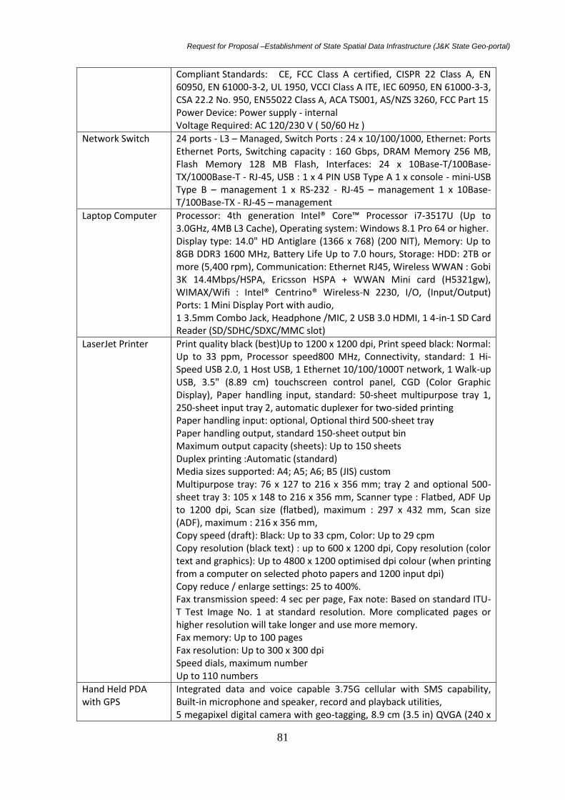
Request for Proposal –Establishment of State Spatial Data Infrastructure (J&K State Geo-portal)
81
Compliant Standards: CE, FCC Class A certified, CISPR 22 Class A, EN 60950, EN 61000-3-2, UL 1950, VCCI Class A ITE, IEC 60950, EN 61000-3-3, CSA 22.2 No. 950, EN55022 Class A, ACA TS001, AS/NZS 3260, FCC Part 15 Power Device: Power supply - internal Voltage Required: AC 120/230 V ( 50/60 Hz )
Network Switch 24 ports - L3 – Managed, Switch Ports : 24 x 10/100/1000, Ethernet: Ports Ethernet Ports, Switching capacity : 160 Gbps, DRAM Memory 256 MB, Flash Memory 128 MB Flash, Interfaces: 24 x 10Base-T/100Base-TX/1000Base-T - RJ-45, USB : 1 x 4 PIN USB Type A 1 x console - mini-USB Type B – management 1 x RS-232 - RJ-45 – management 1 x 10Base-T/100Base-TX - RJ-45 – management
Laptop Computer Processor: 4th generation Intel® Core™ Processor i7-3517U (Up to 3.0GHz, 4MB L3 Cache), Operating system: Windows 8.1 Pro 64 or higher. Display type: 14.0" HD Antiglare (1366 x 768) (200 NIT), Memory: Up to 8GB DDR3 1600 MHz, Battery Life Up to 7.0 hours, Storage: HDD: 2TB or more (5,400 rpm), Communication: Ethernet RJ45, Wireless WWAN : Gobi 3K 14.4Mbps/HSPA, Ericsson HSPA + WWAN Mini card (H5321gw), WIMAX/Wifi : Intel® Centrino® Wireless-N 2230, I/O, (Input/Output) Ports: 1 Mini Display Port with audio, 1 3.5mm Combo Jack, Headphone /MIC, 2 USB 3.0 HDMI, 1 4-in-1 SD Card Reader (SD/SDHC/SDXC/MMC slot)
LaserJet Printer
Print quality black (best)Up to 1200 x 1200 dpi, Print speed black: Normal: Up to 33 ppm, Processor speed800 MHz, Connectivity, standard: 1 Hi-Speed USB 2.0, 1 Host USB, 1 Ethernet 10/100/1000T network, 1 Walk-up USB, 3.5" (8.89 cm) touchscreen control panel, CGD (Color Graphic Display), Paper handling input, standard: 50-sheet multipurpose tray 1, 250-sheet input tray 2, automatic duplexer for two-sided printing Paper handling input: optional, Optional third 500-sheet tray Paper handling output, standard 150-sheet output bin Maximum output capacity (sheets): Up to 150 sheets Duplex printing :Automatic (standard) Media sizes supported: A4; A5; A6; B5 (JIS) custom Multipurpose tray: 76 x 127 to 216 x 356 mm; tray 2 and optional 500-sheet tray 3: 105 x 148 to 216 x 356 mm, Scanner type : Flatbed, ADF Up to 1200 dpi, Scan size (flatbed), maximum : 297 x 432 mm, Scan size (ADF), maximum : 216 x 356 mm, Copy speed (draft): Black: Up to 33 cpm, Color: Up to 29 cpm Copy resolution (black text) : up to 600 x 1200 dpi, Copy resolution (color text and graphics): Up to 4800 x 1200 optimised dpi colour (when printing from a computer on selected photo papers and 1200 input dpi) Copy reduce / enlarge settings: 25 to 400%. Fax transmission speed: 4 sec per page, Fax note: Based on standard ITU-T Test Image No. 1 at standard resolution. More complicated pages or higher resolution will take longer and use more memory. Fax memory: Up to 100 pages Fax resolution: Up to 300 x 300 dpi Speed dials, maximum number Up to 110 numbers
Hand Held PDA with GPS
Integrated data and voice capable 3.75G cellular with SMS capability, Built-in microphone and speaker, record and playback utilities, 5 megapixel digital camera with geo-tagging, 8.9 cm (3.5 in) QVGA (240 x

Request for Proposal –Establishment of State Spatial Data Infrastructure (J&K State Geo-portal)
82
320 pixel) LED Flash, Bluetooth® v2.0 wireless technology 802.11b/g + WAPI wireless LAN 3.5 inch QVGA sunlight-readable color touch screen Long-life, rechargeable, and removable Li-Ion battery 800 MHz processor, 256 MB RAM 2 GB flash memory2 GB built-in storage, 1 micro SD (micro SDHC compatible) memory card slot, Integrated speaker and microphone, Windows® Embedded Handheld 6.5 Professional in English, High-sensitivity GPS/SBAS1 receiver and antenna, Battery: 3060 mAh lithium-ion, rechargeable in unit, International AC power supply. Power: Low (no GPS, backlight on: 14 hours, Normal (with GPS and backlight on) 10 hours, Radios: Bluetooth v2.05, Wi-Fi 802.11b/g rated HSPA+ 3.75G cellular (data and voice
DC to AC Power Converter
Input 11-15 volt DC, Output 220 volts AC

Request for Proposal –Establishment of State Spatial Data Infrastructure (J&K State Geo-portal)
83
SPECIFICATIONS OF THE HARDWARE ACCESSORIES
Online UPS with 6 Hour Backup System
Brand & Model TSP to Provide
Component Specifications
UPS Type On-Line UPS 10 KVA, Back-Uptime: 6 Hours, with isolation
transformer suitable for Three Phase AC Input and Three Phase AC
Output, Floor, Mounted Type. High availability true on-line double
conversion (12V, SMF Battery), with battery stand (covered)
With dual feed input for hot standby configuration
Backup 6 Hours
Rectifier IGBT
Input voltage 380/400/415V 3 phase
Input frequency 50 / 60 Hz, Customer can opt for 50 Hz or 60 Hz.
Output voltage 380/400/415V 3 phase
Output Power Factor 0.9
Input power factor at rated load. >/= 0.99
Voltage recovery time < 20 m/sec.
Crest factor 3 : 1
Overload @ 0.9 P.F 125% for 10 minutes, 150% for 1 min, 168% for 5 sec
Noise level </= 50 dBA
Bypass frequency tolerance +/- 2%
D.C operating voltage range 480V ± 15%
Relative Humidity 95% non-condensing
Other features Cold Start
Smart Eco mode
Static Bypass
Battery Management Standard
Active power factor correction
Advanced digital signal processor
Lightning and surge protection
Complete remote monitoring and control

Request for Proposal –Establishment of State Spatial Data Infrastructure (J&K State Geo-portal)
84
8x3 phase voltage stabilizer/improver
Brand TSP To Provide
Model TSP To Provide
Component Specifications
Servo motor operated line voltage correctors suitable for phase Voltage range 120 to 280 volts
Three phase, rated KVA: 3 x 10.0 KVA. Servo motor operated line voltage correctors copper
wound, indoor type, continuous duty, suitable for phase voltage of 120-280 volts. Three phase
line voltage correctors shall comprise of three single phase line voltage correctors conforming to
IS:9815 (Pt.1/1994( Reaffirmed 2004) connected in star and enclosed in a single enclosure with
common control panel and shall be suitable for unbalance input voltage. Rated output voltage
shall be 240 V for single phase LVC and 415 V for three phase LVC respectively.
30 KVA Diesel Genset
Brand TSP To Provide
Model TSP To Provide
Component Specifications
Diesel Generating Sets with AMF Control Panel
Rated Voltage(in Volts): 415 3 Phase
No. of Phases: Three
Type of Engine Cooling: Water
Rated Capacity (in KVA): 30
Comprising of Liquid Cooled
Diesel Engine coupled Alternator
Mounted on a common M. S. Channel base frame including Fuel Tank, Standard Control Panel,
and Battery with leads canopy and accessories.

Request for Proposal –Establishment of State Spatial Data Infrastructure (J&K State Geo-portal)
85
SECTION 7
Standard Form of Contract
CONTRACT FOR
Establishment of State Spatial Data Infrastructure (J&K State Geo-portal)
TSPS SERVICES - Lump-Sum Contract
Between
Department of Ecology, Environment & Remote Sensing, Govt. of Jammu & Kashmir
And
[Name of the TSP]
Dated:
Establishment of State Spatial Data Infrastructure (J&K State Geo-portal)

Request for Proposal –Establishment of State Spatial Data Infrastructure (J&K State Geo-portal)
86
CONTRACT
Between
Department of Ecology, Environment & Remote Sensing, J&K Govt., Srinagar
and
(Name of the TSP)
Logo of the TSP

Request for Proposal –Establishment of State Spatial Data Infrastructure (J&K State Geo-portal)
87
1. FORM OF CONTRACT
This contract
“ESTABLISHMENT OF STATE SPATIAL DATA INFRASTRUCTURE (J&K STATE GEO-PORTAL)”
(Hereinafter called the services) is made the [day] day of the month of [month], [year], between the
Department of Ecology, Environment & Remote Sensing of Jammu & Kashmir Government (hereinafter
called DEARS) and (name of the TSP), (hereinafter called TSP).
DEARS shall mean the Jammu & Kashmir Govt. represented by any person or agency authorized to act on
behalf of DEARS (Department of Ecology, Environment & Remote Sensing, Government of Jammu & Kashmir,
DEARS Office complex, SDA Colony, Bemina, Srinagar, Kashmir (J&K)
TSP shall mean……………………………………………… and having its Registered Office……………………………………… with
whom or with which the order for setting up of Web Portal at the DEARS campus, Bemina, Srinagar shall be
deemed to include its successors, assigned representatives, heirs, executors and administrators unless
excluded by this agreement.
[Note: If the TSP consists of more than one entity, the above should be partially amended to read as
follows: ….(hereinafter called the _________ and, on the other hand, a joint venture/
consortium/association consisting of the following entities, each of which will be jointly and severally
liable to the DEARS for all the TSP’s obligations under this Contract, namely, [name of TSP] and
[name of TSP] (hereinafter called the TSP).]
WHEREAS
DEARS has requested TSP to provide certain consulting services as defined in this Contract
(hereinafter called the Services);
DEARS has selected TSP through a process of open-transparent competitive tender process to
provide the services for “Establishment of State Spatial Data Infrastructure (J&K State Geo-portal)”
as defined in this Contract (hereinafter called the “Services”);
TSP, having represented to DEARS that it has the required professional skills, personnel and technical
resources, has agreed to provide the Services on the terms and conditions set forth in this contract
and as per the RFP.
NOW THEREFORE the parties hereto hereby agree as follows:
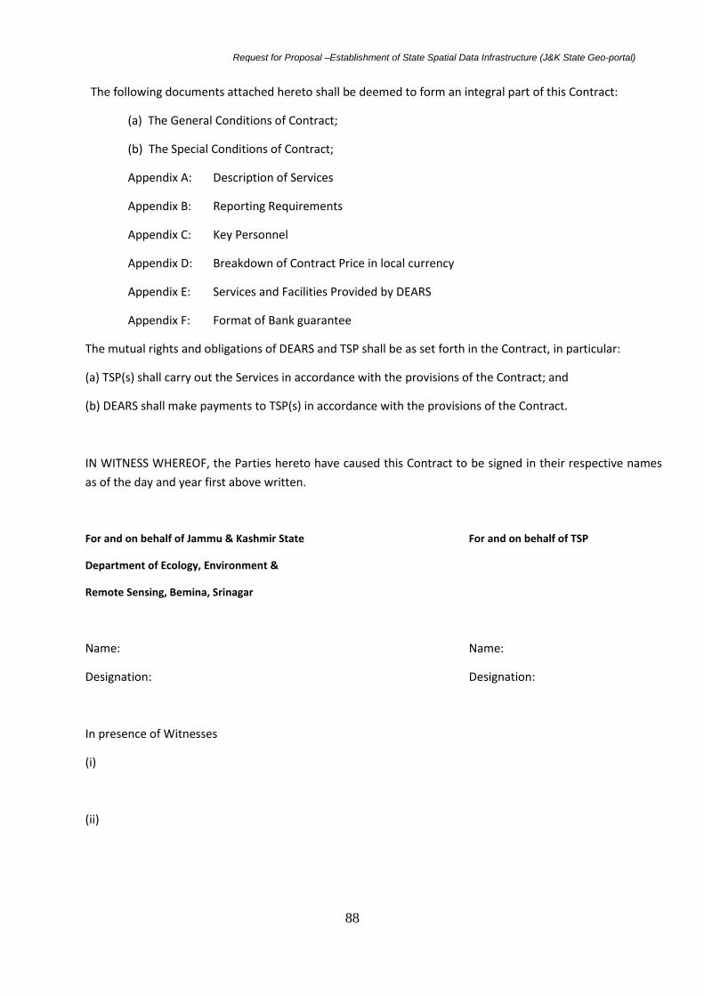
Request for Proposal –Establishment of State Spatial Data Infrastructure (J&K State Geo-portal)
88
The following documents attached hereto shall be deemed to form an integral part of this Contract:
(a) The General Conditions of Contract;
(b) The Special Conditions of Contract;
Appendix A: Description of Services
Appendix B: Reporting Requirements
Appendix C: Key Personnel
Appendix D: Breakdown of Contract Price in local currency
Appendix E: Services and Facilities Provided by DEARS
Appendix F: Format of Bank guarantee
The mutual rights and obligations of DEARS and TSP shall be as set forth in the Contract, in particular:
(a) TSP(s) shall carry out the Services in accordance with the provisions of the Contract; and
(b) DEARS shall make payments to TSP(s) in accordance with the provisions of the Contract.
IN WITNESS WHEREOF, the Parties hereto have caused this Contract to be signed in their respective names
as of the day and year first above written.
For and on behalf of Jammu & Kashmir State For and on behalf of TSP
Department of Ecology, Environment &
Remote Sensing, Bemina, Srinagar
Name: Name:
Designation: Designation:
In presence of Witnesses
(i)
(ii)

Request for Proposal –Establishment of State Spatial Data Infrastructure (J&K State Geo-portal)
89
General Conditions of Contract
GENERAL PROVISIONS
The TSP, subject to this Contract, has complete charge of Personnel and Sub-TSP, if any, performing
the Services and shall be fully responsible for the Services performed by them or on their behalf
hereunder.
1.1. Law Governing Contract This Contract, its meaning and interpretation, and the relation
between the Parties shall be governed by the Applicable Law in the State of Jammu and
Kashmir.
1.2. Headings: The headings shall not limit, alter or affect the meaning of this Contract
1.3. Language This Contract has been executed in English, which shall be the binding and
controlling language for all matters relating to the meaning or interpretation of this
Contract.
1.4. Notices
1.4.1. At the respective addresses set forth above or such other addressed and to the
attention of such other person or persons as may hereafter be designated by like notice
hereunder, and any such notice sent by post shall be deemed to have been served on the
date when, in the ordinary course of post, it would have been delivered at the address to
which it was sent.
1.4.2. Any notice, request or consent required or permitted to be given or made pursuant to
this Contract shall be in writing in the English language and shall be given by mailing the
same by Speed Post, registered airmail, postage prepaid, In the case of the Employer, to:
JAMMU & KASHMIR GOVERNMENT
through
(Department of Ecology, Environment & Remote Sensing, Government of Jammu &
Kashmir) SDA Housing Colony, Bemina, Srinagar, Jammu & Kashmir State-190018
Tel/Fax:0194-2490823
E mail: [email protected]
Web site: jkdears.com
and in the case of TSP, To:
TSP’s detailed address
Authorized signatory
Name and designation

Request for Proposal –Establishment of State Spatial Data Infrastructure (J&K State Geo-portal)
90
Attention:
A Party may change its address for notice hereunder by giving the other Party notice in writing of
such change to the address specified in the Contract.
1.5. Location: The Location shall mean, the location identified in the Office of the DEARS. The
Services shall be performed at such locations as are specified the document and, where the location
of a particular task is not so specified, at such locations, as the Employer may approve.
1.6. Authority of Lead Partner: In case the TSP consists of a joint venture/ consortium/ association
of more than one entity, the members hereby authorize the entity specified in the section to act on
their behalf in exercising all the TSP’s rights and obligations towards the Employer under this
Contract, including without limitation the receiving of instructions and payments from the Employer.
1.7. Authorized Representatives: Any action required or permitted to be taken, and any document
required or permitted to be executed under this Contract by the Employer or the TSP may be taken
or executed by the officials specified in the Contract.
1.8. Taxes and Duties: The TSP, Sub-TSP(s), and their personnel shall pay such taxes, duties, fees,
and other impositions levied under the applicable law as specified in the Section, the amount of
which is deemed to have been included in the Contract Price.
1.9. Fraud and Corruption
Definitions: It is the employer’s policy to require that this Contract observe the highest
standard of ethics during the selection and execution of such Contracts. In pursuance of this
policy, the employer defines, for the purpose of this provision, the terms set forth below as
follows:
(i) Corrupt practice means the offering, receiving, or soliciting, directly or indirectly,
of anything of value to influence the action of a public official in the selection
process or in Contract execution;
(ii) Fraudulent practice means a misrepresentation or omission of facts in order to
influence a selection process or the execution of a Contract;
iii) Collusive practices mean a scheme or arrangement between two or more TSP(s),
with or without the knowledge of the borrower, designed to establish prices at
artificial, noncompetitive levels;
(iv) coercive practices means harming or threatening to harm, directly or indirectly,
persons or their property to influence their participation in a procurement process,
or affect the execution of a Contract;
1.10. Measures to be taken
The DEARS will blacklist/sanction a TSP, including declaring the TSP ineligible, either indefinitely or
for a stated period of time, to be awarded a Contract if it at any time determines that the TSP has,
directly or through an agent, engaged incorrupt, fraudulent, collusive or coercive practices in
competing for, or in executing, a Contract;
a) The Employer may terminate the contract if it determines at any time that representatives of the
TSP were engaged in corrupt, fraudulent, collusive or coercive practices during the selection process

Request for Proposal –Establishment of State Spatial Data Infrastructure (J&K State Geo-portal)
91
or the execution of that contract, without the TSP having taken timely and appropriate action
satisfactory to the Employer to remedy the situation;
b) The Employer may also sanction against the TSP, including declaring the TSP ineligible, either
indefinitely or for a stated period of time, to be awarded a contract if it at any time determines that
the TSP has, directly or through an agent, engaged in corrupt, fraudulent, collusive or coercive
practices in competing for, or in executing, an Employer-financed contract;
1.11. Commissions and Fees
At the time of execution of this Contract, the TSP shall disclose any commissions or fees that may
have been paid or are agreed to be paid to agents, representatives, or commission agents with
respect to the selection process or execution of the contract.
The information disclosed must include at least the name and address of the agent, representative,
or commission agent, the amount and currency, and the purpose of the commission or fee.
2.1 1. Definitions: Unless the context otherwise requires, the following terms whenever used in this
Contract have the following meanings:
(a) Applicable Law means the laws and any other instruments having the force of law in
State of Jammu and Kashmir for the time being.
(b) TSP means any Company/firm/proprietor or public entity that will provide the Services to
the Employer under the Contract.
(c) Contract means the Contract signed by the Parties and all the attached documents listed
in its Clause 1.
(d) Day means calendar day.
(e) Effective Date means the date on which this Contract comes into force.
(f) Government means the Government of Jammu & Kashmir
(g) Currency means Indian Rupees.
(h)Member means any of the entities that make up the joint
venture/consortium/association; and Members means all these entities.
(i) Party means the Employer or the TSP, as the case may be, and Parties means both of
them.
(j) Personnel mean professionals and support staff provided by the TSP or by any Sub-TSP
and assigned to perform the Services or any part thereof.
(k) Reimbursable expenses mean all assignment-related costs [such as travel, translation,
report printing, secretarial expenses, subject to specified maximum limits in the Contract].
(l) Services means the work to be performed by the TSP pursuant to this Contract (m) Sub-
TSP means any person or entity with whom the TSP jointly bid for the Services.
(n) Third Party means any person or entity other than the Employer, or the TSP.
(o) In writing means communicated in written form with proof of receipt.

Request for Proposal –Establishment of State Spatial Data Infrastructure (J&K State Geo-portal)
92
2. COMMENCEMENT, COMPLETION, MODIFICATION & TERMINATION OF CONTRACT
2.1 Effectiveness of Contract: This Contract shall come into effect on the date the Contract is signed
by both parties and such other later date as may be stated in the SC. The date the Contract comes
into effect is defined as the effective date.
2.2 Termination of Contract for Failure to Become Effective: If this Contract has not become
effective within such time period after the date of the Contract signed by the Parties as specified in
the SC, either Party may, by not less than twenty one (21) days written notice to the other Party,
declare this Contract to be null and void, and in the event of such a declaration by either Party,
neither Party shall have any claim against the other Party with respect hereto.
2.3 Commencement of Services: The TSP shall begin carrying out the Services not later than the
number of days after the Effective Date specified in the Contract. Expiration of Contract unless
terminated earlier, this Contract shall expire at the end of such time period after the effective date
as specified in the Contract.
2.4 Expiration of Contract: Unless terminated earlier pursuant to Clause GC 2.6 in the Contract
hereof, this Contract shall expire at the end of such time period after the effective date as specified
in the SC.
2.5 Entire Agreement: This Contract contains all covenants, stipulations and provisions agreed by
the Parties. No agent or representative of either Party has authority to make, and the Parties shall
not be bound by or be liable for, any other statement, representation, promise or agreement not set
forth herein.
2.6 Modifications or Variations: Any modification or variation of the terms and conditions of this
Contract, including any modification or variation of the scope of the services, may only be made by
written agreement between the parties. However, each party shall give due consideration to any
proposals for modification or variation made by the other party.
2.7. FORCE MAJEURE
2.5.1 Definition
(a) For the purposes of this Contract, Force Majeure means an event which is beyond the reasonable
control of a Party, is not foreseeable, is unavoidable and not brought about by or at the instance of
the Party claiming to be affected by such events and which has caused the non-performance or
delay in performance, and which makes a Party’s performance of its obligations hereunder
impossible or so impractical as reasonably to be considered impossible in the circumstances, and
includes, but is not limited to, war, riots, civil disorder, earthquake, fire, explosion, storm, flood or
other extreme adverse weather conditions, strikes, lockouts or other industrial action (except where
such strikes, lockouts or other industrial action are within the power of the Party invoking Force
Majeure to prevent), confiscation or any other action by Government agencies.
(b) Force Majeure shall not include (i) any event which is caused by the negligence or intentional
action of a Party or by or of such Party’s Sub-TSP or agents or employees, nor (ii) any event which a
diligent Party could reasonably have been expected both to take into account at the time of the
conclusion of this Contract, and avoid or overcome in the carrying out of its obligations hereunder.

Request for Proposal –Establishment of State Spatial Data Infrastructure (J&K State Geo-portal)
93
(c) Subject to clause 2.7.2, Force Majeure shall not include insufficiency of funds or inability to make
any payment required hereunder.
2.5.2 Breach of Contract: The failure of a Party to fulfill any of its obligations under the Contract shall
not be considered to be a breach of, or default under, this Contract insofar as such inability arises
from an event of Force Majeure, provided that the Party affected by such an event (a) has taken all
reasonable precautions, due care and reasonable alternative measures in order to carry out the
terms and conditions of this Contract, and (b) has informed the other Party as soon as possible about
the occurrence of such an event.
2.5.3 Measures to be taken:
(a) A Party affected by an event of Force Majeure shall continue to perform its obligations under the
Contract as far as is reasonably practical, and shall take all reasonable measures to minimize the
consequences of any event of Force Majeure.
(b) A Party affected by an event of Force Majeure shall notify the other Party of such event as soon as possible, and in any case not later than fourteen (14) days following the occurrence of such event, providing evidence of the nature and cause of such event, and shall similarly give written notice of the restoration of normal conditions as soon as possible.
(c) Any period within which a Party shall, pursuant to this Contract, complete any action or task, shall
be extended for a period equal to the time during which such Party was unable to perform such
action as a result of Force Majeure.
(d) During the period of their inability to perform the Services as a result of an event of Force
Majeure, the TSP, upon instructions by the Employer, shall either: (i) demobilize,; or (ii) continue
with the Services to the extent possible, in which case the TSP shall continue to be paid
proportionately and on prorate basis, under the terms of this Contract.
(e) In the case of disagreement between the Parties as to the existence or extent of Force Majeure,
the matter shall be settled according to Clause GC 10.
2.5.4. Extension of Time: Any period within which a Party shall, pursuant to this Contract, complete
any action or task, shall be extended for a period equal to the time during which such Party was
unable to perform such action as a result of Force Majeure. Payments During the period of their
inability to perform the Services as a result of an event of Force Majeure, the TSP shall be entitled to
continue to be paid under the terms of this Contract.
2.5.6. Suspension: The Employer may, by written notice of suspension to the TSP, suspend all
payments to the TSP hereunder if the TSP fails to perform any of its obligations under this Contract,
including the carrying out of the Services, provided that such notice of suspension (i) shall specify the
nature of the failure, and (ii) shall allow the TSP to remedy such failure, if capable of being remedied,
within a period not exceeding thirty (30) days after receipt by the TSP of such notice of suspension.
2.6. TERMINATION OF CONTRACT
2.6.1. By the Employer: The Employer may terminate this Contract in case of the occurrence of any
of the events specified in paragraphs (a) through (f) of this Clause 2.6.1. In such an occurrence, the
Employer shall give a not less than thirty (30) days’ written notice of termination to the TSP, and
sixty (60) days’ in the case of the event referred to in (e).

Request for Proposal –Establishment of State Spatial Data Infrastructure (J&K State Geo-portal)
94
(a) If the TSP does not remedy a failure in the performance of their obligations under the Contract,
within thirty (30) days after being notified or within any further period as the Employer may have
subsequently approved in writing.
b) If the TSP becomes insolvent or bankrupt.
(c) If the TSP, in the judgment of the Employer has engaged in corrupt or fraudulent practices in
competing for or in executing the Contract.
(d) If, as the result of Force Majeure, the TSP are unable to perform a material portion of the
Services for a period of not less than sixty (60) days.
(e) If the Employer, in its sole discretion and for any reason whatsoever, decides to terminate this
Contract.
(f) If the TSP fails to comply with any final decision reached as a result of arbitration proceedings
pursuant to Clause GC 10 hereof.
2.6.2 By the TSP: The Bidders may terminate this Contract, by not less than thirty (30) days’ written notice to the Client, such notice to be given after the occurrence of any of the events specified in paragraphs (a) through (c) of this Clause GC 2.6.2: (a) If the Client fails to pay any money due to the Bidder pursuant to this Contract and not subject to dispute pursuant to Clause GC 7 hereof within forty five (45) days after receiving written notice from the Bidder that such payment is overdue. (b) If, as the result of Force Majeure, the Bidder is unable to perform a material portion of the Services for a period of not less than sixty (60) days. (c) If the Client fails to comply with any final decision reached as a result of arbitration pursuant to Clause GC 10 hereof. 2.6.3 Payment upon Termination Upon termination of this Contract pursuant to Clauses GC 2.6.1 or GC 2.6.2, the Client shall make the following payments to the Bidder: (a) Payment pursuant to Clause GC 6 for Services satisfactorily performed prior to the effective date of termination; (b) Except in the case of termination pursuant to paragraphs (a) through (c), and (f) of Clause GC. 2.6.1, reimbursement of any reasonable cost incident to the prompt and orderly termination of the Contract, including the cost of the return travel of the Personnel and their eligible dependents.
3.0. OBLIGATIONS OF THE TSP
3.1 GENERAL
3.1.1 Standard of Performance: The TSP shall perform the services and carry out their obligations
hereunder with all due diligence, efficiency and economy, in accordance with generally accepted
professional standards and practices, and shall observe sound management practices and employ
appropriate technology and safe and effective equipment, machinery, materials and methods. The
TSP shall always act, in respect of any matter relating to this Contract or to the Services, as faithful
advisers to the Employer, and shall at all times support and safeguard the Employer’s legitimate
interests in any dealings with Sub-TSP(s) or third parties.

Request for Proposal –Establishment of State Spatial Data Infrastructure (J&K State Geo-portal)
95
3.2 Conflict of Interests: The TSP shall hold the Employer’s interests paramount, without any
consideration for future work, and strictly avoid conflict with other assignments or their own
corporate interests.
3.2.1 TSPs Not to Benefit from Commissions, Discounts, etc:
The payment of the TSP pursuant to Clause GC 6 hereof shall constitute the TSP’s only payment in
connection with this Contract and, subject to Clause GC 3.2.2 hereof, the TSP shall not accept for its
own benefit any trade commission, discount or similar payment in connection with activities
pursuant to this Contract or in the discharge of its obligations hereunder, and the TSP shall use its
best efforts to ensure that any Sub-TSP, as well as the Personnel and agents of either of them,
similarly shall not receive any such additional payment.
Furthermore, if the TSP, as part of the Services, has the responsibility of advising the Employer on
the procurement of goods, works or services, the TSP shall comply with the Employer’s applicable
procurement guidelines, and shall at all times exercise such responsibility in the best interest of the
Employer. Any discounts or commissions obtained by the TSP in the exercise of such procurement
responsibility shall be for the account of the Employer.
3.2.2. TSP and Affiliates not to Engage in Certain Activities: The TSP agrees that, during the term of
this Contract and after its termination, the TSP and any entity affiliated with the TSP, as well as any
Sub-TSP(s) and any entity affiliated with such Sub-TSP(s), shall be disqualified from providing goods,
works or services (other than consulting services and goods / equipment specified in the TOR)
resulting from or directly related to the TSP’s services for the preparation or implementation of the
project.
3.2.3. Prohibition of Conflicting Activities: The TSP shall not engage, and shall cause their personnel
as well as their Sub-TSP(s) and their Personnel not to engage, either directly or indirectly, in any
business or professional activities which would conflict with the activities assigned to them under
this Contract.
3.3. Confidentiality: Except with the prior written consent of the Employer, the TSP and the
personnel shall not at any time communicate to any person or entity any confidential information
acquired in the course of the services, nor shall the TSP and the personnel make public the
recommendations formulated in the course of, or as a result of, the services.
3.4. Insurance to be taken out by the TSP: The TSP (a) shall take out and maintain, and shall cause
any Sub-TSP(s) to takeout and maintain, at their (or the Sub-TSP(s)’, as the case may be) own cost
but on terms and conditions approved by the Employer, insurance against the risks, and for the
coverage, as shall be specified in the Section; and (b) at the Employer’s request, shall provide
evidence to the Employer showing that such insurance has been taken out and maintained and that
the current premiums have been paid.
3.5. TSP’s Actions Requiring Employer’s Prior Approval: The TSP shall obtain the Employer’s prior
approval in writing before taking any of the following actions: (a) Any change or addition to the
Personnel listed in Appendix C. (b) Subcontracts: the TSP may subcontract work relating to the
Services to an extent and with such experts and entities as may be approved in advance by the
Employer. Notwithstanding such approval, the TSP shall always retain full responsibility for the
Services. In the event that any Sub-TSP is found by the Employer to be incompetent or incapable or
undesirable in discharging assigned duties, the Employer may request the TSP to provide a

Request for Proposal –Establishment of State Spatial Data Infrastructure (J&K State Geo-portal)
96
replacement, with qualifications and experience acceptable to the Employer, or to resume the
performance of the Services itself.
3.6. Reporting Obligations: The TSP shall submit to the Employer the reports and documents
specified in Appendix B hereto, in the form, in the numbers and within the time periods set forth in
the said Appendix. Final reports shall be delivered in CD ROM in addition to the hard copies specified
in said Appendix.
3.7. Documents Prepared by the TSP to be the Property of the Employer: All plans, drawings,
specifications, designs, reports, other documents and software prepared by the TSP for the
Employer under this Contract shall become and remain the property of the Employer, and the TSP
shall, not later than upon termination or expiration of this Contract, deliver all such documents to
the Employer, together with a detailed inventory thereof. The TSP may retain a copy of such
documents, but shall not use anywhere, without taking permission, in writing, from the Employer
and the Employer reserves right to grant or deny any such request. If license agreements are
necessary or appropriate between the TSP and third parties for purposes of development of any
such computer programs, the TSP shall obtain the Employer’s prior written approval to such
agreements, and the Employer shall be entitled at its discretion to require recovering the expenses
related to the development of the program(s) concerned.
3.8 Accounting, Inspection and Auditing:
The TSP
(i) shall keep accurate and systematic accounts and records in respect of the Services hereunder, in
accordance with internationally accepted accounting principles and in such form and detail as will
clearly identify all relevant time changes and costs, and the bases thereof, and
(ii) shall periodically permit the Employer or its designated representative and/or the Employer, and
up to five years from expiration or termination of this Contract, to inspect the same and make copies
thereof as well as to have them audited by auditors appointed by the Employer or the Employer, if
so required by the Employer or the Employer as the case may be.
4. TSP’S PERSONNEL AND SUB-TSP
4.1. Description of Personnel:
(a) The TSP shall employ and provide such qualified and experienced Personnel and Sub-TSP as are
required to carry out the Services. The title, agreed job description, minimum qualification and
estimated period of engagement in the carrying out of the Services of each of the TSP’s Key
Personnel are as per the TSP’s proposal and are described in Appendix C. If any of the Key Personnel
has already been approved by the Employer, his/her name is listed as well.
(b) If required to comply with the provisions of Clause GC 3.1.1 hereof, adjustments with respect to
the estimated periods of engagement of Key Personnel set forth in Appendix C may be made by the
TSP by written notice to the Employer, provided (i) that such adjustments shall not alter the
originally estimated period of engagement of any individual by more than 10% or one week,
whichever is larger, and (ii) that the aggregate of such adjustments shall not cause payments under
this Contract to exceed the ceilings set forth in Clause GC 6.1(b) of this Contract. Any other such
adjustments shall only be made with the Employer’s written approval.
(c) If additional work is required beyond the scope of the Services specified in Appendix A, the
estimated periods of engagement of Key Personnel set forth in Appendix C may be increased by

Request for Proposal –Establishment of State Spatial Data Infrastructure (J&K State Geo-portal)
97
agreement in writing between the Employer and the TSP. In case where payments under this
Contract exceed the ceilings set forth in Clause GC 6.1(b) of this Contract, this will be explicitly
mentioned in the agreement.
4.2. Approval of Personnel:
The Key Personnel and Sub-TSP listed by title as well as by name in Appendix C are hereby approved
by the Employer. In respect of other Personnel which the TSP proposes to use in the carrying out of
the Services, the TSP shall submit to the Employer for review and approval a copy of their Curricula
Vitae (CVs). If the Employer does not object in writing (stating the reasons for the objection) within
twenty-one (21) days from the date of receipt of such CVs, such Personnel shall be deemed to have
been approved by the Employer.
4.3. Removal and/or Replacement of Personnel:
(a) Except as the Employer may otherwise agree, no changes shall be made in the Key Personnel. If,
for any reason beyond the reasonable control of the TSP, such as retirement, death, medical
incapacity, among others, it becomes necessary to replace any of the Key Personnel, the TSP shall
provide as a replacement a person of equivalent or better qualifications.
(b) If the Employer finds that any of the Personnel have (i) committed serious misconduct have been
charged with having committed a criminal action, or (ii) have reasonable cause to be dissatisfied
with the performance of any of the Personnel, then the TSP shall, at the Employer’s written request
specifying the grounds thereof, provide as a replacement a person with qualifications and
experience acceptable to the Employer.
(c) The TSP shall have no claim for additional costs arising out of or incidental to any removal and/or
replacement of Personnel.
4.4 Resident Project Manager: If required by the Service Contract, the TSP shall ensure that at all
times during the TSP’s performance of the Services a resident project manager, acceptable to the
Employer, shall take charge of the performance of such Services.
5.0 OBLIGATIONS OF THE EMPLOYER
5.1 Assistance and Exemptions: Unless otherwise specified in the Service Contract, the Employer
shall use its best efforts to ensure that the Government shall:
(a) Provide the TSP, Sub-TSP and Personnel with work permits and such other documents as shall be
necessary to enable the TSP, Sub-TSP or Personnel to perform the Services.
(b) Issue to officials, agents and representatives of the Government all such instructions as may be
necessary or appropriate for the prompt and effective implementation of the Services.
(c) Provide to the TSP, Sub-TSP and Personnel any such other assistance as may be specified in the
Service Contract.
5.2 Change in the applicable law related to taxes and duties: If, after the date of this Contract,
there is any change in the applicable law with respect to taxes and duties which increases or
decreases the cost incurred by the TSP in performing the services, then the remuneration and
reimbursable expenses otherwise payable to the TSP under this Contract shall be increased or

Request for Proposal –Establishment of State Spatial Data Infrastructure (J&K State Geo-portal)
98
decreased accordingly by agreement between the parties, and corresponding adjustments shall be
made to the amounts referred to in Clauses GC 6.2 (a) or (b), as the case may be.
5.3 Services and Facilities:
(a) The Employer shall make available free of charge to the TSP the services and facilities listed under
Appendix E.
(b) In case that such services, facilities and property shall not be made available to the TSP as and
when specified in Appendix E, the Parties shall agree on any time extension that it may be
appropriate to grant to the TSP for the performance of the Services.
5.4 Payment:
In consideration of the Services performed by the TSP under this Contract, the “Employer” shall
make to the TSP such payments and in such manner as is provided by Clause GC 6 of this Contract.
5.5 Counterpart Personnel:
(a) If necessary, the “Employer” shall make available to the TSP free of charge such professional and
support counterpart personnel, to be nominated by the “Employer” with the TSP’s advice, if
specified in Appendix E.
(b) Professional and support counterpart personnel, excluding Employer’s liaison personnel, shall
work under the exclusive direction of the TSP. If any member of the counterpart personnel fails to
perform adequately any work assigned to such member by the TSP that is consistent with the
position occupied by such member, the TSP may request the replacement of such member, and the
“Employer” shall not unreasonably refuse to act upon such request.
6.0 PAYMENTS TO THE TSP
6.1 Total cost of Services:
a. The total payment due to the Bidder shall not exceed the Contract Price which is an all-inclusive
fixed lump-sum covering all costs required to carry out the services as outlined in section 5. The
hardware and software requirements are given in the Annexure I.
b. The Contract value is without any escalation till the period of the agreement.
c. The Contract value includes visits to the DEARS for purposes of the project, service Tax and other
duties and levies.
6.2 Currency of Payment: All payments shall be made in Indian Rupees. [In case the payment is to be
made in the currency other that Indian Rupees, the same shall be mentioned instead of Indian
Rupees]
6.3 Terms and Conditions of Payment: The payments in respect of the Services shall be made as
follows:
(a) The TSP shall submit the invoice for payment when the payment is due as per the agreed terms.
The payment shall be released as per the payment schedule of Paragraph 6.4 of this section.
(b) Once a milestone is completed, the TSP shall submit the requisite deliverables as specified in this
Contract. The Employer shall release the requisite payment upon acceptance of the deliverables.
However, if the Employer fails to intimate acceptance of the deliverables or its objections thereto,

Request for Proposal –Establishment of State Spatial Data Infrastructure (J&K State Geo-portal)
99
within 30 days of receipt of it, the Employer shall release the payment to the TSP without further
delay.
(d) For the purpose of payment under Clause 6.3 (b) above, acceptance means; acceptance of the
deliverables by the Employer after submission by the TSP and the TSP has made presentation to the
EC.
(e) If the deliverables submitted by the TSP are not acceptable to the Employer/ EC, reasons for such
non-acceptance should be recorded in writing; the Employer shall not release the payment due to
the TSP. This is without prejudicing the Employer’s right to levy any liquidated damages under clause
8. In such case, the payment will be released to the TSP only after it re-submits the deliverable and
which is accepted by the Employer.
6.4 Payment Schedule:
For making g any payment, the TSP has to submit an invoice to the Employer specifying the amount
due The Employer on receipt of invoice would make all payments to the TSP within 45 (Forty Five)
days from the date of receipt in the office of the DEARS.
The security deposit will be released after the final deployment and successful tests. Payment term
will follow the following schedule:
i. 60% on supply and installation of required hardware and software
ii. 35% on Migrating GIS Data into RDBMS and Creation of centralized database, publishing
metadata in the Geo-portal, total system integration, final deployment and
operationalization of the entire system, development of applications/customization
and training of JK SSDI project staff.
iv. 05% on successful reinstallation of the Hardware, Software, networking and re-
operationalization of Geoportal in the new building complex to be constructed for of
SSDI-JK in the existing office campus or after 2 years of successful installation whichever
is later.
6.5 Interest on Delayed Payments
If the Employer has delayed payments beyond forty five (45) days after the due date without stating
the reasons, interest at the prevailing bank rate shall be paid to the TSP for each day of delay.
7.0 GOVERNING LAW & ARBITRATION
Both Employer and TSP consent to the application of the laws applicable in J&K State to govern,
interpret, and enforce all of Employer’s and TSP’s rights, duties and obligations arising from, or
relating in any manner to, the subject matter of this Agreement, without regard to conflict of law
principles. The courts of law at Srinagar shall have the exclusive jurisdiction for matters relating to
this Agreement. Disputes arising out of or in connection with this Agreement shall be finally settled
by arbitration which shall be held in Srinagar J&K State, India in accordance with the laws applicable
in J&K State that are then in existence. The arbitration award shall be final and binding for the
parties without appeal and shall be in writing and set forth the findings of fact and the conclusions of
law. The number of arbitrators shall be three, with each side to the dispute being entitled to appoint
one arbitrator. The two arbitrators appointed by the parties shall appoint a third arbitrator who shall
act as chairman of the proceedings. The Secretary to Govt. of J&K Forest Department shall fill

Request for Proposal –Establishment of State Spatial Data Infrastructure (J&K State Geo-portal)
100
vacancies in the post of Chairman. The respective nominating party shall fill other vacancies.
Proceedings shall continue from the stage they were at when the vacancy occurred. If one of the
parties refuses or otherwise fails to appoint an arbitrator within 30 days of the date the other party
appoints its, the first appointed arbitrator shall be the sole arbitrator, provided that the arbitrator
was validly and properly appointed.
8.0 LIQUIDATED DAMAGES CLAUSE
If setting up of Geoportal is delayed beyond the stipulated time limit subject to force Majeure clause
(or any Supplement accepted by TSP pursuant to this Agreement)
a) The TSP shall pay the Employer, as fixed and agreed liquidated damages at the rate of 0.5% of the
Contract value per week of delay or part thereof, subject to a maximum of 5% of the Contract value.
b) In case the TSP fails to execute the Contract, the DEARS shall have the right to get the work
executed by another Agency in which case the TSP shall be liable to pay the additional amount spent
by the DEARS over and above the Contract value agreed upon by the TSP and in addition 10% extra
thereon towards indirect expenses.
c) In case TSP after drawing the payment, fails to execute the balance work under the Contract TSP
shall refund the payment of Contract value drawn by them together with interest @ 24% per annum.
Thereupon the condition as specified above shall apply automatically.
d) In case of default on the part of TSP to comply with any terms and conditions of the Contract the
(Head of the DEARS) at his discretion may forfeit the Security Deposit.
9.0 FAIRNESS AND GOOD FAITH
9.1 Good Faith: The Parties undertake to act in good faith with respect to each other’s rights under
this Contract and to adopt all reasonable measures to ensure the realization of the objectives of this
Contract.
9.2 Operation of the Contract: The Parties recognize that it is impractical in this Contract to provide
for every contingency which may arise during the life of the Contract, and the Parties hereby agree
that it is their intention that this Contract shall operate fairly as between them, and without
detriment to the interest of either of them, and that, if during the term of this Contract either Party
believes that this Contract is operating unfairly, the Parties will use their best efforts to agree on
such action as may be necessary to remove the cause or causes of such unfairness, but no failure to
agree on any action pursuant to this Clause shall give rise to a dispute subject to arbitration in
accordance with Clause GC 10 hereof.
10.0 SETTLEMENT OF DISPUTES
10.1 Amicable Settlement: Performance of the contract is governed by the terms & conditions of
the contract, in case of dispute arises between the parties regarding any matter under the contract,
either Party of the contract may send a written Notice of Dispute to the other party. The Party
receiving the Notice of Dispute will consider the Notice and respond to it in writing within 30 days
after receipt. If that party fails to respond within 30 days, or the dispute cannot be amicably settled
within 60 days following the response of that party, clause GC 10.2 shall become applicable.

Request for Proposal –Establishment of State Spatial Data Infrastructure (J&K State Geo-portal)
101
10.2 Arbitration: In the case of dispute arising upon or in relation to or in connection with the
contract between the Employer and the TSP, which has not been settled amicably, any party can
refer the dispute for Arbitration under (Indian) Arbitration and Conciliation Act, 1996. Such disputes
shall be referred to an Arbitral Tribunal consisting of 3 (three) arbitrators, one each to be appointed
by the Employer and the TSP, the third arbitrator shall be Secretary to Govt of J&K Forest
Department who will act as chairman of the proceedings and whose decision shall be binding on
both the parties. The Arbitration and Conciliation Act, 1996 and any statutory modification or re-
enactment thereof, shall apply to these arbitration proceedings.
10.3. Arbitration proceedings shall be held at Srinagar in J&K State and the language of the
arbitration proceedings and that of all documents and communications between the parties shall be
English.
10.4 The decision of the Secretary to Govt. of J&K Forest Department shall be final and binding upon
both parties. The expenses incurred by each party in connection with the preparation, presentation
shall be borne by the party itself. All arbitration awards shall be in writing and shall state the reasons
for the award.
11.0 DATA SECURITY
11.1 In the course of providing the Services, the TSP shall have to compile, process and store data at
the DEARS campus only and no data shall be given outside the DEARS campus. The TSP and each of
its users and employees designated for this project are responsible for complying with its respective
obligations under the applicable data protection laws and regulations in vogue.
11.2 The TSP is required to perform or adhere to only those security measures concerning the DEARS
data which were in place as of the date on which this Contract comes into force and effect and those
made available to it from time to time in accordance with the TOR.
11.3 Control of Databases: The control of the databases of the project will rest with DEARS.
11.4 Deployment of Geo-portal/ clearinghouse: The deployment of the Geoportal will be done by
TSP under the authority of DEARS.
11.5 Intellectual Property Rights: The DEARS will have all the IPR for the above mentioned
deliverables.
11.6 Documents Prepared by the TSP to be the property of the Employer:
All plans, drawings, specifications, designs, reports, other documents and software prepared by the
TSP for the Employer under this Contract shall become and remain the property of the Employer,
and the TSP shall, not later than upon termination or expiration of this Contract, deliver all such
documents to the Employer, together with a detailed inventory thereof.
11.7 Equipment and Materials Furnished by the Employer: Equipment and materials made available
to the TSP by the DEARS, or purchased by the TSP with funds provided by the DEARS, shall be the
property of the DEARS and shall be marked accordingly. Upon termination or expiration of this
Contract, the TSP shall make available to the DEARS) an inventory of such equipment and materials.

Request for Proposal –Establishment of State Spatial Data Infrastructure (J&K State Geo-portal)
102
12.0 PATENT INDEMNIFICATION CLAUSE
The TSP shall indemnify and keep indemnified the purchaser from and against any and all claims,
action, cost charges and expenses arising from or for infringement of patent rights, copy right and
other protected rights of any design, plans, diagrams drawings in respect of the stores supplied by
the TSP or any of the manufacturing methods or process adopted by the TSP for the stores supplied
under the Contract. In the event of any claim being made or action being brought against the
purchaser in respect of the matter referred above, the TSP shall promptly be notified thereof and he
shall at his own expense, conduct all negotiations for settlement of the same and any drawings,
plans or diagrams or any manufacturing methods or of patent or any other protected rights and use
thereof is at no costs to the latter, the rights to continue using the same or to the extent it is possible
to replace the same so as to avoid such infringement and subject to approval by the purchases or
modify them so that they become non-infringing but such modifications shall otherwise be to the
entire satisfaction of the purchaser. The provision of this clause shall remain effective and binding
upon the TSP even after the completion, expiration or termination of the Contract.
13.0 MAINTENANCE
TSP undertakes, subject to the terms and conditions stated in this agreement and supplement to this
agreement for Setting up of Geoportal.
(i) To provide and Maintenance services at the location for a period of one year from the date of
successful system integration and implementation.
(ii) To coordinate warranty services for procured equipment for a period of three year.
(iii) To provide technical assistance to the Employer both before and during installation and warranty
period
(v) To provide to the Employer on a continual basis all Software updates/ releases to the software
specified in Schedule hereto, as generally available, if any during warranty, free of cost.
14. INSTALLATION
14.1 TSP is responsible for the installation of the hardware, software, networking components and
any other component procured on the advice of the TSP under this Agreement. The Employer agrees
to permit TSP access to the Employer’s premises to execute the installation and other obligations
specified below.
14.2 The procured items/application software shall be installed in Jammu & Kashmir at the location
specified in this Agreement. TSP shall coordinate in installing the Equipment procured under this
Agreement in accordance with TSP specifications provided in the Tender documents.
15. ACCEPTANCE TESTS
15.1 The TSP shall prepare in consultation with Employer an Acceptance Test Plan and demonstrate
the functionality of the system. On approval of the Employer of the acceptance test plan, it shall be
binding on the TSP to provide all the technical assistance needed by the Employer to perform
Acceptance Test.
15.2 The acceptance test shall begin on the day following the day on which the system is installed, as
specified by TSP, and shall end after the acceptance tests are completed.

Request for Proposal –Establishment of State Spatial Data Infrastructure (J&K State Geo-portal)
103
15.3 The use of Geo Portal shall be under the Employer’s exclusive management and control. The
Employer is responsible for ensuring the proper use, management and supervision of the Equipment
and programs, audit controls, operating methods and office procedures, and for establishing all
proper checkpoints necessary for the Employer’s intended use of the system. TSP shall have no
obligations or liabilities for damages caused by the Employer’s failure to fulfill any of the Employer’s
responsibilities.
16. TRAINING
In order to help, use and manage/ maintain the complete system, 10 core Staff of JKSSDI are
required to be provided hands-on training of minimum 15 days duration at the DEARS Srinagar
campus to independently handle the Geo-portal and the available services. The TSP will provide
training manuals both in hard and soft copies to the Employer.
17.0 WARRANTIES
17.1 TSP warrants that System integrated & implemented and application software developed shall
be in good working orders on the date of installation, and that it shall conform to Employer’s
specifications. The warranty period for the System and Software extends for three years beyond the
successful integration and implementation of the services and on completion of the acceptance test.
The term warranty in this Agreement means the provision of warranty service as described in this
Agreement.
17.2 The TSP warrants that the design and development and application software developed have
been done by use of software packages and tools legally obtained and in the possession of the TSP.
17.3 The TSP warrants that there are no copyright and other associated violations in the design and
development of the application software. The TSP will further indemnify the Employer against any
third party initiating any legal action alleging violation of the copyright and other associated legal
rights.
18. DOCUMENTATION
Proper documentation shall be provided both as Hard and Soft Copies including that of Source Code,
Technical documents and Training manuals.
19. PERIOD OF AGREEMENT
This agreement will remain in force till the said scope of work has been completed in all respects.
The time for completion of works under this agreement is fixed as per the Project Execution
schedule. In case the work-time limit needs extension, the reasons for the request are to be
informed and prior consent is to be obtained from the Employer.
20. SECRECY
The technical information, drawings, specifications and related documents furnished by the
Employer to the TSP and forming part of the Agreement, are the properties of the Employer and
shall not be used for any other purpose, except for execution of the Agreement. All rights including
rights in the event of grant of patent and registration of designs are reserved. The said technical
information, drawings, specifications, records and other documents shall not be copied, transcribed,
traced or reproduced in any other form or otherwise in whole and or duplicated, modified, divulged
an or disclosed to a third party or misused in any other form whatsoever without Employer’s
consent in writing except to the extent required for the execution of this Agreement. This technical

Request for Proposal –Establishment of State Spatial Data Infrastructure (J&K State Geo-portal)
104
information, drawings, specifications and other related documents shall be returned to the
Employer with all approved copies and duplicates, if any, immediately after they have been used for
the agreed purpose. The TSP shall be at liberty to use ideas, concepts, know-how or techniques
related to processing system, which may be arising from or derived from the said technical
information, drawings, specifications and other related documents forming part of the Agreement.
21. PUBLICITY
No Publicity of any kind whatsoever regarding this Agreement shall be given by either party without
prior permission of the other party. The Employer and TSP acknowledge that they have read this
Agreement, understood it and agree to be bound by its terms and conditions. The parties agree that
this Agreement, together with any other applicable Agreements, certifications, amendments and
supplements and any exhibits or attachments thereto, referencing this Agreement or expressly
made a part hereof that are duly signed by the parties, supersede all proposals or prior Agreements,
oral or written and all other communications between the parties relating to the subject matter of
this Agreement.
22.0 LIMITATION OF REMEDIES
Subsequent to the acceptance of the system, TSP entire liability and the Employer’s exclusive
remedy shall be as follows:
22.1 In all situations involving performance or non-performance of equipment or programming
covered under this Agreement, the Employer’s remedy is (1) the adjustment or repair of the
equipment, or as required by the Employer depending upon the deficiency noticed with respect to
performance as per specifications, or corrections of programming errors, or (2) if, after repeated
efforts, TSP is unable to install the equipment, or a replacement Equipment, in good working order,
or to Equipment it to good working order, or to make programming operate, all as warranted, the
Employer shall be entitled to recover actual damages to the limits set forth in this Section.
22.2 TSP liability for direct damages to the Employer, for any cause whatsoever, and regardless of
form of action, shall be limited to the purchase price for the specific Equipment that caused the
damages or that are the subject matter of or are directly related to the cause of action.
22.3 In no event shall TSP be liable for any damages caused by the Employer’s failure to perform the
Employer’s responsibilities, or for any lost profits or savings or other consequential damages,
regardless of the form of action, whether in Contract or in tort, including negligence, even if TSP has
been advised of the possibility of such damages.
23. OTHER TERMS AND CONDITIONS
a. This Agreement is not assignable without the prior written consent of the other Party, which shall
not be unreasonably withheld. Except as otherwise provided in this Agreement, any other attempt
to assign any of the rights, duties or obligations shall be void. Any assignment by the Employer shall
be subject to the conditions of the Indian import license.
b. TSP shall perform the scope of work specified in the tender document including technical design &
architecture, ICT infrastructure planning (hardware, networking etc.), software development
(customization, application development, data warehousing, data mining, portal etc.), system
integration, warranty & post warranty operational maintenance obligations of this Agreement.
c. This Agreement can only be modified by a written agreement duly signed by persons authorized to
sign Agreement on behalf of the Employer and of TSP, and variations from, or addition to, the terms

Request for Proposal –Establishment of State Spatial Data Infrastructure (J&K State Geo-portal)
105
and conditions of this Agreement in any order or other written notification from the Employer or TSP
shall be of no effect.
d. Unless otherwise agreed to in writing by TSP, resale of equipment and / or programming by the
Employer outside of the Employer’s enterprise or shipment of equipment and / or programming
outside of India terminates TSP obligations under this Agreement.
e. It is the intention of the parties that unless the other party receives notice of claim within the said
three-year period, the claim shall be deemed to have been waived.
f. The Laws applicable in State of Jammu and Government shall govern this Agreement.
g. Supplemental agreements, amendments, terminations etc, any additions, supplements,
alterations, amendments etc. to the agreement shall be made as mutually agreed upon. Either party
may terminate the agreement by giving one month’s notice duly notifying the cause of action for the
termination or such termination shall be without prejudice to the right of claiming compensation by
either party for the bonafide expenditure already incurred or damages suffered pursuant to the
execution to the Contract.
h. Intending tenderers or their authorized representatives will be at liberty to be present at the time
of opening of tender on the specified date as given in this Tender Document. If the date fixed for
opening of the tender is declared to be a holiday, at a later date the tender will be opened at the
same time on the next working day following the holiday or holidays.
i. The Director DEARS reserves the right to choose, accept or reject any or all requests / offers, in full
or part, at any stage, reduce or increase the quantity without assigning any reasons thereof.
j. The Director DEARS further reserves the right to split the order among more than one tenderer if
considered necessary. The DEARS will not be responsible for any postal losses or delays in
submission of documents. The tender documents are nontransferable.
(k) Nothing contained in this Contract shall be construed as establishing or creating between the
Parties, a relationship of master and servant or principal and agent.
(l) The Contractor/TSP shall notify the Employer/ the Government of Jammu & Kashmir of any
material change in their status, in particular, where such change would impact on performance of
obligations under this Contract.
(m) Each member/constituent of the Contractor/TSP, in case of a consortium, shall be jointly and
severally liable to and responsible for all obligations towards the Employer/Government for
performance of works/services including that of its Associates/Sub Contractors under the Contract.
(n) The Contractor/TSP shall at all times indemnify and keep indemnified the Employer/Government
of Jammu & Kashmir against all claims/damages etc. for any infringement of any Intellectual
Property Rights (IPR) while providing its services under the Project.
(o) The Contractor/TSP shall at all times indemnify and keep indemnified the Employer/Government
of Jammu & Kashmir against any claims in respect of any damages or
compensation payable in consequences of any accident or injury sustained or suffered by its (the
Contractor’s/TSP’s) employees or agents or by any other third Party resulting from or by any action,
omission or operation conducted by or on behalf of the Contractor/TSP.
(q) All claims regarding indemnity shall survive the termination or expiry of the Contract.
Request for Proposal –Establishment of State Spatial Data Infrastructure (J&K State Geo-portal)
106
(r) It is acknowledged and agreed by all Parties that there is no representation of any type, implied
or otherwise, of any absorption, regularization, continued engagement or concession or preference
for employment of persons engaged by the (Contractor/TSP) for any engagement, service or
employment in any capacity in any office or establishment of the Government of Jammu & Kashmir
or the Employer.
IN WITNESS WHEREOF, the Employer and Bidder have caused this Agreement to be executed by
their duly authorized representatives as of the day and year first above written.
Accepted by Bidder for and on behalf of (the institution floating the RFP)
Authorized Signature Authorized Signature Name and Title Name and Title Seal Seal Date: Date:
Witnessed By:
1. 1.
2. 2.
Name and Title Name and Title
Date: Date:
[signature(s)] [signature(s)]

Request for Proposal –Establishment of State Spatial Data Infrastructure (J&K State Geo-portal)
107
Special Conditions of Contract
(Clauses in brackets { } are optional; all notes should be deleted in final text)
Number of GC Clause Amendments of, and Supplements to, Clauses in the General
Conditions of Contract {1.1(a)}
1.2 The language/s is English.
1.3 The addresses are:
Client: Department of Environment & Remote Sensing
SDA, colony Bemina, Srinagar, 190018 J&K,
Gladeni, Jammu-Srinagar J&K
E-mail: [email protected]
Bidder:
Attention:
Facsimile:
E-mail:
1.4 {The Member in Charge is [insert name of member]}
Note: If the Bidder consists of a joint venture/ consortium/ association of more than one entity, the
name of the entity whose address is specified in Clause SC 1.6 should be inserted here. If the Bidder
consists only of one entity, this Clause SC 1.4 should be deleted from the SC.
1.5. The Authorized Representatives are:
For the Client:
For the Bidder:
{2.1} {The Effective Date is [insert date].}
Note: The Effective Date may be specified by reference to conditions of effectiveness of the
Contract. If the Contract shall come into effect on the date it is signed, this
Clause SC 2.1 should be deleted from the SC.
2.2 The date for the commencement of Services is [insert date].
2.3 The time period shall be [insert time period, e.g.: twelve months].
2.4 The risks and the coverage shall be as follows:

Request for Proposal –Establishment of State Spatial Data Infrastructure (J&K State Geo-portal)
108
(a) Third Party motor vehicle liability insurance in respect of motor vehicles operated in the India by
the Bidder or its Personnel or any Sub-Bidders or their Personnel, with minimum coverage of [insert
amount and currency];
(b) Third Party liability insurance, with a minimum coverage of [insert amount and currency];
(c) Professional liability insurance, with a minimum coverage of [insert amount and currency];
(d) Employer’s liability and workers’ compensation insurance in respect of the
Personnel of the Bidder and of any Sub-Bidders, in accordance with the relevant
provisions of the Applicable Law, as well as, with respect to such Personnel, any such life, health,
accident, travel or other insurance as may be appropriate; and
(e) insurance against loss of or damage to (i) equipment purchased in whole or in part with funds
provided under this Contract, (ii) the Bidder’s property used in the performance of the Services, and
(iii) any documents prepared by the Bidder in the performance of the Services.
Note: Delete what is not applicable
{3.1 (c)} {The other actions are: [insert actions].}
Note: If there are no other actions, delete this Clause SC 3.1 (c).
{3.2 (b)} Note: If there is to be no restriction on the future use of these documents by either Party,
this Clause SC 3.2 should be deleted. If the Parties wish to restrict such use, any of the following
options, or any other option agreed to by the Parties, may be used:
{The Bidder shall not use these documents and software for purposes unrelated to this
Contract without the prior written approval of the Client.}
{The Client shall not use these documents and software for purposes unrelated to this
Contract without the prior written approval of the Bidder.}
{Neither Party shall use these documents and software for purposes unrelated to this
Contract without the prior written approval of the other Party.}
4.1 (a) The amount in local currency is [insert amount].
The accounts are: for local currency: [insert account]
4.2 The interest rate is: 12 %
4.3 Disputes shall be settled by arbitration in accordance with the following provisions:
1. Selection of Arbitrators. Each dispute submitted by a Party to arbitration shall be heard by a sole
arbitrator or an arbitration panel composed of three arbitrators, in accordance with the following
provisions:
(a) Where the Parties agree that the dispute concerns a technical matter, they may agree to appoint
a sole arbitrator or, failing agreement on the identity of such sole arbitrator within thirty (30) days
after receipt by the other Party of the proposal of a name for such an appointment by the Party who

Request for Proposal –Establishment of State Spatial Data Infrastructure (J&K State Geo-portal)
109
initiated the proceedings, either Party may apply to [name an appropriate professional body] for a
list of not fewer than five nominees and, on receipt of such list, the Parties shall alternately strike
names therefrom, and the last remaining nominee on the list shall be the sole arbitrator for the
matter in dispute. If the last remaining nominee has not been determined in this manner within sixty
(60) days of the date of the list, [insert the name of the same professional body as above] shall
appoint, upon the request of either Party and from such list or otherwise, a sole arbitrator for the
matter in dispute.
(b) Where the Parties do not agree that the dispute concerns a technical matter, the Client and the
Bidder shall each appoint one arbitrator, and these two arbitrators shall jointly appoint a third
arbitrator, who shall chair the arbitration panel. If the arbitrators named by the Parties do not
succeed in appointing a third arbitrator within thirty (30)days after the latter of the two arbitrators
named by the Parties has been appointed, the third arbitrator shall, at the request of either Party, be
appointed by [name an appropriate appointing authority;
(c) If, in a dispute subject to Clause SC 8.2 1.(b), one Party fails to appoint its arbitrator within thirty
(30) days after the other Party has appointed its arbitrator, the Party which has named an arbitrator
may apply to the [name the same appointing authority [as in Clause SC 8.2 1.(b)] to appoint a sole
arbitrator for the matter in dispute, and the arbitrator appointed pursuant to such application shall
be the sole arbitrator for that dispute.
2. Substitute Arbitrators. If for any reason an arbitrator is unable to perform his function, a
substitute shall be appointed in the same manner as the original arbitrator.
3. Nationality and Qualifications of Arbitrators. The sole arbitrator or the third arbitrator appointed
pursuant to paragraphs (a) through (c) of Clause SC 8.2 1 hereof shall be an internationally
recognized legal or technical expert with extensive experience in relation to the matter in dispute
and shall not be a national of the Bidder’s home country
(a) the country of incorporation of the Bidder [Note: If the Bidder consists of more than one entity,
add: or of any of their Members or Parties]; or
(b) the country in which the Bidder’s *or any of their Members’ or Parties’+ principal place of
business is located; or
(c) the country of nationality of a majority of the Bidder’s *or of any Members’ or
Parties’+ shareholders; or
(d) the country of nationality of the Sub-Bidders concerned, where the dispute involves a
subcontract.
5. Miscellaneous. In any arbitration proceeding hereunder:
(a) proceedings shall, unless otherwise agreed by the Parties, be held in [select a country which is
neither the Client’s country nor the Bidder’s country+;
(b) the English language shall be the official language for all purposes; and
(c) the decision of the sole arbitrator or of a majority of the arbitrators (or of the third arbitrator if
there is no such majority) shall be final and binding and shall be enforceable in any court of
competent jurisdiction, and the Parties hereby waive any objections to or claims of immunity in
respect of such enforcement.

Request for Proposal –Establishment of State Spatial Data Infrastructure (J&K State Geo-portal)
110
APPENDICES
(to be provided by TSP)

Request for Proposal –Establishment of State Spatial Data Infrastructure (J&K State Geo-portal)
111
APPENDIX- A – DESCRIPTION OF SERVICES
Give detailed descriptions of the Services to be provided, dates for completion of various tasks/activities, place of performance for different tasks, specific tasks/activities/outcome to be reviewed, tested and approved by “Employer”, etc.
APPENDIX B - REPORTING REQUIREMENTS
List format, frequency, and contents of reports; persons to receive them, dates of submission etc.
APPENDIX C – KEY PERSONNEL (STAFFINF SCHEDULE)
(Include here the agreed (negotiated staffing schedule including the engagement of subcontractors, if any) List under:
C-1 Titles [and names, if already available], detailed job descriptions and
minimum qualifications of Key Personnel to be assigned to work and estimated staff-months for each.
C-2 List of approved Sub-Bidders (if already available); same information
with respect to their Personnel as in C-1.
APPENDIX D – TOTAL COST OF SERVICES (Breakdown of contract price in local currency)
(Include here the rates quoted in the financial proposal or the negotiated rates, whichever is applicable)
APPENDIX E - SERVICES AND FACILITIES PROVIDED BY THE EMPLOYER
List here the services and facilities to make available to the Bidder by the Employer.
APPENDIX F - BANK GUARANTEE PROFORMA
BANK GUARANTEE PROFORMA FOR PERFORMANCE SECURITY
1. In consideration for the Govt. of Jammu & Kashmir having agreed to exempt ……. (hereinafter called
“the said Total Service Provider(s)” from the demand, under the terms and conditions of an Agreement
dated………………………made between ………………. and ……………….. of Performance Security for the due

Request for Proposal –Establishment of State Spatial Data Infrastructure (J&K State Geo-portal)
112
fulfillment of the said Service Provider of the terms and conditions contained in the said Agreement, on
production of Bank Guarantee for Rs………………………… (Rupees…… ………………………. (indicate the name of
the Bank) Bank”) at the request of …………………………………………. Service Provider do hereby undertake to
pay to the Government an amount not exceeding Rs………….. against any loss or damage caused to or
suffered would be caused to or suffered by the Government by reasons of any breach of the said
Service Provider of any of the terms or conditions contained in the said Agreement.
2. We……………………………… do hereby undertake to pay the amount due and payable under this Guarantee
without any demur, merely on a demand from the Government stating that the amount claimed is due
by way of loss or damage caused to or would be caused to or suffered by the Government by reason of
breach by the said Service Provider of any of the terms or conditions contained in the said Agreement
or by reason of the Service Provider’s failure to perform the said Agreement. Any such demand made
on the Bank shall be conclusive as regards the amount due and payable by the Bank under this
guarantee. However, our liability under this guarantee shall be restricted to an amount not exceeding
Rs…………
3. We undertake to pay the Government any money so demanded notwithstanding any dispute or
disputes raised by the Service Provider in any suit or proceeding pending before any Court or Tribunal
relating thereto liability under this present being absolute and unequivocal. The payment so made by us
under this Bond shall be a valid discharge of our liability for payment there under and the
contractor(s)/supplier(s) shall have no claim against us for making such payment.
4. We………………………………….. further agree that the guarantee herein contained shall remain in full force
and effect during the period that would be taken for the performance of the said Agreement and that it
shall continue to be enforceable till all the dues of the Government under or by virtue of the said
Agreement have been fully paid and its claim satisfied or discharged or till………………. that the terms and
conditions of the said Agreement have been fully and properly carried out by the said contractor(s) and
accordingly discharges this guarantee. Unless a demand or claim under this guarantee is made on us in
writing on or before the…… guarantee thereafter.
5. We ……………………………………. further agree with Government that the Government shall have the fullest
liberty without our consent and without affecting in any manner our obligations hereunder to vary any
of the terms and conditions of the said Agreement to extend time of performance by the said Service
Provider from time to time or to postpone for any time or from time to time any of the powers
exercisable by the Government against the said Service Provider and to forebear or enforce any of the
terms and conditions relating to the said Agreement and we shall not be relieved from our liability by
reason of any such variation, or extension being granted to the said Service Provider or for any
forbearance act or omission on the part of the Government to the said Service Provider or any
indulgence by the Government to the said Service Provider or by any such matter or this whatsoever
which under the law relating to sureties would, but for this provision, have effect of so relieving us.
6. Notwithstanding anything contained herein above our liability under the guarantee is restricted to
Rs……………………. and shall remain in force until………………. Unless a claim or suit under this guarantee is

Request for Proposal –Establishment of State Spatial Data Infrastructure (J&K State Geo-portal)
113
filed with us on or before ………………………… ALL OUR RIGHTS UNDER THE GUARANTEE SHALL BE
FORFEITED and the Bank shall be relieved and discharged from all liabilities therein.
7. This Guarantee will not be discharged due to the change in the constitution of the Bank or the Service
Provider.
8. We, ………………………….. lastly undertake not to revoke this Guarantee during its currency except with
the previous consent of the Government in writing. Dated the ………. date of……… 2013 for…………………..
(indicate the name of Bank)
Signature……………………………….
Name of the Officer………………………..
(in Block Capitals)
Designation of
Code No……………………………
Name of the Bank and Branch…………