REPORT TO Development Assessments Committee ITEM …
52
Mornington Peninsula Shire Council 1 REPORT TO Development Assessments Committee ITEM NO. 2.1.1 MEETING DATE Monday, 19 April, 2010 SUBJECT Application for Planning Permit – 435 Balnarring Road, Tuerong PREPARED BY Niall Sheehy, Acting Manager – Statutory Planning AUTHORISED BY Acting Director – Sustainable Environment FILE NO. 121225 ATTACHMENT(S) YES Application No. P09/0018 Proposal Proposed extractive industry and refuse disposal facility Melway Reference 152 D7 Zoning Green Wedge Zone Schedule 3 Applicant Grosvenor Lodge Pty Ltd Date Received 6 January, 2009 EXECUTIVE SUMMARY Proposal Use of the land for the purposes of a refuse disposal facility and extractive industry, construct and carry out works and remove native vegetation. Zoning Green Wedge Zone Schedule 3 (GWZ3). Abuts a Road Zone Category 1. Overlays • Environmental Significance Overlay – Schedule 3: Central Peninsula (ESO3); • Environmental Significance Overlay – Schedule 17: Streamlines (ESO17); and • Environmental Significance Overlay – Schedule 28: Mornington Peninsula Bushland (ESO28). Permit Requirements • GWZ – Refuse disposal requires approval pursuant to clause 35.04-1. Construction of works for a Section 2 Use requires approval pursuant to clause 35.04-5; • ESO – Construction of works and the removal of vegetation requires approval. Consideration must be given to ESO3, ESO17 and ESO28; and • Native vegetation removal requires approval pursuant to Clause 52.17. Advertising In accordance with the direction of Victorian Civil and Administrative Tribunal (VCAT), notice was provided to the adjoining land owners/occupiers. A notice was also given in the local newspaper. Submissions and Consultation Six statements of grounds have been lodged. A consultation meeting with the objecting parties in addition to numerous on-site meetings were conducted during the course of the application.
Transcript of REPORT TO Development Assessments Committee ITEM …

Mornington Peninsula Shire Council 1
REPORT TO Development Assessments Committee ITEM NO. 2.1.1
MEETING DATE Monday, 19 April, 2010
SUBJECT Application for Planning Permit – 435 Balnarring Road, Tuerong
PREPARED BY Niall Sheehy, Acting Manager – Statutory Planning
AUTHORISED BY Acting Director – Sustainable Environment
FILE NO. 121225
ATTACHMENT(S) YES
Application No. P09/0018 Proposal Proposed extractive industry and refuse disposal facility Melway Reference 152 D7 Zoning Green Wedge Zone Schedule 3 Applicant Grosvenor Lodge Pty Ltd Date Received 6 January, 2009 EXECUTIVE SUMMARY Proposal Use of the land for the purposes of a refuse disposal facility and extractive
industry, construct and carry out works and remove native vegetation.
Zoning Green Wedge Zone Schedule 3 (GWZ3). Abuts a Road Zone Category 1.
Overlays • Environmental Significance Overlay – Schedule 3: Central Peninsula (ESO3);
• Environmental Significance Overlay – Schedule 17: Streamlines (ESO17); and
• Environmental Significance Overlay – Schedule 28: Mornington
Peninsula Bushland (ESO28).
Permit Requirements
• GWZ – Refuse disposal requires approval pursuant to clause 35.04-1. Construction of works for a Section 2 Use requires approval pursuant to clause 35.04-5;
• ESO – Construction of works and the removal of vegetation requires approval. Consideration must be given to ESO3, ESO17 and ESO28; and
• Native vegetation removal requires approval pursuant to Clause 52.17.
Advertising In accordance with the direction of Victorian Civil and Administrative Tribunal (VCAT), notice was provided to the adjoining land owners/occupiers. A notice was also given in the local newspaper.
Submissions and Consultation
Six statements of grounds have been lodged. A consultation meeting with the objecting parties in addition to numerous on-site meetings were conducted during the course of the application.

Development Assessments Committee Meeting – Monday, 19 April, 2010 Application for Planning Permit – 435 Balnarring Road, Tuerong (121225) ITEM 2.1.1
Mornington Peninsula Shire Council 2
EXECUTIVE SUMMARY (CONT’D) Key Issues • The suitability of the site;
• Consideration of external amenity effects; • Effects on flora and fauna; and • Traffic implications and adequacy of access and parking.
Recommendation An application for review has been lodged against Council’s failure to
determine the matter within 60 days. VCAT will commence to hear the appeal 10 May, 2010. Ten days have been allocated to the hearing. It is recommended that Council advise VCAT that it does not support the application for the reasons contained in this report.
BACKGROUND Planning History The site has a long and complex history. The Devilbend Quarry and Landfill has operated for over 40 years. In the 1980s the Grosvenor Lodge site (435 Balnarring Road – Devilbend landfill site) and Rockleigh Engineering Pty Ltd / Twenty Fourth Tribute Pty Ltd site (485 Balnarring Road – Rockleigh Quarry site) were under common ownership and operated by Rockleigh Engineering Pty Ltd. Permit M90-221 Permit M90-221 was issued on 23 April, 1991 to allow the use and development of the Devilbend land for filling the existing disused quarry with solid inert landfill material. Permit M91-115 and Permit 3936 Permit 3936 was issued by the responsible authority on 21 March, 1988 and applied to the Rockleigh land. Permit 3936 allowed the use and development of the Rockleigh land for the purpose of an extractive industry pursuant to extractive industry licence 1285 (EIL 1285). Permit M90-115 was issued on 5 June, 1991 to allow extractive industry. It had the practical effect of superseding Permit 3936 although plans endorsed under that permit were referenced in the new permit. In January 2003 Council received a request pursuant to Condition 1.1 of Planning Permit M91-115 to amend the layout of the site and the size of the works. The request was to enable permission to extract material in an area of 140 metres by 140 metres on the Grosvenor Lodge site (the Devilbend land). The plans were endorsed pursuant to Condition 1.1 to 1.3 of the permit in June 2003. The decision to endorse the plans became a matter of review before VCAT. In November 2004, in summary, VCAT stated that it did not concur with the endorsement of the plan to allow further extraction of clay on the Devilbend land.

Development Assessments Committee Meeting – Monday, 19 April, 2010 Application for Planning Permit – 435 Balnarring Road, Tuerong (121225) ITEM 2.1.1
Mornington Peninsula Shire Council 3
BACKGROUND (CONT’D) Planning History (Cont’d) Permit M91-115 and Permit 3936 (Cont’d) Relevant paragraphs of the VCAT decision include the following. Paragraph 48 “ I find that at the time permit M90-221 was issued on 23 April, 1991 it was intended to allow only the
use and development of the Devilbend land for filling the existing disused quarry with solid inert landfill material. It did not allow the continuance of this land for extraction. I further find that any planning permission to use the Devilbend land for extraction ceased upon the issue of permit M91-115, which was stated to supersede planning permit 876 that had formerly allowed extraction in the Devilbend land.”
Paragraph 54 “ On the basis of this evidence, I therefore find that the use of the Devilbend land for extraction had
ceased by 1995. There is no evidence of further extraction from the Devilbend land until July 2002. This is a period in excess of two years and hence any existing use rights would have lapsed pursuant to section 6(4) of the Planning and Environment Act 1987 and Clause 63.06 of the Mornington Peninsula Planning Scheme.”
Paragraph 64 “ In my view, the primary planning permission granted by permit M91-115, so far as it relates to
use of land for extraction, is confined to the area included in EIL 1285, namely the Rockleigh land. I consider it would constitute a transformation of the permit to extend that primary permission to other land included in the permit, namely the Devilbend land….”
It is noted that VCAT also commented as follows. Paragraph 78 “ However, I agree that restoration of the land to its original condition or as near as practicable
is neither reasonable nor necessary in the absence of consideration of how such restoration is to occur. I do not consider that it would be reasonable or necessary to fill the hole created by the extraction with clean fill. The hole, however created, is a valuable resource for the purpose of disposal of waste. In my view, issues relating to restoration should be considered in the context of the planning permit application for the use of the land for land fill.”
Paragraph 79 “ With respect to whether the applicants or the community have suffered any significant detriment
as a consequence of the extraction, and the possible motivation of the applicants in bringing these proceedings, it seems that issues of principle are more at stake than issues of direct amenity impact.”
The practical effect of the VCAT decision was to confirm that no further extraction was to take place on the Grosvenor Lodge land and that subject to a future permit (application P01/2156) the land could be filled.

Development Assessments Committee Meeting – Monday, 19 April, 2010 Application for Planning Permit – 435 Balnarring Road, Tuerong (121225) ITEM 2.1.1
Mornington Peninsula Shire Council 4
BACKGROUND (CONT’D) Planning History (Cont’d) Permit P01/2156 This permit applies to the current landfill operated by Grosvenor Lodge Pty Ltd and referred to as the Devilbend land. The permit application (P01/2156) was the subject of a lengthy VCAT review which led to a permit being issued for the current landfill on 23 August, 2005. The following is noted from the VCAT decision: • Final capping of the site will be mounded to mesh with the capping on Cell 1 to the west and
will have a maximum height in the south-west section of the site of some 98 metres Australian Height Datum (AHD);
• The proposal includes the retention of the existing bund wall around the northern and eastern
site perimeters and the creation of a swale drain on the inner side of this wall to take run-off from the finished cap. The height of the bund wall is generally 89 metres AHD but falls to a low point of 85 metres AHD near the piped outlet from the Williams’ dam; and
• The materials that are proposed to be placed on the site are limited to solid inert waste and
asbestos. In supporting the proposal the Responsible Authority took the view that the proposal was consistent with the relevant objectives of the State and Local Planning Policy Framework and the overlays that apply to the site. Further support for the proposal, in their view, was offered by the need for the landfill as indicated by its inclusion in the Regional Waste Management Plan and their confidence in the Environment Protection Authority’s (EPA) Works Approval process and conditions. The objectors’ contention with respect to the planning proposal was that it was inconsistent with: • Planning policy;
• The Regional Waste Management Plan; and • The zone and the overlay controls applicable to the land. Issues were also raised with respect to amenity impacts associated with noise and dust and wind blown rubbish. It was common ground at the hearing that there was a need to do something to rehabilitate the site. The question then arises as to whether it is reasonable and appropriate for that rehabilitation to include landfill activity. Additional support is offered for this landfill by its inclusion within the Regional Waste Management Plan. VCAT does not find it appropriate for it to go behind the reasons for the inclusion of the site within the plan, and accepts that there is an identified need in the region for a solid inert landfill on this site and that there, in addition, will be a side benefit in extending the life of the putrescible landfill at Rye. VCAT appreciates that the neighbours have had concerns in the past associated with wind blown litter, dust and the noise of machinery operating on site, most specifically from the beepers of reversing vehicles.

Development Assessments Committee Meeting – Monday, 19 April, 2010 Application for Planning Permit – 435 Balnarring Road, Tuerong (121225) ITEM 2.1.1
Mornington Peninsula Shire Council 5
BACKGROUND (CONT’D) Planning History (Cont’d) Permit P01/2156 (Cont’d) VCAT accepts the contention that reversing beepers are a significant annoyance and is of the view that there are means available for dealing with these which tie the intensity of noise to the background sound levels. The nuisance impact will further be reduced by limiting activities on the site to standard business hours Monday to Friday, 7:00 a.m. to 1:00 p.m. on Saturdays with no activity on Sundays or public holidays. It was argued that the noise impact on adjoining neighbours would be greater as the site nears completion. VCAT agrees that additional impact would be likely to occur but considers given the separation distance, the intervening trees, and the adjoining landfill and quarry operation that the degree of impact would be within reasonable bounds. Permit P02/3117 This permit applied to the original Rockleigh Quarry land shown within the blue line on the following aerial photograph.

Development Assessments Committee Meeting – Monday, 19 April, 2010 Application for Planning Permit – 435 Balnarring Road, Tuerong (121225) ITEM 2.1.1
Mornington Peninsula Shire Council 6
BACKGROUND (CONT’D) Planning History (Cont’d) Permit P02/3117 (Cont’d) At the time the application was considered, the existing operation was described as follows: “ Approximately 20% of the site is the operating Rockleigh Stone quarry pit with a depth of
25 metres and a current airspace exceeding 550,000 cubic metres. The pit and surrounding area is a mix of crushing and mobile plant, stockpiles, vacant land, sheds and support activities. The area used for extractive industry is toward the southern part of the site and is a quarry screened by bund walling and by established natural and planted vegetation. No quarrying activities are visible from Balnarring Road. Located within the area used for quarrying is a series of working benches, water ponds, stockpiles, recycling materials, access ways, fixed and mobile plant. A site office exists to the south of the quarry hole, whilst to the north of the quarry hole are other sites for administration, workshops and storing of plant and equipment. The existing quarry crushing plant has the capacity of producing 800 tonnes per day of crushed rock. Part of the current operation includes receiving concrete and masonry for recycling followed by crushing and blending with quarry sourced material to create a ‘shalecrete’ roadbase product.”
The application proposed the following: • Use of the existing quarry space for landfill – defined in the planning scheme as Refuse
Disposal;
• Use of the land for the recycling of a component of the landfill materials – defined as Materials Recycling;
• Development of a construction and demolition recovery facility including a processing
building, sheds, machinery and crushing plant; • The extension of an existing bund wall (to reduce noise and visual impacts) including the
planting of indigenous plants along the wall; • A site office, associated access roads stock pile areas and works; and • The cessation of the Materials Recycling use after the landfill is completed including the
capping and rehabilitation of the site. The Permit to use and develop the land for refuse disposal (solid inert land fill) and materials recycling (the recycling of material from the landfill) associated vegetation removal and works, was issued on 5 October, 2004. The permit has now lapsed.

Development Assessments Committee Meeting – Monday, 19 April, 2010 Application for Planning Permit – 435 Balnarring Road, Tuerong (121225) ITEM 2.1.1
Mornington Peninsula Shire Council 7
BACKGROUND (CONT’D) Planning History (Cont’d) Permit P02/3117 (Cont’d) It is also noted that the original Rockleigh Quarry land has been the subject of a realignment subdivision and consolidation with the Devilbend land fill site resulting in the removal of rural land buffers on the western side of the Rockleigh Quarry. The Rockleigh Quarry part added to the Devilbend land has produced a consolidated extractive industry and landfill site with an area of 26.14 hectares. Application P08/0325 This application, which was received 13 February, 2008 and advertised in June 2008, sought to construct and carry out works associated with a new temporary water retention pond on the western side of the Rockleigh quarry. This application was subsequently withdrawn with the following comments provided from the applicant: “ We have been instructed to seek the consent of the parties to this matter to withdraw the
applications for the temporary water retention pond (Pond) as it has been determined that the construction of the Pond is no longer necessary. The Pond is no longer required because more than 50 megalitres of the 59 megalitres of water previously located in the southern pond on Devilbend Landfill has been trucked offsite for disposal by Southern Rural Water. The remaining 9ML of water has been used onsite over the last few winter months for dust suppression purposes. It is estimated that less than 2 megalitres of water now remains in the southern pond area. This water will continue to be utilised by Grosvenor Lodge for dust suppression and is expected to be completely removed by January 2010.”
PROPERTY DESCRIPTION The site is located on the eastern side of Balnarring Road, about 3 kilometres south of its intersection with Moorooduc Highway. The total site has an area of 26.14 hectares and contains the existing Rockleigh quarry and the Devilbend land fill. Approximately 14 hectares will be used for continuing extraction and ultimately the Stage 3 and 4 land fill areas. As has been stated in previous applications: “ The site is bounded by a bund wall to the south and east. This bund carries a significant amount of
semi-mature and mature vegetation. The property bounded to the west and to the north is open woodland used for rural living purposes.”
To the north is a strip of Melbourne Water land. The nearest residence to the north of the site is on land which gains access from Derril Road. This property is used to graze horses. Land to the east and south is also used for agricultural purposes with a number of horses kept on the property.

Development Assessments Committee Meeting – Monday, 19 April, 2010 Application for Planning Permit – 435 Balnarring Road, Tuerong (121225) ITEM 2.1.1
Mornington Peninsula Shire Council 8
PROPERTY DESCRIPTION (CONT’D) Site and Locality An aerial photograph of the subject site and adjoining properties is shown below.
In summary, the majority of land surrounding Rockleigh Quarry is rural farmland. A number of residential properties have been identified in the surrounding areas as follows.
Address Location Relative to Subject Site
Distance Nearest Site Boundary
485 Balnarring Road West 180 metres 495 Balnarring Road North-West 270 metres 413 and 415 Balnarring Road – Eastern Dwelling
South-East 200 metres
413 and 415 Balnarring Road – Western Dwelling
South 265 metres
277 Derril Road North 135 metres The subject land is located in a north-west draining catchment, and is bounded to the west by a gully dipping to the north-east and to the north by a gully dipping to the north-west. The gullies connect in the north-west corner of the site. The gullies indicate the presence of intermittent creeks. The Consultant Application Report has not identified any running creeks. The Devilbend Reservoir reserve is located approximately 200 metres to the north-east of the site, on the other side of a ridge.

Development Assessments Committee Meeting – Monday, 19 April, 2010 Application for Planning Permit – 435 Balnarring Road, Tuerong (121225) ITEM 2.1.1
Mornington Peninsula Shire Council 9
PROPOSAL The application involves the following key components: • Use of existing and future quarry space for landfill, defined in the planning scheme as
Refuse Disposal;
• Continuation of extractive industry including clay extraction; and • Native vegetation removal. The landfill proposal seeks to use the existing and future quarry hole. It also appears that in respect to the existing landfill a new final profile is being sought which will result in a finished ground level which is significantly higher than the existing approved levels. The Extractive Industry use will continue, providing additional air space for more landfill in a number of stages. After each cell is filled, rehabilitation and capping will take place. Leachate will be collected in sumps and then pumped to an evaporation pond. Supporting documentation in respect to the proposed extractive industry states the following. Extraction The quarry material is extracted by ripping and pushing with excavators and bulldozer. Secondary breaking is conducted via the use of a hydraulic rock breaker. Loading of the excavated materials is conducted by use of a front end loader and/or an excavator into dump trucks. The extraction of the quarry material will proceed generally from the existing pit in the eastern portion of the site, working towards the northern boundary and then finally into the western part of the site. In addition to the quarry works, general excavation of the clayey sands and sandy clays within the western and northern portion of the site may occur periodically depending on the needs of the adjacent Devilbend Landfill. Working face slopes in the quarry will not exceed 4v to 1h and typically be no greater than 15 metres (vertical) in height. The minimum width of the first and second benches shall be 5 metres. The minimum width of all remaining benches shall be 7 metres. Hours of Operation Hours of Operation indicate that no process of: • Quarrying;
• Crushing; or • Stockpiling. shall be carried on except between the hours of: • 7:00 a.m. to 6:30 p.m. Monday to Friday inclusive (excluding Public Holidays); and
• 7:00 a.m. to 1:00 p.m. Saturdays (excluding Public Holidays).

Development Assessments Committee Meeting – Monday, 19 April, 2010 Application for Planning Permit – 435 Balnarring Road, Tuerong (121225) ITEM 2.1.1
Mornington Peninsula Shire Council 10
PROPOSAL (CONT’D) Use of Explosives At present it is not expected that the use of explosives will be necessary for the operation of the site. Should it become evident that blasting is required, authorisation shall be obtained from the Department of Primary Industry, in consultation with Mornington Peninsula Shire Council and the Melbourne Water Corporation, prior to blasting activities taking place. Terrock Pty Ltd has undertaken an assessment of the effects of blasting in the Works Approval (WA) 159 Variation area. The report states if blasting is carried out in the proposed WA159 Variation area in accordance with the specifications and recommendations in the Terrock report it will be conducted in a safe manner and in conformance with the applicable Explosives Use Regulations and planning permit vibration limits. It also demonstrates that the predicted peak ground vibration will remain below the 5 millimetre per second (mm/s) limit and airblast can be controlled to the 115 decibel (dBL) limit at the nearest house. Extraction Depth to Groundwater The proposed final depth of the WA159 Variation remains at 18 metres AHD as per the requirements of the current WA159. Given groundwater in the WA159 Variation area is understood to range from approximately RL 75 metres. Groundwater is at 60 metres AHD. Extraction below this depth, resulting in groundwater interception, will not be undertaken without prior approval from DPI in consultation with Southern Rural Water. Drainage Control Surface runoff is directed to cut off drains or to overland flow areas around the quarry perimeter. Surface drainage within the quarry from haul roads and extraction areas are directed via swale drainage and eventually into the quarry sump for discharge into the on-site wetland ponds in the north eastern portion of the site, or used for dust suppression. Operation Waste Products Silt removed from the on-site watercourses will be incorporated into product stockpiles or overburden materials for use in progressive reclamation. All other waste fractions will be removed from the site and disposed of at the adjacent Devilbend Landfill either within the landfill or within the appropriate collection areas (such as scrap metal, oil or batteries) for disposal. The expanded work authority area being sought is shown in the following diagram.
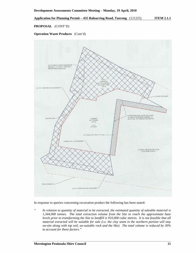
Development Assessments Committee Meeting – Monday, 19 April, 2010 Application for Planning Permit – 435 Balnarring Road, Tuerong (121225) ITEM 2.1.1
Mornington Peninsula Shire Council 11
PROPOSAL (CONT’D) Operation Waste Products (Cont’d)
In response to queries concerning excavation product the following has been stated: “ In relation to quantity of material to be extracted, the estimated quantity of saleable material is
1,344,000 tonnes. The total extraction volume from the Site to reach the approximate base levels prior to transforming the Site to landfill is 910,000 cubic metres. It is not feasible that all material extracted will be suitable for sale (i.e. the clay seam in the northern portion will stay on-site along with top soil, un-suitable rock and the like). The total volume is reduced by 30% to account for these factors.”

Development Assessments Committee Meeting – Monday, 19 April, 2010 Application for Planning Permit – 435 Balnarring Road, Tuerong (121225) ITEM 2.1.1
Mornington Peninsula Shire Council 12
PROPOSAL (CONT’D) Operation Waste Products (Cont’d) “ This would result in an extraction volume of approximately 640,000 cubic metres. Based on an
approximate crushed rock material density of 2.1 tonnes per cubic metres this would equate to a volume of 1,344,000 tonnes. The rate of extraction largely depends on demand associated with the Frankston Bypass construction works. The Work Plan Variation Report states that, when in full operation, the expected output is approximately 60,000 to 100,000 tonnes which is based on a low-demand scenario. The northern Work Plan extension area is anticipated to be largely made up of clay, which is proposed for use onsite in the construction of cells and capping material for the landfill. It is anticipated that the vast majority of the material to be extracted for sale will not require any treatment on site.”
The extractive industry plan submitted for approval is as follows.
Refuse Disposal Supporting documentation in respect to proposed refuse disposal indicates that key features of the proposal involve the following elements: • Restoration of the Rockleigh Quarry site and upgrade of the existing landfill operation to
provide consistent high standard rehabilitation for the whole site. Further extraction of quarry reserves will be undertaken to create separate cells for staged landfill development;

Development Assessments Committee Meeting – Monday, 19 April, 2010 Application for Planning Permit – 435 Balnarring Road, Tuerong (121225) ITEM 2.1.1
Mornington Peninsula Shire Council 13
PROPOSAL (CONT’D)
Refuse Disposal (Cont’d)
• Utilisation of the existing landfill operational infrastructure and site environmental management control systems;
• Construction of a compacted clay liner and associated leachate collection system to confine and control wastes placed within the landfill extension. The liner will tie-in to the existing clay liner previously constructed on the western perimeter of the Devilbend landfill site;
• Creation of a single final landform for the whole site compatible with the surrounding landscape
including the construction of a surface capping system. The cap will connect with the clay side liner around the complete perimeter of the site;
• Water management including the diversion of clean stormwater runoff around the perimeter of
the site and construction of storage ponds for the treatment and disposal of contaminated water associated with the current operation; and
• Construction of a separate lined long term pond for the storage and disposal by evaporation of
leachate generated from the current operations and landfill extension. It is also stated that the engineering works within the Rockleigh Quarry site will require the further extraction of stone and clay reserves to create new landfill cells. The cells will be excavated to match the elevation of the base of the former quarry. Details have been provided as follows: • The construction of a compacted clay liner on the base and side slopes of the new landfill cells.
The compacted clay liner will tie in with the existing clay liner constructed on the western boundary of the Devilbend landfill. A leachate collection system will then be installed over the clay liner to collect leachate accumulating on the base of the landfill and convey it to storages for eventual treatment and disposal. The lining and leachate collection system will ensure the landfill will comply with the objectives and required outcomes of Best Practice Environmental Management (BPEM);
• The operation of the landfill established within the Rockleigh Quarry site will utilise the existing infrastructure associated with the existing Devilbend operation. Site access will be off Balnarring Road and the existing gatehouse, weighbridge and office facilities will be retained;
• The existing system in the Devilbend site of using evaporation ponds to treat stored leachate
collected from the landfill will be retained for the Rockleigh Quarry site. A long term leachate storage and treatment pond will be located in a suitable location within the rehabilitated areas of the site once the existing leachate pond is decommissioned at the end of the filling operations; and
• The installation of a capping layer and vegetated soil cover over the final completed profile of
the combined Devilbend landfill and associated landfill extension. The cap will comprise a combination of compacted clay, subsoil and topsoil layers.

Development Assessments Committee Meeting – Monday, 19 April, 2010 Application for Planning Permit – 435 Balnarring Road, Tuerong (121225) ITEM 2.1.1
Mornington Peninsula Shire Council 14
PROPOSAL (CONT’D)
Refuse Disposal (Cont’d) A staged development is proposed which is described as follows: “ The staged development of the Rockleigh Quarry site will comprise three separate areas. Each
area will be constructed in stage sequence as shown on Figure 2. Due to the proposed tie in to the existing clay liner of the adjacent Devilbend landfill, the staged development of the Rockleigh Quarry site is effectively an extension to the existing Devilbend operation. Accordingly, the three separate areas of the landfill extension become Stages 2, 3 and 4 respectively with the current development of Cells 2 and 3 in the existing landfill being Stage 1. Compacted clay bunds will be constructed to segregate the three new stages. The compacted clay liners of a following stage will connect to the constructed clay bund of the previous stage. The same methodology will be implemented to segregate the initial Stage 2 of the landfill extension from the existing operation within the adjacent Devilbend landfill. The lining of the side slopes in each cell will be undertaken progressively as the landform rises according to the rate of waste filling. The perimeter side slopes of the cells are shown indicatively on the figures as 1V:1.5H. The grade of the side slopes will be assessed during detailed design and is not expected to be steeper than 1V:1.5H. Excavation works will be required in each stage to establish the design elevation for the base liner. The required excavation and subsequent liner construction works for Stage 2 will be undertaken during the remaining operating life of the Devilbend landfill. Subsequently works in the following stage will be undertaken during operation of the preceding stage.”
The following plan shows intended staging of Stages 2, 3 and 4 on the Rockleigh quarry land.

Development Assessments Committee Meeting – Monday, 19 April, 2010 Application for Planning Permit – 435 Balnarring Road, Tuerong (121225) ITEM 2.1.1
Mornington Peninsula Shire Council 15
PROPOSAL (CONT’D)
Refuse Disposal (Cont’d)
In respect to drainage it is stated: “ A stormwater management system is in place at the Rockleigh Quarry site to collect and convey
stormwater towards the natural outfall located at the northwest corner of the site. The system comprises:
• Perimeter overburden cut-off walls constructed around the southern and western
boundaries that divert stormwater away from the former quarry activity located in the southern area of the site;
• A sump within the former quarry that collects stormwater from the lowest elevations of the site which is transferred by pump to the existing water storage located within the Devilbend landfill;
• Natural drainage of surface flow from the untouched northern area of the site to the
northwest corner;”

Development Assessments Committee Meeting – Monday, 19 April, 2010 Application for Planning Permit – 435 Balnarring Road, Tuerong (121225) ITEM 2.1.1
Mornington Peninsula Shire Council 16
PROPOSAL (CONT’D)
Refuse Disposal (Cont’d)
“ The stormwater management system will be upgraded as part of the landfill development of the site to ensure segregation of clean stormwater from the underlying leachate collection infrastructure. This will entail modification to the existing perimeter drainage system and construction of additional surface drains to provide a stormwater diversion system around all landfill stages. The existing sump within the quarry area will also be upgraded to maintain the removal of clean water out of the lowest elevations of the site. The sump will be maintained at a level and position commensurate with the staging of the lifts for the side liner construction. The upgraded stormwater management system will be designed to control rainfall runoff for a one in 10 year storm event in line with the requirements of Best Practice Environmental Management (BPEM). The upgraded stormwater management system will be finalised as part of the detailed design of the cell. Clean stormwater runoff from the progressive stages of the final landfill cap will also be directed to the surface drains around the perimeter of the site. In addition, stormwater which percolates into the subsoil layers constructed as part of the final cap will be collected and conveyed to the perimeter drainage system. Swale drains will also be constructed as part of the final capping works to limit the velocity of stormwater flows and hence prevent erosion of the capped area. Where required, the swale drains will be lined with erosion protection materials to protect the drains from excessive erosion. The swale drains will direct flows to a sediment drop-out dam, which will be designed so that off-site discharges will comply with the relevant environmental and planning requirements. The stormwater pond will be located east of Stage 3. The stormwater pond will be constructed prior to capping of the Devilbend Landfill (existing tipping area and Stage 1). An additional stormwater pond will be required in the north west corner of the Rockleigh Quarry site to collect runoff from Stage 3 once the area is rehabilitated.”
A drainage system for the overall site is shown in the following diagram.

Development Assessments Committee Meeting – Monday, 19 April, 2010 Application for Planning Permit – 435 Balnarring Road, Tuerong (121225) ITEM 2.1.1
Mornington Peninsula Shire Council 17
PROPOSAL (CONT’D)
Refuse Disposal (Cont’d)
In respect to gas management it is stated: “ It is not expected that significant volumes of landfill gas will be generated at the site due to the
low organic nature of the solid inert waste that will be deposited within the landfill. Any gas management system installed at the Rockleigh Quarry site to control landfill gas will need to include the adjacent Devilbend landfill due to the overlap of the completed landforms for both sites. Prior to the completion of filling operations at both sites, a landfill gas assessment would be carried out to determine if the installation of a formal gas extraction system would be required. Due to the low organic nature of the inert wastes and expected low gas generation volumes, it is expected that gas control will comprise a passive system to vent the gas through the final capped surface of the landfill rather than an induced exhaust system that would actively extract the gas using a series of vertical wells placed at frequent intervals. A passive gas management system would comprise a network of perforated HOPE pipes surrounded with aggregate placed beneath the final capping layers of the landfill. The pipes would rise to the apex of the completed landform and be connected to a passive gas vent upright through the landfill cap.”

Development Assessments Committee Meeting – Monday, 19 April, 2010 Application for Planning Permit – 435 Balnarring Road, Tuerong (121225) ITEM 2.1.1
Mornington Peninsula Shire Council 18
PROPOSAL (CONT’D)
Refuse Disposal (Cont’d)
“ The constituents of the landfill gas will be monitored to ensure compliance with appropriate environmental emissions. Gas monitoring bores will be installed at specific locations around the perimeter of the landfill. The bores will be a shallow depth comprising an internal PVC pipe slotted to within 1 to 2 metres of the surface. It is envisaged that any passive gas venting system will also have a dedicated point for gas monitoring. The results of the monitoring of the venting system and the gas bores will be used to assess greenhouse gas emissions data set and also to determine likely disposal options for the gas.”
Waste Type The type of waste proposed to be placed in the land fill is ‘solid inert’ waste this is described by the EPA classification of wastes brochure as: “ Waste that has a negligible activity or effect on the environment. The waste may be either a
municipal or industrial waste.” Industrial waste includes waste arising from all commercial, industrial, building and demolition activities, including: • Manufacturing activities;
• Wholesale/retail trade; • Commercial services including those provided to households (e.g. gardening, skip/bin hire etc); • Accommodation, cafes, restaurants; • Building/demolition waste from building construction, renovations or repairs, and road
construction and maintenance; and • Waste from primary industries including agricultural, forestry and fishing. The EPA Waste Categorisation Brochure states that: “ Re-use and recycle options should be closely examined for this type of waste, as in many cases
solid inert waste such as building materials, can be re-used.” The applicant has stated that no ‘putrescible’ waste is proposed for the land fill. The EPA classifies putrescible waste as: “ Waste able to be decomposed by bacterial action. It may be suitable for composting or
recycled for stockfeed (which includes food wastes from residential, industrial or commercial sources, such as restaurants, food markets, supermarkets, and butchers).”
Operational details for handling wastes have been described in the Application Report as follows: “ The wastes will be deposited and placed at designated active tipping face that will be
established within a defined area in order to minimise potential amenity and environmental issues and to allow for the recovery of non-compliant wastes not identified at the site gatehouse. Waste will be placed by machine operators in even and consolidated layers to create a waste lift thickness of 2 metres at the appropriate density for the type of wastes received.”

Development Assessments Committee Meeting – Monday, 19 April, 2010 Application for Planning Permit – 435 Balnarring Road, Tuerong (121225) ITEM 2.1.1
Mornington Peninsula Shire Council 19
PROPOSAL (CONT’D)
Refuse Disposal (Cont’d) Waste Type (Cont’d) “ Cover will be frequently applied on the deposited waste as necessary to prevent windblown and
odour emissions and at the end of each working day. The cover will comprise of soil and other inert non-combustible materials to provide a trafficable surface which will be graded to prevent the ponding of stormwater. Cover material will be sourced in advance and stockpiled at a location convenient to the active tipping face. An intermediate 300 millimetres layer of cover will be applied to filled areas that will remain inactive for a considerable period of time due to sequential filling requirements. Management systems in place at the Devilbend facility will be utilised to identify loads containing reusable materials. Such loads identified at the gatehouse will be directed to the designated recycling area. The recovery of recyclable materials such as metals will occur at the tipping face and the material transferred to the recycling area.”
Other operational details as advised by the applicant are as follows. Hours of Operation The landfill will be opened for the receipt of wastes six days a week as per the existing Devilbend facility, being 7:00 a.m. to 5:00 p.m. Monday to Friday and 7:00 a.m. to 1:00 p.m. Saturday. Site Access The existing entry and exit routes to and from the Devilbend Landfill off Balnarring Road will be used to gain access to the proposed landfill extension. When accessing the site, waste vehicles will traverse the existing haul road to the gatehouse and weighbridge and then follow the route proposed on the drawings. Vehicle entry to the active disposal areas will be via a two-way all weather roadway appropriately signed posted. Vehicles will exit the site through the wheel wash facility when appropriate to avoid road grime issues on Balnarring Road. Dust Control The dust emission control measures that will be implemented during the operation will comprise the use of a water tanker to wet down all roads and other areas within the landfill that may be a source of dust such as stockpiles and batters. Internal roads will be properly formed and maintained with reduced vehicle speeds enforced to minimise dust generation. Completed areas within the landfill will be re-vegetated as soon as practicable to minimise the risk of windblown dust. Noise and Odour Control There are a limited number of residential or sensitive land use areas within close proximity to the landfill. Subsequently any noise and odour from the operations is not likely to have any significant impact on these areas. However, every effort will be made to ensure odour originating from the operations is not offensive outside the boundaries of the site. The use of daily cover and immediate attention to odorous waste loads will minimise the transmission of odours off-site.

Development Assessments Committee Meeting – Monday, 19 April, 2010 Application for Planning Permit – 435 Balnarring Road, Tuerong (121225) ITEM 2.1.1
Mornington Peninsula Shire Council 20
PROPOSAL (CONT’D)
Refuse Disposal (Cont’d) Bird and Litter Control The inorganic nature of the inert waste to be deposited at the landfill does not give rise to problems associated with birds. The wastes also generally contain little litter. However, any windblown substances would be minimised by the frequent covering of the deposited wastes in accordance with the landfill operation covering procedures. The existing 1.8 metre high security wire mesh fence around the site will also function as an effective barrier for any airborne litter. In respect to site rehabilitation the following details have been provided. Final Cap The final capping layer is primarily designed to ensure the final surface of the landfill will provide a barrier to minimise the infiltration and migration of water into the underlying waste. The capping layer will also limit the uncontrolled release of landfill gas and provide a suitable surface for the re-vegetation of the site that will ultimately allow for the future developmental use. The final capping system that will meet the requirements of BPEM will comprise (in ascending order): • The final 300 millimetres thick layer of cover soil;
• A 500 millimetres thick layer of compacted clay with a hydraulic conductivity of no more than
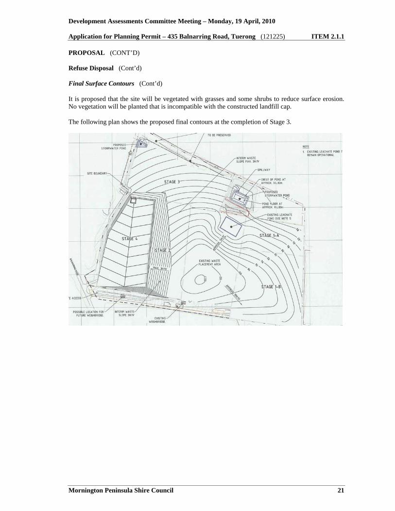
1x10"9m/sec; • A 500 millimetres thick subsoil layer; and • A minimum 100 millimetres thick layer of topsoil. The compacted clay layer of the cap will be keyed into the compacted clay component of the side liner to form a continuous liner around the waste. The capping layers will be installed progressively in stages as the landfill develops to limit the volume of leachate generation. A network of perforated pipes surrounded by aggregate will form part of the final capping system to manage gas. Final Surface Contours The landfill will rise to a maximum level of RL 103 metres AHD which is compatible with the surface profile of the final landform for the Devilbend landfill as proposed in the EIP Rehabilitation Plan. The final profile of the combined sites will create minimal change in visual impact from the surrounding environment and any public access areas adjoining the site. The proposed final surface contours are shown on Figures 9 and 10. The final surface will have sufficient gradient to prevent ponding of stormwater and ensure surface water run-off is directed to the perimeter surface water drainage system. The gradient of the final surface will be 10% over the majority of the site and thus satisfy the BPEM criteria range of 5% to 20%. The site will be progressively rehabilitated and landscaped as filling matches the proposed final landfill contours.
Development Assessments Committee Meeting – Monday, 19 April, 2010 Application for Planning Permit – 435 Balnarring Road, Tuerong (121225) ITEM 2.1.1
Mornington Peninsula Shire Council 21
PROPOSAL (CONT’D)
Refuse Disposal (Cont’d) Final Surface Contours (Cont’d) It is proposed that the site will be vegetated with grasses and some shrubs to reduce surface erosion. No vegetation will be planted that is incompatible with the constructed landfill cap. The following plan shows the proposed final contours at the completion of Stage 3.

Development Assessments Committee Meeting – Monday, 19 April, 2010 Application for Planning Permit – 435 Balnarring Road, Tuerong (121225) ITEM 2.1.1
Mornington Peninsula Shire Council 22
PROPOSAL (CONT’D)
Refuse Disposal (Cont’d) Final Surface Contours (Cont’d) The following plan shows the proposed final contours at the end of the land fill.
PLANNING SCHEME PROVISIONS Zone The application site is located within the Green Wedge Zone – Schedule 3. The purpose of the Green Wedge Zone is as follows: • To implement the State Planning Policy Framework and the Local Planning Policy Framework,
including the Municipal Strategic Statement and local planning policies;
• To recognise, protect and conserve green wedge land for its agricultural, environmental, historic, landscape, recreational and tourism opportunities, and mineral and stone resources;
• To encourage use and development that is consistent with sustainable land management
practices; • To encourage sustainable farming activities and provide opportunity for a variety of productive
agricultural uses;

Development Assessments Committee Meeting – Monday, 19 April, 2010 Application for Planning Permit – 435 Balnarring Road, Tuerong (121225) ITEM 2.1.1
Mornington Peninsula Shire Council 23
PLANNING SCHEME PROVISIONS (CONT’D) Zone (Cont’d) • To conserve and enhance the cultural significance and character of open rural and scenic non-
urban landscapes; and
• To protect and enhance the biodiversity of the area. Decision guidelines as relevant to this application include: • The capability of the land to accommodate the proposed use or development;
• How the use or development relates to rural land use, rural diversification, natural resource
management, natural or cultural heritage management, recreation or tourism; • Whether the site is suitable for the use or development and the compatibility of the proposal
with adjoining land uses; • The protection and retention of land for future sustainable agricultural activities; • The impact of the use or development on the flora and fauna on the site and its surrounds; • The need to protect and enhance the biodiversity of the area, including the retention of
vegetation and faunal habitat and the need to revegetate land including riparian buffers along waterways, gullies, ridgelines, property boundaries and saline discharge and recharge area; and
• The need to minimise any adverse impacts of siting, design, height, bulk, and colours and
materials to be used, on landscape features, major roads and vistas.
Overlays The site as a whole is also affected by the Environmental Significance Overlay. The purpose of that overlay (in addition to implementing State and local planning policy) is: • To identify areas where the development of land may be affected by environmental constraints;
and
• To ensure that development is compatible with identified environmental values. The Environmental Significance Overlay (Clause 42.01-2) imposes the need for permission for the construction of buildings and the carrying out of works, and for the removal, destruction and lopping of any vegetation. Environmental Significance Overlay – Schedule 3 This overlay aims to protect the Central Peninsula, which forms part of the catchment of Balcombe Creek and the waterways that discharge to Dromana Bay. It also contains the Devilbend reservoir and the historic Briars property. It is an area of strategic landscape importance, with an open undulating terrain, and includes the prominent eastern slopes of Mount Martha and the gateway area to the Kangerong basin.

Development Assessments Committee Meeting – Monday, 19 April, 2010 Application for Planning Permit – 435 Balnarring Road, Tuerong (121225) ITEM 2.1.1
Mornington Peninsula Shire Council 24
PLANNING SCHEME PROVISIONS (CONT’D) Overlays (Cont’d) Environmental Significance Overlay – Schedule 3 (Cont’d) Environmental objectives to be achieved are as follows: • To protect and conserve the environmental systems, biodiversity, native vegetation, habitat
areas, land and soil stability, drainage patterns, and stream quality of this area;
• To promote the sustainable development of rural land and integrated land and catchment management, including the retention and enhancement of habitat corridors and wetlands;
• To ensure that subdivision and development density is compatible with maintaining the long
term natural, agricultural and landscape values of this area; and • To promote siting and design of buildings and works that is responsive to the open rural
landscape character and vistas of the area and that maintains the scenic value of roads and recreation routes.
Environmental Significance Overlay – Schedule 17 This overlay has the following statement of purpose: “ The streamlines of the Mornington Peninsula are an integral element of the environmental
systems that support biodiversity, and directly impact on the coastal and marine environments. Streamlines also often provide relatively undisturbed habitat corridors between larger areas of remnant vegetation. The catchment areas of streams and watercourses on the Peninsula are relatively small, increasing sensitivity to inappropriate development.”
Environmental objectives to be achieved are as follows: • To maintain environmental flows and the quality of water within streams and watercourses;
• To maintain the capacity of streams and watercourses to carry natural flows; • To prevent erosion of banks, stream beds and adjoining land and the siltation of watercourses,
drains and other features; • To protect and conserve flora and fauna habitats (including those of fish and invertebrates)
within and along streams and watercourses; • To ensure that development does not occur on land liable to flooding; and • To ensure that subdivision and development is compatible with the environmental values of
streams and watercourses. Environmental Significance Overlay – Schedule 28 This overlay aims to protect native vegetation.

Development Assessments Committee Meeting – Monday, 19 April, 2010 Application for Planning Permit – 435 Balnarring Road, Tuerong (121225) ITEM 2.1.1
Mornington Peninsula Shire Council 25
PLANNING SCHEME PROVISIONS (CONT’D) Overlays (Cont’d) Environmental Significance Overlay – Schedule 28 (Cont’d) Environmental objectives to be achieved are as follows: • To protect and conserve native vegetation and habitat areas, including those of rare, threatened
and endangered flora and fauna species, from clearing, degradation or fragmentation;
• To protect and conserve habitat corridors, including land with a minimum width of 30 metres on both sides of a streamline;
• To arrest and reverse the decline of remanent native vegetation, and to achieve a net increase in
native vegetation within the Shire over time; • To promote the maintenance of ecological processes and biodiversity; • To promote the implementation of regional catchment strategies, regional vegetation plans and
other natural resource management strategies; • To conserve the Shire’s vegetation based landscape assets; • To avoid the loss or detrimental modification of native vegetation through grazing, cropping and
other forms of agriculture; and • To ensure that trees are cleared from no more than 10% of the land effected by this schedule
and understorey from no more than a further 30% of the land effected by this schedule. State and Local Planning Policy Framework The following policies contained in the State Planning Policy Framework (SPPF), Local Planning Policy Framework (LPPF) and particular and general provisions are relevant to the consideration of this application.
State Planning Policy Framework
11.03: Principles of land use and development planning 12.02: Better management of metropolitan growth 14.01: Planning for urban settlement 15.01: Protection of catchments, waterways and ground water 15.04: Air quality 15.05: Noise abatement 15.06: Soil contamination 15.09 Conservation of native fauna and flora 17.03: Industry 17.05: Agriculture 17.09: Extractive industry 18.10: Waste Management 19.03: Design and built form

Development Assessments Committee Meeting – Monday, 19 April, 2010 Application for Planning Permit – 435 Balnarring Road, Tuerong (121225) ITEM 2.1.1
Mornington Peninsula Shire Council 26
PLANNING SCHEME PROVISIONS (CONT’D) State and Local Planning Policy Framework (Cont’d)
Local Planning Policy Framework 21: Municipal Strategic Statement 21.06: Strategic framework and the Peninsula's settlement pattern 21.09: Planning for rural areas 22.06: Development on highways, main roads and tourist routes 22.07: Commercial and industrial uses in rural areas
Other 52.06: Car parking 52.09: Extractive industry and search for stone 52.10: Uses with adverse amenity potential 52.17: Native vegetation 52.29: Land adjacent to a road zone 63: Existing uses 57: Metropolitan green wedge land 65: Decision guidelines
State Planning Policy Framework Relevant aspects of the State Planning Policy Framework are as follows. Clause 12.02: Better Management of Metropolitan Growth This Clause seeks to protect the green wedges of Metropolitan Melbourne from inappropriate development. It acknowledges the need to protect significant resources of stone, sand and other mineral resources for extraction purposes. Clause 15.10: Protection of Catchments, Waterways and Groundwater This Clause sets the objective to assist the protection and, where possible, restoration of catchments, waterways, water bodies, groundwater, and the marine environment. Clause 15.04: Air quality The objective of this Clause is to assist the protection and improvement of air quality. Responsible authorities should ensure that development is not prejudiced and community amenity is not reduced by air emissions by ensuring, wherever possible, that there is suitable separation between potentially amenity reducing and sensitive land uses and developments. Consideration should be given to Recommended Buffer Distances for Industrial Residual Air Emissions (EPA 1990) to determine the extent of separation. Responsible authorities should also have regard to the potential for conflict between land uses or development within a zone due to air emission impacts.

Development Assessments Committee Meeting – Monday, 19 April, 2010 Application for Planning Permit – 435 Balnarring Road, Tuerong (121225) ITEM 2.1.1
Mornington Peninsula Shire Council 27
PLANNING SCHEME PROVISIONS (CONT’D) State and Local Planning Policy Framework (Cont’d) State Planning Policy Framework (Cont’d) Clause 15.05: Noise Abatement The objective of this Clause is to assist the control of noise effects on sensitive land uses. Responsible authorities should ensure that development is not prejudiced and community amenity is not reduced by noise emissions, using a range of building design, urban design and land use separation techniques as appropriate to the land use functions and character of the area. Decision-making by responsible authorities must be consistent with any relevant aspects of the following documents: • State environment protection policy (Control of Noise from Commerce, Industry and Trade) No.
N-1 (in metropolitan Melbourne);
• Interim Guidelines for Control of Noise From Industry in Country Victoria (EPA 1989); and • State environment protection policy (Control of Music Noise from Public Premises). Clause 15.09: Conservation of Native Flora and Fauna It is policy at Clause.15-09 that: “ Planning and responsible authorities must have regard to Victoria’s Native Vegetation
Management – A Framework for Action (Department of Natural Resources and Environment 2002). If a permit is required to remove native vegetation…or an application for subdivision could result in the removal of native vegetation, planning and responsible authorities should follow the three-step approach as defined in the Framework. This is achieved firstly, as a priority, by avoiding the removal of native vegetation; secondly, if the removal of native vegetation cannot be avoided, by minimising the loss of native vegetation through appropriate consideration in planning processes and expert input into project design or management; and thirdly, by identifying appropriate offset actions.”
Clause 17.03: Industry Planning seeks to ensure adequate separation and buffer areas are provided between sensitive uses and offensive or dangerous industries and quarries to ensure that residents are not affected by adverse environmental effects, nuisance or exposure to hazards. Clause 17.05: Agriculture Planning seeks to ensure the State’s agricultural base is protected from the unplanned loss of high quality productive agricultural land due to permanent changes of land use. Clause 17.09: Extractive Industry Planning seeks to identify and protect stone resources accessible to major markets and to provide a consistent planning approval process for extraction in accordance with acceptable environmental standards. It makes reference to the need for buffer areas between extractive industry and sensitive land uses.

Development Assessments Committee Meeting – Monday, 19 April, 2010 Application for Planning Permit – 435 Balnarring Road, Tuerong (121225) ITEM 2.1.1
Mornington Peninsula Shire Council 28
PLANNING SCHEME PROVISIONS (CONT’D) State and Local Planning Policy Framework (Cont’d) State Planning Policy Framework (Cont’d) Clause 18.10: Waste Management Planning seeks to ensure the siting and management of waste disposal facilities are in accordance with State environment protection policy (Siting and Management of Landfills Receiving Municipal Wastes) and relevant regional waste management plans. Local Planning Policy Framework Relevant aspects of the Local Planning Policy Framework are as follows. Clause 21.03-1: Regional Role of the Mornington Peninsula Reference is made to Shire environmental values as follows: “ The Mornington Peninsula contains many environmentally significant areas, including
conservation reserves of international, national and state significance. It also accounts for a substantial section of the catchment and coastline of both Western Port and Port Phillip Bay. It is State Planning Policy that environmentally sensitive areas which play an important recreational role, including Western Port and the Mornington Peninsula, Western Port and Port Phillip Bays and their foreshores should be protected from development which would diminish their environmental, conservation or recreational value.”
Clause 21.09: Planning for Rural Areas This Clause acknowledges that the Peninsula’s rural areas are key elements of the strategic framework plan. In the context of the Peninsula, ‘rural’ refers to land with a diverse range of values. It includes areas that support the natural systems of the Peninsula, including stream catchments, wetlands and ground water recharge areas, bushland habitats and major conservation reserves. It refers to land used for agriculture and primary production. It refers to landscapes, and areas of recreational value and cultural significance. Clause 21.09-1 recognises the environmental significance of the Mornington Peninsula. Clause 21.09-2, notes that extractive industry resources need to be protected for their strategic value, but development of these sites must have regard to the landscape protection values and conservation objectives of this scheme. It is also policy under Clause 21.09-2 that: • Existing extractive industries have reasonable access to available stone resources while being
contained to carefully limited works and sites; and
• The staging of development by extractive industries and subsequent rehabilitation is sensitively effected, with maximum protection for every value and significant aspect of the surrounding area.
Development Assessments Committee Meeting – Monday, 19 April, 2010 Application for Planning Permit – 435 Balnarring Road, Tuerong (121225) ITEM 2.1.1
Mornington Peninsula Shire Council 29
PLANNING SCHEME PROVISIONS (CONT’D) State and Local Planning Policy Framework (Cont’d) State Planning Policy Framework (Cont’d) Clause 22.06: Development on Highways, Main Roads and Tourist routes The policy basis is noted at Clause 22.06 as follows: “ The Municipal Strategic Statement emphasises the importance of the landscape in the regional
recreational role of the Peninsula. The network of highways, main roads and tourist routes serving the Peninsula provide the key point of contact between visitors and the landscape, and the visual sequences along main roads and tourist routes may be regarded as a key recreational asset. Equally, the distinctive character of the Peninsula is in part defined by a number of relatively vulnerable ‘strategic landscapes’. These are the rural and coastal areas between and around the edge of townships. These areas strongly contribute to the sense of place that distinguishes the Peninsula from Metropolitan Melbourne. In this context, the establishment of commercial or industrial developments, including service stations, convenience shops and restaurants/takeaway food shops, and associated advertising signs, along main roads and tourist routes in rural areas, may have a significant negative impact that is disproportionate to the improved level of community service.”
The key relevant objectives of this policy are: • To protect highways, main roads and access routes in rural areas from inappropriate commercial
and visual intrusion, including advertising signs;
• To maintain the rural character of land adjoining main roads and tourist routes and the visual amenity of the outlook from these roads;
• To maintain the integrity of strategic landscapes between and around the Peninsula’s townships
and the recreational value of visual sequences along main roads and tourist routes; • To prevent commercial strip development along highways, main roads and tourist routes and
avoid out-of-centre commercial developments along these roads that undermine the activity centres policy;
• To ensure the safe and efficient movement of traffic along highways, main roads and tourist
routes in the municipality and to avoid a proliferation of access points; • To ensure that facilities to meet the needs of people travelling along highways, main roads and
tourist routes are provided through existing nodes to the maximum extent possible; and • To ensure a high standard of design associated with developments along highways, main roads
and tourist routes.

Development Assessments Committee Meeting – Monday, 19 April, 2010 Application for Planning Permit – 435 Balnarring Road, Tuerong (121225) ITEM 2.1.1
Mornington Peninsula Shire Council 30
PLANNING SCHEME PROVISIONS (CONT’D) State and Local Planning Policy Framework (Cont’d) State Planning Policy Framework (Cont’d) Clause 22.07: Commercial and Industrial Uses in Rural Areas The policy basis is noted at Clause 22.07 as follows: “ A key objective of the Municipal Strategic Statement is to protect and conserve the rural
landscape and character of the Peninsula as a major recreational resource for both the local and wider metropolitan community. This is combined with the objective of supporting the continued agricultural use of land by avoiding the establishment of uses that may exclude or limit legitimate rural activities and farm management practices. In addition, the relatively high density of occupation in some of the Peninsula’s rural areas, based on their high amenity value, should be recognised. The state wide Green Wedge Zone and Farming Zone provides discretion to consider both industrial and restricted commercial uses. However, it is critical to the strategic directions outlined for the Peninsula that rural land is not regarded as cheap industrial land and that the main roads and tourist routes are not seen as an alternative to the existing township commercial areas or as opportunities to achieve high levels of commercial exposure. The cumulative impact of such development would seriously undermine the Peninsula’s strategic role and would be disproportionate to any community benefit. In this context land within the rural zone should not be used for commercial or industrial activities that can be accommodated within the established township and village areas. This includes activities such as takeaway food premises, convenience shops and service stations.”
The key relevant objectives of this policy are: • To maintain permanent non-urban areas of high landscape value for a variety of recreational
activities and experiences and to support sustainable agricultural use of rural land;
• To prevent the establishment of use and development which would reduce the distinctive character of the Peninsula’s rural landscapes;
• To give emphasis to outdoor and unstructured recreation, especially recreational activities that
promote understanding of, cultivate an interest in or are directly associated with rural pursuits the land or coastal environments in their natural state;
• To encourage tourism and recreation uses that minimise the adverse impacts on the amenity of
local residents; and • To ensure that the roads of the Peninsula are protected from inappropriate development and are
maintained as a major landscape and recreational resource. Policies relevant to the application are: • All buildings and works must be designed to contribute to the existing landscape character and
should not seek to dominate, limit or reduce views available from public areas, including road sides;

Development Assessments Committee Meeting – Monday, 19 April, 2010 Application for Planning Permit – 435 Balnarring Road, Tuerong (121225) ITEM 2.1.1
Mornington Peninsula Shire Council 31
PLANNING SCHEME PROVISIONS (CONT’D) State and Local Planning Policy Framework (Cont’d) State Planning Policy Framework (Cont’d) Clause 22.07: Commercial and Industrial Uses in Rural Areas (Cont’d)
• Applications likely to generate significant traffic volumes must demonstrate that additional
traffic can be accommodated by existing road infrastructure without detriment to existing road users or adjoining landowners; and
• The siting and design of all buildings and works must have particular regard to the provisions of
the Environmental Significance, Landscape Significance and Vegetation Protection overlays contained in this scheme.
Particular Provisions Relevant aspects of the applicable Particular Provisions are as follows. Clause 52.06: Car Parking It is a requirement of this clause that: • A new use must not commence or the floor area of an existing use must not be increased until
the required car spaces have been provided on the land; and
• Where the floor area occupied by an existing use is increased, the parking requirement only applies to the floor area of any extension of the use or site area provided the existing number of car spaces is not reduced.
Clause 52.09: Uses with Adverse Amenity Potential The purpose of this Clause is to: • To ensure that use and development of land for extractive industry does not adversely affect the
environment or amenity of the area during or after extraction;
• To ensure that excavated areas can be appropriately rehabilitated; and • To ensure that sand and stone resources, which may be required by the community for future
use, are protected from inappropriate development. Decision guidelines require consideration of the following: • The effect of the proposed extractive industry on any native flora and fauna on and near the
land;
• The impact of the extractive industry operations on sites of cultural and historic significance, including any effects on Aboriginal places;
• The effect of the extractive industry operation on the natural and cultural landscape of the
surrounding land and the locality generally;

Development Assessments Committee Meeting – Monday, 19 April, 2010 Application for Planning Permit – 435 Balnarring Road, Tuerong (121225) ITEM 2.1.1
Mornington Peninsula Shire Council 32
PLANNING SCHEME PROVISIONS (CONT’D) State and Local Planning Policy Framework (Cont’d) Particular Provisions (Cont’d) Clause 52.09: Uses with Adverse Amenity Potential (Cont’d) • The ability of the extractive industry operation to contain any resultant industrial emissions
within the boundaries of the subject land in accordance with the Regulations associated with the Extractive Industries Development Act 1995 and other relevant regulations;
• The effect of vehicular traffic, noise, blasting, dust and vibration on the amenity of the surrounding area;
• The ability to rehabilitate the affected land to a form or for a use which is compatible with the
natural systems or visual appearance of the surrounding area; • The ability to rehabilitate the land so it can be used for a purpose or purposes beneficial to the
community; • The effect of the proposed extractive industry on groundwater and quality and the impact on any
affected water uses; • The impact of the proposed extractive industry on surface drainage and surface water quality;
and • Any proposed provisions, conditions or requirements in a ‘Work Authority’ to be issued under
the Extractive Industries Development Act 1995. Clause 52.10: Uses with Adverse Amenity Potential The purpose of this Clause is to define those types of industries which if not appropriately designed and located may cause offence or unacceptable risk to the neighbourhood. Threshold distances in this clause do not apply to land in a Green Wedge Zone. Clause 52.17: Native Vegetation Removal The purpose of this Clause is to protect and conserve native vegetation to reduce the impact of land and water degradation and provide habitat for plants and animals. It is also to achieve the following objectives: • To avoid the removal of native vegetation;
• If the removal of native vegetation cannot be avoided, to minimise the removal of native
vegetation through appropriate planning and design; and • To appropriately offset the loss of native vegetation. Decision guidelines include the need to have regard to Victoria’s Native Vegetation Management – A Framework for Action (Department of Natural Resources and Environment 2002). It is also necessary to decide in the first instance whether the proposed development can be located and designed to avoid the removal of native vegetation.

Development Assessments Committee Meeting – Monday, 19 April, 2010 Application for Planning Permit – 435 Balnarring Road, Tuerong (121225) ITEM 2.1.1
Mornington Peninsula Shire Council 33
PLANNING SCHEME PROVISIONS (CONT’D) State and Local Planning Policy Framework (Cont’d) Particular Provisions (Cont’d) Clause 52.17: Native Vegetation Removal (Cont’d) No permit is required to remove, destroy or lop native vegetation to the minimum extent necessary to enable the carrying out of Extractive industry in accordance with a work plan approved under the Extractive Industries Development Act 1995 and authorised by a work authority granted under that Act. Clause 65: Decision Guidelines The Decision Guidelines relating to development in Clause 65.01 include the requirement to consider the orderly planning of the area, the effect on the amenity of the area, the extent and character of native vegetation and the likelihood of its destruction, and factors likely to cause or contribute to land degradation, salinity or reduce water quality. NOTIFICATION AND REFERRALS Objections The application was not advertised prior to a VCAT appeal having been lodged. However in accordance with VCAT’s direction, notice was given to all adjoining owners/occupiers and a notice placed in the local newspaper. Council has also been provided with various detailed positions by objectors in respect to the forthcoming appeal. A range of concerns have been expressed which include the following: • In the recent residents’ meeting with Council, EPA, Grosvenor Lodge and the neighbours, the
Grosvenor Lodge Manager said that they considered that noise level testing is not necessary. This is a breach of the requirements as set out in the Permits which Grosvenor Lodge are required to follow. Again indicating Grosvenor Lodge's lack of concern for the neighbours’ amenity loss;
• We have had to report illegal spraying equipment, illegal discharge of contaminated water on
two occasions, the removal of established trees and vegetation on many occasions and have fought for a long time to have Grosvenor Lodge only operate during allowable operating hours;
• Grosvenor Lodge have demonstrated a lack of care and responsibility to work within the guide
lines of the permits they are to work within; • Construction and operation will cause us amenity loss. Noise, dust and visual amenity loss; • Construction work of the facility cannot meet allowable noise levels. Operation of the facility
cannot meet allowable noise levels; • Does not meet Green Wedge guidelines; • Does not meet Council Best Practice Guidelines; and • Too close to residences.

Development Assessments Committee Meeting – Monday, 19 April, 2010 Application for Planning Permit – 435 Balnarring Road, Tuerong (121225) ITEM 2.1.1
Mornington Peninsula Shire Council 34
NOTIFICATION AND REFERRALS (CONT’D) Internal Referrals
Officer Satisfied or Concerns Comments/ConditionsNatural Systems Planner Concerns identified. See comments below. Development Engineer Has not identified concerns provided
the issues contained in Works Approval and Works Authority processes are satisfied.
See comments below.
Traffic Engineer No concerns identified. See comments below. Environmental Health Officer EPA Works Approval required. See comments below.
Council’s Strategic Planner – Natural Systems Council’s Strategic Planner – Natural Systems has reviewed the application and visited the site. Upon reviewing the supporting information including the report prepared by Biosis Research Pty Ltd, concerns have been identified with the extent of vegetation being removed and the impact upon the biodiversity of the site. The Natural Systems Planner does not support the current proposal and agrees with the concerns identified by the Department of Sustainability and Environment. Development Engineer The Development Engineer has identified that subject to approvals being granted by the Department of Primary Industries (DPI) and the Environment Protection Authority (EPA), sufficient attention will be given to the construction of the pits and the operation of the landfill. Traffic Engineer Council’s Traffic Engineer was provided with a copy of the applicant’s traffic report. Upon reviewing the report, no concerns were identified with the proposal with regards to the traffic conditions of the area. Environmental Health Officer Environmental Health Officer has identified that the proposal requires Works Approval under the Environment Protection Act 1970 and that the EPA is the relevant authority to assess the affects of the landfill component of the application on the environmental conditions of the area. External Referrals
Officer Satisfied or Concerns Comments/Conditions Environment Protection Authority Works approval granted. See comments below. Department of Sustainability and Environment
Concerns. See comments below.
Melbourne Water Conditional approval. See comments below. Southern Rural Water – No comments received. Department of Primary Industries Concerns. Draft Work plan to be approved. Aboriginal Affairs Victoria – No comments received. VicRoads Satisfied. See comments below.

Development Assessments Committee Meeting – Monday, 19 April, 2010 Application for Planning Permit – 435 Balnarring Road, Tuerong (121225) ITEM 2.1.1
Mornington Peninsula Shire Council 35
NOTIFICATION AND REFERRALS (CONT’D) External Referrals (Cont’d) Environment Protection Authority EPA has responded to the application as follows: “ As you are aware, EPA has also received a works approval application for an additional landfill
to be sited in the former Rockleigh stone quarry (which is adjacent to the existing Devilbend landfill). EPA notes that the town planning application refers to expansion of the existing landfill operations. Clause 18.10-2 of the VPPs states that the siting and management of waste disposal facilities must be in accordance with relevant regional waste management plans. In this case, Council should satisfy itself that the proposed landfill is provided for and the proposed timing of the landfill accords with the landfill schedule in the Mornington Peninsula Regional Waste Management Plan. In relation to use of the site for further extractive purposes, Council may wish to include in the planning permit any additional amenity protection clauses it deems appropriate, particularly in regard to dust, noise and vibration. The Authority has no objections to the issue of a planning permit, subject to the condition that a Works Approval must be obtained before any activity associated with land filling can occur in the former Rockleigh stone quarry site.”
It is also noted that the EPA has raised questions regarding the Applicant’s acoustic report as follows: “ The report made specific recommendations in relation to the control of noise emissions from the
proposed landfill, among other measures, the construction and use of earthen bund noise barriers. The report did not contain any assurance that Grosvenor Lodge would implement these recommendations. Even if the recommendations were fully implemented, the report indicated that at times during the works, the noise limits calculated in accordance with ‘Interim Guidelines for Control of Noise from Industry in Country Victoria’, ERA Publication N3/89 would be exceeded. In its consideration of the works approval application, EPA will examine what measures are taken to control the volume intensity and quality of noise. Where acceptable noise limits are not met, EPA not only considers the intensity and character of the noise but whether all practical measures, drawing upon best practice noise control measures, have been implemented to mitigate any noise impact. Additional noise control measures, such as acoustic walls constructed on top of the earthen bund walls, better muffling and noise suppression of mobile plant engines are not mentioned within the report.”
Council has been advised that the EPA has granted Works Approval for the landfill component of the application.

Development Assessments Committee Meeting – Monday, 19 April, 2010 Application for Planning Permit – 435 Balnarring Road, Tuerong (121225) ITEM 2.1.1
Mornington Peninsula Shire Council 36
NOTIFICATION AND REFERRALS (CONT’D) External Referrals (Cont’d) Department of Sustainability and Environment In responding to the application, Department of Sustainability and Environment (DSE) has noted that: “ The site has previously been operated as the Rockleigh Quarry. The southern part of the site
has been disturbed and or material removed. The northern part of the site supports areas of Ecological Vegetation Class (EVC) Grassy Woodland (EVC 175) and in the south west corner there is a small area of Swampy Woodland (EVC 937). Both these EVCs have a conservation status of ‘endangered’ in the Gippsland Plain Bioregion within the Port Phillip and Westernport Catchment Management Authority (CMA) area and the patches are considered to be High and Very High Conservation Significance. The Native Vegetation Management Framework, incorporated into the planning scheme (Clauses 15.09 and 52.17) states that the removal of very high conservation significance vegetation is not permitted, unless exceptional circumstances apply, without the approval of the Minister of Environment and Climate Change. One flora species of state conservation significance (rare) was recorded (Veined Spear-grass). It is not identified on the map where this species is located. This species will be removed under the proposal. There have been no assessment undertaken of aquatic habitats and fauna located within. There are two nationally threatened species, listed under the Environment Protection and Biodiversity Conservation Act 1999 (EPBC Act) Growling Grass Frog (litoria raniformis) and Dwarf Galaxias (Galaxiella pusilla) that could occur on the site if there is appropriate habitat. The Biosis report (2008) states that ‘The artificial waterbodies in the north east of the study area provide potential habitat for this species.’”
DSE has indicated that Council must consider the goal of Net Gain as expressed in ‘Victoria’s Native Vegetation Management – A Framework for Action’ (the Framework) when assessing land use development proposals that involve native vegetation removal (Clauses 15.09-2 and 52.17). It has also been stated that the Department is not satisfied with the extent of loss of high and very high conservation significance native vegetation, and that the proposal should aim to explore ways in which to avoid native vegetation removal. At the time of preparing the report, DSE’s concerns are outstanding. Department of Primary Industry DPI have expressed concerns with regards to non-compliance with the VPP Practice Note for Extractive Industries (April 2006). This practice note recommends that a draft work plan endorsed by DPI be submitted with a planning application. This has not occurred as the draft work plan has not been endorsed by DPI. To date there are still outstanding issues concerning the removal of native vegetation and the affect of the proposal on the biodiversity of the area. At this time, consent from DPI has not been provided.

Development Assessments Committee Meeting – Monday, 19 April, 2010 Application for Planning Permit – 435 Balnarring Road, Tuerong (121225) ITEM 2.1.1
Mornington Peninsula Shire Council 37
NOTIFICATION AND REFERRALS (CONT’D) External Referrals (Cont’d) VicRoads VicRoads initially expressed concern that no information had been provided regarding expected traffic generation, traffic volumes or heavy vehicle use. It requested that a Traffic Impact Assessment Report be provided. Since the submission of additional information VicRoads has indicated no objection to the application as follows. The additional information has been assessed by VicRoads and the Right-Turn and Left treatment required into 485 Balnarring Road is type BA (in accordance with Figure 6.4; Austroads Guide to Engineering Practices Part 5: Intersections). Since there seems sufficient shoulder on both approaches to the property, the current access arrangement is deemed to be satisfactory. Therefore VicRoads has no objection to the granting of a planning permit for the development and use of the subject property subject to a number of conditions. Melbourne Water In responding to the application, Melbourne Water has made the following comments: “ Melbourne Water is the Regional Drainage Authority and the relevant Floodplain Management
Authority across the Port Phillip and Westernport Catchment area. Melbourne Water is also responsible for contributing to the protection and improvement of waterway health across greater Melbourne. The Port Phillip and Westernport Regional River Health Strategy (2006) (RRHS) identifies the Balcombe Creek catchment to be of High Significance to Melbourne Water. The Balcombe Creek catchment (or sub-management unit, as it is referred to in the RRHS and Addendum) includes Devilbend Creek, Tuerong Creek and associated tributaries. The 'Flora and terrestrial fauna assessment of the Rockleigh Quarry landfill site, Victoria' report prepared by Biosis Research P/L states on page 3 that ‘Aquatic habitats and fauna located within and/or in proximity to the study area were not included in this assessment’. The Biosis report also identifies on page 19 that ‘further aquatic fauna assessment is recommended to determine the presence/absence of Growling Grass Frog and the potential Impacts of any other aquatic matters of national environmental significance’. Melbourne Water requires further investigation of the environmental values located on site be undertaken as part of an Environmental Impact Assessment. The investigation should also include an evaluation of impacts and proposed mitigation measures for construction and operation of the landfill. Protection of downstream values in the associated waterways should be given consideration. The submitted Environmental Improvement Report does not fully outline measures that would be put in place to minimise environmental disturbance and potential impacts on the drainage lines and the significant downstream values in the event of contamination, spillages, stormwater connection or any discharge from the site.”

Development Assessments Committee Meeting – Monday, 19 April, 2010 Application for Planning Permit – 435 Balnarring Road, Tuerong (121225) ITEM 2.1.1
Mornington Peninsula Shire Council 38
NOTIFICATION AND REFERRALS (CONT’D) External Referrals (Cont’d)
Melbourne Water (Cont’d)
“ It is our understanding that the proposed quarry development works will include an excavation
(50 metres maximum depth) along the northern boundary of the above property. Also, we understand that a 20 metre wide buffer zone from the northern boundary line will apply and will exclude any excavation works. Melbourne Water has two water mains located adjacent to the northern boundary. The two water mains in question are our 900 millimetres and 525 millimetres Bittern-Dromana Mains both of which are major transfer mains located along and adjacent to the northern boundary of the above property. The 900 millimetres main is closest to the above property and is a mild steel pipe and the 525 millimetres main is a reinforced concrete pipe. Melbourne Water requests the following water main protection conditions be included in any planning permit Council issues for the proposed quarry development works, in particular along the northern boundary of the above property. 1. The buffer zone (20 metres wide) along the northern boundary of the property shall be
retained and will exclude any excavation works. 2. The depth of the proposed quarry excavation (50 metres max.) shall not exceed the
distance from the southern boundary of the buffer zone at any stage of the proposed excavations (i.e. the maximum depth of 50 metres cannot be reached inside a distance of 50 metres from the southern boundary of the buffer zone).
3. Blasting is not permitted unless approved by Melbourne Water. The maximum vibration
level shall be 20mm/second as measured at the 900 mm water main. Vibration level equipment shall be set up on the water main and if requested the measurements sent to Melbourne Water.”
CONSIDERATION AND ASSESSMENT Issues to be Addressed in Considering the Application As noted in the summary, the key issues affecting this application are considered to be: • The suitability of the site;
• Consideration of external amenity effects; • Effects on flora and fauna; and • Traffic implications and adequacy of access and parking.

Development Assessments Committee Meeting – Monday, 19 April, 2010 Application for Planning Permit – 435 Balnarring Road, Tuerong (121225) ITEM 2.1.1
Mornington Peninsula Shire Council 39
CONSIDERATION AND ASSESSMENT (CONT’D) Issues to be Addressed in Considering the Application (Cont’d) Suitability of the Site Zone In the past, the site has been of importance for its stone reserves and for the public landfill function that has flowed from past extraction. The expansion of the landfill operations in the land has the potential to extend the landfill operations being undertaken in Rye. The future nearby Freeway construction may provide justification for an expanded extractive industry should the stone from this site be found suitable and required for the project, something that has not been officially confirmed. Whilst the proposal has potential benefits in terms of extending the landfill operations in Rye and the Freeway construction which will commence in the future, the proposal must still satisfy the requirements of the planning scheme, in particular the zone and overlay requirements and the amenity tests referenced throughout the Planning Scheme. The Planning Scheme identifies the purpose of the zone as “To recognise, protect and conserve green wedge land for its agricultural, environmental, historic, landscape, recreational and tourism opportunities, and mineral and stone resources”. However, no particular entitlement exists to establish/expand an extractive industry or a refuse disposal facility in the Green Wedge Zone. Acceptability is determined on the merits of a particular proposal and having regard to relevant policies which are discussed below. Environmental Overlays Environmental Significance Overlay – Schedule 3: Central Peninsula Although the proposal does not include the development of buildings, it does propose to alter the landscape significantly. In the short term, this includes the unsightly appearance of the landfill operation, the extensive excavation works required as part of the extractive industry and the development of acoustic earth bunds located along parts of the southern and western boundaries. Earth bunds are also proposed in close proximity to the eastern property boundary. In the longer term, the rehabilitation plan proposes to significantly alter the profile of the land by up to 6.6 metres in some areas. The Central Peninsula is an area of strategic landscape importance, with an open undulating terrain and rehabilitation of a quarry site should in principle reflect an outcome that attempts to respond positively to the statement of environmental significance. The approach taken with the application has tended to be one where the mandatory EPA minimum boundary setback is applied with some adjustment in response to the environmentally sensitive northern part of the site – the emphasis being on maximising the potential extractive industry and future landfill air space. However, the environmental objectives to be achieved as noted earlier in this report include: • To protect and conserve the environmental systems, biodiversity, native vegetation, habitat
areas, land and soil stability, drainage patterns, and stream quality of this area;

Development Assessments Committee Meeting – Monday, 19 April, 2010 Application for Planning Permit – 435 Balnarring Road, Tuerong (121225) ITEM 2.1.1
Mornington Peninsula Shire Council 40
CONSIDERATION AND ASSESSMENT (CONT’D) Issues to be Addressed in Considering the Application (Cont’d) Suitability of the Site (Cont’d)
Environmental Overlays (Cont’d)
Environmental Significance Overlay – Schedule 3: Central Peninsula (Cont’d)
• To promote the sustainable development of rural land and integrated land and catchment
management, including the retention and enhancement of habitat corridors and wetlands;
• To ensure that subdivision and development density is compatible with maintaining the long term natural, agricultural and landscape values of this area; and
• To promote siting and design of buildings and works that is responsive to the open rural
landscape character and vistas of the area and that maintains the scenic value of roads and recreation routes.
This gives an entitlement to also pursue legitimate landscape and environmental outcomes. As noted above, the requirement for extraction in the most sensitive part of the site is not to secure a valuable stone resource and in these circumstances, and noting the comments of Council’s Strategic Planner – Natural Systems earlier in this report, there would appear to be a valid basis to scale back future extraction to better meet the above objectives. Additionally, the outcomes achieved during operations on the land and after the site has been extracted and filled needs to be ones that have appropriate regard to the visual amenity of the area in addition to the long term conservation and protection of the environmental systems of the site and the surrounding locality. The proposal in its present form does not seek to achieve this. But rather, it attempts to provide inappropriate solutions to the further expansion of the uses on the land unit with particular reference to the finished height of the rehabilitated land parcel. Environmental Significance Overlay – Schedule 17: Streamlines The streamline overlay runs directly through the existing quarry operations and is highly modified. The Consultant’s Application Report has indicated the presence of intermittent creeks, with two gullies connecting in the north-west corner of the proposed landfill site. However there is no indication of running creeks, despite this issue being raised during a meeting with objectors. A site visit carried out during the course of the planning application also identified the running creek. Albeit, it is acknowledged that the flow of water was limited. As the Regional Drainage Authority and the relevant Floodplain Management, Melbourne Water has provided consent subject to a number of conditions. At the time of preparing this report, comments have not been received from Southern Rural Water.

Development Assessments Committee Meeting – Monday, 19 April, 2010 Application for Planning Permit – 435 Balnarring Road, Tuerong (121225) ITEM 2.1.1
Mornington Peninsula Shire Council 41
CONSIDERATION AND ASSESSMENT (CONT’D) Issues to be Addressed in Considering the Application (Cont’d) Suitability of the Site (Cont’d) Environmental Overlays (Cont’d) Environmental Significance Overlay – Schedule 28 – Mornington Peninsula Bushland The ESO28 overlay only affects small portions of land in the areas where vegetation removal is required and where earth bunding has been suggested by the Acoustic Consultant (i.e. along the southern boundary). Vegetation removal issues are discussed below as part of the consideration of State policy requirements and Clause 52.17. Local Policy The main applicable policy is the Local Planning Policy, Clause 22.07 Commercial and industrial uses in rural areas. The policy identifies that whilst planning applications can be made for industrial uses in rural areas, there are key objectives which should be met. These objectives relate to the retention of rural character, protection from amenity impacts and promoting linkages between commercial or industrial uses and the rural activities on the land. In this case, the existing condition and history of the site and its uses must be taken into account. Generally the proposal is consistent with the decision guidelines of the rural zone as: “ The land is capable of containing the use. Whilst not a rural use the proposal is consistent
with the ongoing uses of the land.” However as will be discussed further in the report, the proposal has not demonstrated that it will not “ .. impinge upon an existing rural activity.” In respect to Council’s vision for a sustainable Peninsula, Goal 4.5 of the Community plan seeks: “ To implement a waste management strategy that ensures maximum value is extracted from
products before they are finally dispensed with.” In addition a key direction within Melbourne 2030 with ‘A Greener City’ seeks to reduce resource use and waste generation. This is an area where the proposal appears to adopt a relatively minimalist approach. The previous relatively strong support for the ‘Rockleigh’ land fill was a response to a proposal where recycling was a fundamental part and which in turn required a smaller landfill footprint.

Development Assessments Committee Meeting – Monday, 19 April, 2010 Application for Planning Permit – 435 Balnarring Road, Tuerong (121225) ITEM 2.1.1
Mornington Peninsula Shire Council 42
CONSIDERATION AND ASSESSMENT (CONT’D) Issues to be Addressed in Considering the Application (Cont’d) Consideration of External Amenity Effects Central to the assessment of this proposal is the potential for off-site amenity impacts of both the expanded extractive industry and the landfill. This is also the key element in the objections against the proposal. As noted earlier in this report, objectors to this application have cited ongoing amenity impacts from the existing landfill operation. The objectors fear a further loss of rural amenity through the impacts of noise, visual intrusion, dust, pollution and litter. Noise Noise emissions generated by landfill operations outside of the Melbourne Metropolitan area are governed by EPA Publication N3/89 – Interim Guidelines For Control Of Noise From Industry In Country Victoria. Compliance with this publication is not mandatory. Marshall Day Acoustics were commissioned by Grosvenor Lodge to determine the noise impact of the proposed landfill activities and, if required, make recommendations for noise control. Marshall Day Acoustics submitted a report titled Devilbend Landfill and Rockleigh Quarry Noise Impact Assessment to Grosvenor Lodge on 3 December, 2008 with the following conclusions: Existing noise emissions meet the SEPP N-1 noise limits at four of the five neighbouring residential properties. The existing noise emissions marginally exceed the SEPP N-1 noise limits by 1dB at one residence – 413/415 Balnarring Road (west dwelling). Compliance with the noise limits at this dwelling can be achieved by fitting broadband reverse beepers to the bulldozer and compactor. At the proposed landfill extension, the SEPP N-1 noise limits will not be exceeded until the fill reaches a height level where a direct line-of-sight from the fill activities to the nearest residential dwellings occurs. At this stage, the SEPP N-1 noise limits will be marginally exceeded by 1-2dB at a number of dwellings. It was noted that the report provided a prediction of noise from proposed operations to all surrounding receivers. It was also noted that the CONCAWE method was used for calculations. However, there is no description of the meteorological conditions assumed for the calculations. Noise levels can be significantly increased at receivers that are 180 metres to 300 metres away under particular wind directions or other atmospheric conditions. It is expected the acoustic figures provided will vary significantly depending on weather patterns. An initial response is that: 1. If any excavation type works are to be associated with the new site, these will need to be
included in calculations and assessed.

Development Assessments Committee Meeting – Monday, 19 April, 2010 Application for Planning Permit – 435 Balnarring Road, Tuerong (121225) ITEM 2.1.1
Mornington Peninsula Shire Council 43
CONSIDERATION AND ASSESSMENT (CONT’D) Issues to be Addressed in Considering the Application (Cont’d) Consideration of External Amenity Effects (Cont’d)
Noise (Cont’d)
2. While the extent of background noise monitoring is minimal, it is anticipated that additional
background noise monitoring will be unlikely to result in a change in noise limits. For this to occur, the background noise levels would need to be below 38 dBA l_90. It would be desirable but not essential to conducted additional background noise measurements with the existing facility not operating (for an extended period – i.e. at least 24 hours).
3. The meteorological conditions used for calculations should be made clear. In addition, if the results presented are for neutral meteorological conditions, some assessment or consideration should be given to enhanced noise emissions due to ‘worst case’ wind directions.
Since the initial submission of an acoustics assessment, further information was provided as follows: “ Results of the noise modelling indicate that, without noise control, noise levels will exceed the
operational noise limit at times. It is recommended that a combination of noise management techniques be employed, including:
• Noise barriers in the form of earthen bunds or acoustic fences should be constructed at
certain locations around the site. A drawing showing a suitable height and location is provided in Appendix C (Appendix 2 of this report). These barriers will reduce noise from many activities on the site;
• A cutting should be constructed leading from the entrance north into Stage 2 at Rockleigh and east toward Devilbend. The drawing in Appendix C (Appendix 2 of this report) shows a suitable cutting. This cutting will reduce noise from truck movements by locating that part of the truck route behind a cutting and by reducing the height of the truck movements so that the barriers will more effectively screen the noise;
• Extraction of material from the hump between Stages 2 and 4 at Rockleigh should be
done at a high rate in order to minimize the amount of time there will be a bulldozer on the hump. Extraction of the hump should be timed to coincide with periods when the noise from other activities is not close to the noise limit;
• A roadway should be constructed along the western boundary at the bottom of the Stage 4
pit and retained for access to Stages 2 and 4 and Stage 3 for excavation and land filling;
• If material excavated from Stage 3 has to be stockpiled, the stockpile should be located at low ground level. The south-west corner of Stage 4 (once it is fully excavated) may be a suitable location;
• In addition to the above, equipment location and truck routes should be located at low
ground levels wherever possible. The lower the activity, the more effectively the noise barriers and pit edges will screen the noise;”
Development Assessments Committee Meeting – Monday, 19 April, 2010 Application for Planning Permit – 435 Balnarring Road, Tuerong (121225) ITEM 2.1.1
Mornington Peninsula Shire Council 44
CONSIDERATION AND ASSESSMENT (CONT’D) Issues to be Addressed in Considering the Application (Cont’d) Consideration of External Amenity Effects (Cont’d)
Noise (Cont’d) “ • Land filling in Cells 3A and 3B and in Stages 2 and 4 should be done in small cells rather
than large cells, or filling the entire pit as one cell. Each cell should be filled completely before landfill commences in the next cell, except on Saturdays (see below). The highest noise levels occur while activity is at high ground heights. By filling small cells, the times that are noisiest will be broken up into several short periods of a few months rather than extended periods of higher noise levels;
• When noise from landfill in the current cell is getting close to the noise limit, the next cell should be lined. On Saturdays, landfill would be restricted to the new cell;
• Excavation should be limited to weekdays only; and
• Capping of filled cells should be limited to weekdays only and occur during; and winter
months when nearby residences are likely to have their windows closed.” It is also apparent that the possible solution of lowering the fill height was identified in respect to future noise problems but dismissed on the basis that the Acoustics Consultants were advised that this was not practicable. It is also stated in the additional information provided by the Applicant’s Acoustics Consultants that to comply with the 46dBA daytime noise limit, the existing bund on the west boundary adjacent to Stage 4 at Rockleigh would need to be increased in height by 8 metres, or an 8 metre high noise wall constructed on top of the existing bund, to comply at 495 Balnarring Road (but would also achieve compliance at 485 Balnarring Road). We have been advised that an acoustic wall of this height would be unacceptable visually and would be prohibitively expensive to build, particularly as the uncompacted soil in the existing bund would necessitate extremely deep footings. We have also been advised that a bund of this height would not be economically feasible, would require too much space, and may also have unacceptable visual impacts. There is a serious concern that an unacceptable noise outcome will occur and alternative ways need to be considered including the lowering of the height of fill and increasing the distance of extractive industry and landfill operations from property boundaries. In support of the application, the acoustic report identified that noise monitoring occurred on the adjacent land to the west and that on average, the noise emissions from the site exceeded the 46dBA standard. Whilst it is important to note that the noise emissions and the average background noise levels were in excess of the EPA standards, the noise source was located a significant distance from the dwellings to the west and was 20 metres below the final capped height. If the noise source was located within the approximate area of the proposed works and were taken closer to ground level, it could be expected that the noise levels would be considerably greater. In addition, the noise sources identified in the acoustic report do not include machinery mentioned in the Work Plan Variation report submitted to Council and DPI. These noise sources include a mobile crushing unit and a hydraulic rock breaker which have the potential to contribute significantly to noise emitted from the site.

Development Assessments Committee Meeting – Monday, 19 April, 2010 Application for Planning Permit – 435 Balnarring Road, Tuerong (121225) ITEM 2.1.1
Mornington Peninsula Shire Council 45
CONSIDERATION AND ASSESSMENT (CONT’D) Issues to be Addressed in Considering the Application (Cont’d) Consideration of External Amenity Effects (Cont’d)
Noise (Cont’d) Whilst the acoustic report has identified that it is not practical to consider increased buffer distances from the adjoining properties and to limit the footprint of the operations, it is considered that this is what is required to occur in order to ensure that the proposal satisfies the EPA noise requirements during periods of varying weather conditions and during all stages of the proposal. Not only during times when the operations on the land are below ground level. In order to achieve compliance with the standard EPA requirements and Clause 22.07 Commercial and industrial uses in rural areas, it is imperative that alternative solutions be adopted that not only protects the acoustic amenity of the residents in the area but also achieves an outcome that is visually compatible with landscape quality of the locality. This includes among other things, a reduction in the footprint of the extraction and landfill area, the siting of earth bunds away from property boundaries and the maximum retention of vegetation on the land (within the footprint of the proposed extraction pit and the ancillary works associated with the earth bunds etc). Consideration needs also to be given to reducing the height of the finished landfill levels which will reduce the potential for off site impacts associated with machinery operating on the land. Dust and Litter Mention is made in the objections received from concerned residents with regards to the litter and dust emissions. An inspection of the immediate locality reveals that the various allotments are used predominately for animal keeping and residential use. Given the nature of the use and the potential associated with the spread of litter and dust, the further expansion of the landfill and quarry activities on the land has the potential to significantly affect the amenity and operations of the adjoining properties. Whilst it is possible to include conditions of approval which could address these issues (eg, requiring all work on-site to cease during days of specified weather conditions), these methods could provide over restrictive to a point where compliance would be difficult to achieve from a performance point of view as well as from an economic point of view. Visual Amenity As mentioned previously, the proposal does not have sufficient regard for the natural landscape quality of the area due to the excessive height of the landfill. In addition to the proposed vegetation removal required along the site’s common boundaries for the earth bunds have the potential to open site up, not only from the adjoining properties but also to the users of Balnarring Road. Whilst at present views to the site from public vantage points are limited, this has the potential to change if bunding towards the front of the site is required to be provided to address acoustic issues. Additionally, the visual intrusion associated with the use of the land as a landfill from the adjoining properties (particularly the land to the north) for an unspecified time is considered to be unacceptable and not in keeping with the objectives of ESO 3.

Development Assessments Committee Meeting – Monday, 19 April, 2010 Application for Planning Permit – 435 Balnarring Road, Tuerong (121225) ITEM 2.1.1
Mornington Peninsula Shire Council 46
CONSIDERATION AND ASSESSMENT (CONT’D) Issues to be Addressed in Considering the Application (Cont’d) Effects on Flora and Fauna Biosis Research Pty Ltd was commissioned by Grosvenor Lodge to undertake a flora and terrestrial fauna assessment of the Rockleigh Quarry. Biosis Research undertook a flora and terrestrial assessment in February 2008, and a further flora assessment in April 2008. Two ecological vegetation classes (EVCs) have been identified at the Rockleigh Quarry – Grassy Woodland and a small area of Swampy Woodland. Both EVCs are endangered and patches within the Rockleigh Quarry area have been identified to have high and very high conservation significance with respect to Net Gain policy. Three fauna habitat types occur within the proposed landfill site. There are seven mapped vegetation quality zones within the area reviewed by the Consultants having an area of 2.3 hectares. These are shown on the following plan.
One flora species of state conservation significance is located within the proposed landfill site and will be completely removed by extractive industry activities. The proposal will result in the removal of significant amounts of natural vegetation which will have direct and indirect impacts on flora and fauna at and around the site. The proposed design has been modified to retain vegetation along the northern boundary of the site and to minimise impacts on vegetation.

Development Assessments Committee Meeting – Monday, 19 April, 2010 Application for Planning Permit – 435 Balnarring Road, Tuerong (121225) ITEM 2.1.1
Mornington Peninsula Shire Council 47
CONSIDERATION AND ASSESSMENT (CONT’D) Issues to be Addressed in Considering the Application (Cont’d) Effects on Flora and Fauna (Cont’d) The main sources of direct impacts to flora and fauna at the Rockleigh Quarry will occur as a result of vegetation and habitat removal, including: • Removal of 1.6 hectares of endangered Grassy Woodland vegetation;
• Removal of 12 small, one medium and one large scattered trees and removal of 16 of the
25 large old trees within patches; • Removal of one flora species of state significance – Austral Spear-grass; • Removal or reduction in population size of some regionally significant flora species; and • Reduction in viability of retained vegetation as habitat. The Biosis Research report initially was sufficient in fully assessing the impact of the proposed landfill on the Growling Grass Frog in and around the artificial wetland habitat. The consultants observed that the study area was investigated to determine the values of the area for aquatic fauna with a particular focus on Dwarf Galaxias and Growling Grass Frog. These values were determined on the basis of the types and qualities of habitat(s) present on the site and on the results of techniques specifically designed to detect the relevant species. In order for potential downstream impacts to be evaluated, and likely spatial variability in aquatic fauna communities, the study area included investigation of waterways on land adjacent, upstream and downstream of the site of primary investigation. The assessment for aquatic fauna incorporated aquatic habitat assessment at ten sites. Surveys were conducted at six of these sites, where habitat was considered appropriate for threatened aquatic species. Standard fish sampling techniques (i.e. bait traps, nets) were utilised. In respect to this matter it was concluded that fauna surveys designed to detect the presence of Growling Grass Frog and Dwarf Galaxias have not found either species within the Rockleigh quarry/landfill property or on immediately adjacent properties. Dwarf Galaxias was found some distance downstream in Devilbend Creek. It is also noted that the Consultants make the following observation concerning the area at the eastern end of the site (containing vegetation quality zones 1 and 2) where the stormwater pond and leachate pond are to be located. There is a high risk of damage to this vegetation during development of the bund wall as the existing soil stockpiles immediately abut the vegetation. However these areas have been nominated as ‘retained’ as the landfill design has been specifically amended to avoid impact to this vegetation. Special care will be required to protect these areas during construction. The Biosis Research Report has also provided a number of recommendations to minimise the potential ecological impact of the proposed landfill. These will be matters addressed in ‘without prejudice conditions’ to be circulated prior to the hearing.

Development Assessments Committee Meeting – Monday, 19 April, 2010 Application for Planning Permit – 435 Balnarring Road, Tuerong (121225) ITEM 2.1.1
Mornington Peninsula Shire Council 48
CONSIDERATION AND ASSESSMENT (CONT’D) Issues to be Addressed in Considering the Application (Cont’d) Effects on Flora and Fauna (Cont’d) Having noted the Biosis Report, it is appropriate to observe that it correctly notes that the proponent for a development must demonstrate that the option to avoid and minimise vegetation clearance has been fully explored before considering offsets. Responding to this, the Report includes the comment: “ Vegetation losses will not be able to be avoided under the proposed development of the majority
of the site as a landfill area.” The vegetation assessment report produced on behalf of the Applicants should not be seen as endorsing the proposed vegetation removal or implying that it forms the basis for deciding that the principle of avoiding native vegetation removal as the first step has been followed. That is the decision of the Applicant, and as is apparent from its submission, the Applicant considers that the maximum extraction and landfill must occur, which means that only a relatively small amount of native vegetation should be retained. It is on this basis that it submits that the requirements of the Victoria’s Native Vegetation Management – A Framework for Action, have been met. It is acknowledged that some may place a higher value on the extractive industry resource but as noted earlier in this Report some of the clearing is in reality to create more tipping space rather than securing a high quality stone resource. The Planning Scheme directs that: “ Planning and responsible authorities must have regard to Victoria’s Native Vegetation
Management – A Framework for Action (Department of Natural Resources and Environment 2002). If a permit is required to remove native vegetation, or an amendment to this scheme or an application for subdivision could result in the removal of native vegetation, planning and responsible authorities should follow the three-step approach as defined in the Framework. This is achieved firstly, as a priority, by avoiding the removal of native vegetation; secondly, if the removal of native vegetation cannot be avoided, by minimising the loss of native vegetation through appropriate consideration in planning processes and expert input into project design or management; and thirdly, by identifying appropriate offset actions.”
It is clear that there is no automatic entitlement to extractive industry and landfill use on Green Wedge land and in these circumstances it is also clear that steps of Victoria’s Native Vegetation Management – A Framework for Action to avoid and minimise the removal of vegetation can be achieved by further reducing the excavation footprint. This would more readily enable key policy requirements to be met as follows: • To protect and conserve native vegetation to reduce the impact of land and water degradation
and provide habitat for plants and animals;
• To avoid the removal of native vegetation (Clause 52.17 – Native vegetation); and • To protect and conserve the environmental systems, bio diversity, native vegetation, habitat
areas, land and soil stability, drainage patterns, and stream quality of this area (ESO3).

Development Assessments Committee Meeting – Monday, 19 April, 2010 Application for Planning Permit – 435 Balnarring Road, Tuerong (121225) ITEM 2.1.1
Mornington Peninsula Shire Council 49
CONSIDERATION AND ASSESSMENT (CONT’D) Issues to be Addressed in Considering the Application (Cont’d) Effects on Flora and Fauna (Cont’d) It is noted that at present, the Department of Sustainability and Environment does not support the proposal on environmental grounds with particular respect to the affect of the development and use on the native vegetation and the habitat of the site. This view is also supported by Council’s Natural Systems Planner. Traffic Implications and Adequacy of Access Traffic The applicant’s Traffic Consultants have undertaken an assessment on the proposal described in their report. It states that this data shows the existing landfill typically generates in the order of 65-80 heavy vehicle movements per weekday, with up to 12 movements during any one hour. The Wednesday during the survey period was the busiest day, with 84 movements recorded with a maximum of 12 movements recorded between 8:00 a.m. and 9:00 a.m. Saturday volumes were well below those on weekdays, with only 12 truck movements recorded on the Saturday morning. Advice from Grosvenor Lodge Pty Ltd is that around 70% of truck movements are to/from the north. The landfill also generates around six traffic movements per day associated with staff, however these do not coincide with truck movements as staff typically arrive prior to the landfill opening and depart after then landfill has closed. Extractive Industry Traffic Generation Advice from AECOM and Grosvenor Lodge Pty Ltd is that there is in the order of 1,344,000 tonnes of saleable material with the proposed expanded quarry area plus additional material that would be used on-site. Subject to demand for material generated by the Frankston Bypass construction works, it is expected that the saleable material would be extracted over a 2-10 year period, with the shorter period based on a high demand scenario associated with the Frankston Bypass and the longer period a lower demand scenario based on underlying demand. The extractive industry will operate between 7:00 a.m. and 6:30 p.m. Monday to Friday and 7:00 a.m. to 1:00 p.m. Saturdays, excluding public holidays, which equates to 275 full operating days of 11.5 hours per year. We are advised that material is likely to be carted in ‘truck and dog’ heavy vehicles that have a capacity of 30 tonnes each. Based on the above and a steady demand for material, 82 trucks per weekday would be required to cart saleable material from the site, with 16 trucks per weekday required for the low volume scenario. Truck movements on Saturday would be half due to the shorter operating time.

Development Assessments Committee Meeting – Monday, 19 April, 2010 Application for Planning Permit – 435 Balnarring Road, Tuerong (121225) ITEM 2.1.1
Mornington Peninsula Shire Council 50
CONSIDERATION AND ASSESSMENT (CONT’D) Issues to be Addressed in Considering the Application (Cont’d) Traffic Implications and Adequacy of Access (Cont’d) Extractive Industry Traffic Generation (Cont’d) Advice from Grosvenor Lodge Pty Ltd is that 85% of truck movements will likely be to and from the north. The extractive industry operation will also generate staff movements. However as with the landfill, such movements will generally take place prior to the quarry opening at 7:00 a.m. and after the quarry has closed at 6:30 p.m. and will not coincide with truck movements or road network peak hours. To determine traffic volumes on Balnarring Road, an automatic tube count was undertaken from Friday, 9 August, 2009 through to Tuesday, 11 August, 2009 and show that Balnarring Road carries in the order of 2,800 vehicle movements per day and up to 275 movements during the afternoon peak hour. The landfill operation ceases prior to the afternoon peak hour and as such the critical period for the traffic impacts of the landfill and expanded quarry operations will be the weekday morning peak hour. A maximum of 12 truck movements were generated by the landfill during the morning peak hour on the Wednesday. Conservatively assuming that up to 10% of the extractive industry vehicle movements would occur during the morning peak hour, the quarry operation would generate an additional two truck movements for the low output scenario and 8 truck movements for the high output scenario. The expected turning volumes for both the high and low quarry output are below the warrants for a right turn or left turn treatment for vehicles entering the landfill and quarry sites. As such it is considered that no additional access treatment is required and that the current access arrangements will satisfactorily cater for the landfill and expanded extractive industry operations. The conclusions provided by Cardno Grogan Richards appear reasonable based on the actual counts of through traffic and turning movements undertaken during August 2009. However, it is unclear if any seasonal variations to traffic flows or waste volumes have been considered. For example, an increase in tourists holidaying on the Mornington Peninsula during the summer months may result in an increase on through movements on Balnarring Road during morning peak hour and non-peak hours. Nor is it clear as to the extent of truck movements relative to what are certain demands for stone (if any) from the Freeway construction. As noted earlier in this report, VicRoads has not objected to the application subject to conditions being included on an approval. This view is also supported by Council’s Infrastructure Team. CONCLUSION In reaching a conclusion on this matter it has been appropriate to observe the approach taken with the existing land fill. A relatively recent inspection showed that Cell 1 is complete, but it appears to be significantly over height. The storage of spoil on this area has also prevented it from being rehabilitated. Minimal landscaping if any has been undertaken as part of the rehabilitation process. Cell 2 is now also complete. Cell 3 has been split into cell 3A and cell 3B. Cell 3A is currently being filled.

Development Assessments Committee Meeting – Monday, 19 April, 2010 Application for Planning Permit – 435 Balnarring Road, Tuerong (121225) ITEM 2.1.1
Mornington Peninsula Shire Council 51
CONCLUSION (CONT’D) The proposed northern most stage which lies outside the current work approval boundary has had work undertaken within it, including the clearing of native vegetation, the partial construction of a bund wall along the western boundary and the excavation of some clay material. Controls to prevent the infestation of weeds do not appear to have been implemented. The landfill is also clearly visible from the nearby dwelling and multiple properties. It is readily apparent from this viewing point as to where the original cell 1 landfill cap level was and where it now is. The extension appears to be significant. As stated in the preliminary comments to this assessment, the current proposal in effect pushes the boundaries to achieve maximums in extraction and future land fill. It relies on what are in reality minimal landscape buffers and has the potential to be visible well beyond the adjoining properties. It is considered that where there may not be a great deal of confidence that a robust and timely approach to rehabilitation will occur, such a minimalist approach (which also results in the destruction of significant flora and fauna habitat) is difficult to support. This comes at the expense of the natural environment as it requires the extraction of clay and sand from a highly sensitive part of the site to provide capping material for the land fill. Excavation and landfill into the most sensitive areas of the site therefore seems unnecessary and undesirable. If the extraction footprint were to be pulled back from this area it would appear that the environmental position would be improved and that it may be easier to meet acoustic requirements with appropriate visual outcomes. It does not appear that the applicant would wish to scale back the proposal and accordingly at this stage it is considered that Council should not support the proposal. RECOMMENDATION
That the Victorian Civil and Administrative Tribunal be advised at the hearing that Council does not support Planning Application P09/0018 for the proposed extractive industry native vegetation removal refuse disposal and associated works at 435 Balnarring Road, Tuerong on the following grounds: 1. The proposal has not demonstrated compliance with the environmental objectives of
Environmental Significance Overlay – Schedule 3 with particular regard to the protection of the rural landscape character of the area and the protection and conservation of native fauna and flora.
2. The proposal has not demonstrated compliance with the environmental objectives of
Environmental Significance Overlay – Schedule 28 with regards to the maintenance of the ecological and biodiversity processes of the site and the conservation of the Shire’s vegetation based landscape assets.
3. The application is deficient is demonstrating that an unreasonable loss of amenity
will not result to nearby properties resulting from noise emissions from the site.

Development Assessments Committee Meeting – Monday, 19 April, 2010 Application for Planning Permit – 435 Balnarring Road, Tuerong (121225) ITEM 2.1.1
Mornington Peninsula Shire Council 52
RECOMMENDATION (CONT’D) 4. The application has not demonstrated that the rural use on the adjoining properties
will not be compromised as a result of noise emanating from the land.