REPORT ON THE CROSS-BORDER IMPACT FROM ILLEGAL … · 2018-12-02 · EUROPEAN UNION REPORT ON THE...
88
EUROPEAN UNION REPORT ON THE CROSS-BORDER IMPACT FROM ILLEGAL DUMPS ON THE TERRITORY OF THE MUNICIPALITY OF VIDIN Project CB007.1.31.304 “Prevention and mitigation of consequences of man-made cross-border disasters in the region Vidin-Zajecar” The project is co-funded by the EU through the Interreg-IPA CBC Bulgaria–Serbia Programme. 2018
Transcript of REPORT ON THE CROSS-BORDER IMPACT FROM ILLEGAL … · 2018-12-02 · EUROPEAN UNION REPORT ON THE...

EUROPEAN UNION
REPORT ON THE CROSS-BORDER IMPACT FROM ILLEGAL
DUMPS ON THE TERRITORY OF THE MUNICIPALITY OF VIDIN
Project CB007.1.31.304 “Prevention and mitigation of consequences of
man-made cross-border disasters in the region Vidin-Zajecar”
The project is co-funded by the EU through the Interreg-IPA CBC
Bulgaria–Serbia Programme.
2018

П Project CB007.1.31.304 "Prevention and mitigation of consequences of man-made cross-border disasters in the
region Vidin-Zajecar” concerning Interreg-IPA CBC Bulgaria–Serbia Programme 2014 — 2020
The project is co-funded by EU through the Interreg-IPA CBC Bulgaria–Serbia Programme 2014 — 2020 2
Contents
List of figures ................................................................................................................... 3
1. Introduction ............................................................................................................... 6
1.1. The aim and the scope of the study .................................................................... 6
1.2. The Cross-Border Context .................................................................................. 7
1.3. Geographical and demographic characteristics of Vidin municipality ................. 9
1.4. Geographical and demographic characteristics of Zajecar municipality ........... 13
2. Past experience and problems with illegal dumpsites in the municipality of Vidin ... 14
2.1. Review of the municipal waste management program of municipality of Vidin . 15
2.2. Past experience of the municipality Vidin with the illegal dumpsites................. 25
2.3. Identified illegal dumpsites on the territory of Vidin municipality ....................... 26
3. Waste-related disaster risks in the municipality of Vidin .......................................... 37
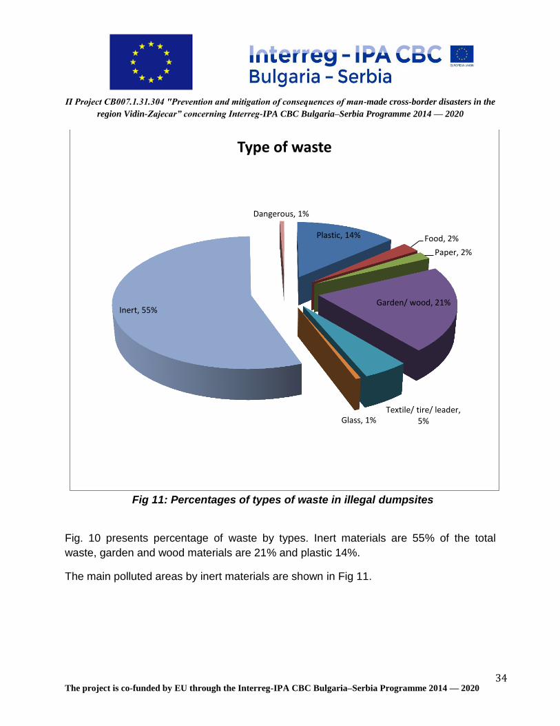
3.1. Akatsievo village ............................................................................................... 43
3.2. Antimovo village ............................................................................................... 43
3.3. Bela rada .......................................................................................................... 44
3.4. Botevo .............................................................................................................. 45
3.5. Bukovets ........................................................................................................... 46
3.6. Gaytantsi .......................................................................................................... 47
3.7. Gomotartsi ........................................................................................................ 48
3.8. Gradets ............................................................................................................. 49
3.9. Dinkovitsa ......................................................................................................... 50
3.10. Dunavtsi ........................................................................................................ 51
3.11. Zheglitsa ........................................................................................................ 52
3.12. Ivanovtsi ........................................................................................................ 53
3.13. Inovo ............................................................................................................. 53
3.14. Kalenik .......................................................................................................... 54
3.15. Kapitanovtsi ................................................................................................... 55
3.16. Koshava ........................................................................................................ 56
3.17. Kutovo ........................................................................................................... 57
3.18. Novoseltsi ...................................................................................................... 58
3.19. Pokrayna ....................................................................................................... 59
3.20. Ruptsi ............................................................................................................ 60

П Project CB007.1.31.304 "Prevention and mitigation of consequences of man-made cross-border disasters in the
region Vidin-Zajecar” concerning Interreg-IPA CBC Bulgaria–Serbia Programme 2014 — 2020
The project is co-funded by EU through the Interreg-IPA CBC Bulgaria–Serbia Programme 2014 — 2020 3
3.21. Sinagovtsi ...................................................................................................... 60
3.22. Slana Bara .................................................................................................... 61
3.23. Slanotran ....................................................................................................... 62
3.24. Tsar Simeonovo ............................................................................................ 63
4. Waste-related disaster risks in the Bulgaria-Serbian cross-border area ................. 64
4.1. Floods in 2013 .................................................................................................. 64
4.2. Floods in 2014 .................................................................................................. 65
4.3. Conclusions ...................................................................................................... 70
5. Environmental effects on the CBC area from the illegal dumps on the territory of the municipality of Vidin ....................................................................................................... 71
5.1. Air quality .......................................................................................................... 71
5.2. Surface and ground waters .............................................................................. 72
5.3. Soils .................................................................................................................. 72
5.4. Plants and wildlife ............................................................................................. 72
5.5. Aesthetic impact ............................................................................................... 72
5.6. Fires ................................................................................................................. 73
6. Health effects on the CBC area from the illegal dumps on the territory of the municipality of Vidin ....................................................................................................... 75
7. Economic effects on the CBC area from the illegal dumps on the territory of the municipality of Vidin ....................................................................................................... 77
8. Map of the illegal dumpsites on the territory of the municipality of Vidin ................. 80
9. Recommendations .................................................................................................. 82
10. Literature .............................................................................................................. 83
11. Annexes ............................................................................................................... 84
Annex 1- Tool for monitoring, control and reduction of the risk ...................................... 84
Annex 2- Map of illegal dumpsites ................................................................................. 87
List of figures
Fig 1: Map of Vidin - Zajecar cross-border region ............................................................ 7
Fig 2: Map of municipality of Vidin ................................................................................. 10
Fig 3: Map of municipality Zajecar ................................................................................. 14

П Project CB007.1.31.304 "Prevention and mitigation of consequences of man-made cross-border disasters in the
region Vidin-Zajecar” concerning Interreg-IPA CBC Bulgaria–Serbia Programme 2014 — 2020
The project is co-funded by EU through the Interreg-IPA CBC Bulgaria–Serbia Programme 2014 — 2020 4
Fig 4: Generated solid households waste, municipality Vidin, 2011-2016 ..................... 17
Fig 5: The share of morphological fraction in household waste for 2015,% ................... 24
Fig 6: The share of morphological fraction in household waste for 2015 in tons ........... 25
Fig 7: Classification of the settlement by number of illegal dumpsites .......................... 30
Fig 8: Distribution of the contaminated areas by size .................................................... 31
Fig 8: Distribution of the polluted areas by size and amount of waste ........................... 32
Fig 9: Classification of the settlement by total quantity of waste ................................... 33
Fig 10: Percentages of types of waste in illegal dumpsites ............................................ 34
Fig 11: Distribution of the inert materials by settlements ............................................... 35
Fig 12: Illegal waste dumpsites in Akatsievo village ...................................................... 43
Fig 13: Illegal waste dumpsites in Antimovo village ....................................................... 44
Fig 14: Illegal waste dumpsites in Bela Rada village ..................................................... 45
Fig 15: Illegal waste dumpsites in Botevo village ........................................................... 46
Fig 16: Illegal waste dumpsites in Bukovets village ....................................................... 47
Fig 17: Illegal waste dumpsites in Gaytantsi village ....................................................... 48
Fig 18: Illegal waste dumpsites in Gomotartsi village .................................................... 49
Fig 19: Illegal waste dumpsites in Gradets village ......................................................... 50
Fig 20: Illegal waste dumpsites in Dinkovitsa village ..................................................... 51
Fig 21: Illegal waste dumpsites in Dunavtsi city ............................................................. 51
Fig 22: Illegal waste dumpsites in Zheglitsa village ....................................................... 52
Fig 23: Illegal waste dumpsites in Ivanovtsi village ........................................................ 53
Fig 24: Illegal waste dumpsites in Inovo village ............................................................. 54
Fig 25: Illegal waste dumpsites in Kalenik village .......................................................... 54
Fig 26: Illegal waste dumpsites in Kapitanovtsi village .................................................. 55
Fig 27: Illegal waste dumpsites in Koshava village ........................................................ 56
Fig 28: Illegal waste dumpsites in Kutovo village ........................................................... 57
Fig 29: Illegal waste dumpsites in Novoseltsi village ..................................................... 58
Fig 30: Illegal waste dumpsites in Pokrayna village ....................................................... 59
Fig 31: Illegal waste dumpsites in Ruptsi village ............................................................ 60
Fig 32: Illegal waste dumpsites in Sinagotsi village ....................................................... 61
Fig 33: Illegal waste dumpsites in Slana Bara village .................................................... 62
Fig 34: Illegal waste dumpsites in Slanotran village ...................................................... 63

П Project CB007.1.31.304 "Prevention and mitigation of consequences of man-made cross-border disasters in the
region Vidin-Zajecar” concerning Interreg-IPA CBC Bulgaria–Serbia Programme 2014 — 2020
The project is co-funded by EU through the Interreg-IPA CBC Bulgaria–Serbia Programme 2014 — 2020 5
Fig 35: Illegal waste dumpsites in Tsar Simeonovo village ............................................ 63
Fig 36: Localized soil pollution sites in Serbia ............................................................... 69
Fig 37: Breakdown of activities causing local soil contamination [%] ............................ 70
Fig 38: Map of illegal dumpsites .................................................................................... 80
List of tables
Table I: Population of the municipality of Vidin, 2010 – 2016 ........................................ 11
Table II: Population by areas, 2016 ............................................................................... 12
Table III: Generated municipal waste in Vidin Municipality in ton per year for the period 2011-2016 ..................................................................................................................... 16
Table IV: Comparative table of the accumulation rate / collected household waste - kg/c/year.(data from NSI, *- no data) ............................................................................. 18
Table V: Morphological analysis of solid households’ waste, municipality Vidin ............ 18
Table VI: Morpholoical composition of the solid households waste average for each zone, 4 seasons in % .................................................................................................... 21
Table VII: The morphological composition of the solid household’s waste average for each zone, 4 seasons after reassessment of the “Other” fraction in % ......................... 22
Тable VIII: The quantities of generated waste, by fractions, municipality of Vidin, in tons ...................................................................................................................................... 23
Table IX: Data on the total amount of waste generated by fractions in Vidin municipality in tonnes and% with the quantities of separately collected recyclable fractions ............ 23
Table X: Polluted areas on the territory of municipality Vidin ......................................... 29
Table XI: Polluted areas on the territory of municipality Vidin and their location ............ 37
Table XII: Morphological analysis .................................................................................. 40
Table XIII: Data from NSI by year for the floods in Bulgaria and costs of the damages: 67
Table XIV Risk impact ................................................................................................... 73
Table XV Health assessment of contaminated areas .................................................... 75
Table XVI: Economic assessment- necessary financing for cleaning up activities ........ 79
Table XVII: Contaminated areas on the territory of municipality Vidin and their location 81
Table XVIII: Economic assessment- necessary financing for cleaning up activities in the priority areas .................................................................................................................. 82

П Project CB007.1.31.304 "Prevention and mitigation of consequences of man-made cross-border disasters in the
region Vidin-Zajecar” concerning Interreg-IPA CBC Bulgaria–Serbia Programme 2014 — 2020
The project is co-funded by EU through the Interreg-IPA CBC Bulgaria–Serbia Programme 2014 — 2020 6
1. Introduction
This report was developed by Energy Agency of Plovdiv under Project CB.007.1.31.304
“Prevention and mitigation of consequences of man - made cross - border disasters in
the region Vidin-Zajecar” concerning the Interreg IPA Cross-border Programme Bulgaria-
Serbia.
This report represents detailed research on the cross-border impact of illegal dumps on
the territory of the municipality of Vidin – one of the project objectives. The research was
carried out by the team of the following experts - Milena Agopyan, Liyana Adjarova,
Yonka Peshakova, Elka Piskova, Kiril Tunev, Nikola Balimezov, Hristo Minkov.
1.1. The aim and the scope of the study
The purpose of the study on the cross-border impact of illegal dumps on the territory of
the municipality of Vidin is to assess current waste management practices being
undertaken by Local Authorities and the waste industry within the Cross-Border Region,
as well as to identify opportunities for Local Authorities and the private sector to build
upon the experiences and waste management practices being implemented both in
Bulgaria and Serbia. This summary provides an overview of the key issues that have
been drawn out by the study and highlights the opportunities and challenges to be faced
by Government, Local Authorities and the waste industries if these issues are to be
addressed and cross-border opportunities are to be fully realised.
The main objectives of this study are:
To establish a baseline assessment of illegal dumpsites of undisputed data
quality for the settlements in the Vidin municipality;
As illegal dumpsites are a major nuisance for the citizens and visitors of Vidin
municipality, the final data shall also be used as an awareness-raising tool to
trigger a change in policy, management and social behavior.
To establish a process of data collection and monitoring that is owned and
followed up by cleaning activity from the municipality of Vidin and Ministry of
Environment and Water in Bulgaria.

П Project CB007.1.31.304 "Prevention and mitigation of consequences of man-made cross-border disasters in the
region Vidin-Zajecar” concerning Interreg-IPA CBC Bulgaria–Serbia Programme 2014 — 2020
The project is co-funded by EU through the Interreg-IPA CBC Bulgaria–Serbia Programme 2014 — 2020 7
1.2. The Cross-Border Context
The Bulgarian-Serbian border from the river Danube in the north down to the Bulgarian-
Serbian-Macedonian border triangle is approximately 220 km long. Most of the border
region is mountainous to alpine terrain, except for a short undulating and hilly terrain in
the northern part and a strip in the area where the main road from Sofia to Belgrade
passes. Most of the borderline coincides with the ridgeline of the Western Balkan
Mountains and has few road connections between both sides. There are only three
highways and two main roads crossing the border. High-capacity road and railway lines
connect Nish in Serbia and Sofia and in addition Skopje with Kyustendil and Sofia. Sofia
itself is an important traffic node in Southeastern Europe at the intersection of the axis
Belgrade – Sofia – Istanbul and Thessaloniki on the one hand and Skopje - Sofia –
Bucharest on the other hand.
Fig 1: Map of Vidin - Zajecar cross-border region
Most of the trans-border region is located in remote areas outside of dynamic economic
centers and, with the exception of Sofia, far away from big cities. This is another reason,
which makes cross-border cooperation traditionally more difficult. Job centers or
processing and industrial centers are not available and it is also not an option for

П Project CB007.1.31.304 "Prevention and mitigation of consequences of man-made cross-border disasters in the
region Vidin-Zajecar” concerning Interreg-IPA CBC Bulgaria–Serbia Programme 2014 — 2020
The project is co-funded by EU through the Interreg-IPA CBC Bulgaria–Serbia Programme 2014 — 2020 8
inhabitants to commute to the bigger central places on a daily basis. A big area of the
border region could be categorized as an economically underdeveloped rural area. A
common characteristic of the Bulgarian and Serbian border regions is their low
economic development compared to the remaining territories of both countries (IPA,
2007).
Border regions often have lower population density than the national average because
central places or big cities are usually not located in border areas. One exception is
Slovakia with its capital on the river Danube at the border with Austria. In the Bulgarian
border region, too, the population density is 1.5 times lower than the national average; in
Serbia it is 1.3 times lower.
The border area is characterized by its ethnic diversity, although ethnic Bulgarians and
Serbs form the core part of the population. Most of the people on the Serbian side of the
border are ethnic Serbs, in the Western Outlands ethnic Bulgarians. There is also a Vlah
minority (23 600 people) mostly living in the area of Bor, Boljevac, Negotin and Zaječar,
as well as some Macedonian and Montenegrin minorities, who are mainly concentrated
in Knjaževac, Zaječar, Negotin, Pirot, Dimitrovgrad and Surdulica on the Serbian side of
the border (Gigović, 2010).
Any self-declaration of ethnicity is controversial as this can have social and economic
implications. Also in this case there might be more ethnic Bulgarians in the Western
Outlands as declared in the statistics, due to some economic reasons as, for example,
work access or local business activity related to current regional development.
Part of the population of the Western Outlands has Bulgarian citizenship, which is a
clear advantage concerning travel and work permits within the EU and for traveling to
Bulgaria. The knowledge of the Bulgarian language gives the opportunity to have strong
social, economic and educational ties with Bulgaria. The knowledge of Serbian and
Bulgarian languages also is an advantage for many people who work in trade, legally
and illegally, between both countries.
On the Bulgarian side of the border, most of the people are ethnic Bulgarians; there is
also a significant Roma population, mainly in the city of Kyustendil, the village of Gorni
Lom and the city of Vidin. The share of the Roma population (4.7%) is more than three
times greater than on the Serbian side (1.4%) (IPA, 2007). There are also some villages
with a Vlach population in the region around Novo Selo.
П Project CB007.1.31.304 "Prevention and mitigation of consequences of man-made cross-border disasters in the
region Vidin-Zajecar” concerning Interreg-IPA CBC Bulgaria–Serbia Programme 2014 — 2020
The project is co-funded by EU through the Interreg-IPA CBC Bulgaria–Serbia Programme 2014 — 2020 9
The Serbian, Macedonian and Turkish population on the Bulgarian side of the border
has a limited representation in contrast to the rest of the country. There are only few
Serbians and Macedonians in the biggest cities of Kyustendil, Dragoman and
Belogradchik (Gigović,2010).
Population growth is often seen as an indicator for the long-term economic development
and attractiveness of a region for people and business. In both countries, strong
population declines over the last decades, especially in the border regions, have been
observed. The population decline of 0.57% in Bulgaria was the highest of all EU member
states in 2011. The decline in Serbia was less (0.33%), but still among the highest in
Europe, despite small net migration gains. In both countries, the population decline is
mainly caused by natural population loss. In Bulgaria, however, this is, in contrast to
Serbia, strengthened by a net outward migration.
1.3. Geographical and demographic characteristics of Vidin municipality
The region of Vidin includes 140 settlements and 11 municipalities - Vidin, Boynitsa,
Bregovo, Belogradchik, Gramada, Dimovo, Kula, Makresh, Novo Selo, Chuprene and
Ruzhintsi.
Municipality of Vidin is a mid-size Bulgarian municipality located in the north-west part of
the country, on the Danube River, close to the Romanian and Serbian borders. It covers
an area of 501.3 km2. By this indicator it ranks first among the 11 municipalities of the
Vidin region. The area of the municipality is 16.5% of the area, 2.6% of the area of the
Northwest region and 0.5% of the territory of Bulgaria.

П Project CB007.1.31.304 "Prevention and mitigation of consequences of man-made cross-border disasters in the
region Vidin-Zajecar” concerning Interreg-IPA CBC Bulgaria–Serbia Programme 2014 — 2020
The project is co-funded by EU through the Interreg-IPA CBC Bulgaria–Serbia Programme 2014 — 2020 10
Fig 2: Map of municipality of Vidin
The location of the municipal center Vidin on the banks of the Danube River puts the
municipality at the crossroads of two European transport corridors. The area under
investigation is the intersection of the Rhine - Main - Danube Corridor No 7, which
provides transport links between the Black Sea and the North Sea and Corridor 4
connecting Central with South - Eastern Europe. The strategic location of Vidin
Municipality over key European transport arteries and the presence of the Vidin port
create favorable opportunities for the economic development of the municipality at
national and international levels. The second bridge on the Danube (officially opened in
June 2013) is the most important for the development of the studied territory. Through
the bridge “New Europe” there is a road and rail transport link between the municipal
center Vidin and the Romanian city of Calafat.
The favorable geographic location of the regional and municipal center creates good
conditions for its differentiation as a transport and industrial unit in the northwestern part
of Bulgaria. Within the Vidin municipality there are two border checkpoints:

П Project CB007.1.31.304 "Prevention and mitigation of consequences of man-made cross-border disasters in the
region Vidin-Zajecar” concerning Interreg-IPA CBC Bulgaria–Serbia Programme 2014 — 2020
The project is co-funded by EU through the Interreg-IPA CBC Bulgaria–Serbia Programme 2014 — 2020 11
Vidin border checkpoint - River station - located in the central part of the regional
and municipal center – city of Vidin;
Danube Bridge 2 / Bridge “New Europe” / connecting the town of Vidin and the
city of Calafat.
The city of Vidin has a rich history as a cultural and touristic site, and has had a major
role in the production industries on the national level; however, in the last years the city
has suffered recession and companies have retreated from the region, which has also
led to migration of the young population. In this respect, the city is interested in
revitalizing its existing infrastructure and developing an attractive image for potential
investors. The city has developed an EE and RES strategy and action plan to increase
its energy efficiency in public buildings and facilities and public transport, and encourage
the introduction of RES capacities to answer the energy demands and increase its
energy independence. The municipality is involved in national and EU trans - border
cooperation projects.
According to the latest Census (2011) the population of Vidin municipality is 63 257
inhabitants - 62.6 % of the population of Vidin district.
The population of Vidin Municipality in December 2016 was 55 790 (according to NSI
data), which represents 62.78% of the total population of Vidin region.
Table I: Population of the municipality of Vidin, 2010 – 2016
Population by years
2011 2012 2013 2014 2015 2016
Vidin Region 99 481 97 546 95 467 93 361 91 235 88 867
Municipality of Vidin 62 348 61 416 60 222 59 039 57 001 55 790
The municipality of Vidin covers 34 settlements - two cities (city of Vidin and city of
Dunavtsi) and 32 villages (see Table II). The population in the municipality is decreasing
and this tendency has continued in recent years.

П Project CB007.1.31.304 "Prevention and mitigation of consequences of man-made cross-border disasters in the
region Vidin-Zajecar” concerning Interreg-IPA CBC Bulgaria–Serbia Programme 2014 — 2020
The project is co-funded by EU through the Interreg-IPA CBC Bulgaria–Serbia Programme 2014 — 2020 12
Table II: Population by areas, 2016
№ Area Population
1 City of Vidin 46 777
2 City of Dunavtsi 2 258
3 Akatsievo village 40
4 Antimovo village 433
5 Bela rada village 373
6 Botevo village 24
7 Bukovets village 571
8 Voinitsa village 37
9 Vartop village 34
10 Gaitantsi village 45
11 General Marinovo village 94
12 Gomotartsi village 491
13 Gradets village 1 083
14 Dinkovitsa village 75
15 Dolni Boshnyak village 44
16 Druzhba village 125
17 Zheglitsa village 119
18 Ivanovtsi village 54
19 Inovo village 466
20 Kalenik village 158
21 Kapitanovtsi village 843
22 Koshava village 287
23 Kutovo village 638
24 Mayor Uzunovo village 207
25 Novoseltsi village 636
26 Peshakovo village 57
27 Plakuder village 37
28 Pokrayna village 1 032
29 Ruptsi village 88
30 Sinagovtsi village 275
31 Slana bara village 294
32 Slanotran village 400
33 Tarnyane village 103
34 Tsar Simeonovo village 52

П Project CB007.1.31.304 "Prevention and mitigation of consequences of man-made cross-border disasters in the
region Vidin-Zajecar” concerning Interreg-IPA CBC Bulgaria–Serbia Programme 2014 — 2020
The project is co-funded by EU through the Interreg-IPA CBC Bulgaria–Serbia Programme 2014 — 2020 13
The population of Vidin Municipality is concentrated in the municipal center city of Vidin
with a share of 80.30% of the total population, as well as in the town of Dunavtsi -
3.88%, and the other three larger villages with population of about 1000 inhabitants.
1.4. Geographical and demographic characteristics of Zajecar municipality
The municipality of Zajecar is the central municipality of the Zajecar administrative
district, which includes four municipalities: Zajecar, Boljevac, Knjazevac and Sokobanja.
It is located in the central part of the Timocka Krajina and covers the Zajecar Basin, the
eastern part of Crnorečke and the northern part of the Knjazevac Basin, as well as the
southern parts of the Negotin Krajina. The territory of the municipality is bordered: from
the north slopes of the mountain Deli Jovan, from the east and southeast slopes of Stara
Planina mountain range, which goes to the state border of Bulgaria, in the south and
southwest of Lasovačka mountain as a branch of Tupižnica mountain, and in the west
by Ježević and the branches of Veliki Krša.
The municipality of Zajecar comprises 42 settlements, with a total population of 59 461
inhabitants, Zaječar (38 165 inhabitants) and 41 villages (21 296): Borovac (114),
Brusnik (315), Velika Jasikova (819), Veliki Izvor (2.399), Veliki Jasenovac (287),
Vražogrnac (1.096), Vratarnica (457), Vrbica (205), Gamzigrad (683), Glogovica (387),
Gornja Bela Reka (122), Gradskovo (504), Grlište (697), Grljan (2.379), Dubočane
(365), Zagrađe (167), Zvezdan (1.602), Jelašnica (100), Klenovac (172), Koprivnica
(420), Lasovo (245), Lenovac (147), Leskovac (80), Lubnica (808), Mala Jasikova
(235), Mali Izvor (372), Mali Jasenovac (232), Marinovac (209), Metriš (273),
Nikoličevo (715), Planinica (205), Prlita (90), Rgotina (1.452), Salaš (688), Selačka
(208), Tabakovac (170), Trnovac (391), Halovo (707), Čokonjar (143), Šipikovo (383),
Šljivar (253). Source of data is RZS Serbia (Census 2011).
The municipality occupies an area of 1 069 km2, of which 63.7% is agricultural land
(data for 2011, RZS Serbia). In this area are 59 461 inhabitants, according to the 2011
population census (Census 2011). The number of households is 21 031 and the
average number of household members is 2.83. The population density is 56 inhabitants
per km2 and is the largest in the Zajecar district and the second largest in the whole

П Project CB007.1.31.304 "Prevention and mitigation of consequences of man-made cross-border disasters in the
region Vidin-Zajecar” concerning Interreg-IPA CBC Bulgaria–Serbia Programme 2014 — 2020
The project is co-funded by EU through the Interreg-IPA CBC Bulgaria–Serbia Programme 2014 — 2020 14
Timok region. In the city of Zajecar live 38 165 inhabitants (64.18%) and in other 41
settlements live 21 296 inhabitants (35.81%).
Fig 3: Map of municipality Zajecar
2. Past experience and problems with illegal dumpsites in the
municipality of Vidin
Lifestyles due to the growth of the population's welfare generate an increasingly
household solid waste. The lack of collecting and treating waste generated in the last
decade has created a bad image of aesthetic and environmental pollution. Waste
management has not yet been reached to cover the whole country. The lack of a waste
management system in Bulgaria is attributed to a number of factors:
the lack of network management,
lack of technical and financial means,
low rate payment, and
lack of waste law implementation.

П Project CB007.1.31.304 "Prevention and mitigation of consequences of man-made cross-border disasters in the
region Vidin-Zajecar” concerning Interreg-IPA CBC Bulgaria–Serbia Programme 2014 — 2020
The project is co-funded by EU through the Interreg-IPA CBC Bulgaria–Serbia Programme 2014 — 2020 15
2.1. Review of the municipal waste management program of municipality of Vidin
2.1.1. Common information
The new Regional municipal landfill for all 11 municipalities in the Vidin region has been
in operation since 2015.
Vidin Municipality fully complies with the requirements for landfill disposal at landfills
meeting European and national requirements. The municipality has ensured the
ecological disposal of the Regional Landfill for non-hazardous waste for the
municipalities of Vidin, Belogradchik, Boynitsa, Bregovo, Gramada, Dimovo, Kula,
Makresh, Novo Selo, Rujintsi and Chuprene, based on the Integrated permit (КР № 389
– Н0/2010) issued by the Ministry of Environment and Water, according to the provisions
in art.117 of Environmental Protection Act.
For the municipality of Vidin the value of the indicator rate of accumulation (represented
as the amount of generated household waste per year per capita) for 2016 is 317 kg per
capita per year (kg/cap/y). This value is less than the values for settlements with a
population of 50,000 to 150,000 inhabitants – 349,6 kg /cap/ y.
The municipality decides the issues of construction and demolition waste by transporting
and treating them through an installation for crushing and screening of construction
waste located in the southernmost part of the Regional Non-hazardous Waste Depot for
the municipalities of Vidin, Belogradchik, Boynitsa, Bregovo, Gramada, Dimovo, Kula,
Makresh, Novo Selo, Rujintsi and Chuprene. The installation has a maximum annual
capacity for receiving and treating 80 000 t of construction waste. Installations for
crushing and screening of construction waste are not yet operational.
For the purpose of environmentally friendly collection and recovery of packaging waste,
the Vidin Municipality has a contract with a recovery organisation and has organised a
system for the separate collection of recyclable fractions (paper and cardboard, glass,
plastic).
Data from the morphological analysis show the share of household biowaste (food,
garden, wood) - in 2016, the quantity is 5 667,3 tonnes, or 33,74% of total (Table V to
Table IX, Figures 5 and 6) generated solid household waste in the municipality. In order
to achieve the Municipality's objective of reducing the amount of landfilled household
bio-waste through separate collection and recycling in the Regional Non-hazardous
Waste Depot for the municipalities Vidin, Belogradchik, Boynitsa, Bregovo, Gramada,

П Project CB007.1.31.304 "Prevention and mitigation of consequences of man-made cross-border disasters in the
region Vidin-Zajecar” concerning Interreg-IPA CBC Bulgaria–Serbia Programme 2014 — 2020
The project is co-funded by EU through the Interreg-IPA CBC Bulgaria–Serbia Programme 2014 — 2020 16
Dimovo, Kula, Makresh, Novo Selo, Rujintsi and Chuprene a composting plant operates
- with maximum annual capacity for receiving and treating 10 000 t of biodegradable
waste; the composting plant includes the treatment of biodegradable green and
municipal waste generated on the territory of Vidin and Belogradchik. The municipality of
Vidin has started a phased introduction of a system for the separate collection and
utilization of “green” waste from parks and gardens and from households. During 2016,
46, 58 tons of biodegradable wastes were accepted at the regional landfill.
2.1.2. Waste analyses
In Table III and Fig. 3 are presented the quantities of municipal solid waste generated on
the territory of Vidin Municipality during the investigation period 2011-2016.
Table III: Generated municipal waste in Vidin Municipality in ton per year for the period 2011-2016
Quantities of mixed municipal waste, in tons per year
Type of waste 2011 2012 2013 2014 2015 2016
Mixed households
waste in
municipality Vidin
26 577 26 080 25 225 26 020 17 142 17 664

П Project CB007.1.31.304 "Prevention and mitigation of consequences of man-made cross-border disasters in the
region Vidin-Zajecar” concerning Interreg-IPA CBC Bulgaria–Serbia Programme 2014 — 2020
The project is co-funded by EU through the Interreg-IPA CBC Bulgaria–Serbia Programme 2014 — 2020 17
Fig 4: Generated solid households waste, municipality Vidin, 2011-2016
As can be seen from Fig. 4, for the period 2011-2014, there were no changes in the
quantity of generated solid household waste on the territory of the municipality.
Quantities decreased sharply from 2015 after the commissioning of the regional waste
management system and the weighing of the quantity of generated solid households
waste on the territory of the municipality.
An important indicator of waste management is the rate of accumulation of waste,
expressed as the amount of household waste generated per year per capita. Table IV
presents the comparison of cumulative accumulation rates for Bulgaria, district Vidin and
municipality Vidin, for the period 2011-2015. According to the Ministry of Environment
and Waters (MoEW) and the National program for waste management 2014-2020, the
accumulation rate for the period 2012-2015 for settlements with a population of less than
3 000 inhabitants is 241,7 kg/cap/year, and for settlements with a population of 25 000
to 50 000 inhabitants is 334,9 kg/cap/year. The average value of the accumulation rate
for Vidin municipality for 2015 is 301 kg/cap/year and for 2016 - 317 kg/cap/year.

П Project CB007.1.31.304 "Prevention and mitigation of consequences of man-made cross-border disasters in the
region Vidin-Zajecar” concerning Interreg-IPA CBC Bulgaria–Serbia Programme 2014 — 2020
The project is co-funded by EU through the Interreg-IPA CBC Bulgaria–Serbia Programme 2014 — 2020 18
Table IV: Comparative table of the accumulation rate / collected household waste - kg/c/year.(data from NSI, *- no data)
2011 2012 2013 2014 2015 2016
For Bulgaria 380 347 434 443 420 *
Region Vidin 337 314 315 330 243 *
Municipality of
Vidin
426 425 419 441 301 317
Between February and November 2016 a morphological analysis of the composition and
quantities of municipal solid waste was carried out. The analysis was carried out
according to the requirements of the Methodology for determining the morphological
composition of household waste, approved by the Ministry of Environment and Water in
2012. The analysis data for the individual seasons, as well as the average annual
values, are presented in Tables V to IX and Figures 5 and 6.
Table V: Morphological analysis of solid households’ waste, municipality Vidin
a) Morphological analysis, area city of Vidin, high - rise buildings, 4 seasons
Morphological fraction
sample “summer”
sample “autumn” sample “winter” sample “spring”
Weight, kg
Morphological fraction, % Weight,
kg
Morphological fraction, % Weight, kg Morphological
fraction % Weight, kg
Morphological fraction, %
Food 23,5 19,1 17,5 14,0 28,0 22,4 23,9 20,0
Paper and cardboard
20,4 16,6 15,0 12,0 16,8 13,5 16,8 14,0
Plastic 18,9 15,4 22,0 17,6 13,3 10,6 24,5 20,4
Textile 6,6 5,4 6,7 5,4 3,3 2,6 2,9 2,4
Tire 0,8 0,6 1,6 1,3 1,2 1,0 0,3 0,2
Leader 3,3 2,7 1,5 1,2 0,0 0,0 0,3 0,2
Garden 8,4 6,9 9,0 7,2 2,1 1,7 2,4 2,0

П Project CB007.1.31.304 "Prevention and mitigation of consequences of man-made cross-border disasters in the
region Vidin-Zajecar” concerning Interreg-IPA CBC Bulgaria–Serbia Programme 2014 — 2020
The project is co-funded by EU through the Interreg-IPA CBC Bulgaria–Serbia Programme 2014 — 2020 19
Wood 2,3 1,8 2,2 1,8 0,0 0,0 0,0 0,0
Glass 4,7 3,8 12,0 9,6 13,3 10,6 10,9 9,1
Inert 2,0 1,6 5,5 4,4 1,2 1,0 3,5 2,9
Metals 2,5 2,0 4,1 3,3 4,5 3,6 0,5 0,4
Hazardous 2,6 2,1 1,9 1,5 0,4 0,4 0,8 0,7
Other 27,0 21,9 26,0 20,8 41,0 32,8 33,3 27,7
Total 123,00 100,00 126,00 100,00 125,00 100,00 120,00 100,00
b) Morphological analysis, area city of Vidin, single-family buildings, 4 seasons
Morphological fraction
sample “summer”
sample “autumn” sample “winter” sample “spring”
Weightkg
Morphological
fraction, % Weight
kg
Morphological
fraction, % Weight
kg
Morphological fraction
% Weight
kg
Morphological
fraction, %
Food 13,4 11,1 17,6 14,2 23,4 18,6 12,3 9,8
Paper and cardboard
11,7 9,7 5,0 4,1 8,8 7,0 11,2 8,9
Plastic 19,2 15,9 20,3 16,4 19,7 15,6 21,8 17,4
Textile 8,1 6,7 5,4 4,3 2,0 1,6 6,2 4,9
Tire 1,7 1,4 0,0 0,0 0,0 0,0 0,8 0,7
Leader 2,5 2,1 0,0 0,0 0,0 0,0 0,6 0,4
Garden 20,5 16,9 24,2 19,5 7,7 6,1 12,6 10,1
Wood 3,1 2,6 0,0 0,0 0,0 0,0 5,0 4,0
Glass 8,1 6,7 1,7 1,4 4,3 3,4 3,9 3,1
Inert 3,6 3,0 11,4 9,2 13,1 10,4 12,3 9,8
Metals 2,0 1,7 3,6 2,9 2,6 2,0 0,6 0,4
Hazardous 1,8 1,5 3,9 3,1 6,0 4,8 1,1 0,9
Other 25,4 21,0 31,0 25,0 38,5 30,5 36,6 29,3
Total 121,0 100 124 100 126 100 125 100

П Project CB007.1.31.304 "Prevention and mitigation of consequences of man-made cross-border disasters in the
region Vidin-Zajecar” concerning Interreg-IPA CBC Bulgaria–Serbia Programme 2014 — 2020
The project is co-funded by EU through the Interreg-IPA CBC Bulgaria–Serbia Programme 2014 — 2020 20
c) Morphological analysis, area villages, 4 seasons
Morphological fraction
sample “summer”
sample “autumn” sample “winter” sample “spring”
Weight kg
Morphological
fraction, %
Weight kg
Morphological
fraction, %
Weight kg
Morphological
fraction %
Weight kg
Morphological
fraction, %
Food 15,4 12,4 15,8 13,2 14,0 11,2 13,3 10,9
Paper and cardboard
8,1 6,5 5,4 4,5 8,4 6,7 4,8 3,9
Plastic 24,3 19,6 16,6 13,9 25,6 20,5 25,6 20,9
Textile 5,8 4,7 15,8 13,2 14,8 11,9 7,2 5,9
Tire 0,5 0,4 4,7 4,0 1,5 1,2 0,7 0,6
Leader 3,8 3,1 0,8 0,7 0,0 0,0 0,3 0,3
Garden 25,8 20,8 22,6 18,8 14,5 11,6 16,7 13,7
Wood 0,0 0,0 10,4 8,7 0,0 0,0 0,0 0,0
Glass 7,4 6,0 0,8 0,7 3,2 2,6 1,4 1,1
Inert 4,4 3,5 7,2 6,0 4,9 3,9 12,3 10,1
Metals 4,3 3,5 1,2 1,0 1,0 0,8 4,8 3,9
Hazardous 2,1 1,7 1,8 1,5 1,2 0,9 1,7 1,4
Other 22,0 17,8 16,6 13,9 35,9 28,7 33,4 27,4
Total 124,0 100,0 120,0 100,0 125,0 100,0 122,0 100,0

П Project CB007.1.31.304 "Prevention and mitigation of consequences of man-made cross-border disasters in the
region Vidin-Zajecar” concerning Interreg-IPA CBC Bulgaria–Serbia Programme 2014 — 2020
The project is co-funded by EU through the Interreg-IPA CBC Bulgaria–Serbia Programme 2014 — 2020 21
Table VI: Morpholoical composition of the solid households waste average for
each zone, 4 seasons in %
Morphological fraction
City of Vidin, high- rise
buildings, %
City of Vidin, single family residential
buildings, %
Area - villages, %
Average for the
municipality, %
Food 18,87 13,41 11,93 13,40
Paper and cardboard
14,00 7,42 5,42 7,30
Plastic 16,00 16,34 18,72 17,49
Textile 3,96 4,38 8,90 6,58
Tire 0,77 0,51 1,53 1,06
Leader 1,02 0,62 1,01 0,87
Garden 4,44 13,15 16,22 13,52
Wood 0,90 1,65 2,17 1,81
Glass 8,28 3,63 2,58 3,72
Inert 2,47 8,11 5,88 6,24
Metals 2,33 1,76 2,30 2,11
Hazardous 1,17 2,56 1,40 1,79
Other 25,80 26,46 21,93 24,11
Total 100,0 100,0 100,0 100,00
It is clear from the above table that the largest fraction of household waste is occupied by the plastic fraction - 17.49%, followed by “garden” - 13.52% and “food” - 13.40%, “paper and cardboard” - 7.30 %. The share of category “others” is 24.11%. It is worth mentioning the large share of the textile fraction - 6.58%, with the average for the country 3.0%.
Waste identified as “other” is an indeterminable waste which, due to its small size and shape, cannot be separated and weighed. This indeterminable waste is often in quite a large quantity, especially when it has passed a lorry with a compaction device and could reach 50%, and should not be neglected. According to the recommendations given in the Methodology for determining the morphological composition of municipal waste for

П Project CB007.1.31.304 "Prevention and mitigation of consequences of man-made cross-border disasters in the
region Vidin-Zajecar” concerning Interreg-IPA CBC Bulgaria–Serbia Programme 2014 — 2020
The project is co-funded by EU through the Interreg-IPA CBC Bulgaria–Serbia Programme 2014 — 2020 22
the re-evaluation of the fraction “others”, it contains about 65% ash (ash from solid fuels, earth, sap) and about 25% biodegradable waste.
Data from the morphological analysis performed after reassessment of the “other” fraction are presented in Table VII.
Table VII: The morphological composition of the solid household’s waste average for each zone, 4 seasons after reassessment of the “Other” fraction in %
Morphological fraction
City of Vidin- average value, %
Area- villages, %
Average for the
municipality, %
Food 18,02 14,56 16,29
Paper and cardboard 10,23 6,30 8,26
Plastic 16,78 19,16 17,97
Textile 4,53 9,12 6,83
Tire 0,58 1,53 1,06
Leader 0,73 1,01 0,87
Garden 12,93 17,97 15,45
Wood 1,66 2,34 2,00
Glass 6,50 3,94 5,22
Inert 18,73 19,92 19,32
Metals 7,13 2,74 4,94
Hazardous 2,19 1,40 1,79
Total 100,0 100,0 100,0

П Project CB007.1.31.304 "Prevention and mitigation of consequences of man-made cross-border disasters in the
region Vidin-Zajecar” concerning Interreg-IPA CBC Bulgaria–Serbia Programme 2014 — 2020
The project is co-funded by EU through the Interreg-IPA CBC Bulgaria–Serbia Programme 2014 — 2020 23
Тable VIII: The quantities of generated waste, by fractions, municipality of Vidin, in tons
Morphological fraction
Average f or city of Vidin, t
Area - villages, t Average for
the municipality, t
Food 2 472,21 498,38 2 970,58
Paper and cardboard 1 402,89 215,66 1 618,55
Plastic 2 301,30 656,01 2 957,31
Textile 620,96 312,37 933,33
Tire 79,67 52,48 132,15
Leader 100,09 34,58 134,67
Garden 1 773,61 615,36 2 388,98
Wood 227,44 80,27 307,71
Glass 891,86 134,81 1 026,67
Inert 2 569,87 681,81 3 251,68
Metals 978,40 93,87 1 072,26
Hazardous 300,16 47,95 348,11
Total 13 718,47 3 423,53 17 142,00
Table IX: Data on the total amount of waste generated by fractions in Vidin municipality in tonnes and% with the quantities of separately collected recyclable
fractions
Morphological fraction
Average f or city of Vidin, t
Area- villages, t Average for the municipality, t
Average for the municipality, %
Food 2545,16 498,4 3043,5 17,03
Paper and cardboard
1466,57 215,7 1682,2 9,41
Plastic 2360,91 656,0 3016,9 16,88
Textile 627,04 312,4 939,4 5,26

П Project CB007.1.31.304 "Prevention and mitigation of consequences of man-made cross-border disasters in the
region Vidin-Zajecar” concerning Interreg-IPA CBC Bulgaria–Serbia Programme 2014 — 2020
The project is co-funded by EU through the Interreg-IPA CBC Bulgaria–Serbia Programme 2014 — 2020 24
Tire 79,67 52,5 132,1 0,74
Leader 100,09 34,6 134,7 0,75
Garden 1822,25 615,4 2437,6 13,64
Wood 232,30 80,3 312,6 1,75
Glass 965,28 134,8 1100,1 6,16
Inert 2958,95 681,8 3640,8 20,37
Metals 990,55 93,9 1084,4 6,07
Hazardous 300,16 47,9 348,1 1,95
Total 14 448,95 3 423,5 17 872,5 100,00
Fig 5: The share of morphological fraction in household waste for 2015,%
33.74%
8.26%
17.97%
8.76%
5.22%
19.32%
4.94% 1.79%
Food, garden,woodPaper andcardboardPlastic
Textile, tire,leatherGlass
Inert
Metals
Hazardous

П Project CB007.1.31.304 "Prevention and mitigation of consequences of man-made cross-border disasters in the
region Vidin-Zajecar” concerning Interreg-IPA CBC Bulgaria–Serbia Programme 2014 — 2020
The project is co-funded by EU through the Interreg-IPA CBC Bulgaria–Serbia Programme 2014 — 2020 25
Fig 6: The share of morphological fraction in household waste for 2015 in tons
2.2. Past experience of the municipality Vidin with the illegal dumpsites
In 2015 the municipality of Vidin identified illegal dumps on its territory. The polluted
areas were situated in villages Botevo, Vartop, Gaytantsi, Ivanovtsi, Sinagovtsi, Bela
Rada, Voynitsa, General Marinovo, Peshakovo, Slana Bara, Tarnyane, Akatsievo,
Gradets, Dinkovitsa, Dolni Boshnyak, DrujbaPlakuder, Ruptsi, Antimovo, Gomotartsi,
Inovo, Kapitanovtsi, Koshava, Kutovo, Pokrayna and Slanotran. The municipality of Vidin
cleaned the polluted areas in 2016.
In 2018 the experts from the Energy Agency of Plovdiv identified the polluted areas in
the municipality Vidin by visiting the settlements. The Vidin municipality has more than
30 settlements with household-waste-polluted territories that need to be cleaned
regularly to reduce the risk of disasters caused by contamination from human activity. By
providing the pictures from polluted areas, the municipality of Vidin could undertake
5667.27
1618.55
2957.31
1200.15
1026.67
3251.68
1072.26 348.11 Food, garden, wood
Paper andcardboard
Plastic
Textile, tire, leather
Glass
Inert
Metals
Hazardous

П Project CB007.1.31.304 "Prevention and mitigation of consequences of man-made cross-border disasters in the
region Vidin-Zajecar” concerning Interreg-IPA CBC Bulgaria–Serbia Programme 2014 — 2020
The project is co-funded by EU through the Interreg-IPA CBC Bulgaria–Serbia Programme 2014 — 2020 26
additional measures to ensure the ecological balance in the municipality and the
prevention of risks of various disasters related to pollution and dumps as a whole.
2.3. Identified illegal dumpsites on the territory of Vidin municipality
The experts from Energy Agency of Plovdiv during the visits to the illegal dumpsites
conducted morphological analysis of the composition and quantities of the solid waste.
The analysis is carried out according to the requirements of the Methodology for
determining the morphological composition of household waste approved by the Ministry
of Environment and Water in 2012. The analysis data for the each site are described
below.
The areas/lands around the landfill have greater risk for contamination of groundwater.
Many of the products that have toxic origin and heavy metals, such as arsenic, zinc,
copper, and selenium, are harmful to the environment. In the most common case urban
wastes are disposed into landfills, which were originally located relatively close to the
urban areas. This means that a huge amount of waste could be burned, disposed of
through the rivers or in inappropriate places as illegal dumpsites.
The Waste Management Act in Bulgaria (Promulgated, State Gazette No.
53/13.07.2012, effective 13.07.2012, amended, SG No. 66/26.07.2013, effective
26.07.2013; Judgment No. 11/10.07.2014 of the Constitutional Court of the Republic of
Bulgaria - SG No. 61/25.07.2014; amended, SG No. 98/28.11.2014, effective
28.11.2014, SG No. 14/20.02.2015, amended and supplemented, SG No.
105/30.12.2016, SG No. 13/7.02.2017) determines:
Article 19
(3) The municipality mayor shall be responsible for:
15. prevention of the dumping of waste in places unauthorised for this purpose
and/or of the establishment of illegal dumping sites and ensuring their removal.
Article 29
(1) Waste, depending on its type, properties, composition and other characteristics, shall
be collected, transported and treated in a manner not impeding its further recovery.

П Project CB007.1.31.304 "Prevention and mitigation of consequences of man-made cross-border disasters in the
region Vidin-Zajecar” concerning Interreg-IPA CBC Bulgaria–Serbia Programme 2014 — 2020
The project is co-funded by EU through the Interreg-IPA CBC Bulgaria–Serbia Programme 2014 — 2020 27
(2) The abandonment, unauthorised dumping and incineration or any other form of
uncontrolled waste management shall be prohibited
Article 112
(1) The municipal mayor or an official authorised thereby shall exercise control over:
1. operations relating to the generation, collection, including separate collection,
storage, transport and treatment of household and construction and demolition
waste;
Article 133
(1) A fine of BGN 300 or exceeding this amount but not exceeding BGN 1,000 shall be
imposed on any natural person who:
1. discards waste in places unauthorized for this purpose;
Article 151
(2) A fine of BGN 3,000 or exceeding this amount but not exceeding BGN 10,000 shall
be imposed on any municipal mayor and/or an official, unless subject to a severer
sanction, who:
6. fails to take measures for prevention of the dumping of waste in places unauthorised
for this purpose and/or of the establishment of illegal dumping sites and ensuring their
removal;
2.3.1. Methodology
In order to ensure a collection of reliable baseline data comparable across municipalities,
experts from the Energy Agency of Plovdiv were engaged in data collection and data
collection methodology. For this assessment, the following were applied:
Scope: All the populated settlements in the Vidin municipality were visited and the
pollutant areas were evaluated. A routing had been agreed on with the experts from
municipality of Vidin, in advance, to ensure an efficient assessment.
Data collection: The following data points of each dumpsite were collected:

П Project CB007.1.31.304 "Prevention and mitigation of consequences of man-made cross-border disasters in the
region Vidin-Zajecar” concerning Interreg-IPA CBC Bulgaria–Serbia Programme 2014 — 2020
The project is co-funded by EU through the Interreg-IPA CBC Bulgaria–Serbia Programme 2014 — 2020 28
- Photo proof: Each dumpsite was photographed. Panoramic or multiple pictures were taken when necessary.
- Geo-reference: Each dumpsite was geo - referenced by the indication of Latitude and Longitude. The decimal second was indicated (e.g., 43°56’07”) and when was possible the contaminated territories were described by name.
- Municipality: The name of the municipality where the dumpsite has been found was indicated.
- Risks: 3 levels of risks were determined: 1- low, 2- medium, 3- high
- Amount: The experts defined the amount of the waste in the dumpsites:
Small: 1-20 m3
Medium: 20-200 m3
Big: > 200 m3
- Size: The experts defined the size of contaminated area:
1-49 m²; i.e. up to 7m x 7m or the like 50-400 m², i.e. up to 20 x 20 m or the like >400 m²
- Fractions: Data collectors were indicated as one or more of the following:
Plastic waste Food waste Paper waste Garden/ wood waste Textile, tires, leader waste Glass waste Inert/construction waste Hazardous waste
2.3.2. Results
For a month, two teams conducted an investigation and identification of illegal
landfills in 30 settlements on the territory of the municipality Vidin. In total, 46 illegal
dumpsites were identified in 24 settlements. Polluted areas cover more than 45 000 m2,
with more than 20 000 m3 of waste.

П Project CB007.1.31.304 "Prevention and mitigation of consequences of man-made cross-border disasters in the
region Vidin-Zajecar” concerning Interreg-IPA CBC Bulgaria–Serbia Programme 2014 — 2020
The project is co-funded by EU through the Interreg-IPA CBC Bulgaria–Serbia Programme 2014 — 2020 29
The identified polluted areas, the number of illegal dumpsites in each settlement, the
quantity of waste and the polluted areas are shown in Table X:
Table X: Polluted areas on the territory of municipality Vidin
№ Settlement Number of
illegal dumpsites
Contaminatedarea (in m²)
Amount of waste (in m³)
Waste weight (kg)
1 Akatsievo 1 30 20 242
2 Antimovo 1 30 20 102
3 Bela Rada 1 10 30 134
4 Botevo 1 20 20 58
5 Bukovets 4 6 250 600 2 445
6 Gaytantsi 2 130 15 127
7 Gomotartsi 5 1 300 1 030 2 232
8 Gradetс 4 1 470 260 885
9 Dinkovitsa 1 150 50 3 030
10 Dunavtsi 2 220 40 505
11 Zheglitsa 1 1 200 1 580 3 420
12 Ivanovtsi 1 30 20 311
13 Inovo 2 6 005 315 1 213
14 Kalenik 3 390 75 2 132
15 Kapitanovtsi 2 8 015 5 020 4 612
16 Koshava 1 3 000 1 000 3 145
17 Kutovo 2 8 000 4 000 6 855
18 Novoseltsi 2 1 900 100 422
18 Pokrayna 1 2 500 20 4 180
20 Ruptsi 1 50 30 770
21 Sinagovtsi 1 2 000 3 000 2 980
22 Slana Bara 1 20 15 377
23 Slanotran 2 40 45 134
24 Tsar Simeonovo 1 100 18 202
Total: 43 42 860 17 323 40 513

П Project CB007.1.31.304 "Prevention and mitigation of consequences of man-made cross-border disasters in the
region Vidin-Zajecar” concerning Interreg-IPA CBC Bulgaria–Serbia Programme 2014 — 2020
The project is co-funded by EU through the Interreg-IPA CBC Bulgaria–Serbia Programme 2014 — 2020 30
In the Fig. 7 the total number of illegal dumpsites for all of the settlements in municipality
Vidin is conducted.
Fig 7: Classification of the settlement by number of illegal dumpsites
According to the results in Fig.7, the territories of 24 settlements contained a large
number of illegal dumpsites. This number ranges from 1- 5 with illegal dumpsites. The
0 1 2 3 4 5 6
Akatsievo
Antimovo
Bela Rada
Botevo
Bukovets
Gaytantsi
Gomotartsi
Gradetс
Dinkovitsa
Dunavtsi
Zheglitsa
Ivanovtsi
Inovo
Kalenik
Kapitanovtsi
Koshava
Kutovo
Novoseltsi
Pokrayna
Ruptsi
Sinagovtsi
Slana bara
Slanotran
Tsar Simeonovo
Number
Number of illegal dumpsites in the settlements

П Project CB007.1.31.304 "Prevention and mitigation of consequences of man-made cross-border disasters in the
region Vidin-Zajecar” concerning Interreg-IPA CBC Bulgaria–Serbia Programme 2014 — 2020
The project is co-funded by EU through the Interreg-IPA CBC Bulgaria–Serbia Programme 2014 — 2020 31
settlements that have the most illegal dumpsites are: Gomotartsy, Gradets and
Bukovets.
Fig 8: Distribution of the contaminated areas by size
0 1 000 2 000 3 000 4 000 5 000 6 000 7 000 8 000 9 000
Akatsievo
Antimovo
Bela Rada
Botevo
Bukovets
Gaytantsi
Gomotartsi
Gradetс
Dinkovitsa
Dunavtsi
Zheglitsa
Ivanovtsi
Inovo
Kalenik
Kapitanovtsi
Koshava
Kutovo
Novoseltsi
Pokrayna
Ruptsi
Sinagovtsi
Slana bara
Slanotran
Tsar Simeonovo
Distribution of the contaminated areas by size
Contaminated area (in m²)

П Project CB007.1.31.304 "Prevention and mitigation of consequences of man-made cross-border disasters in the
region Vidin-Zajecar” concerning Interreg-IPA CBC Bulgaria–Serbia Programme 2014 — 2020
The project is co-funded by EU through the Interreg-IPA CBC Bulgaria–Serbia Programme 2014 — 2020 32
The total contaminated area is 42 860 m2. The biggest contaminated areas were
identified in the villages Kutovo, Kapitanovtsi, Inovo and Bukovets.
Fig 9: Distribution of the polluted areas by size and amount of waste
Figure 8 presents distribution of the polluted areas in the settlement by surface (in m2)
and quantity of waste-- both in m3 and kg. Sometimes a small quantity of waste
occupied a large area, as in villages Inovo and Bukovets. In other cases a large amount
of waste could occupy a small area - as in the Pokrayna village.
Local policies should be focused on limiting contaminated sites and clearing up larger
illegal dumpsites.
0
1 000
2 000
3 000
4 000
5 000
6 000
7 000
8 000
9 000
Distribution of the contaminated areas by size and amount of waste
Total polluted area for the settlement (in m²) Amaunt of waste (in m³)
Waste weight in the settlemet (kg)

П Project CB007.1.31.304 "Prevention and mitigation of consequences of man-made cross-border disasters in the
region Vidin-Zajecar” concerning Interreg-IPA CBC Bulgaria–Serbia Programme 2014 — 2020
The project is co-funded by EU through the Interreg-IPA CBC Bulgaria–Serbia Programme 2014 — 2020 33
Fig 10: Classification of the settlement by total quantity of waste
In Fig. 9, the percentage of illegal dumpsites has been categorized based on the amount
of waste calculated in kg and m3. The largest amount, with 29%, was registered in
Kapitanovtsi village.
0% 5% 10% 15% 20% 25% 30% 35%
Akatsievo
Antimovo
Bela Rada
Botevo
Bukovets
Gaytantsi
Gomotartsi
Gradetс
Dinkovitsa
Dunavtsi
Zheglitsa
Ivanovtsi
Inovo
Kalenik
Kapitanovtsi
Koshava
Kutovo
Novoseltsi
Pokrayna
Ruptsi
Sinagovtsi
Slana bara
Slanotran
Tsar Simeonovo
Percent distribution of the settlement by contaminated area and amaunt of waste
Amaunt of waste (in m³) Waste weight (kg)
П Project CB007.1.31.304 "Prevention and mitigation of consequences of man-made cross-border disasters in the
region Vidin-Zajecar” concerning Interreg-IPA CBC Bulgaria–Serbia Programme 2014 — 2020
The project is co-funded by EU through the Interreg-IPA CBC Bulgaria–Serbia Programme 2014 — 2020 34
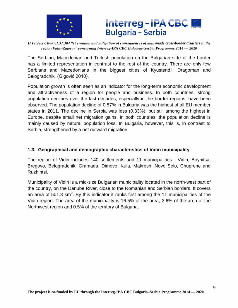
Fig 11: Percentages of types of waste in illegal dumpsites
Fig. 10 presents percentage of waste by types. Inert materials are 55% of the total
waste, garden and wood materials are 21% and plastic 14%.
The main polluted areas by inert materials are shown in Fig 11.
Plastic, 14% Food, 2%
Paper, 2%
Garden/ wood, 21%
Textile/ tire/ leader, 5% Glass, 1%
Inert, 55%
Dangerous, 1%
Type of waste

П Project CB007.1.31.304 "Prevention and mitigation of consequences of man-made cross-border disasters in the
region Vidin-Zajecar” concerning Interreg-IPA CBC Bulgaria–Serbia Programme 2014 — 2020
The project is co-funded by EU through the Interreg-IPA CBC Bulgaria–Serbia Programme 2014 — 2020 35
Fig 12: Distribution of the inert materials by settlements
The villages Kutovo and Pokrayna are responsible for 18% of the inert waste, village
Kapitanotsi for 13%.
0 500 1 000 1 500 2 000 2 500 3 000 3 500 4 000 4 500
Akatsievo
Antimovo
Bela Rada
Botevo
Bukovets
Gaytantsi
Gomotartsi
Gradetс
Dinkovitsa
Dunavtsi
Zheglitsa
Ivanovtsi
Inovo
Kalenik
Kapitanovtsi
Koshava
Kutovo
Novoseltsi
Pokrayna
Ruptsi
Sinagovtsi
Slana bara
Slanotran
Tsar Simeonovo
kg
Distribution of the inert materials by settlements

П Project CB007.1.31.304 "Prevention and mitigation of consequences of man-made cross-border disasters in the
region Vidin-Zajecar” concerning Interreg-IPA CBC Bulgaria–Serbia Programme 2014 — 2020
The project is co-funded by EU through the Interreg-IPA CBC Bulgaria–Serbia Programme 2014 — 2020 36
2.3.3. Conclusions
Definitely, to achieve the good results on illegal dumpsites treatment, involvement of
several institutions, organisations (the government, municipalities, wastes management
operators and companies, and technical experts) and their collaboration is needed.
Raising awareness of environmental, health and other important aspects is another key
factor in the minimisation of the contaminated areas. The integration of sustainable
development, waste separation, minimisation and recycling knowledge into all levels of
education should be a key priority. The re-usage of mixed limited waste, and recycling
and conversion options, play a huge role in the increase in the costs and reduce the
efficiency of performances of the existing technologies for waste treatment.
The lack of data warehousing in tone at illegal dumpsites is an obstacle in comparing the
data in this study, but the data obtained will help as a reference for research and further
study(s), as in the contamination of water, soil and other environmental effects. The
management of these dumpsites would be impossible without the identifying information.
The main problem is that these dumps are still active. There is a lack of information
about waste fragmentation. The large amount of waste dumped in illegal dumpsites,
could be reused, whether by recycling or energy recovery, thereby generating financial,
environmental, and social returns that would otherwise be lost.
Therefore, we can conclude that a lot of work is still needed and a lot of future
challenges will have to be overcome to achieve significant advances in waste handling,
especially in the settlements of Vidin municipality, because depending on the advances
obtained, this will help in minimising the negative impact.
This study will enable municipality Vidin to activate their full potential and financial
personnel for preparing management plans for the elimination of dumpsites. This study
will enable central and local institutions and the public to have accurate information
about the existence of illegal dumpsites, the socio-economic effects on dumpsites, the
efficient use of funds, and the disposal of illegal dumpsites to municipalities, and it will
help in preventing the expansion of other dumpsites.

П Project CB007.1.31.304 "Prevention and mitigation of consequences of man-made cross-border disasters in the
region Vidin-Zajecar” concerning Interreg-IPA CBC Bulgaria–Serbia Programme 2014 — 2020
The project is co-funded by EU through the Interreg-IPA CBC Bulgaria–Serbia Programme 2014 — 2020 37
3. Waste-related disaster risks in the municipality of Vidin
The experts from Energy Agency of Plovdiv identified the location of each dumpsite.
The disaster risk for each dumpsite was evaluated. These risks were related to the
inappropriate illegal solid waste disposal in locations such as riverside, roadside, in the
forests, or in non-designated dumping sites, as well as the impact of municipal solid-
waste decomposition that caused instability in the ground. The impact of natural events
such as heavy rainfall as well as human interventions on soil instability and the
appearance of landslides, and the erosion and displacement of soil sediments in rivers
increased the probability of flooding and consequently the population vulnerability to
disaster risk, were analysed.
Disasters such as the results of damaging effects caused by natural or human
processes on a vulnerable ecosystem, resulting in economic, social and environmental
damage, were studied and described.
Natural disasters caused by floods (such as environmental hydro-meteorological
problems) and landslides generating some of the main problems have been analysed.
The follow contaminated areas were identified:
Table XI: Polluted areas on the territory of municipality Vidin and their location
№ Settlement Area GPS coordinates
1 Akatsievo Area “Baira” / Border between
Akatsievo and Ruptsi - channel 44°56'22”/22°48'25”
2 Antimovo In the area of Cemetery Park 44°01'35”/22°57'06”
3 Bela Rada area “Tarneto” 43°58'32”/22°44'58”
4 Botevo area “Gaydarski dol”/ Vegetable
gardens near Danube River / 43°50'23”/22°51'27”
5
Bukovets
Area “Vishite” 43°56'07”/22°46'37”
area “Gradinite” 43°56'07”/22°46'37”
former canton 43°55'33”/22°45'17”
former cooperative farms 43°55'39”/22°45'16”
6 Gaytantsi
On the way to the village of
Archar 43°49'49”/22°49'06”

П Project CB007.1.31.304 "Prevention and mitigation of consequences of man-made cross-border disasters in the
region Vidin-Zajecar” concerning Interreg-IPA CBC Bulgaria–Serbia Programme 2014 — 2020
The project is co-funded by EU through the Interreg-IPA CBC Bulgaria–Serbia Programme 2014 — 2020 38
№ Settlement Area GPS coordinates
Former cooperative farms 43°49'48”/22°48'46”
7
Gomotartsi
Area “Valya Ra” / Near the Pump
Station / 44°05'36”/22°56'35”
end of 12-th str 44°05'10”/22°58'09”
end of 28-th str and 1-st str 44°05'11”/22°57'46”
end of 34-th str 44°05'06”/22°57'44”
end of 10-th str 44°05'12”/22°57'44”
8 Gradets
area “Drakata” 44°02'06”/22°43'46”
area “Grachko bardo” 44°02'08”/22°44'39”
Area “Royaka” 44°01'46”/22°45'54”
Area “Do selo” 44°01'45”/22°45'54”
9 Dinkovitsa end of 9-th str 44°02'25”/22°46'31”
10 Dunavtsi
behind railway station 43°54'37”/22°49'11”
former pigs farm 43°55'36”/22°49'28”
11 Zheglitsa A former agricultural airport 43°52'55”/22°47'42”
12 Ivanovtsi Area “Selsko” /former soccer
field/ 43°51'39”/22°45'31”
13 Inovo
the old semetеry 44°01'44”/22°50'06”
area “Lozyata” 44°01'51”/22°50'30”
14 Kalenik
end of 3-rd str 44°00'26”/22°39'46”
near to the village stadium 44°00'12”/22°39'39”
near to the semetery 44°00'06”/22°39'47”
15
Kapitanovtsi
Drenage on the road to Inovo village
44°02'30”/22°51'59”
to the west of Kapitanovtsi village to Negovanovtsi village
44°02'34”/22°52'35”
16 Koshava №7 20-th street 44°04'17”/23°01'30”
17
Kutovo
area “Valya Porchilor” 44°01'05”/22°58'35”
Area “Choara” 44°01'19”/22°57'10”
18
Novoseltsi
8-th str 43°59'07”/22°49'15”
14-th str 43°59'00”/22°49'05”
19 Pokrayna near to farmyard on the road to
Gomotartsi village 44°01'39”/22°53'38”

П Project CB007.1.31.304 "Prevention and mitigation of consequences of man-made cross-border disasters in the
region Vidin-Zajecar” concerning Interreg-IPA CBC Bulgaria–Serbia Programme 2014 — 2020
The project is co-funded by EU through the Interreg-IPA CBC Bulgaria–Serbia Programme 2014 — 2020 39
№ Settlement Area GPS coordinates
20 Ruptsi on the road to Akatsievo village 44°00'20”/22°48'17”
21 Sinagovtsi former landfild 43°53'51”/22°46'31”
22 Slana Bara On the road to v. Bukovets 43°57'58”/22°48'24”
23
Slanotran
on the road to former mineral bath
44°02'36”/23°01'17”
on the road to former canton 44°02'43”/23°00'11”
24 Tsar Simeonovo former farmyard/ on the road to
Botevo village/ 43°50'55”/22°50'35”
The morphological analyses were made during the visit to the illegal dumpsites.
The data are shown in the Table XII.

П Project CB007.1.31.304 "Prevention and mitigation of consequences of man-made cross-border disasters in the region Vidin-Zajecar” concerning
Interreg-IPA CBC Bulgaria–Serbia Programme 2014 — 2020
The project is co-funded by EU through the Interreg-IPA CBC Bulgaria–Serbia Programme 2014 — 2020 40
Table XII: Morphological analysis
№
Settlement
Area
Plastic Food Paper and cardboard
Garden/ wood Textile/ tire/ leader
Glass Inert Hazardous
weight (kg)
Fraction %
weight (kg)
Fraction %
weight (kg)
Fraction %
weight (kg)
Fraction %
weight (kg)
Fraction %
weight (kg)
Fraction %
weight (kg)
Fraction %
weight (kg)
Fraction %
1 Akatsievo area “Baira” / Border between Akatsievo and Ruptsi - channel
20 8% 10 4% 80 33% 5 2% 5 2% 120 50% 2 1%
2 Antimovo In the area of Cemetery Park
15 15% 15 15% 5 5% 15 15% 12 12% 5 5% 30 29% 5 5%
3 Bela Rada area “Tarneto” 7 5% 5 4% 3 2% 70 52% 5 4% 40 30% 4 3%
4 Botevo area “Gaydarski dol” / Vegetable gardens near Danube River /
10 17% 5 9% 5 9% 15 26% 0% 20 34% 3 5%
5 Bukovets
area “Vishite” 35 34% 8 8% 5 5% 25 24% 10 10% 3 3% 15 15% 2 2%
area “Gradinite” 20 29% 10 14% 5 7% 15 21% 5 7% 2 3% 10 14% 3 4%
former canton 7 11% 5 8% 5 8% 10 16% 15 24% 20 32% 0%
former cooperative farms
260 12% 250 11% 200 9% 1 500 68% 0%
6 Gaytantsi
On the way to the village of Archar
10 17% 5 8% 5 8% 30 50% 10 17% 0%
Former cooperative farms
10 15% 7 10% 5 7% 25 37% 20 30% 0%
7 Gomotartsi
area “Valya Ra” / Near the Pump Station /
200 29% 60 9% 40 6% 150 22% 100 15% 20 3% 100 15% 12 2%
end of 12-th str 120 22% 50 9% 30 5% 120 22% 100 18% 15 3% 100 18% 15 3%
end of 28-th str and 1-st str
100 19% 60 11% 30 6% 80 15% 100 19% 10 2% 150 28% 10 2%
end of 34-th str 30 11% 15 6% 20 7% 100 37% 25 9% 0% 80 30% 0%
end of 10-th str 25 13% 15 8% 10 5% 50 26% 20 11% 0% 70 37% 0%

П Project CB007.1.31.304 "Prevention and mitigation of consequences of man-made cross-border disasters in the region Vidin-Zajecar” concerning
Interreg-IPA CBC Bulgaria–Serbia Programme 2014 — 2020
The project is co-funded by EU through the Interreg-IPA CBC Bulgaria–Serbia Programme 2014 — 2020 41
№
Settlement
Area
Plastic Food Paper and cardboard
Garden/ wood Textile/ tire/ leader
Glass Inert Hazardous
weight (kg)
Fraction %
weight (kg)
Fraction %
weight (kg)
Fraction %
weight (kg)
Fraction %
weight (kg)
Fraction %
weight (kg)
Fraction %
weight (kg)
Fraction %
weight (kg)
Fraction %
8 Gradets
area “Drakata” 30 9% 20 6% 10 3% 110 31% 110 31% 5 1% 60 17% 5 1%
area “Grachko bardo”
40 14% 30 10% 15 5% 30 10% 30 10% 0% 150 51% 0%
area “Royaka” 10 10% 10 10% 5 5% 40 38% 15 14% 5 5% 20 19% 0%
area “Do selo” 15 11% 12 9% 3 2% 50 37% 20 15% 30 22% 5 4%
9 Dinkovitsa end of 9-th str 0% 3 030 100% 0% 0%
10 Dunavtsi
behind railway station
10 8% 5 4% 100 80% 10 8% 0%
former pigs farm 30 8% 0% 250 66% 100 26% 0%
11 Zheglitsa A former agricultural airport
300 9% 50 1% 420 12% 500 15% 30 1% 2 100 61% 20 1%
12 Ivanovtsi Аrеа “Selsko” /former soccer field/
40 13% 5 2% 15 5% 8 3% 0% 240 77% 3 1%
13 Inovo
the old semetеry 10 12% 10 12% 30 36% 10 12% 5 6% 15 18% 3 4%
area “Lozyata” 300 27% 0% 280 25% 150 13% 400 35% 0%
14 Kalenik
end of 3-rd str 75 5% 0% 85 6% 1 300 89% 0%
near to the village stadium
100 26% 50 13% 10 3% 22 6% 200 52% 5 1%
near to the semetery
65 23% 5 2% 30 11% 20 7% 5 2% 150 53% 10 4%
15 Kapitanovtsi Drenage on the road to Inovo village
22 17% 12 9% 80 61% 5 4% 10 8% 3 2%
to the west of Kapitanovtsi village to Negovanovtsi village
400 9% 260 6% 180 4% 500 11% 70 2% 30 1% 3000 67% 40 1%
16 Koshava №7 20-th street 190 6% 20 1% 1 100 35% 30 1% 1 800 57% 5 0%

П Project CB007.1.31.304 "Prevention and mitigation of consequences of man-made cross-border disasters in the region Vidin-Zajecar” concerning
Interreg-IPA CBC Bulgaria–Serbia Programme 2014 — 2020
The project is co-funded by EU through the Interreg-IPA CBC Bulgaria–Serbia Programme 2014 — 2020 42
№
Settlement
Area
Plastic Food Paper and cardboard
Garden/ wood Textile/ tire/ leader
Glass Inert Hazardous
weight (kg)
Fraction %
weight (kg)
Fraction %
weight (kg)
Fraction %
weight (kg)
Fraction %
weight (kg)
Fraction %
weight (kg)
Fraction %
weight (kg)
Fraction %
weight (kg)
Fraction %
17 Kutovo area “Valya Porchilor”
1 800 32% 30 1% 50 1% 250 4% 30 1% 5 0% 3 400 61% 10 0%
area “Choara” 300 23% 20 2% 30 2% 190 15% 30 2% 5 0% 700 55% 5 0%
18 Novoseltsi 8-th str 60 31% 30 16% 5 3% 5 3% 2 1% 90 47% 0%
14-th str 40 17% 50 22% 50 22% 50 22% 30 13% 10 4%
19 Pokrayna near to farmyard on the road to Gomotartsi village
80 2% 100 2% 4 000 96%
20 Ruptsi on the road to Akatsievo village
55 7% 17 2% 30 4% 150 19% 16 2% 500 65% 2 0%
21 Sinagovtsi former landfild 500 17% 200 7% 50 2% 430 14% 220 7% 30 1% 1 500 50% 50 2%
22 Slana bara On the road to village Bukovets
90 24% 30 8% 30 8% 55 15% 170 45% 2 1%
23 Slanotran on the road to former mineral bath
10 13% 5 7% 5 7% 20 27% 30 40% 5 7%
on the road to former canton
6 10% 5 8% 5 8% 15 25% 10 17% 5 8% 10 17% 3 5%
24 Tsar Simeonovo
former farmyard/ on the road to Botevo village/
55 27% 5 2% 10 5% 45 22% 10 5% 15 7% 60 30% 2 1%
П Project CB007.1.31.304 "Prevention and mitigation of consequences of man-made cross-border disasters in the
region Vidin-Zajecar” concerning Interreg-IPA CBC Bulgaria–Serbia Programme 2014 — 2020
The project is co-funded by EU through the Interreg-IPA CBC Bulgaria–Serbia Programme 2014 — 2020 43
3.1. Akatsievo village
Akatsievo village is located on northwestern Bulgaria, municipality of Vidin, in the
western periphery of the Vidin Valley, on the banks of the Topolovets River. The
population is 59 inhabitants (data from NSI, National register of populated places on
31.12.2017).
Fig 13: Illegal waste dumpsites in Akatsievo village
Inert and garden wastes dominate in the area. They are dumped by the local population
in an inactive drainage canal. The result is a small amount of waste, which does not
pose risks to the environment.
3.2. Antimovo village
Antimovo village is located in northwestern Bulgaria, municipality of Vidin, near the
Dunabe River and the New Europe Bridge, previously known as the Danube Bridge 2,
and informally called the Calafat-Vidin Bridge. The population is 436 inhabitants (data
from NSI, National register of populated places on 31.12.2017).

П Project CB007.1.31.304 "Prevention and mitigation of consequences of man-made cross-border disasters in the
region Vidin-Zajecar” concerning Interreg-IPA CBC Bulgaria–Serbia Programme 2014 — 2020
The project is co-funded by EU through the Interreg-IPA CBC Bulgaria–Serbia Programme 2014 — 2020 44
Fig 14: Illegal waste dumpsites in Antimovo village
The waste comes from households in the village.
3.3. Bela rada
Bela Rada village is located in northwestern Bulgaria, municipality of Vidin.
It is 11.92 km. west of the town of Vidin. Adjacent to the village of Bella Rada are the
villages Slana Bara, Peshakovo and Voynitsa. A kilometer from the village passes the
main road Vidin-Kula, and the Danube River is 12 km away. The population is 431
inhabitants (data from NSI, National register of populated places on 31.12.2017).

П Project CB007.1.31.304 "Prevention and mitigation of consequences of man-made cross-border disasters in the
region Vidin-Zajecar” concerning Interreg-IPA CBC Bulgaria–Serbia Programme 2014 — 2020
The project is co-funded by EU through the Interreg-IPA CBC Bulgaria–Serbia Programme 2014 — 2020 45
Fig 15: Illegal waste dumpsites in Bela Rada village
In the village Bela Rada waste was found only in the area “Tarneto”. This contaminated
area covers agricultural area and is a potential risk to the soil and plants growing.
3.4. Botevo
Botevo village is located in northwestern Bulgaria, municipality of Vidin. It is 20.86 km.
south of Vidin, on the banks of the Danube and on the main road between the towns of
Vidin and Lom. Neighbors of Botevo are the villages Gaitantsi, Tsar Simeonovo and
Archar. The population is 49 inhabitants (data from NSI, National register of populated
places on 31.12.2017).

П Project CB007.1.31.304 "Prevention and mitigation of consequences of man-made cross-border disasters in the
region Vidin-Zajecar” concerning Interreg-IPA CBC Bulgaria–Serbia Programme 2014 — 2020
The project is co-funded by EU through the Interreg-IPA CBC Bulgaria–Serbia Programme 2014 — 2020 46
Fig 16: Illegal waste dumpsites in Botevo village
In the village Botevo was found a small amount of waste near the village water tap. This
waste comes from the visitors of the water tap.
3.5. Bukovets
TBukovets village is located in northwestern Bulgaria, municipality of Vidin. It is located
14.76 km. southwest of Vidin. Neighboring villages are the village of Trannyane, the
village of Slana Bara and the village of Voynitsa. The Voynishka River passes through
the village and the Danube River is 9 km away. The population is 565 inhabitants (data
from NSI, National register of populated places on 31.12.2017).

П Project CB007.1.31.304 "Prevention and mitigation of consequences of man-made cross-border disasters in the
region Vidin-Zajecar” concerning Interreg-IPA CBC Bulgaria–Serbia Programme 2014 — 2020
The project is co-funded by EU through the Interreg-IPA CBC Bulgaria–Serbia Programme 2014 — 2020 47
Fig 17: Illegal waste dumpsites in Bukovets village
In the village Bukovets were found several polluted areas: area “Vishite”, area
“Gradinite”, former canton, former cooperative farms. The areas “Gradinite” and former
cooperative farms contain a significant amount of waste. The area's former cooperative
farms serve as illegal dumpsites. Еvery year this area is cleaned.
3.6. Gaytantsi
Gaytantsi village is located in northwestern Bulgaria, municipality of Vidin.
It is 28.63 km. south of Vidin. Neighbors of the village of Gaitantsi are the villages of
Sratsimirovo, Vertop and Botevo. 3 km from the village passes the main road E79 Vidin-

П Project CB007.1.31.304 "Prevention and mitigation of consequences of man-made cross-border disasters in the
region Vidin-Zajecar” concerning Interreg-IPA CBC Bulgaria–Serbia Programme 2014 — 2020
The project is co-funded by EU through the Interreg-IPA CBC Bulgaria–Serbia Programme 2014 — 2020 48
Montana. The Archang River flows through the village of Gaitantsi and the Danube River
is 4 km away. The population is 80 inhabitants (data from NSI, National register of
populated places on 31.12.2017).
Fig 18: Illegal waste dumpsites in Gaytantsi village
The small amount of waste (15 m3) is not a risk.
3.7. Gomotartsi
Gomotartsi village is located in northwestern Bulgaria, municipality of Vidin. It is situated
on the banks of the Danube River, 14.55 km, northeast of Vidin. Neighboring villages are
Koshava, Yasen and Pokrayna. A railway line passes 6 km from Gomotartsi. The
population is 550 inhabitants (data from NSI, National register of populated places on
31.12.2017).

П Project CB007.1.31.304 "Prevention and mitigation of consequences of man-made cross-border disasters in the
region Vidin-Zajecar” concerning Interreg-IPA CBC Bulgaria–Serbia Programme 2014 — 2020
The project is co-funded by EU through the Interreg-IPA CBC Bulgaria–Serbia Programme 2014 — 2020 49
Fig 19: Illegal waste dumpsites in Gomotartsi village
Waste collection in the village is missing. The area “Valya Ra”, Near the Pump Station,
is the biggest polluted area, situated on an inactive drainage channel. The area at the
end of 12th Street, with the area near the pump station, contains a high risk. The area at
the end of 28th Street and First Street and the area at the end of 34th Street contain
basically inert materials. The last polluted area found is at the end of 10th Street.
3.8. Gradets
Gradets village is located in northwestern Bulgaria, municipality of Vidin. It is one of the
biggest in the municipality. Gradets is situated 12 km northwest of the district center
town of Vidin, in the valley of the Topolovets River, which springs from the most western

П Project CB007.1.31.304 "Prevention and mitigation of consequences of man-made cross-border disasters in the
region Vidin-Zajecar” concerning Interreg-IPA CBC Bulgaria–Serbia Programme 2014 — 2020
The project is co-funded by EU through the Interreg-IPA CBC Bulgaria–Serbia Programme 2014 — 2020 50
part of the Stara Planina (Vrashka Chuka). The population is 1 197 inhabitants (data
from NSI, National register of populated places on 31.12.2017).
Fig 20: Illegal waste dumpsites in Gradets village
The areas “Drakata” and “Grachko Bardo” have the highest waste quantities. The area
“Grachko Bardo” on the date of the visit was partially burnt. The other polluted areas in
the village are area “Royaka” and area “Do Selo”.
3.9. Dinkovitsa
Dinkovitsa village is located in northwestern Bulgaria, municipality of Vidin. It is situated
11.01 km. from Vidin. Neighboring villages of Dinkovitsa are Akatsievo, Gradetes and
Plakuder. The main road 12 Vidin - Bregovo passes 3km away. Around the both sides of

П Project CB007.1.31.304 "Prevention and mitigation of consequences of man-made cross-border disasters in the
region Vidin-Zajecar” concerning Interreg-IPA CBC Bulgaria–Serbia Programme 2014 — 2020
The project is co-funded by EU through the Interreg-IPA CBC Bulgaria–Serbia Programme 2014 — 2020 51
the village Dinkovitsa flow the rivers Deleynska and Topolovets. The population is 117
inhabitants (data from NSI, National register of populated places on 31.12.2017).
Fig 21: Illegal waste dumpsites in Dinkovitsa village
Almost 100% of the waste is with organic origin - manure and waste from garden.
3.10. Dunavtsi
The city Dunavtsi is located in the Vidin Valley near the Danube River, 8 km from the city
of Vidin. In the northern part of the city flows the River Voynishka (or Tarnyanska River),
and in the southern part (Gurkovo district) flows the Vidbol River. The population is
1,916 inhabitants (data from NSI, National register of populated places on 31.12.2017).
Fig 22: Illegal waste dumpsites in Dunavtsi city

П Project CB007.1.31.304 "Prevention and mitigation of consequences of man-made cross-border disasters in the
region Vidin-Zajecar” concerning Interreg-IPA CBC Bulgaria–Serbia Programme 2014 — 2020
The project is co-funded by EU through the Interreg-IPA CBC Bulgaria–Serbia Programme 2014 — 2020 52
Small amount of waste; the waste from gardens predominates.
3.11. Zheglitsa
Zheglitsa village is located in northwestern Bulgaria, municipality of Vidin, 4 kilometers
away from the Danabe River and 19.74 km. southwest of Vidin. Neighboring places of
Zheglitsa are the villages of Ivanovtsi and Sinagovtsi and the town of Dunavtsi. The
population is 131 inhabitants (data from NSI, National register of populated places on
31.12.2017).
Fig 23: Illegal waste dumpsites in Zheglitsa village

П Project CB007.1.31.304 "Prevention and mitigation of consequences of man-made cross-border disasters in the
region Vidin-Zajecar” concerning Interreg-IPA CBC Bulgaria–Serbia Programme 2014 — 2020
The project is co-funded by EU through the Interreg-IPA CBC Bulgaria–Serbia Programme 2014 — 2020 53
The large contaminated area was observed on the territory of the former agricultural
airport. The waste is generated by the former airport and households of the village.
3.12. Ivanovtsi
Ivanovtsi village is located in northwestern Bulgaria, municipality of Vidin. It is situated
23.07 kilometers southwest of Vidin. Neighboring the village of Ivanovtsi are the villages
Zheglitsa, Vodna and Gaytantsi. Six km. from the village passes a railway line and 2 km
away the main road E79 Vidin-Montana.
Near Ivanovtsi passes the Vidbol River. The population is 72 inhabitants (data from NSI,
National register of populated places on 31.12.2017).
Fig 24: Illegal waste dumpsites in Ivanovtsi village
Small amounts of waste, predominantly inert and plastic waste.
3.13. Inovo
Inovo village is located in northwestern Bulgaria, municipality of Vidin. It is situated 6.24
km. northwest of Vidin. Neighboring villages are Akatsievo, Dinkovitsa and the town of
Vidin. Аround the village two rivers flow -- Topolovets and Deleynska -- and the Danube
River is only 5 km away. The population is 646 inhabitants (data from NSI, National
register of populated places on 31.12.2017).

П Project CB007.1.31.304 "Prevention and mitigation of consequences of man-made cross-border disasters in the
region Vidin-Zajecar” concerning Interreg-IPA CBC Bulgaria–Serbia Programme 2014 — 2020
The project is co-funded by EU through the Interreg-IPA CBC Bulgaria–Serbia Programme 2014 — 2020 54
Fig 25: Illegal waste dumpsites in Inovo village
The polluted area, a former agrarian cooperative, contains a small amount of waste. The
area “Lozyata” covers a large territory. Inert, garden and plastic waste predominate.
3.14. Kalenik
Kalenik village is located in northwestern Bulgaria, municipality of Vidin. The village is 17
km from Vidin, to the west. The nearest villages to which it is located are Drujba and
Topolovets. The population is 237 inhabitants (data from NSI, National register of
populated places on 31.12.2017).
Fig 26: Illegal waste dumpsites in Kalenik village

П Project CB007.1.31.304 "Prevention and mitigation of consequences of man-made cross-border disasters in the
region Vidin-Zajecar” concerning Interreg-IPA CBC Bulgaria–Serbia Programme 2014 — 2020
The project is co-funded by EU through the Interreg-IPA CBC Bulgaria–Serbia Programme 2014 — 2020 55
In the polluted area near the village stadium and near to the cemetery, inert, garden and
plastic waste predominate.
3.15. Kapitanovtsi
Kapitanovtsi village is located in northwestern Bulgaria, municipality of Vidin. It is
situated 2.63 km. north of Vidin. Neighboring villages of Kapitanovtsi are Pokrayna,
Inovo and the town of Vidin. Two km from the village crosses the main road E79 Vidin-
Montana. Near the village of Kapitanovtsi flows the Deleynska River and the Danube
River is 4 km away. The population is 848 inhabitants (data from NSI, National register
of populated places on 31.12.2017).
Fig 27: Illegal waste dumpsites in Kapitanovtsi village

П Project CB007.1.31.304 "Prevention and mitigation of consequences of man-made cross-border disasters in the
region Vidin-Zajecar” concerning Interreg-IPA CBC Bulgaria–Serbia Programme 2014 — 2020
The project is co-funded by EU through the Interreg-IPA CBC Bulgaria–Serbia Programme 2014 — 2020 56
The polluted drainage area on the road to Inovo village was an old landfill, closed in
2016, but still the population of the village uses it. The area covers 8 decars, and is
sprinkled once a year. The area to the west of Kapitanovtsi village, to Negovanovtsi
village, has a small amount of waste and is situated in an inactive drainage that contains
50% garden waste.
3.16. Koshava
Koshava village is located in northwestern Bulgaria, municipality of Vidin.
It is situated on the bank of the Danube, about 19 km northeast of the town of Vidin, 6
km from the nearest village, Slanotron. The population is 337 inhabitants (data from NSI,
National register of populated places on 31.12.2017).
Fig 28: Illegal waste dumpsites in Koshava village
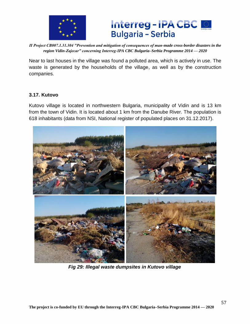
П Project CB007.1.31.304 "Prevention and mitigation of consequences of man-made cross-border disasters in the
region Vidin-Zajecar” concerning Interreg-IPA CBC Bulgaria–Serbia Programme 2014 — 2020
The project is co-funded by EU through the Interreg-IPA CBC Bulgaria–Serbia Programme 2014 — 2020 57
Near to last houses in the village was found a polluted area, which is actively in use. The
waste is generated by the households of the village, as well as by the construction
companies.
3.17. Kutovo
Kutovo village is located in northwestern Bulgaria, municipality of Vidin and is 13 km
from the town of Vidin. It is located about 1 km from the Danube River. The population is
618 inhabitants (data from NSI, National register of populated places on 31.12.2017).
Fig 29: Illegal waste dumpsites in Kutovo village

П Project CB007.1.31.304 "Prevention and mitigation of consequences of man-made cross-border disasters in the
region Vidin-Zajecar” concerning Interreg-IPA CBC Bulgaria–Serbia Programme 2014 — 2020
The project is co-funded by EU through the Interreg-IPA CBC Bulgaria–Serbia Programme 2014 — 2020 58
A large amount of waste can be observed in the area “Valya Porchilor”-- very close to
the Danube River, on the river dike. The area “Choara” is in a former irrigation channel.
There is high risk here.
3.18. Novoseltsi
Novoseltsi village is located in northwestern Bulgaria, municipality of Vidin.
It is situated 6.12 km. west of Vidin. Neighboring places of village of Novoseltsi are
villages Slana Bara, Ruptsi and the town of Vidin. The village is crossed by main road 14
Vidin-Kula. Near the village passes the Topolovets River, and the Danube River is 7 km
away. The population is 808 inhabitants (data from NSI, National register of populated
places on 31.12.2017).
Fig 30: Illegal waste dumpsites in Novoseltsi village

П Project CB007.1.31.304 "Prevention and mitigation of consequences of man-made cross-border disasters in the
region Vidin-Zajecar” concerning Interreg-IPA CBC Bulgaria–Serbia Programme 2014 — 2020
The project is co-funded by EU through the Interreg-IPA CBC Bulgaria–Serbia Programme 2014 — 2020 59
At the end of 8th and 14th streets a contaminated area can be observed. Plant, plastic and food waste dominate. Because of the very narrow streets between houses built randomly without any planning, waste collection is not possible. Some hazardous waste was found.
3.19. Pokrayna
Pokrayna village is located in northwestern Bulgaria, municipality of Vidin, and is located 3 km north of the city of Vidin. Because of the proximity to the district town the village is one of the largest in the area. It is situated under the great bend of the Danube River, surrounded on three sides by the river -- north, east and south. It is located in the riparian plain on a flat field without any hills.
Fig 31: Illegal waste dumpsites in Pokrayna village
Between the village of Pokrayna and Vidin there is the terminal of the Vidin-Calafat ferry,
the starting point of the Republican Road I-1 and the Bulgarian section of the European
road E79, as well as the approaches to Vidin-Kalafat Bridge, also known as the New
Europe Bridge. Nearby are the Vidin border checkpoint, customs, and the duty-free
zone, one of the main bases of the transport company SOMAT. The population is 1,062
inhabitants (data from NSI, National register of populated places on 31.12.2017).
The waste is generated by travelers. A second polluted site is located next to the farm
yard on the Gomotartsi Road.

П Project CB007.1.31.304 "Prevention and mitigation of consequences of man-made cross-border disasters in the
region Vidin-Zajecar” concerning Interreg-IPA CBC Bulgaria–Serbia Programme 2014 — 2020
The project is co-funded by EU through the Interreg-IPA CBC Bulgaria–Serbia Programme 2014 — 2020 60
3.20. Ruptsi
Ruptsi village is located in northwestern Bulgaria, municipality of Vidin.
It is situated 6.85 km. west of Vidin. Neighboring villages are Akatsievo, General
Marinovo and the town of Vidin. The River Topolovets is 1 km away and the Danube
River is 6 km away. The population is 117 inhabitants (data from NSI, National register
of populated places on 31.12.2017).
Fig 32: Illegal waste dumpsites in Ruptsi village
Waste is generated by the local population. Inert and plant wastes dominate and there is
risk for agricultural land.
3.21. Sinagovtsi
Sinagovtsi village is located in northwestern Bulgaria, municipality of Vidin.
It is situated 20 km. south of Vidin. Neighboring villages are Tarnyane and Ivanovtsi and
the city of Dunavtsi. Three km from the village crosses the main road E79 Vidin-
Montana. Near the village Sinagovtsi runs the Vidbol River and the Danube is situated 6
km. away. The population is 354 inhabitants (data from NSI, National register of
populated places on 31.12.2017).

П Project CB007.1.31.304 "Prevention and mitigation of consequences of man-made cross-border disasters in the
region Vidin-Zajecar” concerning Interreg-IPA CBC Bulgaria–Serbia Programme 2014 — 2020
The project is co-funded by EU through the Interreg-IPA CBC Bulgaria–Serbia Programme 2014 — 2020 61
Fig 33: Illegal waste dumpsites in Sinagotsi village
Polluted territory is a registration in the former depot. It is periodically sprinkled, 1-2
times a year. The risks are mainly to agricultural land.
3.22. Slana Bara
Slana Bara village is located in northwestern Bulgaria, municipality of Vidin.
The village is 6km southwest of Vidin. The population is 344 inhabitants (data from NSI,
National register of populated places on 31.12.2017).

П Project CB007.1.31.304 "Prevention and mitigation of consequences of man-made cross-border disasters in the
region Vidin-Zajecar” concerning Interreg-IPA CBC Bulgaria–Serbia Programme 2014 — 2020
The project is co-funded by EU through the Interreg-IPA CBC Bulgaria–Serbia Programme 2014 — 2020 62
Fig 34: Illegal waste dumpsites in Slana Bara village
At this dumpsite inert, garden and plastic waste dominate.
3.23. Slanotran
Slanotran village is located in northwestern Bulgaria, municipality of Vidin, 18 km from
the city of Vidin. The population is 445 inhabitants (data from NSI, National register of
populated places on 31.12.2017).

П Project CB007.1.31.304 "Prevention and mitigation of consequences of man-made cross-border disasters in the
region Vidin-Zajecar” concerning Interreg-IPA CBC Bulgaria–Serbia Programme 2014 — 2020
The project is co-funded by EU through the Interreg-IPA CBC Bulgaria–Serbia Programme 2014 — 2020 63
Fig 35: Illegal waste dumpsites in Slanotran village
A small amount of waste, generated by the population of the village, was observed.
3.24. Tsar Simeonovo
Tsar Simeonovo village is located in northwestern Bulgaria, municipality of Vidin. It is
situated on the bank of the Danube River, 22.56 km. south of the town of Vidin.
Neighboring villages are Botevo, Gaytantsi and the town of Dunavtsi. Through the
village passes main road No 11 Vidin - Lom. The population is 111 inhabitants (data
from NSI, National register of populated places on 31.12.2017).
Fig 36: Illegal waste dumpsites in Tsar Simeonovo village

П Project CB007.1.31.304 "Prevention and mitigation of consequences of man-made cross-border disasters in the
region Vidin-Zajecar” concerning Interreg-IPA CBC Bulgaria–Serbia Programme 2014 — 2020
The project is co-funded by EU through the Interreg-IPA CBC Bulgaria–Serbia Programme 2014 — 2020 64
Inert waste dominates.
4. Waste-related disaster risks in the Bulgaria-Serbian cross-border area
The Energy Agency of Plovdiv has analysed the floods of 2013-2014 on the territory of
Bulgaria and Serbia.
4.1. Floods in 2013
Extreme floods occurred in June 2013 on the upper and lower Danube, and the strength
and intensity of this flood event reminded observers of floods in 2002. The flood impact
was devastating in Germany, Austria, Slovakia, Romania and Hungary, and remarkable
consequences were observed in Bulgaria, Croatia and Serbia.
Also in Bulgaria the total rainfall in June was about 40% above the long-term monthly
average. The most intensive rainfall was registered during 30.06–01.07 in the Silistra-
region (64 to 140 mm), in the Ruse-region (127 mm) and in the Tutrakan region (110
mm).
Interventions were undertaken in the regions affected by flash floods. Emergency teams
from the Main Directorate Fire Safety and Protection of the Population at the Ministry of
Interior were activated to carry out the rescue operations and to drain the flooded
residential areas.
Residential areas in the Sofia region and Lovech were flooded due to the heavy rainfall
on 11th and 25th June. Torrential rainfall between 30th June and 1st July caused
flooding and damages to properties in the residential areas of Silistra, Dobrich and
Russe municipalities in the northeastern part of the country. The most affected area was
the municipality of Glavinitsa and Valchi Dol, where many streets, private properties and
public buildings were flooded and damaged. There were isolated cases of evacuation of
people from flooded buildings and cars. Besides the emergency interventions,
disinfection work was carried out in some flooded settlements in order to avoid further
adverse consequences related to the environment and human health.
The damages include flooded and damaged private and public buildings, roads and
streets. Due to a landslide a local road was closed. The regional library in Ruse was

П Project CB007.1.31.304 "Prevention and mitigation of consequences of man-made cross-border disasters in the
region Vidin-Zajecar” concerning Interreg-IPA CBC Bulgaria–Serbia Programme 2014 — 2020
The project is co-funded by EU through the Interreg-IPA CBC Bulgaria–Serbia Programme 2014 — 2020 65
flooded, and about 50,000 books had to be evacuated; 108 households were affected
after the flooding in the Glavinitsa Municipality. Four houses were assessed as being in
danger of collapse and some others as needing fortifications. A drainage channel spilt
over; agriculture areas were inundated and crops were destroyed. The total damage in
Glavinitsa is being assessed at over 300,000 €. All the streets in the Municipality of
Valchi Dol were flooded and many of them have been damaged. Almost all residential
buildings have been affected. Many public buildings, including three schools and the
Municipality’s cultural club, were damaged. Sewage has been blocked up by silt.
4.2. Floods in 2014
During the third week of May, exceptionally heavy rains fell on Serbia, which was
caused by a low-pressure system (‘Yvette’) that formed over the Adriatic. Record-
breaking amounts of rainfall exceeding 200 mm fell in western Serbia in a week’s time,
which is the equivalent of three months of rain under normal conditions.
The heavy rainfalls led to a rapid and substantial increase in water levels in the main
rivers in western, southwestern, central and eastern Serbia: Sava, Tamnava, Kolubara,
Jadar, Zapadna Morava, Velika Morava, Mlava and Pek. In the Sava River basins where
most of the rainfall was received, the consequences were two-fold. In the first place,
flash floods occurred in the tributaries where water levels rose almost immediately after
the onset of the rains and then dropped quickly back to normal levels when the rains
stopped. In this regard, the water level at Beli Brod on the tributary river Kolubara rose
by 7 meters on 14-16 May but was back to normal levels by 18-19 May. The second
consequence was that the level of the River Sava itself rose at a more gradual rate, with
an increase of 3.5 meters recorded over the period 14-20 May. In contrast to its
tributaries, the water level on the Sava peaked after the rains had stopped and
decreased much more slowly after the peak (by some 20- 30 centimetres per day). This
delay in response time is due to the travelling time of the water through the entire river
catchment, including the upstream reaches of the Sava.
The heavy rainfall and rising water levels had three immediate and direct effects:
High-intensity flash floods resulting in the total destruction of houses, bridges and
sections of roads (in Krupanj and areas around Sabac);

П Project CB007.1.31.304 "Prevention and mitigation of consequences of man-made cross-border disasters in the
region Vidin-Zajecar” concerning Interreg-IPA CBC Bulgaria–Serbia Programme 2014 — 2020
The project is co-funded by EU through the Interreg-IPA CBC Bulgaria–Serbia Programme 2014 — 2020 66
Rising water levels resulting in the widespread flooding of both urban areas
(particularly in Obrenovac) and rural areas (around Sabac); and,
Increased flow of underground waters leading to widespread landslides (around
Krupanj and Bajina Basta).
Overall, the floods affected some 1.6 million people living in 38 municipalities/cities
mostly located in central and western Serbia. Two cities (Šabac and Sremska Mitrovica)
and 17 municipalities (Obrenovac, Mali Zvornik, Krupanj, Ljubovija, Vladimirci,
Koceljeva, Šid, Svilajnac, Paraćin, Ub, Lajkovac, Ljig, Osečina, Mionica, Smederevska
Palanka, Trstenik, Bajina Bašta) were severely impacted.
Torrential rainfall in Bulgaria caused unprecedented flooding across the country, killing
at least 11 people, with several others missing. The worst of the floods struck late on
Thursday, June,19 2014, although Bulgaria’s Black Sea coast had seen some minor
flooding a few days earlier.
The victims of the flood in Varna were 13. Three died in Dobrich, where as many as 150
people had to be evacuated.
Along the Black Sea Coast the worst-hit areas are Varna and Burgas, two of the more
densely populated communities in the region. Weather experts claim that the equivalent
of a month’s amount of rain fell in just 24 hours. Further rainfall had been forecast for
northern and eastern Bulgaria for the following 24 hours.
The flooding destroyed houses and roads in particular in the Asparuhouvo area of
Varna. Some reports claim that cars were floating along streets and in some cases piled
on top of each other. Floodwater was over one meter deep in some areas. Storms and
strong winds also led to power outages. Regional Police say that several bodies were
found near Varna after they had been swept away by floodwater.
In Kilifarevo, in central Bulgaria, around 11 people had to be rescued from the roofs of
houses after they took refuge from the floodwater. Other areas near the capital Sofia
were affected, including Chavdar, where over 100 homes were damaged by floods.
The Bulgarian National statistical institute provides information about the number of
floods in Bulgaria for the period 2010-2017:

П Project CB007.1.31.304 "Prevention and mitigation of consequences of man-made cross-border disasters in the region Vidin-Zajecar” concerning
Interreg-IPA CBC Bulgaria–Serbia Programme 2014 — 2020
The project is co-funded by EU through the Interreg-IPA CBC Bulgaria–Serbia Programme 2014 — 2020 67
Table XIII: Data from NSI by year for the floods in Bulgaria and costs of the damages:
Regions Numbers Determinate damages – thousands BGN
2010 2011 2012 2013 2014 2015 2016 2017* 2010 2011 2012 2013 2014 2015 2016 2017*
Total 651 382 692 547 360 266 184 159 38882 206659 20898 15285 177604 171032 30617 135530
Blagoevgrad 14 10 5 14 4 3 5 1 12094 1061 61 119 639 384 75 -
Burgas 82 22 77 37 19 14 42 55 493 140 384 13 16205 136129 807 117959
Varna 30 16 11 15 28 47 4 2 2615 1315 1226 1369 37797 3548 4664 669
Велико Търново 24 28 32 17 21 3 1 1 224 305 1829 789 23834 2061 131 3211
Vidin 1 1 4 - 2 - - - - 133 250 - 493 - - -
Vraca - 10 5 1 5 5 1 - - 230 - 4 25810 635 - -
Gabrovo 8 9 7 2 13 - 2 - 139 78 606 84 6825 - 2792 -
Dobrich 10 21 3 2 4 2 2 1 405 499 1 216 7854 1951 34 800
Kardjali 11 12 19 9 14 13 26 16 164 224 1175 1131 976 2418 5436 4230
Kustendil 2 5 11 1 1 17 1 14 2249 435 452 301 - 1016 11 677
Lovech 4 1 1 - 3 - - - 460 4 4 - 165 - - -
Montana 14 11 6 4 30 2 2 5 551 500 342 13 11123 19 - 5
Parzrdjik 27 11 2 4 7 2 - 1 968 353 - 23 1007 - - 1000
Pernik 9 13 2 1 1 4 1 2 892 22 2 13 9 1 2 75
Pleven 14 10 1 - 19 31 3 4 1099 792 18 - 1384 2592 12 1440
Plovdiv 9 - 2 2 42 7 2 18 4446 - 152 195 17563 1416 8301 2803
Razgrad 1 - 2 8 5 - 2 - 26 - 42 1528 307 - 1 -
Ruse 6 5 5 2 11 23 14 4 255 868 135 162 1330 4152 2852 631
Silistra - 4 - 1 2 - - - - 418 - 2536 - - - -
Sliven 102 51 267 335 25 36 39 21 1227 719 - - 62 1335 176 35
Smolyan 179 97 98 88 43 29 30 9 8092 8113 8030 6327 3406 9248 5154 1069
Sofia 30 32 8 2 25 7 3 4 454 190006 800 409 5738 740 - 345
Stara Zagora 7 5 115 - 8 11 - - 258 - 842 - 7654 1686 - -
Hsakovo 3 6 5 1 10 7 4 - 273 432 4325 - 4240 225 169 -
Shumen 1 1 4 1 16 3 - - 11 10 222 53 2905 1476 - -

П Project CB007.1.31.304 "Prevention and mitigation of consequences of man-made cross-border disasters in the
region Vidin-Zajecar” concerning Interreg-IPA CBC Bulgaria–Serbia Programme 2014 — 2020
The project is co-funded by EU through the Interreg-IPA CBC Bulgaria–Serbia Programme 2014 — 2020 68
From the analysis of contaminated sites management data, it can be concluded
that preliminary studies of all identified potentially contaminated sites up to 2012
have been carried out, while main site investigations have been completed on a
lesser number of sites (Tab. 1). Data sources on progress in the management of local
soil pollution are represented by research and monitoring projects on soil and
groundwater pollution from localized sources. These data are then used as input to
the database managed by the Environmental Protection Agency.
The results allow an assessment of which are the most dominant sources of local soil
contamination.
The biggest number of registered sources of localized soil pollution are related to
municipal waste disposal sites (39.9%), oil extraction and production (28%) and
industrial and commercial activities (10.8%). The database of potentially polluted and
polluted sites does not include military sites. The number of sites in which manure is
being stored is not reliable and for that reason is not reported.

П Project CB007.1.31.304 "Prevention and mitigation of consequences of man-made cross-border disasters in the
region Vidin-Zajecar” concerning Interreg-IPA CBC Bulgaria–Serbia Programme 2014 — 2020
The project is co-funded by EU through the Interreg-IPA CBC Bulgaria–Serbia Programme 2014 — 2020 69
Fig 37: Localized soil pollution sites in Serbia

П Project CB007.1.31.304 "Prevention and mitigation of consequences of man-made cross-border disasters in the
region Vidin-Zajecar” concerning Interreg-IPA CBC Bulgaria–Serbia Programme 2014 — 2020
The project is co-funded by EU through the Interreg-IPA CBC Bulgaria–Serbia Programme 2014 — 2020 70
Fig 38: Breakdown of activities causing local soil contamination [%]
4.3. Conclusions
Most of the trans - border region is located in remote areas outside of dynamic
economic centers and, with the exception of Sofia, far away from big cities. A big area of
the border region could be categorized as an economically underdeveloped rural area. A
common characteristic of the Bulgarian and Serbian border regions is their low
economic development compared to the remaining territories of both countries (IPA,
2007).
Border regions often have lower population density than the national average because
central places or big cities are usually not located in border areas. In the Bulgarian
border region, too, the population density is 1.5 times lower than the national average; in
Serbia it is 1.3 times lower.
Illegal dumpsites are formed near populated areas. That means that environmental risks
and exposure risk in the cross-border region are very low.

П Project CB007.1.31.304 "Prevention and mitigation of consequences of man-made cross-border disasters in the
region Vidin-Zajecar” concerning Interreg-IPA CBC Bulgaria–Serbia Programme 2014 — 2020
The project is co-funded by EU through the Interreg-IPA CBC Bulgaria–Serbia Programme 2014 — 2020 71
The data on floods in the period 2012- 2015 show that floods were mainly due to heavy
rainfalls and not from human activities.
5. Environmental effects on the CBC area from the illegal dumps on the territory of the municipality of Vidin
During the visits to the dumpsites the experts from the Energy Agency of Plovdiv
evaluated the environmental effects due to the waste dumping. The analysis covered
the environmental impacts of illegal waste disposal on land deterioration, on ground
and surface water, and on air quality. Waste composition such as types of substances -
- particularly toxic waste coming from the last phase of the industrial activities: copper,
arsenic, mercury, polychlorinated biphenyls, hydrocarbons, etc. -- will be studied.
Waste disposal practices including illegal burying in areas not legally designated as
toxic waste dumpsites such as cultivable areas, roads and buildings and construction
yards, their impact on land, water and air pollution, were analysed. The effect of the
chemicals and non-biodegradable materials in the contaminated groundwater and soil
on the physical environment and the waterways, agriculture and wildlife were studied,
together with the effect on domesticated animals after consuming poisonous materials
such as plastics and chemicals from the waste. Risks of other practices such as illegal
dumping of chemicals, tires, green waste and cigarette butts will be also assessed. The
analyses will cover the following impacts:
5.1. Air quality
Many household appliances and other waste could contain harmful chemicals which can
be extremely damaging when released. For example, refrigerators and freezers contain
either tetrafluoroethane or chloro-fluoro-carbon, both of which destroy the earth's ozone
layer. The analyses show that inert materials predominate next to the garden and plastic
waste. This kind of appliances was not found in the contaminated areas and air quality is
not affected in this way. Inert materials are a source of particulate matter.

П Project CB007.1.31.304 "Prevention and mitigation of consequences of man-made cross-border disasters in the
region Vidin-Zajecar” concerning Interreg-IPA CBC Bulgaria–Serbia Programme 2014 — 2020
The project is co-funded by EU through the Interreg-IPA CBC Bulgaria–Serbia Programme 2014 — 2020 72
5.2. Surface and ground waters
Illegal dumping near waterways can cause river pollution. In rural or remote areas in
poorer countries, rubbish disposal facilities are often completely absent. This leaves two
ways of disposing of trash: dumping it into the environment or burning it. Unfortunately,
the most common disposal method involves throwing the garbage directly into a river or
stream, as the case in Kutovo village. The contaminated area “Valya Porchilor” is very
close to the Danube River--in fact, on the river dike.
5.3. Soils
The possibility of soil contamination by different hazardous wastes has been evaluated.
The possible contaminants come from illegal deposition of different chemical
compositions used in agriculture. In some cases the contaminated areas cover the
agricultural land. The villages at risk are Gomotartsi, Zheglitsa, Kutovo, Novoseltsi,
Ruptsi and Sinagovtsi.
5.4. Plants and wildlife
Illegal dumping can adversely affect many native species of plants and animals. If
animals consume waste from illegal dump sites it can cause health complications and
even death. The toxins from waste can leach into the surrounding environment, killing
plants and destroying the food sources of local animals. The possible contaminants
come from illegal deposition of chemical compositions used in agriculture. The risk is to
the plants. The villages at risk are Gomotartsi, Zheglitsa, Kutovo, Novoseltsi, Ruptsi
and Sinagovtsi
5.5. Aesthetic impact
Illegally dumped garbage can be a horrible eyesore in an otherwise beautiful place. This
can reduce tourism and therefore reduce community revenue, which in turn reduces the
funds available to deal with the problem. The contaminated areas are in small villages
with small of populations. Demographic and economic impacts dominate. The

П Project CB007.1.31.304 "Prevention and mitigation of consequences of man-made cross-border disasters in the
region Vidin-Zajecar” concerning Interreg-IPA CBC Bulgaria–Serbia Programme 2014 — 2020
The project is co-funded by EU through the Interreg-IPA CBC Bulgaria–Serbia Programme 2014 — 2020 73
contaminated areas are outside of the villages and are not an aesthetic problem.
Tourism is not developed.
Plastic bags (part of plastic waste) were blown long distances by the wind and ruin the
landscape.
5.6. Fires
They can occur from either spontaneous combustion or arson. This can be hazardous,
as the sites may have old aerosol or gas cans that can lead to explosions, and
household or farm chemicals can give off toxic smoke. Burning at these sites can lead to
forest fires and erosion, and sediment loading can occur in streams. This can also cause
damage to and evacuation of surrounding neighborhoods.
The impact of the risks was evaluated during the visits to the contaminated areas, based
on a three levels risk: 1- low, 2- medium, 3- high. They are summarized in the table
below:
Table XIV Risk impact
Settlement Area Air Ground water
Under ground water
Plant and
wildlife
Floods Fire
Akatsievo area “Baira” / Border between Akatsievo and
Ruptsi - channel /
1
Antimovo In the area of Cemetery Park
2 2 3 2 2 3
Bela Rada area “Tarneto” 2
Botevo area “Gaydarski dol” / Vegetable gardens near
Danube River /
1
Bukovets area “Vishite” 1 1
area “Gradinite” 2 2 2
former canton 1 1
former cooperative farms 2 2
Gaytantsi On the way to the village of Archar
1 1 1 1
Former cooperative farms

П Project CB007.1.31.304 "Prevention and mitigation of consequences of man-made cross-border disasters in the
region Vidin-Zajecar” concerning Interreg-IPA CBC Bulgaria–Serbia Programme 2014 — 2020
The project is co-funded by EU through the Interreg-IPA CBC Bulgaria–Serbia Programme 2014 — 2020 74
Settlement Area Air Ground water
Under ground water
Plant and
wildlife
Floods Fire
Gomotartsi area “Valya Ra” / Near the Pump Station /
2 2 3 3 3 3
end of 12-th str 2 2 2 2 2 3
end of 28-th str and 1-st str
1 1 2 2 2 3
end of 34-th str 1 1 1 1 1 1
end of 10-th str 1
Gradetс area “Drakata” 2 1 1 1
area “Grachko bardo” 2 1 1 1
area “Royaka” 1 1
area “Do selo” 1 1 1 1
Dinkovitsa end of 9-th str
Dunavtsi behind railway station 1
former pigs farm 2
Zheglitsa A former agricultural airport
2 1 1 2 1 3
Ivanovtsi Аrеа “Selsko” /former soccer field/
2 1
Inovo the old semetеry 1
area “Lozyata” 2 1 2 2 2 3
Kalenik end of 3-rd str 1 1 1
near to the village stadium
1 2
near to the semetery 1
Kapitanovtsi Drenage on the road to Inovo village
1 1 1 2 1 1
to the west of Kapitanovtsi village to Negovanovtsi village
2 2 2 2 2 3
Koshava №7 20-th street 3 2 2 3 2 3
Kutovo area “Valya Porchilor” 2 2 3 2 2 2
area “Choara” 2 2 3 2 2 2
Novoseltsi 8-th str 1 1 1 2 1 2
14-th str 1 1 1 1
Pokrayna near to farmyard on the road to Gomotartsi
village
1 1 1 2 1 2
Ruptsi on the road to Akatsievo village
1 1 1 1

П Project CB007.1.31.304 "Prevention and mitigation of consequences of man-made cross-border disasters in the
region Vidin-Zajecar” concerning Interreg-IPA CBC Bulgaria–Serbia Programme 2014 — 2020
The project is co-funded by EU through the Interreg-IPA CBC Bulgaria–Serbia Programme 2014 — 2020 75
Settlement Area Air Ground water
Under ground water
Plant and
wildlife
Floods Fire
Sinagovtsi district “Mihalaki Georgievo”
former landfild 2 2 2 1 3
Slana bara On the road to Bukovets village
2 1
Slanotran on the road to former mineral bath
1 1 1
on the road to former canton
1 1
Tsar Simeonovo
former farmyard/ on the road to Botevo village/
1 2
The village with the highest risk is Koshava; immediate clearing action is required. The other areas for fast reaction are Kutovo and Sinagovtsi.
6. Health effects on the CBC area from the illegal dumps on the territory of the municipality of Vidin
The health impact was evaluated during the visits to the contaminated areas, based on
a three levels risk: 1- low, 2- medium, 3- high. They are summarized in the table below:
Table XV Health assessment of contaminated areas
Settlement Population Number of illegal
dumpsites
Area Health
Akatsievo 59 1 area “Baira” / Border between Akatsievo and Ruptsi - channel /
Antimovo 436 1 In the area of Cemetery Park 2
Bela Rada 431 1 area “Tarneto”
Botevo 49 1 area “Gaydarski dol” / Vegetable gardens near Danube River /
Bukovets
565
4
area “Vishite”
area “Gradinite” 3
former canton
former cooperative farms 1
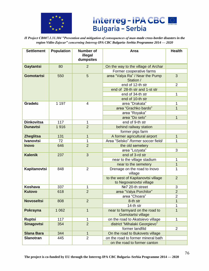
П Project CB007.1.31.304 "Prevention and mitigation of consequences of man-made cross-border disasters in the
region Vidin-Zajecar” concerning Interreg-IPA CBC Bulgaria–Serbia Programme 2014 — 2020
The project is co-funded by EU through the Interreg-IPA CBC Bulgaria–Serbia Programme 2014 — 2020 76
Settlement Population Number of illegal
dumpsites
Area Health
Gaytantsi
80
2
On the way to the village of Archar
Former cooperative farms
Gomotartsi
550
5
area “Valya Ra” / Near the Pump Station /
3
end of 12-th str 2
end of 28-th str and 1-st str
end of 34-th str 1
end of 10-th str
Gradetс
1 197
4
area “Drakata” 1
area “Grachko bardo” 1
area “Royaka”
area “Do selo” 1
Dinkovitsa 117 1 end of 9-th str
Dunavtsi
1 916
2
behind railway station
former pigs farm
Zheglitsa 131 1 A former agricultural airport 1
Ivanovtsi 72 1 Area “Selsko” /former soccer field/ 1
Inovo
646
2
the old semetеry
area “Lozyata” 3
Kalenik
237
3
end of 3-rd str
near to the village stadium 1
near to the semetery 1
Kapitanovtsi
848
2
Drenage on the road to Inovo village
1
to the west of Kapitanovtsi village to Negovanovtsi village
2
Koshava 337 1 №7 20-th street 3
Kutovo
618
2
area “Valya Porchilor” 2
area “Choara” 2
Novoseltsi
808
2
8-th str 1
14-th str 1
Pokrayna
1 062 1 near to farmyard on the road to Gomotartsi village
1
Ruptsi 117 1 on the road to Akatsievo village 1
Sinagovtsi
354
2
district “Mihalaki Georgievo”
former landfild 2
Slana Bara 344 1 On the road to Bukovets village
Slanotran
445
2
on the road to former mineral bath
on the road to former canton

П Project CB007.1.31.304 "Prevention and mitigation of consequences of man-made cross-border disasters in the
region Vidin-Zajecar” concerning Interreg-IPA CBC Bulgaria–Serbia Programme 2014 — 2020
The project is co-funded by EU through the Interreg-IPA CBC Bulgaria–Serbia Programme 2014 — 2020 77
Settlement Population Number of illegal
dumpsites
Area Health
Tsar Simeonovo
111 1 former farmyard/ on the road to Botevo village/
2
The highest risks are contaminated areas with hazardous waste. The villages in risk are: Gomotartsi, Inovo and Koshava.
7. Economic effects on the CBC area from the illegal dumps on the
territory of the municipality of Vidin
The Waste Management Act in Bulgaria (Promulgated, State Gazette No.
53/13.07.2012, effective 13.07.2012, amended, SG No. 66/26.07.2013, effective
26.07.2013; Judgment No. 11/10.07.2014 of the Constitutional Court of the Republic of
Bulgaria - SG No. 61/25.07.2014; amended, SG No. 98/28.11.2014, effective
28.11.2014, SG No. 14/20.02.2015, amended and supplemented, SG No.
105/30.12.2016, SG No. 13/7.02.2017) determines:
Article 54 (Amended, SG No. 105/2016) The expenses for waste management shall be
covered by:
1. the original waste producer or the current or previous waste holder; 2. persons placing on the market products which, after use, form ordinary waste, in the cases referred to in this Act.
Article 55 (1) Where the producers or waste are unidentified, the costs of environmental remediation shall be borne by the persons who or which are in holding of any such waste. (2) All costs of environmental remediation and of identification of the actual producer of the waste shall be recovered therefrom. Article 154. When the producers of waste referred to in Article 55, paragraph 1 are
identified, natural persons are sanctioned with a fine of BGN 3,000 or exceeding this

П Project CB007.1.31.304 "Prevention and mitigation of consequences of man-made cross-border disasters in the
region Vidin-Zajecar” concerning Interreg-IPA CBC Bulgaria–Serbia Programme 2014 — 2020
The project is co-funded by EU through the Interreg-IPA CBC Bulgaria–Serbia Programme 2014 — 2020 78
amount but not exceeding BGN 10,000, and legal persons and sole traders are
sanctioned with a pecuniary penalty of BGN 6,000 or exceeding this amount but not
exceeding BGN 20,000.
The municipalities could ask for financing from the Ministry of Environment and Water:
Article 56. (1) On a motion by the Minister of Environment and Water, resources shall
be allocated annually by the State Budget of the Republic of Bulgaria Act for the specific
purpose of construction of facilities and installations for treatment of household, ordinary
and hazardous waste, as well as for cleaning and reclamation of places polluted with
waste.
Article 57. The expenses for operations with household waste and compliance with the
obligations of the local self-government authorities and the local administration referred
to in Chapter Two, Section III of this Act shall be planned in the budget of the relevant
municipality in an amount at least equal to the revenues from local fees pursuant to
Article 6, paragraph 1(a) of the Local Taxes and Fees Act planned for the respective
year.
In general, the cleaning of the contaminated areas consists of collecting, loading and
transporting the waste to a landfill or at a site (by sinking and sprinkling) and includes
the following types of activities:
- Collection of waste
In most cases, waste is dumped into separate piles and it is necessary to collect it with
appropriate equipment. In other cases, the waste is accumulated and sealed into a
layer. In a relatively some cases, manual waste collection is required - when they are
from light fractions scattered over a large area or due to the specificity of the relief.
In case the pollution is from biodegradable or inert waste and the site allows it, it is
possible to clean it on site. The necessary activities are collecting the waste, forming a
pile, compacting and eventually spraying.
- Loading of waste
The load is mainly carried by the loader equipment, but in some cases it may be
necessary to load manually.
- Transport of the waste to the municipal landfill.

П Project CB007.1.31.304 "Prevention and mitigation of consequences of man-made cross-border disasters in the
region Vidin-Zajecar” concerning Interreg-IPA CBC Bulgaria–Serbia Programme 2014 — 2020
The project is co-funded by EU through the Interreg-IPA CBC Bulgaria–Serbia Programme 2014 — 2020 79
A market study and analyses for the clean-up activities has been carried out. The final
costs are formed by calculation of the costs for collection, loading and transport to the
municipal landfill as an average price.
Table XVI: Economic assessment- necessary financing for cleaning up activities
№ Settlement № of illegal dumps
Distance to the municipal landfill
Waste (in m³)
Lv,without VAT
Lv with VAT
1 Akatsievo 1 21 20 273 328
2 Antimovo 1 26 20 338 406
3 Bela Rada 1 22 30 429 515
4 Botevo 1 7 20 91 109
5 Bukovets 4 24 600 9 360 11 232
6 Gaytantsi 2 22 15 215 257
7 Gomotartsi 5 36 1 030 24 102 28 922
8 Gradetс 4 34 260 5 746 6 895
9 Dinkovitsa 1 26 50 845 1 014
10 Dunavtsi 2 7 40 182 218
11 Zheglitsa 1 2 1 580 2 054 2 465
12 Ivanovtsi 1 11 20 143 172
13 Inovo 2 22 315 4 505 5 405
14 Kalenik 3 33 75 1 609 1 931
15 Kapitanovtsi 2 23 5 020 75 049 90 059
16 Koshava 1 36 1 000 23 400 28 080
17 Kutovo 2 29 4 000 75 400 90 480
18 Novoseltsi 2 18 100 1 170 1 404
19 Pokrayna 1 23 20 299 359
20 Ruptsi 1 19 30 371 445
21 Sinagovtsi 1 8 3 000 15 600 18 720
22 Slana bara 1 17 15 166 199
23 Slanotran 2 34 45 995 1 193
24 Tsar Simeonovo 1 5 18 59 70
505 17 323
Total 242 398 290 878

П Project CB007.1.31.304 "Prevention and mitigation of consequences of man-made cross-border disasters in the
region Vidin-Zajecar” concerning Interreg-IPA CBC Bulgaria–Serbia Programme 2014 — 2020
The project is co-funded by EU through the Interreg-IPA CBC Bulgaria–Serbia Programme 2014 — 2020 80
8. Map of the illegal dumpsites on the territory of the municipality of Vidin
A map of illegal dumps on the territory of the municipality of Vidin and was developed. It
is shown in the Fig. 38
Fig 39: Map of illegal dumpsites
In the table below the polluted areas and their numbers on the map are shown:

П Project CB007.1.31.304 "Prevention and mitigation of consequences of man-made cross-border disasters in the
region Vidin-Zajecar” concerning Interreg-IPA CBC Bulgaria–Serbia Programme 2014 — 2020
The project is co-funded by EU through the Interreg-IPA CBC Bulgaria–Serbia Programme 2014 — 2020 81
Table XVII: Contaminated areas on the territory of municipality Vidin and their
location
№ Settlement Area GPS coordinates
1 Akatsievo area “Baira” / Border between Akatsievo and Ruptsi - channel
44°56'22”/22°48'25”
2 Antimovo In the area of Cemetery Park 44°01'35”/22°57'06”
3 Bela Rada area “Tarneto” 43°58'32”/22°44'58”
4 Botevo area “Gaydarski dol” / Vegetable gardens near Danube River /
43°50'23”/22°51'27”
5 Bukovets area “Vishite” 43°56'07”/22°46'37”
area “Gradinite” 43°56'07”/22°46'37”
former canton 43°55'33”/22°45'17”
former cooperative farms 43°55'39”/22°45'16”
6 Gaytantsi On the way to the village of Archar 43°49'49”/22°49'06”
Former cooperative farms 43°49'48”/22°48'46”
7 Gomotartsi area “Valya Ra” / Near the Pump Station /
44°05'36”/22°56'35”
end of 12-th str 44°05'10”/22°58'09”
end of 28-th str and 1-st str 44°05'11”/22°57'46”
end of 34-th str 44°05'06”/22°57'44”
end of 10-th str 44°05'12”/22°57'44”
8 Gradetс area “Drakata” 44°02'06”/22°43'46”
area “Grachko bardo” 44°02'08”/22°44'39”
area “Royaka” 44°01'46”/22°45'54”
area “Do selo” 44°01'45”/22°45'54”
9 Dinkovitsa end of 9-th str 44°02'25”/22°46'31”
10 Dunavtsi behind railway station 43°54'37”/22°49'11”
former pigs farm 43°55'36”/22°49'28”
11 Zheglitsa A former agricultural airport 43°52'55”/22°47'42”
12 Ivanovtsi Аrеа “Selsko” /former soccer field/ 43°51'39”/22°45'31”
13 Inovo the old semetеry 44°01'44”/22°50'06”
area “Lozyata” 44°01'51”/22°50'30”
14 Kalenik end of 3-rd str 44°00'26”/22°39'46”
near to the village stadium 44°00'12”/22°39'39”
near to the semetery 44°00'06”/22°39'47”
15 Kapitanovtsi Drenage on the road to Inovo village 44°02'30”/22°51'59”
to the west of Kapitanovtsi village to 44°02'34”/22°52'35”

П Project CB007.1.31.304 "Prevention and mitigation of consequences of man-made cross-border disasters in the
region Vidin-Zajecar” concerning Interreg-IPA CBC Bulgaria–Serbia Programme 2014 — 2020
The project is co-funded by EU through the Interreg-IPA CBC Bulgaria–Serbia Programme 2014 — 2020 82
№ Settlement Area GPS coordinates
Negovanovtsi village
16 Koshava №7 20-th street 44°04'17”/23°01'30”
17 Kutovo area “Valya Porchilor” 44°01'05”/22°58'35”
area “Choara” 44°01'19”/22°57'10”
18 Novoseltsi 8-th str 43°59'07”/22°49'15”
14-th str 43°59'00”/22°49'05”
19 Pokrayna near to farmyard on the road to Gomotartsi village
44°01'39”/22°53'38”
20 Ruptsi on the road to Akatsievo village 44°00'20”/22°48'17”
21 Sinagovtsi former landfild 43°53'51”/22°46'31”
22 Slana bara On the way to Bukovec village 43°57'58”/22°48'24”
23 Slanotran on the road to former mineral bath 44°02'36”/23°01'17”
on the road to former canton 44°02'43”/23°00'11”
24 Tsar Simeonovo
former farmyard/ on the road to Botevo village/
43°50'55”/22°50'35”
9. Recommendations
Taking into account the sizes of the contaminated areas as well as all risks factors
subject to this study, priority should be given to the cleaning up activities for areas of
villages of Kapitanovci, Koshava, Kutovo, Sinagovci and Gomotarci. Following the
economic assessment of the study financing of about 260 000 BGN should be secured
for clearing up the areas in these villages.
Table XVIII: Economic assessment- necessary financing for cleaning up activities
in the priority areas
№ Settlement № of illegal dumps
Distance to the municipal
landfill
Waste (in m³)
lv without VAT
lv, VAT included
7 Gomotartsi 5 36 1 030 24 102 28 922
15 Kapitanovtsi 2 23 5 020 75 049 90 059
16 Koshava 1 36 1 000 23 400 28 080
17 Kutovo 2 29 4 000 75 400 90 480
21 Sinagovtsi 1 8 3 000 15 600 18 720
132 14 050
Total 213 551 256 261

П Project CB007.1.31.304 "Prevention and mitigation of consequences of man-made cross-border disasters in the
region Vidin-Zajecar” concerning Interreg-IPA CBC Bulgaria–Serbia Programme 2014 — 2020
The project is co-funded by EU through the Interreg-IPA CBC Bulgaria–Serbia Programme 2014 — 2020 83
10. Literature
1. Veselaj T. et al, Illegal waste dumps in Kosovo; Green Energy and
Environmental Science in Albania, Agricultural University of Tirana, Albania, 2014
2. Veselaj.T. et al. The environmental impacts of uncontrolled landfill leachate to
the surrounding soil in some regions of Kosovo. The international science
conference” Terra Madre Balkans 2016”, Academy of Sciences in Tirana, 2016,
Albania.
3. Kumar S., J. K. Bhattacharyya, A.N. Vaidya, T. Chakrabarti, , S. Devotta, A.B.
Akolkar, Assessment of the status of municipal solid waste management
in metro cities, state capitals, class I cities, and class II towns in India: An
insight, Waste Management,2009,29, 883–895.
4. MESP, State of waste and chemicals Report, 2014 http://ammk-
rks.net/repository/docs/Raport_ Waste_and_Chemicals_2014.pdf,
5. World Bank, The state environmental analysis, cost assessment of
environmental degradation, institutional review and revision of public spending
on the environment in Kosovo, 2012
6. MESP, Waste management Strategy http://mmph-
rks.org/repository/docs/
7. Maria Triassi et al, Environmental Pollution from Illegal Waste Disposal
andHealth Effects: A Review on the “Triangle of Death”. Int. J. Environ. Res. Public
Health 2015, 12, 1216- 1236; doi:10.3390/ijerph120201216.
8. Dolores Elizabeth Turcott Cervanteset al. Waste Management Program at
the Universidad Tecnologica de Leon. The Open Waste, Management Journal,
2010, 3, 174-183.
9. Report SERBIA FLOODS 2014
http://www.sepa.gov.rs/download/SerbiaRNAreport_2014.pdf
10. 2013 – 2014 floods
(https://www.danubewaterquality.eu/uploads/mod_files/Session_I_Laszlo_Kothay.pdf

П Project CB007.1.31.304 "Prevention and mitigation of consequences of man-made cross-border disasters in the
region Vidin-Zajecar” concerning Interreg-IPA CBC Bulgaria–Serbia Programme 2014 — 2020
The project is co-funded by EU through the Interreg-IPA CBC Bulgaria–Serbia Programme 2014 — 2020 84
11. Floods in June 2013 in the Danube River Basin- International commission for the
protection of the Danube river
(https://www.icpdr.org/main/sites/default/files/nodes/documents/icpdr_floods-
report-web_0.pdf)
12. НАВОДНЕНИЯ ПРЕЗ 2017 ГОДИНА - ОБЩО ЗА СТРАНАТА И ПО ОБЛАСТИ
(http://www.nsi.bg/bg/content/2915/%D0%BD%D0%B0%D0%B2%D0%BE%D0%
B4%D0%BD%D0%B5%D0%BD%D0%B8%D1%8F)
13. Floods in June 2013in the Danube River Basin
https://www.icpdr.org/main/sites/default/files/nodes/documents/icpdr_floods-
report-web_0.pdf
14. INVENTORY OF CONTAMINATED SITES IN SERBIA: http://contaminated-
sites.sazp.sk/sites/contaminated-
sites.sazp.sk/files/prilohy/zbornik%20komplet_opraveny%281%29.pdf
15. The Program for management of municipal waste of the municipality Vidin
11. Annexes
Annex 1- Tool for monitoring, control and reduction of the risk
The tool is excel based, and contains data about the name of settlements with polluted
areas, the number of the dumpsites per settlement, GPS coordinates of the dumpsites,
quantity of waste (in m3 and kg), size of the polluted area (in m2), morphological
analyses for each dumpsite, risk assessment for each dumpsite.

П Project CB007.1.31.304 "Prevention and mitigation of consequences of man-made cross-border disasters in the region Vidin-Zajecar” concerning Interreg-IPA CBC Bulgaria–Serbia Programme 2014 — 2020
The project is co-funded by EU through the Interreg-IPA CBC Bulgaria–Serbia Programme 2014 — 2020 85
№
Settlement
Area
GPS coordinates
Population
№ of illegal dumpsites
Polluted area (in
m²)
Amount of waste (in
m³)
Total polluted area (in
m²)
Total amount of waste (in m³)
Plastic Food Paper and cardboard
Garden/ wood Textile/ tire/
leader Glass Inert Hazardous
Waste weight in the area kg)
Waste
weight in the
settlement (kg)
weight (kg)
Fraction % weight (kg)
Fraction %
weight (kg)
Fraction % weight (kg)
Fraction %
weight (kg)
Fraction %
weight (kg)
Fraction %
weight (kg)
Fraction %
weight (kg)
Fraction, %
1 Akatsievo
area “Baira”/ Border between Akatsievo and Ruptsi - channel
44°56'22”/22°48'25” 59 1 30 20 30 20 20 8%
10 4% 80 33% 5 2% 5 2% 120 50% 2 1% 242 242
2 Antimovo In the area of Cemetery Park
44°01'35”/22°57'06” 436 1 30 20 30 20 15 15% 15 15% 5 5% 15 15% 12 12% 5 5% 30 29% 5 5% 102 102
3 Bela Rada area “Tarneto” 43°58'32”/22°44'58”
1 10 30 10 30 7 5% 5 4% 3 2% 70 52% 5 4%
0% 40 30% 4 3% 134 134
4 Botevo
area “Gaydarski dol”/ Vegetable gardens near Danube River /
43°50'23”/22°51'27” 49 1 20 20 20 20 10 17% 5 9% 5 9% 15 26%
0%
0% 20 34% 3 5% 58 58
5
Bukovets
area “Vishite” 43°56'07”/22°46'37” 565 4 300 50 6 250 600 35 34% 8 8% 5 5% 25 24% 10 10% 3 3% 15 15% 2 2% 103 2 445
area “Gradinite” 43°56'07”/22°46'37”
900 40
20 29% 10 14% 5 7% 15 21% 5 7% 2 3% 10 14% 3 4% 70
former canton 43°55'33”/22°45'17”
50 10
7 11% 5 8% 5 8% 10 16% 15 24%
0% 20 32%
0% 62
former cooperative farms
43°55'39”/22°45'16”
5 000 500
260 12%
0%
0% 250 11% 200 9%
0% 1 500 68%
0% 2 210
6 Gaytantsi
On the way to the village of Archar
43°49'49”/22°49'06” 80 2 70 8 130 15 10 17% 5 8% 5 8% 30 50%
0%
0% 10 17%
0% 60 127
Former cooperative farms
43°49'48”/22°48'46”
60 7
10 15% 7 10% 5 7% 25 37%
0%
0% 20 30%
0% 67
7
Gomotartsi
area “Valya Ra” / Near the Pump Station /
44°05'36”/22°56'35” 550 5 700 350 1 300 1 030 200 29% 60 9% 40 6% 150 22% 100 15% 20 3% 100 15% 12 2% 682 2 232
end of 12-th str 44°05'10”/22°58'09”
250 300
120 22% 50 9% 30 5% 120 22% 100 18% 15 3% 100 18% 15 3% 550
end of 28-th str and 1-st str
44°05'11”/22°57'46”
280 300
100 19% 60 11% 30 6% 80 15% 100 19% 10 2% 150 28% 10 2% 540
end of 34-th str 44°05'06”/22°57'44”
40 50
30 11% 15 6% 20 7% 100 37% 25 9%
0% 80 30%
0% 270
end of 10-th str 44°05'12”/22°57'44”
30 30
25 13% 15 8% 10 5% 50 26% 20 11%
0% 70 37%
0% 190
8
Gradetс
area “Drakata” 44°02'06”/22°43'46” 1 197 4 500 50 1 470 260 30 9% 20 6% 10 3% 110 31% 110 31% 5 1% 60 17% 5 1% 350 885
area “Grachko bardo”
44°02'08”/22°44'39”
900 100
40 14% 30 10% 15 5% 30 10% 30 10%
0% 150 51%
0% 295
area “Royaka” 44°01'46”/22°45'54”
20 30
10 10% 10 10% 5 5% 40 38% 15 14% 5 5% 20 19%
0% 105
area “Do selo” 44°01'45”/22°45'54”
50 80
15 11% 12 9% 3 2% 50 37% 20 15%
0% 30 22% 5 4% 135
9 Dinkovitsa end of 9-th str 44°02'25”/22°46'31” 117 1 150 50 150 50
0%
0%
0% 3
030 100%
0%
0%
0%
0% 3 030 3 030
10 Dunavtsi
behind railway station
43°54'37”/22°49'11” 1 916 2 20 10 220 40 10 8%
0% 5 4% 100 80%
0%
0% 10 8%
0% 125 505
former pigs farm 43°55'36”/22°49'28”
200 30
30 8%
0%
0% 250 66%
0%
0% 100 26%
0% 380
11 Zheglitsa A former agricultural airport
43°52'55”/22°47'42” 131 1 1 200 1 580 1 200 1 580 300 9%
0% 50 1% 420 12% 500 15% 30 1% 2 100 61% 20 1% 3 420 3 420
12 Ivanovtsi Аrеа “Selsko” /former soccer field/
43°51'39”/22°45'31” 72 1 30 20 30 20 40 13%
0% 5 2% 15 5% 8 3%
0% 240 77% 3 1% 311 311
13 Inovo
the old semetеry 44°01'44”/22°50'06” 646 2 5 15 6 005 315 10 12%
0% 10 12% 30 36% 10 12% 5 6% 15 18% 3 4% 83 1 213
area “Lozyata” 44°01'51”/22°50'30”
6 000 300
300 27%
0%
0% 280 25% 150 13%
0% 400 35%
0% 1 130
14 Kalenik
end of 3-rd str 44°00'26”/22°39'46” 237 3 300 20 390 75 75 5%
0%
0% 85 6%
0%
0% 1 300 89%
0% 1 460 2 132
near to the village stadium
44°00'12”/22°39'39”
50 30
100 26%
0% 50 13% 10 3%
0% 22 6% 200 52% 5 1% 387
near to the semetery
44°00'06”/22°39'47”
40 25
65 23% 5 2% 30 11% 20 7% 5 2%
0% 150 53% 10 4% 285
15 Kapitanovtsi
Drenage on the road to Inovo village
44°02'30”/22°51'59” 848 2 15 20 8 015 5 020 22 17% 12 9%
0% 80 61% 5 4%
0% 10 8% 3 2% 132 4 612
to the west of Kapitanovtsi village
44°02'34”/22°52'35”
8 000 5 000
400 9% 260 6% 180 4% 500 11% 70 2% 30 1% 3000 67% 40 1% 4 480

П Project CB007.1.31.304 "Prevention and mitigation of consequences of man-made cross-border disasters in the region Vidin-Zajecar” concerning Interreg-IPA CBC Bulgaria–Serbia Programme 2014 — 2020
The project is co-funded by EU through the Interreg-IPA CBC Bulgaria–Serbia Programme 2014 — 2020 86
№
Settlement
Area
GPS coordinates
Population
№ of illegal dumpsites
Polluted area (in
m²)
Amount of waste (in
m³)
Total polluted area (in
m²)
Total amount of waste (in m³)
Plastic Food Paper and cardboard
Garden/ wood Textile/ tire/
leader Glass Inert Hazardous
Waste weight in the area kg)
Waste
weight in the
settlement (kg)
weight (kg)
Fraction % weight (kg)
Fraction %
weight (kg)
Fraction % weight (kg)
Fraction %
weight (kg)
Fraction %
weight (kg)
Fraction %
weight (kg)
Fraction %
weight (kg)
Fraction, %
to Negovanovtsi village
16 Koshava №7 20-th street 44°04'17”/23°01'30” 337 1 3 000 1 000 3 000 1 000 190 6%
0% 20 1% 1
100 35% 30 1%
0% 1 800 57% 5 0% 3 145 3 145
17
Kutovo
area “Valya Porchilor”
44°01'05”/22°58'35” 618 2 6 000 2 500 8 000 4 000 1
800 32% 30 1% 50 1% 250 4% 30 1% 5 0% 3 400 61% 10 0% 5 575 6 855
area “Choara” 44°01'19”/22°57'10”
2 000 1 500
300 23% 20 2% 30 2% 190 15% 30 2% 5 0% 700 55% 5 0% 1 280
18
Novoseltsi
8-th str 43°59'07”/22°49'15” 808 2 900 50 1 900 100 60 31% 30 16%
0% 5 3% 5 3% 2 1% 90 47%
0% 192 422
14-th str 43°59'00”/22°49'05”
1 000 50
40 17% 50 22%
0% 50 22% 50 22%
0% 30 13% 10 4% 230
19 Pokrayna near to farmyard on the road to Gomotartsi village
44°01'39”/22°53'38” 1 062 1 2 500 20 2 500 20 80 2%
0%
0% 100 2%
0%
0% 4 000 96%
0% 4 180 4 180
20 Ruptsi on the road to Akatsievo village
44°00'20”/22°48'17” 117 1 50 30 50 30 55 7% 17 2% 30 4% 150 19% 16 2%
0% 500 65% 2 0% 770 770
21 Sinagovtsi former landfild 43°53'51”/22°46'31” 354 1 2 000 3 000 2 000 3 000 500 17% 200 7% 50 2% 430 14% 220 7% 30 1% 1 500 50% 50 2% 2 980 2 980
22 Slana Bara On the road to v. Bukovets
43°57'58”/22°48'24” 344 1 20 15 20 15 90 24% 30 8% 30 8% 55 15%
0%
0% 170 45% 2 1% 377 377
23
Slanotran
on the road to former mineral bath
44°02'36”/23°01'17” 445 2 30 30 40 45 10 13% 5 7% 5 7% 20 27%
0%
0% 30 40% 5 7% 75 134
on the road to former canton
44°02'43”/23°00'11”
10 15
6 10% 5 8% 5 8% 15 25% 10 17% 5 8% 10 17% 3 5% 59
24 Tsar Simeonovo
former farmyard/ on the road to Botevo village/
43°50'55”/22°50'35” 111 1 100 18 100 18 55 27% 5 2% 10 5% 45 22% 10 5% 15 7% 60 30% 2 1% 202 202

П Project CB007.1.31.304 "Prevention and mitigation of consequences of man-made cross-border disasters in the region Vidin-Zajecar” concerning Interreg-IPA CBC
Bulgaria–Serbia Programme 2014 — 2020
The project is co-funded by EU through the Interreg-IPA CBC Bulgaria–Serbia Programme 2014 — 2020 87
Annex 2- Map of illegal dumpsites

П Project CB007.1.31.304 "Prevention and mitigation of consequences of man-made cross-border disasters in the
region Vidin-Zajecar” concerning Interreg-IPA CBC Bulgaria–Serbia Programme 2014 — 2020
The project is co-funded by EU through the Interreg-IPA CBC Bulgaria–Serbia Programme 2014 — 2020 88
EUROPEAN UNION
This material has been produced with the assistance of the European Union through the
Interreg-IPA CBC Bulgaria-Serbia Programme, CCI No 2014TC16I5CB007. The contents
of this material are the sole responsibility of Municipality of Vidin and can in no way be
taken to reflect the views of the European Union or the Managing Authority of the
Programme.