REPORT ON THE 2011 SURFACE EXPLORATION PROJECT …
43
REPORT ON THE 2011 SURFACE EXPLORATION PROJECT CROWSHORE NORTH GROUP PICKLE LAKE AREA, NORTHWESTERN ONTARIO Prepared for NEWCASTLE MINERALS LIMITED Prepared by Seela Lahti BILLIKEN MANAGEMENT SERVICES INC. 304-65 Front Street East Toronto Ontario December, 2011
Transcript of REPORT ON THE 2011 SURFACE EXPLORATION PROJECT …

REPORT ON THE 2011 SURFACE EXPLORATION PROJECT
CROWSHORE NORTH GROUP PICKLE LAKE AREA, NORTHWESTERN ONTARIO
Prepared for
NEWCASTLE MINERALS LIMITED
Prepared by
Seela Lahti
BILLIKEN MANAGEMENT SERVICES INC. 304-65 Front Street East
Toronto Ontario December, 2011

ii
Table of Contents
1. Introduction ................................................................................................................................ 1
2. Property Description and Location ............................................................................................. 1
3. Previous Work ............................................................................................................................. 3
Crow Shore .................................................................................................................. 3
1937-1938 .......................................................................................................... 3
1944 ................................................................................................................... 3
1945-1947 .......................................................................................................... 3
1946 ................................................................................................................... 3
1971 ................................................................................................................... 4
1972 ................................................................................................................... 4
1979-1980 .......................................................................................................... 4
1981 ................................................................................................................... 4
1984 ................................................................................................................... 4
1997 .................................................................................................................... 4
4. Regional Geology ........................................................................................................................ 4
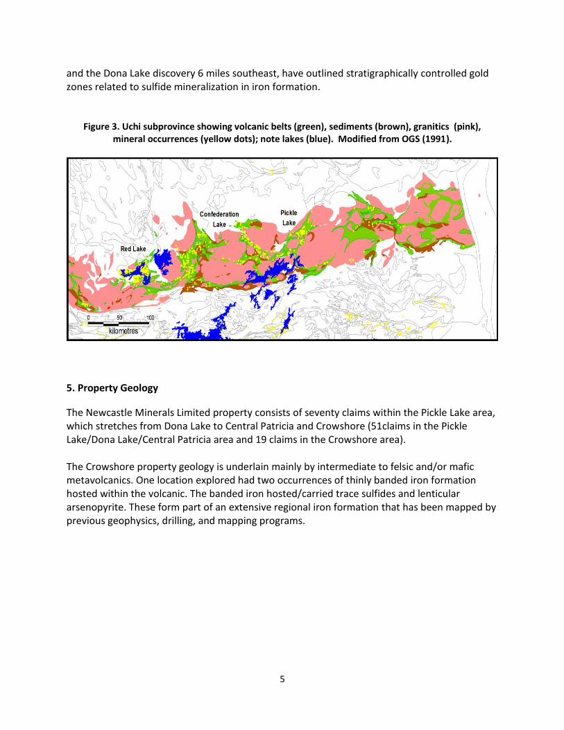
5. Property Geology ........................................................................................................................ 5
6. Mineralization ............................................................................................................................. 6
7. NCM 2011 Work Program ........................................................................................................... 7
8. Results of Analysis ....................................................................................................................... 8
9. Conclusion and Recommendations .......................................................................................... 11
10. References .............................................................................................................................. 12
11. Appendix A – Samples Photos ................................................................................................ 13
12. Appendix B – Claim List ........................................................................................................... 19
13. Appendix C – Certificates of Analysis ...................................................................................... 21
14. Appendix D – Fieldwork Log ………………………………………………………………………………………………38

iii
List of Figures
Figure 1: Location Map of Newcastle Minerals Ltd Pickle Lake Gold Project in Ontario Figure 2: Location of Crowshore North Outcrops, NCM Pickle Lake Gold Project Figure 3: Regional Geology of Northwest Ontario Figure 4: Property Geology Figure 5: Crowshore North Outcrop and Sample Locations
List of Tables
Table 1: Samples Description Table 2: Assay Results for Au and Ag

1
1. Introduction
The following report discusses the surface geological assessment and sampling program conducted by Billiken Management Services Inc. on Crowshore North Group property of Newcastle Minerals Ltd Pickle Lake Gold Project in Northwestern Ontario undertaken between October 23 and November 9, 2011, inclusive. The assessment covers the south middle portion of this group of claims specifically the southern half of Claim 4251344 and the northern half of Claim 4251339 where most of the identified surface outcrops are located. The area surveyed covers approximately 200 hectares. The Crowshore North Group comprises 11 claims totaling 2,720 hectares and is owned 100% by Newcastle. The claims cover the stratigraphic extension of the iron formation which is host to three past producing gold mines and multiple gold showings to the southwest of the property. Several areas of interest have been identified from a compilation of historic work on this claim group, which was prospected, mapped and sampled during this program. Historic work including diamond drilling returned some interesting gold values and several outcrop samples taken by previous operators warrant follow-up works with more modern techniques. Twenty-four rock samples were collected from the Crowshore North property from outcrops of banded iron and intermediate to felsic metavolcanics. These samples were analyzed for gold (Au) and silver (Ag) plus multi-element content. Personnel involved in the work were: Seela Lahti, Project Geologist, Ryan Metcalfe and Jayce Benson, Field Assistants. A total of 36 man-days were expended in this work. 2. Property Description and Location
The Crowshore North Group is comprised of 11 mining claims totaling 2,720 hectares which straddle the Kawinogans River in the First Loon Lake area of Northwestern Ontario (Figure 1). The claims (4251337 to 4251339 and 4251343 to 4251350) are part of the Pickle Lake Gold Project of Newcastle Minerals Limited which include the Western Claim Group and Crowshore Patents Group (Figure 2). The Crowshore North property is located approximately 350 km north of Thunder Bay, Ontario and 12 km northeast of Pickle Lake, Ontario. The area can be accessed by taking Highway 599 north from Ignace, Ontario to Highway 646 (or 464 on some maps) which leads to Pickle Lake. The property can be reached by canoeing down the Kawinogans River and by aluminum boat and motor. An ATV (6x6) was used to drive down a mud road on the PC Gold property for boat launching purposes. The patented claims can be accessed by a gravel road which goes through the PC Gold patented property. The outcrops in the area appear as continuous ridges protruding through the moss. Outcrops
are very scarce and cover roughly less than 1% of the property. The main rock types within the
2
area are intermediate to felsic metavolcanics (dacitic to andesitic) which host iron formations.
The massive flows are typically fine grained to very siliceous with trace disseminated sulfides
(i.e. pyrite).
The property is mainly covered with thick moss, 60/40 black spruce to jack pine (minor birch, tamarack, and poplar), Labrador tea, and widespread bogs.
Figure 1. Location Map of Newcastle Minerals Ltd Pickle Lake Gold Project in Ontario

3
Figure 2: Location of Crowshore North Outcrops, NCM Pickle Lake Gold Project
3. Previous Work
1937-1938 Surface exploration and diamond drilling by Crowshore Gold Mines. 1944 Surface exploration by Crowshore Patricia Gold Mines. 1945-1947 Exploration shaft sunk and underground exploration carried out by Crowshore Patricia Gold Mines. 1946 In 1946, Bankur Patricia Gold Mines Ltd. conducted a ground magnetics survey done on southwestern part of property on a 16 claim blocks which covered most of the Kaw River property. The survey confirmed the existence of banded iron formation on the property. One drill hole on the Bankur Patricia property contained iron formation and yielded 0.938 ppm gold over one foot.

4
1971 Airborne survey; EM surveys were flown over the Kaw River property. Three EM responses were delineated by a Spartan electromagnetic system, which lie along strike for about half a mile in the centre of the property.
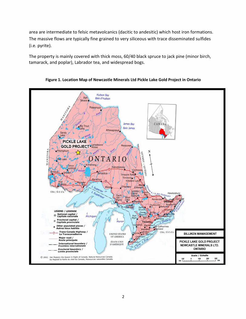
1972 Umex (Union Miniere Exploration Ltd.) drilled on the aeromagnetic anomaly and intersected 124 feet of banded iron formation and interbedded volcanic rocks. 1979-1980 Geophysical surveys by Prospecting Geophysics Ltd. 1981 Diamond drilling by Gallant Gold Mines. 1984 Van Horne Gold Exploration Inc. completed ground geophysical surveys and a field mapping program, (Gillick, 1984 and North, 1984) multiple bands of iron formation were detected. 1997 Wolfden Resources Inc. completed detailed magnetometer surveys in the area which indicated that the iron formation was strongly deformed. There is a correlation to intensity of deformation and presence of economic gold mineralization. 4. Regional Geology Pickle Lake is situated within the Uchi Subprovince, a part of the Superior Province of the Canadian Shield (Figure 3). The property is located within the Cat Lake/Pickle Lake sub-region of the Meen-Dempster greenstone belt. The area is characterized by several arcuate, highly deformed and coalescing greenstone belts. They consist of predominantly mafic to intermediate volcanic flows, which have been intruded by numerous granitic to ultramafic intrusive bodies. The metamorphic grade ranges from greenschist to amphibolite facies. The volcanic host subordinate amounts of felsic to mafic pyroclastics, sediments and iron formation. Felsic quartz-feldspar porphyry dykes are commonly found in all lithologies. (John H. Adams, B.Sc., 1986) Historically, gold production in the Pickle Lake area has been from structurally controlled, vein type deposits or sulphide replacement bodies spatially associated with, or contained within, bands of Algoman (chert-magnetite) iron formation. The Crowshore North property straddles the same band of iron formation that hosted the Pickle Crow and Central Patricia mines. Collectively, both mines have produced over 2,000,000 ounces of gold from 4,966,820 tons of ore with an average grade of 13 ppm. The Musselwhite deposit 50 miles north of Pickle Lake
5
and the Dona Lake discovery 6 miles southeast, have outlined stratigraphically controlled gold zones related to sulfide mineralization in iron formation.
Figure 3. Uchi subprovince showing volcanic belts (green), sediments (brown), granitics (pink), mineral occurrences (yellow dots); note lakes (blue). Modified from OGS (1991).
5. Property Geology
The Newcastle Minerals Limited property consists of seventy claims within the Pickle Lake area, which stretches from Dona Lake to Central Patricia and Crowshore (51claims in the Pickle Lake/Dona Lake/Central Patricia area and 19 claims in the Crowshore area). The Crowshore property geology is underlain mainly by intermediate to felsic and/or mafic metavolcanics. One location explored had two occurrences of thinly banded iron formation hosted within the volcanic. The banded iron hosted/carried trace sulfides and lenticular arsenopyrite. These form part of an extensive regional iron formation that has been mapped by previous geophysics, drilling, and mapping programs.

6
Figure 4. Geology of Pickle Lake Gold Project, Newcastle Minerals Ltd
6. Mineralization
Iron formation occurs at the northern location of the Crowshore North property which consisted of two separate banded iron formations roughly 40-50 meters apart in outcrop trending in a northeast to southwest direction with an average thickness ranging from 20-100 cm. The larger of the formations is a banded massive magnetite of 3-7cm thick bands with ≤1mm needle-like (lenticular) silver-white arsenopyrites. The smaller banded iron formation is more deformed and less massive and bands are not as defined as in the larger formation. Some minor sulfides can be seen disseminated throughout the formation. The adjacent units are intermediate to felsic metavolcanics typically fine grained and very siliceous with trace disseminated sulfides (i.e. pyrite). The source of the sulfides can be linked to replacement bodies which occupied shears, faults, fissures and fold axial plane fractures in highly deformed volcanics and iron formation.

7
7. NCM 2011 Work Program Twenty-four samples were collected during the course of the survey. Figure 4 shows the locations of visible outcrops where the rock samples were collected within the Crowshore North property. Table 1 shows the details of the rock samples collected.
Figure 5. Crowshore North Outcrop and Sample Locations
8
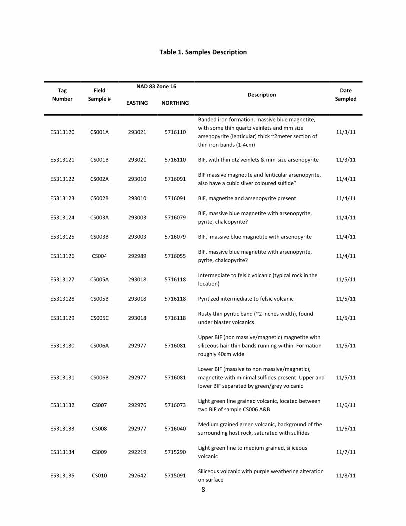
Table 1. Samples Description
Tag
Number
Field
Sample #
NAD 83 Zone 16
Description Date
Sampled EASTING NORTHING
E5313120 CS001A 293021 5716110
Banded iron formation, massive blue magnetite,
with some thin quartz veinlets and mm size
arsenopyrite (lenticular) thick ~2meter section of
thin iron bands (1-4cm)
11/3/11
E5313121 CS001B 293021 5716110 BIF, with thin qtz veinlets & mm-size arsenopyrite 11/3/11
E5313122 CS002A 293010 5716091 BIF massive magnetite and lenticular arsenopyrite,
also have a cubic silver coloured sulfide? 11/4/11
E5313123 CS002B 293010 5716091 BIF, magnetite and arsenopyrite present 11/4/11
E5313124 CS003A 293003 5716079 BIF, massive blue magnetite with arsenopyrite,
pyrite, chalcopyrite? 11/4/11
E5313125 CS003B 293003 5716079 BIF, massive blue magnetite with arsenopyrite 11/4/11
E5313126 CS004 292989 5716055 BIF, massive blue magnetite with arsenopyrite,
pyrite, chalcopyrite? 11/4/11
E5313127 CS005A 293018 5716118 Intermediate to felsic volcanic (typical rock in the
location) 11/5/11
E5313128 CS005B 293018 5716118 Pyritized intermediate to felsic volcanic 11/5/11
E5313129 CS005C 293018 5716118 Rusty thin pyritic band (~2 inches width), found
under blaster volcanics 11/5/11
E5313130 CS006A 292977 5716081
Upper BIF (non massive/magnetic) magnetite with
siliceous hair thin bands running within. Formation
roughly 40cm wide
11/5/11
E5313131 CS006B 292977 5716081
Lower BIF (massive to non massive/magnetic),
magnetite with minimal sulfides present. Upper and
lower BIF separated by green/grey volcanic
11/5/11
E5313132 CS007 292976 5716073 Light green fine grained volcanic, located between
two BIF of sample CS006 A&B 11/6/11
E5313133 CS008 292977 5716040 Medium grained green volcanic, background of the
surrounding host rock, saturated with sulfides 11/6/11
E5313134 CS009 292219 5715290 Light green fine to medium grained, siliceous
volcanic 11/7/11
E5313135 CS010 292642 5715091 Siliceous volcanic with purple weathering alteration
on surface 11/8/11

9
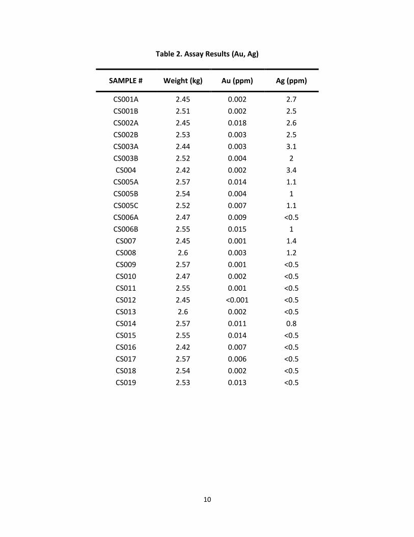
8. Results of Analysis No samples returned anomalous gold results. Gold values were low with the highest received
value of 0.018 ppm Au (grams/ton) from sample CS002A taken from a BIF. The majority of the
Au assays are less than 0.010 ppm. But it is interesting to note that samples with Au values
>0.010 ppm come from both the BIF and non-BIF horizons (Samples CS002A, CS005A, CS006B,
CS014, CS015 and CS019).
Silver values were also low, with 3.4 ppm being the highest value. The Ag value ranged from 3.4
ppm to <0.5 ppm in the banded iron formations. Again, it is interesting to note that all samples
taken from BIF returned Ag values greater than 1.0 ppm except for 1 sample (CS006A). The
surrounding metavolcanics contained little to no mineralization.
Although the samples did not return highly anomalous Au and Ag values, the assay results
suggest that Au values may be present in both BIF and immediate host rock while Ag content
appears to be concentrated in BIF horizons.
E5313136 CS011 292626 5715165 Light green fine to medium grained, siliceous
volcanic 11/8/11
E5313137 CS012 292711 5715149
Large quartz vein 3-4 meters in width, chloritic
alteration with k-spar, has grey colour alteration as
well within the quartz, dark grey/black
sediment/volcanic present as well
11/8/11
E5313138 CS013 292675 5715105 Light green fine grained volcanic, trace sulfides 11/8/11
E5313139 CS014 292828 5714587 Light green to green fine to medium grained
volcanic, large pyrite cubes (0.5-1.5cm) 11/8/11
E5313140 CS015 293419 5715320 Fine light green volcanic, trace sulfides present, thin
cutting veinlets throughout (quartz?) 11/9/11
E5313141 CS016 293387 5715284
Poor outcrop sample, hard to find location that
would break using just a rock hammer, weathered
light green fine grained volcanic
11/9/11
E5313142 CS017 293340 5715263 Light green fine grained volcanic, siliceous with
biotite present, trace sulfides 11/9/11
E5313143 CS018 293212 5715201 Light green fine grained volcanic, siliceous with
biotite present, trace sulfides 11/9/11
E5313144 CS019 293149 5715475
Light green fine grained volcanic, siliceous with
biotite present, trace sulfides, slight quartz veining
throughout
11/9/11
10
Table 2. Assay Results (Au, Ag)
SAMPLE # Weight (kg) Au (ppm) Ag (ppm)
CS001A 2.45 0.002 2.7
CS001B 2.51 0.002 2.5
CS002A 2.45 0.018 2.6
CS002B 2.53 0.003 2.5
CS003A 2.44 0.003 3.1
CS003B 2.52 0.004 2
CS004 2.42 0.002 3.4
CS005A 2.57 0.014 1.1
CS005B 2.54 0.004 1
CS005C 2.52 0.007 1.1
CS006A 2.47 0.009 <0.5
CS006B 2.55 0.015 1
CS007 2.45 0.001 1.4
CS008 2.6 0.003 1.2
CS009 2.57 0.001 <0.5
CS010 2.47 0.002 <0.5
CS011 2.55 0.001 <0.5
CS012 2.45 <0.001 <0.5
CS013 2.6 0.002 <0.5
CS014 2.57 0.011 0.8
CS015 2.55 0.014 <0.5
CS016 2.42 0.007 <0.5
CS017 2.57 0.006 <0.5
CS018 2.54 0.002 <0.5
CS019 2.53 0.013 <0.5

11
9. Conclusion and Recommendation The iron formation at the southern portion of Crowshore North property forms a continuous zone towards the Crowshore Patents to the southwest with a strike length of approximately 7-8 km. The same iron formation has been the host to several past producing gold mines and several gold showings southwest of the Crowshore North property. This property has been shown much less attention than other areas due to a thick cover of overburden. This makes geological mapping and prospecting difficult. The recent detailed magnetometer survey completed by Wolfden Resources Inc. has identified strongly folded areas in the iron formation which contain breaks in the magnetics. These structural breaks and offsets are known to be prospective areas for Au mineralization. While no surface Au showings were found during the recent survey, previous works have shown potentials for discoveries of mineralized zones. Given that the Crowshore North property overlays the stratigraphic extension of the iron formation which hosted three past producing gold mines and zones of strong deformation have been identified, the Crowshore North property has very good potential for hosting gold mineralization. Although the 24 samples collected did not return highly anomalous Au and Ag values, the assay
results suggest that Au values may be present in both BIF and immediate host rock while Ag
values appear to be concentrated in BIF horizons.
Due to the limited occurrence of surface outcrops in this group of claims, it is recommended that a review and re-interpretation of historic geophysical surveys be undertaken to identify local geologic structures and potential anomalous areas which could be the basis for further ground verification surveys elsewhere within the Crowshore North Claims.

12
REFERENCES
Jon W. North, H.B.Sc., (1984): Report on Geological Mapping and Geochemical Sampling, Kaw River Property, First Loon Lake Area, Patricia Mining Division, N.W. Ontario for Van Horne Gold Exploration Inc., N.T.S. 52P/12 SW
J.A. Goodwin, (1985): Billiton Canada Ltd., Geological Survey of the Firstloon Lake Property, Pickle Lake Area, N.W. Ontario, N.T.S. 52P/12W
J.L. Wahl, Ph.D.,
(1985): Kerr Addison Mines Limited, Report on, Geological Mapping- Geophysical Surveys, Kerr-Pickle Project, Tarp Lake Group, Northwestern Ontario
John H. Adams, B.Sc., (1986): Report on Geochemical Soil Sampling on the Kaw River Property, Pickle Lake Area, Patricia Mining Division, Northwestern Ontario, for 669977 Ontario Ltd., NTS 52 - P/12 David V. Mullen, (1987): UMEX Inc. Geological Assessment Report, Tarp Lake Option, Tarp Lake Area, District of Kenora, Patricia Portion NTS 52-0-9 M. A. Puumala, (2007): Kaw River- 1990, First Loon Lake #1- 1990. Revised Version, MDI Number: MDI52P12SW00004 M. A. Puumala, (2007): Crow Shore Patricia- 1984, Tarp Lake D- 1984. Revised Version, MDI Number: MDI52O09SE00006

13
Appendix A
Rock Sample Photos

14
Photo 1. Samples CS001A to CS003B

15
Photo 2. Samples CS004 to CS006B

16
Photo 3. Samples CS007 to CS012

17
Photo 4. Samples CS013 to CS018

18
Photo 5. Sample CS019

19
Appendix B
Claim List

20
Newcastle Minerals Limited
List of Claims
Crowshore Patents Crowshore North Group
PA2586 4251337
PA90 4251338
PA91 4251339
PA92 4251343
PA93 4251344
PA94 4251345
PA95 4251346
PA96 4251347
4251348
4251349
4251350

21
Appendix C
Certificates of Analysis

22

23

24

25

26

27

28

29
30

31

32

33

34
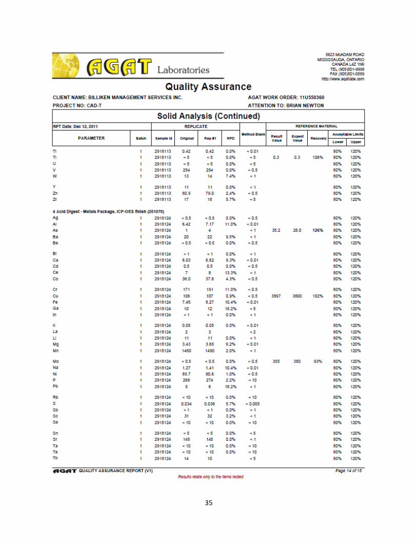
35

36

37

38
Appendix D
Field Work Log

39
Field Work Log
Date (2011) Description
October 23rd to October 24th We got permission to enter through PC
Gold’s property and drove down to the Old
Crow Shore Mine site. Here we started to
investigate the location looking for signs of
outcrops. The surface was covered too
heavily by vegetation and none were found,
however we did come across some old rock
dumps near the old mine shaft.
October 25th Launched the canoe from the highway and
paddled down the Kawinogans River to a
reachable site near the Crow Shore property.
October 26th to November 1st Canoed then hiked to various known
outcrops throughout the North Crow Shore
properties. We found that most of the
outcrops had little to no mineralization or
exposed iron formation (metavolcanics). Only
one site was found to have banded iron
formation, and from there we started
sampling.
November 2nd Brought the blasting equipment to the BIF
site and set up for next day.
November 3rd Started blasting and collected two samples,
CS001A and CS001B.
November 4th Acquired a small motor boat which saved a
large portion of travel time. Due to the time
saved sampling was accomplished in a faster
rate. Five samples were collected this day,
CS002A/B/C, CS003A/B, CS004.
November 5th Continued sampling at the BIF location,
sampled some of the host intermediate to
felsic volcanics and started sampling the

40
smaller exposed BIF. Another five samples
were collected, CS005A/B/C and CS006A/B.
November 6th We finished sampling the smaller of the BIF
and also took another background sample of
the host volcanics. [CS007 and CS008] After
sampling was completed we packed
everything up and moved to the next
sampling location.
November 7th Base camp was set up and one sample was
collected as the location was quite far.
[CS009]
November 8th CS010 to CS014 were collected from the host
volcanic rock. Base camp then was packed up
and moved to final sampling location as the
weather was starting to turn for the worst.
November 9th The river was half frozen as we made our way
to the last sampling site, we set up and
collected the final five samples CS015 to
CS019.