REPORT ON EXPEDITION/PROJECT/CONFERENCE
18
REPORT ON EXPEDITION/PROJECT/CONFERENCE Expedition/Project/ Conference Title: Megatransect Sumatra Travel Dates: 08.06.2016 – 08.08.2016 Location: Sumatra, Indonesia Group member(s): Iris Berger, Oliver Broadhead Aims: We will undertake a two-month expedition crossing the island of Sumatra on foot, cataloguing species as we encounter them, with the aim of comparing deforested areas with protected forests and giving a first insight into avian biodiversity in an area previously unexplored by scientists. OUTCOME (not less than 300 words):- Megatransect Sumatra Introduction The biogeographical region Sundaland, which Sumatra belongs to, is the third greatest biodiversity hotspot in the world (Myers et al., 2000). However, Indonesia has been estimated to have the highest rate of primary forest clearing globally, with Sumatra showing the greatest rate of loss out of all Indonesian island groups (Margono et al., 2014). Hence, drastic conservation management programmes are urgently needed. In Sumatra 397 bird species are present with 6% of them being endemic (MacKinnon and Phillips, 1993). There are 11 national parks in Sumatra, however, even those areas are far from free from the impacts of illegal logging and poaching. Moreover, vast areas are completely unexplored by scientists and thus require urgent attention which was the motivation for this expedition. This study was composed of two parts, where the first part was conducted in the pristine montane rainforests around Mount Lembu, Aceh, Northern Sumatra (N 04° 13’ 18.3” E 097° 26’ 05.9”, 3043m) and the second part involved traversing various landscapes of high human influence. A record of the species encountered allowed a comparison of avian biodiversity between the two areas and considering that, until now, no research has ever been conducted in the forests around Mount Lembu the data collected provides valuable insight into the importance of that region to conservation. Methods Part 1: Mount Lembu A transect from the village Uring (N 04° 03’ 38.5” E 097° 27’ 47.9”, 835m) to the summit of Mount Lembu (N 04° 13’ 18.3” E 097° 26’ 05.9”, 3043m) and back again following the same route was conducted (23km each way). The route taken is illustrated in Figure 1.
Transcript of REPORT ON EXPEDITION/PROJECT/CONFERENCE

REPORT ON EXPEDITION/PROJECT/CONFERENCE Expedition/Project/ Conference Title:
Megatransect Sumatra
Travel Dates:
08.06.2016 – 08.08.2016
Location:
Sumatra, Indonesia
Group member(s):
Iris Berger, Oliver Broadhead
Aims:
We will undertake a two-month expedition crossing the island of Sumatra on foot, cataloguing species as we encounter them, with the aim of comparing deforested areas with protected forests and giving a first insight into avian biodiversity in an area previously unexplored by scientists.
OUTCOME (not less than 300 words):-
Megatransect Sumatra
Introduction
The biogeographical region Sundaland, which Sumatra belongs to, is the third greatest
biodiversity hotspot in the world (Myers et al., 2000). However, Indonesia has been
estimated to have the highest rate of primary forest clearing globally, with Sumatra showing
the greatest rate of loss out of all Indonesian island groups (Margono et al., 2014). Hence,
drastic conservation management programmes are urgently needed.
In Sumatra 397 bird species are present with 6% of them being endemic (MacKinnon and
Phillips, 1993). There are 11 national parks in Sumatra, however, even those areas are far
from free from the impacts of illegal logging and poaching. Moreover, vast areas are
completely unexplored by scientists and thus require urgent attention which was the
motivation for this expedition.
This study was composed of two parts, where the first part was conducted in the pristine
montane rainforests around Mount Lembu, Aceh, Northern Sumatra (N 04° 13’ 18.3” E 097°
26’ 05.9”, 3043m) and the second part involved traversing various landscapes of high human
influence. A record of the species encountered allowed a comparison of avian biodiversity
between the two areas and considering that, until now, no research has ever been conducted
in the forests around Mount Lembu the data collected provides valuable insight into the
importance of that region to conservation.
Methods
Part 1: Mount Lembu
A transect from the village Uring (N 04° 03’ 38.5” E 097° 27’ 47.9”, 835m) to the summit of
Mount Lembu (N 04° 13’ 18.3” E 097° 26’ 05.9”, 3043m) and back again following the same
route was conducted (23km each way). The route taken is illustrated in Figure 1.

Figure 1: Map of the route taken in the Mount Lembu area. The topography and position of camps is indicated.
Whilst birds and mammals were recorded if encountered, the study was mainly aimed at
assessing avian diversity. This was mainly due to the pace by which we travelled and due to
the abundance of birds. A representation of reptile and amphibian diversity would have
required covering an extremely small distance and moving at night which was not feasible for
this expedition. Due to the elusiveness and relatively low abundance of mammals, their
diversity is usually ascertained with camera traps which were beyond our budget.
Nevertheless, if we did encounter any mammals and we were able to identify them
successfully (either by visual or acoustic signals) we did record them. The mammal
identification guidebook Shepherd and Shepherd (2012) was used.
Since it is practically impossible to document every single bird encountered we followed
MacKinnon and Phillipps’ (1993) method. A list of every new bird species was made until a
census of 20 species was reached and then a new list was started. A species was only
recorded once in each list, but was noted again in subsequent lists. All species identified are
listed, giving a value of the areas biodiversity, and the number of lists a species appears on
gives an idea of its abundance. The strength of this system is that it is relatively independent
of observer expertise, bird watching intensity, weather conditions and other factors. Species
were identified using MacKinnon and Phillipps’ (1993) guidebook and notes on GPS
coordinates, altitude, habitat type, weather conditions, time and date, and any additional
observations were taken.
Part 2: Human influenced area

The route taken was from Ketambe (N 03°39'05.165'' E 097°40'45.337'', 440m) to Barus (N
02°01'19.322'' E 098°37'46.187'', 8m), covering approximately 350km, and the methodology
used was the same as for Part 1 (Figure 2).
Figure 2: Route taken during the second part of the expedition crossing a range of areas under strong human influence.
Results
The raw data of the birds (Table 1-2) and mammals (Table 3-4) recorded can be found in the
Appendix. The accumulative total number of species is 49 in the forests around Mount
Lembu (out of 53 total recordings) and 42 in the strongly human influenced area (out of 55
recordings in total). This implies that 92.5% of the total recordings were a new species not
recorded in a previous list in the pristine forests, whereas the value was merely 76.4% for the
human altered areas.
Species that occur on many lists are very abundant and/or conspicuous of the respective
local avifauna. In the pristine forests only four species were recorded more than once,
namely Alcedo euryzona (Blue-banded Kingfisher), Brachypteryx montana saturate (White-
browed Shortwing), Dicrurus sumatranus (Sumatran Drongo), and Ficedula hyperythra
(Snowy-browed Flycatcher).
Information and the significance of the birds recorded in the forests around Mount Lembu is
given below.
Collocalia maxima (Black-nest Swiftlet): Often found near limestone caves and their nests
are often harvested for sale.
Acridotheres javanicus (Javan Myna): It is not native in Sumatra, but is probably the result of
an escaped cage release in Medan area and is locally common. Often found near paddy
fields and near open grassy fields.
Lonchura maja (White-headed Munia): Common and widespread, up to 1500m
Streptopelia bitorquata (Island Collard Dove): Probably an escape in Sumatra, usually rarely
found above 600m and mainly found in mangroves, however, we sighted the species at
870m near paddy fields.
Copsychus saularis (Oriental Magpie-robin): Relatively common in villages and secondary
forests up to 1500m.
Psilopogon pyrolophus (Fire-tufted Barbet): Usually found between 500 and 1500m foraging
in the canopy. Whilst it is classified as Least Concern under the IUCN illegal capture for the
pet trade have caused the population to decrease. The individuals we encountered were all
killed by a shotgun carried back to Uring by five poachers.
Megalaima oorti (Black-browed Barbet): Common in montane forests between 1000 and
2000m, typically in the middle and upper canopy.
Alcedo meninting (Blue-eared Kingfisher): Found by freshwater streams up to 1000m.
Alcedo euryzona (Blue-banded Kingfisher): Similar habitats to the Blue-eared kingfisher,
predominately sub-montane.
Muscicapa dauurica (Asian Brown Flycatcher): Up to 1500m, hilly or submontane forests
preferred.
Cinclidium diana (Sunda Blue Robin): Known to be found in the undergrowth of high
montane forests in low numbers in Sumatra (between 1100 and 1500m), albeit we recorded
the species at 889m.
Copsychus malabaricus (White-rumped Shama): Up to 1500m in dense forests.
Dendrocitta occipitalis (Sumatran Treepie): Endemic to Sumatra. Found in tall forests from
400-2300m.
Myiophoneus melanurus (Shiny Whistling-thrush): Usually near water in primary hill and
montane forests, between 800 and 3300m.
Brachypteryx montana saturate (White-browed shortwing): Extremely large range. Usually
locally common between 1400 and 3000m, however, we sighted the species at 100m. Often
near streams, but variable in its habitat.
Buceros bicornis (Great Hornbill): Whilst it has a large range, it occurs at low densities and is
thus classified as Near Threatened. It is uncommon on Sumatra where it has shown a
significant decline following recent devastation of the island's lowland forest.
Megalaima chrysopogon (Golden-whiskered Barbet): Forages in the canopy of trees. Patchy
geographic range in northern Sumatra.
Stachyris rufifrons (Rufous-fronted Babbler): Rare in Sumatra.
Rhipidura javanica (Pied fantail): Thought to be present up to 1500m, however, we recorded
the species at 2095m.
Pycnonotus leucogrammicus (Cream-striped Bulbul): Recorded at 2095m which is higher
than the previously though range of up to 1900m.
Pycnonotus melanoleucos (Black-and-white Bulbul): A poorly known species with few
records in Sumatra.
Dicrurus sumatranus (Sumatran Drongo): Common in lowland forests, however, we recorded
it at 2425m.
Ixos malaccensis (Streaked Bulbul): The species is thought to be present mainly below
1200m, however, we sighted it at 2243m. Habitat loss has caused a population decline.

Dicrurus aeneus (Bronzed Drongo): Usually found in primary and secondary lowland forests
up to 1400m, albeit we recorded it at 2243m.
Arachnothera longirostra (Little Spiderhunter): Again observed above the previously thought
maximum altitude of 2000m.
Eudynamys scolopacea (Asian Koel): A widespread cuckoo keeping to dense cover.
Garrulax palliatus (Sunda Laughingthrush): Endemic to Sumatra and Borneo, found in the
lower and middle canopy of montane forests.
Pericrocotus flammeus (Scarlet Minivet): Thought to be locally common in primary forest up
to 1500m, but we sighted the species at 2243m.
Prionochilus percussus (Crimson-breasted Flowerpecker): Recorded at 2243m which is
significantly higher than the previously though range of up to 1000m.
Ficedula hyperythra (Snowy-browed Flycatcher): Extremely large range.
Culicicapa ceylonensis (Grey-headed Flycatcher): Common in sub montane forests.
Stachyris chrysaea (Golden Babbler): Common in hill and montane forests between 800 and
3000m in Sumatra.
Ictinaetus malayensis (Black Eagle): Sparsely but widely distributed throughout the Greater
Sundas.
Zoothera dauma (Scaly Thrush): Rare resident of the mountains in North Sumatra. Feeds on
the ground in dense forests.
Enicurus leschenaulti (White-crowned Forktail): Usually confined to lowland and hill streams
up to 1400m, however, we observed the species at 3043m.
Dendrocitta occipitalis (Sumatran Treepie): Endemic to Sumatra at altitudes of up to 2300m.
Pycnonotus zeylanicus (Straw-headed Bulbul): Found in the lowlands and hills, albeit we
sighted it at 2325m.
Garrulax mitratus mitratus (Chestnut-capped Laughingthrush): A common bird in mountain
forests.
Alophoixus bres (Grey-cheeked Bulbul): Thought to be local in lowland forests, active in the
lower canopy.
Enicurus velatus (Lesser Forktail): In Sumatra common in hill and mountain forests.
Arachnothera flavigaster (Spectacled Spiderhunter): Generally found in secondary forests.
Largest member of its family.
Loriculus galgulus (Blue-crowned Hanging Parrot): Common in lowland forests throughout
Sumatra.
Dicrurus leucophaeus (Ashy Drongo): Common in open woodlands. Lives in pairs.
Halcyon smyrnensis (White-throated Kingfisher): Extremly wide range. Replacing the Collard
Kingfisher as the common kingfisher in Sumatra.
Pycnonotus tympanistrigus (Spot-necked Bulbul): Endemic to Sumatra. Little is known about
the species with habitat loss posing a threat.
Iole viresceus sumatranus (Sunda Bulbul): Locally common in sub-montane forests.
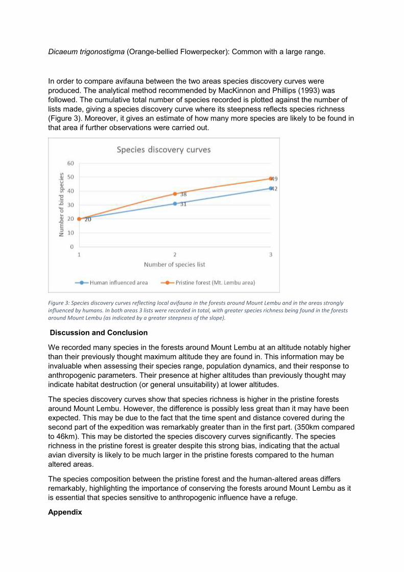
Dicaeum trigonostigma (Orange-bellied Flowerpecker): Common with a large range.
In order to compare avifauna between the two areas species discovery curves were
produced. The analytical method recommended by MacKinnon and Phillips (1993) was
followed. The cumulative total number of species recorded is plotted against the number of
lists made, giving a species discovery curve where its steepness reflects species richness
(Figure 3). Moreover, it gives an estimate of how many more species are likely to be found in
that area if further observations were carried out.
Figure 3: Species discovery curves reflecting local avifauna in the forests around Mount Lembu and in the areas strongly influenced by humans. In both areas 3 lists were recorded in total, with greater species richness being found in the forests around Mount Lembu (as indicated by a greater steepness of the slope).
Discussion and Conclusion
We recorded many species in the forests around Mount Lembu at an altitude notably higher
than their previously thought maximum altitude they are found in. This information may be
invaluable when assessing their species range, population dynamics, and their response to
anthropogenic parameters. Their presence at higher altitudes than previously thought may
indicate habitat destruction (or general unsuitability) at lower altitudes.
The species discovery curves show that species richness is higher in the pristine forests
around Mount Lembu. However, the difference is possibly less great than it may have been
expected. This may be due to the fact that the time spent and distance covered during the
second part of the expedition was remarkably greater than in the first part. (350km compared
to 46km). This may be distorted the species discovery curves significantly. The species
richness in the pristine forest is greater despite this strong bias, indicating that the actual
avian diversity is likely to be much larger in the pristine forests compared to the human
altered areas.
The species composition between the pristine forest and the human-altered areas differs
remarkably, highlighting the importance of conserving the forests around Mount Lembu as it
is essential that species sensitive to anthropogenic influence have a refuge.
Appendix


Table 1: List of the bird species recorded during the first part of the expedition in the forests around Mount Lembu. Information on the GPS coordinates, elevation, habitat type, date, time, weather conditions, and any additional notes that were taken is given. There are three lists in total, the first two lists having 20 species each, whereas 14 species were recorded for the last list.
Pristine forest (Mt. Lembu area) - Birds Species GPS Elevation
(m) Habitat Date Time Weather Additional notes
LIST 1
Collocalia maxima N 04°04'03.4'' E 097°27'36.6''
870 paddy field 16.06.2016 11:50 90% cloud very common, many dragonflies
Acridotheres javanicus
N 04°04'03.4'' E 097°27'36.6''
870 paddy field 16.06.2016 12:00 90% cloud
Lonchura maja N 04°04'03.4'' E 097°27'36.6''
870 paddy field 16.06.2016 13:00 90% cloud
Streptopelia bitorquata
N 04°04'03.4'' E 097°27'36.6''
870 paddy field 16.06.2016 12:20 90% cloud
Copsychus saularis N 04°04'23.3'' E 097°27'24.0''
885 riverbed in cloud forest
16.06.2016 13:00 90% cloud low water levels, hornet nests, Mimosa pudica present
Psilopogon pyrolophus
N 04°05'00.1'' E 097°27'34.4''
885 riverbed in cloud forest
16.06.2016 13:05 90% cloud Dead, around 20 individuals, 5 poachers
Megalaima oorti N 04°05'00.1'' E 097°27'34.4''
885 riverbed in cloud forest
16.06.2016 14:00 90% cloud
Alcedo meninting N 04°05'27.4'' E 097°27'35.8''
889 riverbed in cloud forest
16.06.2016 16:00 90% cloud
Alcedo euryzona N 04°05'27.4'' E 097°27'35.8''
889 riverbed in cloud forest
16.06.2016 17:47 90% cloud
Muscicapa dauurica N 04°05'27.4'' E 097°27'35.8''
889 riverbed in cloud forest
16.06.2016 18:10 90% cloud
Cinclidium diana N 04°05'27.4'' E 097°27'35.8''
889 riverbed in cloud forest
16.06.2016 19:10 90% cloud
Copsychus malabaricus
N 04°06'20.4'' E 097°27'45.8''
911 riverbed in cloud forest
17.06.2016 08:00 90% cloud, light rain
Pericrocotus spp. N 04°06'20.4'' E 097°27'45.8''
911 riverbed in cloud forest
17.06.2016 08:00 90% cloud, light rain

Dendrocitta occipitalis
N 04°06'21.2'' E 097°27'49.8''
1000 riverbed in cloud forest
17.06.2016 11:20 100% cloud
Myiophoneus melanurus
N 04°06'21.2'' E 097°27'49.8''
1000 riverbed in cloud forest
17.06.2016 11:30 100% cloud
Brachypteryx montana saturata
N 04°06'21.2'' E 097°27'49.8''
1000 riverbed in cloud forest
17.06.2016 12:10 100% cloud
Buceros bicornis N 04°06'21.2'' E 097°27'49.8''
1000 riverbed in cloud forest
18.06.2016 08:00 50% cloud 6 individuals, feeding on fruit
Megalaima chrysopogon
N 04°06'21.2'' E 097°27'49.8''
1000 riverbed in cloud forest
18.06.2016 09:30 50% cloud
Stachyris rufifrons N 04°08'16.7'' E 097°28'24.1''
2095 mossy cloud forest
19.06.2016 14:20 foggy many Nepenthes pitcher plant
LIST 2
Rhipidura javanica N 04°08'16.7'' E 097°28'24.1''
2095 mossy cloud forest
19.06.2016 15:10 foggy up and down movement of tail
Pycnonotus leucogrammicus
N 04°08'16.7'' E 097°28'24.1''
2095 mossy cloud forest
19.06.2016 15:15 foggy
Pycnonotus melanoleucos
N 04°08'16.7'' E 097°28'24.1''
2095 mossy cloud forest
19.06.2016 16:00 foggy
Dicrurus sumatranus N 04°09'13.8'' E 097°27'17.8''
2425 mossy scrub 20.06.2016 13:37 60% cloud v exposed ridge, stumpy trees, v windy, many Nepenthes pitcher plant
Ixos malaccensis N 04° 11' 48.7'' E 097° 25' 44.2''
2243 cloud forest 22.06.2016 15:00 50%cloud on branch by small stream
Dicrurus aeneus N 04° 11' 48.7'' E 097° 25' 44.2''
2243 cloud forest 22.06.2016 11:00 50%cloud riverbed, on branch
Arachnothera longirostra
N 04° 11' 48.7'' E 097° 25' 44.2''
2243 cloud forest 23.06.2016 07:45 70% cloud on branch
Eudynamys scolopacea
N 04° 11' 48.7'' E 097° 25' 44.2''
2243 cloud forest 23.06.2016 08:00 70% cloud low branch by river, curious, v close
Garrulax palliatus N 04° 11' 48.7'' E 097° 25' 44.2''
2243 cloud forest 23.06.2016 11:20 80% cloud hopping on branch
Pericrocotus N 04° 11' 48.7'' E 2243 cloud forest 23.06.2016 15:00 100% cloud large flock (20-30 individuals), calling

flammeus 097° 25' 44.2''
Brachypteryx montana saturata
N 04° 11' 48.7'' E 097° 25' 44.2''
2243 cloud forest 23.06.2016 15:10 100% cloud, light rain
pair
Prionochilus percussus
N 04° 11' 48.7'' E 097° 25' 44.2''
2243 cloud forest 23.06.2016 15:15 100% cloud, light rain
female, bath in raindrops on fern
Ficedula hyperythra N 04° 11' 48.7'' E 097° 25' 44.2''
2243 cloud forest 24.06.2016 14:00 100% cloud low branches, around 2m away
Culicicapa ceylonensis
N 04° 12' 34.5'' E 097° 25' 40.8''
2606 cloud forest 25.06.2016 11:20 70%cloud
Stachyris chrysaea N 04° 12' 34.5'' E 097° 25' 40.8''
2606 cloud forest 25.06.2016 11:30 70% cloud
Ictinaetus malayensis N 04° 13' 15.0'' E 097° 26' 02.9''
3033 mossy cloud forest
25.06.2016 12:20 80% cloud
Zoothera dauma N 04° 13' 18.3'' E 097° 26' 05.9''
3043 mossy cloud forest
26.06.2016 14:10 40% cloud
Enicurus leschenaulti N 04° 13' 18.3'' E 097° 26' 05.9''
3043 mossy cloud forest
26.06.2016 14:30 40% cloud
Dendrocitta occipitalis
N 04°09'00.5'' E 097°27'00.3''
2325 mossy cloud forest
28.06.2016 13:00 70% cloud windy, 20m away from the top of the ridge
Pycnonotus zeylanicus
N 04°09'00.5'' E 097°27'00.3''
2325 mossy cloud forest
28.06.2016 13:10 70% cloud
LIST 3
Ficedula hyperythra N 04°09'00.5'' E 097°27'00.3''
2325 mossy cloud forest
28.06.2016 13:15 70% cloud
Dicrurus sumatranus N 04°09'00.5'' E 097°27'00.3''
2325 mossy cloud forest
28.06.2016 13:15 70% cloud
Garrulax mitratus mitratus
N 04°09'00.5'' E 097°27'00.3''
2325 mossy cloud forest
28.06.2016 14:00 70% cloud
Alophoixus bres N 04°06'21.2'' E 097°27'49.8''
1000 riverbed in cloud forest
29.06.2016 11:00 20% cloud many butterflies, river level dropped compared to ascent
Enicurus velatus N 04°06'21.2'' E 097°27'49.8''
1000 riverbed in cloud forest
29.06.2016 11:10 20% cloud many butterflies, river level dropped compared to ascent

Arachnothera flavigaster
N 04°06'21.2'' E 097°27'49.8''
1000 riverbed in cloud forest
29.06.2016 12:10 20% cloud many butterflies, river level dropped compared to ascent
Loriculus galgulus N04°05'05'' E97°27'0.2''
912 riverbed in cloud forest
30.06.2016 06:30 10% cloud observed from camp
Dicrurus leucophaeus N04°05'05'' E97°27'0.2''
912 riverbed in cloud forest
30.06.2016 06:30 10% cloud observed from camp
Alcedo euryzona N04°05'0.01'' E97°27'34.4''
950 riverbed near paddy field
30.06.2016 08:20 10% cloud
Halcyon smyrnensis N04°05'0.01'' E97°27'34.4''
950 riverbed near paddy field
30.06.2016 08:30 10% cloud
Pycnonotus tympanistrigus
N04°05'0.01'' E97°27'34.4''
950 riverbed near paddy field
30.06.2016 08:30 10% cloud
Iole viresceus sumatranus
N04°05'0.01'' E97°27'34.4''
950 riverbed near paddy field
30.06.2016 11:00 10% cloud
Dicaeum trigonostigma
N04°05'0.01'' E97°27'34.4''
950 riverbed near paddy field
30.06.2016 11:50 10% cloud
Table 2: List of the bird species recorded during the second part of the expedition in the areas strongly influenced by humans. Information on the GPS coordinates, elevation, habitat type, date, time, weather conditions, and any additional notes that were taken is given. There are three lists in total, the first two lists having 20 species each, whereas 15 species were recorded for the last list.
Human influenced area - Birds Species GPS Elevation (m) Habitat Date Time Weather Additional notes
LIST 1
Harpactes orrhophaeus
N 03°39'05.165'' E 097°40'45.337''
440 cloudforest 06.07.2016 10:00 10% cloud tourist trail, with guide
Reinwardtipicus validus
N 03°39'05.165'' E 097°40'45.337''
440 cloudforest 06.07.2016 11:10 10% cloud tourist trail, with guide
Cuculus micropterus N 03°39'05.165'' E 097°40'45.337''
440 cloudforest 06.07.2016 13:20 20% cloud tourist trail, with guide
Ictinaetus malayensis
N 03°22'07.145'' E 097°40'46.386''
1055 farmland, small villages
07.07.2016 10:00 10% cloud riverbed next to main road

Passer montanus N 03°22'07.145'' E 097°40'46.386''
1055 farmland, small villages
08.07.2016 07:00 10% cloud
Anthreptes simplex N 03°22'07.145'' E 097°40'46.386''
1055 farmland, small villages
08.07.2016 07:10 10% cloud
Acridotheres javanicus
N 03°22'07.145'' E 097°40'46.386''
1055 farmland, small villages
08.07.2016 18:00 10% cloud on coconut tree
Collocalia maxima N 03°20'01.133'' E 097°32'16.446''
801 farmland, small villages
09.07.2016 14:20 30% cloud
Geopelia striata N 03°20'01.553'' E 097°19'16.553''
844 cornfield 10.07.2016 15:10 40% cloud
Columba livia domestica
N 03°50'22.543'' E 097°32'19.583''
844 farmland, small villages
11.07.2016 08:30 80% cloud
Ixobrychus cinnamomeus
N 03°20'01.553'' E 097°19'16.553''
paddy field 12.07.2016 07:00 80% cloud
Bubulcus ibis N 03°20'01.553'' E 097°19'16.553''
paddy field 12.07.2016 07:00 80% cloud
Lonchura maja N 03°20'01.553'' E 097°19'16.553''
cornfield 12.07.2016 08:00 80% cloud
Pycnonotus aurigaster
N 03°13'11.532'' E 098°12'16.713''
farmland, small villages
12.07.2016 11:00 70% cloud
Lanius schach bentet N 03°13'11.532'' E 098°12'16.713''
farmland, small villages
12.07.2016 11:00 70% cloud
Oriolus chinensis N 03°13'11.532'' E 098°12'16.713''
farmland, small villages
12.07.2016 11:00 70% cloud
Dicrurus leucophaeus
N 03°13'11.532'' E 098°12'16.713''
farmland, small villages
12.07.2016 11:10 70% cloud
Pycnonotus tympanistrigus
N 03°13'11.532'' E 098°12'16.713''
farmland, small villages
12.07.2016 11:10 70% cloud
Amaurornis phoenicurus
N 03°11'01.532'' E 098°02'12.333''
reed bed 12.07.2016 16:30 80% cloud
Elanus caeruleus N 03°11'01.532'' E 098°02'12.333''
farmland, small villages
12.07.2016 17:00 80% cloud
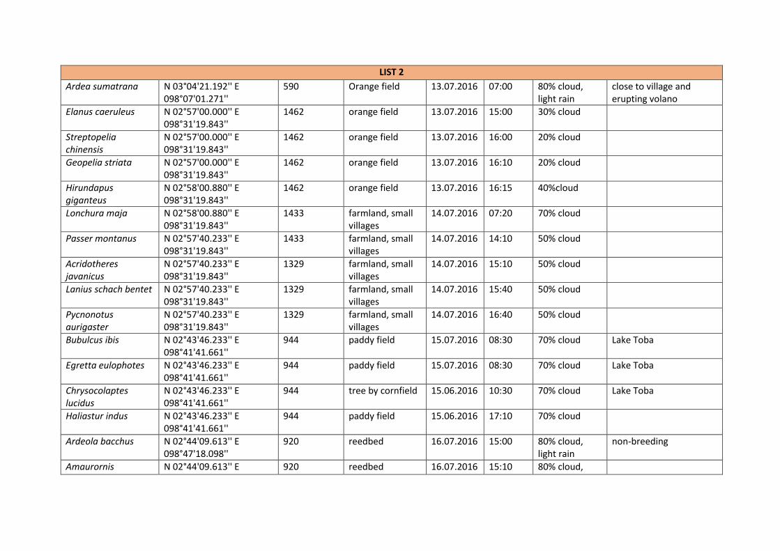
LIST 2
Ardea sumatrana N 03°04'21.192'' E 098°07'01.271''
590 Orange field 13.07.2016 07:00 80% cloud, light rain
close to village and erupting volano
Elanus caeruleus N 02°57'00.000'' E 098°31'19.843''
1462 orange field 13.07.2016 15:00 30% cloud
Streptopelia chinensis
N 02°57'00.000'' E 098°31'19.843''
1462 orange field 13.07.2016 16:00 20% cloud
Geopelia striata N 02°57'00.000'' E 098°31'19.843''
1462 orange field 13.07.2016 16:10 20% cloud
Hirundapus giganteus
N 02°58'00.880'' E 098°31'19.843''
1462 orange field 13.07.2016 16:15 40%cloud
Lonchura maja N 02°58'00.880'' E 098°31'19.843''
1433 farmland, small villages
14.07.2016 07:20 70% cloud
Passer montanus N 02°57'40.233'' E 098°31'19.843''
1433 farmland, small villages
14.07.2016 14:10 50% cloud
Acridotheres javanicus
N 02°57'40.233'' E 098°31'19.843''
1329 farmland, small villages
14.07.2016 15:10 50% cloud
Lanius schach bentet N 02°57'40.233'' E 098°31'19.843''
1329 farmland, small villages
14.07.2016 15:40 50% cloud
Pycnonotus aurigaster
N 02°57'40.233'' E 098°31'19.843''
1329 farmland, small villages
14.07.2016 16:40 50% cloud
Bubulcus ibis N 02°43'46.233'' E 098°41'41.661''
944 paddy field 15.07.2016 08:30 70% cloud Lake Toba
Egretta eulophotes N 02°43'46.233'' E 098°41'41.661''
944 paddy field 15.07.2016 08:30 70% cloud Lake Toba
Chrysocolaptes lucidus
N 02°43'46.233'' E 098°41'41.661''
944 tree by cornfield 15.06.2016 10:30 70% cloud Lake Toba
Haliastur indus N 02°43'46.233'' E 098°41'41.661''
944 paddy field 15.06.2016 17:10 70% cloud
Ardeola bacchus N 02°44'09.613'' E 098°47'18.098''
920 reedbed 16.07.2016 15:00 80% cloud, light rain
non-breeding
Amaurornis N 02°44'09.613'' E 920 reedbed 16.07.2016 15:10 80% cloud,

phoenicurus 098°47'18.098'' light rain
Alcedo atthis N 02°44'09.613'' E 098°47'18.098''
920 reedbed 16.07.2016 16:00 80% cloud, light rain
Parus major N 02°33'57.009'' E 098°39'02.038''
1080 paddy field 18.07.2016 11:00 90% cloud
Pycnonotus zeylanicus
N 02°33'57.009'' E 098°39'02.038''
1080 paddy field 18.07.2016 11:10 90% cloud
Halcyon smyrnensis N 02°33'57.009'' E 098°39'02.038''
1080 paddy field 18.07.2016 11:15 90% cloud
LIST 3
Metopidus indicus N 02°12'14.331'' E 098°41'33.122''
1123 paddy field 18.07.2016 14:00 80% cloud
Pycononotus bimaculatus
N 02°12'14.541'' E 098°41'77.162''
1409 paddy field 19.07.2016 11:20 70% cloud
Centropus rectunguis N 02°12'14.541'' E 098°41'77.162''
1409 paddy field 19.07.2016 11:20 70% cloud
Garrulax palliatus N 02°22'13.521'' E 098°42'31.320''
1560 forestry, monoculture
19.07.2016 12:00 80% cloud
Heterophasia picaoides
N 02°08'13.331'' E 098°42'21.340''
1550 forestry, monoculture
19.07.2016 12:20 80% cloud
Hirundo tahitica N 02°08'13.331'' E 098°42'21.340''
1120 montane forest 19.07.2016 15:30 80% cloud
Passer montanus N 02°09'13.333'' E 098°41'21.322''
1089 montane forest 19.07.2016 17:10 80% cloud
Nectarinia jugularis N 02°09'13.213'' E 098°41'11.144''
780 urban (village) 20.07.2016 07:00 90% cloud, light rain
Bubulcus ibis N 02°09'13.213'' E 098°41'11.144''
760 urban (village) 20.07.2016 08:30 90% cloud, light rain
Egretta garzetta garzetta
N 02°09'13.213'' E 098°41'11.144''
710 urban (village) 21.07.2016 14:10 60% cloud
Columba livia domestica
N 02°09'24.211'' E 098°41'12.154''
680 submontane rainforest
21.07.2016 17:40 60% cloud

Streptopelia chinensis
N 02°09'09.576'' E 098°28'31.148''
535 submontane rainforest
22.07.2016 11:00 sunny, 10% cloud
forest in surrounding area
Oriolus xanthornus N 02°06'19.358'' E 098°27'46.187''
493 submontane rainforest
23.07.2016 11:00 5% cloud
Buceros rhinoceros N 02°26'19.322'' E 098°27'46.187''
433 submontane rainforest
23.07.2016 12:00 5% cloud 2 individuals flying
Spilornis cheela malayensis
N 02°26'19.322'' E 098°27'46.187''
433 submontane rainforest
23.07.2016 12:00 5% cloud
Table 3: List of the mammal species recorded during the first part of the expedition in the forests around Mount Lembu. Information on the GPS coordinates, elevation, habitat type, date, time, weather conditions, and any additional notes that were taken is given.
Pristine forest (Mt. Lembu area)- Mammals Species GPS Elevation
(m) Habitat Date Time Weather Additional notes
Symphalangus syndactylus
N 04° 11' 48.7'' E 097° 25' 44.2''
2243 mossy scrub
20.06.2016 19:20 dark heard alarm sound, not seen, identification not 100% certain
Presbytis thomasi
N 04° 11' 48.7'' E 097° 25' 44.2''
2243 mossy scrub
22.06.2016 16:45 60% cloud about 5 individuals, 5m away from tent, high on tree, possibly went to river to drink, feeding fruit/leaves on tree
Presbytis thomasi
N 04° 11' 48.7'' E 097° 25' 44.2''
2243 mossy scrub
24.06.2016 15:30 40% cloud 3 individuals (probably more), high up tree, alarm call when they saw us
Ratufa bicolor N 04° 11' 48.7'' E 097° 25' 44.2''
2243 mossy scrub
24.06.2016 16:00 60% cloud 1 individual, 1m away from dried out river, near huge boulder and cave
Symphalangus syndactylus
N 04° 11' 48.7'' E 097° 25' 44.2''
2243 mossy scrub
26.06.2016 10:00 40% cloud heard call by river, around 500m away, could not see
Presbytis thomasi
N 04° 11' 48.3'' E 097° 25' 44.1''
2325 mossy scrub
28.06.2016 13:00 70% cloud

Table4: List of the bird species recorded during the second part of the expedition in the areas strongly influenced by humans. Information on the GPS coordinates, elevation, habitat type, date, time, weather conditions, and any additional notes that were taken is given.
Human influenced area- Mammals
Species GPS Elevation (m)
Habitat Date Time Weather Additional notes
Presbytis thomasi
N 03°39'05.165'' E 097°40'45.337''
440 cloud forest 06.07.2016 11:00 10% cloud tourist trail with guide, Leuser national park
Pongo abelii
N 03°39'05.165'' E 097°40'45.337''
563 cloud forest 06.07.2016 12:00 10% cloud feeding on tree, feeding 1km from main road, Leuser nationalpark
Pongo abelii
N 03°39'05.165'' E 097°40'45.337''
503 cloud forest 06.07.2016 17:00 10% cloud male juvenile, around 50m away from main road, feeding, Leuser nationalpark
Hylobates lar
N 03°39'05.165'' E 097°40'45.337''
503 cloud forest 06.07.2016 17:10 10% cloud heard call, Leuser nationalpark
Hylobatidae spp.
N 03°04'21.192'' E 098°07'01.271''
590 cloud forest 13.07.2016 07:00 70% cloud heard call
Macaca fascicularis
N 02°12'14.331'' E 098°41'33.122''
1123 paddy field 18.07.2016 14:00 30% cloud


JAMES RENNIE BEQUEST
Page 18 of 18
References
Margono, B.A., Potapov, P.V., Turubanova, S., Stolle, F. and Hansen, M.C., 2014. Primary
forest cover loss in Indonesia over 2000-2012. Nature Climate Change, 4(8), pp.730-735
Myers, N., Mittermeier, R.A., Mittermeier, C.G., Da Fonseca, G.A. and Kent, J., 2000.
Biodiversity hotspots for conservation priorities. Nature, 403(6772), pp.853-858.
MacKinnon, J. and Phillipps, K., 1993. A field guide to the birds of Borneo, Sumatra, Java,
and Bali: the Greater Sunda Islands. Oxford University Press.
Shepherd, C. and Shepherd, L. 2012. A Naturalist's Guide to the Mammals of Southeast
Asia. John Beaufoy Publishing