Report of Waste Discharge - California State Water ... · PDF fileApplication for Renewal of...
93
Transcript of Report of Waste Discharge - California State Water ... · PDF fileApplication for Renewal of...
Application for Renewal of the Municipal NPDES Stormwater Permit NPDES Permit No. CAS618036
Submitted to: Santa Ana Regional Water Quality Control Board
Submitted by: San Bernardino County Santa Ana Region MS4 Stormwater Program
July 30, 2014
Prepared in collaboration with CDM Smith and Risk Sciences
Principal Permittee
San Bernardino County Flood Control District
Co‐Permittees
County of San Bernardino City of Montclair City of Big Bear Lake City of Ontario City of Chino City of Rancho Cucamonga City of Chino Hills City of Redlands City of Colton City of Rialto City of Fontana City of San Bernardino City of Grand Terrace City of Upland City of Highland City of Loma Linda
City of Yucaipa
Report of Waste Discharge
San Bernardino County Areawide Stormwater Program
i
Table of Contents
Executive Summary ............................................................................................................. ES-1
Section 1 Introduction ........................................................................................................... 1-1 1.1 MS4 Program Overview ..................................................................................... 1-2 1.2 ROWD Development Process ............................................................................ 1-2 1.3 ROWD Roadmap ................................................................................................ 1-2
Section 2 Fifth Term MS4 Program Priorities ................................................................. 2-1 2.1 Project Implementation ....................................................................................... 2-1
2.1.1 Continue MSAR Bacteria TMDL Implementation .................................. 2-2 2.1.2 Continue Big Bear Lake Nutrient TMDL Implementation ...................... 2-4 2.1.3 Develop Regional Monitoring Program and Evaluate
Existing Use Impairment Listings for Bacterial Indicators .................... 2-6 2.1.4 Support Integrated Water Resource Management Projects ................. 2-7 2.1.5 Apply EPA's Integrated Planning Framework to Prioritize
Project Development ............................................................................ 2-8 2.2 Continued Regional Collaboration ...................................................................... 2-8
2.2.1 Santa Ana Region County MS4 Programs ............................................ 2-9 2.2.2 Regional Board ...................................................................................... 2-9 2.2.3 Other Agency Collaboration .................................................................. 2-9
2.3 Proposed Modifications or Refinements to Existing MS4 Permit Requirements ...................................................................................................... 2-9 2.3.1 Receiving Waters Limitations Permit Language ................................. 2-10 2.3.2 Inspection Responsibilities and Liabilities ........................................... 2-10 2.3.3 Increase Certification of BMP Functionality from Three
to Five Years ...................................................................................... 2-11 2.3.4 Promote Regional BMP Opportunities ................................................ 2-11 2.3.5 Modify Training Requirements from Annual to Biannual ..................... 2-12 2.3.6 Conflicting Permit Prohibitions ............................................................ 2-13
Section 3 MS4 Program Challenges ................................................................................ 3-1 3.1 Conflicting Mandates and Uses .......................................................................... 3-1 3.2 Finite Economic Resources ................................................................................ 3-3 3.3 Barriers to Integrated/Regional Approaches to Stormwater
Management ..................................................................................................... 3-3
Section 4 MS4 Program Overview ................................................................................... 4-1 4.1 MS4 Permit Background..................................................................................... 4-1
4.1.1 Permit History ........................................................................................ 4-1 4.1.2 MS4 Permittees ..................................................................................... 4-1
4.2 MS4 Characterization ......................................................................................... 4-1 4.2.1 Permit Jurisdictional Area ...................................................................... 4-2 4.2.2 MS4 Facilities ........................................................................................ 4-5
4.3 MS4 Collaboration .............................................................................................. 4-6 4.4 MS4 Program Resources ................................................................................... 4-8
Table of Contents
ii San Bernardino County Areawide Stormwater Program
Section 5 MS4 Program Evaluation ................................................................................... 5-1 5.1 Program Implementation ................................................................................... 5-1 5.2 Water Quality and Flow Characterization .......................................................... 5-6
5.2.1 MS4 Stormwater Monitoring ................................................................. 5-6 5.2.2 Santa Ana Region Dry Weather Flow Captureand Recharge ............. 5-7 5.2.3 MSAR Bacterial Indicator TMDL Monitoring Program ....................... 5-13 5.2.4 Big Bear Lake Nutrient TMDL Monitoring .......................................... 5-18
5.3 MS4 Program Effectiveness ............................................................................ 5-19 5.3.1 Program Implementation Assessment ............................................... 5-19 5.3.2 Water Quality Assesssment ............................................................... 5-21
5.4 Regional Water Mangement Activities ............................................................ 5-28 5.4.1 Dry Weather Hydrologic Connectiviy Asssessment –
City of Rancho Cucamonga ............................................................... 5-28 5.4.2 Dry Weather Hydrologic Connectivity Assessment –
City of Montclair .................................................................................. 5-29 5.4.3 Bacteria Source Evaluation Assessment – City of Chino Hills .......... 5-32 5.4.4 Bacteria Source Evaluation Assessment - City of Chino ................... 5-34 5.4.5 Cucamonga Basin #6 Multi-Benefit Regional Structural BMP ........... 5-36 5.4.6 Wildwood Creek Basin Project – Multi-Benefit Regional
Structural BMP Project ....................................................................... 5-37 5.4.7 Baker Family Project – Incorporation of LID Practices into
New Development ............................................................................. 5-38 5.4.8 Mill Creek Wetlands Project ............................................................... 5-39
Attachments Attachment A Interim Progress Evaluation for San Bernardino County - MS4 Compliance with
the Middle Santa Ana River Bacterial Indicator TMDL
Table of Contents
San Bernardino County Areawide Stormwater Program iii
List of Figures Figure ES-1 Recharge Basin Locations throughout the Permit Area in the
Santa Ana River Watershed in San Bernardino County ....................................... ES-2 Figure 2-1 Annual Precipitation at Big Bear Dam (1990-2014) .................................................. 2-5 Figure 3-1 Existing Chris Basin Configuration ........................................................................... 3-2 Figure 4-1 MS4 Facilities in the MS4 Permit Area in the Santa Ana Region
of San Bernardino County ........................................................................................ 4-4 Figure 5-1 Preliminary Analysis of Hydrologically Disconnected Drainage
Areas during Dry Weather ........................................................................................ 5-8 Figure 5-2 Location of Recharge Basins Intercepting Dry Weather and
Stormwater Flows in the San Bernardino County Permit Area ................................. 5-9 Figure 5-3 Box-Whisker Plots of Bacterial Indicator Concentrations from
2009-2012 during Dry Weather in the Dry Season ................................................. 5-14 Figure 5-4 Box-Whisker Plots of E. coli Concentrations from Tier 1
Monitoring Sites (2012) ........................................................................................... 5-16 Figure 5-5 Prioritization Score for Tier 1 Source Evaluation Sites (2012) ................................ 5-16 Figure 5-6 Human Bacteroides Detections in the San Bernardino County
Portion of the MSAR Watershed ............................................................................. 5-18 Figure 5-7 Original Watershed-wide Monitoring Stations for Big Bear Lake TMDL ................. 5-18 Figure 5-8 Number of Illicit Discharge/Dumpiing or Spill Events by Year ................................ 5-20 Figure 5-9 Resolution of Illicit Discharge Events Reported in 2013 ......................................... 5-20 Figure 5-10 (a) Numbers of Construction Sites, Inspections, and Deficiencies
Since 2004; (b) Areawide Trend in Construction Sites, Inspections, And Deficiencies Since 2004 .................................................................................. 5-22
Figure 5-11 (a) Numbers of Commercial Sites, Inspections, and Deficiencies Since 2004; (b) Areawide Trend in Commercial Sites, Inspections, And Deficiencies Since 2004 .................................................................................. 5-22
Figure 5-12 Total Household Hazardous Waste Collected by Fiscal Year ................................ 5-23 Figure 5-13 Number of Construction Permits Issued (1992-2013) in
San Bernardino County .......................................................................................... 5-23 Figure 5-14 Overview Map of the City of Montclair .................................................................... 5-29 Figure 5-15 Brooks Basin in the City of Montclair ...................................................................... 5-30 Figure 5-16 Lack Dry Weather Flow from San Antonio Channel MS4 Outfall ........................... 5-30 Figure 5-17 Installation of Pervious Concrete in Gutters on Ramona Avenue ........................... 5-31 Figure 5-18 Tier 2 Source Evaluation Sites in BRSC Drainage Area ........................................ 5-32 Figure 5-19 Tier 2 Source Evaluation Sites in CCCH Drainage Area ........................................ 5-33 Figure 5-20 Birds Nesting in BRSC Culvert ............................................................................... 5-33 Figure 5-21 Runoff from Mobile Fish Market Equipment Washing Activities ............................. 5-34 Figure 5-22 Rock Check Dam and Shallow Pools in CCCH ...................................................... 5-34 Figure 5-23 Weekly Distribution of Facility Types where Samples were Collected
during the 2013 Dry Season Tier 2 Source Evaluation Program ............................ 5-35 Figure 5-24 Illegal Dumping of Dog Feces into Cypress Channel ............................................. 5-35 Figure 5-25 Unlined Open Channel Segment of Cypress Channel ........................................... 5-35 Figure 5-26 Cucamonga Basin #6 with Developing Habitat ....................................................... 5-36 Figure 5-27 Conceptual Master Plan of Cucamonga Basin #6 after Commpletion .................... 5-37 Figure 5-28 Location of Wildwood Creek Basin Project in Yucaipa, CA .................................... 5-37 Figure 5-29 Construction of the Wildwood Creek Basin Project ................................................ 5-38 Figure 5-30 Baker Family Learning Center ................................................................................ 5-38 Figure 5-31 1,760 Cubic Foot Basin Feature Located at the Front of the
Learning Center ...................................................................................................... 5-39 Figure 5-32 Mill Creek Wetlands Project, Chino, CA ................................................................. 5-39

Table of Contents
iv San Bernardino County Stormwater Program
List of Tables Table 1-1 Location of Minimum ROWD Content per Section XXII.A of the
MS4 Permit .............................................................................................................. 1-3 Table 2-1 Estimated Phosphorus Loads from Urban Sources (2007-2014) ............................. 2-5 Table 4-1 MS4 Permittee Contact Information .......................................................................... 4-2 Table 4-2 Size and Population of MS4 Permittee Jurisdictions ................................................ 4-5 Table 4-3 Current MS4 Permittee Population Estimate Compared to Population
Estimated at Time of Each Permit Adoption ............................................................. 4-6 Table 4-4 MS4 Permittee Program Expenditures by Fiscal Year ............................................. 4-9 Table 5-1 Key Permit Deliverables for 2010 MS4 Permit Term ................................................ 5-1 Table 5-2 Statistical Summary of Dry Weather Runoff Captured and
Recharged in Selected Basins in the San Bernardino County Permit Area ............................................................................................................. 5-10
Table 5-3 List of Impaired Waters within the San Bernardino County Permit Area ............................................................................................................. 5-26
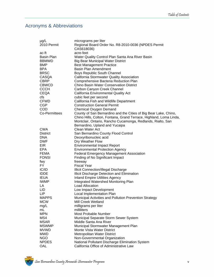
Table of Contents
San Bernardino County Areawide Stormwater Program v
Acronyms & Abbreviations
µg/L micrograms per liter 2010 Permit Regional Board Order No. R8-2010-0036 (NPDES Permit
CAS618036) ac-ft acre-feet Basin Plan Water Quality Control Plan Santa Ana River Basin BBMWD Big Bear Municipal Water District BMP Best Management Practice BPA Basin Plan Amendment BRSC Boys Republic South Channel CASQA California Stormwater Quality Association CBRP Comprehensive Bacteria Reduction Plan CBWCD Chino Basin Water Conservation District CCCH Carbon Canyon Creek Channel CEQA California Environmental Quality Act cfs cubic feet per second CFWD California Fish and Wildlife Department CGP Construction General Permit COD Chemical Oxygen Demand Co-Permittees County of San Bernardino and the Cities of Big Bear Lake, Chino,
Chino Hills, Colton, Fontana, Grand Terrace, Highland, Loma Linda, Montclair, Ontario, Rancho Cucamonga, Redlands, Rialto, San Bernardino, Upland and Yucaipa
CWA Clean Water Act District San Bernardino County Flood Control DNA Deoxyribonucleic acid DWF Dry Weather Flow EIR Environmental Impact Report EPA Environmental Protection Agency FEMA Federal Emergency Management Association FONSI Finding of No Significant Impact fwy freeway FY Fiscal Year IC/ID Illicit Connection/Illegal Discharge IDDE Illicit Discharge Detection and Elimination IEUA Inland Empire Utilities Agency IWMP Integrated Watershed Monitoring Plan LA Load Allocation LID Low Impact Development LIP Local Implementation Plan MAPPS Municipal Activities and Pollution Prevention Strategy MCW Mill Creek Wetland mg/L milligrams per liter mL milliliters MPN Most Probable Number MS4 Municipal Separate Storm Sewer System MSAR Middle Santa Ana River MSWMP Municipal Stormwater Management Plan MVWD Monte Vista Water District MWD Metropolitan Water District NGO Non-Governmental Organization NPDES National Pollutant Discharge Elimination System OAL California Office of Administrative Law

Table of Contents
vi San Bernardino County Stormwater Program
OWOW One Water One Watershed Initiative PCBs polychlorinated biphenyls PEO Public Education and Outreach Permittees Co-Permittees and the Principal Permittee POTW Publicly-Owned Treatment Works Principal Permittee San Bernardino County Flood Control District Program San Bernardino County MS4 Program QAPP Quality Assurance Project Plan QSD Qualified SWPPP Developer QSP Qualified SWPPP Practitioner REC-1 Water Contact Recreation REC-2 Non-contact Water Recreation Regional Board Santa Ana Regional Water Quality Control Board RMA Reduced Maintenance Area RMP Regional Monitoring Plan ROWD Report of Waste Discharge SAWPA Santa Ana Watershed Project Authority SMC Stormwater Monitoring Coalition State Water Board State Water Resources Control Board SWPPP Stormwater Pollution Prevention Plan SWQSTF Stormwater Quality Standards Task Force TIN total inorganic nitrogen TMDL Total Maximum Daily Load TSS Total Suspended Solids USACE U.S. Army Corps of Engineers WAP Watershed Action Plan WLA Wasteload Allocation WQMP Water Quality Management Plan

San Bernardino County Areawide Stormwater Program
ES-1
Executive Summary
On January 29, 2010 the Santa Ana Regional Water Quality Control Board (Regional Board) adopted Order No. R8-2010-0036 (NPDES Permit CAS618036), the area-wide Municipal Separate Storm Sewer System (MS4) Permit for the Santa Ana Region of San Bernardino County. This Order was the fourth permit issued to the Permit Area since 1990 and it expires on January 29, 2015. The purpose of this document is to comply with the requirement for submittal of a “Report of Waste Discharge” (ROWD) and discuss the Permittees’ Fourth Term MS4 Permit compliance activities and accomplishments over the period January 2010 to June 2014. The ROWD is an application for renewal of this Order for the San Bernardino County MS4 Program, which is comprised of the San Bernardino County Flood Control District (District), the County of San Bernardino (County), and the sixteen incorporated cities of San Bernardino County within the Santa Ana Region (collectively referred to hereinafter as the “Permittees”).
Through the development of this ROWD, the Program has looked at the bigger picture to review Permittee accomplishments and develop priorities for the San Bernardino County watershed area. This document presents the San Bernardino County MS4 Program (Program), as a mature 25-year old program, which has evolved from the program development stage (requiring extensive documentation and plan preparation associated with procedural compliance) to the implementation of projects and programs to address specific water quality issues. Over the years, these efforts have been well documented in the Annual Reports and summarized in previous ROWDs and show evidence that the iterative Program Best Management Practice approach works well for our jurisdiction. A solid foundation having been established many years ago, the various components of the MS4 Program are bearing fruit, including the following significant accomplishments:
1. Regional Dry Weather Flow Capture – In both regional and site-specific situations, dry weather flows are captured throughout the region through the utilization of over 110 multi-use facilities. Figure ES-1 provides a visual illustration of the extent of collaboration already occurring among agencies charged with water management in the region. This information, not previously included in MS4 Permit Findings, should be extensively considered during development of the Fifth Term Permit.
2. Regional Collaboration – The Program prides itself on the level of interagency collaboration that is the norm for this region. The existing formula for collaboration works well and does not require change.
3. Recreation Use Standards Basin Plan Amendment (BPA) - The Program participated in the development and adoption of the Recreational Use Standards BPA, which has been approved by the State Water Board and Office of Administrative Law.

Executive Summary
Figure ES-1. Recharge Basin Locations throughout the Permit Area in the Santa Ana River Watershed in San Bernardino County
ES-2 San Bernardino County Stormwater Program
Executive Summary
San Bernardino County Areawide Stormwater Program ES-3
4. Bacteria Source Reduction Program – The implementation of the Comprehensive Bacteria Reduction Program (CBRP) to meet ongoing Middle Santa Ana River (MSAR) Bacterial Indicator TMDL requirements, provides an example of how Permittees have used lessons learned over almost 25 years to utilize practical approaches to reduce sources of bacteria in the MS4. The Permittees have analyzed their jurisdictional areas, developed appropriate landscaping, water use and animal waste ordinances, completed hydrologic connectivity assessments, completed site-specific bacteria source identification assessments and are in the process of documenting the significance of uncontrollable natural sources of bacteria in the MS4.
The Permittees have summarized MS4 program priorities for the next permit term in Section 2 of this report. In terms of developing these priorities, the Permittees have identified the following key issues which are essential to effective Permit and TMDL compliance implementation:
1. No Regional Permit – It is currently understood that the Regional Board is pursuing a Regional Permit for San Bernardino and Riverside Counties. The Permittees respectfully request that the Regional Board reconsider the development of a single, regional MS4 Permit. The Permittees are very concerned that the mandatory incorporation of its Program into a single regional Permit (including Riverside County) without consent will substantially impede and restrict on-going implementation activities to address high priority water quality concerns and also seriously hinder the timeliness of future implementation activities.
2. MSAR Bacterial Indicator TMDL – The Regional Board has approved the Program’s Comprehensive Bacterial Reduction Plan. Section II.L.3 of the current Permit states “Once the Regional Board approves this comprehensive plan, this Order will be amended to include the comprehensive plan as the final water quality-based effluent limit that is consistent with the WLAs (Waste Load Allocations).” The Permittees request that the Fifth Term Permit, in compliance with the current Permit, include specific language of the Regional Board’s approval of the CBRP and that the CBRP is the final water quality based effluent limit for the MSAR Bacterial Indicator TMDL.
3. Receiving Water Language - Although the Permittees have had many successes to date in addressing pollutants in urban runoff, full compliance with all Water Quality Standards has not been attained. The 2010 Permit recognized this fact, but recent court opinions suggest that liability could apply if Water Quality Standards are not immediately achieved, despite the substantial efforts of the Permittees (efforts which are discussed in this ROWD). In addressing urban runoff, the Permittees are required to manage an extraordinarily complex issue with multiple variables in sources, flows and other parameters, and with finite financial and staff resources. Accordingly, the Fifth Term Permit must contain Receiving Waters Limitation (RWL) language that fully enables the Permittees to prioritize, innovate, and make needed “course corrections” in their efforts to achieve full compliance with Permit requirements.
4. Elimination of Conflicting Permit Prohibitions - There is language in the Permit(s) which is in conflict with other sections of the Permit or with other legal and regulatory agency mandates. Providing clarity on these conflicting requirements would benefit Program implementation on several levels.
5. Regional Board as Lead Agency – Given the increased focus on regional urban runoff management activities, to advance collaborative efforts among all stakeholders, and
Executive Summary
ES-4 San Bernardino County Stormwater Program
increase the likelihood of success and timeliness of proposed urban runoff management projects, the Program asks that the Regional Board act as the lead agency when conflicting regulatory agency mandates hinder proposed Program activities.
As the Fifth Term Permit is drafted, the Permittees respectfully request that the Regional Board carefully consider the many accomplishments (as documented in Section 2) and fundamental challenges (as described in Section 3) to more effective Permit and TMDL program implementation. With continued and pro-active cooperation amongst the Permittees, Regional Board and other Regional stakeholders, the Fifth Term Permit (utilizing the current Permit as a foundation) can be drafted to be the model for effective integrated watershed management.

San Bernardino County Areawide Stormwater Program
1-1
Section 1 Introduction
On January 29, 2010 the Santa Ana Regional Water Quality Control Board (Regional Board) adopted Order No. R8-2010-0036 (NPDES Permit CAS618036), the area-wide Municipal Separate Storm Sewer System (MS4) Permit for the Santa Ana Region of San Bernardino County. This Order was the fourth permit issued to the Permit Area since 1992. This Order expires on January 29, 2015. This Report of Waste Discharge (ROWD) is an application for renewal of this Order for the San Bernardino County Flood Control District (District), County of San Bernardino, and incorporated cities of San Bernardino County within the Santa Ana Region and subject to this Order.
There comes a time when policies and implementation programs need to be looked at with a new perspective. The San Bernardino County MS4 Program (Program) is at that point. This 25-year old program has evolved from the program development stage (requiring extensive documentation and plan preparation associated with procedural compliance) to the implementation of projects and programs to address specific water quality issues. This transition has occurred because of the knowledge gained from almost 25 years of learning what urban runoff management practices truly work best in the urban environment. Over the years, these efforts have been well documented in the Annual Reports and summarized in previous ROWDs. At this stage though it is time to step back, review the accomplishments of the Permittees and realign the baseline findings for the San Bernardino County area within the Santa Ana River watershed.
This ROWD is written with a new perspective while remaining cognizant that the State Water Resources Control Board (State Water Board), Regional Board, and local agencies such as One Water One Watershed (OWOW) are looking to implement system-wide approaches that create collaboration and support a holistic view of watershed management. We are going to identify Program elements already meeting these criteria, present the efficiencies and multiple benefits of these programs, discern issues with their implementation, and identify our MS4 Program priorities for the next permit term.
It is our goal to present a solid justification that the existing permit structure and requirements are working, and that regional water quality objectives are either currently being met or that the Program is making significant strides towards compliance with objectives. This document will also redefine the current baseline conditions in the watershed including stormwater resource management, water use efficiency requirements, inspection program results and development design requirements. The need for new programs or organizational frameworks will not provide any additional water quality benefits. We are going to demonstrate that through existing statewide programs, California Environmental Quality Act (CEQA) requirements, and inter-agency collaboration, the current Permit requirements and the intent of regional and statewide goals are currently being met.

Section 1 - Introduction
1-2 San Bernardino County Areawide Stormwater Program
The Program has taken this opportunity to review the current activities and data to mindfully consider upcoming statewide regulation changes and priorities. The Permittees have been and continue to use their collective knowledge to customize the various permit required programs to effectively protect receiving water quality.
1.1 MS4 Program Overview The MS4 Program currently designates the District as the Principal Permittee. The County of San Bernardino and the Cities of Big Bear Lake, Chino, Chino Hills, Colton, Fontana, Grand Terrace, Highland, Loma Linda, Montclair, Ontario, Rancho Cucamonga, Redlands, Rialto, San Bernardino, Upland and Yucaipa are designated as Co-Permittees. These jurisdictions work cooperatively on the implementation of the MS4 Program through their collective Implementation Agreement.
The current MS4 Permit is the fourth permit issued to the Permit Area since 1990. A marked change has occurred in both the expectations and emphasis associated with each of these permits. Three distinct phases are apparent. Phase 1, which encompasses both the first and second term MS4 Permits, focused on laying the foundation for the MS4 Program to manage stormwater within the Permit Area. Activities included establishing the management framework, including essential program reporting structures, management agreements, cost-sharing arrangements, and funding mechanisms. Phase 2 began with issuance of the second permit in 1996. This phase focused on program development activities including preparing the first Municipal Stormwater Management Plan (MSWMP) and ordinances to manage urban runoff, establishing procedures for inspections, evaluating permit compliance, conducting public education and outreach activities, and initiating stormwater quality monitoring activities. This phase also included significant efforts to raise community awareness to reduce sources of pollutants in urban runoff.
Phase 3 began with the third term permit (adopted in 2002) and continued with the current permit (adopted in 2010). During this phase, the MS4 Program began a shift of emphasis from procedure-oriented activities to implementation of stormwater management practices that: (1) ensure compliance with the MSWMP, (2) evaluate the effectiveness of programs, and (3) address high priority water quality concerns, especially those related to the implementation of Total Maximum Daily Loads (TMDL). Important in this shift, especially during the current permit term, was an increased focus on applying watershed-based approaches to urban runoff management, including the incorporation of Low Impact Development (LID) and green infrastructure practices into watershed management and the implementation of on the ground investigations and projects to address specific water quality concerns.
1.2 ROWD Development Process The District developed this ROWD through a collaborative effort with its Co-Permittees. All parties met on a regular basis to develop the information presented here. This effort included taking a step back to look at multiple years of data to demonstrate that many years of program implementation is yielding positive water quality benefits. This review also provided a clear basis for the implementation priorities and recommendations contained herein.
1.3 ROWD Roadmap Section XXII.A the 2010 MS4 Permit identifies five minimum elements for inclusion in the ROWD. Table 1-1 lists these five elements and where specifically this information is provided in this document. In addition to providing the minimum required content, this ROWD also describes the evolved status of the MS4 Program after four permit terms – essentially a “State of the Program”

Section 1 - Introduction
San Bernardino County Areawide Stormwater Program 1-3
assessment. This evaluation is key to understanding the basis for program recommendations for the next permit cycle. To support the Regional Board’s review of this ROWD, following is summary of the purpose and content of each subsequent ROWD Section:
♦ Section 2 – Fifth Term MS4 Program Priorities. Identifies the Permittees’ MS4 Program implementation priorities during the next permit cycle.
♦ Section 3 – MS4 Program Challenges. Describes the challenges associated with MS4 Permit implementation and identifies where the Regional Board can work in partnership with the Permittees to ensure an even more effective program moving forward.
♦ Section 4 – MS4 Program Overview. This section provides MS4 Permit background information and updates information regarding the MS4 Permit Area and the MS4 facilities owned and operated by the Permittees.
♦ Section 5 – MS4 Program Evaluation. This section highlights key MS4 Permit implementation activities during the current permit term, characterizes water quality in the Permit Area, and evaluates MS4 Program effectiveness.
As presented in this section summary, this ROWD begins by presenting fifth term Program priorities and then discusses current and expected program challenges to meet Permit obligations. We begin with a discussion on priorities and challenges first so that during review of subsequent sections (MS4 Program Overview and Evaluation), these elements can be referred to for consideration as needed.
Table 1-1. Location of Minimum ROWD Content per Section XXII.A of the MS4 Permit
Required ROWD Element ROWD Location
A program effectiveness analysis, including the effectiveness of the overall urban and storm water runoff management program in achieving water quality standards in receiving waters
Section 5.3
Any proposed revisions to the urban and storm water runoff management program based on the findings of the program effectiveness analysis (this could be included in a revised MSWMP). Revisions to the program elements should be consistent with the risk-based approach proposed in the 2006 Report of Waste Discharge.
Section 2.3
Changes in land use and/or population including map updates Section 4.2.1
Any significant changes to the storm drain systems, outfalls, detention or retention basins or dams, and other controls including map updates of the storm drain systems.
Section 4.2.2
Any new or revised program elements and compliance schedule(s) necessary to comply with Section VI [Receiving Water Limitations] of this Order
Section 2.1.1, 2.1.2
Section 1 - Introduction
1-4 San Bernardino County Stormwater Program
This page intentionally left blank
San Bernardino County Areawide Stormwater Program
2-1
Section 2 Fifth Term MS4 Program Priorities
The Permittees have taken this opportunity to review the current activities and data to mindfully consider upcoming statewide regulation changes and priorities and how they may impact the Program. The Permittees have been and continue to use their collective knowledge to customize the various permit required programs to effectively protect receiving water quality. As this ROWD is written with a new perspective looking to system-wide approaches that create collaboration and holistic approaches to watershed management, the Permittees are focused on utilizing these existing collaborative programs in the next permit term. It should be noted that the level of collaboration among agencies within this region occurs at an intensity not found anywhere else in the State. Adding new collaboration requirements to include local water district agencies is not recommended as the existing adjudication agreements establish very detailed legal responsibilities. Moreover, the Permittees already collaborate with these agencies.
For the Program, any requirements to establish new programs, organizational frameworks, or the like will only divert what are relatively static resources from implementation projects to time spent in meetings and the production of more planning documents. Maintaining a county-specific MS4 Permit is also crucial to future implementation in order to continue to seamlessly advance current program activities. Accordingly, this section focuses on the Program’s priorities for the fifth term Permit. These priorities fall into three areas:
♦ Continue emphasis on implementation of projects and activities that target high priority water quality concerns;
♦ Maintain and, where appropriate, enhance regional collaboration; and
♦ Allow modification or refinement of specific existing Program requirements to make them more effective based on experience gained.
Given these priorities, which are discussed in more detail below, the Permittees request that the fifth term Permit recognize the existing collaboration efforts and the significant progress being made towards the management of urban runoff in the Permit Area (as documented in Section 5) and establish a permit based on these priorities. This will ensure the Program is able to continue to allocate resources to improving urban runoff quality and protecting receiving water quality.
2.1 Project Implementation The following sections describe the Program’s priority implementation projects and activities planned for the fifth permit term.
Section 2 - Fifth Term MS4 Program Priorities
2-2 San Bernardino County Areawide Stormwater Program
2.1.1 Continue MSAR Bacteria TMDL Implementation MSAR Reach 3 and several major tributaries to that reach are impaired by elevated bacteria concentrations that indicate a potential health risk for persons engaged in water contact recreation (REC-1). In 2005, the Regional Board adopted a TMDL to better regulate bacteria levels in urban and agricultural runoff that reaches local lakes and streams. This TMDL became effective in 20071. The current MS4 Permit required Permittees to submit a Comprehensive Bacteria Reduction Plan (CBRP) for implementing the TMDL under dry weather conditions. The CBRP was approved by the Regional Board in 2012 and is now being actively implemented by the Permittees that have MS4 discharges within the area subject to the TMDL (see Section 5.2.3). Like other elements of the fourth term permit, allowing CBRP implementation to continue without modification is strongly preferred. This provides the time needed to monitor and assess the current program. In 2012, the Regional Board also amended the Water Quality Control Plan for the Santa Ana River Basin (Basin Plan) to update and revise the water quality standards related to protection of water contact recreation (including the associated bacteria objectives).2 These Basin Plan revisions were subsequently approved by the State Water Board, California Office of Administrative Law (OAL) and are now awaiting final approval from the Environmental Protection Agency (EPA).3
Aggressively implementing the CBRP, in accordance with the recently revised water quality standards, is one of the highest priorities for Permittees. This continues and reinforces the commitment made when these Permittees initiated a long-term, large-scale water quality monitoring and urban source investigation program in 2007.4 Since then, thousands of samples have been tested and the resulting data used to focus subsequent remediation efforts. Attachment A of this ROWD describes the Program's planned path to compliance with Dry Weather Bacterial Indicator wasteload allocations (WLAs).
In order to effectively implement the CBRP, the Program developed an innovative risk-based scoring system to target stream segments and stormwater outfalls with the highest potential to exceed water quality standards. This existing strategy is exactly the type of program that is being proposed by the State for future programs. The scoring system includes use of state-of-the-art DNA analyses to identify bacteria sources arising from human activity that pose the greatest health threat to people recreating in the water (e.g., see Figure 3.5 as an example of this prioritization). The Permittees foremost goal is to eliminate all such sources immediately after each is identified. To date, this program has conducted a number of important assessments to identify controllable sources of bacteria (Tier 1 and Tier 2 source assessments) and evaluate dry weather flows (e.g., See Sections 5.4.1 – 5.4.4). Over time, the number of water quality samples with detectable human Bacteroides has declined (see discussion in Section 5.2.3 and Figure 5-6). These evaluation assessments will continue to form the foundation of San Bernardino County's MSAR Bacteria TMDL compliance strategy.
Another aspect to the CBRP is the integration of other program elements as part of implementation. For example, the Permittees will also continue to use their current inspection programs to minimize discharges from restaurants, food processors, kennels, stables, veterinary clinics, pet stores, dog parks and similar sources with a higher potential to contribute excess bacteria to urban runoff. More recently, results from Tier 2 source assessments in 2013 have identified a few residences adjacent 1 Resolution No. R8-2007-0046; June 29, 2007 2 Resolution No. R8-2012-0001; June 15, 2012 3 State Water Board Resolution No. 2014-0005; January 21, 2014; OAL approval, July 2, 2014 4 See Monitoring tab at http://www.sawpa.org/collaboration/projects/tmdl-taskforce/ for information on this monitoring program

Section 2 - Fifth Term MS4 Program Priorities
San Bernardino County Areawide Stormwater Program 2-3
to storm channels, who were improperly disposing large volumes of pet waste by throwing it "over the fence." Permittees have notified the property owners that they must cease such practices. More serious enforcement actions will be initiated, using the authority granted by ordinances enacted by all of the Permittees, to ensure consistent compliance where needed. The Permittees will also continue their efforts at outreach to pet owners through programs like the Residential Pet Waste Campaign.
Existing regional recharge collaboration is also a key element to this program. In many portions of the valley runoff to the Santa Ana River, under dry weather conditions, is quite limited due to the 118 recharge basins within the MS4 Permit Area (see Figure 5-2). The Permittees will continue to collaborate with the watermaster and water agencies to maximize urban runoff capture and recharge while maintaining the adjudication requirements. Historically, much of the non-storm urban runoff was nuisance flow generated by improperly maintained/operated landscape irrigation systems. The recent widespread drought, and higher water rates, has caused many homeowners to significantly reduce all landscape irrigation and therefore the amount of dry weather runoff is being reduced. The Permittees are working closely with local water supply agencies to encourage better water conservation practices.
As will be discussed in more detail below, during the next permit term, the Permittees will join with their sister MS4 agencies in adjacent counties to implement the Regional Monitoring Plan (RMP) for pathogen-indicator bacteria. This new initiative, modeled on the successful bacteria monitoring program developed for the MSAR Bacteria TMDL, will utilize weekly monitoring to provide high quality data at all of the rivers, lakes and streams where water contact recreation most commonly occurs.5 The enormous amount of time and money earmarked for this project is intended to demonstrate the Permittees unequivocal commitment to protect human health by improving water quality, not just in the MSAR watershed, but throughout the area covered by the permit.
A key element in the new RMP will be development of an objective procedure consistent with Basin Plan language for determining whether elevated bacteria levels are caused by controllable anthropogenic sources or uncontrollable natural sources. The recent Basin Plan amendments defined "uncontrollable sources" to include, but not be limited to: wildlife activity and waste, bacterial regrowth with sediment or biofilm, re-suspension from disturbed sediment, concentrations (flocks) of semi-wild waterfowl and [human] shedding during swimming. The Permittees are committed to working with Regional Board staff and colleagues in the adjacent counties to develop credible scientific tools to make this determination. It is essential to ensure available resources are targeted appropriately.
Finally, assuming that the EPA approves the pending BPA (see Section 5.3.2, Recreational Use Basin Planning Activities), the Permittees within the MSAR watershed believe that re-visiting the MSAR Bacteria TMDL should be a high priority during this next permit term. Findings from extensive source evaluation activities including dry weather flow assessments need to be considered before modifying the current program. References to obsolete provisions in the Basin Plan (e.g., fecal coliform objectives) should be deleted. In addition, requirements related to wet weather compliance should be revised to reflect the newly adopted "high flow suspension." Although the deadline for wet weather compliance is not until 2025, greater regulatory clarity is required much sooner than that in order to provide adequate lead-time to develop an appropriate implementation strategy where needed.
5 Such places are designated REC-1-Tier A; see "Table 5-REC-1-Tiers" in the amended Basin Plan.
Section 2 - Fifth Term MS4 Program Priorities
2-4 San Bernardino County Stormwater Program
Protecting human health and safety is every stormwater agency's core mission. So, naturally, most of the water quality improvement efforts by Permittees within the MSAR watershed will be focused on implementing the CBRP and meeting the TMDL WLA for E. coli bacteria. Extensive source evaluation activities will continue to identify controllable bacteria sources for mitigation, effectively improving water quality and better protecting water contact recreation in San Bernardino County.
2.1.2 Continue Big Bear Lake Nutrient TMDL Implementation In 2006, the Regional Board approved a Nutrient TMDL for Big Bear Lake.6 This TMDL establishes a WLA for urban runoff of not more than 475 lbs/yr of total phosphorous during dry hydrological conditions.7 The City of Big Bear Lake, the County of San Bernardino and the District must achieve compliance with the urban WLA by December 31, 2015. It is crucial to understand that Big Bear Municipal Water District (BBMWD), who is not named in the TMDL, is the only entity with legal authority to implement mitigation activities within Big Bear Lake. This agency’s cooperation is vital for project implementation.
Since the WLA was set equal to the estimated existing phosphorus load from urban runoff during dry hydrological conditions, the TMDL does not require the Permittees to reduce these loads. However, the current MS4 Permit does specify that the "Big Bear Lake Permittees shall implement BMPs in the watershed so as not to exceed the urban WLA for phosphorus."8 This demonstration is to be made using a watershed model approved by the Regional Board.9
In 2013, the Permittees worked closely with Regional Board staff to review and update the existing watershed model. Phosphorus loads from all sources are recalculated each year and an annual report is submitted to the Regional Board. Because of the on-going drought, it appears that the period from 2011 to 2014 will qualify as a "dry hydrological condition." However, as of the date this ROWD was prepared and submitted (July 2014), it is not clear whether the average annual phosphorus load will be greater than or less than the 475 lbs/yr allotted by the WLA for urban sources.
To assure compliance with the WLA (by December 2015), the Permittees have joined with Big Bear Municipal Water District (BBMWD) to implement a large-scale alum application to Big Bear Lake in the spring/summer of 2015. This project is expected to sequester approximately 20,000 pounds of phosphorus; more than enough to neutralize all of the urban phosphorous loading that occurred in the 8 years since the TMDL was approved by EPA (Table 2-1).10 The project is designed to ensure that urban sources are no longer causing or contributing to any future nutrient impairments in Big Bear Lake by neutralizing phosphorous loads in all but the wettest (e.g., "El Niño")11 hydrological conditions and goes well beyond the minimum requirements for compliance established by the TMDL and the current MS4 Permit (Figure 2-1). It should be noted that nearly 40% of the total funding for the planned alum application is being provided by MS4 Permittees that are not named in the TMDL. The cities located in the valley far below Big Bear Lake elected to participate voluntarily as a demonstration of this Program’s programmatic commitment to address the high priority water quality concerns.
6 R8-2006-0023 (April 26, 2006). 7 Dry hydrological conditions are similar to those that occurred in the 5-year period between 1999 and 2003. 8 NPDES No. CAS618036; §V-D-4-b 9 NPDES No. CAS618036; §V-D-4-k 10 TMDL was approved by OAL on 8/21/07 and by U.S. EPA on 9/25/07. 11 Median annual precipitation at Big Bear Dam (1990-2014) = 32" of rain; examples of extreme wet years include 1993 (74"), 2005 (55"), and 2010 (64").

Section 2 - Fifth Term MS4 Program Priorities
San Bernardino County Areawide Stormwater Program 2-5
Table 2-1. Estimated Phosphorus Loads from Urban Sources (2007-2011)
Year Precipitation (inches) Urban Load (lbs)
2007 16.1 227
2008 37.9 1,333
2009 30.7 868
2010 64.1 3,290
2011 25.2 1,632
The City of Big Bear Lake, County and the District will also continue to coordinate with BBMWD to implement the current aquatic weed control program. This successful program has already eradicated 95% of the Eurasian Water milfoil that once infested Big Bear Lake thereby ensuring attainment of the TMDL target by 2015. And, yearly surveys show that native plant species are slowly recolonizing the lake. The results of this on-going effort are summarized and reported annually to the Regional Board.
Finally, the Program will continue to coordinate with BBMWD and the local ski resorts to implement the TMDL water quality monitoring program. All data are tabulated and submitted to the Regional Board in annual reports.
Figure 2-1. Annual Precipitation at Big Bear Dam (1990-2014)
Section 2 - Fifth Term MS4 Program Priorities
2-6 San Bernardino County Stormwater Program
It should be noted that all of the above efforts are being implemented without any assistance from other dischargers named in the TMDL. Both the U.S. Forest Service and the California Department of Transportation ("Caltrans") have declined to provide any financial support to implement the TMDL. As a result, the Big Bear Lake TMDL Task Force was disbanded in the fall of 2012. Since then, the Permittees and BBMWD have assumed the full financial burden for assuring TMDL compliance.
This abdication of responsibility by other agencies is particularly troublesome considering that the U.S. Forest Service owns 85% of the watershed surrounding the lake and the total phosphorus load from the national forest is nearly 40% greater than that coming from local urban sources. If Big Bear Lake fails to achieve the numeric targets for phosphorus and chlorophyll-a, it will be due to these federal and state agencies having made no tangible effort to implement the TMDL or improve water quality in the region. The Permittees request that the Regional Board consider this total lack of commitment before imposing any additional regulatory obligations on urban stormwater management agencies.
2.1.3 Develop Regional Monitoring Program and Evaluate Existing Use Impairment Listings for Bacterial Indicators As noted in Section 2.1.1, with the adoption of the Recreation Use Standards BPA, the Stormwater Quality Standards Task Force (SWQSTF), which includes San Bernardino County’s sister stormwater agencies, is obligated to develop an RMP that prioritizes bacterial indicator sampling where REC-1 activity is most likely to occur. The BPA identifies four high priority sites within the Permit Area where year-round monitoring is to occur: Lytle Creek, Mill Creek (Reach 2), San Antonio Creek and Big Bear Lake. While additional resources will be needed to implement the monitoring anticipated by the BPA, the Program is committed to participating in this program wherever stormwater has the potential to impact water quality.
Much of the dry weather runoff from the upper watershed is infiltrated into the recharge basin system. Those remaining areas not managed through recharge are to be the focus of on-going Permittee efforts to identify controllable anthropogenic sources of bacterial indicators. Much of these efforts are required in the southwestern portion of the County where large scale infiltration is infeasible or prohibited due to the presence of poor soils and the Maximum Benefit Zone (MBZ) managed by IEUA.
Development of an objective procedure for determining whether elevated bacteria levels are caused by controllable anthropogenic sources or uncontrollable natural sources is an important element of the RMP. These procedures are especially needed given the need to properly evaluate bacterial indicator data and potential risks to human health. This is particularly important because new data now show that several waterbodies previously cited for excessive bacteria concentrations may no longer be impaired12. And, other waterbodies are moving closer to meeting applicable water quality standards. The Permittees will work closely with Regional Board staff to prepare the documentation needed to remove these waterbodies from the state's 303(d) list during the review cycle scheduled to occur in 2016. Permittees will also intensify water quality monitoring efforts where needed to determine if elevated bacteria levels are the result of anthropogenic activity. This effort may include implementation of studies, either under the Program or the MSAR Bacteria TMDL Task Force, to better understand the contribution of bacterial indicators from uncontrollable sources.
12 Per Bill Rice of the Regional Board, as note discussed at the joint Stormwater Quality Standards and MSAR Task Force meeting on April 15, 2014
Section 2 - Fifth Term MS4 Program Priorities
San Bernardino County Areawide Stormwater Program 2-7
2.1.4 Support Integrated Water Resource Management Projects Section 5.3.4 described a number of ongoing or completed water resource projects within the area that will provide multiple benefits to the region. These benefits include protection of downstream waters (through stormwater capture, such as the Mill Creek Wetlands), increased local water supply (through infiltration of captured stormwater, such as Cucamonga Basin #6), habitat or channel restoration, and increased habitat for wildlife. As noted previously, over 110 basins have been constructed, or modified, to operate as a groundwater recharge facilities in the area covered by the Permit, with the potential for additional facilities to be brought on-line in the future. Interestingly, many places in the United States are just now beginning to consider the benefits of integrated water resource planning; and, as a consequence, the number of multi-benefit water resource projects is on the rise in many places. This change is driven by a number of factors, including the recognition that effective water resource management is best accomplished in a holistic manner, as well as the need for water/wastewater/flood control agencies to pool resources to achieve their goals. The County figured out the benefits of this approach a long time ago. And, with California in a drought emergency, the importance of developing more of these projects has been elevated even more.
In the next permit term, the Program will continue its ongoing efforts to aggressively seek opportunities to collaborate on water resource projects that provide multiple benefits to the area, including mitigating dry weather runoff and stormwater quality concerns. The Permittees are already partnering with the water districts to capture urban dry weather runoff. Other potential partners include environmental and regulatory agencies (e.g., U.S. Forest Services, U.S. Fish & Wildlife Service, Bureau of Reclamation, California Fish and Wildlife Department [CFWD]), and neighboring MS4 Programs and flood control districts. This commitment to integrated water resource management is consistent with the Santa Ana Watershed Project Authority (SAWPA)-led OWOW initiative for the watershed and the response required to the recently declared State of California Drought Emergency.
Integrated water resource management projects are developed and implemented over long time frames (often well beyond a single permit term) to allow for all planning and public outreach requirements to be met (e.g., CEQA) and for jurisdictions to secure required funding. As a consequence, for Permittees to participate in these projects they need to be able to commit to providing funding to projects that provide multiple benefits (beyond stormwater quality) well in advance of the project. The new MS4 Permit must allow for participation in these projects by developing permit language whereby the Permittees have the flexibility to focus program resources on these efforts where they will provide important urban runoff quality benefits.
Lastly, one of the key lessons learned with regards to making integrated water project plans a reality, is the need for resource agency participation and acceptance. The Permittees are requesting that in this next Permit term when the Program seeks to pursue a Regional or Sub-regional BMP Project, that the Regional Board act as lead agency for regulatory permitting tasks. In addition, the fifth term Permit needs to contain language to encourage the U.S. Army Corps of Engineers (USACE), California Department of Fish & Wildlife, Bureau of Land Management, and others to participate in such a way so that regulatory decisions are timely and proactive for the proposed projects. Additional language is required stating that the Permittees are not held responsible for the inaction or delayed responses from the other regulatory agencies when their concurrence is necessary or when they have a competing or contradictory regulatory mandate.

Section 2 - Fifth Term MS4 Program Priorities
2-8 San Bernardino County Stormwater Program
2.1.5 Apply EPA's Integrated Planning Framework to Prioritize Project Development The EPA finalized its Integrated Municipal Stormwater and Wastewater Planning Approach Framework (“Integrated Planning Framework”) in its June 5, 2012 memorandum to EPA Regional Administrators and Regional Permit and Enforcement Division Directors. While the framework is intended to combine stormwater and wastewater planning activities, the planning framework is sound even if just applied to stormwater programs. As stated by EPA:
“Integrated planning will assist municipalities on their critical paths to achieving the human health and water quality objectives of the CWA [Clean Water Act] by identifying efficiencies in implementing requirements that arise from distinct wastewater and stormwater programs, including how best to make capital investments. Integrated planning can also facilitate the use of sustainable and comprehensive solutions, including green infrastructure, that protect human health, improve water quality, manage stormwater as a resource, and support other economic benefits and quality of life attributes that enhance the vitality of communities.”
According to the EPA, some of the key overarching principles associated with the development of an integrated plan include:
♦ Maintain existing regulatory standards that protect public health and water quality.
♦ Allow a municipality to balance CWA requirements in a manner that addresses the most pressing public health and environmental protection issues first.
♦ Innovative technologies, including green infrastructure, are important tools that can generate many benefits, and may be fundamental aspects of a municipality’s plans for integrated solutions.
The purpose and principles described above recognize the benefits of prioritizing available capital and emphasize the value in prioritizing resources to address the highest priority environmental concerns first given resource limitations. This approach should be applied to the Program. This does not mean that some water quality concerns will not be addressed; it only means that prioritizing projects is a valid approach to environmental protection.
As discussed above, the increased emphasis on integrated water resource management in the region, which targets multiple water issues and accordingly provides multiple benefits, means that the opportunity exists for stormwater programs to contribute resources to larger, diverse projects to include stormwater quality benefits. But you have to have the resources to be able to participate in such projects. In the next permit term, the Permittees request that the Regional Board issue an MS4 Permit that allows for funding opportunities, for example through grant programs. The language in the permit needs to be presented so that Permittees are not discouraged to apply for these programs.
2.2 Continued Regional Collaboration One of the keys to progress in stormwater management over several permit terms and in particular in the last decade has been regional collaboration among stormwater agencies and between the Program and the Regional Board or other dischargers or water agencies in the region. This collaboration has developed naturally as benefits of shared goals, resources, and knowledge become more apparent. During the fifth permit term, the Program will not only maintain this
Section 2 - Fifth Term MS4 Program Priorities
San Bernardino County Areawide Stormwater Program 2-9
collaborative approach but seek opportunities to further enhance collaboration. Following is a brief overview where regional collaboration opportunities continue to exist.
2.2.1 Santa Ana Region County MS4 Programs The Program has been collaborating with the Orange County and Riverside County MS4 Programs for many years. Some of this collaboration regularly occurs behind the scenes, through sharing of program experiences and knowledge. Other activities are highly visible, such as the work of the regional Task Forces administered by SAWPA, but funded in part by the Permittees (e.g., MSAR Bacteria TMDL and Stormwater Quality Standards Task Forces). In addition, the Program was an active participant in the OWOW initiative, which is guiding the types of integrated water resource management projects described above in Section 2.1.4 and illustrated by example projects in Section 5.4. During the fifth MS4 Permit term the Program will maintain this collaboration with other County MS4 Programs and continue to contribute funding to Task Force activities.
2.2.2 Regional Board The Program currently collaborates with the Regional Board through participation on two regional Task Forces (MSAR Bacteria TMDL and Stormwater Quality Standards Task Forces) and previously also collaborated on the Big Bear Lake Nutrient TMDL Task Force. Participation on these Task Forces provides the opportunity for the Permittees and Regional Board staff to share their views openly and identify approvable approaches to address high priority water quality concerns. During the next permit term, the Program will continue its participation in and funding support of the MSAR Bacteria TMDL and Stormwater Quality Standards Task Forces. In addition, the Program will work collaboratively with the Regional Board on the implementation of the Regional Monitoring Program that is being developed to support the adopted Recreational Use Standards BPA.
2.2.3 Other Agency Collaboration The Permittees already regularly collaborate with other agencies, e.g., water purveyors, Publicly-owned Treatment Works (POTW) dischargers, and agricultural interests, to coordinate stormwater management activities and TMDL implementation requirements in the region. Some of this collaboration occurs between individual Permittees and local agencies, but other collaboration, such as with the agricultural community, also occurs through the work of the MSAR Bacteria TMDL Task Force.
Collaborative activities are already occurring with agencies involved in water management, as evident by several of the project activities presented in Section 5.4, and explained in earlier sections. Increased emphasis on integrated water resource management in the region is required through many regulatory venues. In the next permit term, the language used in the MS4 Permit must be cognizant of the existing watershed adjudication judgments and flexible for collaborative implementation.
2.3 Proposed Modifications or Refinements to Existing MS4 Permit Requirements As discussed in Section 2.1, the Program’s priority for the fifth term MS4 Permit is continued implementation of existing Program activities that focus on the high priority water quality concerns within in the area under the jurisdiction of the permit. For the most part this can be done through continued application of current MS4 Permit requirements and procedures. However, the Permittees have identified a few areas where modifications or refinements to existing MS4 Permit requirements
Section 2 - Fifth Term MS4 Program Priorities
2-10 San Bernardino County Stormwater Program
would make the overall program more effective at addressing its priorities. These requests, which are summarized below, are based on the significant experience gained through permit implementation.
2.3.1 Receiving Water Limitations Permit Language The 2010 MS4 Permit establishes the legal obligation to protect water quality and rigorous implementation procedures by which dischargers can demonstrate compliance. This approach has worked well because it sets high standards for performance but recognizes that meeting these standards will require considerable time and resources. Thus, the process is deliberately designed to reward good faith efforts to implement BMPs that are designed to achieve reasonable progress toward attainment. Historically, the obligation and the process were always seen as two sides of the same coin and permit compliance was measured by evaluating both effort and results together. Failure was not a crime, failing to try (or try again) was.
Recent judicial decisions have undermined this long-standing approach to improving water quality in urban runoff. The Ninth Circuit Court has held that compliance with any receiving water limitations must be determined without regard to other provisions of the permit that set forth the iterative implementation process. The court's interpretation is contrary to decades of prior practice and is inconsistent with all federal and state guidance on the issue.
Existing MS4 Permits in the region are long and complex documents that are meant to be read "as a whole." The court misinterpreted the receiving water limitations because there was no explicit language in this particular section of the permit that described the multi-faceted evaluation used to judge interim compliance based on the iterative and adaptive implementation procedures specified elsewhere in the permit. It is essential that the next permit be revised to make this connection absolutely clear.
Numerous examples are available to guide the Regional Board as it drafts the new permit. EPA has issued similar permits elsewhere in the country (e.g., District of Columbia) that can serve as a template for the Santa Ana Region. California Stormwater Quality Association (CASQA) has prepared similar template language that should be considered.
By clarifying the current permit language, the Regional Board is not modifying the obligation or revising the process. It is merely stating in unambiguous terms that which was always intended. To that end, the receiving water limitations permit language must also include specific provisions which state that Permittees can be deemed in interim compliance with these limitation provided they: (1) have an approved long-term plan to meet water quality standards; (2) are making a good faith effort to fully implement that plan; (3) are evaluating the effectiveness of those efforts; and (4) are making reasonable progress toward attaining water quality standards. It is exactly the same approach that is already used in the CBRP to produce significant real-world improvements in water quality.
2.3.2 Inspection Responsibilities and Liabilities The MS4 Permit requires the Permittees to perform on-site inspections to assess the effectiveness of BMPs built to control stormwater runoff from construction sites. There are two challenges with this requirement: (1) there are projects that the Permittees have no jurisdictional authority over such as schools, hospitals; and (2) as designated in the Construction General Permit (CGP), the Professional Engineer of record, as the Qualified SWPPP Developer (QSD) and Qualified SWPPP Practitioner (QSP) are the legally designated person(s) with the technical knowledge for on-site BMP construction and implementation, and for determining their effectiveness.

Section 2 - Fifth Term MS4 Program Priorities
San Bernardino County Areawide Stormwater Program 2-11
Concerning Issue 1, per Finding I.B of the MS4 Permit, the Permittees have no legal jurisdiction over stormwater discharges from specific types of sites:
“The Permittees lack legal jurisdiction over storm water discharges into their systems from State and federal facilities, e.g., schools and hospitals, utilities and special districts, Native American tribal lands, wastewater management agencies and other point and non-point source discharges otherwise permitted by the Regional Board. The Regional Board recognizes that the Permittees should not be held responsible for such facilities and/or discharges.”
Without legal jurisdictional over the sites described above, it is inappropriate for Permittees to make any findings regarding adequacy of required stormwater controls on these sites. The Permittees can verify permit coverage for the site, inspect the site to verify that BMPs to control runoff from the site to the MS4 are properly constructed, but they do not have the authority to make any findings regarding the adequacy of on-site BMP controls. They also cannot accept the liability associated with making such findings. The Permittees request that the Regional Board work with the Permittees to modify Permit language where necessary to remove any potential responsibility or liability regarding adequacy of on-site BMP controls where the Permittees lack legal jurisdiction. This revised Permit language should clarify that Regional Board staff have the responsibility to conduct on-site inspections.
Issue 2 is explained through the CGP. As presented in the CGP Appendix 5 Glossary, the QSP is the:
“Individual assigned responsibility for non-storm water and storm water visual observations, sampling and analysis, and responsibility to ensure full compliance with the permit and implementation of all elements of the SWPPP, including the preparation of the annual compliance evaluation and the elimination of all unauthorized discharges.”
The QSD, as a licensed professional engineer, holds the responsibility for site design, grading and off-site connections. The QSD is the appropriate entity to verify that a project’s BMP effectiveness is adequate. The fourth term Permit requires the MS4 Permittee to essentially usurp the authority of the person legally designated in the CGP as having responsibility for these actions. This element should be revised to require the MS4 Permittee to have responsibility only for “illicit discharges” from those construction sites having valid coverage under the CGP.
2.3.3 Increase Certification of BMP Functionality from Three to Five Years MS4 Permit Section XI.H.4 requires that BMPs built per the approved Water Quality Management Plan (WQMP) or other conditions of approval be certified as fully functional prior to issuance of a Certificate of Occupancy. Following this certification, the BMP is to be inspected again within three years of project completion and every three years after to verify that the BMP is being properly maintained, operated and functional.
The Permittees request that the fifth term Permit modify the period between post-construction BMP inspections from three to five years. With the number of BMPs requiring inspection rapidly increasing with implementation of the new WQMP requirements, this change will provide the opportunity for better allocation of resources. It is most important for resources to be allocated at the front end of the process to verify that BMPs are properly installed during project construction.
Section 2 - Fifth Term MS4 Program Priorities
2-12 San Bernardino County Stormwater Program
In addition, the Permittees request that the permit be modified such that the required certification and subsequent inspection activities not be limited to Permittee staff. Third party or self-inspection and certification should be an acceptable means to demonstrate compliance with this specific permit requirement.
2.3.4 Promote Regional BMP Opportunities Section 2.1.4 of this ROWD describes the importance of integrated water resources management to the region. While supportive of efforts to comply with TMDL WLAs and other water quality issues of concern, integrated water resources management is critical to the well-being of the region given increased pressure on water supplies and drought concerns.
With continued development in the region, the opportunity for development of regional or sub-regional BMP projects to manage urban runoff will increase. Moreover, where such BMP projects can be closely linked with other regional efforts to more effectively manage water resources, opportunities for partnerships among water agencies should be encouraged.
The 2010 MS4 Permit established the following LID BMP hierarchy: Infiltration, harvest and reuse, bioretention and biotreatment. An evaluation of the feasibility of implementing these LID BMPs on-site is required before an alternative compliance approach may be considered, e.g., reliance on a regional BMP. This hierarchy establishes significant barriers to the implementation of regional or sub-regional BMP projects. Given the regional need to manage water use more effectively and the desire among many regional water purveyors, POTWs, planning agencies, and others to focus resources on the development of multi-benefit projects, it is critical that where opportunities become available to use urban runoff as a resource to support an integrated water resource project that the MS4 Permit not become a barrier to such participation.
The recently adopted Los Angeles County Permit established performance criteria that may be applied to a project where there is an opportunity for regional groundwater replenishment off-site from the development13. This permit language supports opportunities to manage local water resources more effectively. In addition, the draft Orange County MS4 Permit allows for the use of off-site LID BMPs where appropriate demonstrations are satisfied. The Permittees request similar flexibility in the next MS4 Permit. When projects are being developed and opportunities exist to support an integrated water resource project, the MS4 Permit should not become a barrier to an environmentally beneficial outcome. The Permittees also request a clear definition of receiving water (include conveyance system into the language for regional treatment BMPs) language.
2.3.5 Modify Training Requirements from Annual to Biannual MS4 Permit Section XVI.D states that the Principal Permittees shall provide training on the Municipal Activities and Pollution Prevention Strategy (MAPPs) on at least an annual basis. In addition, Section XVI.H states that all staff involved with stormwater related projects and the implementation of the permit shall provide training on an annual basis, prior to the rainy season. This training frequency is resource intensive and with the exception for where training is needed for new staff, the Program processes and procedures do not change at a high enough frequency to warrant required annual trainings. Moreover, given that the high level permit implementation requirements change no less than once every five years, repeating this information on an annual basis does not provides limited benefit for the resources incurred.
13 Los Angeles Regional Water Quality Control Board Resolution R4-2012-0175; http://www.swrcb.ca.gov/rwqcb4/water_issues/programs/stormwater/municipal/index.shtml
Section 2 - Fifth Term MS4 Program Priorities
San Bernardino County Areawide Stormwater Program 2-13
The Permittees request that the fifth term Permit provide the opportunity to prepare and submit for approval an alternative training requirement schedule that considers how the frequency of training may vary depending factors such as: (a) training needs for new staff; (b) training for existing staff, especially staff with multiple years of service; (c) special trainings that focus specifically on new implementation requirements that result from completion of permit deliverables that result in a change to an important Program area or MSWMP.
2.3.6 Conflicting Permit Prohibitions As presented throughout this ROWD, the fifth term Permit should be focused on implementation. As with any long-term project or program, it is at the time of implementation when conflicting needs, requirements, or facts must be prioritized and managed. The Program team has carefully analyzed a number of conflicts; and the outcomes are as follows:
Receiving Water Language: Although the intent of the “Waters of the US” and Statewide “Receiving Waters” regulatory language is understandable, it creates conflict for implementation and increased liabilities. The definition of “Waters of the US” and “Receiving Waters” changes what is an MS4-only facility.
♦ Clarification is needed regarding the prohibition in the Permit concerning discharge of pollutants to receiving waters, especially in light of the recently revised “Waters of the US” designation criteria. The fundamental concept of a NPDES Permit is to permit allowable discharges under specified conditions.
♦ Clarification is requested concerning the prohibition to discharge waste to, or use as a means of conveyance of pollutants to a regional BMP, a Water of the US, and, at the same time, have the Permit require development of regional BMPs (WAP retrofit sites) as alternate compliance.
Regulatory Agency conflicts: There are multiple conflicting regulatory mandates between resource agencies. The Program has already encountered, especially during Environmental Impact Report (EIR) preparation and permitting phases, a disconnect among the resource agencies. Fish and Wildlife mandates in particular need to be addressed at a higher level. This may require direct collaboration between the Regional Board and Fish and Wildlife in advance of any proposed regional BMP approvals. Clear Permit language stating that the Regional Board will take the lead on regional resource agency collaboration sets the tone for true regional watershed management.
EIR requirements: Although Regional Board permitting actions are exempted from CEQA, many of the required implementation projects are not. The Program requests a statement in the Permit findings that recognizes the schedule, funding and CEQA requirements when processing a project. It is possible that, through the CEQA process, project approvals can be held up and, due to CEQA process or mitigation costs, stopped. Stating that the typical timeframes for the CEQA process approvals are understood clarifies possible project implementation schedule conflicts.
Section 2 - Fifth Term MS4 Program Priorities
2-14 San Bernardino County Stormwater Program
This page intentionally left blank

San Bernardino County Areawide Stormwater Program
3-1
Section 3 MS4 Program Challenges
3.1 Conflicting Mandates and Uses Increasingly, conflicts exist between the intended use of drainage facilities and regulatory mandates or approvals that impact the ability of stormwater managers to manage those facilities as intended or as required by the Permit to achieve compliance with the Permit. For example, while stormwater channels may have been originally designed for the purpose of moving water during high flow events to protect life and property, these channels also often serve water management functions unrelated to stormwater conveyance. These non-stormwater related functions include among others water transfers, management of rising groundwater, and conveying water from fire hydrant testing and well blow-offs.
Nearly all of the non-stormwater related activities described above are governed by the Regional Board's General Order authorizing certain De Minimus discharges1. Although these discharges may exhibit acceptable water quality at the point of discharge, they can create conditions that cause downstream pollution. This is especially true for stimulating bacteria growth and/or mobilizing nutrients in the sediment. Since the Regional Board has determined that such discharges pose no significant threat to water quality, MS4 agencies should not be held legally responsible where such flows may cause or contribute to downstream exceedances. Without such liability protection, the Permittees have no choice but to prohibit all such discharges to the MS4 system in the future. Alternatively, the Regional Board can require all De Minimus dischargers to demonstrate that the discharge will have no adverse effect on water quality at the point of discharge and at all locations downstream of that point as a condition of enrollment under the General Order.
Another critical area where implementing solutions to mitigate a water quality problem can conflict with opposing regulatory mandates is the increasing challenge for stormwater managers to modify or retrofit existing MS4 facilities. For example, MSAR Bacterial Indicator TMDL source evaluation studies have repeatedly shown that Chris Basin at the lower end of Deer Creek in the Cucamonga Creek subwatershed should be targeted for a basin retrofit project to improve water quality prior to the basin’s discharge to Cucamonga Creek (e.g., see T1-CHRIS listed as a high priority in Figure 5-5).
The District has developed a plan to modify the flow through Chris Basin from a straight-line (inlet to outlet) flow to a meandering flow. The proposed “modification” of flow line does not change the bottom elevation of the basin, nor reconfigure the toe or side slopes. The purpose of the modification is simply to create windrows that force the dry weather flow to traverse the basin floor in a back and forth manner, slowing flow and allowing for degradation of bacteria before discharge to Cucamonga Creek (Figure 3-1).
1 Resolution R8-2009-0003

Section 3 - MS4 Program Challenges
3-2 San Bernardino County Areawide Stormwater Program
The entire size of the basin “floor” area is 5.5 acres. This project would provide significant benefits to downstream water quality.2,3
To date, the project remains conceptual because of the significant regulatory mandates that must be satisfied to make a change in the configuration of a basin that was built for the purpose of managing flood waters in the drainage area. Over the years, vegetation has developed in the basin and many other regulatory agencies must decide the “value” of the project per their mandates and requirements to protect this “habitat”. The regulatory hurdles that must be cleared are substantial – any of which has the potential to delay or even stop a project identified as necessary to manage water quality and comply with the MSAR Bacterial Indicator TMDL. These impediments include
♦ 1602 Streambed Alteration Agreement (CDFW)
♦ 401 Certification (Regional Board)
♦ 404 Nationwide Permit 31 for maintenance activities (USACE)
♦ CEQA clearance,
♦ Biological surveys and reports
♦ Cultural surveys and reports
♦ Air and Noise studies and reports
♦ Jurisdictional delineation
♦ Mitigation proposal (on-site, off-site, in-lieu fee) and potentially a Mitigation Management Plan
♦ Nesting bird/burrowing owl plan, if needed
♦ Maintenance Baseline Study (USACE)
It is understood that other agencies are obligated to meet their contractual or regulatory mandates. However, it is incumbent for the Regional Board to recognize that non-compliance resulting from the imposition of obligations or requirements by another agency that impacts the utility of a water quality mitigation project or impacts downstream water quality does not result in non-compliance with the
2 MSAR Final Triennial Report, February - 2013: http://www.sawpa.org/wp-content/uploads/2013/01/CBRP-TMDL-Implementation_Final.pdf 3 Final Technical Memorandum–Dry Weather Runoff Controllability Assessment for Subwatershed (Chris Basin): http://sawpa.org/documents/ChrisBasinTM_revised_060910.pdf
Figure 3-1. Existing Chris Basin Configuration
Section 3 - MS4 Program Challenges
San Bernardino County Areawide Stormwater Program 3-3
Permit - especially when the Permittees have made a good faith effort to plan and mitigate the cause of the water quality concern. To avoid this type of conflict when developing project plans, the Permittees are requesting that the Regional Board serve in a lead agency role for these projects at least through the permitting phase. This support would streamline the project approval process so that already limited project funds can be used for direct implementation rather than support of lengthy legal/process-related activities.
3.2 Finite Economic Resources The allocation of financial resources to support stormwater management activities occurs at the elected official level not at the Program level. Elected officials have many priorities; therefore, within each MS4 jurisdiction the availability of resources in a given fiscal year is finite. Given this reality, the Permittees can do well a limited number of urban runoff management projects that target the highest priority water quality concerns, or they can spread out the annual budget made available to them to address new programmatic activities that do little to actually mitigate water quality concerns. Over the past decade, and especially over the last five years, the Program has shifted its focus to the highest priority water quality issues (i.e., Big Bear Lake nutrients and MSAR watershed bacteria) and dedicated significant resources to solving these problems. The Regional Board and State Water Board have demonstrated their agreement with these priorities by approving grant awards to provide seed money to ensure projects move from conceptual drawing board to reality.
Moving forward, the Permittees request a Permit that understands that there will always be multiple water quality priorities within the permit area, but the top priorities will be addressed first. This risk-based approach allocates resources to the most important water quality concerns. It is also consistent with EPA’s Integrated Planning Framework that recognizes that individual agencies are faced with increased competition for the finite dollars available to their area (see Section 2.1.5). This Program is already effectively implementing EPA’s approach to water management. We request that the fifth term Permit not create barriers to continued implementation of this risk-based approach.
3.3 Barriers to Integrated/Regional Approaches to Stormwater Management California is in the midst of a water supply crisis because of extended drought. Regardless of how long the drought continues, agencies that have water management responsibilities, including stormwater agencies, need to work together to ensure local water supplies remain viable. One of the keys to enhancing local supply is through capture and infiltration of urban runoff. As described in Section 5.2.2 and Section 2.1.4, the Santa Ana Region of San Bernardino County has invested heavily in the capture and recharge of urban runoff. It is because of these efforts that many potential impacts to downstream receiving waters from pollutants in urban runoff are being mitigated before they reach these downstream waters.
Section 2.3.4 of this ROWD identified an important issue with regards to how the 2010 Permit limits the opportunity for the Permittees to participate in regional projects where water can be captured and infiltrated to recharge groundwater. The Permittees have requested that this permit language be modified to remove this barrier to effective regional water management. In addition, the fifth term Permit should be carefully crafted to ensure that no other barriers to holistic water management be purposefully incorporated or result from unintended consequences of new permit language. In that regard, any new permit language being considered by the Regional Board should be carefully vetted to ensure that the permit language promotes, rather than hinders, the use of urban runoff as a local or regional water resource.
Section 3 - MS4 Program Challenges
3-4 San Bernardino County Stormwater Program
This page intentionally left blank
San Bernardino County Areawide Stormwater Program
4-1
Section 4 MS4 Program Overview
4.1 MS4 Permit Background The Santa Ana Region within San Bernardino County has been authorized to discharge stormwater since 1990 under four separate MS4 Permits. Following is a brief summary of each of these permits and their primary focus.
4.1.1 Permit History On August 29, 1990, the Regional Board adopted the first term Riverside County NPDES MS4 Permit, Order No. 90-136 (NPDES No. CAS8000200). This permit included the District as the Principal Permittee and the County of San Bernardino and the Cities of Big Bear Lake, Chino, Chino Hills, Colton, Fontana, Grand Terrace, Highland, Loma Linda, Montclair, Ontario, Rancho Cucamonga, Redlands, Rialto, San Bernardino, Upland and Yucaipa as Co-Permittees.
The Regional Board issued the second term MS4 Permit (Order No. 96-32; NPDES No. CAS618036) for the Permit Area in March 1996. Both the first and second term MS4 Permits focused on laying the foundation for the Program to manage stormwater within the permit area. Activities ranged from establishing the governance agreements for the Permittees to work collectively on stormwater management to developing the first MSWMP and establishing ordinances so that dischargers had the authority to implement permit requirements within their respective jurisdictions. These early years emphasized procedures and documentation – providing a foundation for the development and implementation of the new regulatory program.
The Regional Board adopted the third and fourth-term MS4 Permits on April 26, 2002 (Order No. R8-2002-0012; NPDES No. CAS618036) and January 29, 2010 (Order No. R8-2010- 0036; NPDES No. CAS618036), respectively. These permits shifted the Program emphasis from generally passive procedures and document preparation approach to an active approach that focused on implementation of projects to address high priority water quality concerns and better manage urban runoff on site. This active approach ensures that finite Program resources are directed to where they can be most effective in improving runoff quality and protecting receiving waters.
4.1.2 MS4 Permittees Table 4-1 presents the contact information for the Permittees that are subject to this ROWD. The table provides contact information for both the primary contact and an alternate contact, where one has been designated.
4.2 MS4 Characterization The following sections provide an update to the area covered by this ROWD, including population changes over time, MS4 facility characteristics and an evaluation of available program resources based on long term trends in annual expenditures.

Section 4 - MS4 Program Overview
Table 4-1. MS4 Permittee Contact Information
Permittee Coordinator Alternate
City of Big Bear Lake P.O. Box 10000 Big Bear Lake, CA 92315
Joe Cylwik [email protected] 909-866-5831, ext. 127
David Lawrence [email protected] 909-866-5831, ext. 198
City of Chino 13220 Central Ave Chino, CA 91710
Ruben Valdez [email protected] 909-464-0744
Jesus Plasencia [email protected] 909-464-0781
City of Chino Hills 15091 La Palma Avenue Chino, CA 91710
Tad Garrety [email protected] 909-364-2722
---
City of Colton 303 East “E” Street Colton, CA 92324
Reggie Torres [email protected] 909-370-6128
Victor Ortiz [email protected] 909-370-5065
City of Fontana 17005 Upland Avenue Fontana, CA 92335
Dan Chadwick [email protected] 909-350-6798
Tony Mata [email protected] 909-350-6772 Tanya Honeycutt [email protected] 909-428-8819
City of Grand Terrace 22795 Barton Road Grand Terrace, CA 92313
Matt Wirz [email protected] 909-430-2217
---
City of Highland 27215 East Base Line Highland, CA 92346
Melissa Morgan [email protected] 909-864-8732, ext. 230 Andrea Saavedra [email protected] 909-864-8732, ext. 371
Carlos Zamano [email protected] 909-864-8732, ext. 254
City of Loma Linda 25541 Barton Rd. Loma Linda, CA 92354
Jeff Peterson [email protected] 909-799-4407
T. Jarb Thaipejr [email protected] 909-799-4407
City of Montclair P.O. Box 2308 Montclair, CA 91763
Joseph Rosales [email protected] 909-625-9470
Wendy Hsiao [email protected] 909-625-9481
City of Ontario 303 East B Street Ontario, CA 91764
Steve Wilson [email protected] 909-395-2389
Yvonne Elliott [email protected] 909-395-2143
City of Rancho Cucamonga 10500 Civic Center Drive Rancho Cucamonga, CA 91730
Linda Ceballos [email protected] 909-477-2740, ext. 4064
Scott Rapp [email protected] 909-477-2740, ext. 4064
City of Redlands P.O. Box 3005 Redlands, CA 92373
Terry Fritz [email protected] 909-798-7597, ext. 4
Michael Pool [email protected] 909-798-7518 Art Creef [email protected] 909-798-7585, ext. 5
City of Rialto 150 S. Palm Avenue Rialto, CA 92376
Marcus Fuller [email protected] 909-421-7999
Lynn Merrill [email protected] 951-217-1201
City of San Bernardino 300 North “D” Street, 4th Floor San Bernardino, CA 92418
Gary Akers [email protected] 909-384-5225
Laura Weidemann [email protected] 909-384-5225
4-2 San Bernardino County Areawide Stormwater Program

Section 4 - MS4 Program Overview
San Bernardino County Areawide Stormwater Program 4-3
Table 4-1. MS4 Permittee Contact Information
Permittee Coordinator Alternate
City of Upland P.O. Box 460 N. Euclid Ave. Upland, CA 91785
Saul Martinez [email protected] 909-291-2941
Robert Herbster [email protected] 909-291-2967 Harrison Nguyen [email protected] 909-291-2970
City of Yucaipa 34272 Yucaipa Blvd. Yucaipa, CA 92399
John LaRose [email protected] 909-797-2489, ext. 243
Mike Seal [email protected] 909-797-2489 ext. 252 Fermin Preciado [email protected] 909-797-2489 ext. 240
County of San Bernardino
Sri Srirajan [email protected] 909-387-1839 Diana Torres [email protected] 909-387-8162
---
San Bernardino County Flood Control District
Marc Rodabaugh [email protected] 909-387-8112
---
4.2.1 Permit Jurisdictional Area Finding I.B in the 2010 Permit delineates the area subject to the Permit’s provisions. The San Bernardino County MS4 Permit applies to urban runoff from anthropogenic (generated from non-agricultural human activities) sources from MS4s that are under the direct jurisdiction of the Permittees, where the Permittees have MS4 maintenance responsibilities, or have the authority to approve modification of the MS4. Urban runoff includes those discharges from residential, commercial, industrial and construction areas within the permitted area and excludes discharges from feedlots, dairies, and farms or other agricultural activities.
While the Permittees have jurisdiction over, and/or maintenance responsibility for, MS4 systems within the Santa Ana Region of San Bernardino County, the Permittees lack legal jurisdiction over stormwater discharges into their systems from State and federal facilities, e.g., schools and hospitals, utilities and special districts, Native American tribal lands, wastewater management agencies and other point and non-point source discharges otherwise permitted by the Regional Board. Per the Permit, the Regional Board recognizes that the Permittees should not be held responsible for such facilities and/or discharges.
Figure 4-1 illustrates the area within the Santa Ana Region of San Bernardino County subject to the Permit based on the most recent data. Table 4-2 summarizes the current area and population of each of the Permittees located within this area. The natural characteristics of the Santa Ana Watershed within the Permit Area, e.g., physiography, climate and water resources, recently have been characterized in the Watershed Action Plan (WAP), Phase 1 (approved by the Regional Board on July 6, 2011).
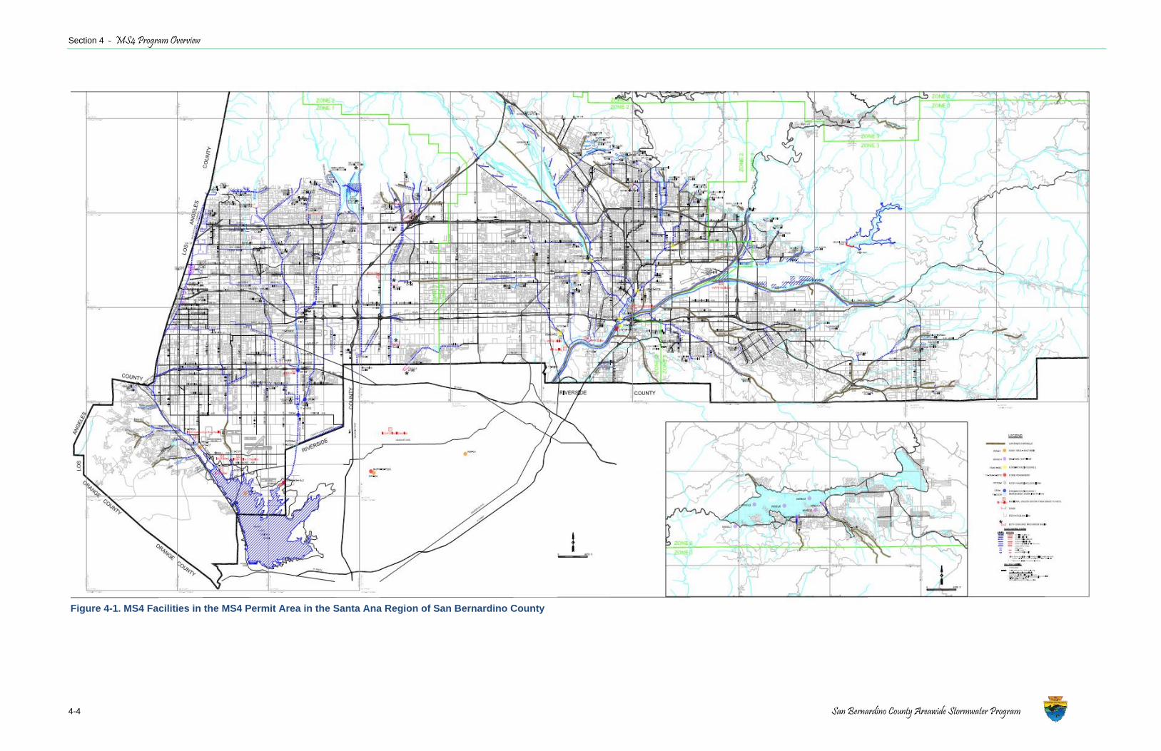
Section 4 - MS4 Program Overview
4-4 San Bernardino County Areawide Stormwater Program
Figure 4-1. MS4 Facilities in the MS4 Permit Area in the Santa Ana Region of San Bernardino County
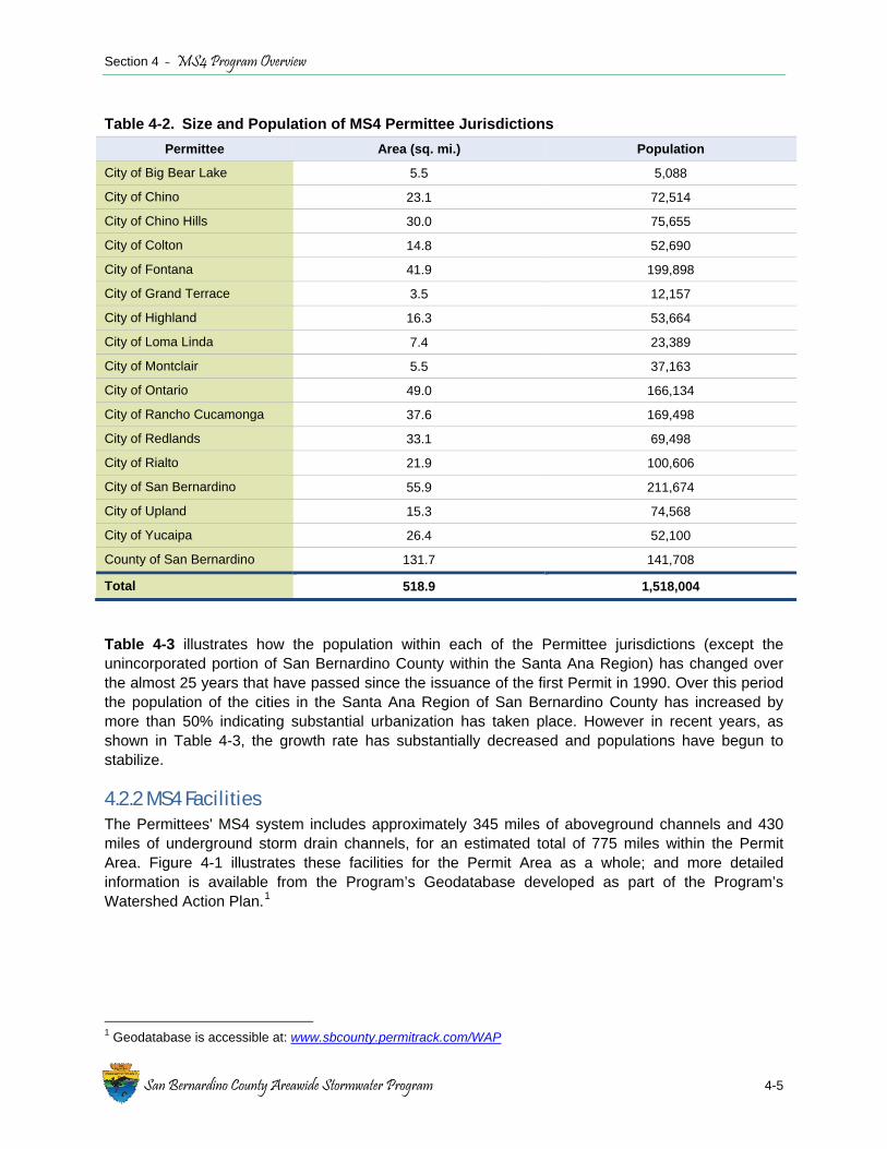
Section 4 - MS4 Program Overview
San Bernardino County Areawide Stormwater Program 4-5
Table 4-3 illustrates how the population within each of the Permittee jurisdictions (except the unincorporated portion of San Bernardino County within the Santa Ana Region) has changed over the almost 25 years that have passed since the issuance of the first Permit in 1990. Over this period the population of the cities in the Santa Ana Region of San Bernardino County has increased by more than 50% indicating substantial urbanization has taken place. However in recent years, as shown in Table 4-3, the growth rate has substantially decreased and populations have begun to stabilize.
4.2.2 MS4 Facilities The Permittees' MS4 system includes approximately 345 miles of aboveground channels and 430 miles of underground storm drain channels, for an estimated total of 775 miles within the Permit Area. Figure 4-1 illustrates these facilities for the Permit Area as a whole; and more detailed information is available from the Program’s Geodatabase developed as part of the Program’s Watershed Action Plan.1
1 Geodatabase is accessible at: www.sbcounty.permitrack.com/WAP
Table 4-2. Size and Population of MS4 Permittee Jurisdictions Permittee Area (sq. mi.) Population
City of Big Bear Lake 5.5 5,088
City of Chino 23.1 72,514
City of Chino Hills 30.0 75,655
City of Colton 14.8 52,690
City of Fontana 41.9 199,898
City of Grand Terrace 3.5 12,157
City of Highland 16.3 53,664
City of Loma Linda 7.4 23,389
City of Montclair 5.5 37,163
City of Ontario 49.0 166,134
City of Rancho Cucamonga 37.6 169,498
City of Redlands 33.1 69,498
City of Rialto 21.9 100,606
City of San Bernardino 55.9 211,674
City of Upland 15.3 74,568
City of Yucaipa 26.4 52,100
County of San Bernardino 131.7 141,708
Total 518.9 1,518,004

Section 4 - MS4 Program Overview
4-6 San Bernardino County Areawide Stormwater Program
Table 4-3. Current MS4 Permittee Population Estimate Compared to Population Estimated at Time of Each Permit Adoption (except unincorporated San Bernardino County in the Santa Ana Region)
Permittee Permit 1 1990
Permit 2 1996
Permit 3 2002
Permit 4 2010
Current Estimate
2013
City of Big Bear Lake 5,351 5,405 5,498 5,048 5,088
City of Chino 59,682 63,252 67,820 78,062 72,514
City of Chino Hills Not incorporated 53,063 70,488 74,738 75,655
City of Colton 40,273 44,440 49,327 52,066 52,690
City of Fontana 87,535 108,613 140,615 195,219 199,898
City of Grand Terrace 10,946 12,037 11,844 12,050 12,157
City of Highland 34,439 40,373 46,098 53,037 53,664
City of Loma Linda 18,470 19,327 20,345 23,218 23,389
City of Montclair 28,434 30,956 33,834 36,628 37,163
City of Ontario 133,179 145,459 161,051 164,015 166,134
City of Rancho Cucamonga 101,409 116,069 137,210 165,391 169,498
City of Redlands 60,395 62,904 65,678 68,752 69,498
City of Rialto 72,395 84,575 94,964 99,071 100,606
City of San Bernardino 164,676 180,428 192,045 209,656 211,674
City of Upland 63,374 65,566 70,357 73,732 74,568
City of Yucaipa 32,819 38,049 43,078 51,321 52,100
Total 913,377 1,070,516 1,210,252 1,362,004 1,376,296
4.3 MS4 Collaboration Through four Permit terms the San Bernardino County MS4 Program has been active in regional and state activities to develop effective approaches to manage stormwater in an urban environment. Staying active in this technical area ensures that the most up to date information on stormwater management techniques are readily available to the Permittees. Key areas where the Program is actively collaborating with other stakeholders include:
California Stormwater Quality Association The District is a Charter Member CASQA. CASQA assists California MS4 permittees with the implementation of effective stormwater management programs through collaboration and sharing of knowledge gained through more than 20 years of experience implementing programs to manage stormwater quality. Active participation in CASQA ensures that the many resources developed through CASQA (e.g., BMP Handbooks and construction BMP training) are available to the stormwater management staff in each Permittee’s jurisdiction. In addition, participation in CASQA allows the Permittees to participate in regular live webcasts conducted by CASQA.

Section 4 - MS4 Program Overview
San Bernardino County Areawide Stormwater Program 4-7
Santa Ana “One Water One Watershed” Initiative The District, on behalf of the Permittees, is an active participant in the SAWPA-led OWOW planning process which focuses on establishing regional solutions for water problems within the Santa Ana Region and is intended to develop linkages among all water interests. The OWOW objective to encourage multi-benefit resource projects, including capture and use of stormwater, is consistent with water management goals in the Permit area. Currently, James Ramos, County of San Bernardino, and Patrick Morris, City of San Bernardino, participate as members of the OWOW Steering Committee.
Southern California Stormwater Monitoring Coalition (SMC) SMC develops technical information collaboratively with a number of city, county and state agencies, including the Regional Board, through a cooperative agreement to provide a better understanding of stormwater mechanisms and impacts and develop tools to improve stormwater management. The District is a signatory to the SMC cooperative agreement and has worked collaboratively with them on projects such as the Regional Bioassessment Monitoring Program.
Regional Stormwater-related Management The Permittees continue to be actively involved in regional Task Forces, administered by SAWPA, and other activities to improve runoff quality and protect receiving waters:
♦ Stormwater Quality Standards Task Force – Comprised of stakeholders in the Santa Ana River Watershed, the District has been working collaboratively with the Regional Board and other regional stakeholders to develop the scientific and technical basis for modifications of existing bacteria quality objectives to protect recreational uses. The outcome was a Regional Board-approved amendment2 to the Santa Ana Region Water Quality Control Plan (Basin Plan) that created new bacterial indicator water quality objectives for the protection of REC-1 and REC-2 beneficial uses, established a high flow suspension of bacterial indicator objectives during wet weather events, and removed REC-1 as a beneficial use from Cucamonga Creek Reach 1 (from the base of the Cucamonga Canyon Dam to Hellman Avenue) These Basin Plan modifications have been approved by the State Water Resources Control Board3 and are currently under EPA Region 9 review. The outcome of the work of this Task Force will affect stormwater management decisions related to the protection of recreational uses.
♦ Middle Santa Ana River Bacteria TMDL Task Force – Comprised of stakeholders in the MSAR watershed, including several Permittees, this Task Force works collaboratively to implement a watershed-wide compliance monitoring program and bacteria source evaluation activities to support efforts to comply with MSAR Bacterial Indicator TMDL requirements.
♦ Big Bear Lake Nutrient TMDL – The District is working collaboratively with County of San Bernardino, City of Big Bear Lake, the ski resorts and BBMWD within the watershed to implement activities to support compliance with the TMDL. The District is also overseeing the watershed-wide monitoring program.
2 Regional Board Resolution R8-2012-0001 3 State Water Board Resolution 2014-0005, January 21, 2014
Section 4 - MS4 Program Overview
4-8 San Bernardino County Stormwater Program
4.4 MS4 Program Resources Table 4-4 summarizes the Permittee’s expenditures by fiscal year (FY) during the current Permit term. The District’s expenditures are shown separately from the other Permittees because these annual amounts include activities beyond implementation of the Program, such as facility modification, enhancement and/or new construction. It is also important to note that these projects are performed intermittently. Typically, the District will accumulate and “set aside” funds for specific projects over a multi-year period, and then expend the funds over the course of one or two years for construction activities (as can be seen in years 2012-13 and 2013-14). However, regardless of whether the District’s expenditures are included, it is clear that total program expenditures reflect the impact of ongoing negative economic conditions. This information is of considerable interest given the evaluation of program effectiveness, to be discussed in Section 5. Key facts to consider include the following:
♦ The overall San Bernardino County MS4 Program for the Santa Ana Region has had to implement Permit requirements, including TMDL compliance activities, during a period of significantly reduced fiscal resources.
♦ While it is expected that the fiscal resources available in upcoming years will at least remain static, i.e., not decline further (assuming economic conditions do not again worsen), the Program has had to become very efficient in program execution. However, this means that program efficiencies have already been achieved. The addition of new programs or requirements to significantly modify existing programs will not be accomplished with new monies. They will only be accomplished through the diversion of resources from existing programs and water quality management projects.

Section 4 - MS4 Program Overview
San Bernardino County Areawide Stormwater Program 4-9
Table 4-4. MS4 Permittee Program Expenditures by Fiscal Year
Permittee 2009-10 2010-11 2011-12 2012-13 2013-14
City of Big Bear Lake $1,308,200 $1,736,000 $1,606,000 $1,628,000 $1,626,000
City of Chino $711,275 $660,355 $718,921 $582,629 $702,676
City of Chino Hills $534,470 $426,500 $474,300 $402,430 $417,300
City of Colton $680,000 $680,000 $572,856 $572,856 $572,856
City of Fontana $1,479,266 $2,101,724 $1,895,337 $2,683,834 $2,593,152
City of Grand Terrace $161,905 $64,716 $83,668 $99,025 NR
City of Highland $491,678 $460,500 $473,320 $534,000 $549,500
City of Loma Linda $185,000 $188,000 $211,000 $219,000 $222,000
City of Montclair $653,928 $434,985 $453,659 $459,473 $419,212
City of Ontario $2,018,549 $2,142,684 $2,149,181 $2,359,343 $2,594,469
City of Rancho Cucamonga $1,345,931 $1,222,072 $1,233,835 $1,160,058 $1,290,428
City of Redlands $421,000 $417,700 $423,500 $431,400 $1,204,112
City of Rialto $551,810 $608,381 $456,496 $572,200 $330,668
City of San Bernardino $2,068,680 $1,964,058 $2,338,260 $2,193,416 $2,190,642
City of Upland $866,672 $292,204 $264,750 $341,970 $345,500
City of Yucaipa $259,000 $259,000 $259,000 $250,000 $238,000
County of San Bernardino 5,599,936 4,430,001 2,481,243 3,535,576 3,501,200
Total (without District) $13,737,364 $13,658,879 $13,614,083 $14,489,634 $15,296,515
San Bernardino County Flood Control District $26,056,178 $26,911,110 $25,904,104 $41,8174,74 $56,622,844
Total (with District) $39,793,542 $40,569,989 39,518,187 $56,307,108 $71,919,359

Section 4 - MS4 Program Overview
4-10 San Bernardino County Stormwater Program
This page intentionally left blank
San Bernardino County Areawide Stormwater Program
5-1
Section 5 MS4 Program Evaluation
This section provides an overall evaluation of the San Bernardino County MS4 Program in the Santa Ana Region under the current permit term. This evaluation is completed in three areas: (a) Program implementation highlights; (b) water quality characterization considering results from ongoing water quality monitoring programs; and (c) program effectiveness evaluation.
5.1 Program Implementation The 2010 Permit included a substantial number of permit deliverables that required a significant expenditure of program resources to complete. Table 5-1 summarizes the key permit deliverables and their status. A complete listing of permit deliverables may be found in Attachment 5, Section VII of the Permit.
Table 5-1. Key Permit Deliverables for 2010 Permit Term
Permit Deliverable Completion Status
Establish Local Implementation Plan (LIP) template for use by area-wide program and establishment of LIPs by each Permittee
All Permittees have established their LIPs
Develop CBRP for MSAR Bacterial Indicator TMDL Regional Board approved on February 10, 2012 (Resolution No. R8-2012-0015)
Implement Big Bear Lake TMDL requirements Completed annual monitoring and reporting requirements
Update MS4 Solutions Database to incorporate new modules and keep database current with Permit needs Continual
Develop Phase 1 and 2 elements of the WAP Regional Board approved Phase 1 on July 6, 2011; Phase 2 submitted to the Regional Board May 8, 2013
Revise WQMP to incorporate LID requirements for new development and significant redevelopment projects
Approved by the Regional Boardon June 21, 2013
Develop Transportation Project Guidance to incorporate low impact development practices into road projects
Approved by the Regional Boardon June 21, 2013
Revise the Integrated Watershed Monitoring Plan (IWMP) Approved by the Regional Board December 16, 2011
Establishment of Geodatabase to support implementation of the WAP
Geodatabase went live on September 19, 2013
Public Education and Outreach - Pet Waste Reduction Campaign Ongoing
Household Hazardous Waste and Cooking Oil Disposal education campaigns Completed
Section 5 - MS4 Program Evaluation
5-2 San Bernardino County Areawide Stormwater Program
The fourth term Permit fine-tuned a number of program areas, such as updates to the MSWMP and inspection programs; and laid the foundation for the next generation of stormwater management through incorporation of LID principles into urban development activities and adoption of the CBRP that targets Program activities towards fixing real water quality problems in the MSAR watershed. The following subsections highlight examples of key deliverables and the benefits they have provided to program implementation. The Program’s Annual Reports submitted during the course of the fourth permit term provide a complete record of program deliverables.
Implementation of Low Impact Development Principles Permit Outcome The current Permit required incorporation of LID principles into the management of stormwater from land development activities. Implementation of LID principles places increased reliance on natural processes and natural landscapes to manage urban runoff as close to its source as possible. An important benefit that can be derived from the application of LID principles to new development or significant redevelopment activities is the opportunity to use stormwater as a resource rather than a waste product. In particular, application of LID principles in the urban environment promotes numerous regional benefits including enhanced water quality and supply, stream and habitat protection, cleaner air, reduced urban temperature, increased energy efficiency, and improved community aesthetics and recreational opportunities.
LID principles have been integrated into the Program at multiple levels, including watershed level coordination occurring under the WAP (see below), and through their application to the planning and design of urban projects. In this regard, the Program revised its WQMP, which includes guidance for application of LID principles to transportation projects (Appendix A to Technical Guidance Document for Water Quality Management Plans).
Benefit to Program Implementation As the Program continues to shift towards on-site stormwater management, the application of LID principles to urban development will be an important element in mitigating water quality concerns, especially for compliance with the MSAR Bacterial Indicator TMDL. This new, but green-focused, approach to development will be critical to the design and implementation of projects that reduce pollutant loads and utilize stormwater as resource. An example of a recently completed LID-based project is provided in Section 5.4.7.
The regional water quality benefits of site specific LID development design will not be immediately recognized. These design criteria were developed and implemented in the land development downturn. While there are projects in process, the quantity of priority projects is significantly lower than in the past. This situation has allowed for the planning agencies to strategically prepare for future development projects.
MSAR Bacteria TMDL Implementation Permit Outcome A key outcome from the current Permit cycle has been the development of the CBRP by the Permittees subject to the MSAR Bacterial Indicator TMDL1. This TMDL Implementation Plan establishes a program of implementation for Permittees to meet the dry weather TMDL WLAs applicable to urban runoff in the MSAR watershed. The CBRP was formally adopted by the Regional
1 Resolution No. R8-2005-0001; August 26, 2005
Section 5 - MS4 Program Evaluation
San Bernardino County Areawide Stormwater Program 5-3
Board on February 10, 2012. The overall status of the implementation of this plan is described in Section 5.2.3; Permittee-specific implementation activities are provided in Section 5.4.
Benefit to Program Implementation CBRP adoption shifted Program resources from planning activities to active implementation of projects and activities dedicated to addressing a high priority water quality concern. These activities include monitoring and assessment programs to identify and manage controllable sources of bacteria in the MSAR watershed. Implementation priorities for the next permit cycle are described below in Section 2.1.
Watershed Action Plan Permit Outcome The 2010 Permit required development of a WAP over two phases that “integrates water quality, stream protection, stormwater management, water conservation and re-use, and flood protection, with land use planning and development processes.” The first phase was approved by the Regional Board on July 6, 2011. This phase included development of a geodatabase and Hydrologic Conditions of Concern mapping. The second phase effort focused on integrating the geodatabase into the implementation of the MSWMP, WQMP, and TMDL documents; and developing and implementing a Hydromodification Management Plan to identify and evaluate impacts to a selection of drainage facilities deemed most susceptible to degradation. The outcome of this phase is currently under Regional Board review.
Benefit to Program Implementation The key WAP product is the Geodatabase which became live and available for use in September 2013. The Geodatabase is the primary interactive reference tool for plan review with regards to water quality, and was designed in such a manner as to allow for continuous live Internet access to stormwater facility data, reports and studies, and data to support other regulatory processes such as WQMP development and approvals, CWA Section 401 Water Quality Standards Certifications, and LID BMP feasibility evaluations. Establishment of this database provides a single, centralized, and maintained location for agency planners and project proponents to develop information to support permit applications.
Local Implementation Plans Permit Outcome The Permit required the development of an LIP Template to support development of LIPs by each of the Permittees. The LIPs describe the specific tools, processes, procedures and resources used by the Permittees to implement the MSWMP. All Permittees have established their respective LIPs.
Benefit to Program Implementation The LIPs provide a roadmap for all Permittee staff to follow to improve urban runoff quality within their jurisdictions. Because the LIP relies on the use of foundational program documents, such as the MSWMP, any changes to these base documents is automatically applied across the Permit area. With the LIPs established for each jurisdiction, jurisdictional resources have been shifted to implementing stormwater management activities to address specific water quality concerns.
Inspections Permit Outcome The Permit required updates to a number of inspection-related programs. In particular, the Permit required Permittees to review and revise their Illicit Connection/Illegal Discharge (IC/ID) program as

Section 5 - MS4 Program Evaluation
5-4 San Bernardino County Stormwater Program
needed to include a pro-active Illicit Discharge Detection and Elimination (IDDE) program using IDDE - A Guidance Manual for Program Development and Technical Assessments (IDDE Manual)2 or any other equivalent program. While the IC/ID programs within Permittee jurisdictions continue to be implemented to identify and mitigate illicit discharges, the Permittees have been actively implementing targeted IDDE techniques as part of ongoing dry weather bacteria source evaluations in the MSAR watershed. These techniques were incorporated into the MSAR Watershed Monitoring Plan3.
Benefit to Program Implementation IC/ID inspections and application of IDDE procedures are a key element of the implementation of TMDLs, especially the MSAR Bacterial Indicator TMDL. These procedures are in active use and will continue to be, especially as Permittees continue to identify, investigate and mitigate controllable sources of bacteria. The City of Chino completed localized IC/ID investigations which previously have been presented to the Regional Board (see also Section 5.4.4).
MS4 Solutions Database Updates Permit Outcome The Permit required a number of updates to databases used to document Program outcomes, e.g., numbers of inspections, BMP data, etc. The MS4 Solutions Database was established prior to the beginning of the current permit term, but it has been updated as needed to fulfill the requirements of the 2010 Permit.
Benefit to Program Implementation The database provides a quick resource for Permittees to record information critical to document programmatic activities, including inspections, municipal activities, outreach and fiscal data. Regional Board staff also has limited access to the database which enhances communication between the Program and Regional Board staff.
Monitoring Programs Permit Outcome Monitoring activities related to Permit implementation occur under the Program’s IWMP. During the current permit term, the Program was required to develop an IWMP to guide local and regional monitoring in the area under permit jurisdiction. The Program submitted its IWMP to the Regional Board in January 2011; the Regional Board subsequently approved the plan on December 16, 2011. The IWMP incorporates all MS4 monitoring activities required by the Permit, including an overall monitoring strategy, core monitoring requirements, IC/ID strategy, and regional monitoring requirements. TMDL monitoring requirements are incorporated by reference.
Benefit to Program Implementation The establishment of the IWMP and associated TMDL Monitoring Programs provides the monitoring and assessment tools needed to guide implementation activities – especially for the TMDL monitoring programs which are used to evaluate the effectiveness of TMDL implementation activities to mitigate pollutants. With the IWMP and TMDL Monitoring Programs established, the Program has the tools it needs to continue to evaluate program effectiveness at improving runoff quality and protecting receiving water quality.
2 Center for Watershed Protection and Dr. Robert Pitt, University of Alabama, 2005 3 http://www.sawpa.org/wp-content/uploads/2013/01/MSAR-TMDL-MP-Tier-2-Addendum.pdf

Section 5 - MS4 Program Evaluation
San Bernardino County Areawide Stormwater Program 5-5
Public Education and Outreach (PEO) Permit Outcome The Program reduces the amount of pollutants in urban runoff – including pesticides, fertilizers, paint and pet waste – through the implementation of an active PEO program that encourages residents and businesses to adopt on-site pollution prevention practices. The program has three primary goals:
♦ Continue to increase awareness of stormwater pollution and its impact on our environment;
♦ Continue to educate residents and businesses on how to change their behavior to minimize stormwater pollution; and
♦ Maintain compliance with the Permit.
The overall program strategy focuses on directing San Bernardino County residents and businesses to available resources that when implemented have the highest potential to reduce pollutants in urban runoff. Implementation of this strategy in 2012-2013 included:
♦ Conduct Pollutant-Specific Residential Campaign - In 2012-2013 the program launched a residential campaign targeting dog owners and encouraging them to pick up after their dogs (see additional discussion below).
♦ Website and Social Media - The Program’s website provided residents and businesses news and information on the program’s efforts to reduce stormwater pollution and served as a platform for the residential campaign; in addition, its social media channel encouraged interaction with the Program and complemented offline outreach efforts.
Following are two key examples of PEO implementation and the benefits to the Program in the most recent reporting year (see Annual Reports for additional information):
♦ Pet Waste Reduction Campaign - Raising awareness regarding pet waste management is a key element in the implementation of the CBRP. To raise awareness of the stormwater pollution hazards associated with pet wastes and to give residents an incentive to pick up after their pets, the Program conducted a comprehensive outreach campaign that combined sweepstakes, a specific webpage, public relations, online advertising, and social media. The campaign focused on asking dog owners to carry a visible waste bag. The goal of the campaign was to establish carrying a bag as a social norm and demonstrate a 5% increase in incidences of dog owners picking up dog waste. The campaign employed three intervention tactics to change behavior: (a) Messaging to perform the target behavior (e.g., "no excuses!"); (b) Provision of free doggie waste bag canisters; and (c) asking dog owners to sign a pledge form to pick up after their dogs. Details regarding how each of these tactics were employed is provided in the 2012-2013 Annual Report.
♦ Household Hazardous Waste Collection - Each year the Program coordinates with the San Bernardino County Fire Department’s Household Hazardous Waste (HHW) Collection Program to develop informational material to reduce the potential for pollutants to runoff from residential properties. This program has resulted in the prevention of a tremendous volume of waste material being a source of pollutants in urban runoff. In the most recent reporting year, approximately 30,147 participants deposited waste materials at the HHW collection site. The result was the collection of over 2.1 million pounds of waste in just a single fiscal
Section 5 - MS4 Program Evaluation
5-6 San Bernardino County Stormwater Program
year (see long term trend in Figure 5-13). Generally, the volume of waste collected increased from 1996 to 2008-09. The reduction in collected waste since that time may reflect the economic downturn, resulting in less home construction projects and fewer new technology purchases. In addition, more companies are providing electronic recycling services in fulfillment of corporate “green” objectives. Regardless, the high volume of waste collected is providing substantial environmental benefits to the Permit Area.
5.2 Water Quality and Flow Characterization The Program conducts water quality monitoring to meet specific Permit requirements and implements specific water quality and water quantity studies to improve understanding of water quality and water management issues to guide and prioritize urban runoff management decisions. Activities include:
♦ MS4 Core Monitoring Program – The IWMP establishes the core monitoring program for the Permit. Emphasis is on wet weather event sampling.
♦ Dry Weather Flow Data – The Program is working with water agencies to document the amount of dry weather flow captured and recharged in the permit area. Increased recharge reduces the potential for pollutants in dry weather flow to impact downstream receiving waters.
♦ MSAR Bacteria TMDL Implementation – Monitoring required by the TMDL and specified in the CBRP involves a combination of watershed-wide compliance monitoring to assess receiving water quality and bacteria source evaluation studies in tributary subwatersheds to identify controllable sources of bacterial indicators.
♦ Big Bear Lake Nutrient TMDL Implementation – The Program is responsible for Watershed-wide monitoring in the watershed surrounding Big Bear Lake.
The following sections provide a brief characterization of water quality in the Permit area based on the findings from these monitoring program activities. References to more detailed analyses are provided where needed.
5.2.1 MS4 Stormwater Monitoring 2010 MS4 Permit Priorities Based on information developed by the Program as part of the development of the ROWD submitted in 2006 (MS4 application for the 2010 Permit), the Regional Board made, and included in the 2010 Permit4, the following key finding regarding water quality priorities:
“Based on the evaluation of monitoring data described above, the ROWD prioritized the pollutants of concern with regards to storm water management as follow: a. High Priority: Coliform bacteria b. Medium Priority: Zinc, copper, lead c. Low Priority: Nutrients, COD (chemical oxygen demand), TSS (total suspended solids).”
Current Water Quality Priorities Water quality data collected by the Program are routinely summarized and reported to the Regional Board in the program’s Annual Report. These data are incorporated by reference and not repeated
4 2010 MS4 Permit Section II.E, Finding 23
Section 5 - MS4 Program Evaluation
San Bernardino County Areawide Stormwater Program 5-7
here. Based on a data review and a comparison of the data results with appropriate water quality objectives, California Toxics Rule criteria, or EPA stormwater monitoring benchmarks5, the following findings have been make with regards to water quality priorities for the next permit term:
♦ High Priority: E. coli – This constituent continues to be a high priority for the permit area; it is actively being addressed in the MSAR watershed through the implementation of the CBRP (see Section 2.1.1). Additional waters are currently listed as impaired for pathogens (i.e., E. coli), but many of these waters are currently being further assessed by the Regional Board to determine if the impairment finding is accurate (see Table 5-3).
♦ Medium Priority – No constituents are considered a medium priority. The previous finding in 2006 was based on use of total recoverable metals data. The appropriate measure for evaluating metals compliance is the use of dissolved metals data. These data have been collected during the current permit term and show that no exceedances of acute dissolved metals criteria6.
♦ Low Priority: Nutrients, COD, TSS
- COD – This constituent occasionally exceeds the Basin Plan water quality objective (30 mg/L). The basis for the 30 mg/L COD water quality objective in the Basin Plan is unknown; however, it appears to have originally been intended to apply to wastewater discharges. While its relevance to wet weather discharge is unclear, it is notable that the EPA Stormwater Benchmark is 120 mg/L. Exceedances of this threshold occur with less frequency.
- TSS – Only occasional exceedances of the EPA stormwater monitoring benchmark (100 mg/L) occur.
- Total Inorganic Nitrogen – Only occasional exceedances of the Basin Plan water quality objective of 10 mg/L have been observed.
- Phosphorus – Except for a waterbody-specific numeric water quality objective for Big Bear Lake, no numeric objectives have been established for waterbodies in the Santa Ana Region of San Bernardino County. In addition there are no applicable federal criteria. There are EPA stormwater benchmarks established; a conservative value is 2 mg/L. This value was only exceeded once in the County over the past two years.
5.2.2 Santa Ana Region Dry Weather Flow Capture and Recharge The San Bernardino County portion of the Santa Ana River watershed is very unique. Not only is it almost completely on an alluvial fan (high percolation), but the Santa Ana River is primarily at the south end of the jurisdiction. Both of these geographical and geological features allows for the watershed to be highly managed for stormwater capture and reuse. Through implementation of the duties of other regulatory entities and compliance with other legal requirements, a significant number of basins that capture and recharge urban runoff, stormwater, recycled water and imported water have been constructed in the Permit Area. For almost 20 years, the District has been working with both Inland Empire Utilities Agency (IEUA) and San Bernardino Valley Municipal Water District collaborating on regional water recharge. As an adjudicated watershed, management decisions must 5 EPA’s Proposed 2013 Multi-Sector General Permit 6 For wet weather samples, only the acute metals criteria are relevant given the exposure assumptions associated with stormwater runoff events.
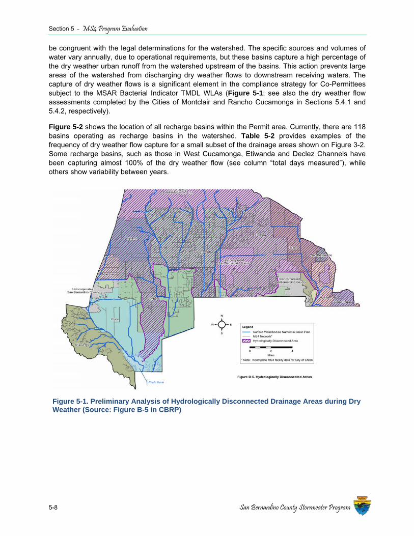
Section 5 - MS4 Program Evaluation
5-8 San Bernardino County Stormwater Program
be congruent with the legal determinations for the watershed. The specific sources and volumes of water vary annually, due to operational requirements, but these basins capture a high percentage of the dry weather urban runoff from the watershed upstream of the basins. This action prevents large areas of the watershed from discharging dry weather flows to downstream receiving waters. The capture of dry weather flows is a significant element in the compliance strategy for Co-Permittees subject to the MSAR Bacterial Indicator TMDL WLAs (Figure 5-1; see also the dry weather flow assessments completed by the Cities of Montclair and Rancho Cucamonga in Sections 5.4.1 and 5.4.2, respectively).
Figure 5-2 shows the location of all recharge basins within the Permit area. Currently, there are 118 basins operating as recharge basins in the watershed. Table 5-2 provides examples of the frequency of dry weather flow capture for a small subset of the drainage areas shown on Figure 3-2. Some recharge basins, such as those in West Cucamonga, Etiwanda and Declez Channels have been capturing almost 100% of the dry weather flow (see column “total days measured”), while others show variability between years.
Figure 5-1. Preliminary Analysis of Hydrologically Disconnected Drainage Areas during Dry Weather (Source: Figure B-5 in CBRP)
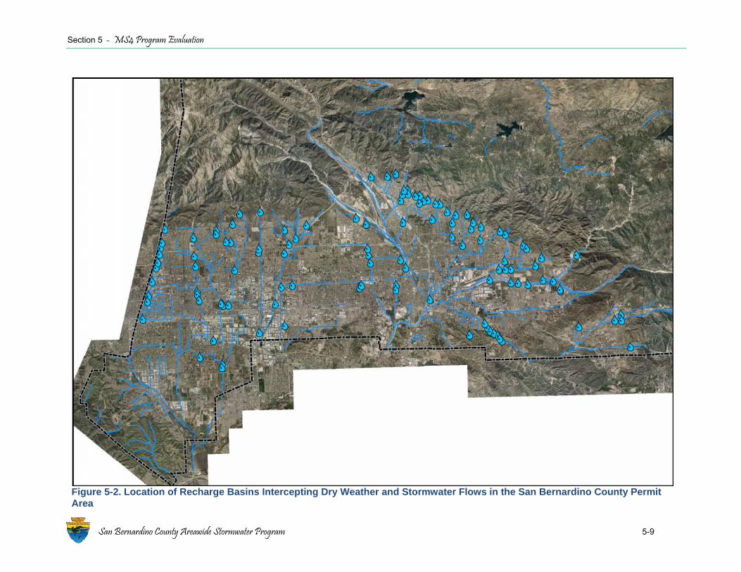
Section 5 - MS4 Program Evaluation
San Bernardino County Areawide Stormwater Program 5-9
Figure 5-2. Location of Recharge Basins Intercepting Dry Weather and Stormwater Flows in the San Bernardino County Permit Area
Section 5 - MS4 Program Evaluation
Table 5-2. Statistical Summary of Dry Weather Runoff Captured and Recharged in Selected Basins in the San Bernardino County Permit Area
Drainage Areas Waterbodies Location Description Period of Record
Total Recharge (ac-ft)1
DWF as % of Total
Recharge2
Total Days Runoff
Measured3
San Antonio Channel OC-59, CHE, CHW, Upland, Montclair, Brooks, OCWD
West End of County; Chino, Chino Hill, to Prado
Recharge is focused north of the 60 freeway (fwy); above the Salt Management Barrier; no recharge south of the 60 fwy
2006 – ‘07 45,824 1.9% 267
2007 – ‘08 2,928 100% 185
2008 – ‘09 4,750 32% 187
2009 – ‘10 16,227 18% 213
2010 – ‘11 18,072 27% 365
2011 – ‘12 64,619 18% 365
2012 – ‘13 4,128 18% 135
West Cucamonga Creek Ely, West Cucamonga, SNA gauge, 8th St., 7th St.
West/Central County; Rancho Cucamonga, Upland, Ontario
Recharge is focused just north of the 60 fwy; above the Salt Management Barrier
2006 – ‘07 3,720 88% 363
2007 – ‘08 6,021 56% 343
2008 – ‘09 1,955 96% 365
2009 – ‘10 11,122 78% 365
2010 – ‘11 10,017 31% 365
2011 – ‘12 7,952 40% 365
2012 – ‘13 7,979 17% 365
Cucamonga/Deer Creeks
Cucamonga Channel, Deer Creek, Turner Basins
West/Central County; Rancho Cucamonga and Ontario
Recharge is focused north of the 10 fwy; the airport and RP-1 is downstream of this point; also lower Cucamonga spreading grounds
2006 – ‘07 2,846 15% 251
2007 – ‘08 1,663 100% 285
2008 – ‘09 1,892 82% 275
2009 – ‘10 3,017 74% 322
2010 – ‘11 2,633 96% 332
2011 – ‘12 4,565 24% 365
2012 – ‘13 1,424 79% 255
5-10 San Bernardino County Areawide Stormwater Program
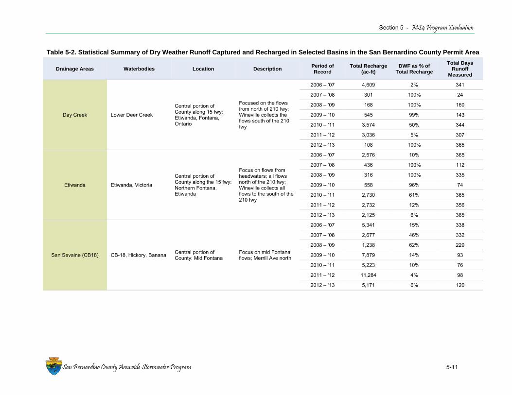
Section 5 - MS4 Program Evaluation
Table 5-2. Statistical Summary of Dry Weather Runoff Captured and Recharged in Selected Basins in the San Bernardino County Permit Area
Drainage Areas Waterbodies Location Description Period of Record
Total Recharge (ac-ft)
DWF as % of Total Recharge
Total Days Runoff
Measured
Day Creek Lower Deer Creek
Central portion of County along 15 fwy: Etiwanda, Fontana, Ontario
Focused on the flows from north of 210 fwy; Wineville collects the flows south of the 210 fwy
2006 – ‘07 4,609 2% 341
2007 – ‘08 301 100% 24
2008 – ‘09 168 100% 160
2009 – ‘10 545 99% 143
2010 – ‘11 3,574 50% 344
2011 – ‘12 3,036 5% 307
2012 – ‘13 108 100% 365
Etiwanda Etiwanda, Victoria
Central portion of County along the 15 fwy: Northern Fontana, Etiwanda
Focus on flows from headwaters; all flows north of the 210 fwy; Wineville collects all flows to the south of the 210 fwy
2006 – ‘07 2,576 10% 365
2007 – ‘08 436 100% 112
2008 – ‘09 316 100% 335
2009 – ‘10 558 96% 74
2010 – ‘11 2,730 61% 365
2011 – ‘12 2,732 12% 356
2012 – ‘13 2,125 6% 365
San Sevaine (CB18) CB-18, Hickory, Banana Central portion of County: Mid Fontana
Focus on mid Fontana flows; Merrill Ave north
2006 – ‘07 5,341 15% 338
2007 – ‘08 2,677 46% 332
2008 – ‘09 1,238 62% 229
2009 – ‘10 7,879 14% 93
2010 – ‘11 5,223 10% 76
2011 – ‘12 11,284 4% 98
2012 – ‘13 5,171 6% 120
San Bernardino County Areawide Stormwater Program 5-11
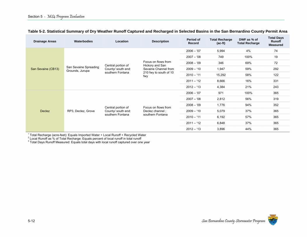
Section 5 - MS4 Program Evaluation
5-12 San Bernardino County Stormwater Program
Table 5-2. Statistical Summary of Dry Weather Runoff Captured and Recharged in Selected Basins in the San Bernardino County Permit Area
Drainage Areas Waterbodies Location Description Period of Record
Total Recharge (ac-ft)
DWF as % of Total Recharge
Total Days Runoff
Measured
San Sevaine (CB13) San Sevaine Spreading Grounds, Jurupa
Central portion of County/ south end: southern Fontana
Focus on flows from Hickory and San Sevaine Channel from 210 fwy to south of 10 fwy
2006 – ‘07 5,994 4% 74
2007 – ‘08 749 100% 19
2008 – ‘09 346 69% 72
2009 – ‘10 1,947 59% 292
2010 – ‘11 15,292 58% 122
2011 – ‘12 8,666 16% 331
2012 – ‘13 4,384 21% 243
Declez RP3, Declez, Grove Central portion of County/ south end: southern Fontana
Focus on flows from Declez channel ; southern Fontana
2006 – ‘07 971 100% 365
2007 – ‘08 2,812 56% 319
2008 – ‘09 1,776 94% 352
2009 – ‘10 5,079 37% 365
2010 – ‘11 6,192 57% 365
2011 – ‘12 6,848 37% 365
2012 – ‘13 3,896 44% 365 1 Total Recharge (acre-feet): Equals Imported Water + Local Runoff + Recycled Water 2 Local Runoff as % of Total Recharge: Equals percent of local runoff in total runoff 3 Total Days Runoff Measured: Equals total days with local runoff captured over one year

Section 5 - MS4 Program Evaluation
San Bernardino County Areawide Stormwater Program 5-13
5.2.3 MSAR Bacterial Indicator TMDL Monitoring Program The MSAR Bacteria TMDL requires monitoring of receiving waters to assess compliance with water quality objectives in impaired waterbodies (Watershed-wide Compliance Monitoring), and implementation of upstream bacteria source evaluations within the subwatersheds tributary to the impaired waters (originally characterized as the “Urban Source Evaluation Plan” in the TMDL, but replaced by “source evaluation monitoring activities”, as described in the CBRP).
Watershed-wide Compliance Monitoring The MSAR Bacterial Indicator TMDL requires implementation of a watershed-wide compliance monitoring program for bacterial indicators. Initiated in 2007, this program collects bacterial indicator data from five sites in the MSAR watershed. Dry weather samples are collected weekly over 20 consecutive weeks generally from May to September and over 11 consecutive weeks generally from late December through early March. In addition, one wet weather event is sampled each year, typically during late fall or early winter. The MSAR Bacteria TMDL Task Force, which oversees the monitoring effort, submits biannual seasonal data reports to the Regional Board to comply with CBRP reporting requirements.7 The TMDL (and CBRP) require development of Triennial Reports that summarize data collected for the preceding three year period and evaluate progress towards achieving the WLAs and load allocations (LAs). To date, two Triennial Reports have been submitted to the Regional Board (2010 and 2013)8. The next Triennial Report will be submitted in 2016.
Figure 5-3 summarizes bacterial indicator concentrations at watershed-wide compliance sites for dry weather conditions in the dry and wet seasons. Comparative wet weather data results are shown as sample points. Data collected to date show that there are significant differences in bacterial indicator concentrations among sites, three of which have at least some upstream drainage area within the Permit Area (Santa Ana River at MWD Crossing, Santa Ana River at Pedley, and Mill-Cucamonga Creek). Results consistently show clear differences in bacterial indicator concentration based on flow condition and season. Specifically, bacterial indicator concentrations are greatest during wet weather. For dry weather, lower bacterial indicator concentrations occur in the wet season than in the dry season. Several sites show a consistent pattern of increasing bacterial indicator concentration over the course of the summer dry season (e.g., see time series figures in the MSAR Bacterial Indicator TMDL 2013 Dry Season Report previously submitted to the Regional Board). The reason for this increase has not been determined.
Urban Source Evaluation – Tier 1 The CBRP includes source evaluation activities designed to identify controllable MS4 dry weather flow sources and their contributions to elevated bacterial indicator concentrations at downstream watershed-wide compliance sites. Source evaluation studies were conducted at Tier 1 locations in 2012 (all major MS4 drainage areas draining to a downstream watershed-wide compliance). Some of the Tier 1 monitoring sites were also sampled in 2007-2008 as part of early TMDL implementation activities. Tier 1 samples were analyzed for Total Suspended Solids (TSS) and E. coli concentrations, presence or absence of the human Bacteroides marker, and field measured parameters.
7 Reports are available from http://www.sawpa.org/collaboration/projects/tmdl-taskforce/ under the Monitoring webpage. 8 Reports are available from http://www.sawpa.org/collaboration/projects/tmdl-taskforce/ under the Resources webpage.

Section 5 - MS4 Program Evaluation
5-14 San Bernardino County Stormwater Program
Figure 5-3. Box-Whisker Plots of Bacterial Indicator Concentrations from 2009-2012 during Dry Weather in the Dry Season (red) and Wet Season (blue), and during Wet Weather Events (yellow points)
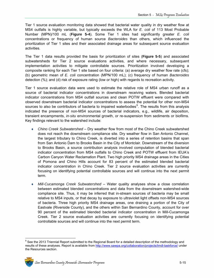
Section 5 - MS4 Program Evaluation
San Bernardino County Areawide Stormwater Program 5-15
Tier 1 source evaluation monitoring data showed that bacterial water quality in dry weather flow at MS4 outfalls is highly variable, but typically exceeds the WLA for E. coli of 113 Most Probable Number (MPN)/100 mL (Figure 5-4). Some Tier 1 sites had significantly greater E. coli concentrations or frequency of human source Bacteroides than others, which influenced the prioritization of Tier 1 sites and their associated drainage areas for subsequent source evaluation activities.
The Tier 1 data results provided the basis for prioritization of sites (Figure 5-5) and associated subwatersheds for Tier 2 source evaluations activities, and where necessary, subsequent implementation activities to mitigate controllable sources. Prioritization involved developing a composite ranking for each Tier 1 site based on four criteria: (a) average dry weather flow rate (cfs); (b) geometric mean of E. coli concentration (MPN/100 mL); (c) frequency of human Bacteroides detection (%); and (d) risk of exposure rating (low or high) with regards to recreation activity.
Tier 1 source evaluation data were used to estimate the relative role of MS4 urban runoff as a source of bacterial indicator concentrations in downstream receiving waters. Blended bacterial indicator concentrations from MS4 outfall sources and clean POTW effluent were compared with observed downstream bacterial indicator concentrations to assess the potential for other non-MS4 sources to also be contributors of bacteria to impaired waterbodies9. The results from this analysis indicated the presence of non-MS4 sources of bacterial indicators, e.g., wildlife, air deposition, transient encampments, in-situ environmental growth, or re-suspension from sediments or biofilms. Key findings relevant to the watershed include:
♦ Chino Creek Subwatershed – Dry weather flow from most of the Chino Creek subwatershed does not reach the downstream compliance site. Dry weather flow in San Antonio Channel, the largest tributary to Chino Creek, is diverted into a series of retention basins that span from San Antonio Dam to Brooks Basin in the City of Montclair. Downstream of the diversion to Brooks Basin, a source contribution analysis involved computation of blended bacterial indicator concentration from MS4 outfalls to Chino Creek and POTW effluent from IEUA’s Carbon Canyon Water Reclamation Plant. Two high priority MS4 drainage areas in the Cities of Pomona and Chino Hills account for 83 percent of the estimated blended bacterial indicator concentration in Chino Creek. Tier 2 source evaluation activities are currently focusing on identifying potential controllable sources and will continue into the next permit term.
♦ Mill-Cucamonga Creek Subwatershed – Water quality analyses show a close correlation between estimated blended concentrations and data from the downstream watershed-wide compliance site. Thus, it may be inferred that in-stream sources of bacteria may be small relative to MS4 inputs, or that decay by exposure to ultraviolet light offsets non-MS4 sources of bacteria. Three high priority MS4 drainage areas, one draining a portion of the City of Eastvale (Riverside County), and the others within San Bernardino County, account for over 90 percent of the estimated blended bacterial indicator concentration in Mill-Cucamonga Creek. Tier 2 source evaluation activities are currently focusing on identifying potential controllable sources and will continue into the next permit term.
9 See the 2013 Triennial Report submitted to the Regional Board for a detailed description of the methodology and results of these analyses. Report is available from http://www.sawpa.org/collaboration/projects/tmdl-taskforce/ under the Resources section.
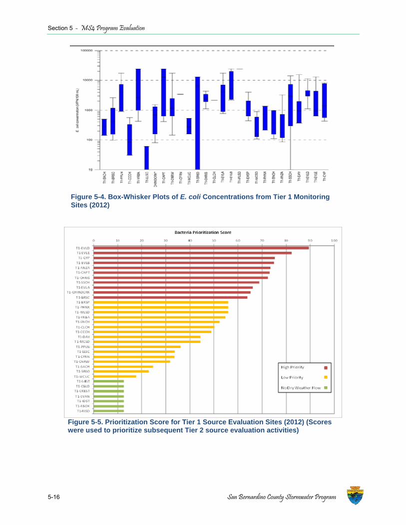
Section 5 - MS4 Program Evaluation
5-16 San Bernardino County Stormwater Program
Figure 5-4. Box-Whisker Plots of E. coli Concentrations from Tier 1 Monitoring Sites (2012)
Figure 5-5. Prioritization Score for Tier 1 Source Evaluation Sites (2012) (Scores were used to prioritize subsequent Tier 2 source evaluation activities)
Section 5 - MS4 Program Evaluation
San Bernardino County Areawide Stormwater Program 5-17
♦ Santa Ana River Subwatershed Within San Bernardino County - Most dry weather flow from MS4 drainage areas tributary to Santa Ana River Reach 3 is retained in recharge basins (including the Wineville, Riverside, Jurupa, and Declez Basins) which capture flow from Etiwanda Creek, Day Creek, San Sevaine Channel, and Declez Channel, respectively. The 2013 TMDL Implementation Report10 showed that the highest priority MS4 drainage areas to MSAR Reach 3 are Anza Drain in Riverside County and San Sevaine Channel (downstream of basins that capture dry weather flow in San Bernardino County). Upstream of Santa Ana River Reach 3, all dry weather flow in Reach 4 for of the Santa Ana River infiltrates into the river bed before La Cadena crossing, which is the upper boundary for Reach 3. Flow is re-established in Santa Ana River Reach 3 by the introduction of treated wastewater effluent from the RIX and the Rialto POTW facilities. Efforts to distinguish between controllable and uncontrollable sources will continue into the next permit term (see Section 2.1).
Urban Source Evaluation – Tier 2 The objective of Tier 2 source evaluations is to identify and mitigate or manage specific controllable urban sources most likely causing exceedances of bacterial indicator water quality objectives. During the 2013 dry season, Tier 2 source evaluations were conducted by Permittees within the jurisdictional area upstream of high priority Tier 1 sites. Specific actions included field reconnaissance, dry weather flow rate approximation, use of secondary screening tracers, and collection of samples for the bacterial indicator, E. coli, and human and non-human (ruminant, bovine, canine, avian, equine, etc.) specific Bacteroides analyses.
Part of the purpose of the Tier 2 assessment was to develop a better understanding of sources of dry weather flow within areas draining to MS4 outfalls. In particular, the assessment attempted to evaluate dry weather flow sources and patterns, as well as concentrations of E. coli within those flows. If elevated concentrations of indicator bacteria were found in a source of dry weather flow, specific Bacteroides analyses were performed to determine if the bacteria was from a human or animal source.
Results of the assessment determined that the rate of dry weather flow from a neighborhood scale drainage area is highly dynamic and a function of individual property owner irrigation schedules, which makes it impossible to conclude that any specific subarea persistently contributes dry weather flow or to quantify a daily volume of dry weather flow without continuous flow measurements. Therefore, quantitative water balances cannot be developed. Instead, dry weather flow rates were evaluated qualitatively to identify areas with elevated dry weather flow for further investigation.
Variability in bacterial indicator concentrations was substantial, with E. coli concentrations ranging from non-detect (< 9 MPN/100 mL) to greater than 10,000 MPN/100 mL. Spatial and temporal variability is very high with significant variability was observed both between sites and at the same site sampled over different weeks. In addition, numerous samples having elevated bacterial indicators were submitted for specific Bacteroides analyses (human and non-human).
During the 2013 summer dry season, only two detections of human-associated Bacteroides were recorded out of 23 samples tested. This relative percentage of detections is a little lower than previous years when samples were also analyzed for human Bacteroides (Figure 5-6). Based on the Program’s understanding of dry weather flow generation, this variability in E. coli concentration and the lack of a consistent presence of human-specific Bacteroides in these samples indicate that the
10 2013 TMDL Implementation Report; http://www.sawpa.org/wp-content/uploads/2013/01/CBRP-TMDL-Implementation_Final.pdf
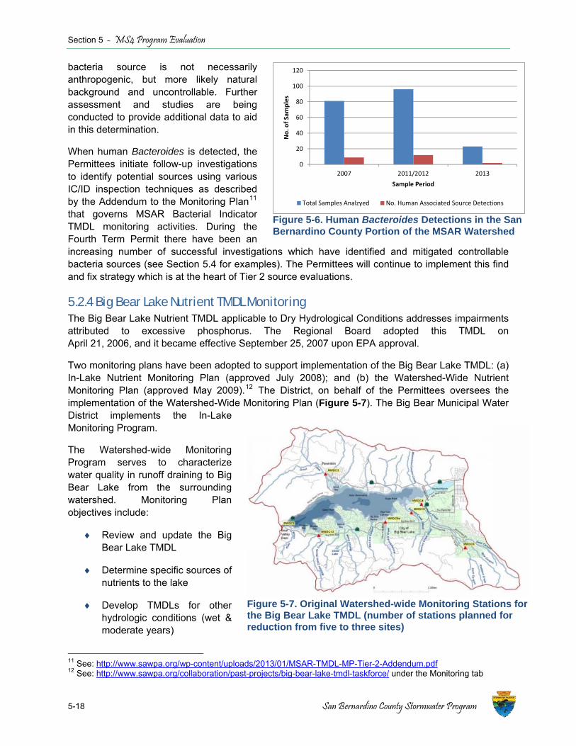
Section 5 - MS4 Program Evaluation
5-18 San Bernardino County Stormwater Program
bacteria source is not necessarily anthropogenic, but more likely natural background and uncontrollable. Further assessment and studies are being conducted to provide additional data to aid in this determination.
When human Bacteroides is detected, the Permittees initiate follow-up investigations to identify potential sources using various IC/ID inspection techniques as described by the Addendum to the Monitoring Plan11 that governs MSAR Bacterial Indicator TMDL monitoring activities. During the Fourth Term Permit there have been an increasing number of successful investigations which have identified and mitigated controllable bacteria sources (see Section 5.4 for examples). The Permittees will continue to implement this find and fix strategy which is at the heart of Tier 2 source evaluations.
5.2.4 Big Bear Lake Nutrient TMDL Monitoring The Big Bear Lake Nutrient TMDL applicable to Dry Hydrological Conditions addresses impairments attributed to excessive phosphorus. The Regional Board adopted this TMDL on April 21, 2006, and it became effective September 25, 2007 upon EPA approval.
Two monitoring plans have been adopted to support implementation of the Big Bear Lake TMDL: (a) In-Lake Nutrient Monitoring Plan (approved July 2008); and (b) the Watershed-Wide Nutrient Monitoring Plan (approved May 2009).12 The District, on behalf of the Permittees oversees the implementation of the Watershed-Wide Monitoring Plan (Figure 5-7). The Big Bear Municipal Water District implements the In-Lake Monitoring Program.
The Watershed-wide Monitoring Program serves to characterize water quality in runoff draining to Big Bear Lake from the surrounding watershed. Monitoring Plan objectives include:
♦ Review and update the Big Bear Lake TMDL
♦ Determine specific sources of nutrients to the lake
♦ Develop TMDLs for other hydrologic conditions (wet & moderate years)
11 See: http://www.sawpa.org/wp-content/uploads/2013/01/MSAR-TMDL-MP-Tier-2-Addendum.pdf 12 See: http://www.sawpa.org/collaboration/past-projects/big-bear-lake-tmdl-taskforce/ under the Monitoring tab
Figure 5-7. Original Watershed-wide Monitoring Stations for the Big Bear Lake TMDL (number of stations planned for reduction from five to three sites)
Figure 5-6. Human Bacteroides Detections in the San Bernardino County Portion of the MSAR Watershed
0
20
40
60
80
100
120
2007 2011/2012 2013
No. of Sam
ples
Sample Period
Total Samples Analzyed No. Human Associated Source Detections
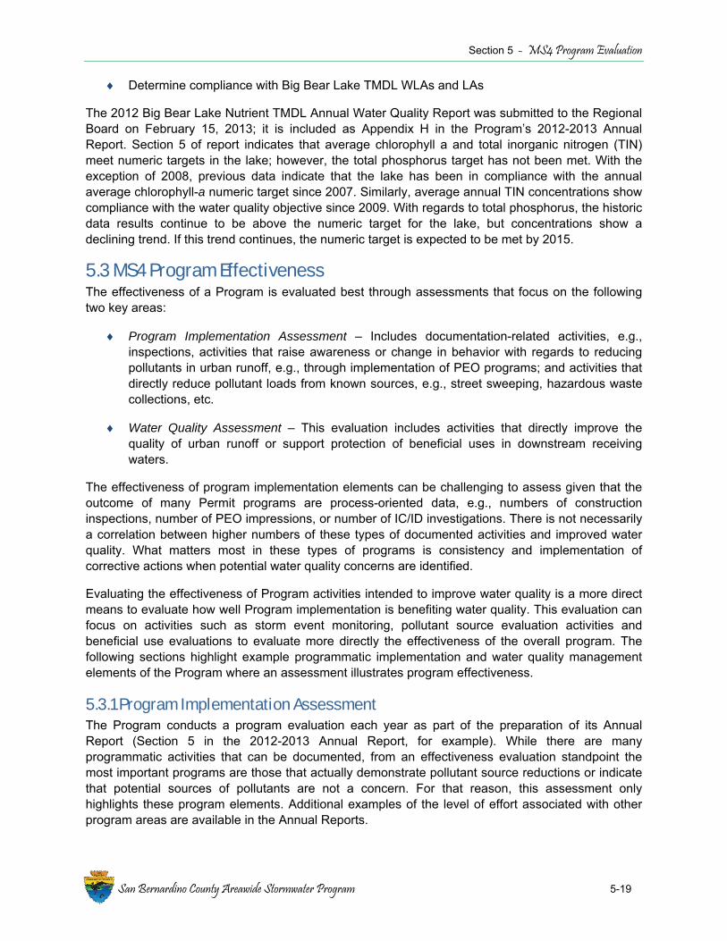
Section 5 - MS4 Program Evaluation
San Bernardino County Areawide Stormwater Program 5-19
♦ Determine compliance with Big Bear Lake TMDL WLAs and LAs
The 2012 Big Bear Lake Nutrient TMDL Annual Water Quality Report was submitted to the Regional Board on February 15, 2013; it is included as Appendix H in the Program’s 2012-2013 Annual Report. Section 5 of report indicates that average chlorophyll a and total inorganic nitrogen (TIN) meet numeric targets in the lake; however, the total phosphorus target has not been met. With the exception of 2008, previous data indicate that the lake has been in compliance with the annual average chlorophyll-a numeric target since 2007. Similarly, average annual TIN concentrations show compliance with the water quality objective since 2009. With regards to total phosphorus, the historic data results continue to be above the numeric target for the lake, but concentrations show a declining trend. If this trend continues, the numeric target is expected to be met by 2015.
5.3 MS4 Program Effectiveness The effectiveness of a Program is evaluated best through assessments that focus on the following two key areas:
♦ Program Implementation Assessment – Includes documentation-related activities, e.g., inspections, activities that raise awareness or change in behavior with regards to reducing pollutants in urban runoff, e.g., through implementation of PEO programs; and activities that directly reduce pollutant loads from known sources, e.g., street sweeping, hazardous waste collections, etc.
♦ Water Quality Assessment – This evaluation includes activities that directly improve the quality of urban runoff or support protection of beneficial uses in downstream receiving waters.
The effectiveness of program implementation elements can be challenging to assess given that the outcome of many Permit programs are process-oriented data, e.g., numbers of construction inspections, number of PEO impressions, or number of IC/ID investigations. There is not necessarily a correlation between higher numbers of these types of documented activities and improved water quality. What matters most in these types of programs is consistency and implementation of corrective actions when potential water quality concerns are identified.
Evaluating the effectiveness of Program activities intended to improve water quality is a more direct means to evaluate how well Program implementation is benefiting water quality. This evaluation can focus on activities such as storm event monitoring, pollutant source evaluation activities and beneficial use evaluations to evaluate more directly the effectiveness of the overall program. The following sections highlight example programmatic implementation and water quality management elements of the Program where an assessment illustrates program effectiveness.
5.3.1 Program Implementation Assessment The Program conducts a program evaluation each year as part of the preparation of its Annual Report (Section 5 in the 2012-2013 Annual Report, for example). While there are many programmatic activities that can be documented, from an effectiveness evaluation standpoint the most important programs are those that actually demonstrate pollutant source reductions or indicate that potential sources of pollutants are not a concern. For that reason, this assessment only highlights these program elements. Additional examples of the level of effort associated with other program areas are available in the Annual Reports.

Section 5 - MS4 Program Evaluation
5-20 San Bernardino County Stormwater Program
♦ Illicit Discharge Program (2012-2013) – A critical program element that targets and mitigates sources of pollutants in the MS4 is the illicit discharge program that targets both illegal connections and illicit discharges. Figure 5-8 illustrates the number of illicit discharge related events (including dumping and spills) that have occurred since 1996. Figure 5-9 illustrates how the Program addressed the 2012-2013 reported events. Over there the many years of implementation the number of these events from year to year varies between 200 and 400 events. The lack of a trend upward event during a period of significant population growth (see Section 4.4) and urbanization (as evidenced by population growth and numbers of construction permits (see Figure 5-14) indicates that the Program is implementing this program element effectively.
♦ Program Inspections (2012-2013) – A significant amount of Permittee staff time is spent conducting inspections of construction, industrial and commercial properties to ensure compliance with urban runoff management requirements. This program is key to reducing sources of pollutants to MS4 facilities and downstream waters.
Figure 5-8. Number of Illicit Discharge/Dumping or Spill Events by Year (1996-2013)
Figure 5-9. Resolution of Illicit Discharge Events Reported in 2013

Section 5 - MS4 Program Evaluation
San Bernardino County Areawide Stormwater Program 5-21
Figures 5-10a, 5-10b and Figures 5-11a, 5-11b present the inspection data for construction sites and commercial sites since 2004, respectively. Even as the need for inspections has increased due to increased development activity, the number of deficiencies identified has remained steady or even declined slightly. Per the 2012-2013 Annual Report, 1,788 deficiencies were identified during the reporting year for the construction, commercial, and industrial programs combined. Those requiring notices of correction were the most common (79%). Less than one percent required a cleanup and only one deficiency rose to the level that was considered criminal. The fact that most identified deficiencies only require a notice of correction, which through follow-up inspections are shown to be implemented, demonstrates the effectiveness of this program. Accordingly, the potential for construction, industrial or commercial activities to result in a water quality concern in the MS4 is low.
♦ Source Reduction Activities (2012-2013) – A review of the various programs where the removal of waste is quantified (e.g., through street sweeping, waste removal from Permittee facilities, or residential programs) shows that as in other years the Permittees are actively reducing the potential for waste and pollutants to be discharged to receiving waters (e.g., see Figure 3.6.1 in the 2012-2013 Annual Report which shows the types of pollutant sources managed during the year). Figure 5-12 shows that the total volume of household waste has generally increased over the period of record 1996-2013, and that significant pollutant sources are being kept from impacting the MS4.
The above highlights represent only a snapshot of program activities that are effectively removing or reducing potential sources of pollutants in urban runoff. Information regarding other programs that document results from program implementation is routinely reported in the Annual Reports submitted to the Regional Board by November 15th of each year.
5.3.2 Water Quality Assessment The best means to demonstrate program effectiveness is to directly evaluate the quality of urban runoff and degree to which the program is implementing projects or program activities that are or will demonstrably protect beneficial uses of receiving waters. Each of these elements is discussed below with examples provided to demonstrate how the San Bernardino County MS4 Program has shifted its program emphasis towards activities that directly improve water quality.
Improving Runoff Quality While it can be reasonably assumed that the rate of population growth is an adequate surrogate for the rate of urbanization, evidence that this assumption is true also can be seen in the record of construction permits issued over the 20+ year period from 1992 to 2013 (Figure 5-13). The period of elevated permit issuance coincides with a period of relatively rapid population growth. This growth lasted until approximately 2008-2009 when the most recent economic downturn began. Even with this period of rapid urbanization, the number of observed exceedances of water quality objectives in wet weather runoff remains low. This is a significant outcome and strong evidence of the effectiveness of the San Bernardino County MS4 Program and efforts to manage water resources overall in the watershed (see Figure 5-2 and location of recharge basins throughout the watershed.

Section 5 - MS4 Program Evaluation
5-22 San Bernardino County Stormwater Program
Figure 5-10a. Numbers of Construction Sites, Inspections, and Deficiencies Since 2004
0
1000
2000
3000
4000
5000
6000
7000
2004 2005 2006 2007 2008 2009 2010 2011 2012 2013
Total N
umbe
r of Events
# of Construction Sites # of Construction Inspections # of Inspections with Deficiencies Figure 5-11a. Numbers of Commercial Sites, Inspections, and Deficiencies Document Since 2004
0
2000
4000
6000
8000
10000
12000
2004 2005 2006 2007 2008 2009 2010 2011 2012 2013
Total N
umbe
r of Events
# of Commercial Facilities # of Commercial Inspections # of Inspections with Deficiencies
Figure 5-10b. Areawide Trend in Construction Sites, Inspections, and Deficiencies Since 2004
0
1000
2000
3000
4000
5000
6000
7000
2004 2005 2006 2007 2008 2009 2010 2011 2012 2013
Total N
umbe
r of Events
# of Construction Sites # of Construction Inspections # of Inspections with Deficiencies Figure 5-11b. Areawide Trend in Commercial Sites, Inspections and Deficiencies Since 2004
0
2000
4000
6000
8000
10000
12000
2004 2005 2006 2007 2008 2009 2010 2011 2012 2013
Total N
umbe
r of Events
# of Commercial Facilities # of Commercial Inspections # of Inspections with Deficiencies

Section 5 - MS4 Program Evaluation
San Bernardino County Areawide Stormwater Program 5-23
Figure 5-12. Total Household Hazardous Waste Collected by Fiscal Year
Figure 5-13. Number of Construction Permits Issued (1992-2013) in San Bernardino County (Source: Regional Board)
0
50
100
150
200
250
300
350
400
450
500
1992 1993 1994 1995 1996 1997 1998 1999 2000 2001 2002 2003 2004 2005 2006 2007 2008 2009 2010 2011 2012 2013
Num
ber of Con
struction Perm
its
Year
MS4 Permit Area ‐ Number of Construction Permits
Section 5 - MS4 Program Evaluation
5-24 San Bernardino County Stormwater Program
Additional evidence that urban runoff management is being effectively managed in the County is data showing the significant capture of dry weather flows in recharge basins by water agencies. In some subwatersheds almost 100% off the dry weather flows are being captured (See Table 5-2). Regular capture of this water does not just benefit the region through augmentation of local groundwater. With the adoption of new LID-based requirements for new development and significant redevelopment projects, during the current permit term, reductions in pollutant loads during wet or dry weather will continue to grow over the long term.
Protecting Receiving Water Quality Overview The ultimate goal of the Permit is to ensure that MS4 discharges do not cause or contribute to impairment of downstream receiving waters. Given that the number of exceedances of water quality objectives is quite low (see Section 5.2.1), the potential for urban runoff in the San Bernardino County Permit Area to be a source of impairment in downstream waters is likely limited to only two key pollutant categories: bacterial indicators and nitrogen. Where these pollutants have been shown to be causing impairment, TMDLs have already been established to address the impairments through the Big Bear Lake Nutrient TMDL and the MSAR Bacterial Indicator TMDL. Given these findings, it critical that the Program continue to focus its efforts on TMDL implementation activities to protect receiving waters, including those activities described in the Regional Board-approved CBRP for the San Bernardino County within the MSAR watersheds. Following are examples of implementation activities that are effective at protecting receiving water quality in the permit area and planned for continued implementation during the next permit term.
MSAR Bacteria TMDL Since at least 2008 and continuing with the adoption of the CBRP in 2012, the Program has been conducting a series of source evaluation assessments using inspection techniques to identify controllable sources of bacteria. Where human-associated sources of bacteria have been observed, investigations have been conducted to find and mitigate bacteria sources. Sections 5.4.3 and 5.4.4 provide examples of source evaluation activities completed or are ongoing in the watershed to support CBRP implementation. These implementation activities, which include dry weather flow assessments, have been effective in improving protection of receiving waters or demonstrating that some areas are not contributing bacterial indicators to downstream waters during dry weather (see Section is 5.4.1 and 5.4.2). As was described in Section 2.1.1, the Program will continue to target program resources on correcting controllable bacteria sources during the next permit term.
Big Bear Lake Nutrient TMDL The District, on behalf of the Permittees, oversees the implementation of the Watershed-Wide Monitoring Plan, with the BBMWD conducting the in-lake monitoring. Through these efforts it has been demonstrated that average chlorophyll-a and TIN meet numeric targets in the lake; however the total phosphorus target has not been met. As was described in Section 2.1.2 the Permittees are working with BBMWD on the implementation of an alum project for spring/summer 2015 that is expected to sequester approximately 20,000 pounds of phosphorus and will be more than enough to neutralize all of the urban phosphorous load that occurred in the 8 years TMDL approval. Moreover, the project is designed to ensure that urban sources are no longer causing or contributing to any future nutrient impairment in Big Bear Lake by neutralizing phosphorous loads in all but the wettest hydrological conditions. Through these efforts the Program will more than meet its minimum responsibilities under the TMDL.
Section 5 - MS4 Program Evaluation
San Bernardino County Areawide Stormwater Program 5-25
Other Potential Pollutants of Concern Other potential pollutants of concern in the Permit Area can be identified either through the findings of the Program water quality monitoring program (e.g., as summarized through Section 5.2.1) or through review of the 303(d) list applicable to the San Bernardino County MS4 Permit Area. Table 5-3 lists the waters identified as impaired on the state’s 303(d) list13. Some of these impairments are expected to be delisted during the next permit term based on updated bacterial indicator data being collected by the Regional Board. Others may be resolved simply through continued implementation of source reduction programs. For example, for copper and lead, vehicular traffic is the primary source of these metals in the urban environment: copper, present in vehicular brake pads, and lead, used in vehicle wheel weights. The State of California has adopted laws and regulations to reduce these metal sources. In 2010, the state adopted a new law that once fully implemented by the California Department of Toxic Substances Control will nearly eliminate copper use in brake pads (Senate Bill 346), which will greatly reduce this urban source of copper in wet weather runoff. Similarly, the State of California adopted a new law that prohibits the manufacture, sale, or installation in California of a wheel weight that contains more than 0.1% lead. Over time, the amount of lead attributable to this source during wet weather is expected to decline.
Recreational Use Basin Planning Activities Since 2003 the Program has invested substantial program resources working collaboratively with the Regional Board, non-governmental organizations (NGOs) and sister stormwater agencies on Basin Planning activities. This investment has directly supported the Regional Board’s efforts to implement effective water quality programs and will have a direct impact on the overall effectiveness of the Program for protecting receiving water quality well into the future.
On June 15, 2012, the Regional Board adopted a BPA (Resolution R8-2012-0001) that establishes revised requirements for the protection of recreational uses in the Permit Area and replaces the REC-1 bacteria water quality objectives with E. coli objectives. Regional Board staff developed this BPA in collaboration with the SWQSTF. The BPA was approved by the State Water Board on January 21, 2014. The BPA was approved by the OAL on July 2, 2014); it is currently under EPA review. The EPA is expected to act on the adopted BPA by the end of 2014. The outcome will be a revised approach for ensuring protection of recreational uses in the Permit area that supports the CBRP and affects how compliance with wet weather TMDL WLAs will be evaluated (e.g., taking into account application of a high flow suspension).
In anticipation of full implementation of the BPA following EPA action, the SWQSTF has begun work on a Regional Monitoring Plan that may influence bacteria-related monitoring activities within the area covered by the Permit, including those conducted under the CBRP. The Program will continue to invest resource in SWQSTF activities given the direct application to Permit implementation and future evaluations regarding the effectiveness of the Program.
13 The mostly recent state and EPA-approved 303(d) list for California is based on the State Water Board’s 2010 Integrated Report.
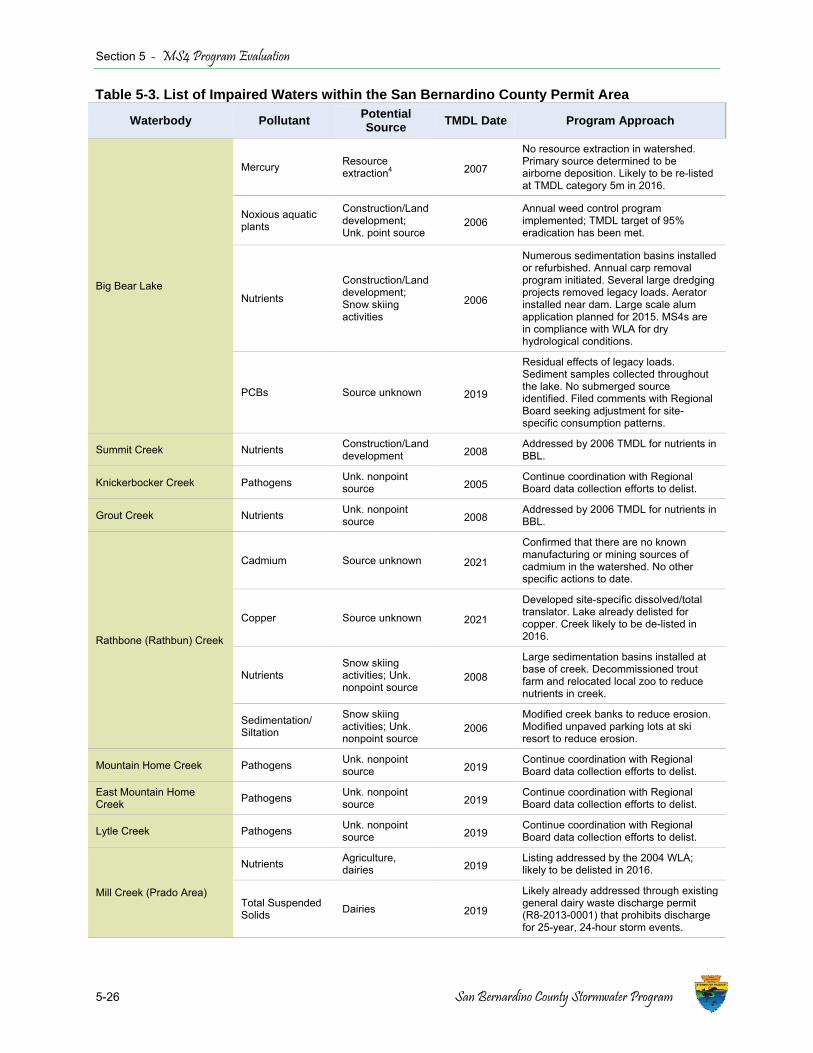
Section 5 - MS4 Program Evaluation
5-26 San Bernardino County Stormwater Program
Table 5-3. List of Impaired Waters within the San Bernardino County Permit Area
Waterbody Pollutant Potential Source TMDL Date Program Approach
Big Bear Lake
Mercury Resource extraction4 2007
No resource extraction in watershed. Primary source determined to be airborne deposition. Likely to be re-listed at TMDL category 5m in 2016.
Noxious aquatic plants
Construction/Land development; Unk. point source
2006 Annual weed control program implemented; TMDL target of 95% eradication has been met.
Nutrients
Construction/Land development; Snow skiing activities
2006
Numerous sedimentation basins installed or refurbished. Annual carp removal program initiated. Several large dredging projects removed legacy loads. Aerator installed near dam. Large scale alum application planned for 2015. MS4s are in compliance with WLA for dry hydrological conditions.
PCBs Source unknown 2019
Residual effects of legacy loads. Sediment samples collected throughout the lake. No submerged source identified. Filed comments with Regional Board seeking adjustment for site-specific consumption patterns.
Summit Creek Nutrients Construction/Land development 2008 Addressed by 2006 TMDL for nutrients in
BBL.
Knickerbocker Creek Pathogens Unk. nonpoint source 2005
Continue coordination with Regional Board data collection efforts to delist.
Grout Creek Nutrients Unk. nonpoint source 2008 Addressed by 2006 TMDL for nutrients in
BBL.
Rathbone (Rathbun) Creek
Cadmium Source unknown 2021
Confirmed that there are no known manufacturing or mining sources of cadmium in the watershed. No other specific actions to date.
Copper Source unknown 2021
Developed site-specific dissolved/total translator. Lake already delisted for copper. Creek likely to be de-listed in 2016.
Nutrients Snow skiing activities; Unk. nonpoint source
2008
Large sedimentation basins installed at base of creek. Decommissioned trout farm and relocated local zoo to reduce nutrients in creek.
Sedimentation/ Siltation
Snow skiing activities; Unk. nonpoint source
2006 Modified creek banks to reduce erosion. Modified unpaved parking lots at ski resort to reduce erosion.
Mountain Home Creek Pathogens Unk. nonpoint source 2019
Continue coordination with Regional Board data collection efforts to delist.
East Mountain Home Creek Pathogens Unk. nonpoint
source 2019 Continue coordination with Regional Board data collection efforts to delist.
Lytle Creek Pathogens Unk. nonpoint source 2019
Continue coordination with Regional Board data collection efforts to delist.
Mill Creek (Prado Area)
Nutrients Agriculture, dairies 2019
Listing addressed by the 2004 WLA; likely to be delisted in 2016.
Total Suspended Solids Dairies 2019
Likely already addressed through existing general dairy waste discharge permit (R8-2013-0001) that prohibits discharge for 25-year, 24-hour storm events.
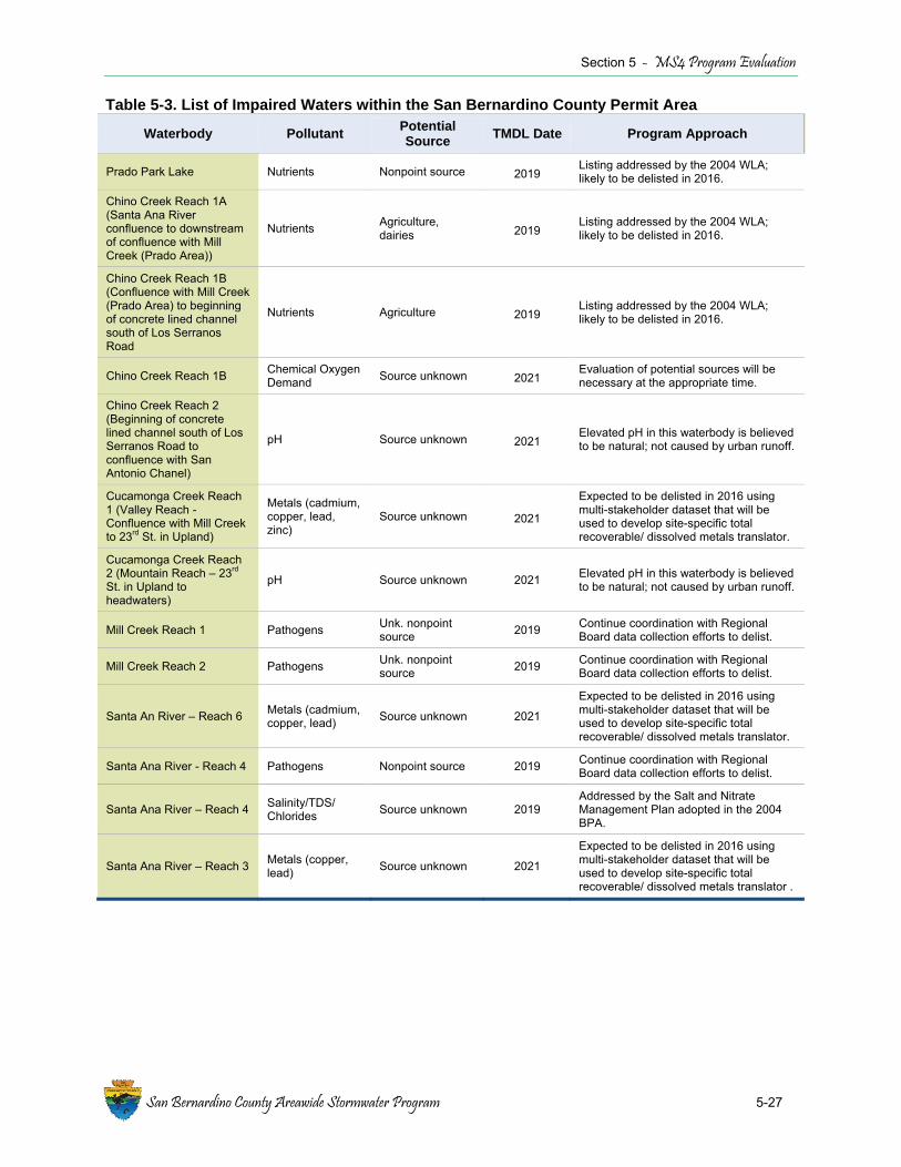
Section 5 - MS4 Program Evaluation
San Bernardino County Areawide Stormwater Program 5-27
Table 5-3. List of Impaired Waters within the San Bernardino County Permit Area
Waterbody Pollutant Potential Source TMDL Date Program Approach
Prado Park Lake Nutrients Nonpoint source 2019 Listing addressed by the 2004 WLA; likely to be delisted in 2016.
Chino Creek Reach 1A (Santa Ana River confluence to downstream of confluence with Mill Creek (Prado Area))
Nutrients Agriculture, dairies 2019
Listing addressed by the 2004 WLA; likely to be delisted in 2016.
Chino Creek Reach 1B (Confluence with Mill Creek (Prado Area) to beginning of concrete lined channel south of Los Serranos Road
Nutrients Agriculture 2019 Listing addressed by the 2004 WLA; likely to be delisted in 2016.
Chino Creek Reach 1B Chemical Oxygen Demand Source unknown 2021
Evaluation of potential sources will be necessary at the appropriate time.
Chino Creek Reach 2 (Beginning of concrete lined channel south of Los Serranos Road to confluence with San Antonio Chanel)
pH Source unknown 2021 Elevated pH in this waterbody is believed to be natural; not caused by urban runoff.
Cucamonga Creek Reach 1 (Valley Reach - Confluence with Mill Creek to 23rd St. in Upland)
Metals (cadmium, copper, lead, zinc)
Source unknown 2021
Expected to be delisted in 2016 using multi-stakeholder dataset that will be used to develop site-specific total recoverable/ dissolved metals translator.
Cucamonga Creek Reach 2 (Mountain Reach – 23rd St. in Upland to headwaters)
pH Source unknown 2021 Elevated pH in this waterbody is believed to be natural; not caused by urban runoff.
Mill Creek Reach 1 Pathogens Unk. nonpoint source 2019 Continue coordination with Regional
Board data collection efforts to delist.
Mill Creek Reach 2 Pathogens Unk. nonpoint source 2019 Continue coordination with Regional
Board data collection efforts to delist.
Santa An River – Reach 6 Metals (cadmium, copper, lead) Source unknown 2021
Expected to be delisted in 2016 using multi-stakeholder dataset that will be used to develop site-specific total recoverable/ dissolved metals translator.
Santa Ana River - Reach 4 Pathogens Nonpoint source 2019 Continue coordination with Regional Board data collection efforts to delist.
Santa Ana River – Reach 4 Salinity/TDS/ Chlorides Source unknown 2019
Addressed by the Salt and Nitrate Management Plan adopted in the 2004 BPA.
Santa Ana River – Reach 3 Metals (copper, lead) Source unknown 2021
Expected to be delisted in 2016 using multi-stakeholder dataset that will be used to develop site-specific total recoverable/ dissolved metals translator .

Section 5 - MS4 Program Evaluation
5-28 San Bernardino County Stormwater Program
5.4 Regional Water Management Activities While the Permittees work collectively to implement and comply with the Permit requirements, many of the individual Permittees are actively involved in projects that are not only benefiting urban runoff quality, but are also taking the broader view of the need for integrated water resource management in the area. While some of these activities are not counted as Permit deliverables or contributing to water quality benefits because they are being implemented independently of the Permit, they are provided herein to illustrate that the Permittees are working collaboratively with each other and non-MS4 agencies to ensure that urban runoff is properly managed or used as a resource within the Permit Area. Many of these efforts not only augment local water supplies through the capture and infiltration of stormwater, they are also enhancing habitat for local wildlife. Following is a summary of some of the key examples of projects or activities that are providing significant water quality benefits to the region.
5.4.1 Dry Weather Hydrologic Connectivity Assessment – City of Rancho Cucamonga Background The City of Rancho Cucamonga is located in the upper part of the Cucamonga Creek watershed. Reach 1 of Cucamonga Creek is subject to the WLA applicable to urban runoff in the MSAR Bacteria TMDL. To assess compliance with the TMDL in this watershed, a watershed-wide compliance station was established at the lower part of this watershed, at Mill-Cucamonga Creek at Corona Road. Sources of urban runoff in the watershed within the City of Rancho Cucamonga that have the potential to contribute bacteria to this compliance station during dry or wet weather include the upper portion of Reach 1 of Cucamonga Creek and Deer Creek.
Cucamonga Creek enters the City from the City of Upland, flows south through the western part of the City of Rancho Cucamonga before entering the City of Ontario. There are 77 outfalls along this portion of the Cucamonga Creek channel. Deer Creek flows through the central part of the City just west of Milliken Avenue. A total of 79 outfalls have been identified in this channel.
IEUA previously constructed four recharge basins (Turner Basins) in the City of Ontario adjacent to the confluence of Cucamonga and Deer Creek channels. A turnout constructed in Cucamonga Creek diverts flow to Turner Basin #1, which then directs flow to Turner Basin #2. Similarly, a turnout constructed in Deer Creek diverts flow to Turner Basin #4, which then directs flow to Turner Basin #3. According to IEUA, it operates the turnouts to capture all dry weather flow and as much wet weather flow as possible for groundwater recharge. The only time the turnouts are not operating is during IEUA routine maintenance.
Project Description The CBRP states that one measure of compliance with WLAs is for MS4 facilities, e.g., outfalls, to be dry, or that flows from these MS4 outfalls infiltrate to groundwater prior to connection with impaired waterbodies, and thus are not contributing dry weather flow to downstream waters. The CBRP states that the City of Rancho Cucamonga is hydrologically disconnected from downstream waters during dry weather14. However, the CBRP also recommends that a reconnaissance be completed to evaluate the potential for a drainage area to contribute controllable sources of bacteria to a downstream waterbody, including verifying the lack of hydrologic connectivity15. Accordingly, the
14 CBRP Attachment C, Table C-3 15 CBRP Section 2.2 and Attachment C, Inspection Criteria discussion

Section 5 - MS4 Program Evaluation
San Bernardino County Areawide Stormwater Program 5-29
City implemented a dry weather flow assessment project to evaluate its potential to contribute dry weather flow to downstream waters.
Dry Weather Flow Assessment Findings In 2012, City of Rancho Cucamonga inspectors initiated a source evaluation assessment to verify that dry weather flows were being captured by the Turner Basin turnouts and not leaving the City Rancho Cucamonga. As prescribed by the CBRP, this assessment included field observations and measurements during dry weather at varying times of day and on different days of the week. This assessment was conducted from June 2012 through October 2012.
Field inspectors took pictures and videos during site visits. This visual record shows that on the majority of the visits that there was no dry weather flow in the channels; water is being captured by the Turner Basins. This finding indicates that little to no dry weather flow leaves the City of Rancho Cucamonga, generally verifying the lack of hydrologic connectivity16. Because dry weather flow could leave the City on rare occasions, e.g., during routine IEUA maintenance activities, the City is taking a proactive approach to eliminate sources of dry weather flow. This approach includes collaboration with Cucamonga Valley Water District to eliminate nuisance flow from commercial and residential property owners.
5.4.2 Dry Weather Hydrologic Connectivity Assessment – City of Montclair Background The City of Montclair is located in the western part of San Bernardino County. It is bordered on the west by the Cities of Pomona and Claremont, on the north and east by the City of Upland, on the east by the City of Ontario and on the south by the City of Chino (Figure 5-14). Urban runoff from the City of Montclair has the potential to be discharged to San Antonio Channel, which is tributary to Chino Creek, Reach 1B. Chino Creek is subject to the WLAs applicable to urban runoff in the MSAR Bacteria TMDL. To assess compliance with the TMDL in the Chino Creek watershed, a watershed-
wide compliance station has been established at the lower part of this watershed, Chino Creek at Central Avenue. Sources of urban runoff in the watershed that have the potential to contribute bacteria to this compliance station during dry or wet weather occur from a number of Cities in the Chino Creek watershed, including Montclair, Pomona, Claremont, Chino, Ontario and Chino Hills.
The City of Montclair has the potential to discharge urban runoff to the San Antonio Channel, but at least the majority of runoff is captured because adjacent to the channel are five recharge basins, one being Brooks Basin (Figure 5-15).
16 This information was provided to the Regional Board in the Programs 2012-2013 Annual Report
Figure 5-14. Overview Map of the City of Montclair

Section 5 - MS4 Program Evaluation
5-30 San Bernardino County Stormwater Program
Two turnouts divert water to these basins: one operated by the Chino Basin Water Conservation District (CBWCD); the other operated by IEUA. IEUA is committed to capturing all dry weather flow and as much wet weather flow as possible for groundwater recharge. CBWCD operates its turnout in the same way except when the Orange County Water District purchases water from the Metropolitan Water District. At that time flows are allowed to pass downstream to meet legal water delivery obligations. Therefore, except when water deliveries require that water bypass Brooks Basin, any dry weather flow to San Antonio Creek from the portion of the City of Montclair north of Brooks Basin will be captured for recharge.
Project Description The CBRP states that one measure of compliance with WLAs is for MS4 facilities, e.g., outfalls, to be dry, or that flows from these MS4 outfalls infiltrate to groundwater prior to connection with impaired waterbodies, and thus not contributing dry weather flow to downstream waters. The CBRP states that the City of Montclair is hydrologically disconnected from downstream waters during dry weather17. However, the CBRP also recommends that a reconnaissance be completed to evaluate the potential for a drainage area to contribute controllable sources of bacteria to a downstream waterbody, including verifying the lack of hydrologic connectivity18. While dry weather flows from the City captured by Brooks Basin are expected to be hydrologically disconnected from Chino Creek, other parts of the City do not drain to this basin. To evaluate the City’s potential to contribute any dry weather flow to Chino Creek, the City implemented a dry weather flow assessment project to verify its findings from the area draining to San Antonio Creek upstream of the turnouts to Brooks Basin and evaluate other potential sources of dry weather flow in the parts of the City that do not drain to Brooks Basin (Figure 5-16).
Dry Weather Flow Assessment Findings City drainage areas were mapped and associated MS4 outfalls were identified. This effort identified four sub-drainage areas that could potentially contribute dry weather flow to San Antonio Creek. The City conducted its dry weather flow assessment of each of these areas between April 1 and October 31, 2012. A combination of inspection tools were used to evaluate each area. Following is a summary of the findings from the dry weather flow assessment for each sub-drainage area.
17 CBRP Attachment C, Table C-3 18 CBRP Section 2.2 and Attachment C, Inspection Criteria discussion
Figure 5-15 – Brooks Basin in the City of Montclair
Figure 5-16. Lack of Dry Weather Flow from San Antonio Channel MS4 Outfall

Section 5 - MS4 Program Evaluation
San Bernardino County Areawide Stormwater Program 5-31
Brooks Basin Sub-Drainage Area The City took photographs from bridges over San Antonio Channel every day, at different times, during the course of the study. All photographs show that all dry weather flow is captured by the turnouts to Brooks Basins. Based on a land area analysis, 68% of the City of Montclair drains to these basins19.
Montclair Westside Sub-Drainage Area The project discovered an MS4 outfall on the west side of the San Antonio Channel. Although within the City of Montclair jurisdictional boundaries, the Los Angeles County Flood Control District owns the storm drain. The drainage system, which receives urban runoff from both the Cities of Montclair and Pomona, tracks along South Indian Hill Boulevard, east on Holt Boulevard, south on Mills Avenue, under the railroad tracks and then heads south of State Street to the Channel. The City of Montclair has six catch basins connected to this drainage system. While these catch basins generally are located in industrial/commercial areas with little to no landscaping to reduce nuisance runoff, catch basin C-37 receives urban runoff from residential neighborhoods and picks up a minimal amount of irrigation runoff. The City has reviewed the tributary area to this catch basin and identified a potential future Green Street retrofit project. Implementation of this Green Street retrofit project will eliminate the residential runoff. However, until this project is completed, the City is collaborating with Monte Vista Water District (MVWD) to educate the residents on the importance of water conservation and proper sprinkler controller adjustment, and providing free sprinkler nozzle giveaways.
Mission Boulevard Storm Drain Sub-Drainage On the eastside of San Antonio channel, Montclair has only one MS4 outfall to San Antonio Creek south of the Brooks Basin turnouts. This outfall drains an industrial and commercial area covering 276 acres. During the project, inspectors observed and documented only very minimal amounts of dry weather flow being discharged from this outfall. As part of its IDDE program, the City implemented a camera and video inspection of the Mission Boulevard Storm Drain system to identify dry weather flow sources. The inspections identified the source as only four acres of commercial
property landscaping within the 276 acres. The City collaborated with MVWD to conduct a workshop to educate business owners on tools to eliminate nuisance runoff from this area.
South Montclair Sub-Drainage Area A portion of the City, south of Mission Boulevard has no storm drain system. Surface flows in this area have the potential to drain to mostly residential areas in the City of Chino or the County of San Bernardino. To eliminate as much of this surface flow as possible, the City of Montclair implemented a Green Street retrofit project in the 10900 block of Ramona Avenue. This project was designed to capture nuisance dry weather runoff from 117 acres along a portion of Ramona Avenue (Figure 5-17). The
19 The City created a web-based GIS map to view the pictures, recharge basins, and area draining to these basins; this mapped may be viewed at http://webgis.cityofmontclair.org/dwf. This information was also provided to the Regional Board in the Programs 2013 Annual Report.
Figure 5-17. Installation of Pervious Concrete in Gutters on Ramona Avenue
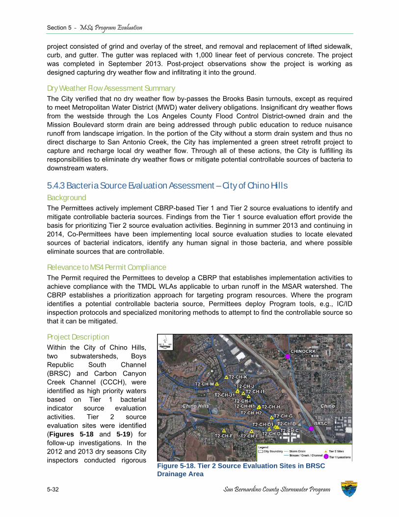
Section 5 - MS4 Program Evaluation
5-32 San Bernardino County Stormwater Program
project consisted of grind and overlay of the street, and removal and replacement of lifted sidewalk, curb, and gutter. The gutter was replaced with 1,000 linear feet of pervious concrete. The project was completed in September 2013. Post-project observations show the project is working as designed capturing dry weather flow and infiltrating it into the ground.
Dry Weather Flow Assessment Summary The City verified that no dry weather flow by-passes the Brooks Basin turnouts, except as required to meet Metropolitan Water District (MWD) water delivery obligations. Insignificant dry weather flows from the westside through the Los Angeles County Flood Control District-owned drain and the Mission Boulevard storm drain are being addressed through public education to reduce nuisance runoff from landscape irrigation. In the portion of the City without a storm drain system and thus no direct discharge to San Antonio Creek, the City has implemented a green street retrofit project to capture and recharge local dry weather flow. Through all of these actions, the City is fulfilling its responsibilities to eliminate dry weather flows or mitigate potential controllable sources of bacteria to downstream waters.
5.4.3 Bacteria Source Evaluation Assessment – City of Chino Hills Background The Permittees actively implement CBRP-based Tier 1 and Tier 2 source evaluations to identify and mitigate controllable bacteria sources. Findings from the Tier 1 source evaluation effort provide the basis for prioritizing Tier 2 source evaluation activities. Beginning in summer 2013 and continuing in 2014, Co-Permittees have been implementing local source evaluation studies to locate elevated sources of bacterial indicators, identify any human signal in those bacteria, and where possible eliminate sources that are controllable.
Relevance to MS4 Permit Compliance The Permit required the Permittees to develop a CBRP that establishes implementation activities to achieve compliance with the TMDL WLAs applicable to urban runoff in the MSAR watershed. The CBRP establishes a prioritization approach for targeting program resources. Where the program identifies a potential controllable bacteria source, Permittees deploy Program tools, e.g., IC/ID inspection protocols and specialized monitoring methods to attempt to find the controllable source so that it can be mitigated.
Project Description Within the City of Chino Hills, two subwatersheds, Boys Republic South Channel (BRSC) and Carbon Canyon Creek Channel (CCCH), were identified as high priority waters based on Tier 1 bacterial indicator source evaluation activities. Tier 2 source evaluation sites were identified (Figures 5-18 and 5-19) for follow-up investigations. In the 2012 and 2013 dry seasons City inspectors conducted rigorous
Figure 5-18. Tier 2 Source Evaluation Sites in BRSC Drainage Area

Section 5 - MS4 Program Evaluation
San Bernardino County Areawide Stormwater Program 5-33
bacteria source investigations, totaling over 400 hours of field work. Sample collection included:
♦ Collection of 86 bacterial indicator samples, indicating variable but elevated bacteria concentrations in the MS4;
♦ Collection of 37 samples for analysis of alternative human waste tracers (ammonia, methylene blue active substances, and potassium); and
♦ Collection of 27 samples for molecular source tracking to identify host organisms, including human, dog, or bird.
In addition to collection of numerous water quality samples, the Tier 2 source investigations involved numerous residential and commercial property inspections, resulting in significant opportunities for public education and outreach and mitigation actions.
Source Evaluation Findings and Mitigation Activities The methodical investigation of MS4 outfalls and the drainage system connected to those outfalls identified several specific sources of bacterial indicators. Three mitigation actions resulted from this effort:
♦ Observations of significant cliff swallow nesting activity within the BRSC culvert (Figure 5-20). The City installed netting in this culvert to inhibit these birds from continuing this nesting activity in subsequent years.
♦ Identification of a mobile fish market business that was washing off its equipment into an MS4 drain (Figure 5-21). This particular bacteria source was located by popping series of manhole covers along a storm drain line to track the source of dry weather flow within the MS4 facility.
Figure 5-19. Tier 2 Source Evaluation Sites in CCCH Drainage Area
Figure 5-20. Birds Nesting in BRSC Culvert
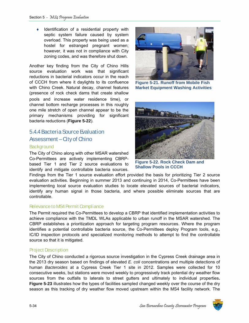
Section 5 - MS4 Program Evaluation
5-34 San Bernardino County Stormwater Program
♦ Identification of a residential property with septic system failure caused by system overload. This property was being used as a hostel for estranged pregnant women; however, it was not in compliance with City zoning codes, and was therefore shut down.
Another key finding from the City of Chino Hills source evaluation work was that significant reductions in bacterial indicators occur in the reach of CCCH from where it daylights to its confluence with Chino Creek. Natural decay, channel features (presence of rock check dams that create shallow pools and increase water residence time), or channel bottom recharge processes in this roughly one mile stretch of open channel appear to be the primary mechanisms providing for significant bacteria reductions (Figure 5-22).
5.4.4 Bacteria Source Evaluation Assessment – City of Chino Background The City of Chino along with other MSAR watershed Co-Permittees are actively implementing CBRP-based Tier 1 and Tier 2 source evaluations to identify and mitigate controllable bacteria sources. Findings from the Tier 1 source evaluation effort provided the basis for prioritizing Tier 2 source evaluation activities. Beginning in summer 2013 and continuing in 2014, Co-Permittees have been implementing local source evaluation studies to locate elevated sources of bacterial indicators, identify any human signal in those bacteria, and where possible eliminate sources that are controllable.
Relevance to MS4 Permit Compliance The Permit required the Co-Permittees to develop a CBRP that identified implementation activities to achieve compliance with the TMDL WLAs applicable to urban runoff in the MSAR watershed. The CBRP establishes a prioritization approach for targeting program resources. Where the program identifies a potential controllable bacteria source, the Co-Permittees deploy Program tools, e.g., IC/ID inspection protocols and specialized monitoring methods to attempt to find the controllable source so that it is mitigated.
Project Description The City of Chino conducted a rigorous source investigation in the Cypress Creek drainage area in the 2013 dry season based on findings of elevated E. coli concentrations and multiple detections of human Bacteroides at a Cypress Creek Tier 1 site in 2012. Samples were collected for 10 consecutive weeks, but stations were moved weekly to progressively track potential dry weather flow sources from the outfalls to laterals to street gutters and ultimately to individual properties. Figure 5-23 illustrates how the types of facilities sampled changed weekly over the course of the dry season as this tracking of dry weather flow moved upstream within the MS4 facility network. The
Figure 5-21. Runoff from Mobile Fish Market Equipment Washing Activities
Figure 5-22. Rock Check Dam and Shallow Pools in CCCH

Section 5 - MS4 Program Evaluation
San Bernardino County Areawide Stormwater Program 5-35
Figure 5-23. Weekly Distribution of Facility Types where Samples were Collected during the 2013 Dry Season Tier 2 Source Evaluation Program
Figure 5-25. Unlined Open Channel Segment of Cypress Channel
Figure 5-24. Illegal Dumping of Dog Feces nto Cypress Channel i
number of samples collected per acre of drainage area within the Cypress Creek MS4 is unprecedented in the Santa Ana River basin.
Source Evaluation Findings and Mitigation Activities During the 2013 dry season source evaluation, the City also performed reconnaissance surveys of open channels and several neighborhoods. As a result the City identified multiple instances of illegal dumping that may have caused or contributed to high bacterial indicator concentrations in the MS4. Figure 5-24 shows a section of the flood control channel where a homeowner has been dumping dog feces from the backyard over a concrete wall into the flood control right of way. The City performed outreach for each property where illegal dumping was identified and follow up surveillance has confirmed that the problems have been resolved.
E. coli concentrations at the downstream Tier 1 site met water quality objectives for all 10 weeks of the 2013 monitoring program, despite the occurrence of significant exceedances observed during the 2012 dry season. One potential explanation for the improved water quality may be the result of active IC/ID activities.
Another potential explanation for the water quality improvements is in-stream processes. Source evaluation monitoring in the 2013 dry season showed significant reductions in E. coli concentration as dry weather flow passed through the open channel segment of Cypress Channel, between Eucalyptus Avenue and Kimball Avenue (Figure 5-25). Samples from Tier 2 sites, all upstream of Eucalyptus Avenue, had a geometric mean of 1500 MPN/100 mL over the course of the dry season versus only 18 MPN/100 mL at the downstream Tier 1 site. Natural decay by ultraviolet light exposure or channel bottom recharge in the unlined
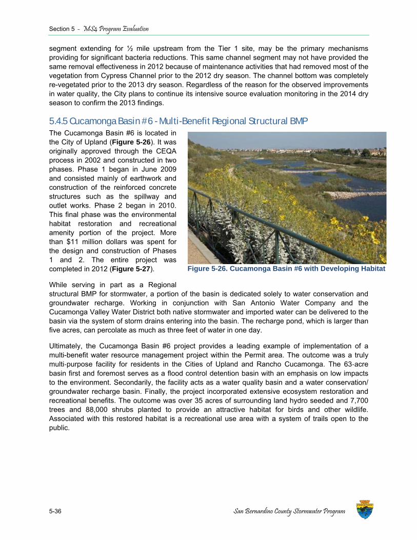
Section 5 - MS4 Program Evaluation
5-36 San Bernardino County Stormwater Program
segment extending for ½ mile upstream from the Tier 1 site, may be the primary mechanisms providing for significant bacteria reductions. This same channel segment may not have provided the same removal effectiveness in 2012 because of maintenance activities that had removed most of the vegetation from Cypress Channel prior to the 2012 dry season. The channel bottom was completely re-vegetated prior to the 2013 dry season. Regardless of the reason for the observed improvements in water quality, the City plans to continue its intensive source evaluation monitoring in the 2014 dry season to confirm the 2013 findings.
5.4.5 Cucamonga Basin #6 - Multi-Benefit Regional Structural BMP The Cucamonga Basin #6 is located in the City of Upland (Figure 5-26). It was originally approved through the CEQA process in 2002 and constructed in two phases. Phase 1 began in June 2009 and consisted mainly of earthwork and construction of the reinforced concrete structures such as the spillway and outlet works. Phase 2 began in 2010. This final phase was the environmental habitat restoration and recreational amenity portion of the project. More than $11 million dollars was spent for the design and construction of Phases 1 and 2. The entire project was completed in 2012 (Figure 5-27).
While serving in part as a Regional structural BMP for stormwater, a portion of the basin is dedicated solely to water conservation and groundwater recharge. Working in conjunction with San Antonio Water Company and the Cucamonga Valley Water District both native stormwater and imported water can be delivered to the basin via the system of storm drains entering into the basin. The recharge pond, which is larger than five acres, can percolate as much as three feet of water in one day.
Ultimately, the Cucamonga Basin #6 project provides a leading example of implementation of a multi-benefit water resource management project within the Permit area. The outcome was a truly multi‐purpose facility for residents in the Cities of Upland and Rancho Cucamonga. The 63‐acre basin first and foremost serves as a flood control detention basin with an emphasis on low impacts to the environment. Secondarily, the facility acts as a water quality basin and a water conservation/ groundwater recharge basin. Finally, the project incorporated extensive ecosystem restoration and recreational benefits. The outcome was over 35 acres of surrounding land hydro seeded and 7,700 trees and 88,000 shrubs planted to provide an attractive habitat for birds and other wildlife. Associated with this restored habitat is a recreational use area with a system of trails open to the public.
Figure 5-26. Cucamonga Basin #6 with Developing Habitat

Section 5 - MS4 Program Evaluation
San Bernardino County Areawide Stormwater Program 5-37
Figure 5-27. Conceptual Master Plan of Cucamonga Basin #6 after Completion
Figure 5-28. Location of Wildwood Creek Basin Project in Yucaipa, CA (Source: Supplemental Environmental Assessment: Wildwood Creek Detention Basins, November 2007; http://www.fema.gov/media-library-data/20130726-1622-20490-8825/yucaipa_sea.pdf )
5.4.6 Wildwood Creek Basin Project – Multi-Benefit Regional Structural BMP Project With its headwaters within the San Bernardino National Forest, Wildwood Creek has a drainage area of approximately 5,400 acres. It is one of six major surface waterbodies within the City of Yucaipa. Wildwood Creek generally flows intermittently, but can have water regularly during the wet season. Flooding and sedimentation can be problems in the City during 100-year flood events (Figure 5-28). The primary purpose of the project was to reduce sedimentation and downstream flooding along Wildwood Creek while providing opportunity for capture of stormwater and groundwater recharge. The capture and recharge of stormwater improves downstream water quality.
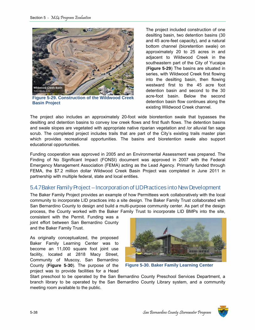
Section 5 - MS4 Program Evaluation
5-38 San Bernardino County Stormwater Program
The project included construction of one desilting basin, two detention basins (30 and 45 acre-feet capacity), and a natural bottom channel (bioretention swale) on approximately 20 to 25 acres in and adjacent to Wildwood Creek in the southeastern part of the City of Yucaipa (Figure 5-29) The basins are situated in series, with Wildwood Creek first flowing into the desilting basin, then flowing westward first to the 45 acre foot detention basin and second to the 30 acre-foot basin. Below the second detention basin flow continues along the existing Wildwood Creek channel.
The project also includes an approximately 20-foot wide bioretention swale that bypasses the desilting and detention basins to convey low creek flows and first flush flows. The detention basins and swale slopes are vegetated with appropriate native riparian vegetation and /or alluvial fan sage scrub. The completed project includes trails that are part of the City’s existing trails master plan which provides recreational opportunities. The basins and bioretention swale also support educational opportunities.
Funding cooperation was approved in 2005 and an Environmental Assessment was prepared. The Finding of No Significant Impact (FONSI) document was approved in 2007 with the Federal Emergency Management Association (FEMA) acting as the Lead Agency. Primarily funded through FEMA, the $7.2 million dollar Wildwood Creek Basin Project was completed in June 2011 in partnership with multiple federal, state and local entities.
5.4.7 Baker Family Project – Incorporation of LID Practices into New Development The Baker Family Project provides an example of how Permittees work collaboratively with the local community to incorporate LID practices into a site design. The Baker Family Trust collaborated with San Bernardino County to design and build a multi-purpose community center. As part of the design process, the County worked with the Baker Family Trust to incorporate LID BMPs into the site, consistent with the Permit. Funding was a joint effort between San Bernardino County and the Baker Family Trust.
As originally conceptualized, the proposed Baker Family Learning Center was to become an 11,000 square foot joint use facility, located at 2818 Macy Street, Community of Muscoy, San Bernardino County (Figure 5-30). The purpose of the project was to provide facilities for a Head Start preschool to be operated by the San Bernardino County Preschool Services Department, a branch library to be operated by the San Bernardino County Library system, and a community meeting room available to the public.
Figure 5-29. Construction of the Wildwood Creek Basin Project
Figure 5-30. Baker Family Learning Center
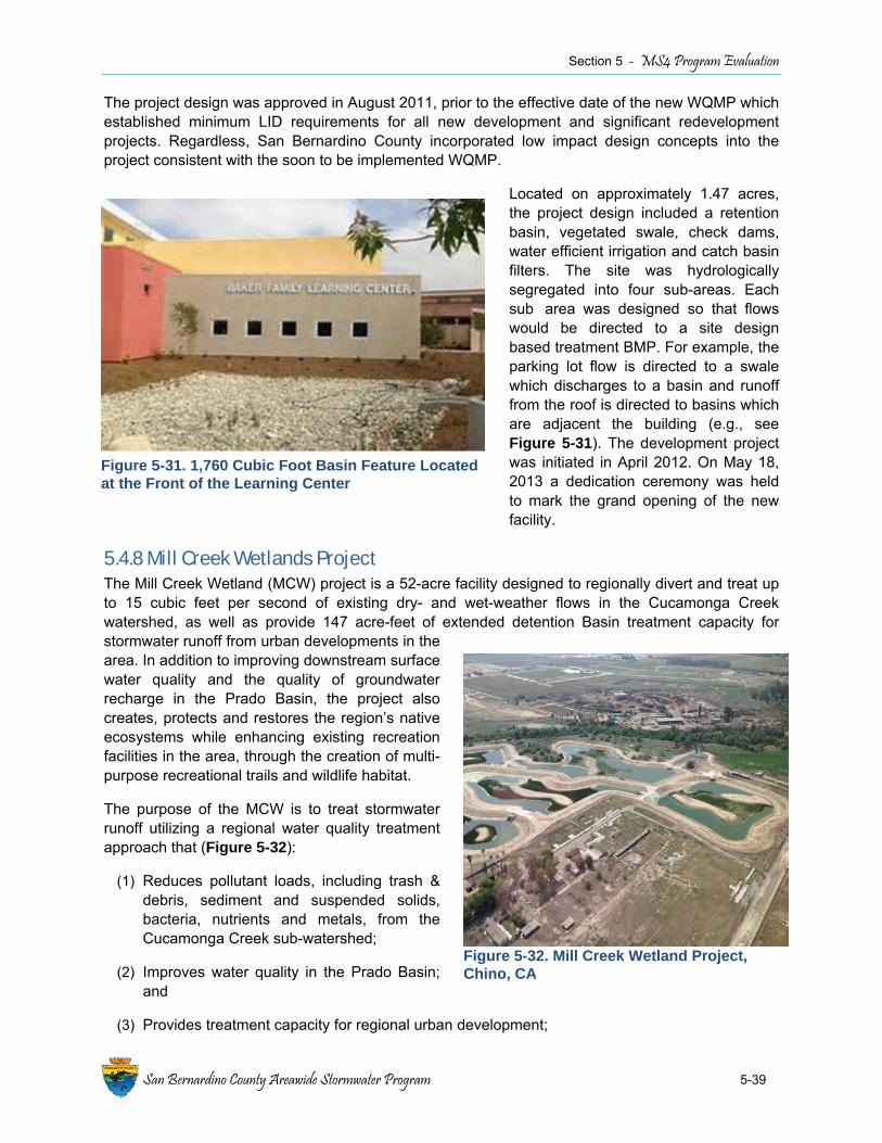
Section 5 - MS4 Program Evaluation
San Bernardino County Areawide Stormwater Program 5-39
Figure 5-31. 1,760 Cubic Foot Basin Feature Located at the Front of the Learning Center
The project design was approved in August 2011, prior to the effective date of the new WQMP which established minimum LID requirements for all new development and significant redevelopment projects. Regardless, San Bernardino County incorporated low impact design concepts into the project consistent with the soon to be implemented WQMP.
Located on approximately 1.47 acres, the project design included a retention basin, vegetated swale, check dams, water efficient irrigation and catch basin filters. The site was hydrologically segregated into four sub-areas. Each sub�area was designed so that flows would be directed to a site design based treatment BMP. For example, the parking lot flow is directed to a swale which discharges to a basin and runoff from the roof is directed to basins which are adjacent the building (e.g., see Figure 5-31). The development project was initiated in April 2012. On May 18, 2013 a dedication ceremony was held to mark the grand opening of the new facility.
5.4.8 Mill Creek Wetlands Project The Mill Creek Wetland (MCW) project is a 52-acre facility designed to regionally divert and treat up to 15 cubic feet per second of existing dry- and wet-weather flows in the Cucamonga Creek watershed, as well as provide 147 acre-feet of extended detention Basin treatment capacity for stormwater runoff from urban developments in the area. In addition to improving downstream surface water quality and the quality of groundwater recharge in the Prado Basin, the project also creates, protects and restores the region’s native ecosystems while enhancing existing recreation facilities in the area, through the creation of multi-purpose recreational trails and wildlife habitat.
The purpose of the MCW is to treat stormwater runoff utilizing a regional water quality treatment approach that (Figure 5-32):
(1) Reduces pollutant loads, including trash & debris, sediment and suspended solids, bacteria, nutrients and metals, from the Cucamonga Creek sub-watershed;
(2) Improves water quality in the Prado Basin; and
(3) Provides treatment capacity for regional urban development;
Figure 5-32. Mill Creek Wetland Project, Chino, CA
Section 5 - MS4 Program Evaluation
5-40 San Bernardino County Stormwater Program
The project consists of a diversion structure, along the western bank of Cucamonga Creek, a weir box that regulates and directs dry and wet season flows into a dual box channel, connected to a desilting basin which outlets into two sets of three wetland/extended detention treatment ponds, linked in series.
The Mill Creek Wetland Project is sponsored by the City of Ontario. The project received a $5 million grant from the State Water Board, under Proposition 13 & 40; a $1 million grant from the Department of Water Resources administered by the Santa Ana Watershed Project Authority, and a $1.5 million grant from the National Resources Agency, under Proposition 84. Matching funds from the City of Ontario were also utilized to fund the project. Development approvals included a Non-Recreation Outgrant (October 2012), a FONSI from the US Army Corps of Engineers (June 2012), CEQA and National Environmental Policy Act approvals (January 2012), 401 Certification (June 2012), 404 Permit (August 2012), 408 Permit (July 2012) and a 1602 Streambed Alteration Permit (December, 2013). Project planning and design, including permit and grant applications were initiated in June 2006. Project construction will be completed in June 2014.

San Bernardino County Areawide Stormwater Program
A-1
Attachment A
Interim Progress Evaluation for San Bernardino County - MS4 Compliance with the Middle Santa Ana River Bacterial Indicator TMDL

Attachment A Interim Progress Evaluation for San Bernardino County ‐ MS4 Compliance with the
Middle Santa Ana River Bacterial Indicator TMDL Summary Permittees named in the Bacterial Indicator TMDL for the Middle Santa Ana River (MSAR) must be in compliance with the urban Waste Load Allocation (WLA) for Dry Season conditions by the end of 2015. San Bernardino County is implementing a Comprehensive Bacteria Reduction Plan (CBRP) and expects to meet this requirement by the specified deadline. The basis for this belief is explained below. TMDL Regulatory Requirements In 2005, the Santa Ana Regional Water Quality Control Board (Regional Board) adopted a Total Maximum Daily Load (TMDL) for Bacterial Indicators in the following waterbodies:1
Santa Ana River ‐ Reach 3 Chino Creek ‐ Reach 1 Mill Creek (Prado Area) Chino Creek ‐ Reach 2 Prado Park Lakes Cucamonga Creek ‐ Reach 1
In the TMDL, the Regional Board established the following numeric target for pathogen indicator bacteria:
"E. coli: log mean less than 126 organisms /100 mL based on five or more samples per 30‐day period, and not more than 10% of the samples exceed 235 organisms/100 mL for any 30 day period."2
To achieve the numeric target, the Regional Board also approved the following WLA for bacterial indicators in urban runoff:
"5‐sample/30‐day Logarithmic Mean [must be] less than 113 [E. coli] organisms per 100 mL, and not more than 10% of the samples [may] exceed 212 organisms/100 mL for any 30‐day period."
The final compliance date for the WLA for urban runoff during Dry Season conditions (April 1 through October 31] is December 31, 2015. The final compliance date for the WLA for urban runoff during Wet Season conditions (November 1 through March 31) is December 31, 2025.3
1 R8‐2005‐0001 (Aug, 26, 2005); The TMDL was subsequently approved by the State Water Resources Control Board (State Water Board) on May 15, 2006; by the Office of Administrative Law on September 1, 2006 and the USEPA on May 16, 2007.
2 The Regional Board also established a numeric target and WLA for fecal coliform. However, this provision automatically became ineffective when the Basin Plan was amended to delete the water quality objectives for fecal coliform in June of 2012 (R8‐2012‐0001).
3 The TMDL included similar requirements and deadlines for the regulation of bacteria loads in runoff from Confined Animal Feeding Operations (CAFOs) and other agricultural discharges.
A‐1
TMDL Implementation Strategy In early 2006, a MSAR Bacterial Indicator TMDL Task Force (Task Force) was formed to coordinate all TMDL implementation activities.4 The principal purpose was to develop a water quality monitoring program to identify sources and assess progress toward compliance. That program was approved by the Regional Board in June of 2007.5 Implementation began immediately and the Task Force continues to meet quarterly to oversee the monitoring effort and to review the results. The Task Force collects and analyzes at least 175 samples each year to evaluate bacterial indicator levels at the five designated compliance stations. Two reports, one summarizing results for the Dry Season and the other summarizing results for the Wet Season, are submitted annually to the Regional Board.6 The Task Force also initiated a large‐scale Urban Source Evaluation Plan (USEP) to ascertain the source of bacteria loads discharged to the lakes and streams named in the TMDL. In addition to the five designated compliance sites, water quality samples were collected at 13 additional tributary stations throughout 2007 and 2008.The resulting data (which were reported to the Regional Board7) were used to develop a risk‐based ranking system to guide all future source identification efforts. In January of 2010, the Regional Board re‐issued the Municipal Separate Storm Sewer System (MS4) NPDES permit for the Santa Ana Region of San Bernardino County.8 The permit required the Area‐wide Stormwater Management Program to comply with the TMDL by developing and implementing a Comprehensive Bacteria Reduction Plan (CBRP). The CBRP was approved by the Regional Board in February 2012.9 The CBRP set forth a rigorous water quality monitoring and evaluation process to reduce significant sources of bacterial indicators in urban runoff. Particular emphasis is placed on identifying and eliminating high‐risk human pathogen sources through the use of molecular DNA analysis. The monitoring data are used to direct Best Management Practices (BMPs) and other remediation strategies throughout the watershed. The NPDES permits also require the Permittees named in the TMDL to summarize their implementation efforts and progress toward compliance in a report submitted to the Regional Board every 3 years. The most recent report was submitted in February 2013.10
4 Members include all of the MS4 Permittees in both Riverside and San Bernardino counties that were named in the TMDL and representatives from the dairy industry and irrigated agriculture community. The Task Force is administered by SAWPA.
5 R8‐2007‐0046 (June 29, 2007). 6 Annual reports can be downloaded under the Monitoring tab at: http://www.sawpa.org/collaboration/projects/tmdl‐taskforce/
7 CDM. Middle Santa Ana River Bacterial Indicator TMDL Data Analysis Report. March 19, 2009. 8 R8‐2010‐0036 (NPDES No. CAS618036); January 29, 2010. 9 R8‐2012‐0016 (CBRP applicable to San Bernardino County); February 10, 2012. 10 CDM Smith. Middle Santa Ana River Bacterial Indicator TMDL Implementation Report. February 2013.
A‐2

Basin Plan Amendments In June of 2012, the Regional Board adopted several amendments to the Basin Plan for the Santa Ana Region that directly affect implementation requirements for the MSAR Bacterial Indicator TMDL.11 Specifically, the Basin Plan amendments made the following key changes:
1) Established a new numeric water quality objective for E. coli in REC1 waters. 2) Established a new narrative water quality objective for human pathogens. 3) Deleted the fecal coliform objectives for freshwaters designated REC1 or REC2. 4) Temporarily suspends REC1 & REC2 standards in certain high flow conditions. 5) Established new procedures to prevent water quality degradation by bacteria. 6) Removed the REC1 & REC2 use designations from Cucamonga Creek ‐ Reach 1
The Basin Plan amendments were the result of a long‐term cooperative effort between Regional Board staff and local stakeholders. Some of the changes (such as the adoption of E. coli objectives and deletion of obsolete fecal coliform objectives) were incorporated into the TMDL and the CBRP even before adoption of the Basin Plan amendments. Other provisions in the Basin Plan amendments have not yet been fully integrated into the TMDL or the CBRP. For example, the Basin Plan affirms that some sources of bacteria (e.g., birds, wildlife, sediment, biofilms, etc.) are naturally‐occurring and cannot reasonably be controlled. The source evaluation studies conducted by the Task Force indicate that much of the remaining bacteria in local lakes and streams appear to originate from such sources. The "Load Allocation for Natural Sources" in the TMDL should be revised to reflect this new information. In addition, the TMDL recognized the important distinction between wet weather flows and dry weather flows by establishing different compliance dates for Wet and Dry Seasons. Monitoring conducted since TMDL approval in 2007 shows that, while more likely to occur in the winter, rain storms can occur at any time of year. Since the Basin Plan amendments temporarily suspend water quality standards under certain high flow conditions, regardless of the season, the TMDL should be revised accordingly. Finally, because the concrete‐lined segment of Cucamonga Creek is no longer designated for recreational uses, the bacteria standards no longer apply in Reach 1 of this stream. It is likely that Cucamonga Creek will be removed from the 303(d) list in 2016. Nevertheless, Reach 3 of the Santa Ana River is still designated REC1 and Cucamonga Creek is tributary to this segment. Therefore, the Permittees remain committed to implementing BMPs designed to meet water quality standards in the Santa Ana River by reducing controllable sources of bacteria in the urban runoff flowing from Cucamonga Creek. A large diversion/recharge project was recently completed at the county line to intercept much of the urban runoff before it flows into Reach 3.
11 R8‐2012‐0001 (June 15, 2012). Subsequently approved by State Water Board Resolution No. 2014‐0005 (January 21, 2014) and Office of Administrative Law (#2014‐0520‐02 S; July 2, 2014). Basin Plan amendments now undergoing final review and approval by USEPA.
A‐3
A‐4
TMDL Compliance Outlook The TMDL set a final compliance date of December 31, 2015 for the Dry Season (April 1 through October 31) WLA for bacterial indicators in urban runoff. The Permittees are implementing numerous projects throughout the watershed to meet this requirement. Permittee’s primary compliance strategy is focused on continuing inter‐agency assistance to Chino Basin Watermaster, IEUA and San Bernardino Municipal Water District concerning the management of the more than 110 existing retention and recharge basins throughout the watershed (Figure A‐1). These facilities are designed to capture and recharge nearly all dry weather urban runoff before it can reach any of the impaired waterbodies named in the TMDL. A recent effectiveness evaluation shows that nearly all of the dry weather urban runoff originating in San Bernardino County is already being intercepted and diverted away from Reach 3 of the Santa Ana River (Figure A‐2).12 By spring of 2016, the county expects routine monitoring data and the related source analysis studies to demonstrate that controllable sources of bacteria in urban runoff are no longer causing or contributing to any exceedances at the primary compliance monitoring sites. In the southwest corner of the County, where high groundwater in the Prado Basin Management Zone makes retention and recharge ponds less practical, the Permittees are implementing intensive source investigation programs to reduce controllable sources of bacteria in urban runoff. Preliminary results from the Chino Hills area indicate much of the bacterial load may be coming from birds and wildlife living in a nearby nature preserve. Field surveys have also identified locations where homeowners were discarding excessive pet waste directly into flood control channels adjacent to their backyards. The residents quickly corrected the problem after local authorities explained the situation. The Permittees will continue to implement long‐standing BMPs (e.g., regular street‐sweeping and restaurant inspections) designed to minimize bacteria loads in the urban environment. Permittees have local ordinances to provide better control over excess pet waste. The Permittees will continue to utilize the risk‐based source evaluation system and intensive water quality monitoring to identify and eliminate controllable sources of bacteria in urban runoff. Finally, the Program intends to remain an active sponsor and participant in the MSAR TMDL Task Force. Many, if not most, of the special studies described below will be coordinated with Riverside County and the Regional Board staff through the Task Force. In addition, beginning in Fall 2014, the MSAR TMDL Task Force will begin developing the Regional Bacteria Monitoring Program that will be used throughout the entire Santa Ana River watershed to provide better protection of freshwater recreational resources. The new regional program will rely heavily on the knowledge and experience gained from the successful Watershed‐wide Compliance Monitoring Program and the Urban Source Evaluation Program previously developed by the MSAR TMDL Task Force.
12 CDM Smith. Middle Santa Ana River Bacterial Indicator TMDL Implementation Report. February 2013 (Figure 3‐16)

Figure A‐1. Numerous Stormwater Retention/Recharge Basins Located throughout the San Bernardino County MS4 Permit Area.
A‐5

Figure A‐2. Schematic Showing Absence of Dry Weather Flows from San Bernardino County's MS4 Facilities to Reach‐3 of the Santa Ana River (Source: Figure 3‐16, CBRP TMDL Implementation Report, February 2013).
A‐6
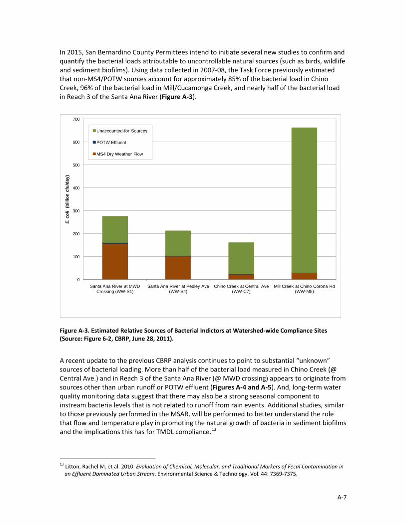
In 2015, San Bernardino County Permittees intend to initiate several new studies to confirm and quantify the bacterial loads attributable to uncontrollable natural sources (such as birds, wildlife and sediment biofilms). Using data collected in 2007‐08, the Task Force previously estimated that non‐MS4/POTW sources account for approximately 85% of the bacterial load in Chino Creek, 96% of the bacterial load in Mill/Cucamonga Creek, and nearly half of the bacterial load in Reach 3 of the Santa Ana River (Figure A‐3).
0
100
200
300
400
500
600
700
Santa Ana River at MWD Crossing (WW-S1)
Santa Ana River at Pedley Ave (WW-S4)
Chino Creek at Central Ave (WW-C7)
Mill Creek at Chino Corona Rd (WW-M5)
E. c
oli
(bill
ion
cfu/
day)
Unaccounted-for Sources
POTW Effluent
MS4 Dry Weather Flow
Figure A‐3. Estimated Relative Sources of Bacterial Indictors at Watershed‐wide Compliance Sites (Source: Figure 6‐2, CBRP, June 28, 2011).
A recent update to the previous CBRP analysis continues to point to substantial “unknown” sources of bacterial loading. More than half of the bacterial load measured in Chino Creek (@ Central Ave.) and in Reach 3 of the Santa Ana River (@ MWD crossing) appears to originate from sources other than urban runoff or POTW effluent (Figures A‐4 and A‐5). And, long‐term water quality monitoring data suggest that there may also be a strong seasonal component to instream bacteria levels that is not related to runoff from rain events. Additional studies, similar to those previously performed in the MSAR, will be performed to better understand the role that flow and temperature play in promoting the natural growth of bacteria in sediment biofilms and the implications this has for TMDL compliance.13
13 Litton, Rachel M. et al. 2010. Evaluation of Chemical, Molecular, and Traditional Markers of Fecal Contamination in an Effluent Dominated Urban Stream. Environmental Science & Technology. Vol. 44: 7369‐7375.
A‐7

Figure A‐4. Comparison of Estimated Blended E. coli Concentration of MS4 and Clean POTW Effluent with Downstream Watershed‐Wide Compliance Monitoring Data for Chino Creek at Central Avenue (Source: Figure 3‐11, CBRP TMDL Implementation Report, February 2013).
Figure A‐5. Comparison of Estimated Blended E. coli Concentration of MS4 and Clean POTW Effluent with Downstream Watershed‐Wide Compliance Monitoring Data for Santa Ana River at MWD Crossing (Source: Figure 3‐17, CBRP TMDL Implementation Report, February 2013).
A‐8