Report of the Inter-Departmental Urban-Rural Definition Group · Report of the Inter-Departmental...
48
Report of the Inter-Departmental Urban-Rural Definition Group Statistical Classification and Delineation of Settlements February 2005 A National Statistics Publication
Transcript of Report of the Inter-Departmental Urban-Rural Definition Group · Report of the Inter-Departmental...

Report of the Inter-Departmental Urban-Rural Definition Group
Statistical Classification and Delineation of SettlementsFebruary 2005
A National Statistics Publication

Northern Ireland Statistics and Research Agency
McAuley House
2-14 Castle Street
Belfast
BT1 1SA
Telephone 028 9034 8160
Fax 028 9034 8161
Website www.nisra.gov.uk
Contact point:
Uel McMath
NISRA Geography
Telephone 028 9034 8156
Fax 028 9034 8134
This is a National Statistics publication © Crown Copyright 2005
National Statistics are produced to high professional standards set out in the National Statistics Code of Practice.
They undergo regular assurance reviews to ensure that they meet customer needs.
They are produced free from any political interference.

1
Contents
Report 2
Gazetteer of settlements 6
Annex A Analysis of departmental reponses to Assembly Questions on definition of
“urban” and “rural” 21
Annex B Terms of reference of Urban-Rural Definition Group 22
Annex C Interim report and consultation 23
Annex D Urban settlement and rural areas - Background and historical perspective 28
Annex E Service function of settlements 32
Annex F Accessibility 37
Annex G Definition of settlements in terms of spatial units 38
Annex H Recent research in Great Britain 42
Glossary 44

Introduction
1. Urban and rural issues are of some considerable importance for government. TheEuropean Union pays grants for urban and rural development. Rurality is a factor inallocation of health and social care funding; housing, roads, water and sewerage andthe provision and maintenance of schools all present different issues in urban and ruralareas. Employment in rural areas has its own distinctive features, and urban and ruralleisure facilities are often quite dissimilar.
2. In Northern Ireland, there is a Department with specific responsibility for rural development,and another with responsibility for urban regeneration, whilst none of the otherDepartments can ignore the issue, as “rural-proofing” of policies is in place.
3. Although urban and rural issues are recognised as important, within government thereis an absence of any generally accepted definition of ‘urban’ and ‘rural’. Annex Asummarises departmental responses to a series of Assembly questions regarding thedefinition of ‘urban’ and ‘rural’. The Urban-Rural Definition Group was set up toexamine this issue. Annex B provides the terms of reference of the group. The grouphas undertaken a formal consultation on an interim version of this report and thispublication is the culmination of the first phase of the work. Annex C summarises theanalysis and conclusions of the interim report and the responses to the consultationon the interim report.
4. The distinction between ‘urban’ and ‘rural’ is not clear-cut. Annex D provides ahistorical perspective to the issue and discusses some conceptual issues relating tourban and rural settlements. From the outset of the research, three criteria wereidentified as relevant in ascribing urban characteristics to settlements: population size,population density and service provision. The issue of service provision is discussedin more detail in Annex E, which concludes with recommendations for further work inthis area. It was recognised that none of these criteria, in isolation, is sufficient andthat a combination of criteria are required to classify settlements.
5. In contrast rural areas are characterised more by a dispersed population, agriculturalor other extensive land use and distance from major urban centres. Annex Fdiscusses accessibility in more detail.
6. Ideally, settlements should be delineated from the study of built-up areas using largescale maps or ariel photographs. This is discussed in Annex G. For the purpose ofthis study, statutory settlement development limits provided by the DOE PlanningService as of March 2004 have been used as the best geographical delineation fordefining settlements. The naming of settlements used in this report also follows thatused by the Planning Service. It should be noted that settlement development limitsare designated by Planning Service in order to protect the character of settlementsand prevent urban sprawl into the surrounding countryside whilst providing for future
2
Statistical Classification and Delineation of Settlements - February 2005

3
development needs. Their purpose is not solely to define settlements geographically.Furthermore, Area Plans are updated and replaced through an ongoing programmeby Planning Service. Details are available on the Planning Service website(www.planningni.gov.uk).
7. Attention was focused on larger settlements with a population of 1,000 or more. Theapproximately 100 settlements so identified are very disparate in character. TheBelfast Metropolitan Urban Area (roughly 580,000 population) and Derry Urban Area(roughly 91,000 population) are plainly urban by any criterion of population size,population density or service provision. They are sufficiently different from each otherand from other settlements to warrant unique statistical classification.
8. The Group looked at one particular service provision facility namely the provision of apost office. The group ascertained that no settlement with a population of 2,250 ormore lacked a post office - one significant indicator of service function. A statisticalclassification of settlements above this limit was identified using rank-population sizeand a limited analysis of service criteria. The table and map below details the finalstatistical classification of settlements.
Table: Statistical classification of settlements
Label Name Settlement population size (2001 Census)
Band A: Belfast MetropolitanUrban Area (BMUA) c580,000
Band B: Derry Urban Area (DUA) c90,000
Band C: Large town 18,000 or more and under 75,000(outside BMUA and DUA)
Band D: Medium town 10,000 or more and under 18,000(outside BMUA and DUA)
Band E: Small town 4,500 or more and under 10,000(outside BMUA and DUA)
Band F: Intermediate settlement 2,250 or more and under 4,500(outside BMUA and DUA)
Band G: Village 1,000 or more and under 2,250(outside BMUA and DUA)
Band H: Small village, hamlet and Settlements of less than 1,000 open countryside people and open countryside
(outside BMUA and DUA)

(c) Crown Copyright Licence No: 40432
Statistical classification of settlements in Northern Ireland
9. The full final statistical classification of settlements in bands A-G is also summarisedin the attached gazetteer. Information is also presented on population and householdstatistics from the 2001 Census. More detailed 2001 Census data, presenting CensusKey Statistics for these settlements, are being published concurrently with this report.
A default urban-rural definition
10. The Group recommend that government departments and other users should considerdefining ‘urban’ and ‘rural’ areas in ways which are appropriate for different programmesand projects. Thus as an example, a settlement such as Castlederg or Keady may beeligible for certain rural programmes because such settlements provide services forrural hinterlands. However such settlements are likely to have housing or commercialareas that have urban characteristics, and therefore may also validly be eligible forcertain urban programmes. It follows that different definitions of urban and rural areappropriate on different occasions. However, the group recognises the value of acommonly agreed default definition of urban-rural, not least for the purpose of answeringgeneral queries such as estimating the number of people living in ‘urban’ or ‘rural’ areas.
4
Statistical Classification and Delineation of Settlements - February 2005

5
11. In the absence of a programme-specific definition, Bands A-E can be defined as urbanand Bands F-H as rural. This reflects the broad consensus of past departmental usagethat the divide between urban and rural lies among settlements whose populations arebetween 3,000 and 5,000. Under this definition, approximately 65 per cent of the NorthernIreland population live in urban areas and 35 per cent in rural areas. It is stressed that thisdefinition should not be used in a prescriptive way and policy-makers will need to considerthe appropriateness of settlement and urban/rural classifications to individual policies.
12. Similar reports classifying settlements in England & Wales and Scotland werepublished in 2004, including a multi-level classification of settlements. The Englandand Wales report includes an urban-rural break-point at a settlement population of10,000 people. The Scotland report includes a settlement break-point at 10,000population. Northern Ireland statistics can be presented on a common GB break-pointat the 10,000 population level. For further details of the England & Wales andScotland definitions see Annex H.
Areas for further work
13. There is limited readily available information on private sector services and employmentin settlements of different size. Data on public sector service provision is more readilyavailable through the NI Neighbourhood Statistics System www.ninis.nisra.gov.uk, butthis still requires development and analysis.
14. The Group recommends that a project be set up to estimate levels of public, private,community and voluntary sector service provision and employment availability insettlements. This would assist with the monitoring of the health of settlements inNorthern Ireland and of urban/rural development, as well as in refining urban/ruralclassifications.
15. The use made of services is not governed simply by their presence or absence. It isnecessary for users to reach those services, and for many purposes, remote areasshould be distinguished from more accessible areas. Work is ongoing in this areawithin the review of measures of spatial deprivation in Northern Ireland. The Grouprecommend that the results of this work be taken forward to provide detailed statisticson access to services at the individual settlement level, taking account of public andprivate transport availability.
16. The Group recommends that an inter-Departmental Group manage the work onservice provision and service access and when this work is completed the gazetteerof settlements should be reviewed to encompass service provision and accessibility. Itis noted that, on the basis of the recommendations in the Group’s interim report, workon service provision and access has already commenced.
17. Finally the Group notes that population and service provision change over time andthat the work should be revised and updated on a regular basis.
February 2005Inter Departmental Urban-Rural Definition Group

Statistical Classification Band A - Belfast Metropolitan Urban Area
Band A relates to Belfast Metropolitan Urban Area (BMUA) - as well as including Belfast UrbanArea, BMUA stretches around Belfast Lough to include Carrickfergus, Greenisland UrbanArea, Newtownabbey Urban Area, Holywood Urban Area, Bangor and smaller settlements inbetween. In addition, BMUA includes Carryduff and Castlereagh and Lisburn Urban Areas.
(c) Crown Copyright Licence No: 40432
Figure 1: Belfast Metropolitan Urban Area
6
Statistical Classification and Delineation of Settlements - February 2005

7
Table 1: Statistical Classification: Band A - Belfast Metropolitan Urban Area
Band Settlement Persons Household Spaces & (2001 Census) Communal
Establishments (2001 Census)
Belfast Metropolitan Urban Area
Bangor 58,368 24,858
Belfast Urban Area 276,705 119,589
Carrickfergus 27,192 11,073
Carryduff 6,564 2,433
Castlereagh Urban Area 54,636 23,289
Greenisland Urban Area 5,067 2,211
Groomsport & Crawfordsburn1 1,401 726
Helen’s Bay 1,356 579
Holywood Urban Area 12,027 4,839
Lisburn Urban Area 71,403 27,474
Milltown (Lisburn LGD) 1,356 516
NewtownabbeyUrban Area 62,022 25,008
Seahill 1,179 429
Belfast Metropolitan Urban Area Total 579,276 243,024
1 After defining settlements of at least 1,000 people, Groomsport and Crawfordsburn, each with a population ofunder 1,000 people, represent the remainder of the Belfast Metropolitan Urban Area. They have therefore beenamalgamated in this table.

Statistical Classification Band B - Derry Urban Area
Band B relates to Derry Urban Area (DUA) - as well as including the City, DUA includes theneighbouring settlements of Culmore, Newbuildings and Strathfoyle.
(c) Crown Copyright Licence No: 40432
Figure 2: Derry Urban Area
8
Statistical Classification and Delineation of Settlements - February 2005

9
Table 2: Statistical Classification: Band B - Derry Urban Area
Band Settlement Persons Household Spaces & (2001 Census) Communal
Establishments (2001 Census)
Derry Urban Area
Culmore 2,937 951
Londonderry 83,652 30,129
Newbuildings 2,496 858
Strathfoyle 1,578 582
Derry Urban Area Total 90,663 32,520

Statistical Classification Band C - Large Town
Band C relates to settlements labeled ‘Large Town’. In total there are 8 settlements in thisband in Northern Ireland. These range in population size from Craigavon Urban Area toLarne (see table). The definition of a large town is that it has a population of 18,000 peopleor more and is outside the Belfast Metropolitan and Derry Urban Areas.
(c) Crown Copyright Licence No: 40432
Figure 3: Example map given for Coleraine settlement development limit - further mapsof all large town settlement development limits are available at www.ninis.nisra.gov.uk
10
Statistical Classification and Delineation of Settlements - February 2005

11
Table 3 Statistical Classification: Band C- Large Town
Band Settlement Persons Household Spaces & (2001 Census) Communal
Establishments (2001 Census)
Large Town
Antrim 19,986 8,196
Ballymena 28,704 11,907
Craigavon Urban Area (Including Bleary) 57,651 23,718
Coleraine 24,042 9,711
Larne 18,210 8,205
Newry City* 27,300 10,314
Newtownards 27,795 11,502
Omagh 19,836 7,719
Band Total 223,524 91,272
* Officially classified as a City. The SDL for Newry City includes the settlement of Bessbrook.
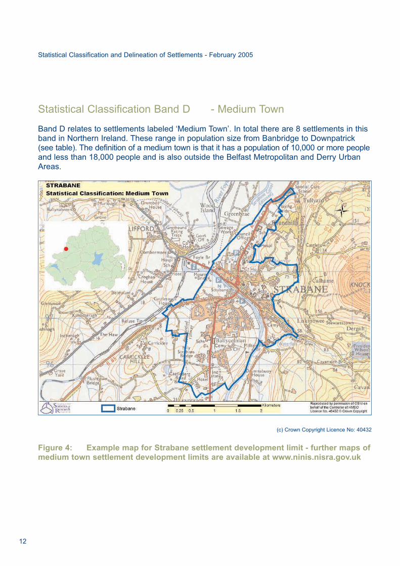
Statistical Classification Band D - Medium Town
Band D relates to settlements labeled ‘Medium Town’. In total there are 8 settlements in thisband in Northern Ireland. These range in population size from Banbridge to Downpatrick(see table). The definition of a medium town is that it has a population of 10,000 or more peopleand less than 18,000 people and is also outside the Belfast Metropolitan and Derry UrbanAreas.
(c) Crown Copyright Licence No: 40432
Figure 4: Example map for Strabane settlement development limit - further maps ofmedium town settlement development limits are available at www.ninis.nisra.gov.uk
12
Statistical Classification and Delineation of Settlements - February 2005

13
Table 4 Statistical Classification: Band D - Medium Town
Band Settlement Persons Household Spaces & (2001 Census) Communal
Establishments (2001 Census)
Medium Town
Armagh City* 14,517 5,682
Banbridge 14,748 5,838
Cookstown 10,566 4,092
Downpatrick 10,320 3,690
Dungannon 10,983 4,494
Enniskillen 13,560 5,772
Limavady 12,075 4,575
Strabane 13,380 4,632
Band Total 100,149 38,775
* Officially classified as a City.

Statistical Classification Band E - Small Town
Band E relates to settlements labeled ‘Small Town’. In total there are 15 settlements in thisband in Northern Ireland. These range in population size from Ballymoney to Coalisland (seetable). The definition of a small town is that it has a population of 4,500 or more people andless than 10,000 people and is also outside the Belfast Metropolitan and Derry Urban Areas.
(c) Crown Copyright Licence No: 40432
Figure 5: Example map of Donaghadee of settlement development limit - further mapsof small town settlement development limits are available at www.ninis.nisra.gov.uk
14
Statistical Classification and Delineation of Settlements - February 2005
15
Table 5 Statistical Classification: Band E - Small Town
Band Settlement Persons Household Spaces & (2001 Census) Communal
Establishments (2001 Census)
Small Town
Ballycastle 5,073 2,325
Ballyclare 8,772 3,624
Ballymoney 9,009 3,726
Ballynahinch 5,334 2,103
Coalisland 4,872 1,755
Comber 8,952 3,627
Donaghadee 6,474 2,955
Dromore (Banbridge LGD) 4,959 2,118
Kilkeel 6,297 2,337
Magherafelt 8,289 3,075
Newcastle 7,431 3,255
Portrush 6,345 3,249
Portstewart 7,803 4,074
Randalstown 4,944 1,863
Warrenpoint 6,981 2,742
Band Total 101,535 42,828

Statistical Classification Band F - Intermediate Settlement
Band F relates to settlements labeled ‘Intermediate Settlement’. In total there are 22settlements in this band in Northern Ireland. These range in population size from Crumlin toBroughshane (see table). The definition of an intermediate settlement is that it has apopulation of 2,250 people or more and less than 4,500 people and is also outside theBelfast Metropolitan and Derry Urban Areas.
(c) Crown Copyright Licence No: 40432
Figure 6: Example map of Broughshane settlement development limit - furthermaps of intermediate settlement - settlement development limits are available atwww.ninis.nisra.gov.uk
16
Statistical Classification and Delineation of Settlements - February 2005

17
Table 6 Statistical Classification: Band F - Intermediate Settlement
Band Settlement Persons Household Spaces & (2001 Census) Communal
Establishments (2001 Census)
Intermediate Settlement
Ahoghill 3,027 1,194
Ballygowan 2,670 951
Broughshane 2,349 969
Castlederg 2,739 1,056
Castlewellan 2,367 846
Crumlin 4,248 1,494
Cullybackey 2,388 1,062
Dungiven 2,988 1,020
Eglinton 3,150 1,107
Hillsborough 3,396 1,452
Keady 2,937 1,113
Killyleagh 2,490 1,005
Lisnaskea 2,730 1,065
Maghera 3,648 1,275
Moira 3,669 1,401
Portaferry 2,478 996
Richhill 2,808 1,035
Rostrevor 2,433 945
Saintfield 2,955 1,125
Tandragee 3,018 1,221
Waringstown 2,523 930
Whitehead 3,711 1,614
Band Total 64,722 24,876

Statistical Classification Band G - Village
Band G relates to settlements labeled ‘Village’. In total there are 48 settlements in this bandin Northern Ireland. These range in population size from Castledawson to Greyabbey (seetable). The definition of a ‘village’ settlement is that it has a population of 1,000 people or moreand is less than 2,250 people and is also outside the Belfast Metropolitan and Derry UrbanAreas.
(c) Crown Copyright Licence No: 40432
Figure 7: Example map of Bushmills settlement development limit - further maps ofall village settlement development limits are available at www.ninis.nisra.gov.uk
18
Statistical Classification and Delineation of Settlements - February 2005

19
Table 7 Statistical Classification: Band G - Village
Band Settlement Persons Household Spaces & (2001 Census) Communal
Establishments (2001 Census)
Village
Annahilt 1,131 378
Annalong 1,761 702
Ardglass 1,659 567
Ballinamallard 1,326 543
Ballykelly 1,827 627
Ballywalter 1,419 657
Bellaghy 1,071 351
Bushmills 1,314 654
Carnlough 1,440 570
Castledawson 2,085 834
Castlerock 1,326 699
Claudy 1,323 474
Cloughmills 1,224 468
Cogry/Kilbride 1,167 438
Crossgar 1,542 588
Crossmaglen 1,449 525
Cushendall 1,242 531
Doagh 1,119 480
Dollingstown 1,830 693
Draperstown 1,626 591
Dromore (Omagh LGD) 1,095 417
Drumaness 1,269 438
Dundrum 1,062 501
Dunloy 1,044 336

Table 7 Band G - Village (continued)
Band Settlement Persons Household Spaces & (2001 Census) Communal
Establishments (2001 Census)
Village
Fintona 1,344 573
Fivemiletown 1,104 483
Garvagh 1,278 498
Gilford 1,548 645
Glenavy 1,071 354
Greyabbey 1,002 441
Greysteel 1,224 429
Irvinestown 1,797 756
Kells/Connor 1,737 696
Kilrea 1,509 579
Kircubbin 1,218 477
Lisbellaw 1,041 420
Maghaberry 1,692 603
Magheralin 1,134 465
Markethill 1,290 540
Millisle 1,791 795
Moneymore 1,371 546
Moy 1,209 465
Newtownstewart 1,467 576
Portavogie 1,593 672
Portglenone 1,191 486
Rathfriland 2,061 855
Sion Mills 2,073 768
Templepatrick 1,551 612
Band Total 67,647 26,796
20
Statistical Classification and Delineation of Settlements - February 2005

21
Annex A
Analysis of Departmental responses to Assembly Questions ondefinition of “urban” and “rural”
A written assembly question to each NI Department sought to obtain the “definition of (a)urban and (b) rural used within [the] Department”. The answers supplied (given in full in theattached Schedule 1) may be summarised as follows:
None 2
Accept the definition used by other Departments 2
No standard definition, use ad hoc definitions 7
Of those seven Departments using ad hoc definitions, five specified the areas classified as urbanas follows:
DARD and DCAL Belfast Metropolitan Area, city of Derry/Londonderry, and other towns of 5,000 or more population
DoE Belfast Urban Area, Londonderry, Carrickfergus, and Bangoror towns of 3,000 or more population
DRD Urban areas of Belfast and Londonderry
DE Belfast, Derry
Thus, the only convergence between the definitions in use relates to Belfast and Derry/Londonderry as urban. There is no indication of the basis used for identifying “towns”(whether 3,000 or 5,000 population).

Annex B
Terms of reference for Urban-Rural Definition Group
1. The Urban-Rural Definition Group will make recommendations to the Statistical Co-ordinating Group on definitions of the terms ‘urban’ and ‘rural’ which are:
a. conceptually clear, coherent, and relevant to government policy in theory;
b. operationally applicable in practice; and
c. appropriate to Northern Ireland, taking account of developments elsewhere inthe British Isles and European Union
2. The Urban-Rural Definition Group will make recommendations to the Statistical Co-ordinating Group on a programme of work to:
a. identify and delineate settlements and areas of settlement;
b. collect data necessary for the application of its recommended definitions; and
c. use the data collected to classify the settlements and areas of settlementidentified and to suggest suitable uses for the classification
22
Statistical Classification and Delineation of Settlements - February 2005

23
Annex C
Interim Report and Consultation
This annex describes the conclusions of the interim report of the group that was circulatedfor consultation. The interim report can be viewed on the NISRA website atwww.nisra.gov.uk. The references to sections refer to the interim report.
The interim report noted (Section 1) that although urban and rural issues are recognised asimportant, for a variety of reasons, there is an absence of any generally accepted definitionof ‘urban’ and ‘rural’.
The report went on to describe (Section 2) how the distinction between ‘urban’ and ‘rural’ isnot clear cut. Three criteria were identified as relevant in defining towns and urbansettlements: population size, population density and service provision. None of these, inisolation, is sufficient. Rural areas are characterised by dispersal of population, imposed bythe predominant land use, and distance from urban centres.
The Group produced an initial Gazetteer of Northern Ireland settlements (Section 3),identifying 621 settlements and providing information on population (where available) andpost office provision. Population estimates were made for each settlement, based on thestatistics available at that time; these population estimates were based on informationavailable prior to the publication of results from the 2001 Census.
An initial analysis (section 4) suggested a cut off population of 2,250 since no settlementlarger than that lacked a post office. A provisional hierarchy of settlements was identified andmore detailed work confirmed that this hierarchy corresponded to population, internalstructure and transport characteristics. It was noted that the relative importance of serviceprovision by various settlements does not always correspond to the importance of thesettlements based on the hierarchy structure. Accordingly, the Group recommended in theInterim Report that Departments and other users should use the final settlement bands andsettlements in the way that best meets their needs. The degree to which the settlementbands identified can be regarded as urban varies (eg Belfast Metropolitan Area is moreurban than Small Town/village) and this should be taken into account in determining the usemade of the banding. The classification should be regarded as no more than provisional as itcurrently takes no account of private sector services, community and voluntary sectorservices, public sector services and accessibility.
The report discussed (Section 5) the provision of services, noting that there is littleinformation on private sector services and employment in settlements, but a pilotinvestigation established that there is much variation in service provision and that populationsize is not an adequate proxy for service provision. The Group recommended in the InterimReport that a project be established to examine the sources available to establish private

sector service and community/voluntary sector service provision and employment availabilityin settlements, and to produce an improved classification of services regarded asbasic/good/wide. This would assist with the monitoring of urban health and development, aswell as in refining urban/rural classifications; this project should be taken forward by an inter-departmental group.
Public sector provision also characterizes settlements, and this was described in Section 6.Accordingly, the Group recommended in the Interim Report that when an operationaldefinition of settlements is available, a project be established to use the existing GIS datasources available for establishing public sector service provision and employmentavailability. This would assist with the monitoring of urban health and development, as wellas in refining urban/rural classifications. This work should be carried forward by the groupreferred to in the paragraph above.
Section 7 describes how the utility of services is not governed simply by their presence orabsence. It is necessary for users to reach those services, and for many purposes, remoteareas should be distinguished from more accessible areas. The Group recommended in theInterim Report that a project be established to assess access to settlement services, takingaccount of public and private transport availability.
The delineation of settlements is necessary to allow full use to be made of the classification(Section 8). In line with this, the Group recommended in the Interim Report that, in view ofcurrent planning practice the Belfast Metropolitan Area (Belfast Urban Area, Bangor,Carrickfergus, Carryduff, Helen’s Bay and Crawfordsburn), and the Craigavon Urban Area(Portadown, Lurgan and Craigavon) should be regarded as two integrated settlementsdespite the fact that their component built-up areas are not contiguous.
The Group recommended in the Interim Report that its report should be given widecirculation, both inside and outside government, and that a final report is produced, takingaccount of comments received.
Consultation
The report was circulated to 70 bodies and individuals, and twelve responses were received.These responses (summarised below) were broadly supportive of the idea of view thaturban-rural was not a simple dichotomy, although there was some concern that ‘rural’ wasbeing treated as a residual category. The use of services for settlement classification waswelcomed, and a variety of points were made concerning services. Accessibility of servicesand intra-settlement variations were also noted as worthy of attention. As regards thespecific recommendations of the interim report, none of the respondents expressed anyobjection to any of them. Positive support was for the following:
24
Statistical Classification and Delineation of Settlements - February 2005

25
• Use of settlement bands appropriate to user’s needs
• Interdepartmental group to establish levels of private sector and voluntary/communityservices in settlements
• Interdepartmental group to establish levels of public sector services in settlements
• Interdepartmental group assess levels of access to services in settlements
• Acceptance of Belfast Metropolitan and Craigavon Urban Areas as fragmentedsettlements
• Delineation of settlements on postcode or other small area basis
• Widespread circulation of results
This was taken as a broad consensus among respondents on the recommendations. Therewas greatest support for flexible use of definitions; assessment of services and access tothese; and delineation of settlements on a small area basis.
Summary of responses to consultation on Interim Report
1. Individual response. The respondent expressed concern regarding circumstances ofintra-urban communities. On the subject of services, the respondent queried therelative weights used and highlighted the importance of primary schools, but acceptedthe importance of assessing the relative importance of services. The respondentnoted the decline in farming and impact of urban dwellers on rural land prices. Thestatus of settlements on the fringes of Derry and the Belfast Metropolitan area wasnoted as an issue of debate, as was the use of travel time. In subsequent correspondence,the respondent suggested that government could do little to influence or attractservice provision, although it could inhibit provision. The respondent suggested waysto assess the catchment population of various types of service through consultation,and highlighted the significance of a primary school to villages.
2. Rural Development Council. The Council was concerned at the absence of its ownmaterial from consideration by the report, and mentioned the need for a clear simpleconsultation document. It discerned an urban bias in the report, with ‘rural’ beingdefined by what it is not. Although the Council tended to agree with the report’s viewthat a single definition of urban and rural was not of practical use, it suggested thatmany in the public arena would not be satisfied with the lack of a single definition. Itmentioned functionality, natural resource use, landscape character and landownership as further factors, as well as mentioning services other than a post officeas relevant. The concept of “urban health” (and similarly, “rural health”) was useful ifbased on a wider range of services.

3. Belfast Education and Library Board. The Board suggested that any project to assessservice provision should include voluntary and statutory youth services, primary andsecondary education and libraries. The issues of neighbourhood effects within largersettlements and distance-decay should be taken into account.
4. Antrim Borough Council. The council produced a response paper, noting the overlapbetween ‘urban’ and ‘rural’, but welcoming the attempt to achieve clarity of definitionsdespite the difficulty of producing a single definition. The paper noted the possibleimpact of a reducing scale of service provision on a classification dependent on asingle service. A wide range of issues needed to be taken into account, and weighted,in any classification. The paper recommended that NISRA should undertakedelineation of settlement boundaries.
5. Lisburn City Council. The council’s consultant submitted a response on their behalf,welcoming the SCG report, and noting the importance of a single classificationsystem for planning purposes, given that the council had 38 settlements of variousclassifications. The response suggested discussion with Planning Service concerninga common approach to the proposed flexible hierarchy. It also agreed that servicesneeded to be included in urban-rural classification, although post office provision wasnot an infallible proxy. The response drew attention to the issue of resident perception,mental mapping and accessibility (including social exclusion) as ‘soft’ areas worthy ofattention.
6. Ballymoney Borough Council. The council agreed that extent of service provisionshould form part of the categorisation of services. They corrected some of the dataused by the working group and presented further information on services, which theysuggested, provided a basis for reclassification of Ballymoney as a medium ratherthan a small town.
7. Rural Community Network. The Network agreed that urban/rural formed a continuum,and argued that ‘rural’ should not be treated as a residual or purely agricultural.
8. Northern Ireland Housing Executive. NIHE accepted that a single urban-rural definitionwas not practical and welcomed work using population size, population density andservice level. They noted the need to improve and update the reports gazetteer, anddrew attention to the Planning Service typology. NIHE voiced a concern at the urbanfocus of the report, and noted the need to review the classification to take account ofchanges over time.
9. Council for Catholic Maintained Schools. The council welcomed a standardiseddelineation of settlements, noting that it viewed the Parish as a robust definition of acommunity. It suggested that 15-20 minute travel times were a useful benchmark.
26
Statistical Classification and Delineation of Settlements - February 2005

27
10. Ordnance Survey of Northern Ireland. OSNI drew attention to its function and the datathat it held, as particularly relevant to the delineation of settlements. They hold a gazetteerof 330 cities, towns and villages and are involved in the Pointer system, although theynote certain problems with the use of postcodes in settlement delineation. OSNIsuggest that the working group might wish to make contact with them.
11. Belfast City Council. The Council agreed that an overly simple urban-rural dividewould be of limited value, given the difference and within larger settlements. TheCouncil would welcome further consultation and involvement both in the initial projectand in further projects. It noted the impact of neighbourhood boundaries andsectarianism on access to services. Given the flexibility of the proposed system, thecouncil suggested that it might be useful to issue further guidance on its use.
12. South Eastern Education and Library Board. The Board tends to distinguish betweenlarger settlements (roughly medium town and larger in the Report classification). Issuesof accessibility were important and the Board suggested that the proposed researchin this area should be undertaken. A common, but flexible, definition of settlementswas welcome, and it was felt that a binary definition [of urban/rural] was unhelpful.

Annex D
Urban settlement and rural areas - Background and historical perspective
The historian S Zaluckyj1 has written
“Most people’s understanding of a town would be a settlement of such size and density ofpopulation that it drew in its surrounding population both to trade goods and also in searchof certain trades, services, businesses and specializations that were unable to exist or thrivein a sparsely populated rural area”.
However, as the historical geographer BJ Graham2 has remarked,
“It is exceptionally difficult to define ‘urban’ and further it is impossible to specify a point atwhich a settlement definitively becomes a town”.
Despite this caveat, Graham also quotes the following table, which shows a number of keycharacteristics of urban centres, as used by archaeologists, historians and geographers:
Table 1: A grouping of urban characteristics
1. Economic Market
Characteristics Central place roles
2. Social Criteria Relatively large & differentiated population in diversified employment
3. Morphological Planned street system
House plots
Defences
4. Institutional Complex religious organization
phenomena Judicial function
Mechanism of administration
28
Statistical Classification and Delineation of Settlements - February 2005
1 S Zaluckyj “Mercia, the Anglo-Saxon Kingdom of Central England” Almeley, 2001, p193
2 BJ Graham “Early Medieval Ireland c500-1100: settlement as an indicator of economic and social transformation” p29 in Ed BJ Graham & LJ Proudfoot “AnHistorical Geography of Ireland”, London, 1993

29
Urban development came comparatively late to Ireland, and urban development within Ulsterwas later than in much of Ireland. The settlements in Ulster prior to the seventeenth centuryplantation, based originally on monastic sites and Anglo-Norman administrative centres, werefew in number. Of these pre-plantation settlements, the majority have retained some significancebut plantation settlements were the more numerous. In general, it was the plantationsettlements which showed greatest growth. Of these, Belfast was the most dynamic, acquiringa regional pre-eminence that paralleled the pre-eminence of Dublin within Ireland.
Within Ulster, during the nineteenth and early twentieth centuries, urbanisation of thepopulation proceeded at a considerable pace. In 1821, 2% of the population lived in towns ofover 10,000 population (in effect, in Belfast). By 1901, the proportion was 28%, spread overa greater number of settlements, and by 1926, it was 36%.
From Table 1 above, it will be seen that the urban characteristics less easily influenced bygovernment action are economic (market and central place), social (population) andmorphological (settlement form). The location of religious and administrative functions hasalways been prone to ad hoc or even arbitrary decisions eg the location of the rankingarchdiocese of England in Canterbury rather than London in the 6th century. The followingsections consider the three more independent components of urban characterisation. Thereis also an examination of rural characterisation.
Settlement identification
The criteria on which urban settlement is identified should be clearly stated and justifiable.Three main criteria seem appropriate, in light of generally accepted approaches, and in lightof the above:
Population size (cf social criteria in Table 1).
Many definitions are based on population size, and it can be demonstrated in many areasthat there is an identifiable urban hierarchy with considerable numbers of settlementsclustered together around a limited range of typical sizes, with relatively few settlements ofintermediate size. This hierarchy can be disrupted by external events eg post World War Ipartition of Austro-Hungary or Ireland, leaving oversized settlements such as Vienna orBelfast which have been separated from part of their previous hinterland. Another cause ofdisruption to the hierarchy can be the growth of dormitory and overspill settlements (such asCarrickfergus, Bangor and Craigavon) whose true urban status is not proportionate to theirpopulation. It cannot be assumed that limits identified in one part of the world areappropriate in another.
Population density (cf morphological issues in Table 1).
In urban areas, a major land use is residence. The concentration of dwellings, dilutedsomewhat by their associated gardens, amenities and access, generate a high population

density. The exact level of that density is determined mostly by the proportion of the built-upresidential area devoted to gardens, amenities and services, rather than dwelling footage.For the most part, it is relatively easy to delineate a built-up area, but the associatedpopulation may be less easy to obtain. Care is needed, when comparing population densityfor standard units, to ensure that there are no radical differences in the proportions of non-residential land. The weakness of this approach is that the delineation of the boundary for asettlement is critical. A hamlet of four or five houses may, within its bounds, have a higherpopulation density than an upper class suburb - it is not, thereby, urban.
Service provision (cf economic characteristics in Table 1, as well as institutionalphenomena).
Provision of services has always been associated with urban areas. The presence of amarket was linked to borough status in the middle ages, with much thought being given tothe size of a reasonable catchment area. A city was defined by the presence of a cathedral.More recently, an extensive body of theory and research derived from the thinking ofChristaller seeks to identify a hierarchy of services for which service centres develop, eachwith their own catchment area. It should be noted that there is no absolute requirement for aservice centre to be a population centre. As C Dyer notes, “some rural markets ... began toresemble towns”3. Others did not. In Ireland, as in Wales, Scotland and highland parts ofEngland, it is not uncommon for services for a wide area to be provided by an isolated shop,public house or hall. Graham4 points out that English, unlike French, lacks a term for asettlement intermediate between town and village. He suggests that a very high proportionof Irish settlement fell into this intermediate category.
None of the three approaches can be regarded as satisfactory in isolation, but taken inconjunction, they tend to correct each other’s deficiencies eg a housing estate with apopulation of 5,000 but virtually no shops has only a weak claim to be regarded as anindependent town (though it may perhaps form part of a greater urban settlement) whereasa settlement with the same population but a wide range of services clearly has a muchbetter claim to be regarded as an urban settlement in its own right.
Rural areas
The above gives limited consideration to the issue of rurality, save in the negative sense of“not urban”. One way of approaching rurality is to take account of the extensive use of land.Whilst all human activities occupy some area of land, activities such as forestry and farmingare critically linked to the use of substantial areas of land. This impacts not only on the natureof the activities themselves, but also on the other land uses that are practical in the area.Where a considerable proportion of an area is taken up by extensive land use, settlement ismore diffuse, and access to public transport and other services is inevitably more limited,particularly where a minimum threshold population is required in order to make a service viable.
30
Statistical Classification and Delineation of Settlements - February 2005
3 C Dyer “Making a living in the Middle Ages: the people of Britain 850-1520”, New Haven and London, 2002, p190
4 BJ Graham “The High Middle Ages: c1100 to c1350” p82-83 in Ed BJ Graham & LJ Proudfoot “An Historical Geography of Ireland”, London, 1993

31
A rural area cannot be defined simply in terms of the proportion of the population engaged inagriculture and forestry, but must also take account of the proportion of the land surfacedevoted to these activities. Even though the majority of the population may live and work insettlements, such matters as commuting times and access to services will be conditioned bythe degree to which land use in their area is extensive rather than intensive.
Another issue is the distance to urban settlement, which not only tends to govern the type ofrural land use that occurs but also, in conjunction with the type of urban settlement, governsaccess to services and to urban employment. A rural area ten miles from an urban centre isat an advantage compared with a rural area twenty miles from a town - when the townprovides more rather than fewer services, that advantage is compounded. Anotheradvantage is almost the inverse of this, since if a rural area has easy access to a town, sothe population of the town centre has easy access to the rural area. The rural area may beable to take advantage of low land costs to compete with the town drawing shoppers andlabour to out of town shopping and industry eg freezer shops and farm butchers.
As an example, an area such as the northern part of County Down may send the majority ofits working population to Belfast, but commuting times and access to services are conditionedby the fact that the majority of the land area is devoted to farming. The population isrelatively scattered and the area does not as a whole exhibit the characteristics of a town.The level of services located within small settlements of the area can nonetheless be high.

Annex E
Service function of settlements
At the present time, availability of data on private sector services and employment withinsettlements is limited. This cannot, however, be taken as a justification for permanentlyexcluding such services from forming any part of the definition of “urban” and “rural”, for thegeneral literature assumes that service provision is a part of urban function. Populationalone is a limited basis for classification of settlements.
Pilot Study: Shop and service assessment of some County Down settlements: private sector services
Accordingly, to inform the working of the Group, a pilot classification of services wasestablished (see Schedule 1 below), with a weighting for the estimated value of individualtransactions likely to be handled by establishments. A pilot survey of establishments wascarried out in nine settlements of varying size within County Down: Downpatrick, Comber,Ballynahinch Carryduff, Ballygowan, Killyleagh, Saintfield, Ardglass and Crossgar (see Table 1 below)
No claim of definitive accuracy in numbers or categorisation can be made, but the resultshave decided indicative value. Whilst it is reasonable to assume that the catchmentpopulation required to support establishments of a given type will not vary greatly from areato area, it cannot be assumed that the catchment population is necessarily resident in thesettlements where the establishments is located. Establishments in small towns will be apt tohave low resident population available, with their custom largely drawn from outside. Largertowns will tend to have greater population per establishment, reflecting greater self-sufficiency, but a very high level of population per establishment is an indication of asettlement that directs its custom outside.
Carryduff, which on morphological grounds is part of the Belfast Metropolitan Area, is shownto have the highest levels of population per establishment provided for primary shops andservices and for consumer durable shops, whilst maintaining a moderate per capita level ofother services. This is consistent with the status of a dormitory suburb to Belfast.
32
Statistical Classification and Delineation of Settlements - February 2005

33
Tab
le 1
Serv
ice a
vailab
ilit
y i
n s
om
e C
ou
nty
Do
wn
To
wn
s
Do
wn
patr
ick
Co
mb
er
Carr
yd
uff
Ballyn
ah
inch
Ballyg
ow
an
Killy
leag
hS
ain
tfie
ldA
rdg
lass
Cro
ssg
ar
A.
Food,
Fu
el
and G
roceries
15
11
715
615
11
14
12
B.
Recre
ational
and F
ood S
erv
ices
45
27
828
81
013
12
11
C.
Oth
er
Pers
.
Serv
ices &
Consum
able
s28
30
825
77
17
112
D.
Post
Offic
e1
10
11
11
11
E.
Fin
ancia
l S
erv
ices
12
7.5
411
11
3.5
20
F.
Legal &
Com
merc
ial S
erv
ices
79
54
01
81
3
G.
Industr
ial &
Constr
uction S
erv
ices
12
12
00
31
3
H.
Consum
er
Dura
ble
s
& C
apital G
oods
H1.
Sm
all
36
10
126
14
92
3
H2.
Mediu
m11
12
211
21
14
16
H3.
Larg
e2
31
10
12
02
I. L
arg
e C
om
posite
71
14
00
00
0
To
tal
165
113.5
38
128
26
41
81.5
35
53
Po
pu
latio
n (
2001 C
en
su
s)
10320
8952
6564
5334
2670
2490
2955
1659
1542

Of the other towns examined, Downpatrick and Comber were about twice the size ofBallynahinch in population terms, four times the size of Ballygowan, Killyleagh and Saintfield,and about six times the size of Ardglass and Crossgar. In terms of total services offered,Ballynahinch, Comber, Downpatrick, and Saintfield form a discernible group, well ahead ofthe other settlements, with Ardglass and Ballygowan lying behind the remaining three. Theirranking is by no means the same as that which would be derived from population size alone.
When all types of establishment was considered, Crossgar and Saintfield consistently had arelatively low level of population per establishment, suggesting that they supply services toan outside population as well to their own. Comber and Downpatrick have relatively highpopulations per establishment for primary and other services, compared to Crossgar andSaintfield, but less markedly high for consumer durables. This suggests that for the first twocategories, these two settlements are providing services to meet their own needs rathermore than the needs of outside population, whereas for durables, the outside population ismore significant.
Of the other settlements, Ballynahinch, Ardglass and Killyleagh probably draw in externalpopulation for primary services, whereas Ballygowan probably does not. For durables,Ballynahinch draws in external population whilst the other three may well go elsewhere sincethe population per establishment is high. In regard of other services, Ballynahinch, Ballygowanand Ardglass may draw in population, whilst Killyleagh goes elsewhere.
The conclusion to be drawn from this pilot study is that a classification of the nine settlementson the basis of their service functions would be distinctly different from a classification basedon their populations. Carryduff is effectively a dormitory satellite of Belfast, rather than anurban centre. Saintfield, Crossgar and Ballynahinch support a wider range of services thanmight be expected from their resident population, by serving a more extensive catchmentarea - a classic urban function. Comber and Downpatrick provide rather more services, butthese are supported more extensively from their resident population.
Public sector service function of settlements
Public sector services are also located in settlements, and the level of provision characterizesthe settlement. Information on the location of public sector services is available throughoutNorthern Ireland. As with private/community services, it is possible to distinguish betweensettlements on the basis of the services provided, as well as on the basis of population.Once operational definitions of settlements are also available, an analysis of the servicedata, much of which is already available, would be feasible.
Accordingly, the Group recommended that when an operational definition of settlements isavailable, a project be established to use the existing GIS data sources already available forestablishing public sector service provision and employment availability. This would assistwith the monitoring of “urban health” and development, as well as in refining urban/ruralclassifications. This project should be carried forward by the Group proposed above regardingprivate sector services, as it forms a logical and simple extension of its suggested remit.
34
Statistical Classification and Delineation of Settlements - February 2005

35
At the present time, data simply are not available to take account of private sector serviceson a Northern Ireland wide basis, and so this aspect of urban function cannot form anoperational basis for settlement classification. Similarly, community and voluntary sectorservices are not adequately reflected in the classification (although it is arguable thathistorically, services which would now be classified in this manner have been a major reasonfor establishing settlements). The consequence of this, however, is that any settlementclassification in absence of such data must remain, at best, provisional.
Accordingly, the Group recommended that a project be established to examine the sourcesavailable to establish private sector and community/voluntary sector service provision andemployment availability in settlements, and to determine what level of services should beregarded as basic/good/wide. This would assist with the monitoring of “urban health” (seeGlossary) and development, as well as in refining urban/rural classifications. Such a projectshould be carried forward on an interdepartmental basis.
Schedule 1
Pilot Classification of Settlement Shops and Services
The classification is broadly in line with that suggested by the Association of Town CentreManagers. The weights are a subjective measure of the value of the transactionsundertaken in each type of establishment.
A. Food, Fuel and Groceries (Weight 10)
Includes small supermarkets, garages (counted twice if there is a garage shop), butchers,greengrocers
B. Recreational and food services (Weight 15)
Includes public houses, off licences, takeaways, restaurants, cinemas, video rentals,bookmakers
C. Personal services other than recreational, and consumable goods other than food and fuel (Weight 20)
Includes newsagents, card shops tobacconists, hairdressers, beauticians, opticians,pharmacies, travel agencies
D. Post Office (Weight 15)
E. Financial Services (Weight 50)
Includes banks, building societies, credit unions (counting ATMs as 0.5 of an outlet, inaddition to banks)

F. Legal and Commercial Services (Weight 500)
Includes solicitors, estate agents, design, IT software
G. Industrial and Construction Services (Weight 500)
Includes builders’ yards, DIY, builders, heating engineers
H. Capital goods and consumer durables
1. Generally valued up to £100 (Weight 50)
2. Generally valued over £100 but under £1000 (Weight 600)
3. Generally valued over £1000 (Weight 2000)
I. Large Composite (Weight 75)
Larger establishments carrying out a range of functions. Includes department stores andlarge supermarkets
36
Statistical Classification and Delineation of Settlements - February 2005

37
Annex F
Accessibility
As noted elsewhere in this report (Annex E), a major aspect of an urban settlement is theservices that it provides. A key issue of this is accessibility and this section examines thisissue. Excellent services are of limited value if the user cannot conveniently reach them, andthe Scottish classification of settlements recognizes this by incorporating travel times tolarger settlements.
In England and Wales the Office for National Statistics, in defining survey respondents’ localareas, currently do so using a travel time on foot of 15 to 20 minutes or an equivalent(shorter) travel time by car, but it is not possible for all services to lie within the local area.Studies in the United States show that the usage of public libraries drops notably beyondthis limit. The Post Office seems to have adopted approximately such a limit.
The furthest legally acceptable distance for travel to an English market in the middle ages,when adjusted to take account of modern transport technology (modern-medieval equivalent),corresponds to about 15 minutes travel time by car. In practice, users of service do not alwaysdemand the full improvement in access times that might be expected given the improvementin modern technology, but nonetheless, a travel time much in excess of 15 minutes isdefinitely indicative of relative inconvenience and deprivation. The Association of TownCentre Managers suggests that 20 minutes travel be considered the limit for a catchmentarea. On this basis, the Scottish criterion of remoteness, 30 minutes travel, would beperhaps quite severe. There is a need to assess the ease of access to services.
This is not simply a matter of examining travel times by road. It should be borne in mind thatcar users are independent - able to travel at their own time, by their own route. However,substantial numbers of people do not use a car and lack such freedom. In assessing theaccessibility of services, account must be taken of public transport provision. By way ofillustration, social security regulations exempt claimants from attendance to sign on at abenefit office, where the travel time involved is in excess of one hour in each direction. InFermanagh, a great many claimants avail themselves of this exemption - although no part ofFermanagh would be outside this travel time by car, many parts are by public transport.
Examining travel times to services by road and then adjusting for the impact of publictransport services on accessibility is important in determining the effective remoteness ofrural areas and small settlements, which are dependent on other, larger, settlements for theirservices. This impacts on the classification of settlements and the Group thereforerecommended that a project be established to assess access to settlement services for thepopulation of Northern Ireland, taking account of the location of these services and themeans of transport available.
In the circumstances of Northern Ireland, however, travel times are not always the mostimportant issue in an intra-settlement context. Neighbourhood effects are likely in largersettlements. These are sometimes sectarian in nature, the geography of retail andconsumption can be less to do with distance and more to do with avoidance strategies.

Annex G
Definition of settlements in terms of spatial units
Ideally, settlements should be delineated from the study of built-up areas using large scale
maps or aerial or satellite photographs. Unfortunately, this is a very resource intensive
process and the other relevant data on the settlement are often held in a form that is not
easily related to the mapped form of the settlement.
This means that it is necessary to delineate settlements in terms of spatial units that are
readily available, seeking a balance between number and availability of data on one hand
(larger units are better) and precision of delineation on the other (smaller units are better).
Spatial units available include districts, wards, Census Output Areas, postcode units and grid
squares, with Census Output Areas currently the smallest unit with mapped boundaries.
Ultimately, the group took advantage of the statutory settlement development limits (SDLs)
maintained by the Planning Service of the Department of the Environment as the best
geographical limit for defining the geographical extent of settlements. The SDLs are subject
to ongoing review by the Planning Service and the versions used in this report refer to those
in place in March 2004. The exact sources of the SDLs used in this report are given the
table below.
Settlement Development Limits
in Council Area: Source (Area Plan)
Antrim Borough Antrim Area Plan 1984-2001
& Alteration No.1 1991
Ards Borough North Down & Ards Area Plan 1984-1995
Armagh City & District Armagh Area Plan 2004, & Armagh Area Plan 2004
Alteration No: 1 Armagh Countryside Proposals
Ballymena Borough Ballymena Area Plan 1986-2001
Ballymoney Borough North East Area Plan 2002
Banbridge District Banbridge Area Plan 1983-1998, Banbridge
District Rural Area Subject Plan 1986-1998
Belfast City Belfast Urban Area Plan 2001
Carrickfergus Borough Carrickfergus Area Plan 2001
38
Statistical Classification and Delineation of Settlements - February 2005

39
Settlement Development Limits in Council Area: Source (Area Plan)
Castlereagh Borough Belfast Urban Area Plan 2001
Coleraine Borough North East Area Plan 2002
Cookstown District * East Tyrone Area Plan 1974-1994
Craigavon Borough * Craigavon Area Plan 2010 - Draft Plan
Derry City Derry Area Plan 2011
Down District Down Area Plan 1986
Dungannon & South Tyrone Borough East Tyrone Area Plan 1974-1994
Fermanagh District Fermanagh Area Plan 2007
Larne Borough Larne Area Plan 2010
Limavady Borough Limavady Area Plan 1984-1999
Lisburn City Lisburn Area Plan 2001
Magherafelt District Magherafelt Area Plan 1976-1996
Moyle District North East Area Plan 2002
Newry & Mourne District Newry Area Plan 1984-1999, Newry & Mourne Area Subject Plan 1986-1999, Mourne Area Plan 1984-1999
Newtownabbey Borough Newtownabbey Area Plan 2005
North Down Borough North Down & Ards Area Plan 1984-1995
Omagh District Omagh Area Plan 1987-2002
Strabane District Strabane Area Plan 1986-2001
* It should be noted that the following two Area Plan adoptions (Cookstown Area Plan 2010and Craigavon Area Plan 2010) were published in Summer 2004 and their currentsettlement development limits will differ from those used in this study.

The SDL boundaries are held by the Planning Service in the form of digitized files. Theseboundaries can be viewed on NISRA’s Northern Ireland Neighbourhood Information Service(NINIS) at www.ninis.nisra.gov.uk against map backgrounds. This will enable users to gaugethe geographic extent of the settlements. Examples of these maps are provided in thegazetteer within this report.
The SDL boundaries were mapped against the 2001 Census database and population andhousehold counts from the 2001 Census determined. These Census statistics are includedin the gazetteer contained within this report. All counts have been rounded as a precautionagainst possible disclosure.
Census Office, NISRA, is also making a wider range of statistical information on settlements,based on the 2001 Census, available simultaneously. For further detail, see www.nisra.gov.uk.For disclosure reasons, these further statistics are based on 100 metre grid-squareapproximations to the SDLs. Accordingly, the Census population and household countsprovided in the gazetteer do not match exactly the population and household counts in thefurther Census publication. For further detail on this, contact NISRA.
Discontinuous Settlements
The general assumption is that the definition of settlements should result in the identificationof contiguous “built-up” areas. In practice, this is difficult, since the scale of delineation hasan impact e.g. within a residential plot, only house, garage and sheds are actually built-up,whilst the garden and grounds are not - it is a matter of judgment as to when the latter aresufficiently extensive and distinct from the former to warrant separate treatment.
At the settlement level, it is quite common within a settlement to identify enclaves,particularly recreational areas, which are not built-up. Conversely, there may be built-upexclaves, such as shopping centres and small housing estates, which are not functionallyseparate from the settlement, even though they are not physically contiguous. Again, ameasure of judgment is needed in delineation, in order to avoid misleading over-precision.
There can also be problems above settlement level, where one settlement has grownoutwards to absorb other settlements. Even at the extreme of this process, where theexpanding settlement has become physically contiguous with the smaller settlement, theremay still be a community sentiment sufficient to mark out the smaller settlement as morethan a part of the greater settlement. This is particularly the case where the area of thecombined settlement exceeds the “local area” of residents.
Before this stage, however, there may be clear evidence that the smaller settlement hasbecome a clear functional part of the greater. Such evidence would include large-scalecommuting to the greater settlement, not only for work but also for shopping and services,with an accompanying absence or decline of shopping/service facilities within the smallersettlement. A rigid insistence on treating such satellite settlements as independent will result
40
Statistical Classification and Delineation of Settlements - February 2005

41
in poor planning decisions. It is for this reason that DRD and DOE have treated Bangor andCarrickfergus as part of the Belfast Metropolitan Urban Area (BMUA).
The Urban-Rural Group have taken their lead from the definitions used by the DOE and,accordingly, have used, for example, the DOE definition of the Belfast Metropolitan UrbanArea and similarly for the Derry Urban Area and the Craigavon Urban Area. Within these,separate settlements (such as Carryduff) and settlement areas (such as Lisburn Urban Area)have been identified separately.

Annex H
Recent research in Great Britain
Similar reports classifying settlements in England and Wales and Scotland were published in2004, including a multi-level classification of settlements. The classifications are summarisedbelow:
England and Wales
In England and Wales the Office for the Deputy Prime Minister (ODPM) has recentlypublished a report on urban and rural definitions5. The Rural and Urban Area Classification isa product of a joint project to produce a single and consistent classification of urban andrural areas. The project was sponsored by the Countryside Agency (CA), the Department forEnvironment, Food and Rural Affairs (Defra), Office for National Statistics (ONS), the Officeof the Deputy Prime Minister (ODPM) and the Welsh Assembly Government. A consortiumconsisting of South East Regional Research Laboratory (SERRL) at Birkbeck College andthe Department of Town and Regional Planning at University of Sheffield carried out theresearch. A summary of the definition is given in the table below.
Band Settlement definition (2004) Urban/ Rural
Urban Areas Settlements with a populationof 10,000 or more people Urban
Rural Areas
a. Small Town Identified using population densities of 1 hectareb. Village grid-squares of settlements wth a population lessc. Hamlets and Dispersed than 10,000 people and open countryside Rural
The England and Wales report includes an urban-rural break-point at a settlement populationof 10,000 people. Northern Ireland classification statistics can be presented on a commonstandard to the England and Wales definition at the 10,000 population break-point.
42
Statistical Classification and Delineation of Settlements - February 2005
5 “A Review of Urban and Rural Area Definitions: Project Report” available from the Office for National Statistics website -http://www.statistics.gov.uk/geography/downloads/Project%20Report_22%20AugONS.pdf
43
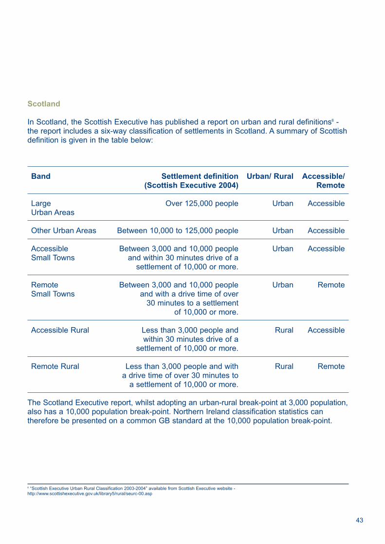
Scotland
In Scotland, the Scottish Executive has published a report on urban and rural definitions6 -the report includes a six-way classification of settlements in Scotland. A summary of Scottishdefinition is given in the table below:
Band Settlement definition Urban/ Rural Accessible/ (Scottish Executive 2004) Remote
Large Over 125,000 people Urban AccessibleUrban Areas
Other Urban Areas Between 10,000 to 125,000 people Urban Accessible
Accessible Between 3,000 and 10,000 people Urban AccessibleSmall Towns and within 30 minutes drive of a
settlement of 10,000 or more.
Remote Between 3,000 and 10,000 people Urban RemoteSmall Towns and with a drive time of over
30 minutes to a settlement of 10,000 or more.
Accessible Rural Less than 3,000 people and Rural Accessiblewithin 30 minutes drive of a
settlement of 10,000 or more.
Remote Rural Less than 3,000 people and with Rural Remotea drive time of over 30 minutes to
a settlement of 10,000 or more.
The Scotland Executive report, whilst adopting an urban-rural break-point at 3,000 population,also has a 10,000 population break-point. Northern Ireland classification statistics cantherefore be presented on a common GB standard at the 10,000 population break-point.
6 “Scottish Executive Urban Rural Classification 2003-2004” available from Scottish Executive website - http://www.scottishexecutive.gov.uk/library5/rural/seurc-00.asp

Glossary
Contiguous Settlement A settlement whose built up area is not fragmented.
Discontiguous settlement A settlement whose built up area is fragmented, although itappears to be functioning as a single unit.
Dormitory settlement A settlement whose principal function is to provide homes for peoplewho commute to work elsewhere. The range of shops and services available tends to belimited as they are competing with shops and services in the area of the workplace.
Local area The area which lies approximately 15-20 minutes travel time on foot around aperson’s home.
Modern-Medieval Equivalent The modern travel time that is equivalent to the distanceconsidered reasonable for travel to a market town in the medieval period, adjusted to takeaccount of improved modern technology. It is very similar (15-20 minutes) to operationaldefinitions adopted by service providers.
Secondary Service Centre In larger settlements, it is usual to find clusters of shops andservices in outlying parts, for the convenience of residents who do not wish to travel into thetown centre.
Topography The study or detailed description of the surface features of a region (such as asettlement)
Town Centre Most settlements have their principal concentration of shops and services inthe centre, maximizing ease of access for the residents.
Urban Health The degree to which a settlement can be considered flourishing, takingaccount of the level of services and employment available in the settlement; the number,quality and state of repair of physical facilities located in the settlement; and the socialconditions and social capital of the inhabitants of the settlement, including such factors suchas the level of crime, nuisance, noise, sectarianism.
44
Statistical Classification and Delineation of Settlements - February 2005


NISRAMcAuley House2-14 Castle StreetBelfast BT1 1SA
Telephone Fax028 9034 8160 028 9034 8161
www.nisra.gov.uk
ISBN 999903685-6