Report of Kenya visit - Edensysedensys.co.ke/pdfs/case study.pdfGlobal Ecology Institute Report of...
29
Global Ecology Institute Report of Kenya visit Goal of the visit Review of Watershed Management Plan of the Muvitha Kathemboni watershed Table of content Summary Places and issues assessed during the Kitui visit Sustainable Water Management as the basis for rural and urban plannin Description of ecological and hydrological situation of the watershed Landscape restoration Recommendations Proposal for long term engagement, models and regenerative water management Education programs for sustainable and community based infrastructure and land use Links Photos
Transcript of Report of Kenya visit - Edensysedensys.co.ke/pdfs/case study.pdfGlobal Ecology Institute Report of...

Global Ecology Institute
Report of Kenya visit
Goal of the visit
Review of Watershed Management Plan of the Muvitha Kathemboni watershed
Table of content
SummaryPlaces and issues assessed during the Kitui visitSustainable Water Management as the basis for rural and urban planninDescription of ecological and hydrological situation of the watershedLandscape restorationRecommendationsProposal for long term engagement, models and regenerative water managementEducation programs for sustainable and community based infrastructure and land useLinksPhotos
Summary
The current land-use within the catchment of the Musosya dam has lead to a fullsiltation of the dam over the last 10 years. This means that the local populationcurrently does not have access to water from the dam. The first step that has to betaken is to change the land-use. We recommend to form a watershed communityinvolving all stakeholders. In each parts of the catchment different measures have tobe taken for restoring the catchment. As a general line we recommend to increasevegetation cover so that all earth is covered and rooted. To achieve this we proposea common livestock grazing management. In addition mainly small earth worksshould be undertaken, which are already widely known by the community members.On the slopes the natural bushland/forest vegetation should be restored. We proposeto build an open well in the silted dam to get water accesses. Furthermore other wellsshould be constructed in the valleys for decentralized access to water.
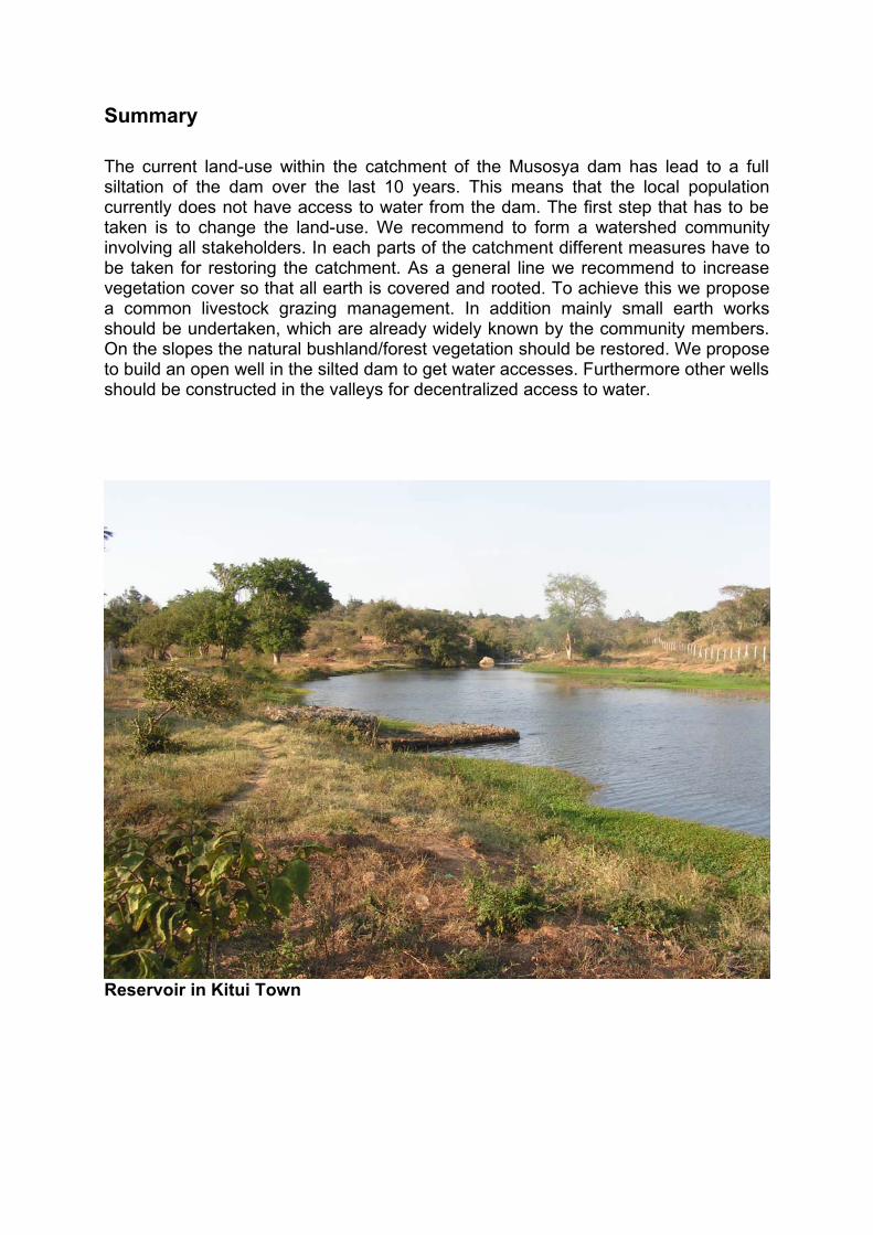
Reservoir in Kitui Town

Places and issues assessed during the Kitui visit
31.08.2013 Kitui Town
Arrival in Kitui town Study of Rainwater Harvesting techniques and agriculture practices Visit of earth dam near Kitui town Piped and hand fetched (potable) water supply of Kitui town
01.09.2013 Kitui Town
Study of rainwater harvesting techniques and agriculture practices Waste water infrastructure of Kitui town Dried up riverbeds around Kitui town Visit of unfinished building site of concrete dam
02.09.2013 Kitui Town, Nthongoni, Kitui County
Field trip to Muvitha Kathemboni Watershed Assessment of silted Musosya earth dam Study of earth work like terraces and swales
03.09.2013 Nthongoni, Kitui County
Determination of watershed size Erosion on roads Influence of animal traffic and grazing Study of grassland vegetation, Insecure agriculture production due to regular floods Deforestation
04.09.2013 Kitui town
Review field visits Mapping of watershed Vegetation cover, mulch, grazing, maps
05.09.2013 Nthongoni, Kitui County
Sand Dam Wells Upper Catchment
06.09.2013 Nthongoni, Kitui County, Kitui town
Retention ponds along road site Meeting with watershed community members

Sustainable Water Management as the basis for rural and urbanplanning
Introduction to the principles of a Water Retention Landscape
Desertification, droughts and floods have a common reason: the damage of thehydrological balance by deforestation, industrial agriculture and sealed surfaces inurban areas. Naked soil becomes hot and looses the ability to absorb water. Rainerodes the topsoil. The earth body dries out, global groundwater reserves and soilfertility decreases. For food sovereignty we need a proper water balance.A Water Retention Landscape is a model for natural and decentralized watermanagement and restoration of damaged ecosystems. It is a basis for reforestation,horticulture and agriculture in regions threatened by desertification, and is part of acomprehensive model for sustainability on a large scale including water, food, energyand community building.
In short the basic principles of the Water Retention Landscape are:
No rainwater should run over the earth surface but rather be infiltrated into the soilwhere it falls. Taking a certain territory into the focus the goal would be that no morerainwater and waste water leaves the territory but rather all water flowing awaycomes from springs.If the aquifer is recharged water is available from springs and from wells in sufficientquantities for all human usage. In most cases the soil and the earth body is notcapable to infiltrate the rainwater immediately due to mismanagement. Thereforedifferent methods are applied within the Water Retention Landscape to restore thewater balance. This includes: building of retention reservoirs (ponds, earth and sanddams), terraces, low proportion of sealed surfaces, road water infiltration, swales,permanent vegetation cover, mulching, adequate grazing management,afforestation…If the principles are understood and integrated in the planning and management,water is available all through the year, erosion is stopped, landslides are avoided,vegetation grows vigorously, rivers are constantly flowing, floods are moderate, riskof fire is low, decentralized biological agricultures enables local food security…Therefore we stress the importance of sustainable water management. In countrieswhich have a low development of infrastructure there is a large potential toimplement it in the right manner and not repeating the mistakes of the past andcurrent management.
A detailed description of the Water Retention Landscape is published in the brochure“The Secret of Water” by Bernd Walter Mueller:http://www.tamera.org/fileadmin/PDF/2.2_The_Secret_of_Water.pdf

Description of ecological and hydrological situation of thewatershed
The Muvitha Kathemboni Watershed area is a typical site in the western part of theKitui Province.The catchment has a size of approx 300 ha; the upper part is situated on a plateauon around 1140 mamsl, while the dam is situated at around 1010 mamsl. The flatplateau area is mainly used for agriculture and grazing around the family settlements.At the edge of the plateau steep to medium steep slopes descend which are mainlystocked with natural trees and bushes. Also some terraced parts occur and most ofthis bushland is grazed. In the lower parts of the catchment the inclination is softerand much land is terraced for agriculture use. Here houses of the landowners,infrastructure for livestock and grazing areas are situated.There is access from a larger public road to the plateau area, and a smaller earthroad leads to the dam area. A partly very steep earth road runs downhill from theplateau to the dam area.All land is in private ownership, except the dam area which is public. There arearound 30 private owned territories in the watershed area.The annual rainfall for the area is not precisely known, values range from 300-1000mm/y. The map shows a satellite image of the area with estimated watershed borders (page7).The area shows serious degradation of vegetation and soil. Everywhere erosionoccurs as a result of heavy rainwater runoff. Small and large gullies have formed andthe eroded material has silted the dam within the short period of 10 years. Thevegetation cover of the soil is very little, often the ground is bare. The missinganchoring roots and the compacted soils lead to low infiltration and massive runoff.
The main factors for this ongoing degradation process can be summarized by:
Low vegetation cover and low soil vitality
The main interlinked factors of the land-use techniques are:
Low vegetation cover on agriculture terraces (during dry season) Unmanaged grazing, animal trampling Deforestation for charcoal production, clay brick production and domestic use
All of these land-use methods lead to high erosion
Low infiltration leads to high runoff Unstable soil conditions by lack of vegetation and roots Roads and pathways produce high runoff… Compacted soils (livestock) Gullies Siltation of dam
Therefore the goal should be the full restoration of the catchment area. Soiland water conservation must work hand in hand to stop the process ofdegradation and lead to a regenerative state of the catchment.
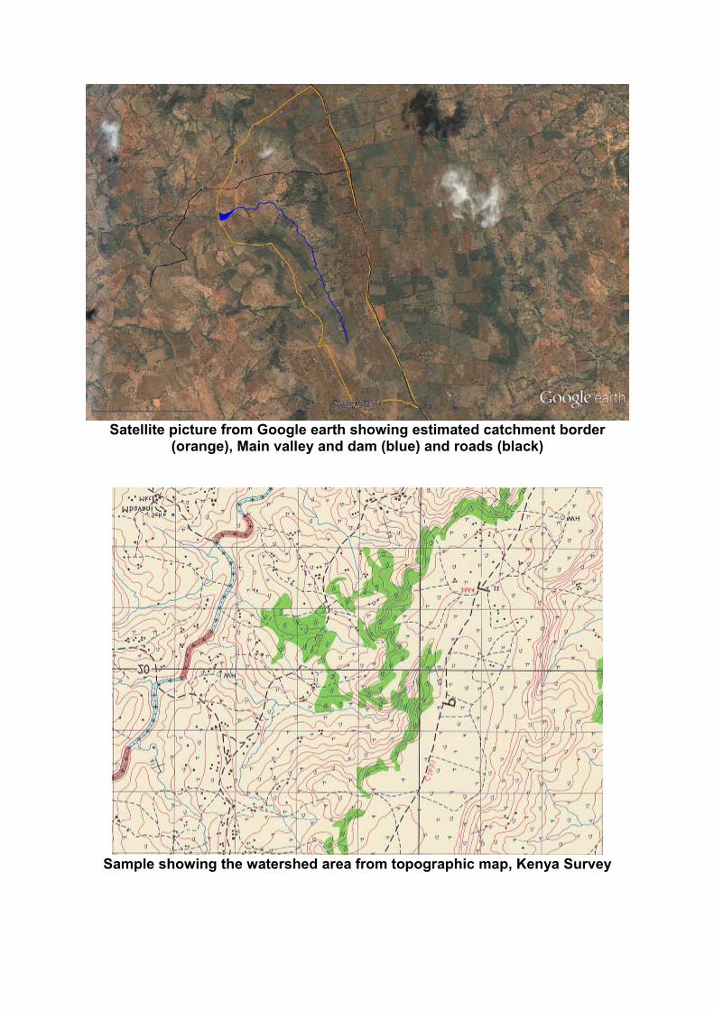
Satellite picture from Google earth showing estimated catchment border(orange), Main valley and dam (blue) and roads (black)
Sample showing the watershed area from topographic map, Kenya Survey

Landscape restoration
We emphasize that the main goal is landscape restoration for the whole catchment tosecure water supply and livelihood from agriculture and other natural resources. Thiscan only be achieved if all owners participate in a watershed managementcommittee.We propose to formulate goals on which the landowners communally agree, like:
Zero runoff of rainwater (full infiltration of rainwater to recharge the aquifer) Permanent vegetation covers of the soil Permanent running watercourses in main valley Decentralized drinking water access: Wells close to the valleys and the
settlements
To restore the dam reservoir (by removing the silted material) before avoiding furthererosion is not sustainable. The general proposal is to redirect the work and training tothe other proposed measures. In addition we want to emphasize some points that have not been addressed inaccordance to their significance. This is the role of vegetation cover, livestockmanagement and the maintenance and use of roads and pathways for a fullinfiltration and recharge of the aquifer.
During the field visits of the consultation we reviewed the proposed measures for soiland water conservation, mainly aiming in the prevention of erosion.
Recharge of aquifer
With regard to hydrology the main goal of the restoration of the watershed is therecharge of the (upper) aquifer. The rainwater is retained (not stored) in the soil androck of the whole catchment area. After a period of water saturating the upper soillayers and first rock layers the aquifer will refill. This allows extraction of water all theyear through from wells in a depth of around 2 -5 meters. Plant and tree growth isprolonged over the dry periods and irrigation becomes possible.Retaining water in earth dams or sand dams are good means if the soil and earthbody can not hold the water during the restoration phase. In the long run the largestand best retention space is the soil and the different layers of the aquifer. The nowdried out water flows and river will start to flow permanently again if the soil isrecharged with rainwater.
Vegetation
A large part of the area shows very little vegetation and/or leaf cover (living or deadmulch). Farming on terraces without cover crops as well as terrace or bench slopeswithout vegetation is one reason. Another is a continuous deforestation for fuel uses.Livestock is probably the strongest factor. Grazing of animals as well as trampling anaccess paths to water sources with animals result in many areas with bare ground. Asustainable livestock management seems to be the key to a successful restoration.
Livestock management
The watershed needs a grazing management plan. This should include the areas forgrazing, either privately or communally. Especially the roads and pathways to thesettlements and the water sources should be carefully designed. The main accessroad show strong influence of animal trampling which results in bare and compactedsoil. This leads to further erosion and destruction of the terraced land. The steepslopes should be managed to allow natural vegetation growth. Grazing rhythmswhich support the natural dynamic of this bush and grassland may be applied. Heavyand unmanaged grazing without rotation leads to high runoff which the lower part ofthe catchment can not cope with.There are numerous grazing management approaches known in eastern Africa.We strongly recommend taking local consultation and training for the involvedlandowners.
Earth works
Smaller structuresDifferent methods are proposed and already applied in the project. Farmers aretrained in terracing, infiltration ditches (swales), stone berms…All this solutions are suitable to infiltrate water thereby reduce runoff and erosion.And these methods are already applied and culturally accepted in the area. Nevertheless they can only be of sustainable value if combined with permanentvegetation cover.
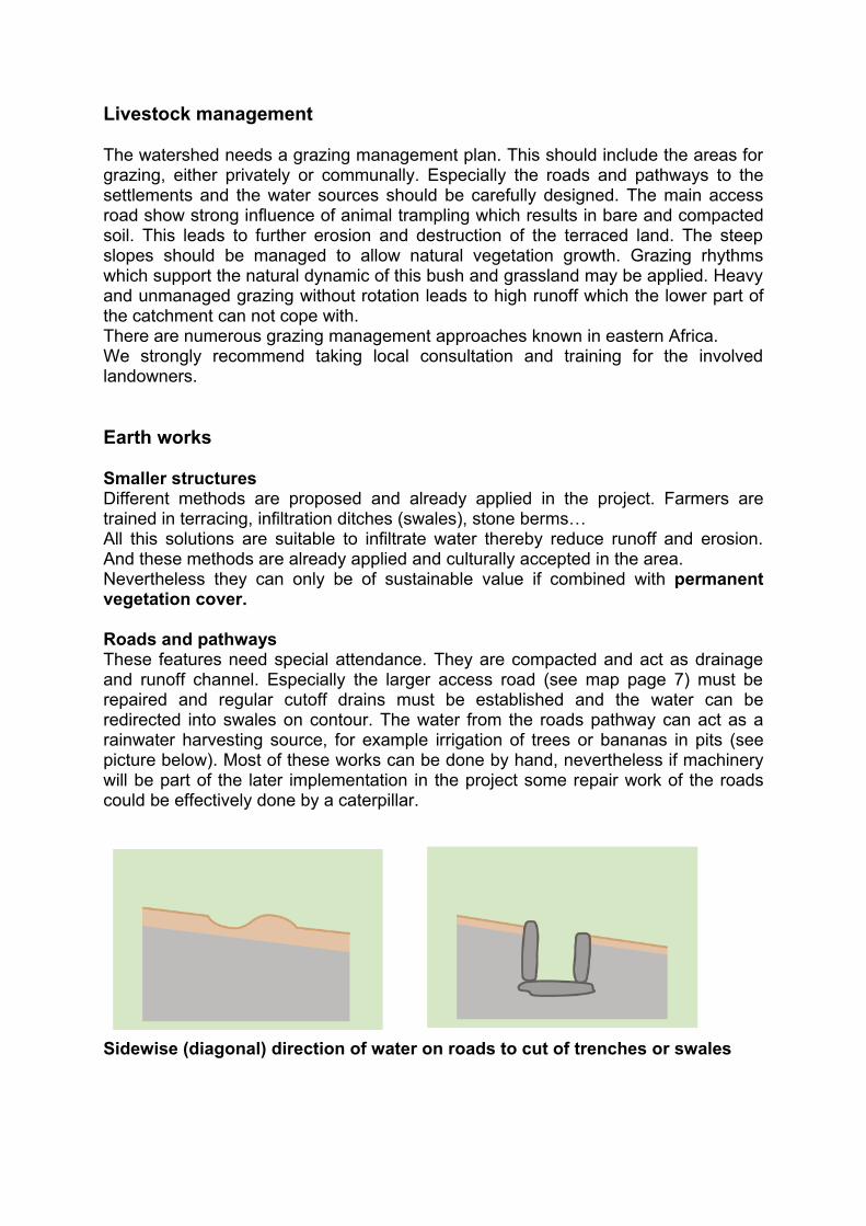
Roads and pathwaysThese features need special attendance. They are compacted and act as drainageand runoff channel. Especially the larger access road (see map page 7) must berepaired and regular cutoff drains must be established and the water can beredirected into swales on contour. The water from the roads pathway can act as arainwater harvesting source, for example irrigation of trees or bananas in pits (seepicture below). Most of these works can be done by hand, nevertheless if machinerywill be part of the later implementation in the project some repair work of the roadscould be effectively done by a caterpillar.
Sidewise (diagonal) direction of water on roads to cut of trenches or swales
Check damsFor the restoration of the gullies check dams are identified as the right measure. It isnecessary to start with small structures where the force of the water is small. Stones,or brush berms or living cuttings of trees/bushes, help to anchor the soil. Larger check dams can be built in the lower parts of the catchment and stop thecontinuous siltation of the dam reservoir. Nevertheless a serious of small structureswill help to stop the erosion where it starts and thereby help to infiltrate the water ona higher altitude. The smaller the amount of runoff which reaches the downhill part,the lower is the force of the water and the simpler the structures can be.For example: A check dam build in one of the main gullies close to the dam reservoir,must be build from concrete or gabions. Once the erosion is stoppedupstream/upslope also these structures can be built from stone, plant material orfrom earth.In some places the construction of check dams in the way a sand dam is build can beuseful.
Sand damsSand dams are constructed within the area to store water in a sand aquifer that formsbehind a concrete wall in a riverbed or gully. Hereby we can combine restoration andaccess to drinking water. Integrating concrete rings (or plastic pipes) before theprocess of siltation can allow access to water from a well kind of take off and inaddition monitor the status of the upper aquifer.
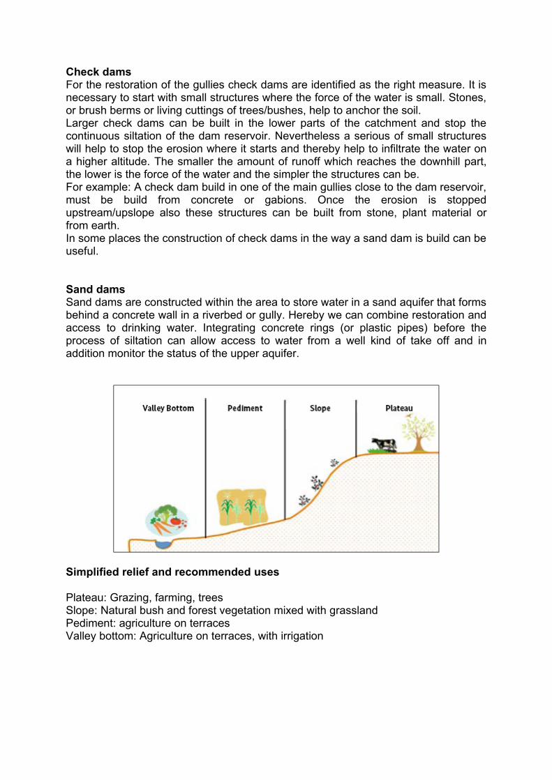
Simplified relief and recommended uses
Plateau: Grazing, farming, treesSlope: Natural bush and forest vegetation mixed with grasslandPediment: agriculture on terracesValley bottom: Agriculture on terraces, with irrigation

Recommendations
Before the start of the rain season
Spillway restorationThe spillway (overflow) of the Musosya earth dam needs urgent repair. As shown inthe picture (page 20) the dimension of the overflow is no longer adequate for theamount of the through flow. Therefore part of the dam is already eroded. If thiscontinues dam failure can occur. The overflow should be expanded (enlarged inwidth) on the outer side of the spillway (away from the earth dam). If runoff isreduced the spillway can be fully restored in future.
Exploration of upper aquiferDetermine the level of the upper aquifer by at least three sample diggings: close tothe dam, main valley upstream and in one of the larger site gullies. If possible applyconcrete rings or plastic pipes in the hand dug holes. This will allow monitoring thelevel of the upper aquifer 0-5 meters before the rain and from there on. Aquifer levelscan be measured with simple means as ropes or measuring tape. This will give thelocal community a connection to the water retained in their watershed aquifer.
Construction of a well in the silted damFor immediate water access a well can be easily constructed in the silted damreservoir, close to the dam wall on the opposite site of the spillway.
Installation of rain gaugeTo get precise rain fall data a rain gauge should be set up within the catchment.Besides the total amount of rainfall, especially the rainfall distribution and the maximaare of special interest for the future management.
Rainwater ManagementIn the current situation of the catchment the next rainfalls will cause more erosion.The full infiltration of the rainwater into the soil will start to recharge the aquifer.
Start on the top and work downhillIf the rainwater runoff of the plateau area is stopped, landowners of the lowercatchment only have to deal with the water that falls on their land. This willallow simplified restoration measures and avoid failure of these structures.
Start where the erosion beginsSmall mitigation measure at roads, pathways or on bare soil parts can changethe runoff drastically. On these spots working with a hoe, some brush materialand stones can make a huge difference.

Next steps
Precise mapping of area by land-use category and ownershipThe catchment border should be precisely identified and made public to alllandowners. The management team should get access to all available maps andaerial photographs. A topographic map has been purchased and given to the projectleaders. Working with Google earth can be sufficient; example maps are included inthis report. Involving a GIS expert may be considered. For working with thelandowners a simplified hand drawn map should be used . Especially in the uppernorth part of the watershed the borders could not be identified during the consultationfield visits. The whole plateau needs special attention for identifying the precisewatershed borders. This area is more or less flat, but rainwater uses paths and roadsto flow into the catchment.
The mapping should include:
Catchment border Borders of individual territories Main valleys Side valleys Roads, pathways Land-use Hot spots of erosion
Involvement of all landowners in the catchmentThe current land-use and future needs of each landowner must be assessed andmapped (number of animals, grazing area, area of agriculture land, access tofirewood…)The best practices of the area should be determined and shown to all landowners.The hot spots of erosion should be known by all watershed committee members andworked on in communal effort (e.g. roads, pathways)
Training on conservation farmingIn addition to the proposed training in terrace making of the landowners additionaltraining should be considered: Training in organic farming using existing regional examples, focus on cover
crops and mulching Experts on sustainable grazing techniques should be consulted
Cooperation with local experts Local expertise should be used for the implementation. Local NGO foster sand damsand well building. They also have long term experience in the formation of watershedmanagement committees.
Distribution of seeds and plant materialThe role of vegetation is essential for a full restoration of the catchment. Especiallyafter earthworks and on agriculture terraces immediate seeding and/or planting isrequired.The project outline includes setting up a tree nursery and supplying seed for a demofarm. We think that this subject should be expanded. Farmers should be trained inusing and collecting seeds and given a significant amount and variety of seeds to

start with. For the restoration of the gullies special local plants and tree cuttingsshould be used to anchor the embankments.
Monitoring of water patterns Wells and other water offtake situations can be used by the landowners and thewatershed committee to monitor the status of the upper aquifer. In addition therainfall data should be measured from now on, using a simple rain gauge. Runoff anderosion patterns and success of restoration methods should be monitored to have ameasurement for success and failure.
Decentralized access to drinking waterOne major goal of the project is to allow local and easy access to water for allcommunity members. To guarantee this we propose the following measures:Decentralized drinking water access through the installation of wells next to thevalleys and in the silted dam reservoirCombination of gully restoration by check-dams and sand-dams combined with wateroff takes (hand pump, well)
DeforestationOngoing cutting of trees, branches and bushes reduces the presence of trees andanchoring roots in the soil. In combination with unmanaged grazing this can lead tobare ground, with rock outcrops and absence of grasses. This bares a risk of moreerosion on steep slopes and even landslides.Therefore the steeper slopes should be vegetated with the natural bushlandvegetation. Probably in most areas a rest of cutting and grazing will allow naturalregeneration, as it can be observed on fenced or abandoned territories in the area(see picture). Nevertheless in some areas planting and seeding of natural vegetationis necessary. Sustainable grazing and firewood cutting can still be part of the futureland-use after restoration.For sustainable charcoal burning, brick making and domestic firewood agroforestryprinciples should be introduced.To stabilize the slopes of the terraces, berms and other earth structures rows of treescan be planted. These can be used for firewood and fodder for animals.Other sources for energy should be strongly considered especially the use of biogasdigester and the use of direct sun use (Scheffler mirror, photovoltaic and solarthermal collector)
Demonstrate best practices Identifying best practices which are already applied within the catchment area willallow to educate other landowners and to show the examples to the widercommunity.On the public land around the dam a model site could be chosen, to create ashowcase model at a place which has easy access. Demonstration of some of theapplied techniques in local schools will be of high educational value. This can becombined with the proposed WASH sessions and health education.
Use the watershed as a model for a full restoration and holistic managementWe recommend a prolongation of the project running time. Taking a 5 year period theproject will allow to fully restore the catchment and to show the results on aquiferrecharge, water availability for drinking and irrigation use.

Proposal for long term engagement, models and regenerative watermanagement
The proposal is to set up a model for a future settlement in one country where aidorganisations and their partners have a continuous engagement.This model should encompass all the successful components of the different worksof aid organisations and its partner organisation. It should be placed in a communitysetting in cooperation with local partners. The sustainable management of water, soiland energy form the material foundation of this model. The goal of the model is to showcase sustainable long-term solutions for settlements,both rural and urban and the livelihood of the inhabitants. The model is replicable andserves in addition as a training and education centre.Water is the basis of life and essential to all human settlement and livelihood. Thereare simple, yet sophisticated ways, in the design of settlements. Ecological designallows sustainable access to clean water and healthy food. The knowledge isavailable but rarely implemented. Every new settlement, be it preliminary orpermanent should recognize the aspect of water. Floods are avoided and thegroundwater is recharged by harvesting all rainwater. The aspect of water is bestregarded if all infrastructures are designed to serve the maximum for the restorationof water and soil. This includes houses, roads, paths, a master plan for the side thattakes recognition of the larger watershed and the areas downstream. Water forirrigation and livestock can be directly harvested and used from the rain. Drinkingwater can be obtained from wells or springs.All temporary camps can already include sustainable components, which will bereplicated in the reconstruction process. Some shelters in Haiti already includedrainwater harvesting and solar panels for electricity. If the camps are erectedincluding the knowledge of sustainable water management and restoration of soilsthey can in the first year deliver water and food to the people.Every catastrophe offers also opportunities, the opportunity for change. Most of thenatural catastrophes and the consequences to humans are man made. Floods arethe consequence of loss of vegetation and soil as a result of unsustainable land usepractises. It is possible to reverse the mistakes and restore the environments andnatural functions of ecosystems globally.
Large scale landscape restoration project in China documented by John D. Liuhttp://eempc.orgDecentralized settlements: “Tamera A Model for the Future” by Leila Dregger http://www.verlag-meiga.org/node/229

Education programs for sustainable and community based infrastructure and land use
Global Ecovillage Network (GEN)http://gen.ecovillage.org/http://www.gen-europe.org/
Ecovillage Design Education (EDE), UN endorsedhttp://www.gaiaeducation.net/
Permaculture Design Certificate (PDC)http://www.permaculture.org.uk/educationhttp://www.permacultureglobal.com/projects
Education and knowledge transfer on solar and water issueshttp://www.barefootcollege.org/
Landscape Restoration and regenerative water managementhttp://www.tamera.org/what-is-tamera/visitors3/events/water-landscape-training-2014/
Links
Rainwater HarvestingMetaMeta,www.bebuffered.comhttp://www.sasolfoundation.co.kewww.thewaterchannel.tvwww.samsamwater.com
Landscape Restoration Sustainable land-use in Ethiopiahttp://www.slmethiopia.info.et/
Water pumpingWater Pumpwww.kickstart.org
PermaculturePermaculture Research Institute Kenyahttp://www.pri-kenya.org/
FarmingThe organic farmer magazinehttp://www.theorganicfarmer.org/

Grazing ManagementAfrica Centre for Holistic Managementhttp://achmonline.squarespace.com/
Energy supply
SolarScheffler reflectors and other low tech solar technology (cookers, dryershttp://www.solare-bruecke.org/index.php?lang=enScheffler reflectors build by Alec Gagneux, solar export for community kitchens in Haitihttp://solarcooking.wikia.com/wiki/Alec_GagneuxSolar electrical systemshttp://self.org/
BiogasBiogas digester from Kenyahttp://www.biogas.co.ke/http://www.charitywater.org/
Biogas construction manualhttp://www.tamera.org/fileadmin/PDF/biogas_digester.pdfBiogas expert for urban areas and developing countries: T.H. Culhanehttp://solarcities.blogspot.pt/
Compost Toiletshttp://www.tamera.org/fileadmin/PDF/SV_CompostToilet.pdf

Photos
Bare ground as a result of grazing and animal trampling, compacted soil leadsto increased runoff and low infiltration
Erosion as a result of animal traffic towards lake

Spillway of Musosya earth dam, increased runoff starts to erode the dam, thishas to be immediately repaired to avoid a total dam failure
Grazing animals on silted Musosya dam reservoir, the growing vegetationshows the presence of water in the silted material

Hand dug swale for the avoidance of runoff and erosion, benefiting infiltration
Hand dug water hole 200 m upstream from Musosya dam, water in approx.1.5m depth

Bucket irrigated fields close to hand dug water hole
Gully development in two phases, sign of increase of runoff and eroding forcesSecondary gully eroding the terraced land

Gully in lowland 200 m from dam site
Soil profile in gully, layer of rock and gravel acts as a strong drainage to thesoil
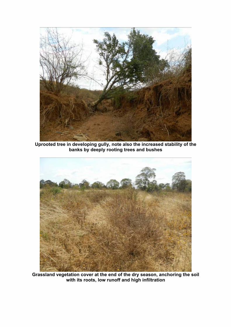
Uprooted tree in developing gully, note also the increased stability of thebanks by deeply rooting trees and bushes
Grassland vegetation cover at the end of the dry season, anchoring the soilwith its roots, low runoff and high infiltration

Grassland vegetation and litter (mulch) covering the soil, avoiding erosion andimmediate re-evaporation after rainfall, allowing infiltration, healthy grasslandcan absorb most (if not all) of the rainfall even in heavy rain events
Bare soil on terrace (left) and grassland vegetation (right) covering the soil,soil should always be covered with vegetation and litter (mulch), seed covercrops on terraces

Green vegetation at the end of the dry season, a sign that vegetation growth ispossible in the dry season, leguminous species covering the soil, anchoringsoil and fixing nitrogen, leads to humus accumulation, fodder for livestock
Vegetation grooving on slope of older bench terrace, slopes should always becovered with vegetation and well rooted with perennial vegetation, grassland,
bushes trees, the slopes can produce animal fodder or fruit trees

Newly established bench terrace (“Fanya juu terrace”), steep slopes will erodeimmediately with the first rainfall, seed and/or mulch to establish anchoring
vegetation
Nearly bare ground on harvested corn field, no anchoring roots left in soil, sothat the first rain will result into erosion. Seek for permanent vegetation cover,
animals can graze on the terraces but avoid uprooting of plants

Nearly bare ground on plateau ridge, soil is still anchored by the roots of treesand bushes but ground cover vegetation is missing so erosion continuously
occurs, managed grazing is necessary
Erosion and forming of gully on access road 100m downhill from plateau

Heavy erosion on steeper part of same road
Water finds an unmanaged path away from the road causing erosion ondownhill agricultural terraces

Animal traffic on road
Pits harvesting rainwater directly or by redirected road runoff for Banana,Papaya or other plants

Bananas growing in pits
Stone berms for controlling runoff, partly vegetated, stabilizing the slope andterrace foot
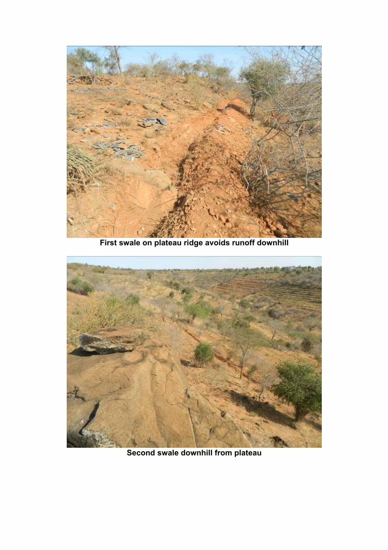
First swale on plateau ridge avoids runoff downhill
Second swale downhill from plateau