REPORT CARD 2016 - Department of Environment and … · water-bug score Buffalo Creek Shoal Bay B E...
16
DARWIN HARBOUR REGION REPORT CARD 2016 www.denr.nt.gov.au DEPARTMENT OF Environment and Natural Resources
Transcript of REPORT CARD 2016 - Department of Environment and … · water-bug score Buffalo Creek Shoal Bay B E...
DARWIN HARBOUR REGION REPORT CARD 2016
www.denr.nt.gov.au
DEPARTMENT OFEnvironment and Natural Resources
Message from the MinisterThe Territory’s natural environment is one of our greatest assets and it’s crucial that we continue to preserve and protect it for the benefit and enjoyment of future generations.
Our beautiful Darwin Harbour and its surrounds are home to a diverse range of flora, fauna and marine life and play an integral role in our unique outdoors lifestyle and our economy.
It’s pleasing that the 2016 Darwin Harbour Report Card confirms that the Harbour remains in great shape.
But we can’t afford to be complacent. We need to continue to carefully monitor and manage the way we interact with the Harbour to ensure its ongoing health, while ensuring that Territorians can continue to enjoy what it has to offer in terms of recreational activity and economic opportunities.
We are doing this by ensuring decisions about the management of the Harbour are based on science, and that new developments undergo a robust environmental assessment process.
This will allow us to better focus our protection efforts, while also generating jobs in research, innovative practice and emerging environment-based industries.
The community will also play a key role in decision-making through the reinstatement of the Darwin Harbour Advisory Committee which will include diverse representation.
The 2016 Darwin Harbour Report Card report provides an assessment of water quality across nine key regions and acknowledges that the Harbour’s water is in good condition but identifies a need for improvement in some areas.
Community input through the Darwin Harbour Advisory Committee will be critical in achieving these improvements. Its first task will be to develop a community-led, integrated, management plan to conserve the Harbour’s vital mangrove habitats.
The Department of Environment and Natural Resources will continue to monitor the health of the Harbour on an ongoing basis. Advice and input from the department as well as other scientific experts and from the community will ensure integrity and transparency in environmental decision-making and ensure the Harbour is preserved for the benefit of future generations.
The Hon. Lauren Moss MLA
Minister for Environment and Natural Resources
Integrated
monitoring and
management
are vital to
keeping check
on our harbour
and conserving
important
environmental
assets such as
mangroves.
DARWIN HARBOUR REGION REPORT CARD 20162

The Health of the Harbour
Darwin
Palmerston
Charles Point
Gunn Point
Outer Harbour
Middle Harbour
West Arm
Blackmore River
Elizabeth River
Myrmidon Creek
East Arm
Rapid Creek water-bug score
Buffalo Creek
Shoal Bay
B
E
A Excellent water quality. All four water quality indicators meet desired levels.
B Very good water quality. Three water quality indicators meet desired levels.
C Good water quality. Two water quality indicators meet desired levels.
D Poor water quality. Only one water quality indicator meets desired levels.
E Very poor water quality. No water quality indicators meet desired levels.
WATER QUALITY GRADES
No aquatic pests were found in Darwin Harbour for 2016
The beaches were suitable for swimming over the 2016 dry season
Overall the water quality of Darwin Harbour is in very good condition
A
A
A
B
A
A
B
B
3DARWIN HARBOUR REGION REPORT CARD 2016

Water clarity The plants in Darwin Harbour need light to photosynthesize and grow. Microscopic algae live in the water, whilst other plants, such as seagrasses, live on the mudflats and seabed. Stormwater and dredging can reduce water clarity and plant growth.
Dissolved oxygen
Oxygen dissolved in the water is essential for fish and other animals to survive. The amount of oxygen in the water can be reduced by water pollution.
Nutrients Nitrogen and phosphorus are nutrients required for algae to grow. However, high nutrient concentrations can increase the amount of algae, resulting in algal blooms which affect the broader environment.
Algae These are microscopic plants that may appear as specks in the water, or as a scum floating on the surface. Algae are an important part of the ecosystem in the harbour, but excessive amounts have a detrimental effect on the waterway.
The Report Card
Each region in the harbour was assessed for water quality from May 1, 2016 to October 30, 2016, and assigned a grade against four key water quality health indicators. These indicators are explained below.
DARWIN HARBOUR REGION REPORT CARD 20164

The Report Card grades were assessed against the Water Quality Objectives for Darwin Harbour.
Rapid Creek is the largest freshwater stream in the Darwin suburban area. The ecological health of Rapid Creek has been assessed using the AUSRIVAS assessment method since 2001. In 2016 sampling sites of Rapid Creek were given an AUSRIVAS score of B. This is consistent with previous years.
The eradication program for the aquatic weed Cabomba is continuing in Darwin River. It is important the weed is eradicated to ensure that it does not spread to Top End waterways. See the story on page 14 of this report for more detail.
Below is a table that shows water quality indicators for each region of the harbour, with a ✔ indicating those that met the desired level (known formally as a Water Quality Objective) and a ✖ indicating those that were unsatisfactory.
Harbour region
Indicator
Outer Harbour Inner Harbour Tidal creeks
Outer Darwin
Harbour
ShoalBay
MiddleDarwin
HarbourBlackmore East
Arm Elizabeth West Arm
Buffalo Creek
Myrmidon Creek
Water clarity ✔ ✔ ✔ ✔ ✔ ✔ ✔ ✖ ✔
Dissolved oxygen ✔ ✔ ✔ ✔ ✔ ✔ ✔ ✖ ✔
Algae ✔ ✔ ✔ ✔ ✔ ✔ ✔ ✖ ✔Nutrients ✖ ✖ ✔ ✔ ✔ ✔ ✔ ✖ ✖
Report Card grades
2016 B B A A A A A E B
2015 B A B B B B B E B
DARWIN HARBOUR REGION REPORT CARD 2016 5
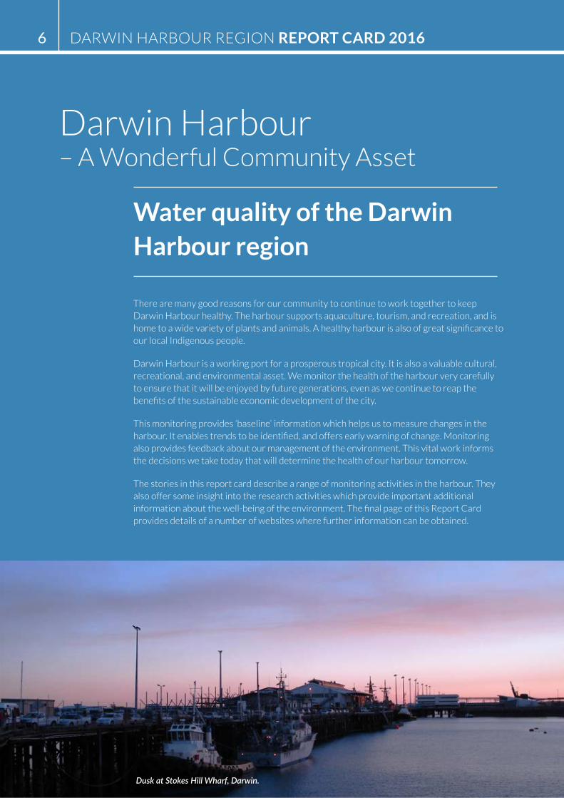
Darwin Harbour – A Wonderful Community Asset
Water quality of the Darwin Harbour region
There are many good reasons for our community to continue to work together to keep Darwin Harbour healthy. The harbour supports aquaculture, tourism, and recreation, and is home to a wide variety of plants and animals. A healthy harbour is also of great significance to our local Indigenous people.
Darwin Harbour is a working port for a prosperous tropical city. It is also a valuable cultural, recreational, and environmental asset. We monitor the health of the harbour very carefully to ensure that it will be enjoyed by future generations, even as we continue to reap the benefits of the sustainable economic development of the city.
This monitoring provides ‘baseline’ information which helps us to measure changes in the harbour. It enables trends to be identified, and offers early warning of change. Monitoring also provides feedback about our management of the environment. This vital work informs the decisions we take today that will determine the health of our harbour tomorrow.
The stories in this report card describe a range of monitoring activities in the harbour. They also offer some insight into the research activities which provide important additional information about the well-being of the environment. The final page of this Report Card provides details of a number of websites where further information can be obtained.
Dusk at Stokes Hill Wharf, Darwin.
DARWIN HARBOUR REGION REPORT CARD 20166
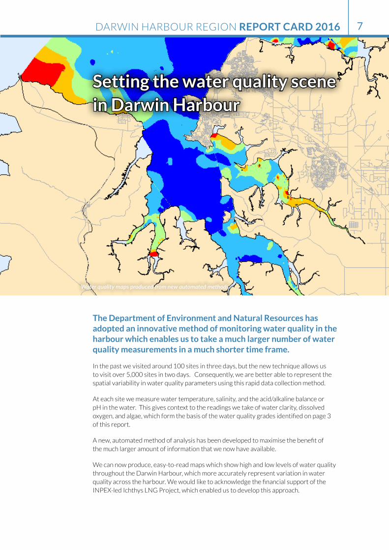
Setting the water quality scene in Darwin Harbour
The Department of Environment and Natural Resources has adopted an innovative method of monitoring water quality in the harbour which enables us to take a much larger number of water quality measurements in a much shorter time frame.
In the past we visited around 100 sites in three days, but the new technique allows us to visit over 5,000 sites in two days. Consequently, we are better able to represent the spatial variability in water quality parameters using this rapid data collection method.
At each site we measure water temperature, salinity, and the acid/alkaline balance or pH in the water. This gives context to the readings we take of water clarity, dissolved oxygen, and algae, which form the basis of the water quality grades identified on page 3 of this report.
A new, automated method of analysis has been developed to maximise the benefit of the much larger amount of information that we now have available.
We can now produce, easy-to-read maps which show high and low levels of water quality throughout the Darwin Harbour, which more accurately represent variation in water quality across the harbour. We would like to acknowledge the financial support of the INPEX-led Ichthys LNG Project, which enabled us to develop this approach.
Water quality maps produced from new automated methods
DARWIN HARBOUR REGION REPORT CARD 2016 7
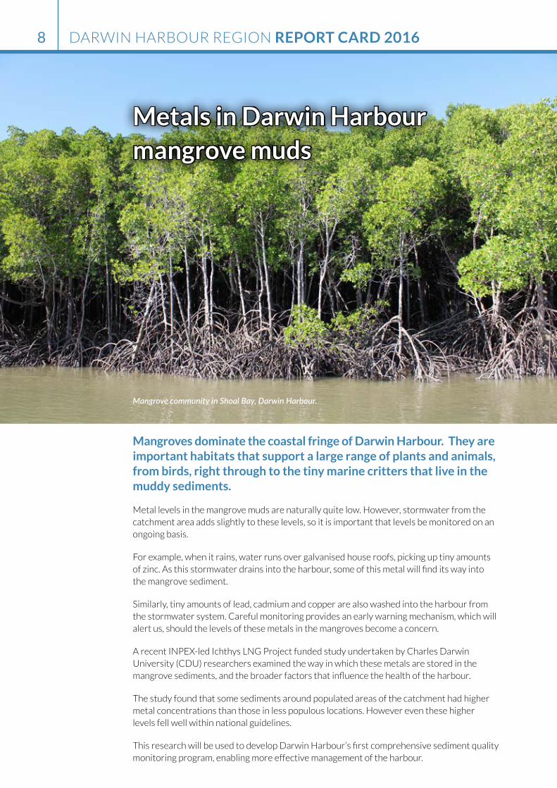
Metals in Darwin Harbour mangrove muds
Mangroves dominate the coastal fringe of Darwin Harbour. They are important habitats that support a large range of plants and animals, from birds, right through to the tiny marine critters that live in the muddy sediments.
Metal levels in the mangrove muds are naturally quite low. However, stormwater from the catchment area adds slightly to these levels, so it is important that levels be monitored on an ongoing basis.
For example, when it rains, water runs over galvanised house roofs, picking up tiny amounts of zinc. As this stormwater drains into the harbour, some of this metal will find its way into the mangrove sediment.
Similarly, tiny amounts of lead, cadmium and copper are also washed into the harbour from the stormwater system. Careful monitoring provides an early warning mechanism, which will alert us, should the levels of these metals in the mangroves become a concern.
A recent INPEX-led Ichthys LNG Project funded study undertaken by Charles Darwin University (CDU) researchers examined the way in which these metals are stored in the mangrove sediments, and the broader factors that influence the health of the harbour.
The study found that some sediments around populated areas of the catchment had higher metal concentrations than those in less populous locations. However even these higher levels fell well within national guidelines.
This research will be used to develop Darwin Harbour’s first comprehensive sediment quality monitoring program, enabling more effective management of the harbour.
Mangrove community in Shoal Bay, Darwin Harbour.
DARWIN HARBOUR REGION REPORT CARD 20168
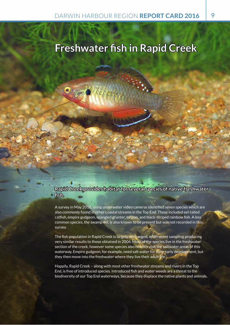
Freshwater fish in Rapid Creek
Rapid Creek provides habitat for several species of native freshwater fish.
A survey in May 2016, using underwater video cameras identified seven species which are also commonly found in other coastal streams in the Top End. These included eel-tailed catfish, empire gudgeon, spangled grunter, tarpon, and black-striped rainbow fish. A less common species, the swamp eel, is also known to be present but was not recorded in this survey.
The fish population in Rapid Creek is largely unchanged, with recent sampling producing very similar results to those obtained in 2006. Most of the species live in the freshwater section of the creek, however some species also need to visit the saltwater areas of this waterway. Empire gudgeon, for example, need salt water for their early development, but they then move into the freshwater where they live their adult life.
Happily, Rapid Creek – along with most other freshwater streams and rivers in the Top End, is free of introduced species. Introduced fish and water weeds are a threat to the biodiversity of our Top End waterways, because they displace the native plants and animals.
Empire gudgeon (Hypseleotris compressa).
DARWIN HARBOUR REGION REPORT CARD 2016 9
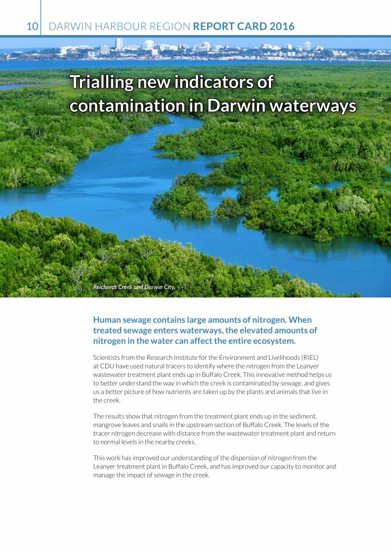
Trialling new indicators of contamination in Darwin waterways
Human sewage contains large amounts of nitrogen. When treated sewage enters waterways, the elevated amounts of nitrogen in the water can affect the entire ecosystem.
Scientists from the Research Institute for the Environment and Livelihoods (RIEL) at CDU have used natural tracers to identify where the nitrogen from the Leanyer wastewater treatment plant ends up in Buffalo Creek. This innovative method helps us to better understand the way in which the creek is contaminated by sewage, and gives us a better picture of how nutrients are taken up by the plants and animals that live in the creek.
The results show that nitrogen from the treatment plant ends up in the sediment, mangrove leaves and snails in the upstream section of Buffalo Creek. The levels of the tracer nitrogen decrease with distance from the wastewater treatment plant and return to normal levels in the nearby creeks.
This work has improved our understanding of the dispersion of nitrogen from the Leanyer treatment plant in Buffalo Creek, and has improved our capacity to monitor and manage the impact of sewage in the creek.
Reichardt Creek and Darwin City.
DARWIN HARBOUR REGION REPORT CARD 201610

The ‘long-way around’ – migratory shorebirds of Darwin Harbour
Darwin Harbour is home to 25 of the 37 species of migratory shorebirds that visit Australia, including sandpipers and whimbrels.
These birds spend their time feeding on bugs in the intertidal mud during low tide, and then move to higher ground when the tide comes in. Many sites around Darwin are considered significant because of the number of species they support, and the sheer abundance of these long distance travellers.
Each year, migratory shorebirds come to Australia for the southern summer. These birds arrive in coastal areas, grasslands, and freshwater wetlands after flying thousands of kilometres from their breeding grounds. This epic southward migration begins in Siberia, Alaska and Mongolia and these birds face multiple threats on their journey, as their habitat at various places along the way is threatened by development.
Protecting our coastal environment is vital for the ongoing health of these birds. They need roosting space near feeding grounds, and healthy habitat that is undisturbed. The many people and dogs that visit popular local beaches tend to scare the birds away. Consequently, other locations need to be made available for the birds.
Great Knots taking flight at Sandy Creek beach.
DARWIN HARBOUR REGION REPORT CARD 2016 11
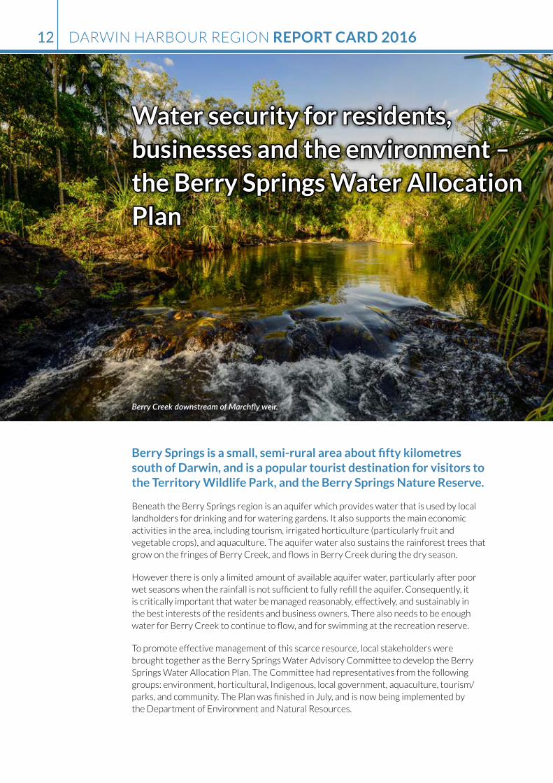
Water security for residents, businesses and the environment – the Berry Springs Water Allocation Plan
Berry Springs is a small, semi-rural area about fifty kilometres south of Darwin, and is a popular tourist destination for visitors to the Territory Wildlife Park, and the Berry Springs Nature Reserve.
Beneath the Berry Springs region is an aquifer which provides water that is used by local landholders for drinking and for watering gardens. It also supports the main economic activities in the area, including tourism, irrigated horticulture (particularly fruit and vegetable crops), and aquaculture. The aquifer water also sustains the rainforest trees that grow on the fringes of Berry Creek, and flows in Berry Creek during the dry season.
However there is only a limited amount of available aquifer water, particularly after poor wet seasons when the rainfall is not sufficient to fully refill the aquifer. Consequently, it is critically important that water be managed reasonably, effectively, and sustainably in the best interests of the residents and business owners. There also needs to be enough water for Berry Creek to continue to flow, and for swimming at the recreation reserve.
To promote effective management of this scarce resource, local stakeholders were brought together as the Berry Springs Water Advisory Committee to develop the Berry Springs Water Allocation Plan. The Committee had representatives from the following groups: environment, horticultural, Indigenous, local government, aquaculture, tourism/parks, and community. The Plan was finished in July, and is now being implemented by the Department of Environment and Natural Resources.
Berry Creek downstream of Marchfly weir.
DARWIN HARBOUR REGION REPORT CARD 201612
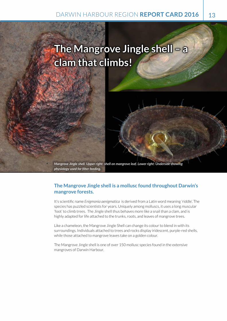
The Mangrove Jingle shell – a clam that climbs!
The Mangrove Jingle shell is a mollusc found throughout Darwin’s mangrove forests.
It’s scientific name Enigmonia aenigmatica is derived from a Latin word meaning ‘riddle’. The species has puzzled scientists for years. Uniquely among molluscs, it uses a long muscular ‘foot’ to climb trees. The Jingle shell thus behaves more like a snail than a clam, and is highly adapted for life attached to the trunks, roots, and leaves of mangrove trees.
Like a chameleon, the Mangrove Jingle Shell can change its colour to blend in with its surroundings. Individuals attached to trees and rocks display iridescent, purple-red shells, while those attached to mangrove leaves take on a golden colour.
The Mangrove Jingle shell is one of over 150 mollusc species found in the extensive mangroves of Darwin Harbour.
Mangrove Jingle shell. Upper right: shell on mangrove leaf. Lower right: Underside showing physiology used for filter feeding.
DARWIN HARBOUR REGION REPORT CARD 2016 13

Don’t release your aquarium plants into the environment
Many Darwin homes feature a fish tank or decorative pond that is filled with exotic plants.
Aquarium plants may grow very quickly in an aquarium, and will also grow very quickly at the local lake, river or creek, often taking over from native species. Releasing these plants into the natural environment can have widespread ecological implications. They are almost impossible to eradicate, and can be very costly to keep under control.
Cabomba, for example, is a highly invasive aquatic weed which was released into the Darwin River around 2003-2004, causing a massive infestation in the river. An expensive 12 year dedicated eradication program has not yet eliminated this dangerous weed.
Some of the worst aquatic weeds in our region are sagittaria, cabomba, water hyacinth, and parrot’s feather. It is against the law to buy, sell, or transport these weeds. For more information please call the Weed Management Branch of the Department of Environment and Natural Resources on 8999 4567 or visit www.nt.gov.au/weeds
Should you see any of these weeds shown below for sale, or growing in local areas, please notify the Weed Management Branch immediately.
Department of Environment and Natural Resources Weeds staff spray Cabomba on a section of Darwin River.
DARWIN HARBOUR REGION REPORT CARD 201614

Further information:
Previous Report Cards:
https://denr.nt.gov.au/land-resource-management/water-resources/darwin-harbour/darwin-harbour-region-report-cards
Darwin Harbour Region Report Card water quality:
Darwin Harbour Region 2016 Report Card - Water Quality Supplement. Department of Environment and Natural Resources https://denr.nt.gov.au/land-resource-management/water-resources/darwin-harbour/darwin-harbour-region-report-cards
Aquatic pest monitoring:
http://www.nt.gov.au/d/Fisheries/index.cfm?header=Aquatic%20Biosecurity
Dolphin monitoring:
https://nt.gov.au/environment/environment-data-maps/darwin-harbour-biodiversity-monitoring
Beach monitoring:
https://nt.gov.au/emergency/community-safety/darwin-beaches-water-quality
Ichthys LNG Project nearshore environmental monitoring:
http://www.ichthysproject.com/environment
Weeds information:
http://nt.gov.au/environment/weeds
Wildwatch:
Watch out for our wildlife. A hotline to help manage and respond to marine wildlife incidents in our seas and rivers.
http://nt.gov.au/environment/environment-data-maps/marine-coastal-biodiversity
Northern Territory Seafood Council:
http://www.ntsc.com.au/darwin-harbour-clean-up-2016
We gratefully acknowledge the contribution from the following people for stories in the 2016 edition of the Darwin
Harbour Region Report Card: Ruth Patterson, Dr Niels Munksgaard, Dr Peter Dostine, Kanchana Niwanthi
Warnakulasooriya, Amanda Lilleyman, Liza Schenkel, Dr Kristin Metcalfe, Adam Bourke, Belinda Townend and
Geraldine Lee.
DARWIN HARBOUR REGION REPORT CARD 2016 15
www.denr.nt.gov.au