Report and recommendations of the Environmental Protection ... 1505 Hinge IO... · KML proposes to...
37
Report and recommendations of the Environmental Protection Authority Report 1505 March 2014 Karara Mining Ltd (Joint venture between Ansteel and Gindalbie Metals Limited) Hinge Iron Ore Project
-
Upload
truongtruc -
Category
Documents
-
view
215 -
download
0
Transcript of Report and recommendations of the Environmental Protection ... 1505 Hinge IO... · KML proposes to...

Report and recommendations of the Environmental Protection Authority
Report 1505
March 2014
Karara Mining Ltd
(Joint venture between Ansteel and Gindalbie Metals Limited)
Hinge Iron Ore Project

ii
Assessment on Proponent Information Environmental Impact Assessment Process Timelines
Date Progress stages Time (weeks)
2/12/13 Level of assessment set
19/02/14 Final information required for assessment received from Proponent
11
19/03/14 Provision of EPA Report to the Minister 4
24/03/14 Publication of EPA report (3 working days after report to the Minister)
3 days
7/04/14 Close of appeals period 2
Timelines for an assessment may vary according to the complexity of the project and are usually agreed with the proponent soon after the level of assessment is determined. In this case, the Environmental Protection Authority met its timeline objective for the completion of the assessment and provision of a recommendation to the Minister.
Dr Paul Vogel Chairman 19 March 2014 ISSN 1836-0483 (Print) ISSN 1836-0491 (Online) Assessment No. 1992

i
Contents Page
1. Introduction and background ..................................................................1
2. The proposal ...........................................................................................2
3. Consultation ............................................................................................5
4. Key environmental factors ......................................................................5 4.1 Flora and Vegetation ....................................................................6 4.2 Subterranean Fauna ....................................................................8 4.3 Offsets (Integrating Factor) ..........................................................9
5. Recommended conditions .................................................................... 10
6. Other advice ......................................................................................... 10
7. Conclusions .......................................................................................... 11
8. Recommendations ................................................................................ 12
Figures Figure 1: Regional locality map ...........................................................................3 Figure 2: Hinge development envelope and haul road layout .............................4 Appendices 1. References 2. Identified Decision-making Authorities and Recommended
Environmental Conditions 3. Preliminary key factors not requiring further assessment and
management under Part IV 4. Proponent’s Environmental Referral Document and further information

ii

1
1. Introduction and background This report provides the Environmental Protection Authority’s (EPA’s) advice and recommendations to the Minister for Environment on the proposal by Karara Mining Ltd (KML) to develop and operate an open pit iron ore mine and associated infrastructure approximately 76 kilometres (km) north-east of Perenjori town site in the Midwest region of Western Australia. Section 44 of the Environmental Protection Act 1986 (EP Act) requires the EPA to report to the Minister for Environment on the outcome of its assessment of a proposal. The report must set out:
• the key environmental factors identified in the course of the assessment; and
• the EPA’s recommendations as to whether or not the proposal may be implemented, and, if the EPA recommends that implementation be allowed, the conditions and procedures to which implementation should be subject.
The EPA may include in the report any other advice and recommendations as it sees fit. The proponent submitted an Environmental Referral (ER) document setting out the details of the proposal, potential environmental impacts and proposed commitments to manage those impacts. Based on the information and investigations undertaken in the ER document, the EPA decided that it did not need to issue a scoping guideline for the preparation of an API environmental review document. The EPA’s assessment was therefore primarily based on the referral document and further information provided by the proponent to clarify certain aspects of the proposal and its management. The referral information and further information is included as Appendix 4 (Karara Mining Limited, 2013). The EPA considers that the proposal, as described, can be managed to meet the EPA’s environmental objectives, subject to the EPA’s recommended conditions being made legally binding. This report provides the EPA advice and recommendations in accordance with section 44 of the EP Act.
2
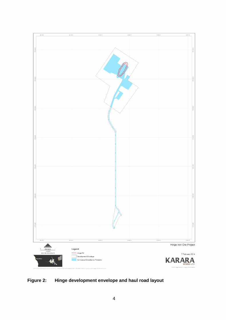
2. The proposal KML proposes to develop the Hinge Iron Ore Proposal (HIOP) approximately 76 km north-east of Perenjori town site in the Midwest region of Western Australia (Figure 1). The HIOP proposed development includes:
• a single open cut pit; • associated infrastructure (maintenance workshops, hardstand areas,
refuelling facilities, washdown bays, administration buildings, magazine, turkey’s nest, storage areas);
• haul road and access road connecting new pits and infrastructure to existing mining areas on the Blue Hills Range;
• production of 1-2 million tonnes of haematite ore per year; • expected project life of two years, possibly extending to four years
depending on mining rate; and • direct vegetation clearing of 300 hectares (ha) inside a 680 ha development
envelope for the mine, and 30 ha inside a 120 ha development envelope for the haul road.
The proposal area is located approximately 10 km north of the Terapod deposit which, together with the Blue Hills North deposit and associated infrastructure, forms the previously approved Mungada Iron Ore Proposal (MIOP) proposal. KML proposes to link the HIOP minesite with the Terapod mining area via a haul road and utilise the crushing and screening plant located at the Blue Hills North mining area. KML has also indicated an option for a crushing and screening plant and a run-of-mine pad, to be located at the HIOP site. If this was to occur the clearing would be within the development envelope (680 ha) and within the direct vegetation clearing area (300 ha). The crushing and screening plant is unlikely to raise significant environmental factors and the potential impacts of the plant would be regulated and managed under Part V of the EP Act to meet the EPA’s objectives. The mining tenements on which the minesite and haul road would be located underlie the ex-Karara pastoral lease currently managed by the Department of Parks and Wildlife (DPaW) for the purposes of conservation. The potential impacts of the proposal are discussed by the proponent in the ER document (see Appendix 4).

3
Figure 1: Regional locality map
4
Figure 2: Hinge development envelope and haul road layout

5
3. Consultation During the preparation of the ER document, the proponent has undertaken consultation with government agencies and key stakeholders. The agencies, groups and organisations consulted are detailed in the ER document (Karara Mining Limited, 2013). Table 3-2 in the ER document summarises the consultations to date, and the planned consultations, for the HIOP. The EPA considers that the consultation process has been appropriate and that reasonable steps have been taken to inform the community and stakeholders of the proposed development.
4. Key environmental factors It is the EPA’s opinion that the following key environmental factors relevant to the proposal require evaluation in this report:
(a) Flora and vegetation; (b) Subterranean fauna; and (c) Offsets (integrating factor).
In assessing the proposal, the EPA notes that the proponent has sought to avoid, minimise and rectify environmental impacts associated with the proposal by:
• siting mining-related activities and the proposed haul road to minimise potential impact to conservation significant flora, vegetation and fauna;
• ensuring that current KML flora and vegetation management plans for the Karara region are put into practice at the HIOP. These plans identify measures to minimise potential impacts to flora and vegetation, prevent the spread of existing weeds and minimise the risk of introducing weeds;
• ensuring that current KML fauna management plans are put into practice at the HIOP. These plans identify measures to minimise potential impacts to conservation significant fauna and managing feral animals; and
• rehabilitating in an ecological sustainable manner, consistent with agreed outcomes and land uses, and without unacceptable liability to the State.

6
4.1 Flora and Vegetation The EPA’s environmental objective for this factor is to maintain representation, diversity, viability and ecological function at the species, population and community level. The proposal has the potential to impact flora and vegetation predominantly from clearing. The proposal would require total clearing of up to 330 ha of native vegetation within the 800 ha mine and haul road proposal development envelope. The proposal’s development envelope, conceptual disturbance footprint and the haul road layout are presented in Figure 2. The Blue Hills Range is considered to be one of the Yilgarn Banded Ironstone Formation (BIF) Ranges with the highest biodiversity values. This is reflected in the 2007 Strategic Review of the Conservation and Resource Values of Banded Iron Formation of the Yilgarn Craton (BIF Strategic Review). The Strategic Review is an important reference document in relation to the environmental values of the BIF ranges. The HIOP sits just north of the Blue Hills Range, located in the Central Tallering area. The BIF Strategic Review identifies this area as of lower biodiversity, although still providing refugial habitats with localised species and vegetation communities. The proposal is not located on areas identified as having significant landscape features. A number of vegetation and flora surveys have been previously conducted in relation to the existing approved Greater Karara Project which includes the Karara Iron Ore Proposal (KIOP) and the MIOP. In addition, the DPaW has conducted floristic assessments in the broader region, one of which included the survey area (Markey and Dillon 2008a; Markey and Dillon 2008b). As an offset for the KIOP proposal, KML committed to conducting mapping of floristic communities in the region. Woodman Environmental Consulting Pty Ltd (Woodman Environmental) has undertaken a regional vegetation survey (Woodman, 2012) on behalf of KML to meet this commitment. Woodman Environmental also undertook the 2008 regional mapping for the KIOP and MIOP proposals. KML also commissioned Astron Environmental Services (2013) and Outback Ecology Services (2013) to undertake Level 2 flora and vegetation surveys of the minesite and haul road respectively. The EPA sought advice from the DPaW regarding the updated Woodman (2012) regional mapping and the specific flora and vegetation surveys for the HIOP. The DPaW advised the EPA that it was not possible to provide specific comment on the Woodman (2012) regional mapping at this time as it had not been provided to the Department to enable a formal review and analysis of the mapping and associated floristic data. Notwithstanding the above, the DPaW advised that the nature of the HIOP is such that it expects that the impacts are able to be assessed and are potentially manageable via the EPA’s formal review process. Following this advice, KML provided the full regional mapping report and related floristic data to the DPaW.
7
The DPaW are currently undertaking a review and analysis of the 2012 regional mapping. The local flora and vegetation surveys of the minesite and haul road development envelopes did not locate any Declared Rare Flora or Threatened Flora pursuant to State and Commonwealth legislation. In total, eight species of Priority flora were recorded within the development envelopes. All priority species have been recorded at other locations outside the minesite and haul road area. No Threatened Ecological Communities (TEC) pursuant to Commonwealth legislation or listed by the DPaW were recorded within the disturbance footprint. Woodman (2012) identified particular Floristic Community Types (FCTs) considered to be of conservation significance as they have the potential to represent the Midwest 2: Blue Hills (Mount Karara/Mungada Ridge/Blue Hills) vegetation complexes (banded ironstone formation) PEC (Blue Hills PEC), listed as Priority 1. Of the FCTs potentially representing the Blue Hills PEC, approximately 188 ha would be impacted by the HIOP. Consistent with the findings of the BIF Strategic Review these areas represent localised and in some cases isolated areas of these important vegetation communities. The EPA notes that KML has also stated that it has sited mining-related activities and the proposed haul road to minimise potential impact to conservation significant flora and vegetation. KML has the following active operational management plans for the Greater Karara Project which identify measures to minimise potential impacts to flora and vegetation, prevent the spread of existing weeds and minimise the risk of introducing weeds:
• KML’s Construction and Operational Environmental Management Plans (CORP-EN-PLN-1001 and CORP-EN-PLN-1020 respectively);
• Environmental Procedure – Approvals Requests and Ground Disturbance (CORP-EN-PRO-1004); and
• Environmental Procedure – Flora, Weeds and Plant Pathogens (CORP-EN-PRO-1009).
The EPA considers that these management plans should be updated, in consultation with the land managers, the DPaW, to include the HIOP. To ensure the proposal is implemented consistent with that proposed by the proponent the location and authorised extent of clearing is recommended to be limited to a total no more than 300 ha within a 680 ha development envelope for the mine and clearing of no more than 30 ha within a development envelope of 120 ha for the haul road. The authorised extent of clearing of the conservation significant FCTs identified in Woodmans (2012) report is limited to the 188 ha proposed by the proponent. The location and authorised extent of clearing is described and spatially defined in the recommended statement that the proposal can be implemented

8
(Appendix 2). No further conditions to manage Flora and Vegetation are recommended as being necessary. Summary Having particular regard to:
• no Declared Rare Fora, Threatened flora species or TECs being recorded in the surveyed areas for the mine and haul road;
• the minimal percentage impacts by the proposal to the potential PECs on a regional basis; and
• the measures that the proponent has committed to take to avoid, minimise and rectify impacts to flora and vegetation,
the EPA considers that the proposal can be managed to meet the EPA’s objective for Flora and Vegetation provided that the location and authorised extent of the physical and operational elements of the proposal are limited to that defined in Schedules 1 and 3 of the recommended statement that the proposal can be implemented (Appendix 2). 4.2 Subterranean Fauna The EPA’s environmental objective for this factor is to maintain representation, diversity, viability and ecological function at the species, population and assemblage level. Mining and dewatering will remove and reduce the extent of potential stygofauna habitat, and remove and alter the humidity levels of potential troglofauna habitat. The EPA’s EAG 12 Consideration of subterranean fauna in environmental impact assessment in WA (June, 2013) identifies that the BIF have a high likelihood of habitat supporting subterranean fauna especially where groundwater and voids are present and hydrated zones where there is a lot of jointing and fracturing. KML commissioned Rockwater Proprietary Limited (2014a) to undertake a desktop assessment for the likelihood of subterranean fauna being present at the HIOP area (Appendix 4). The desktop assessment was completed in accordance with the EPA’s EAG 12 and concluded that potential troglofauna habitat may exist in the zones of iron-enrichment at the HIOP area. The BIF unit at the HIOP area does not represent a unique habitat in a regional context, but there is potential for troglofauna, if found, to be restricted at a small-scale (Rockwater, 2014a). Based on the desktop findings KML submitted a proposal for Subterranean Fauna sampling for the HIOP area to the EPA in February 2014 (Appendix 4). The EPA recommends that a condition requiring the proponent to implement the sampling program prior to ground disturbing activities be imposed (see recommended condition 6, Appendix 2). The condition provides for the proponent to identify the risk to the long-term viability of subterranean species and provides for management actions to be implemented to mitigate the risk; along with the contingency actions.

9
Recommended condition 7 provides for the proponent to offset potential significant residual risks to the long-term viability of subterranean fauna species, if required. Summary Having particular regard to the desktop assessment undertaken by the proponent identifying that:
• based on previous regional studies in the area the likelihood of finding stygofauna within the disturbance area is low and sampling is not recommended, and
• potential troglofauna habitat may exist in the zones of iron-enrichment at Hinge and that troglofauna may be restricted at a small-scale,
the EPA considers that the proposal can be managed to meet the EPA’s objective for subterranean fauna provided that:
• recommended condition 6 which requires the proponent to undertake sampling to identify the risk to the long-term viability of subterranean species and provides for management actions and contingency measures to be implemented to mitigate the risk; and
• recommended condition 7 which requires the proponent to offset potential significant residual risks to the long-term viability of subterranean fauna species,
are imposed on the proposal. 4.3 Offsets (Integrating Factor) The EPA’s environmental objective for this factor is to counterbalance any significant residual environmental impacts or uncertainty through the application of offsets. At this stage, a contingency offset has been recommended by the EPA to address the uncertainty and risk to the long-term viability of subterranean fauna species. The potential risk to regionally significant subterranean fauna is that, if found, they may be highly localised. The offset will only be triggered if the sampling program (condition 6) identifies the presence of subterranean fauna and if monitoring of these, in accordance with the Subterranean Fauna Management Plan, indicates that project operations may compromise the long-term viability of a population of regionally significant subterranean fauna species. The EPA recommends that the proponent must undertake a Subterranean Fauna Research Project that relates to the results of the survey and has the objective of increasing knowledge and understanding of subterranean fauna in the Midwest region. The specific project must focus on the species identified from the sampling program and must be developed in consultation with the DPaW and the Western Australian Museum. The value of the offset should also be dependent on the extent of species that may be compromised and the costs required to undertake detailed research activities, possibly including regional surveys and genetic testing.

10
Consistent with the approach outlined above, the EPA has recommended condition 7 (Appendix 2) to address the potential for a significant residual impact on subterranean fauna. 5. Recommended conditions Having considered the information provided in this report, the EPA has developed a set of conditions that the EPA recommends be imposed if the proposal by KML to develop and operate an open pit iron ore mine and associated infrastructure is approved for implementation. These conditions are presented in Appendix 2.
6. Other advice Regional mapping The EPA recommends that KML consult with the DPaW regarding Woodman’s (2012) regional mapping and Woodman’s redefinition of the potential Blue Hills PEC boundaries. The EPA considers that DPaW endorsement of the updated regional mapping is important, particularly for any future proposals that may be referred in the recognised high biodiversity area of the Blue Hills Range. Verified regional survey data will be essential for understanding the biodiversity values of the area, the significance of potential environmental impacts and the cumulative impacts. Mine closure and rehabilitation KML commissioned Soil Water Consultants (2013) to undertake a geochemical characterisation to assess the potential for acid rock drainage and metaliferous drainage to occur following disturbance. Although there appears to be negligible risk of acid mine drainage and it is predicted that the pit lake will form a groundwater sink, the EPA considers that there may be potential for adverse geochemical changes to the water quality of the pit lake from non-acid (metalliferous) mine drainage post-closure. The EPA also considers that there may be potential for downstream impacts of any leakage from the pit. KML has advised that the Mine Closure Plan will be developed in accordance with EPA/Department of Mines and Petroleum (DMP) (2011) Joint Guidelines on Preparing Mine Closure Plans and submitted to the DMP. The DMP will undertake a detailed assessment once the plan is submitted. In considering the development of the Mine Closure Plan the EPA notes that pit lake water quality will be impacted by the quality of the inflowing groundwater, evaporation rate, geochemistry of the soils that make up the walls and basement of the pit lake, quality of any surface inflow, and the depth and strength of stratification in the lake. Predicting pit lake water quality at equilibrium conditions is not a trivial matter and it is not possible to predict with certainty what the quality of the pit lake water will be in 100, 1,000 or 10,000 years. The Mine Closure Plan needs to ensure that sufficient temporal monitoring of the pit lake water quality takes place to validate the modelling

11
predictions. Particular attention needs to be paid to the concentration of heavy metals in the water if the salinity is such that it might be frequented by birds and/or other biota. The EPA objective for the pit lake is that the quality of groundwater and surface water must be maintained so that the environmental values, both ecological and social, are protected. If impacts to biota are predicted on the basis of the monitoring results then the Mine Closure Plan must require the proponent to undertake action to mitigate the impacts. Possible options could be to fill in the pit to above the watertable or treatment of the water in the lake. Another potential impact of a pit lake is density-driven outflow that could impact on the quality of the surrounding groundwater. The proponent has predicted that there will be no outflow from the pit lake based on water balance modelling, however this does not take into account density-driven outflow which could occur if the density of the bottom water in the pit lake is significantly higher than the surrounding groundwater. If a risk assessment of worst-case saline outflow shows that there is potential for impact to the environment from groundwater discharges to a surface water body and/or groundwater dependent vegetation, the Mine Closure Plan needs to ensure that monitoring of groundwater quality at depths, consistent with the total depth of the pit lake, is conducted. The monitoring plan needs to consider that, if the basement of the aquifer slopes away from the pit in the opposite direction to the general groundwater flow, density-driven plumes can migrate against the general groundwater flow direction and monitoring wells should be located accordingly. In fractured media, density-driven outflow could occur at many depths so monitoring wells should be fully screened to allow capture of the dense water and sampling conducted at discreet depths based on the conductivity profile in the well. Modelling of density-driven outflow plume length needs to consider that the pit lake will be a source of dense water in perpetuity in most cases and impact zones could be considerable over time. The proposal is also located on land that will be managed by the DPaW in the long-term, following cessation of mining. The EPA expects that the DMP will consult with the DPaW and seek endorsement of the Mine Closure Plan. The Mine Closure Plan should be prepared in accordance with the EPA/DMP Joint Guidelines on Preparing Mine Closure Plans or subsequent revisions, should have the objective to not leave the State with an unacceptable liability, and should include completion criteria that are developed in consultation with the DPaW.
7. Conclusions The EPA has considered the proposal by KML to develop and operate an open pit iron ore mine, associated infrastructure and haul road. The EPA notes that the proponent has actively sought to avoid, minimise and rectify environmental impacts through the design of the proposal. The flora and vegetation surveys of the minesite and haul road development envelopes did not locate any Declared Rare Flora, Threatened Flora or TECs. The location and authorised extent of clearing is described and spatially defined in the
12
recommended statement that the proposal can be implemented. No additional conditions are recommended to manage potential impacts on flora and vegetation. In relation to Subterranean Fauna, the desktop assessment identifies that, based on previous regional studies in the area, the likelihood of finding stygofauna within the disturbance area is low. However, potential troglofauna habitat has been identified and, if found, troglofauna may be restricted at a small scale. The EPA has recommended condition 6 which provides for the proponent to undertake further sampling to identify the risk to the long-term viability of subterranean fauna species and provides for management actions and contingency measures to be implemented to mitigate the risk. The EPA has considered the proponent’s application and demonstration of avoiding and minimising environmental impacts, and recommended relevant conditions to ensure this occurs. The EPA considers that there is potential for the proposal to have a significant residual impact in relation to the environmental factor of Subterranean Fauna if the sampling program (condition 6) identifies that the project operations may compromise the long-term viability of a population of regionally significant subterranean fauna species. The EPA has concluded that the proposal can be managed to meet the EPA’s environmental objectives, provided the proposal is implemented consistent with the conditions and authorised extent of the proposal in the recommended Ministerial Statement (Appendix 2).
8. Recommendations The EPA submits the following recommendations to the Minister for Environment. That the Minister:
1. notes that the proposal being assessed is for Karara Mining Ltd to develop and operate an open pit iron ore mine, associated infrastructure and haul road;
2. considers the report on the key environmental factors as set out in Section 4;
3. notes the proponent’s application of avoidance and minimisation principles identified in this report;
4. notes that the EPA has concluded that the proposal can be managed to meet the EPA’s environmental objectives, provided there is satisfactory implementation by the proponent of the recommended conditions set out in Appendix 2;
5. imposes the conditions and procedures recommended in Appendix 2 of this report; and
6. notes the EPA’s other advice presented in Section 6 in relation to regional mapping and mine closure and rehabilitation.

Appendix 1
References

Astron Environmental Services (2013). Hinge Iron Ore Study Vegetation and Flora Survey. Unpublished report for Karara Mining Ltd, May 2013. Environmental Protection Authority (2004). EPA Guidance Statement 51: Terrestrial Flora and Vegetation Surveys for Environmental Impact Assessment in Western Australia, Environmental Protection Authority, Perth, June 2004. Environmental Protection Authority (2013). EPA Assessment Guideline 12: Consideration of subterranean fauna in environmental impact assessment in Western Australia, Environmental Protection Authority, Perth, June 2013. Government of Western Australia (2007). Strategic Review of the Conservation and Resource Values of Banded Iron Formation of the Yilgarn Craton. Government of Western Australia (2011). Guidelines for Preparing Mine Closure Plans. Markey, A. S. & Dillon, S. J. (2008a). Flora and Vegetation of the Banded Ironstone Formations of the Yilgarn Craton: The Central Tallering Land System. In: Conservation Science W. Aust. 7 (1), pp 121–149. Markey, A. S. & Dillon, S. J. (2008b in prep). Flora and Vegetation of the Banded Iron Formations of the Yilgarn Craton: Yalgoo. Department of Environment and Conservation. Available: http://naturemap.dec.wa.gov.au/default.aspx. Outback Ecology Services (2013). Targeted Flora and Vegetation Assessment – Hinge Haul Road. Unpublished report for Karara Mining Ltd, April 2013. Rockwater (2013). Hinge Iron Ore Deposit Results of Permeability Testing. Unpublished report for Gindalbie Metals Ltd, February 2013. Rockwater Proprietary Limited (2014a). Hinge Iron Ore Deposit Subterranean Fauna Desktop Assessment. Unpublished report for Gindalbie Metals Ltd, February 2014. Rockwater Proprietary Limited (2014b). Proposal for Subterranean Fauna Sampling for the Hinge Deposit. Unpublished report for Gindalbie Metals Ltd, February 2014. Soil Water Consultants (2013). Hinge Deposit Geochemical Characterisation. June 2013. Woodman Environmental (2008). Karara-Mungada Project Survey Area. Flora and Vegetation. Unpublished report for Gindalbie Metals Ltd, May 2008. Woodman Environmental Consulting (2012). Regional Flora and Vegetation Survey of the Karara to Minjar Block. Unpublished report for Karara Mining Ltd, April 2012.

Appendix 2
Identified Decision-making Authorities and
Recommended Environmental Conditions

Identified Decision-making Authorities
Section 44(2) of the Environmental Protection Act 1986 (EP Act) specifies that the EPA’s report must set out (if it recommends that implementation be allowed) the conditions and procedures, if any, to which implementation should be subject. This Appendix contains the EPA’s recommended conditions and procedures. Section 45(1) requires the Minister for Environment to consult with decision-making authorities, and if possible, agree on whether or not the proposal may be implemented, and if so, to what conditions and procedures, if any, that implementation should be subject. The following decision-making authorities have been identified for this consultation:
Decision making authority Approval
1. Minister for Water Rights in Water and Irrigation Act 1914 Water extraction licence
2. Minister for Aboriginal Affairs
Aboriginal Heritage Act 1972 s18 approval
3. Minister for Environment Wildlife Conservation Act 1950 Taking of protected flora and fauna
4. Director General, Department of Environment Regulation
Environmental Protection Act 1986 Works approval and licence
5. Director General, Department of Mines and Petroleum
Dangerous Goods Dangerous Goods Safety Act 2004; Storage and handling of hazardous materials Chief Dangerous Goods Officer Mine Safety Mines Safety and Inspection Act 1994 District Inspector, Resources Safety Branch
6. Director Environment Division, Department of Mines and Petroleum
Mining Act 1978 Approval of mining proposal
Note: In this instance, agreement is only required with DMAs 1 - 3 since these DMAs are Ministers.

Statement No. XXX
RECOMMENDED ENVIRONMENTAL CONDITIONS
STATEMENT THAT A PROPOSAL MAY BE IMPLEMENTED (PURSUANT TO THE PROVISIONS OF THE ENVIRONMENTAL PROTECTION ACT 1986)
HINGE IRON ORE PROJECT
Proposal: To develop and operate an iron ore mine, supporting infrastructure and a haul road, 76 km north-east of Geraldton in the Midwest region, as documented in Schedule 1 of this statement.
Proponent: KARARA MINING LTD Australian Company Number 68070871831
Proponent Address: Level 8 London House, 216 St Georges Tce
PERTH WA 6000
Assessment Number: 1992
Report of the Environmental Protection Authority Number: 1505
This Statement authorises the implementation of the Proposal described and documented in Columns 1 and 2 of Table 2 of Schedule 1. The implementation of the Proposal is subject to the following implementation conditions and procedures and Schedule 2 details definitions of terms and phrases used in the implementation conditions and procedures. 1 Proposal Implementation 1-1 When implementing the proposal, the proponent shall not exceed the
authorised extent of the proposal as defined in Column 3 of Table 2 in Schedule 1, unless amendments to the proposal and the authorised extent of the Proposal has been approved under the EP Act.
2 Contact Details 2-1 The proponent shall notify the CEO of any change of its name, physical
address or postal address for the serving of notices or other correspondence within twenty eight (28) days of such change. Where the proponent is a corporation or an association of persons, whether incorporated or not, the postal address is that of the principal place of business or of the principal office in the State.

3 Time Limit for Proposal Implementation 3-1 The proponent shall not commence implementation of the proposal after the
expiration of five (5) years from the date of this statement, and any commencement, within this five (5) year period, must be substantial.
3-2 Any commencement of implementation of the proposal, within five (5) years from the date of this statement, must be demonstrated as substantial by providing the CEO with written evidence, on or before the expiration of five (5) years from the date of this statement.
4 Compliance Reporting 4-1 The proponent shall prepare and maintain a compliance assessment plan to
the satisfaction of the CEO. 4-2 The proponent shall submit to the CEO the compliance assessment plan
required by condition 4-1 at least six (6) months prior to the first compliance assessment report required by condition 4-6, or prior to implementation, whichever is sooner. The compliance assessment plan shall indicate: (1) the frequency of compliance reporting; (2) the approach and timing of compliance assessments; (3) the retention of compliance assessments; (4) the method of reporting of potential non-compliances and corrective
actions taken; (5) the table of contents of compliance assessment reports; and (6) public availability of compliance assessment reports.
4-3 The proponent shall assess compliance with conditions in accordance with the compliance assessment plan required by condition 4-1.
4-4 The proponent shall retain reports of all compliance assessments described in the compliance assessment plan required by condition 4-1 and shall make those reports available when requested by the CEO.
4-5 The proponent shall advise the CEO of any potential non-compliance within seven days of that non-compliance being known.
4-6 The proponent shall submit to the CEO the first compliance assessment report 15 months from the date of issue of this Statement addressing the twelve (12) month period from the date of issue of this Statement and then annually from the date of submission of the first compliance assessment report. The compliance assessment report shall: (1) be endorsed by the proponent’s Chief Executive Officer or a person
delegated to sign on the Chief Executive Officer’s behalf; (2) include a statement as to whether the proponent has complied with the
conditions; (3) identify all potential non-compliances and describe corrective and
preventative actions taken;

(4) be made publicly available in accordance with the approved compliance assessment plan; and
(5) indicate any proposed changes to the compliance assessment plan required by condition 4-1.
5 Public Availability of Data 5-1 Subject to condition 5-2, within a reasonable time period approved by the CEO
of the issue of this statement and for the remainder of the life of the proposal the proponent shall make publicly available, in a manner approved by the CEO, all validated environmental data (including sampling design, sampling methodologies, empirical data and derived information products (e.g. maps)) relevant to the assessment of this proposal and implementation of this Statement.
5-2 If any data referred to in condition 5-1 contains particulars of: (1) a secret formula or process; or (2) confidential commercially sensitive information; the proponent may submit a request for approval from the CEO to not make this data publically available. In making such a request the proponent shall provide the CEO with an explanation and reasons why the data should not be made publically available.
6 Subterranean fauna
6-1 Prior to the commencement of ground disturbing activities, the proponent shall implement the Gindalbie Metals Limited Subterranean Fauna Sampling Proposal for the Hinge Deposit provided to the Office of the EPA (19 February 2014) and report its findings to the CEO.
6-2 If the CEO determines that the sampling required under 6-1 has identified subterranean fauna that is regionally significant within the proposal envelope as defined in schedule 1 of this Statement, the proponent is to prepare a Subterranean Fauna Management Plan, prior to ground disturbing activities, to the requirements of the CEO. If the CEO determines that sampling undertaken in accordance with 6-1 does not identify subterranean fauna that is regionally significant within the proposal envelope as defined in schedule 1 of this statement, then the conditions 6-2 to 6-9 and 7 are not required to be implemented.
6-3 The objective of the Subterranean Fauna Management Plan is to ensure that
mine construction and operational activities are carried out in a manner that minimise the impacts to the subterranean fauna.
6-4 The Subterranean Fauna Management Plan required by condition 6-2 shall set out procedures and measures to: (1) when implemented, substantiate whether condition 6-3 is being met;

(2) include a description of procedures for recording the distribution of species of subterranean fauna and relevant aspects of subterranean fauna habitat to ensure that the long-term viability of subterranean fauna species is not at risk as a result of implementation of the proposal; and
(3) identify management and/or contingency measures to be implemented in the event that the impacts to the long-term viability of subterranean fauna species and their habitats may be unknown or at risk as a result of implementing the proposal.
6-5 The proponent shall implement the approved Subterranean Fauna
Management Plan required by condition 6-2 until the CEO advises implementation may cease.
6-6 In the event that monitoring required by condition 6-4(2) indicates that implementation of the proposal may pose a risk to the long-term viability of subterranean fauna species the proponent shall: (1) provide a report to the CEO within twenty eight (28) days of
identification that implementation of the proposal may pose a risk to the long-term viability of subterranean species, proposing measures to avoid, mitigate or offset these risks.
6-7 The proponent may review and revise the Subterranean Fauna Management
Plan to the requirements of the CEO. 6-8 The proponent shall review and revise the Subterranean Fauna Management
Plan as and when directed by the CEO. 6-9 The proponent shall implement the approved revisions of the Subterranean
Fauna Management Plan required by conditions 6-7 and 6-8. 7 Offsets 7-1 If pursuant to condition 6-6(1), the CEO determines that risks to the long-term
viability of subterranean fauna species may be offset, the proponent shall prepare a Subterranean Fauna Research Project and submit it to the CEO for approval.
7-2 The Subterranean Fauna Research Project pursuant to condition 7-1 shall:
(1) detail the funding arrangement that has been agreed to by the CEO;
(2) when implemented, meet the objective of increasing knowledge and understanding of subterranean fauna in the Midwest region; and
(3) be prepared in consultation with the Department of Parks and Wildlife
and the Western Australian Museum.

7-3 The proponent shall implement the approved Subterranean Fauna Research Project within twelve (12) months of results from surveys pursuant to condition 6-2.
7-4 The proponent shall implement the approved Subterranean Fauna Research
Project until the CEO advises implementation may cease. 7-5 A report shall be submitted to the CEO documenting the results of the
Subterranean Fauna Research Project, identifying the findings of the research required by condition 7-2.

Schedule 1 Table 1: Summary of the Proposal Proposal Title Hinge Iron Ore Project Short Description The proposal is to develop and operate an iron ore mine,
supporting infrastructure and a haul road, 76 km north-east of Perenjori in the Midwest region.
Table 2: Location and authorised extent of physical and operational elements
Column 1 Column 2 Column 3 Element Location Authorised Extent
Mine pits and infrastructure area
Figure 2 and geographic coordinates of the Project Development Envelope in Schedule 2.
Clearing no more than 300 ha of vegetation within the 680 ha mine Development Envelope. Clearing of up to a combined total of 188 ha of the areas identified in Woodman’s (2012) report as ‘FCTs 1,2,3,4,5,6,10 and 12’ within the Development Envelope.
Haul road Figure 2 and geographic coordinates of the Project Haul Road in Schedule 2.
Clearing no more than 30 ha vegetation within a 120 ha haul road Development Envelope.

Schedule 2 Table 3: Abbreviations Abbreviation Term CEO The Chief Executive Officer of the Department of the Public Service
of the State responsible for the administration of section 48 of the Environmental Protection Act 1986, or his delegate.
EPA Environmental Protection Authority EP Act Environmental Protection Act 1986 ha hectare km kilometre FCT Floristic Community Type
Figures (attached) Figure 1: Regional locality map Figure 2: Hinge development envelope and haul road layout

Figure 1 Regional locality map

Figure 2: Hinge development envelope and haul road layout

Schedule 3
HINGE IRON ORE PROJECT Coordinates that define the Development Envelope and Haul Road end points
Hinge Mine Site Development Envelope Easting (MGA94 z50) Northing (MGA94 z50)
487015.42 6790160.53 488611.30 6789118.58 487881.01 6787933.25 488607.75 6787430.52 487349.93 6785654.21 486253.80 6786428.14 486659.58 6787515.62 485672.75 6788213.59
Hinge Haul Rd End Points Easting (MGA94 z50) Northing (MGA94 z50)
486939.58 6777728.88 486683.92 6786124.36 486769.41 6786063.98 487461.56 6778698.11

Notes The following notes are provided for information and do not form a part of the implementation conditions of the Statement:
• The proponent for the time being nominated by the Minister for Environment under section 38(6) of the EP Act is responsible for the implementation of the proposal unless and until that nomination has been revoked and another person is nominated.
• If the person nominated by the Minister, ceases to have responsibility for the proposal, that person is required to provide written notice to the Environmental Protection Authority of its intention to relinquish responsibility for the proposal and the name of the person to whom responsibility for the proposal will pass or has passed. The Minister for Environment may revoke a nomination made under section 38(6) of the EP Act and nominate another person.
• To initiate a change of proponent, the nominated proponent and proposed proponent are required to complete and submit Post Assessment Form 1 – Application to Change Nominated Proponent.
• The General Manager of the Office of the Environmental Protection Authority was the Chief Executive Officer of the Department of the Public Service of the State responsible for the administration of section 48 of the EP Act at the time the Statement was signed by the Minister for Environment.


Appendix 3
Preliminary key factor not requiring further evaluation in the EPA report
The EPA identified the following key environmental factors in the scope of the API which, at the conclusion of the assessment, was not considered to be a key environmental factor warranting discussion and evaluation in the EPA’s assessment report.

Factor and EPA objective
Activities and potential impacts Relevant legislation and policy
Assessment, management and mitigation of impacts
Terrestrial Fauna To maintain representation, diversity, viability and ecological function at the species, population and assemblage level
Shield-backed trapdoor spider (SBTS) (Schedule 1 WC Act; Vulnerable EPBC Act 1999) Based on predicted distribution, the spider population size at HIOP is estimated at approximately 19,500 spiders (1,904 within the proposed pit). Total disturbance from the HIOP proposal on local spider population is approximately 10%. Compared to KIOP, MIOP and SIOP, HIOP has a lower density of spiders. Potential cumulative impact on SBTS population for KML surveyed proposal areas only (KIOP, MIOP, SIOP and HIOP) is 9.5%. Malleefowl (Schedule 1 WC Act; Vulnerable EPBC Act 1999) One active mound and two sets of footprints recorded in surveys but outside impact area. 28 inactive mounds in the development envelope.
Wildlife Conservation Act 1950 (WC Act)
Regional surveys have identified that the SBTS is widely distributed through the Karara region. KML will place associated works in areas adjacent to the Hinge ridge and away from Eucalypt Woodland with large trees and logs and the hill to the east of the site (SBTS and Western Spiny-tailed Skink potential habitat). Impact to Malleefowl anticipated to be minor because, while the species is known to be sensitive to roadkill, there is extensive suitable habitat on the plains around Hinge away from mining and vehicle activity. KML will minimise chance of roadkill through speed limits (especially in areas of high wildlife activity such as close to Malleefowl mounds, water sources and at watercourse crossings). Install signage in areas where species such as Malleefowl are regularly seen. In the event an active Malleefowl mound is detected and unable to be avoided, a Regulation 15 licence under the WC Act will be sought with the DPaW. Management Plans for Karara region: • Fauna Management Plan. • Feral Animal Management
Plan. • Environmental Procedure –
Terrestrial Fauna Management.
• Environmental Procedure – Shield-Backed Trapdoor Spider Management and Monitoring.
• Environmental Procedure – Western Spiny Tailed Skink Management, Monitoring and Translocation.

Factor and EPA objective
Activities and potential impacts Relevant legislation and policy
Assessment, management and mitigation of impacts
Hydrological Processes To maintain the hydrological regime of groundwater and surface water so that existing and potential uses, including ecosystem maintenance are protected.
The proposal will require approximately 60 000 kL/a of water in the first year and 350 000 kL/a in subsequent years. Water for mining is proposed to be sourced from abstraction bores located within or adjacent to the mining operations, or from supplies from existing licences at Terapod and Blue Hills North. Should this option be required, water will be transferred via pipelines and/or water carts along the Hinge Haul Road. Rockwater (2013) recorded the static water level within the Hinge proposal area at approximately 330 mAHD, equating to 50-65 mbg. This suggests that mine pit dewatering will be required to maintain mining below water table.
Rights in Water and Irrigation Act 1914 (RIWI Act)
The water required for mining operations can be regulated and managed by the Department of Water (DoW) under the provisions of the RIWI Act and in accordance with DoW’s water in mining guidelines. Prior to the commencement of any groundwater abstraction, a Licence to Take Water under 5C of the RIWI Act is required. The 5C licence will be accompanied with a Borefield Operating Strategy (including safe yields, water level trigger values and monitoring procedures) developed in accordance with the DoW.
Offsets – integrating factor To counterbalance any significant residual environmental impacts or uncertainty through the application of offsets
The proposal would result in the clearing and disturbance of up to 330 ha of vegetation. This clearing and disturbance has potential impacts on Flora and Vegetation, and Terrestrial Fauna including Subterranean Fauna.
There are no Declared Rare Flora nor Threatened Ecological Communities in the proposal area, and the scale of the proposal and the area to be impacted would not warrant offsets. Malleefowl and the Shield-backed trapdoor spider populations will not be significantly impacted. There are not likely to be significant residual impacts on these species. In view of the above, offsets are not required for Flora and Vegetation and Terrestrial Fauna. The EPA has recommended condition 7 potentially requiring the proponent to offset significant residual impacts to subterranean fauna.
Rehabilitation and closure – integrating factor To ensure that premises are closed, decommissioned and rehabilitated in an ecologically sustainable
Potential impacts of the proposal at closure include: • failure to establish a safe non-
polluting landform; • failure to establish self-sustaining
vegetative cover; and • contamination and altered
Mining Act 1978 DMP/EPA Guidelines for Preparing Mine Closure
The proponent is required under the Mining Act 1978 to submit a Mining Proposal and a Mine Closure Plan. Rehabilitation and Closure can be regulated and Managed by the DMP in accordance with

Factor and EPA objective
Activities and potential impacts Relevant legislation and policy
Assessment, management and mitigation of impacts
manner, consistent with agreed outcomes and land uses, and without unacceptable liability to the State
groundwater and surface water regimes.
Plans (2011) DMP/EPA joint guidelines, Guidelines on Preparing Mine Closure Plans.

Appendix 4
Provided on CD
Attachment 1 - Hinge Iron Ore Proposal Environmental Referral Document and
Appendices. Attachment 2 - Woodman Environmental Consulting (2012). Regional Flora and
Vegetation Survey of the Karara to Minjar Block. Unpublished report for Karara Mining Ltd, April 2012.
Attachment 3 - Karara Mining Limited Environmental Management Plans. Attachment 4 - Rockwater Proprietary Limited (2014a). Hinge Iron Ore Deposit
Subterranean Fauna Desktop Assessment. Unpublished report for Gindalbie Metals Ltd, February 2014.
Attachment 5 - Rockwater Proprietary Limited (2014b). Proposal for Subterranean
Fauna Sampling for the Hinge Deposit. Unpublished report for Gindalbie Metals Ltd, February 2014.