Relationship between electrical resistivity and basic ...
12
Relationship between electrical resistivity and basic geotechnical parameters for marine clays Long, M., Donohue, S., L’Heureux, J-S., Solberg, I-L., Rønning, J. S., Limacher, R., O'Connor, P., Sauvin, G., Romoen, M., & Lecomte, I. (2012). Relationship between electrical resistivity and basic geotechnical parameters for marine clays. Canadian Geotechnical Journal, 49(10), 1158-1168. https://doi.org/10.1139/T2012-080 Published in: Canadian Geotechnical Journal Document Version: Peer reviewed version Queen's University Belfast - Research Portal: Link to publication record in Queen's University Belfast Research Portal General rights Copyright for the publications made accessible via the Queen's University Belfast Research Portal is retained by the author(s) and / or other copyright owners and it is a condition of accessing these publications that users recognise and abide by the legal requirements associated with these rights. Take down policy The Research Portal is Queen's institutional repository that provides access to Queen's research output. Every effort has been made to ensure that content in the Research Portal does not infringe any person's rights, or applicable UK laws. If you discover content in the Research Portal that you believe breaches copyright or violates any law, please contact [email protected]. Download date:03. Apr. 2022
Transcript of Relationship between electrical resistivity and basic ...

Relationship between electrical resistivity and basic geotechnicalparameters for marine clays
Long, M., Donohue, S., L’Heureux, J-S., Solberg, I-L., Rønning, J. S., Limacher, R., O'Connor, P., Sauvin, G.,Romoen, M., & Lecomte, I. (2012). Relationship between electrical resistivity and basic geotechnical parametersfor marine clays. Canadian Geotechnical Journal, 49(10), 1158-1168. https://doi.org/10.1139/T2012-080
Published in:Canadian Geotechnical Journal
Document Version:Peer reviewed version
Queen's University Belfast - Research Portal:Link to publication record in Queen's University Belfast Research Portal
General rightsCopyright for the publications made accessible via the Queen's University Belfast Research Portal is retained by the author(s) and / or othercopyright owners and it is a condition of accessing these publications that users recognise and abide by the legal requirements associatedwith these rights.
Take down policyThe Research Portal is Queen's institutional repository that provides access to Queen's research output. Every effort has been made toensure that content in the Research Portal does not infringe any person's rights, or applicable UK laws. If you discover content in theResearch Portal that you believe breaches copyright or violates any law, please contact [email protected].
Download date:03. Apr. 2022

Relationship between electrical resistivity andbasic geotechnical parameters for marine clays
Michael Long, Shane Donohue, Jean-Sebastien L’Heureux, Inger-Lise Solberg,Jan Steinar Rønning, Romaric Limacher, Peter O’Connor, Guillaume Sauvin,Magnus Rømoen, and Isabelle Lecomte
Abstract: Recently, considerable efforts have been made in the attempt to map quick clay areas using electrical resistivitymeasurements. However there is a lack of understanding regarding which soil parameters control the measured resistivityvalues. To address this issue, inverted resistivity values from 15 marine clay sites in Norway have been compared with basicgeotechnical index properties. It was found that the resistivity value is strongly controlled by the salt content of the porefluid. Resistivity decreases rapidly with increasing salt content. There is also a relatively clear trend of decreasing resistivitywith increasing clay content and plasticity index. Resistivity values become very low (≈5 U·m) for high clay content(>50%), medium- to high-plasticity (Ip≈ 20%) materials with salt content values greater than about 8 g/L (or correspondingremoulded shear strength values greater than 4 kPa). For the range of values studied, there is poor correlation between resis-tivity and bulk density and between resistivity and water content. The data studied suggest that the range of resistivity val-ues corresponding to quick clay is 10 to 100 U·m, which is consistent with other published limits. A comparison is madebetween two-dimensional electrical resistivity tomography (ERT) and resistivity cone penetration test (RCPTU) data for twoof the sites and the two sets of data show similar trends and values irrespective of scale effect.
Key words: marine clay, quick clay, geophysics, resistivity, laboratory testing, Norway.
Résumé : Récemment, des efforts considérables ont été déployés dans le but de cartographier les zones d’argile sensible àl’aide de mesures de résistivité électrique. Cependant, on ne comprend pas encore bien quels paramètres des sols contrôlentles mesures de résistivité obtenues. Pour remédier à cette situation, des valeurs de résistivité obtenues sur 15 sites d’argilemarine en Norvège ont été comparées aux propriétés géotechniques de base. Il a été déterminé que la valeur de la résistivitéest fortement contrôlée par le contenu en sel du fluide interstitiel. La résistivité diminue rapidement lorsque le contenu ensel augmente. On observe aussi une tendance claire à la diminution de la résistivité lorsque le contenu en argile et l’indicede plasticité augmentent. Les valeurs de résistivité deviennent très faibles (≈ 5 U·m) pour des teneurs en argile élevées(>50%), pour des matériaux ayant une plasticité moyenne à élevée (Ip ≈ 20%) avec des valeurs de contenu en sel supérieu-res à environ 8 g/L (ou des valeurs de résistance au cisaillement remoulée correspondantes supérieures à 4 kPa). Pour lagamme de valeurs étudiées, la corrélation entre la résistivité et la masse volumique apparente, et entre la résistivité et la te-neur en eau, est faible. Les données étudiées suggèrent que la gamme de valeurs de résistivités correspondant à l’argile sen-sible est de 10 à 100 U·m, ce qui concorde avec d’autres limites publiées. Une comparaison est présentée entre les donnéesde tomographie en résistivité électrique (ERT) à deux dimensions et l’essai de résistivité de pénétration au cône (RCPTU)pour deux sites, et les deux séries de données démontrent des tendances similaires et des valeurs ne tenant pas compte del’effet d’échelle.
Mots‐clés : argile marine, argile sensible, géophysique, résistivité, essais en laboratoire, Norvège.
[Traduit par la Rédaction]
Received 2 February 2012. Accepted 2 August 2012. Published at www.nrcresearchpress.com/cgj on .
M. Long and R. Limacher. Department of Civil, Structural and Environmental Engineering, University College Dublin (UCD), NewsteadBuilding, Belfield, Dublin 4, Ireland.S. Donohue. University of Bath, Bath, UK; formerly University College Dublin (UCD), Dublin, Ireland.J.-S. L’Heureux. Geological Survey of Norway (NGU), Trondheim, Norway; International Centre for Geohazards (ICG) at NGI, Oslo,Norway.I.-L. Solberg. Geological Survey of Norway (NGU), Trondheim, Norway.J.S. Rønning. Geological Survey of Norway (NGU), Trondheim, Norway; Norwegian University of Science and Technology (NTNU),Trondheim, Norway.P. O’Connor. APEX Geoservices, Gorey, Co. Wexford, Ireland.G. Sauvin. International Centre for Geohazards (ICG) at NGI, Oslo, Norway; NORSAR, Kjeller, Norway; University of Oslo (UiO), Oslo,Norway.M. Rømoen. Norwegian Geotechnical Institute (NGI), Oslo, Norway.I. Lecomte. International Centre for Geohazards (ICG) at NGI, Oslo, Norway; NORSAR, Kjeller, Norway.
Corresponding author: Mike Long (e-mail: [email protected]).
Pagination not final/Pagination non finale
1
Can. Geotech. J. 49: 1–11 (2012) doi:10.1139/T2012-080 Published by NRC Research Press
PROOF/ÉPREUVE
lbeznaczuk
Sticky Note
Figure placement will be adjusted at the next layout stage. Our house style is to place a figure after (and as close as possible to) its first citation in the text.

IntroductionIn recent years considerable efforts have been made in
Norway and Sweden with respect to mapping of quick clayformations using combined geotechnical and geophysicalmethods. Although it was recognised that some intrusivegeotechnical investigations will always be necessary, the ob-jective of these studies was to develop techniques to maxi-mize the use of nonintrusive relatively simple geophysicalsurveys such as electrical resistivity tomography (ERT). Forexample Solberg et al. (2008, 2012) and Lecomte et al.(2008a) describe the use of resistivity measurements for map-ping quick clay at landslide areas at Buvika, mid Norway;Rødde, mid Norway; and Finneidfjord, northern Norway; re-spectively. Donohue et al. (2011) and Pfaffhuber et al. (2010)detail integrated geophysical work with similar objectives fora site at Smørgrav in Southern Norway and Sauvin et al.(2011) outline comparable work at an adjacent site at Vålen.Similar work in Sweden has been published by Dahlin et al.(2005), Lundström et al. (2009), and Löfroth et al. (2011).Parallel work has been carried out on use of the resistivity
cone penetration test (RCPTU) in quick clay areas in bothNorway (e.g., Rømoen et al. 2010) and in Sweden (Dahlinet al. 2004; Schälin and Tornborg 2009; Löfroth et al. 2011).Although most recent research efforts on this topic have
taken place in Scandinavia, quick clays continue to pose ahazard in other countries such as Canada (Geertsema andTorrance 2005) and Japan (Torrance and Ohtsubo 1995).Perhaps not surprisingly these studies found that there is
no simple correlation between resistivity and sensitivity, asthey can be influenced by factors such as the density, watercontent, silt fraction, fabric and structures of the soil, chemis-try of the pore fluid, and mineralogy of the clay particles.The objective of the present work is to investigate the in-
fluence of the basic index parameters of Norwegian clays onthe measured resistivity values to obtain a deeper understand-ing of what controls the values. The ultimate intention is toprovide assistance to practicing engineers in the interpretationof resistivity surveys in marine clay areas.In this study, clay properties from geotechnical testing are
compared with resistivity data, mainly from ERT, at 15 sites.At three of the sites (Rissa, Finneidfjord, and Kattmarka),large destructive quick clay landslides had occurred; see Gre-gersen (1981) and L’Heureux et al. (2011a), Longva et al.(2003) and L’Heureux et al. (2011b), and Nordal et al.(2009) and Solberg et al. (2011), respectively.
The sitesThe location of the sites is shown in Fig. 1. The sites are
all located in coastal areas of Norway coinciding with thoselocations underlain by elevated marine clays. The sites maybe grouped as follows:
• Southern Norway: E16Kjørby – Wøyen, Skøyen – Asker,RVII – Hilleren, Drammen – Museumpark, Farriseidet,Skienselven, Månejordet, Smørgrav, and Vålen.
• Mid Norway: Berg, Rissa, Rødde, and Buvika.• North Trøndelag and Northern Norway: Finneidfjord and
Kattmarka.A summary of the soil properties at the 15 sites surveyed
is given in Table 1. The clay is characterized by water con-
tent (w) of 20% to 50%, unit weight (g) of 17 to 20.5 kN/m3, relatively high clay content (10% to 50%), low to me-dium plasticity (Ip in range 2% to 30%), and of soft to firmconsistency (undrained shear strength, su, in the range 10 to40 kPa). Sensitivity (St) is the most variable parameter, vary-ing from 2 to extremely high values of the order of 350. Theexception is the Farriseidet site, which is underlain by or-ganic clay of low unit weight and high water content.
Electrical resistivity tomography (ERT)
BackgroundThe use of two-dimensional (2D) resistivity measurements
as a tool for subsurface profiling has expanded during the last10 years due to advances in the measurement technique andthe data acquisition and processing software. The develop-ment has also been driven by the relatively high cost of tradi-tional drilling and sampling techniques. Two-dimensionalresistivity measurements give a continuous and, ideally whencombined with other geophysical methods such as reflectionseismic and ground penetrating radar, relatively detailed pic-ture of the subsurface within a short time. In an area withoutprevious investigations, the 2D resistivity method gives anoverview of the subsurface as a basis for further investigationand for the determination of optimal locations for drilling.Themethod is a cost effective and valuable complement to drill-ing as it can separate intact marine clay deposits (high saltcontent – low resistivity) from quick clay (low salt content –higher resistivity), in addition to identifying coarser materialand bedrock. Typical resistivity values for various materialsare summarized in Table 2, which is modified from Solberget al. (2012)
Equipment and data acquisitionThe ERT surveys at eight of the nine southern Norway
sites were carried out by APEX Geoservices – UCD. The ex-
Fig. 1. Site locations.
Pagination not final/Pagination non finale
2 Can. Geotech. J. Vol. 49, 2012
Published by NRC Research Press
PROOF/ÉPREUVE
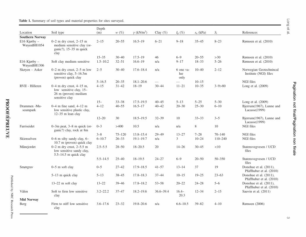
Table 1. Summary of soil types and material properties for sites surveyed.
Location Soil typeDepth(m) w (%) g (kN/m3) Clay (%) Ip (%) su (kPa) St References
Southern NorwayE16 Kjørby –WøyenBH1054
0–2 m dry crust, 2–15 mmedium sensitive clay (or-ganic?), 15–35 m quickclay
2–15 20–55 16.5–19 6–21 9–18 35–45 8–23 Rømoen et al. (2010)
15–35 30–40 17.5–19 46 6–9 20–55 >30 Rømoen et al. (2010)E16 Kjørby –WøyenBH1306
Soft clay medium sensitive 1.5–10.2 32–51 16.6–19 n/a 9–17 18–33 5–26 Rømoen et al. (2010)
Skøyen – Asker 0–2 m dry crust, 2–5 m lowsensitive clay, 5–16.5m(proven) quick clay
2–5 30–40 17.6–18.4 n/a 6 one va-lueonly
10–40 2–12 Norwegian GeotechnincalInstitute (NGI) files
5–16.5 20–35 18.1–20.6 — — 10–15 NGI filesRVII - Hilleren 0–4 m dry crust, 4–15 m,
low sensitive clay, 15–26 m (proven) mediumsensitive clay
4–15 31–42 18–19 30–44 11–21 10–35 3–9>80 Long et al. (2009)
15– 33–38 17.5–19.5 40–45 5–13 5–25 5–30 Long et al. (2009)Drammen -Mu-seumpark
0–4 m fine sand, 4–12 mlow sensitive plastic clay,12–35 m lean clay
4–12 40–55 16.5–17 40–42 20–30 25–30 6–10 Bjerrum(1967), Lunne andLacasse(1999)
12–20 30 18.5–19.5 32–39 10 33–33 3–5 Bjerrum(1967), Lunne andLacasse(1999)
Farriseidet 0–3m peat, 3–8 m quick (or-ganic?) clay, rock at 8m
0–3 >400 10.5 n/a n/a 8 10 NGI files
3–8 75–120 13.8–15.4 29–49 13–27 7–28 70–140 NGI filesSkienselven 0–6 m silty sandy clay, 6–
10.7 m (proven) quick clay6–10.7 26–33 19.1–19.7 n/a 3 10–24 110–240 NGI files
Månejordet 0–2 m dry crust, 2–5.5 mlow sensitive sandy clay,5.5–14.5 m quick clay
2.5–5.5 28–50 18–20.5 20 14–26 30–45 <10 Statensvegvesen / UCDfiles
5.5–14.5 25–40 18–19.5 24–27 6–9 20–50 50–350 Statensvegvesen / UCDfiles
Smørgrav 0–5 m soft clay 0–5 27–42 17.9–18.5 41–57 13–14 37 19 Donohue et al. (2011),Pfaffhuber et al. (2010)
5–13 m quick clay 5–13 38–45 17.8–18.3 37–44 10–15 19–25 23–63 Donohue et al. (2011),Pfaffhuber et al. (2010)
13–22 m soft clay 13–22 39–46 17.8–18.2 53–58 20–22 24–28 5–6 Donohue et al. (2011),Pfaffhuber et al. (2010)
Vålen Soft to firm low sensitiveclay
3.2–22.2 37–47 18.2–19.6 36.6–39.4 16.4–20.3
12–34 2–15 Sauvin et al. (2011)
Mid NorwayBerg Firm to stiff low sensitive
clay3.6–17.6 23–32 19.8–20.6 n/a 6.6–10.5 39–82 4–10 Rømoen (2006)
Pag
inationno
tfinal/P
aginatio
nno
nfinale
Longet
al.3
Publishedby
NRCResearch
Press
PROOF/É
PREUVE

ception isVålen where the work was done by the NorwegianGeotechnical Institute (NGI). The work at the six sites in midNorway and northern Norway was performed by the Geolog-ical Survey of Norway (NGU).Similar techniques were used at all sites. For the APEX–
UCD surveys, data was acquired using a multi-electrodeCampus Tigre resistivity meter with a 32-takeout multi-corecable and 32 conventional stainless steel electrodes. An elec-trode spacing of 3 m was used as the default. However atseveral of the sites a 5 m spacing was also used to providedeeper data (e.g., at E16 Kjørby – Wøyen and RVII- Hille-ren). As the subsurface layers were not expected to deviatesignificantly from the horizontal, a four-electrode Wenner ar-ray configuration was used to acquire multiple readings foreach ERT profile. The Wenner array also generally providesa good signal to noise ratio (Donohue et al. 2011).The work at Vålen employed a Terrameter LS with four
cables of 21 takeouts (81 active electrodes). A roll-along gra-dient configuration with 2 and 4 m electrode spacing wasused to acquire the data, leading to a total profile length of160 to 320 m.The equipment used by NGU was the Lund system, devel-
oped by Dahlin (1993), comprising a relay box (ABEMES10–64) and four multi-electrode cables and 81 active stain-less steel electrodes, controlled by an ABEM Terrameter SAS4000. The distance between the electrodes was generally 5 mand occasionally 2 or 10 m. Both the Wenner and Gradientarray systems were used. The Gradient array can yield up toseven times more data than the Wenner array in a shortertime and thus can be useful for examining lateral changes inresistivity (Dahlin and Zhou 2006).
Data processingIn all cases the data processing and inversion was carried
out using the software Res2Dinv (Loke 2007). This softwareuses a forward-modelling subroutine to calculate the apparentresistivity values and a nonlinear least-squares optimizationtechnique (Loke and Barker 1996). In a study of syntheticdata to represent marine clays, Reiser et al. (2010) showedthat “smooth” inversion with a vertical–horizontal filter of0.5 resulted in the most accurate inversion models. “Smooth”inversion was generally used as standard (Solberg et al.2012), but it was found that “robust” inversion can give bet-ter definition of sharp boundaries, e.g., between clay andbedrock (Reiser et al. 2010).The least-squares equations resulting from the inversion
process were solved using the Gauss–Newton method. Asthere occasionally was a large subsurface resistivity contrast,the Gauss–Newton method was used for the first two to threeiterations, then the quasi-Newton method was employed. Thelatter allows an approximate solution within a pre-definedconvergence limit. This was found to provide the best com-promise between computational time and accuracy (Lokeand Dahlin 2002). Most inversions performed converged toroot mean square (RMS) errors of less than 6% within fiveto six iterations and the final RMS errors were usually lessthan 1.5%.
Soil sampling and testingIn Norway, the standard site investigation procedure is to
recover continuous piston samples of unconsolidated overbur-Tab
le1(concluded).
Location
Soiltype
Depth
(m)
w(%
)g(kN/m
3 )Clay(%
)I p
(%)
s u(kPa)
S tReferences
Rissa
H3-H4
Softto
firm
clay
medium
sensitive
2.2–
11.1
22–42
18.1–20
37–57
6–14
12–38.5
2–14
.1Gregersen
(198
1),A
asland
(2010),L
’Heureux
etal.
(2011a)
Rissa
H5
Softquickclay
2.4–
10.9
28–40
18.3–19.8
477–
129–
3813–6
1.5
Aasland
(2010)
Rød
deFirm
silty
clay
occasionally
quick
1.5–
20.5
26–33
19.1–19.7
30–47
n/a
28–71
2.5–37
(65–235
occasionally)
Ottesen(200
9),S
olberg
etal.(2011b)
Buv
ika
Firm
quickclay
2.4–
23.4
30–39
18.4–19.3
28–47
12–17
20–80
15–3
50So
lberget
al.(2008),
Helle
(2004)
North
Trønd
elag
andNorthernNorway
Finneidfjord
Softoccasionally
sandyclay
2.5–
11.5
28–40
18.4–21.8
9–17
n/a
12–27
3–11
Lecom
teet
al.(2008
a,2008
b);L’H
eureux
etal.
(2011b)
Kattm
arka
Softsilty
clay
occasionally
quick
1.2 –
19.6
26–38
18.5–19.7
24–35
6–9
9–48
4.8–67
Solberget
al.(2011
a),
Nordalet
al.(200
9),
Multiconsult(2009)
Note:
n/a,
notavailable.
Additional
references:Longet
al.(2009);Bjerrum
(1967);Lunne
andLacasse
(1999);Røm
oen(2006);Gregersen
(1981);Aasland
(2010);Ottesen(2009);Lecom
teet
al.(2008
b);
Solberget
al.(2011);Helle
(2004);Multiconsult(2009).
Pagination not final/Pagination non finale
4 Can. Geotech. J. Vol. 49, 2012
Published by NRC Research Press
PROOF/ÉPREUVE

den material and to subsequently subject each of the samplesto routine index testing as well as more advanced strengthand compression tests if these are required. In most of thesites studied here the sampling technique involved use of theNGI 54 mm composite sampler (Andresen and Kolstad1979), which is the most common sampler used in Norway.It is a composite piston sampler using plastic inner tubes.The displacement method is used, where the sampler ispushed down to the desired depth without pre-augering.Long et al. (2009) describe a detailed study into the qualityof samples retrieved using this procedure and demonstratethat the resulting quality is acceptable for routine andmedium-sized projects. At a number of sites in the mid Nor-way region the version of the sampler that uses a thin-walled54 mm tube only was used.Index testing normally comprises determination of water
content, bulk density, sensitivity using the Swedish fall cone,and unconfined compression testing on all recovered pistonsamples. A limited number of plasticity, particle density,grain size, salt content, and organic content determinationsare also usually made. Specifically, salt content is determinedby expelling pore water in a centrifuge and using a correla-tion between measured electrical conductivity and salinity.Clay (particles less than 0.002 mm in size) and silt (particlesbetween 0.002 and 0.06 mm in size) are determined using ei-ther a hydrometer or the falling drop method (Moum 1965).Fall cone testing makes use of the Swedish fall cone. In Nor-way, fall cone data are interpreted according to NS8015(Norwegian Standardisation System 1988), which is largelybased on the Swedish Geotechnical Institute (SGI 1946) cali-bration with some local modifications–additions.
Results and correlationsInverted resistivity values were extracted from the Re-
s2Dinv data files. A one-dimensional (1D) plot of resistivityversus depth at the location of the relevant borehole wasmade and the results compared with the geotechnical param-eters obtained from piston samples extracted from the samedepth. In each case a resistivity profile and a matching bore-hole, i.e., a borehole on the same line as the resistivity sec-tion or located at most 5 m from the section, was used.
Resistivity and salt content of pore fluidThe relationship between resistivity and salt content of the
pore fluid is shown in Fig. 2. Unfortunately as salt content is
not measured routinely in all investigations, the amount ofdata is relatively limited. As expected the link between thesetwo parameters is strong. Resistivity decreases rapidly withincreasing salt content and reaches a low value of about5 U·m and becomes more or less constant once the salt con-tent exceeds approximately 8 g/L. The exponential trendlineshows a relatively good coefficient of correlation, R2, valueof 0.8.In the past authors such as Bjerrum(1954) and Rosenqvist
(1955) have suggested that clay becomes quick (i.e., sensitiv-ity St> 30 and remoulded shear strength sur< 0.5 kPa) whenthe salt content is less than 5 g/L. Subsequently Torrance(1974) suggested the limit should be 2 g/L. The plot of sen-sitivity versus salinity of the pore fluid, shown in Fig. 3,shows that although all of the quick clay data points have asalt content less than 5 g/L, there are also a significant num-ber of data points with a salt content less than 2 or 5 g/L forwhich the sensitivity is less than 30. In addition, Andersson-Sköld et al. (2005) measured a salinity of 5.6 g/L in Swedishquick clay. Nonquick marine clay may also contain very lowsalt content due to continued leaching or weathering.This illustrates that although salt content of the pore fluid
Table 2. Typical resistivity values for various materials (modified from Solberg et al. 2012).
Resistivity (U·m) Main characterization Description1–10 Unleached marine clay
depositsThe clay has been exposed to little leaching since deposition. The pores in theclay still contain salt water, which stabilize the structure. Because of thelarge concentration of ions in the pore water, the conductivity of the clay isgood, and thus the resistivityvalues are low
10–100 Leached clay deposits Sensitive clay develops as groundwater leaches ions from the marine clay. Theelectrical conductivity of the deposit is still high, but not as good as for theunleached marine clay. Other sediment features can give resistivity values si-milar to those of quick clay: further leached marine clay (not quick any-more), silt, and fine-grained till
>100 Dry crust clay deposits,coarse sediments, (bed-rock)
Dry crust clay; remoulded, dry clay from quick-clay landslides; and coarsermaterials like sand and gravel will have higher resistivity values than marineclay. Most bedrock types will have values of several thousand U·m.
Fig. 2. Resistivity and salt content of pore fluid.
Pagination not final/Pagination non finale
Long et al. 5
Published by NRC Research Press
PROOF/ÉPREUVE

is a very important controlling factor, sensitivity of marineclay is also influenced by other factors (Mitchell 1993).
Resistivity and clay contentThe relationship between resistivity and clay content is
shown in Fig. 4. There is a relatively strong correlation be-tween the two properties, with resistivity decreasing with in-creasing clay content. This finding is as expected as clayparticles facilitate surface conductance of electrical current.Those sites with relatively low clay content (e.g., the compa-ratively silty materials at Finneidfjord, Kattmarka, andRødde) show high resistivity values. Beyond clay content of
about 40% (by mass) the resistivity values are generally low.The polynomial trendline shown has a reasonable R2 value of0.59.
Resistivity and plasticity indexA similar pattern, to that of clay content, emerges in the
plot of resistivity against plasticity index (Ip) in Fig. 5. Notethere are unfortunately relatively few data points for high-plasticity clays with Ip> 20%. Again there is a reasonablystrong trend of reducing resistivity due to increasing Ip. Thisis consistent for the finding for clay content above, as Ip willincrease with increasing clay content. However Ip in sensitiveclays varies not only with the grain size of the soil, but also
Fig. 3. Sensitivity and salt content of the pore fluid.
Fig. 4. Resistivity and clay content.
Fig. 5. Resistivity and plasticity index.
Fig. 6. Resistivity and remoulded shear strength.
Pagination not final/Pagination non finale
6 Can. Geotech. J. Vol. 49, 2012
Published by NRC Research Press
PROOF/ÉPREUVE

with the intensity of the leaching. For example, Bjerrum(1954) showed that leaching by fresh water of a Norwegianmarine clay resulted in a drop in the liquid limit from 45%to 25%, while the plastic limit shows a much lower reductionfrom about 20% to 17%. Hence the sensitive clays may showa relatively lower Ip than a similar nonsensitive clay, thusmaking any correlation between resistivity and Ip more com-plex.Nonetheless for the data presented here beyond an Ip value
of about 20%, corresponding to the upper limit of mediumplasticity (Norsk Geoteknisk Forening (NGF 1982)), the re-sistivity values are low (≈ 5 U·m) and more or less constant.For the low-plasticity materials the resistivity values are gen-erally higher, but are more scattered, probably due to the rea-sons discussed above. Some attempts were made to fit a
trendline through the data, but the resulting R2 value waspoor.
Resistivity and remoulded shear strengthAs remoulded shear strength (sur) is directly related to the
salt content of the pore fluid, one would expect a strong linkbetween resistivity and sur (as measured by the fall cone). Inaddition, leaching decreases the liquid limit of marine claysand consequently the remoulded shear strength (Mitchell andSoga 2005). As seen in Fig. 6, resistivity decreases rapidlywith increasing remoulded shear strength and becomes moreor less constant when the sur value exceeds 4 kPa. The rea-
Fig. 7. Resistivity and remoulded shear strength less than 0.5 kPa.
Fig. 8. Resistivity and sensitivity.
Fig. 9. Resistivity and bulk unit weight.
Fig. 10. Resistivity and water content.
Pagination not final/Pagination non finale
Long et al. 7
Published by NRC Research Press
PROOF/ÉPREUVE

sons for the relatively high values at the RVII – Hilleren siteare unclear and warrant further study. Remoulded shearstrength values in silty materials needs to be treated with cau-tion as the shearing action may not be totally undrained,leading to possible relatively high values.In Fig. 7, the focus is on those values where sur is less than
0.5 kPa, which is the threshold for quick clay according toNGF (1982). There is a clear trend of increasing resistivitywith decreasing sur. This is consistent with the fact that surwill decrease with increasing intensity of leaching. Solberget al. (2012) reviewed a large body of data and found that10 to 100 U·m represented the resistivity range for quickclay. Although most of the data discussed here is within thisrange, some of the sites with relatively high silt content (e.g.,Skienselven, Rødde, and Kattmarka) exhibit significantlyhigher resistivity values up to 150 U·m.
Resistivity and sensitivitySensitivity is the ratio of peak (su) to remoulded shear
strength (sur). Unfortunately the values of su and sur are notunique and will vary with the test type, mode of deformation,stress conditions, and strain rate, amongst other factors. Inturn, the absolute value of sensitivity will depend on the testused. For consistency, in this study the results from only theSwedish fall cone tests have been used. This test is the onemost widely used in Scandinavia. Leaching will have a muchstronger effect on sur than su. In fact, the su value will belargely unaffected. Thus a good relationship between resistiv-ity and sensitivity is to be expected.Resistivity values are plotted against sensitivity (from the
fall cone) in Fig. 8. There is a good relationship between thetwo properties, with resistivity increasing more or less line-arly with sensitivity. The increase in scatter of the data withincreasing St is due to the decreasing accuracy of the fallcone measurements.The high values for Skienselven, Rødde, and Kattmarka
are due to the silty nature of the material as presented above.The relatively high values for RVII need to be investigatedfurther.
Resistivity and bulk unit weightThe relationship between resistivity and bulk unit weight is
shown in Fig. 9. Intuitively one would expect resistivity todecrease with increasing unit weight (or density) as the par-ticles are forced closer together. For the bulk of the data,where the resistivity is less than 50 U·m, there is some weaktendency for decreasing resistivity with increasing bulk unitweight. However the trends are far from clear and vary fromsite to site. For example, the Rissa data follows the expectedtrend whereas the Smørgrav data shows the opposite ten-dency. Some sites, for example Skøyen – Asker, show rela-tively constant resistivity for a range of unit weight values.The higher resistivity values recorded for the sites at
Skienselven, Finneidfjord, and Kattmarka fall outside thegeneral trend and can be attributed to the silty nature of thesematerials. The Farriseidet site shows low bulk unit weightvalues due to the organic nature of the material.It would seem that, although bulk unit weight plays a role
in the resulting measured resistivity, its influence is out-weighed by other factors.
Resistivity and water contentInverted resistivity values are plotted against water content
in Fig. 10. There is no clear pattern in the plot, even for themain body of the data where the resistivity is less than50 U·m. Similar to the relationship with bulk unit weight,the values for the materials with either high silt or –sand con-tent or high organic content fall well away from the mainbody of the data.
Discussion
Resistivity and geotechnical propertiesThe data presented above shows that the measured resistiv-
ity values depend on a number of interrelated factors. It isdifficult to separate the influence of each individual parame-ter. In Fig. 8, for example, an attempt has been made to dothis, where the clay content values have been superimposedon the plot of resistivity against sensitivity. Although thehigher clay content materials correspond to the lower resistiv-ity values, there is insufficient data or insufficient trends toplot, e.g., contours of clay content on the diagram.The data shows that resistivity is strongly influenced by
the salt content of the pore fluid and also influenced signifi-cantly by the clay content and plasticity of the material. Itcould be argued that the data for clay content and plasticityindex in Figs. 4 and 5 merely reflect reducing salt content.However these figures contain more data than shown inFig. 6 and include data for sites where the remoulded shearstrength (and hence salinity) are similar.For the data available, no relationship was found between
resistivity and water content. However as the range of valuesstudied here is relatively limited, and many other studies haveshown the importance of water content on measured resistiv-ity, this finding will not be universally applicable.
ERT versus RCPTUThe data presented in this study compares point data (lab-
oratory measurements) with larger soil volumes (geophysicaldata) and scale effects may therefore arise. The influence ofsuch scale effects may be studied by comparing ERT datawith the previously mentioned resistivity cone penetrationtest (RCPTU). The latter involves an 80 cm long, 4.4 cm di-ameter module on which four ring electrodes are mounted.The two outer rings apply current and the two inner ringsmeasure the voltage. The distance between the two outerrings is approximately 20 cm, and thus the RCPTU measure-ments relate to a small, relatively homogenous, body of soilsimilar in scale to a soil sample. Unlike ERT data, RCPTUresults do not need to be inverted. Pfaffhuber et al. (2010)illustrate how RCPTU data can be used successfully to con-strain an ERT inversion process.There is some evidence that RCPTUs will give slightly
lower resistivity values in the high sensitive clay zones.Schälin and Tornborg (2009) found RCPTU measurementsin highly sensitive clay could be 2 to 3 Ω·m lower than ERTinverted data. This is also in agreement with the work of Fu-kue et al. (1999) who showed that remoulded clay has betterconductivity than undisturbed clay, as the breakage of thechemical bonding between the clay particles will decreasethe resistivity. Sauvin et al. (2011) found good agreement be-tween ERT and RCPTU data for the Vålen research site.
Pagination not final/Pagination non finale
8 Can. Geotech. J. Vol. 49, 2012
Published by NRC Research Press
PROOF/ÉPREUVE

Dahlin et al. (2004) also found good correlation betweenERT and RCPTU data, but their study did not include quickclays.Figure 11 shows a comparison of ERT and RCPTU data
from tests sites at Rissa (Figs. 11a and 11b) and Rødde(Fig. 11c). The data are taken from Solberg et al. (2010) andSolberg et al. (2012), respectively. The two sets of data forRissa show that the RCPTU data can give either lower orhigher resistivity values than for the ERT data. Overall, therelationship between the two sets of data at both sites is verygood and confirms the reliability and applicability of theERT data for the present purposes.
Possible methodical weaknesses with ERTTwo-dimensional ERT data measured at the surface may
suffer from some methodical weaknesses. Effects of three-di-mensional geology may influence the measured resistivityvalues and consequently the inverted 2D resistivity section.In addition, the principles of equivalence and suppressionmay influence the inverted sections (Reynolds 2011). Sup-pression appears when resistivity in one layer lies betweenthe resistivity of the surrounding layers while equivalence ap-pears on ascending or descending resistivity towards thedepth. Anisotropic resistivity may also influence the resultswhen data from different methods are compared. The effectsof these weaknesses are nonunique inversion results.Nonetheless, the comparison between ERT and RCPTU
data, shown in Fig. 11, confirms there is a good correlationbetween 2D surface and 1D borehole resistivity data. How-ever, in detail there are deviations that make it necessary tohave great and partly overlapping intervals for the resistivityin different materials in an interpretational model. Thepresent study will give a better understanding of what kindof geotechnical information can be extracted from the resis-tivity data.
Conclusions and recommendationsThe ultimate objective of this work was to provide assis-
tance for practicing engineers in the interpretation of resistiv-ity surveys in glacio-marine and marine clay areas bystudying the influence of basic geotechnical parameters onresistivity values from 2D measurements. It was found that
1. There is a strong link between resistivity and both saltcontent of the pore fluid and remoulded shear strength.Resistivity decreases rapidly with increasing salt contentor remoulded shear strength. The resistivity values be-come more or less constant if the salt content is greaterthan about 8 g/L and the remoulded shear strength isgreater than 4 kPa.
2. There is a trend of decreasing resistivity with increasingclay content and plasticity index. Although these trendsare not conclusive, for high-plasticity clays, with Ip≈ 20%and clay content >50%, the measured resistivity valuesare very low (≈ 5 U·m).
3. It would seem that, although bulk density plays a role inthe resulting measured resistivity, its influence is out-weighed by other factors such as salt content of the porefluid and clay content.
4. The data presented here suggest that the range of resistiv-ity values corresponding to quick clay is 10 to 100 U·m,and this is consistent with other published limits. ThusERT surveys alone are not sufficient for mapping quickclay and need to be supplemented with conventional dril-ling and sampling.
5. A comparison of ERT and RCPTU data show comparabletrends and similar resistivity values. This confirms thatthe ERT data, which represent bulk resistivity, can givesufficiently accurate information on local soil conditions.For future work it would be useful to
Fig. 11. Comparison of ERT and RCPTU for (a, b) Rissa and (c) Rødde.
Pagination not final/Pagination non finale
Long et al. 9
Published by NRC Research Press
PROOF/ÉPREUVE

• Extend the range of clays studied to those of higher plas-ticity.
• Carry out additional work on silt sites to examine thecontrolling factors on resistivity for these materials.
ReferencesAasland, R. 2010. Kartlegging av kvikkleire med 2D resistivitet og
RCPT i Rissa. Masteroppgave, Institutt for Geoteknikk. NTNU,Trondheim, Norway. [In Norwegian.]
Andersson-Sköld, Y., Torrance, J.K., Lind, B., Odén, K., Stevens, R.L., and Rankka, K. 2005. Quick clay - A case study of chemicalperspective in southwest Sweden. Engineering Geology, 82(2):107–118. doi:10.1016/j.enggeo.2005.09.014.
Andresen, A., and Kolstad, P. 1979. The NGI 54mm samplers forundisturbed sampling of clays and representative sampling ofcoarser materials. In Proceedings of the International Symposiumon Soil Sampling, Singapore. pp. 13–21.
Bjerrum, L. 1954. Geotechnical properties of Norwegian marineclays. Géotechnique, 4(1): 49–69.
Bjerrum, L. 1967. Engineering geology of Norwegian normallyconsolidated marine clays as related to settlement of buildings.Géotechnique, 17(2): 81–118.
Dahlin, T. 1993. On the automation of 2D resistivity surveying forengineering and environmental applications. Ph.D. thesis, Depart-ment of Engineering Geology, Lund University of Technology,Sweden.
Dahlin, T., and Zhou, B. 2006. Multiple-gradient array measurementsfor multi-channel 2D resistivity imaging. Near Surface Geophy-sics, 4: 113–123.
Dahlin, T., Palm, M., and Garin, H. 2004. Combined resistivityimaging and RCPT for geotechnical preinvestigation. In Proceed-ings of the 14th NGM, Nordic Geotechnical Meeting, Ystad,Sweden. pp. C81–C88.
Dahlin, T., Larsson, R., Leroux, V., and Rankka, K. 2005. Resistivityimaging for mapping of quick clays for landslide risk assessment.In Proceedings of Near Surface 2005 – 11th European Meeting ofEnvironmental and Engineering Geophysics, Palermo, Italy.
Donohue, S., Long, M., O’Connor, P., Eide-Helle, T., Pffaffhuber, A.A., and Rømoen, M. 2011. Geophysical mapping of quick clay: acase study from Smørgrav, Norway. Near Surface Geophysics, [Inpress.]
Fukue, M., Minato, T., Horibe, H., and Taya, N. 1999. The micro-structures ofclay given by resistivity measurements. EngineeringGeology 54(1–2): 43–53. doi:10.1016/S0013-7952(99)00060-5.
Geertsema, M., and Torrance, J.K. 2005. Quick clay from the MinkCreek landslide near Terrace, British Columbia: Geotechnicalproperties, mineralogy, and geochemistry. Canadian GeotechnicalJournal, 42(3): 907–918. doi:10.1139/t05-028.
Gregersen, O. 1981. The quick clay landslide at Rissa, Norway.Norwegian Geotechnical Institute Publication 135. NorwegianGeotechnical Institute. pp. 1–6.
Helle, T.E. 2004. E39 Vigda, Buvika, Profile 3 - Natural Slope.Projectoppgave, Institutt for Geoteknikk. NTNU, Trondheim,Norway.
L’Heureux, J.-S., Eilertsen, R.S., Glimsdal, S., Issler, D., Solberg, I.-L., and Harbitz, C.B. 2011a. The 1978 quick clay landslide atRissa, mid Norway: subaqueous morphology and tsunamisimulations. In Proceedings of the 5th International Symposiumon Submarine Mass Movements and Their Consequences. Editedby Y. Yamada et al., Kyoto, Japan. Springer Science + BusinessMedia.
L’Heureux, J.-S., Longva, O., Steinar, A., Hansen, L., Vardy, M.E.,Vanneste, M., et al. 2011b. Identification of weak layers and their
role for the stability of slopes at Finneidfjord, Northern Norway. InProceedings of the 5th International Symposium on SubmarineMass Movements and Their Consequences. Edited by Y. Yamadaet al. Kyoto, Japan. Springer Science + Business Media. pp. 321–330.
Lecomte, I., Bano, M., Hamran, S.-E., Dalsegg, E., and Nielsen, K.M. 2008a. Mapping quick clay sites for geohazard assessment: theFinneidfjord case study, Norway. In Proceedings of Near Surface2008 - 14th European Meeting of Environmental and EngineeringGeophysics, Krakόw, Poland. Paper B19.
Lecomte, I., Bano, M., Hamran, S.-E., Dalsegg, E., Nielsen, K.M.,Nielsen, M.H., et al. 2008b. Submarine slides at Finneidfjord(Norway): geophysical investigations. In Proceedings of the 21stEEGS Symposium on the Application of Geophysics toEngineering and Environmental Problems. pp. 376–388.
Löfroth, H., Suer, P., Dahlin, T., Leroux, V., and Schälin, D. 2011.Quick clay mapping by resistivity - Surface resistivity, CPTU-Rand chemistry to complement other geotechnical sounding andsampling. In Statensgeotekniskainstitut, SGI. Götaälvutredningen.GÄU. Delrapport 30. Swedish Geotechnical Institute, Linköping,Sweden.
Loke, M.H. 2007. Res2DInv ver. 3.56.Geoelectrical imaging 2D and3D. Instruction manual.Geotomo Software.
Loke, M.H., and Barker, R.D. 1996. Rapid least-squares inversion ofapparent resistivity pseudosections by quasi Newton method.Geophysical Prospecting, 44(1): 131–152. doi:10.1111/j.1365-2478.1996.tb00142.x.
Loke, M.H., and Dahlin, T. 2002. A comparison of Gauss-Newtonand quasi Newton methods in resistivity imaging inversion.Journal of Applied Geophysics, 49(3): 149–162. doi:10.1016/S0926-9851(01)00106-9.
Long, M., El Hadj, N., and Hagberg, K. 2009. Quality ofconventional fixed piston samples of soft clay. Journal ofGeotechnical and Geoenvironmental Engineering, 135(2): 185–198. doi:10.1061/(ASCE)1090-0241(2009)135:2(185).
Longva, O., Janbu, N., Blikra, L.H., and Bøe, R. 2003. The 1996Finneidfjord slide: seafloor dynamics. In Proceedings of the 1stInternational Symposium on Submarine Mass Movements andtheir Consequences, EGS-AGU-EUG Joint Meeting. Nice, France.Kluwer Academic Publishers. pp. 531–538.
Lundström, K., Larsson, R., and Dahlin, T. 2009. Mapping of quickclay formations using geotechnical and geophysical methods.Landslides, 6(1): 1–15. doi:10.1007/s10346-009-0144-9.
Lunne, T., and Lacasse, S. 1999. Geotechnical characterisation of thelow plasticity Drammen clay. In Proceedings of the InternationalSymposium on Characterisation of Soft Marine Clays - Bothken-nar, Drammen, Quebec and Ariake clays. Edited by T. Tsuchidaand A. Nakase. Yokosuka: A.A. Balkema, Rotterdam. pp. 33–56.
Mitchell, J.K. 1993. Fundamentals of soil behavior. Wiley, New York.Mitchell, J.K., and Soga, K. 2005. Fundamentals of Soil Behaviour.
John Wiley and Sons, Hoboken, New Jersey.Moum, J. 1965. Falling drop used for grain-size analysis of fine
grained materials. Sedimentology, 5(4): 343–347. doi:10.1111/j.1365-3091.1965.tb01566.x.
Multiconsult. 2009. Kattmarken boligfelt, grunnundersøkelser. Geo-teknisk datarapport med orienterende geoteknisk vurdering.Multiconsult Report No. 413456–1, dated 06.03.2009. [InNorwegian.]
NGF. 1982. Veilding for symboler og definisjoner i goeteknikk -presentasjon av geotekniske undersøkelser. Norwegian Geotechni-cal Society (Norsk Geoteknisk Forening), Oslo. [In Norwegian.]
Nordal, S., Alén, C., Emdal, A., Jendeby, L., Lyche, E., and Madshus,C. 2009. Skredet i Kattmarkvegen i Namsos 13. mars 2009.Rapport fra undersøkelsesgruppe satt ned av Samferdselsdeparte-
Pagination not final/Pagination non finale
10 Can. Geotech. J. Vol. 49, 2012
Published by NRC Research Press
PROOF/ÉPREUVE

mentet. Institutt for Bygg, Anlegg og Transport, Faggruppe forGeoteknikk, NTNU. [In Norwegian.]
Norwegian Standardisation System. 1988. Falling cone tests.Standard NS 8015. Norwegian Standardisation System, Oslo,Norway.
Ottesen, H.B. 2009. CPTU med resistivitietsmåling. Masteroppgave,Institutt for Geoteknikk. NTNU, Trondheim, Norway. [InNorwegian.]
Pfaffhuber, A.A., Bastani, M., Cornèe, S., Rømoen, M., Donohue, S.,Helle, T.E., et al. 2010.Multi - method high resolution geophysicaland geotechnical quick clay mapping. In Proceedings of NearSurface 2010 - 16th European Meeting of Environmental andEngineering Geophysics, Zurich.
Reiser, F., Dahlin, T., Rønning, J.S., and Solberg, I.-L. 2010.Resistivity modelling for clay layer characterisation, possibilitiesand limitations. Geological Survey of Norway (NGU), Trondheim,Norway. Report 2010.047.
Reynolds, J.M. 2011. An introduction to applied and environmentalgeophysics. Wiley - Blackwell, UK.
Rømoen, M. 2006. Evaluation of stability and deformations in theBerg area Trondheim. Masteroppgave, Institutt for Geoteknikk.NTNU, Trondheim.
Rømoen, M., Pffaffhuber, A.A., Karlsrud, K., and Helle, T.E.2010.“Resistivity on marine sediments retrieved from RCPTUsoundings: a Norwegian case study. In Proceedings of the 2ndInternational Symposium on Cone Penetration Testing (CPT ’10).Edited by P.K. Robertson and P.W. Mayne. Omnipress, HuntingtonBeach, California. pp. 289–296.
Rosenqvist, I.T. 1955. Investigations in the clay-electrolyte-watersystem. Norwegian Geotechnical Institute Publication 9. Norwe-gian Geotechnical Institute.
Sauvin, G., Bazin, S., Vanneste, M., Lecomte, I., and Pfaffhuber, A.A. 2011. Towards joint inversion / interpretation for landslide-prone areas in Norway - integrating geophysics and geotechnique.In Proceedings of Near Surface 2011 - 17th European Meeting of
Environmental and Engineering Geophysics. Leicester, UK. PaperE11.
Schälin, D., and Tornborg, J. 2009. Evaluation of CPT-R andresistivity measurements in quick clay area. M.Sc. thesis,Department of Civil and Environmental Engineering, Division ofGeoEngineering, Chalmers University of Technology, Göteborg,Sweden.
SGI. 1946. Korfattat compedium i geoteknikk Meddelande Nr. 1.Swedish Geotechnical Institute, (SGI),Stockholm. [In Swedish.]
Solberg, I.-L., Rønning, J.S., Dalsegg, E., Hansen, L., Rokoengen,K., and Sandven, R. 2008. Resistivity measurements as a tool foroutlining quick-clay extent and valley-fill stratigraphy: a feasibilitystudy from Buvika, central Norway. Canadian GeotechnicalJournal, 45(2): 210–225. doi:10.1139/T07-089.
Solberg, I.-L., Aasland, R., Dalsegg, E., Hansen, L., L’Heureux, J.-S.,and Rønning, J.S. 2010. Kvikkleireproblematikk i Rissa - bruk avresistivitetsmålinger. Fjellsprengningsdagen, Bergmekanikk- ogGeoteknikkdagen. Norsk Geoteknisk Forening, Oslo, Norway.Chapter 37. [In Norwegian.]
Solberg, I.-L., Dalsegg, E., and Hansen, L. 2011. Resistivitetsmå-linger for løsmassekartlegging i Namsos, Nord-Trøndelag. Dataogtolkninger Geological Survey of Norway (NGU), Trondheim,Norway. Report 2010.046. [In Norwegian.]
Solberg, I.-L., Hansen, L., Rønning, J.S., Haugen, E.D., Dalsegg, E.,and Tønnesen, J.F. 2012. Combined geophysical and geotechnicalapproach to ground investigations and hazard zonation of a quickclay area, mid Norway. Bulletin of Engineering Geology and theEnvironment, 71(1): 119–133. doi:10.1007/s10064-011-0363-x.
Torrance, J.K. 1974. A laboratory investigation of the effect ofleaching on the compressibility and shear strength of Norwegianmarine clays. Géotechnique, 24(2): 155–173. doi:10.1680/geot.1974.24.2.155.
Torrance, J.K., and Ohtsubo, M. 1995. Ariake Bay quick clays: Acomparison with the general model. Soils and Foundations, 35(1):11–19. doi:10.3208/sandf1972.35.11.
Pagination not final/Pagination non finale
Long et al. 11
Published by NRC Research Press
PROOF/ÉPREUVE