Regional Tectonics and Seismicity of Eastern Nebraska ...
115
University of Nebraska - Lincoln DigitalCommons@University of Nebraska - Lincoln Conservation and Survey Division Natural Resources, School of 11-1981 Regional Tectonics and Seismicity of Eastern Nebraska, Annual Report, July 1980–June 1981 R. R. Burche University of Nebraska-Lincoln Follow this and additional works at: hp://digitalcommons.unl.edu/conservationsurvey Part of the Geology Commons , Geomorphology Commons , Hydrology Commons , Paleontology Commons , Sedimentology Commons , Soil Science Commons , and the Stratigraphy Commons is Article is brought to you for free and open access by the Natural Resources, School of at DigitalCommons@University of Nebraska - Lincoln. It has been accepted for inclusion in Conservation and Survey Division by an authorized administrator of DigitalCommons@University of Nebraska - Lincoln. Burche, R. R., "Regional Tectonics and Seismicity of Eastern Nebraska, Annual Report, July 1980–June 1981" (1981). Conservation and Survey Division. 6. hp://digitalcommons.unl.edu/conservationsurvey/6
Transcript of Regional Tectonics and Seismicity of Eastern Nebraska ...

University of Nebraska - LincolnDigitalCommons@University of Nebraska - Lincoln
Conservation and Survey Division Natural Resources, School of
11-1981
Regional Tectonics and Seismicity of EasternNebraska, Annual Report, July 1980–June 1981R. R. BurchettUniversity of Nebraska-Lincoln
Follow this and additional works at: http://digitalcommons.unl.edu/conservationsurvey
Part of the Geology Commons, Geomorphology Commons, Hydrology Commons,Paleontology Commons, Sedimentology Commons, Soil Science Commons, and the StratigraphyCommons
This Article is brought to you for free and open access by the Natural Resources, School of at DigitalCommons@University of Nebraska - Lincoln. Ithas been accepted for inclusion in Conservation and Survey Division by an authorized administrator of DigitalCommons@University of Nebraska -Lincoln.
Burchett, R. R., "Regional Tectonics and Seismicity of Eastern Nebraska, Annual Report, July 1980–June 1981" (1981). Conservationand Survey Division. 6.http://digitalcommons.unl.edu/conservationsurvey/6

NUREG/CR-2411
Regional Tectonics and Seismicity of Eastern Nebraska
Annual Report July 1980 - June 1981
R. R. Burchett
Institute of Agriculture and Natural Resources University of Nebraska-Lincoln
Prepared for U.S. Nuclear Regulatory Commission

NOTICE
This report was prepared as an account of work sponsored by an agency of the United States Government. Neither the United States Government nor any agency thereof, or any of their employees, makes any warranty, expressed or implied, or assumes any legal liability or responsibility for any third party's use, or the results of such use, of any information, apparatus product or process disclosed in this report, or represents that its use by such third party would not infringe privately owned rights.
Available from
GPO Sales Program Division of Technical Information and Document Control
U. S. Nuclear Regulatory Commission Washington, D. C. 20555
Printed copy price: $5.50
and
National Technical Information Service Springfield, Virginia 22161


Regional Tectonics and Seismicity of Eastern Nebraska
Annual Report July 1980 - June 1981
Manuscript Completed: October 1981 Date Published: November 1981
Prepared by R. R. Burchett
Nebraska Geological Survey Institute of Agriculture and Natural Resources University of Nebraska-Lincoln Lincoln, NE 68588-0517
Prepared for Division of Health, Siting and Waste Management Office of Nuclear Regulatory Research U.S. Nuclear Regulatory Commission Washington, D.C. 20555 NRC FIN 85774
NUREG/CR-2411 RA, R6
Availability of Reference Materials Cited in NRC Publications
Most documents cited in NRC publications will be available from one of the following sources:
1. The NRC Public Document Room. 1717 H Street .. N.w. Washington. DC 20555
2. The NRC/GPO Sales Program. U.S. Nuclear Regulatory Commission. Washington. DC 20555
3. The National Technical Information Service. Springfield. VA 22161
Although the listing that follows represents the majority of documents cited in NRC publications. it is not intended to be exhaustive.
Referenced documents available for inspection and copying for a fee from the NRC Public Document Room include NRC correspondence and internal NRC memoranda; NRC Office of Inspection and Enforcement bulletins. circulars, information notices. inspection and investigation notices; Licensee Event Reports; vendor reports and correspondence; Commission papers; and applicant and licensee documents and correspondence.
The following documents in the NUREG series are available for purchase from the NRC/GPO Sales Program: formal NRC staff and contractor reports, NRC-sponsored conference proceedings, and NRC booklets and brochures. Also available are Regulatory Guides, NRC regulations in the Code of Federal Regulations, and Nuclear Regulatory Commission Issuances.
Documents available from the National Technical Information Service include NUREG series reports and technical reports prepared by other federal agencies and reports prepared by the Atomic Energy Commission, forerunner agency to the Nuclear Regulatory Commission.
Documents available from public and special technical libraries include all open literature items. such as books. journal and periodical articles, transactions, and codes and standards. Federal Register notices, federal and state legislation, and congressional reports can usually be obtained from these libraries.
Documents such as theses, dissertations. foreign reports and translations, and non-NRC conference proceedings are available for purchase from the organization sponsoring the publication cited.
Single copies of NRC draft reports are available free upon written request to the Division of Technicallnformation and Document Control. U.S. Nuclear Regulatory Commission, Washington, DC 20555.
TABLE OF CONTENTS
ABSTRACT ..
STRUCTURE OF THE ELMONT LIMESTONE IN CENTRAL OTOE COUNTY, NEBRASKA, R. R. Burchett and M. R. Bolitho.
Introduction . . . . • . . . . . . . . Scope of Investigation • . . . . . . . . . . . Results of Investigation . . .. ... References
EARTHQUAKE MONITORING NETWORK IN NEBRASKA, R. R. Burchett and Russell Smith . . . .
GRAVITY AND GROUND MAGNETIC INVESTIGATIONS IN EASTERN NEBRASKA, R. F. DIffendal Jr. and R. R. Burchett . . . . . . . .
Introduction . .. ..... . Gravity Study . .. .. . Ground Magnetic Study . . . . References . . . . . . .
SOME PRECAMBRIAN GABBROIC ROCKS FROM SOUTHEAST NEBRASKA, S. B. Treves .
Introduction . . . . . . Location . . . . . . . . . Summary and Conclusions . . . References . . . . . . . . .
APPENDIX A ..
. .. 111
Page
1
2 2 5
10 14
15
21 21 21 25 44
45 45 45 53 54
55


LIST OF ILLUSTRATIONS
Figure Page
1 Principal Structural Features of Nebraska . . • • • 3
2 Structural Contour - Top of the Elmont Limestone (Pennsylvanian) in Central Otoe County. • . • . • 4
3 Location of Test Holes Drilled During 1981 in Central Otoe County • • • . . . • • . • . •
4 Composite Section of Pennsylvanian Rocks (Virgil Series) Drilled in Central Otoe County. . . .
5 Composite Section of Permian Rocks (Big Blue Series) Drilled in Central Otoe County. . . .
6 Geologic Bedrock of Central Otoe County .
7 Elevation of Precambrian Surface.
8 Location of Earthquake Monitoring Stations in
6
. . 7
. . 8
9
12
Nebraska as of July 1, 1981 • • • •• .•.• 16
9 Microearthquakes in Nebraska. • . 20
10 Location of Gravity and Magnetic Studies in Eastern Nebraska. • • . • • . 22
11 Location of Bouguer Gravity Stations in Eastern Nebraska. • • .• •.••• 24
12 Bouguer Gravity of Central Otoe County. • • 26
13 Location of Bouguer Gravity Stations in Clay County. . . . . . . . . . . . . . . . . . . 27
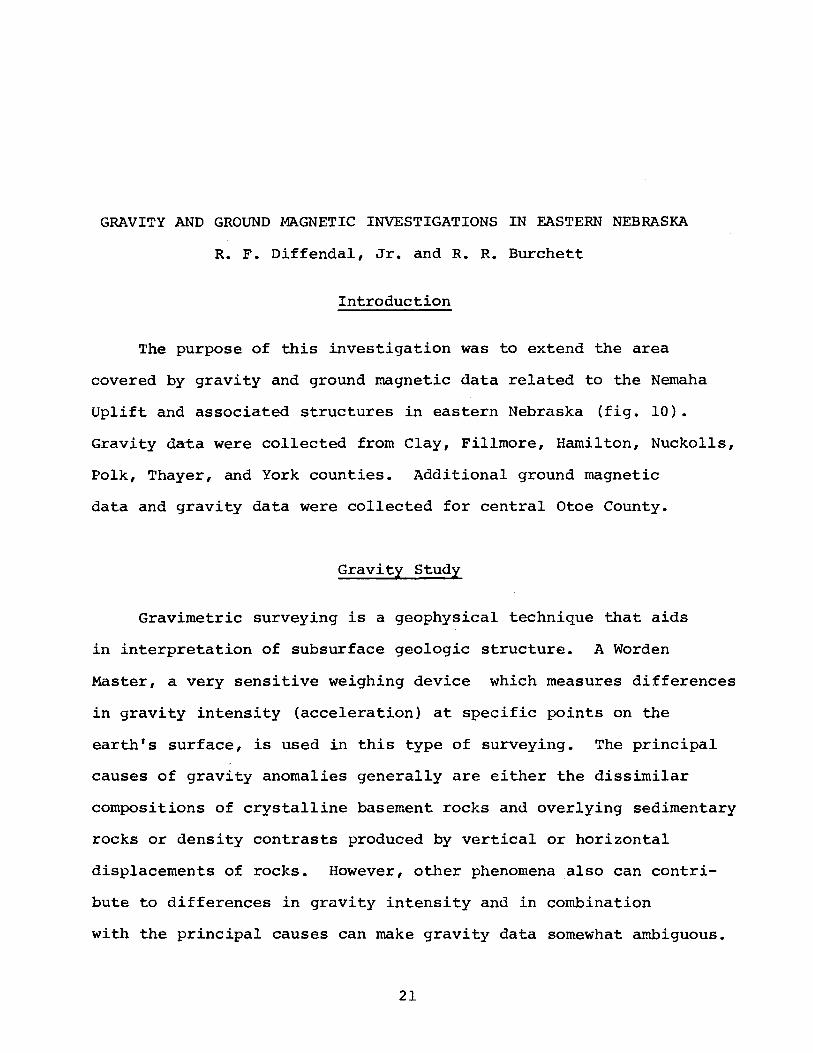
14 Location of Bouguer Gravity Stations in Fillmore County. . . . . . . . . . . . .. . ... 28
15 Location of Bouguer Gravity Station in Hamilton County. . . . . . . . . . . . . . . . . . . . 29
v

Figure Page
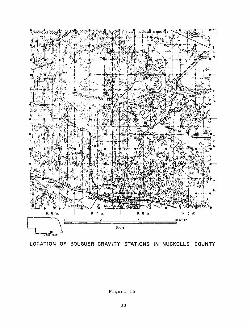
16 Location of Bouguer Gravity Stations in Nuckolls County. · · · · · · · · · · · · · · · · · · · · · 30
17 Location of Bouguer Gravity Stations in Polk County. · · · · · · · · · · · · · · · · · · · 31
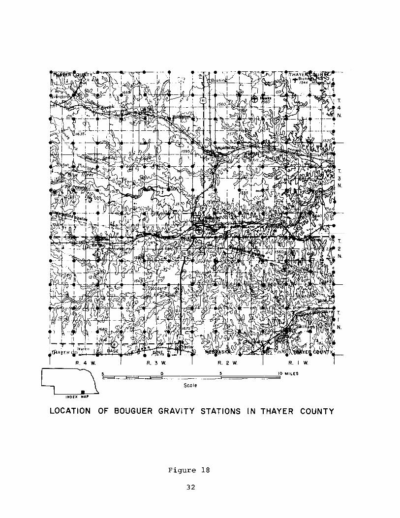
18 Location of Bouguer Gravity Stations in Thayer County. · · · · · · · · · · · · · · · · · · · · · 32
19 Location of Bouguer Gravity Stations in York County. · · · · · · · · · 33
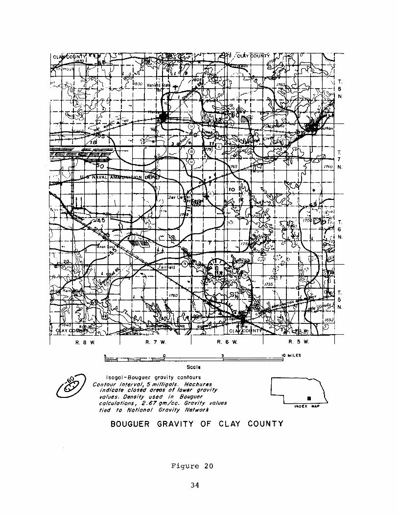
20 Bouguer Gravity of Clay County. · · · · · · · · 34
21 Bouguer Gravity of Fillmore County. · · · · 35
22 Bouguer Gravity of Hamilton County. · · · · 36
23 Bouguer Gravity of Nuckolls County. 37
24 Bouguer Gravity of Polk County. · · · · · · · · 38
25 Bouguer Gravity of Thayer County. · · · · · 39
26 Bouguer Gravity of York County. · · · · · · 40
27 Bouguer Gravity Anomaly Map in Eastern Nebraska 41
28 Total Magnetic Intensity of Northeastern Cass and Eastern Sarpy Counties. · · · · · · · · · 43
29 Index Map of Southeast Nebraska and Northeast Kansas · · · · · · · · · · · · · · · · · · · · · 46
30 40Ar/ 39Ar Age Spectrum Diagram for St-l and st- 2 52
V1

Table
1
2
3
4
LIST OF TABLES
Microearthquakes in Nebraska . . . . . . . . . .
Modal Analyses of Specimens from St-l and St-2 .
Chemical Compositions . . . . . . . .
Age Spectrum Analysis Analytical Data
V11
Page
19
48
50
51


ABSTRACT
This annual report presents and interprets the information
obtained by the Conservation and Survey Division (Nebraska Geological
Survey) during contract year July 1, 1980, to June 30, 1981,
under contract NRC-04-76-3l5 with the U. S. Nuclear Regulatory
Commission. The information pertains to the geology, structure,
tectonics, and seismicity of eastern Nebraska with emphasis on
central Otoe County. Some of the information presented here
results from a combination of studies begun in earlier years but
the greater part results from studies begun during the contract
year.
The scope of the studies is summarized as follows:
1. Rock outcrops in Otoe County were reexamined and reevaluated,
and 22 test holes were drilled to deten,tine the al ti tude of
the upper surface of the Elmont Limestone of Pennsylvanian
age;
2. One new seismograph was installed in eastern Nebraska;
3. Gravity surveys in eastern Nebraska were extended;
4. Ground magnetic surveys in Otoe County were made and
evaluated.
5. Age dating of two Precambrian cores.
Discussion of the results of these studies constitute the
remainder of this report.

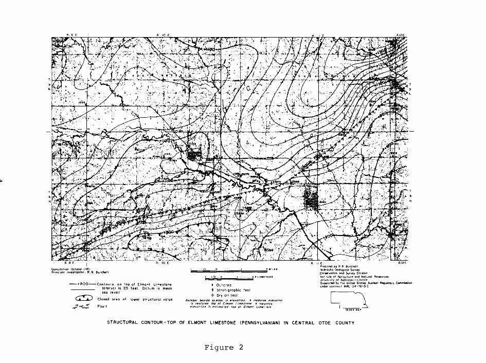
STRUCTURE OF THE ELMONT LIMESTONE IN CENTRAL OTOE COUNTY, NEBRASKA
R. R. Burchett and M. R. Bolitho
Introduction
A specific site area in central Otoe County, Nebraska was
chosen for study in 1980-81 because it overlies the southwestern
extension of the Union Fault (fig. 1). The Union Fault defines
the southern margin of the northeast-southwest trending midconti
nent gravity anomaly. Southward from it the rock strata either
are down thrown or dip steeply into the Forest City Basin.
The primary purposes of this investigation were to acquire,
by drilling test holes, subsurface data needed to correlate
buried strata with strata that crop out and to gain a better
understanding of buried structural features in eastern Nebraska.
The top of the Elmont Limestone, a member of the Emporia Formation
of the Wabaunsee Group (Virgil Series) of the Pennsylvanian
System, was chosen as a datum plane for a structure map because
the Elmont underlies most of the study area at a shallow depth
and is easily identified in rock cuttings obtained by drilling.
All available data on the altitude of this surface in outcrops
and in test holes were used as control points for contour lines
depicting the configuration of the Elrnont's upper surface (fig. 2).
2

w
10 .... ,,'
...... (0
Dlu'L ~ (it
EXPLANATION MINOR FEATURES
(0 RICHFIELD ARCH
® DENTON ARCH
o CRETE FAULT OR FLE XURE
® UNION FAULT
OR FLEXURE
KilT ...
~r.I(I"S
''''.11. rii
OUIIOY
T~ 1-1-~O
J-
PRINCIPAL STRUCTURAL
aliA HM&
.""Aio
CIENTRAL
(~'H:il Study area
FEATURES OF NEBRASKA (Corlson, 1970)
Figure 1
........ ".'IS I , ,
' .......... , ....... .. l I I • • ,
NEMAHA UPLIFT
"'"
T.
N.
'.' ... ,: - .. - - 'i: ,.,' :j!!~...;,. i ,. ", ~:--~:d ~ ~.f::~ • D~ ~~,~_t~. 1" -~ . <·:f.~~ .:~~~_. J: ~~r~ "::'C'T ~~ - fr lf~"~ .
Compilation October 1981 Principal inv •• tigator. R. R. Burchett
-+800-Contours on top of Elmont Limestone Intervol is 25 feet. Datum is mean sea level
~ Closed oreo of lower structurol value
~~o:: Fault
II _~ " .... A ~ r,. /" v"
," In 0 2 KILOMETERS
x Outcrop
(I Sirot i graphic test
"*" Dry oil test NfI",b~r !wsld, sym/)o/ is ,I,yoli"n. It indica/,s ,/,volion
is r,slortd lop of E Imon' L 1""SIOft,. E indIca/,s 'leI/of/on is estimated lop of Elmonl Llm~!."}tI(!
R. II E. Prepared by R,R. Burchett Nebraska Geological Survty Conservation ond SUfvey Division Institute at AI;lriculture and Natural Resources U!liversilv of Nebraska - Lincoln
N.
Supported by the United States Nuclear Regulatory Commission under contract NRC-04-76-315
Ll :1 tNDEIl .... P
STRUCTURAL CONTOUR-TOP OF ELMONT LIMESTONE (PENNSYLVANIAN) IN CENTRAL OTOE COUNTY
Figure 2

Scope of Investigation
Twenty-two shallow rotary test holes were drilled in central
Otoe County (fig. 3) by the Rieschick Drilling Company of Falls
City, Nebraska. The holes averaged about 182 feet (55.6 m) in
depth, and each was logged electrically as well as thru visual
examination of the rock cuttings. Some of the holes penetrated
the Elmont Limestone; others were drilled to an identifiable
horizon whose height above or depth below the Elmont is known,
thus providing an Elroont datum. The holes were drilled in May
and June of 1981 under a cooperative agreement between the
Conservation and Survey Division (I~ebraska Geological Survey)
and the u.S. Nuclear Regulatory Commission (Contract NRC-04-76-315).
A binocular microscope was used for examination of the
cuttings. Logs of the test holes, based on descriptions of the
cuttings, are presented in Appendix A. Figures 4 and 5 show a
composite section of the Lower Penlian and Upper Pennsylvanian
rocks drilled in the study area, together with a composite electric
log of those rocks.
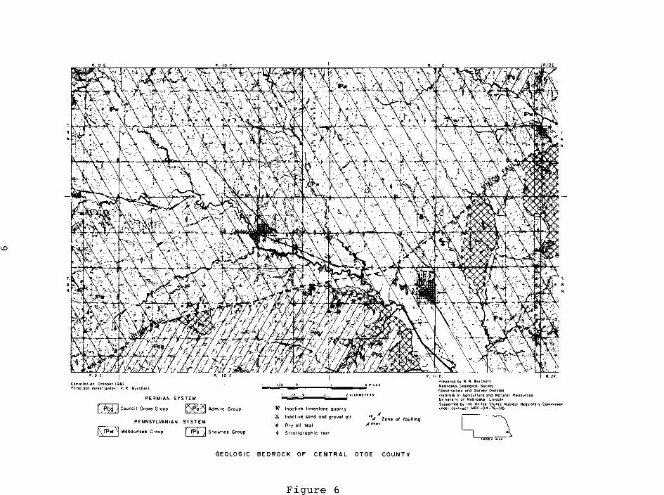
The geologic map illustrated in figure 6 shows the distribu
tion of groups ranging in age from Late Pennsylvanian to Early
Permian. Location of bedrock outcrops, mostly along valley
sides, are shown in solid black. A careful reexamination of
outcrops in the area provided additional data for mapping purposes.
By determining the altitude of many outcrops, the investigators
obtained additional vertical control points for the structure
map.
5

0"1
Compilation Oelober '981 Principal i"vesliqotor; R. R. Burchell ,"
.20-81 Test hole number end locotion
21(ILOMETEIII$~ ~~'/~'~~~~~-----
I DEli. MAP
Prepared by R. R. Burchett Nebraska Geoloqicol Survey Conservation and Survey Division Institute at AqricultUfe ond Naturol ResourCe!> University of Nebrosko- Lincoln
T.
9
N.
T.
N.
~«I''''>d'
Supported by the Unitltd Stoles Nuclear Requlotory Commission under contract NRC-04-76-315
LOCATION OF TEST HOLES DRILLED DURING 1981 IN CENTRAL OTOE COUNTY
Figure 3

Comp".""O<t.Oo<'981 P"." •• """'''Q''.' RRB." •• "
KEY TO LITHOLOGY
Electric log (resistiVity)
KEY TO SYMBOLS
W~RIIrIOIDS ~CORALS
~ BRAC~IOPOos t;:::] OSAG·A
0SR'OlOANS ~GLAUCONIH
•• .,.". 0, R ~ Bo" .... " ..... ~ Bo'''''" " •• ,o"oGoo'09'<O'S.".,
~:':~~~~:f~:~~,:;:~ui:~' .. ~:,~:~!:'OI ~"'U' 00' ~~::~' ;~~, ~:, ~"' .. ~~'.'~~ _s.;~ '_'; ,t' ".' ~.~"'a"K' C"""",, ....
COMPOSITE SECTION OF PERMIAN ROCKS (BIG BLUE SERIES) DRILLED IN CENTRAL OTOE COUNTY
Figure 4
7

0 0 ~ ." 0 (J)
.... '" (J)
'" 0 .... 0 z
0 ."
."
'" Z Z (J)
-< !;;: .. z .. z
'" h:j 0 0
f-" " (J)
<.Q 00 ~ <
H ii '" (1) r= (J)
Ul '" '" '" (J)
0
~ r r
'" 0
z 0
'" z .... '" .. r
0 .... 0
'" 0 0 c: z .... -<
.~~rnl ", c,~ ;;
[!]D~-~ ~ I ~
~8~81~
Ill/I!l inH~i i ~
~ §i
rJ~[]tJ ~ ~
~
,---- PENNSYLVANIAN SYSTEM
<
SOLDIER CRH~
<1
~ <l 1; g ~
".
l<i ~ 6 8
nr
VIRGIL SERIES WABAUNSEE GROUP
lEUOAlE I PILlS8UfH-ROQT WOOD SIDING t FORMATION
11l
~ i!: <l 1; ~
PENNSYLVAN I AN
~
'" ~ ~ '"
Thickness. in leel Tesl hole number
Lilhologic section
Deplh, in leel
-'" ~.& ~'n'
~.&
SYSTEM VIRGIL SERIES
SHAWNEE ----'-'-c:,::.:"'--- ----~ ------ ---WABAUNSEE GROUP ILECO I I II~IU" I i TECUMSEH - DEER CRltl~ I I TDPEU SCRJ.~TON FORMATION
I ~I 0 I~I~ g ~
01; ~I;
1':.1'1 'i','i};', I'i' ,',',1,',',', I I ".'.'.','.'
l~
~
'" i::
~ '"
Thickness, in feet Tesl hole number
Lilhologic section
Deplh, in leel
~~ ~~ ~.8
1.0
Comj)ilalion October 1981 Principal m"utitalor; R. R. Burchett
PERMIAN SYSTEM
~ Council Grove Group ~ Admire Group
PENNSYLVANIAN SYSTEM
~ Wobounsee Group [!D Shownee Group
," ,"
~ Inactive limestone quorry
.x Inactive sand and grovel pit
+ Dry oil tut
~ Stratigraphic test
"' ,( " Zone of fouitin9 ;/dOw"
GEOLOGIC BEDROCK OF CENTRAL OTOE COUNTY
Figure 6
Prepared by R. R. Burchett Nebraska GeolC)9lcol Survey Conservation ond Survey Oi'lision Institute of Aqriculture Qnd Noturol Resources UniversllY of Nebrouo - Lincoln
T.
N.
Supported by the United Sioles Nuclear Requlolory Commission under controct NRC-04-76-315
~
Most upland and lowland areas are mantled by unconsolidated
Quaternary deposits such as loess, till, and alluvium. The maxi
mum aggregate thickness of these deposits is 400 feet (122 m).
Results of Investigation
Interpretations based on drilling results and field observa
tions during this investigation are summarized as follows:
(1) The Union Fault probably is not a single structure, as
previously interpreted. Instead, it is a complex zone of
faults and steep dips affecting rocks as young as Permian
in age.
(2) Pennsylvanian and Permian age rocks are faulted along
the Union Fault. The direction and angle of dip exhibited
by these rocks, on both sides of the Union Fault, differ
markedly within very short distances, thus indicating that
the structural pattern is highly complex. The greatest
dip measured about lsoSE, just east of the area of study,
is in the SW sec. 6, T. 9 N., R. 13 E., in Otoe County
(Burchett, 1980).
(3) Only two faults have actually been observed in outcrops
near the study area, and both are located along the Union
Fault. One is in the Mv NW sec. 21, T. 10 N., R. 14 E.,
Cass County, and was observed by Condra and Reed (1938)
many years ago before quarrying destroyed the outcrop.
Throw along this fault was reported to be 8.8 feet (2.7 m)
in the Deer Creek Formation of Pennsylvanian age, but no
mention was made whether that or any other faults involved
Quaternary deposits. ?he other fault is in the NE SW
10

sec. 6, T. 9 N., R. 13 E., Otoe County. Here the Lecompton
Formation of Pennsylvanian age is displaced about 3 feet
(0.9 m). Overlying Quaternary deposits do not appear to be
faulted.
(4) Displacements along the faults not observable in outcrops
but indicated on figure 2 are interpretive for the following
reasons: Thick glacial deposits mantle the bedrock throughout
most of the study area; outcrops are of small areal extent
and consist of strata so similar that their correlation is
difficult; and the distance between outcrops and test holes
available for interpretation ranges from 0.1 (0.161 km) to
1 mile (1.61 km). The greatest interpreted throw of the
Elmont Limestone on the Union Fault, about 200 feet (61.0 m),
is in the southwestern part of the study area.
(5) The altitude of the top of the Elmont Limestone (fig. 2)
ranges from about 800 feet (243.8 m) above mean sea level
in the southwestern part of the study area to more than
1100 feet (335.3 m) north of the Union Fault.
(6) Faults and/or steep dips in the area probably reflect
faulting and steep dips at depth. Deeper structures are
indicated by contours drawn on the base of the Hertha
Limestone, a formation in the Kansas City Group of the
Missouri Series of the Pennsylvanian System (Burchett, 1978)
and on the surface of Precrunbrian rocks (Carlson, 1967).
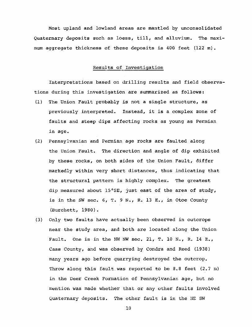
(7) Several deep drill holes have penetrated the Precambrian
age rocks in Cass, Otoe, Lancaster, and adjacent counties
to the south. Locations of these holes and the elevation
of the Precambrian surface are shown in figure 7.
11
f-' I\J
R.SE. R.6E. R.7E. R.8E. r --1 LANCAstER co. 1--~g.!. R.IO E. r-', I '-,
,."'"' ' J; CASS ICO.
R.12 E.
96°
R.13E. R.14E.
---t:"""h. Pla-ttsmo~th'
.. ,..." " II ~ I ~. JYX 41°
T'I II N. \
J ~~.-~----~----~-----+----~------nll--~~r-~~/,
T.I 10 I N.
LI NCOLN I
t) . ~'I" I
r 264 ~J. .~ _____ -_I --...lL~~ ~
II ~I- t-'3'5\
T OTOEfo. ~ 9+24 I -<J.. ,/
T I 3: 1
9-392
.t( I J.. I( g' -495 I V, v-<'" .t( J.. N. ~ J.::996 -75~A628. I -58~ -5941 . ~~;( ~fc
I Y -952 YY I -y- *1 E 1535 ~
I I -685 -< ~ u.::-593 -< , -1915 -670 roy- -<.,. =--~. I -t I 1 ".,~ ... of I § ~! Nob".k, c;t, '~ N'I ~~ I 1 ~~i i . I --- I ,(' I ~.. "'f ' I E-676,,< ~850 -620<> I I J:,.! I 1 1 ('
+·1 11 J 1,( J22.'A...,i;29~1 ..Jc139 ,.1! , O~A..E'"1334! <fI( Yy YI -y -1549 I G:i"V -y I I N. I .t( A E-336 ~~"?' I , -< -y, I.... __ <c._ I' ~ - GAGE CO. T';:-:;=-"T" -- -,'-- JOHNSON CO.. -;-~ 1"9-".: ~ l- ~ ~EMAHA 'CO. :;'Jj T. I I · I'· I ~ ~-""', -( ~. ~ .. E-97~ i I :t t i I ~ -2558i"~
o IOMILt.l:i . ,
o 5 10 KILOMETERS , , . ";i<-< Zone of faulting or steep dip
down
-t Deep drill hole
<> Stratigraphic test
Datum is mean sea level
~850 Precambrian elevation determined by drilling
E-977 Precambrian elevation estimated
II ~ ELEVATION OF PRECAMBRIAN SURFACE
Figure 7

Interpretation of these elevations indicates that faulting
probably occurred in the Precambrian rocks along the Union
Fault.
13

REFERENCES
Burchett, R. R. 1978. Regional tectonics and seismicity of
eastern Nebraska, Annual Report, June 1, 1976--June 1,
1977. Available from National Technical Information
Service, Springfield, VA 22161. (NUREG/CR-0053)
Burchett, R. R. 1980. Regional tectonics and seismicity of
eastern Nebraska, Annual Report, June 1978--May 1979,
p. 10. Available from National Technical Information
Service, Springfield, VA 22161. (NUREG/CR-1328)
Carlson, M. P. 1967. Precambrian well data in Nebraska including
rock type and surface configuration. Nebraska Geological
Survey Bulletin 25. Lincoln, Nebraska: Conservation and
Survey Division, University of Nebraska.
Carlson, M. P. 1970. Distribution and subdivision of Precambrian
and Lower and Middle Paleozoic rocks in the subsurface of
Nebraska. Nebraska Geological Survey Report of Investigations
3. Lincoln, Nebraska: Conservation and Survey Division,
University of Nebraska.
Condra, G. E., and Reed, E. C. 1938. The Redfield anticline of
Nebraska and Iowa. Nebraska Geological Survey Paper 12.
Lincoln, Nebraska: Conservation and Survey Division,
University of Nebraska.
14

EARTHQUAKE HONITORING NETWORK IN NEBRASKA
R. R. Burchett & Russell Smith
The Conservation and Survey Division (Nebraska Geological
Survey) and the Geology Department of the University of Nebraska
Lincoln collaborated in the installation of a portable micro
earthquake station in Nebaska during contract year 1980-81.
This station, near Dwight, was a replacement for the station
near Columbus which developed high background noise.
As of July 1, 1981, a total of seven earthquake monitoring
stations were operating in Nebraska. Locations of these stations
are shown in figure 8. Precise location and other pertinent
information about these stations are given below:
Site designation LCN. Location: E/2 NE NE SE sec. 23, T. 10 N.,
R. 6 E., lat. 40 0 48' 42" N., long. 96 0 42' 07" W.; on
University of Nebraska-Lincoln campus at Lincoln in Lancaster
County, Nebraska. Instrument altitude: 1,165 ft. (355 m)
msl datum. Operation begun September 1, 1977.
Site designation DTN: Location: Center SE Nlv SW sec. 6,
'11.12 N., R. 4 E.; lat. 41 0 01' 18" N., long. 97 0 02' 09" W.;
on James Tesina farm near Dwight, in Seward County, Nebraska.
Instrument altitude: 1,523 ft. (464 m) msl datum. Operation
begun August 25, 1980.
15

'lOut O&wn 'MilliDA" CMr'"
10 0 10 to 10 .0 .I~I' l !
I". JAHA
10 0 10 10 10 .K'L.O.'T'., L I I ! t !
lOx ."TTI
•• A.f r"OOil" IfMOUI liLA'.' Icoui> MO •• ILL .A"D •
~ r~ I···,.-nso- ICOUM rliITU
• '.I'Ll ==--f CN Y ••
IIITM I LIt'COL. I'MUoioa. JNOWARO
OlurL , f-' 0'1 r"·IN' -------, 10'.So. l''''''LO (MALL
• Beatrice (HMN) CMTIl M - -_.. I_a,..~" I,;-MIL" lau".YlADA-.1 (ccn I flLL.oll I 'ALT. Seismometer locat ion ond I Medicine_ Cree,k Dam (MKN) station abbreviation
T'unLTiiTwulTu (_ucaocc 0""0" N'TCNCOCI . ~ .... ....... ". I p""" •• IMUCU • I Indianola (INN)
LOCA TION OF EARTHQUAKE MONITORING STATIONS IN NEBRASKA AS OF JULY I) 1980
Figure 8

Site designation JHN. Location: NW corner SW NE sec. 36,
T. 6 N., R. 12 E.; lat. 40 0 26' 49" N., long. 96 0 01'
03" W.; on Douglas Boellstorff farm near Johnson in Nemaha
County, Nebraska. Instrument altitude: 1,080 ft. (329 m)
ms1 datum. Operation begun December 5, 197t:l.
Site designation HMN. Location. NW SW SE NW sec. 26, T. 4 N.,
R. 5 E.; lat. 40 0 17' 11" N., long. 96 0 50' 08" W.; on
Homestead National Monument of America Site near Beatrice
in Gage County, Nebraska. Instrument altitude: 1,207 ft.
(368 m) msl datum. Operation begun June 20, 1979.
Site designation SGN. Location: SE NW NE SE sec. 30, T. 13 N.,
R. 11 E.; lat. 41 0 3' 57" N., long. 96 0 13' 7" W.; on
Leroy Nielson farm near Springfield in Sarpy County,
Nebraska. Instrument altitude: 1,140 ft. (348 m) msl
datum. Operation begun June 20, 1980.
Site designation MKN. Location: NW SE NW sec. 25, T. 5 N.,
R. 26 W.; lat. 40 0 22.44' N., 100 0 13.50' W.; near Medicine
Creek Dam in Frontier County, nebraska. Instrument altitude
2,395 ft. (730 m) msl datum. Operation begun March 11, 1979.
Site designation INN. Location. NW SW SW sec. 29, T. 3 N.,
R. 27 W.; lat. 40 0 11.55' N., 100 0 24.01' W.; near Indianola
in Red Willow County, Nebraska. Instrument altitude 2,500
ft. (762 m) ms1 datum. Operation begun September 15, 1979.
All stations are equipped with Geotech Portacorders model
RV-320 and Geotech model S-13 seismometers except the I~m and
~~N stations are equipped with Geotech model S-500 seismometers
and INN with a GSC-20D seismometer.
17

Each station is operated by a volunteer who agreed to (1)
permit installation of a seismometer vault on his property, (2)
provide housing for the amplifier-filter-recorder-clock system
and the WWV time-signal radio receiver, and (3) change the
seismograph recorder charts, replenish the ink supply, and reset
the clock whenever necessary on a 365-day-per-year basis. All
seismographic records with the exception of Medicine Creek and
Indianola are sent to the University of Nebraska-Lincoln for
preliminary analysis and then are forwarded to the Kansas Survey
for more detailed analysis. The seismographic records from
Medicine Creek and Indianola are sent directly to the Kansas
Geological Survey.
The Nebraska seismometers, together with seismometers in
the adjacent part of Kansas, provide continuous coverage of
seismic activity along the buried Nemaha Ridge.
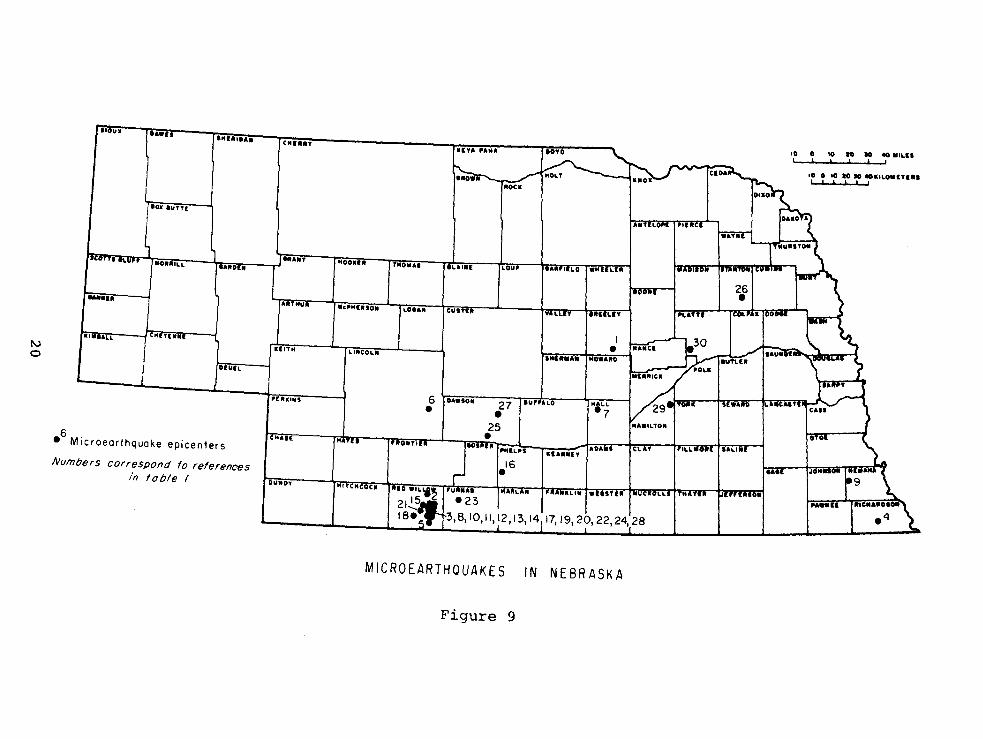
Thirty microearthquakes centering in Nebraska were recorded
between August 1977 and July 1981. Table 1 and figure 9 show
the location of these microearthquakes.
18

TABLE 1
MICROEARTHQUAKES IN NEBRASKA
Latitude Longitude Depth2 Magnitude 3 Map Date Origin Time Degrees Degrees
Ref. (UTC) 1 North West (Km)
1 1977 Aug 18 10:34:25.21 41:24.90 98:28.07 5.00 2.5 2 1977 Dec 1 13:04:34.20 40:18.53 100:22.00 5.00 2.3 3 1977 Dec 1 13:22:38.57 40:12.52 100:17.87 5.00 2.4 4 1978 Jan 13 20:15:33.39 40:05.58 95:42.00 5.00 1.7 5 1978 Feb 3 0:25:47.62 40:01.92 100:20.00 5.00 2.4 6 1978 Sep 14 8:06:18.59 40:53.76 100:22.00 5.00 2.2 7 1979 Apr 8 22:46:10.41 40:58.12 98:33.83 0.67 2.4 8 1979 Jun 6 16:16:21.91 40:08.61 100:20.88 1. 00 2.5 9 1979 Jun 12 11: 13: 11. 88 40:24.33 96:03.26 2.07 1.8
10 1979 Ju1 16 0:03:48.18 40:10.07 100:17.22 5.00 2.7 11 1979 Ju1 16 1:34:20.32 40:11.59 100:20.70 5.00 2.5 12 1979 Ju1 16 5:27.01.42 40:11.45 100:20.00 9.08 1.3 13 1979 Ju1 16 6:08:09.89 40:11.32 100:20.73 11. 09 1.5 14 1979 Ju1 16 7:05:56.02 40:12.00 100:19.90 7.08 1.1 15 1979 Ju1 24 4:16:46.09 40:12.47 100:26.00 0.88 2.2 16 1979 Ju1 24 8:04:46.26 40:27.94 99:37.38 0.87 1.9 17 1979 Aug 2 4:16:21.66 40:10.34 100: 21. 44 0.84 2.5 18 1979 Aug 13 11:09:47.65 40:06.80 100:30.10 1. 50 1.7 19 1979 Aug 14 23:59:31.37 40:10.39 100:20.58 1. 76 1.5 20 1979 Aug 15 6:45:53.87 40:08.68 100:20.34 1. 51 1.5 21 1979 Aug 15 16:07:07.14 40:08.49 100:26.43 1. 23 1.3 22 1979 Aug 31 8:00:11.70 40:08.31 100:20.22 1. 53 2.2 23 1979 Nov 19 4:58:43.40 40:14.86 100:02.77 13.57 1.5 24 1979 Nov 29 22:02:31.21 40:09.80 100: 21. 64 3.15 1.9 25 1980 Apr 26 14:21:48.50 40:43.99 99:43.91 5.00 2.3 26 1980 Aug 13 5:50:11.83 41:53.59 97:06.01 9.90 2.1 27 1981 Mar 13 12:42:16.68 40:53.44 99:41.67 5.00 2.4 28 1981 Mar 20 5:09:48.17 40:10.31 100:19.60 1. 75 1.4 29 1981 Apr 20 18:18:15.28 41:01.02 97:49.49 20.80 2.4 30 1981 Jun 26 18:55:02.07 41:31.75 97:39.06 5.00 2.8
1 (UTC) Coordinated Universal Time.--Subtract 6 hours for Central Standard 2 Time. 3Depth calculated in kilometers or fixed at 5.00 km. Duration magnitude calculated from equation derived by Oklahoma Geological
Observatory.
19
tlOIIi O&_u INI •• DAii
CMI ... U"-'ANA
'0 0 '0 10 10 • MILII l " ,
'0 0 .0 aD 10 •• 'LOMnUI L I I I I I
ROCK
.Oll' aUTTE
•• 'lIff Hoo'-f" rNOMAI ('\.A.IIE ru
' IIAN"no 'WNlhU
-O •• 'Ll .UDIIl
~ I A .. , NUN • .,'H,.SO .. LOt, .. tUITi
I (.M'ALL ICMUUII.
• I\J KIITH L.UICOL ..
NOWANO 0 t DIUIL
6 [O'.so" rU"ALO I MALL -1 /",,""0 .. I "WAitO I\.uue 'UO'NS
• ·7
.6 M" " I ,.\.\.MOII 11A~.jj
MAl
~s I.UN.I~iOA'" - I CLn-Icroeorthquoke epicenters
16 Numbers correspond fo referenoes • in table I OUND., HI CHCOCK ID Will" ...
NA"LAN l'UiiIlLil.r"STU ,IIUUiA'IU jffJ'"HfOlI 3,8,10, 11,12,13,14,17,19,20,22,24,28
MICROEARTHQUAKES IN NEBRASKA
Figure 9
GRAVITY AND GROUND MAGNETIC INVESTIGATIONS IN EASTERN NEBRASKA
R. F. Diffendal, Jr. and R. R. Burchett
Introduction
The purpose of this investigation was to extend the area
covered by gravity and ground magnetic data related to the Nemaha
Uplift and associated structures in eastern Nebraska (fig. 10).
Gravity data were collected from Clay, Fillmore, Hamilton, Nuckolls,
Polk, Thayer, and York counties. Additional ground magnetic
data and gravity data were collected for central Otoe County.
Gravity Study
Gravimetric surveying is a geophysical technique that aids
in interpretation of subsurface geologic structure. A Worden
Master, a very sensitive weighing device which measures differences
in gravity intensity (acceleration) at specific points on the
earth's surface, is used in this type of surveying. The principal
causes of gravity anomalies generally are either the dissimilar
compositions of crystalline basement rocks and overlying sedimentary
rocks or density contrasts produced by vertical or horizontal
displacements of rocks. However, other phenomena also can contri
bute to differences in gravity intensity and in combination
with the principal causes can make gravity data somewhat ambiguous.
21

N [\)
[l] Gravity study completed
before July I, 1980
~ Gravity study completed
1980-81
LOCATIONS OF GRAVITY AND MAGNETIC
em Ground magnetics study
completed before July I, 1980
STUDIES IN
Figure 10
10 0 10 10 JO .. MILII I I !
to 0 10 10 JO .KILOMIT'., I I 1 J • ,
-Ground magnetics study completed 1980-81
EASTERN NEBRASKA

All gravity base stations in the Nebraska Gravity Network
are tied to the National Gravity Network base station located at
the Lincoln Municipal Airport. Gravity stations established
during this study were located at section corners and in some
cases half-mile section lines (fig. 11). Land-surface altitudes
at most stations could be determined directly from 7.5-minute
topographic quadrangles. For other stations, land-surface alti
tudes were established from topographic contours and are accurate
within +2 feet.
Field gravity data were corrected for latitude, meter drift
and elevation; earth tides were not considered. The maximum
error in station altitudes was enough to produce- variations of
+0.2 milligal. Slight inaccuracies in station locations--none
greater than 0.1 minute of latitude--could have produced errors
of no more than +0.08 milligal. A +0.02 milligal error was
possible from either tidal or instrumental sources. Therefore,
the maximum possible was +0.3 milligal but generally was much
less because some errors were compensatory.
Bouguer values were calculated from assumed computational
density values of 2.5, 2.6, and 2.67 gm/cm3 • The average density
value of 2.69 gm/cm3 obtained by Muehlberger and others (1964)
for two samples of Precambrian crystalline rocks indicated that
2.67 gm/cm3 would be the most realistic Bouguer computational
density value. These three densities were used to compute the
efforts of observed gravity versus theoretical gravity for anomaly
interpretation.
In central Otoe County 253 gravity stations, in addition
to those previously established, were used to produce a
23

LOCATION OF BOUGUER GRAVITY STATIONS
IN EASTERN NEBRASKA
!I--, -+--+-~++-.-;; I' " !. , .' -~, \ ! I ........ ·~r1n
r-- --,- --r- .-f--- ! r h .... "If' 2. l ' :0 A K 0 A}
!--+-+_+-t-+-t---+-+----i-- r-- - -t-+----t-t-_+_--Ir-----t-'...
i" R C E ! L;- -r- --L'~A-N+T-E+-L+ i0+-P-E~~I--H-+--+-•. + .. i .. -.~-.-+--r---t---+:I ;
Ii--' ~--'r-"+''''+' ---tf-_+- _ H .. --L _1 ____ _ i~ ~ f-U_R+--S f-T _0 '+1'\-\.,
! r' '~''''Q I _ l-----~ ...
~ r' 0 ISO N ....... I' C I" M I jtc G! '1 .--~ ~~~~~~~~~~~~~~-t__t-1__r-t__t_?
!S T ~ N 0 i ,.._" ..... T \
1----+-+-+4J.-~-+--+-+ •• -.. -.... +--+-+-~-+-~~-~-r-+--t--l I N E 21 ~.'-.' lJ' • 10 0
' ..... " •••• Ot_",., ~""< .•• , ..... " ...... " e •• , •• ~
o '0 lO )O.'"O .. (TUS -~~~-~
Figure 11
24
EXPLANATION
CONTROL POINT
~oure",,~ I("""ity data: rJnpublh!>cd d"to. r ..... the ,'onlcrv,Uon .,.,d ~;ur""1 DI,,'-I n rllu .
.... _ ..... ~ • .,< .. ~ •• ,.' C''''" •.• , _ .... G •• • ... , .. ,,· •• ,
< ..... ""' .. ' .n. S ..... D,,'._ ,,,'d.,, .. '''''''''''' ••• ~ ...... ....... ,., .. "" .. ,~t,.,_. __ '"' ... "-.... 0 .. • .. u.,,., \"", ~ .. _ ..... "' .. ,C.~~, ..... ,"'0' <0""',' ~"C -0.- 'l' "~

hand-contoured Bouguer gravity map (fig. 12). In addition about
980 gravity stations were occupied in Clay (fig. 13), Fillmore
(fig. 14), Hamilton (fig. 15). Nuckolls (fig. 16), Polk, (fig.
17), Thayer (fig. 18), and York (fig. 19). Data collected at
these stations were used to produce Bouguer gravity maps for
each of the counties (figs. 20, 21, 22, 23, 24, 25, & 26).
These data were also integrated with previously collected data
to generate a comprehensive regional Bouguer gravity map of
eastern Nebraska (fig. 27).
Ground Magnetic Study
The instrument used in the ground magnetic study was a
Geometric~826 Proton Magnetometer. This instrument measures
the total magnetic field with an accuracy of +1 gamma. Magnetic
anomalies are produced by differences in the degree of rock
magnetization (polarization). Although, to a large extent,
magnetic intensity is related directly to the percentage of the
mineral magnetite in rocks, depth to the magnetic source rocks
is another variable that affects the measurements.
During field operations about 300 magnetic stations were
established at 0.5- and 1.0- mile spacings in central Otoe County.
Sites selected as magnetic stations were well-removed from artifi
cial magnetic sources such as fences, power lines, and pipelines.
Corrections for diurnal magnetic drift were made by making observa
tions at a base station at 3-hour intervals and then using those
observations to correct, by linear interpolation, the readings
made at field stations between base stations. No corrections
25

N 0'1
R to E
COmO,lol,on Oelob"" 1981 P"nCIDol Investigator' R R Burchett
.-l9' Control point with milligol value
--30- Isegal-Bouguer gravity contours (contour intervol I mliligol)
Density used in Bouguer calCulations 2.67 gm/cc
Gravity "olues tied to Notional Gravity NetworK
"'ZW~_"""iiiOiiiiOi .. 2 ~ILOMET£RS
~= BOUGUER GRAVITY OF CENTRAL OTOE COUNTY
Figure 12
R II E
Prepared Nebraska
Regulatory CommiSSIon

T. 8 N.
T. *""''''*''---1 7
N.
T. ~~--~4-~~~~~5
Ll :) 'EE""3::::::::3C::::EE""3:=r:::::JE+3:=;'iO=====S=C=O=1 e====='EI :=::::::::=:=::::::::=:====:3IF MILES
INDEX MAP
LOCATION OF BOUGUER GRAVITY STATIONS IN CLAY COUNTY
Figure 13
27
N.
R. 4 W. R. 3 W.
~ :\~H_ Scole
===j~======3If MILEI
INDEX MAP
LOCATION OF BOUGUER GRAVITY STATIONS IN FILLMORE COUNTY
Figure 14
28

LOCATION OF BOUGUER GRAVITY STATIONS IN HAMILTON
• Scale Flgure 15
29
R. 5 W .
t
·Itll~ . . zl ! ::>;
·G· u, z ~
...J'
\I
N.
j 9 , N.
LOCATION OF BOUGUER GRAVITY STATIONS IN NUCKOLLS COUNTY
Figure 16
30

\- R. 3 W t ('.
~ ~ t--,~=C==~~==3C==~~=i0======s=c=a=le======~?E:==============3I~ MILES
INDEX MAP
LOCATION OF BOUGUER GRAVITY STATIONS IN POLK COUNTY
Figure 17
31
T. 15 N.
T.
-~ i .l68 ~11~~-4 ~ ~·I·· ,,..{,' j "~rl>lI
j,rllYfH ~) ............ ...;I.(IilII-+~~~1'""1>'
R.4 W. R. 3 W. R. 2 W.
Ir----~ 'EEF3:::::3:::=::J:F""""""3===r::=::::EF=3===:30==============:=:::J::~ ===============~===:ll? MILES
~ ~\ Scole
INDEX MAP
LOCATION OF BOUGUER GRAVITY STATIONS IN THAYER COUNTY
Figure 18
32

Ll ~'E=::3:::::::e===:C=:::::EaO=====S=C=OI=e =====!lE;;;;;;;==============aIO
MI LU
INDEX MAP
LOCATION OF BOUGUER GRAVITY STAT IONS IN YORK COUNTY
Figure 19
33
b E=3:::::::lF3=3:=::EE+3=3:°=======::::::'EI ==========3'~ "ilLES
Scole
I 50gol- Bouguer gravity contours Contour interval, 5 mil/igals. Hachures
indicate closed areas of lower gravity values. Density used in Bouguer calculations, 2.67 gm/cc. Gravity values tied to Notional Gravity Network
~ :) INDEX MAP
BOUGUER GRAVITY OF CLAY COUNTY
Figure 20
34

R. :3 W. R. I W.
'EE3==_.3: __ =_:_= EE3:=C:::EE3=Ot.=. ======='1:1 ======3'° MILEI Scole
Isogal- Bouguer gravity contours Contour interval, 5 milligals. Hachures
indicate closed areas 01 lower grovity values. Oensity used in Bouguer colculotions, 2.67 gm/cc. Gravity values tied to National Gravity Network
ll~:) INDEX MAP
BOUGUER GRAVITY OF FILLMORE COUNTY
Figure 21
35
t
N.

BOUGUER GRAVITY OF HAMILTON COUNTY
Isogol- Bouguer gravity contours Contour interval, 5 milligals. Hacflures
indicate closed areas of lower gravity values. Density used in Bouguer calculations, 2. 67gm/cc. Gravity values tied to National Gravity Network
R. 8 W. R,7 W.
Scole
Figure 22
36
R.6 W. R,5 W.

Scale
Isogal-Bouguer gravity contours Contour interval, 5 milligals. Hachures
indicate closed areas of lower gravity values. Density used in Bouguer calculations, 2.6Tgm/cc. Gravity values tied fo National Gravity Network
Ll :\ INDEX MAP
BOUGUER GRAVITY OF NUCKOLLS COUNTY
Figure 23
37

R. 4 W. R. 3 W. R. 2 W. R.IW.
5Ee=-3==~==E~==3C==~~===0t=================5EI================~I~. MILES Scole
Isogal-Bouguer gravity contours Contour interval, 5 milligals. Hachures
indicate closed areas of lower gravity values. Density used in Bouguer calculations, 2.67gm/cc. Gravity values tied to Notional Gravity Network
BOUGUER GRAVITY OF POLK COUNTY
Figure 24
38
T. 16 N.
T. 15 N.
T. 14
N.
T. 13 N.

Scale
Isogal-Bouguer gravity contours Contour interval, 5 milligals. Hachures
indicate closed areas of lower gravity values. Density used in Bouguer calculations, 2.67gm/cc. Gravity values tied to Notional Gravity Network
Ll :\ INDEX IIAP
BOUGUER GRAVITY OF THAYER COUNTY
Figure 25
39

Scole
Isogal - Bouguer gravity contours Contour interval, 5 milligals. Hacllures
indicate closed areas of lower gravity values. Density used in Bouguer calccllalians, 2.67 gm /cc. Gravity values tied to National Gravity Network
BOUGUER GRAVITY OF YORK COUNTY Figure 26
40
INDEX MAP

c" ..... '.· .• nO" .... ".' P,."".p.' ..... ", .... ~ R ,."no"
J '0 lo lO",O"IH"' '------->.------'---~~, ,
Figure 27
41
BOUGUER GRAVITY ANOMALY MAP
~ EASTERN NEBRASKA
o
EXPLANATION
------20_
CONTOUR INTERVAL:! MILLIGALS
HIICHURED TO INDICATE CLOSED AREAS OF LOWER GRAVITY
• EARTHQUAKE EPICENTER
50ucceof,.evltydet.: IInpubll.h"dd.'.fr< .... h@ Con.~rv.tlon end 5urv~Y DtYI~I"n fll"s.
SOU"~M of Utrth<i"~"~ D~t.: Doh.-k.l, .J~rry. 1910, f .. rthqu~h. "I 'h~ subl~ lnt~rlor, .. HI> ~.ptl.-
.h <>" th~ 1I1d,,,ntln .. nt: Unh. lI .. br ... h dl __ ~T-' .. tlonf",Ph.ll.d .. I' ........ 1. 169p .... 2 l11p.,22pl ... (All .. pl, .. "' .. ,d", ..... , .. p. fur th .. 1963 ... rtllqu~k ... ,1, .. no", .. bout J7 .!l". _ .. , or " .. br ........ CI.y) Zoll_a. J.~., 1974, hl_ld,y "r 'h~ 5 ........ "r Okl.h._. hR.", .. ndll.,braBk.,.nd .. dj"' .. n ........ "'"' ... "url .. ndT ... u. I .... 1961 to 1974, Bl .. ,kr".s •• t1"n. R" ... r.Cnunty.Okl ... · Unpubll"htodr"po't'D SMon",,' IIlh,m, In,., .ond BI~,k _114 V.,Ucll. lOT 'ubll< S~r"I,'~ C".,._ny "I Okla",... (lplceniH data IUT 1963 urthquak~ ab",,' I) .I!,,~ vut of JI"bnak. CI.y).
INOEx MAP
o
P'IO ...... R ~ e.".", ". _.f 0." ..... '." ~ ....... Goo,.",., ~ .... , < ...... "."" ••• $," .. 0 .... _ ",,,"., •• , A •• ~." ••• .,. ~.'"''' _ ... ,,, ..
~""""" of ~''''''.-''.<O'' ~:::":::,'.~~, u::; ~~~'~',::'~ .0,",., .. , c_." ... "
were made for latitude. The final magnetic intensity data were
contoured by hand (fig. 28) and show very clearly the southern
edge of the midcontinent anomaly.
42

"'" w
96~ 22' 30'
R 9 E
Compliollon Oc'aber 1981 PrinCipal InyeSIHlotor" R R
R 10 E
,,-IIII/IA'/il ~ 77 /... __ 7/:7:JHI£~ 40°45'00"
.'''''.'' • "498 ."~O'
';""'""1: ~ ' " l_ - - r' • 'H' •
.,64 96
.'HU ,··~·c • n., • .,,472 .~.' •
". .'i."
-p~'''~=-. "-. -------
, ~~.;f' '-"
I -I
.,,,,a ."",n, ."'"
."'Il , ... n. R II E- IIR
"-""00" ..... , 96°07"50
PreparedbyR.R Burehelt NtbrOSkO Geoioq,eaISu'vey Conser.al,on and Survey D,.,sloo losto/ute of Agriculture and Naturol ReSOurces Unl"er501~ of Nebroska - L Incol~
-~o042'3rj"
__ 40°37',0'
" E
."'" Control pOint with magnetic volue Supported by the United SICltes NuClear Regulatory Commls5'0n under conlroc! NRC-04-76-315
#J Magnetic contours showing the total magnetic
field Intensity of the earth In gammas Hochured to Indicate closed oreos of lower magnetic intenSities. Contour intervals 50 and 100 gammas
Dolo were collected With a ground proton magnetometer
C) TOTAL MAGNETIC INTENSITY OF CENTRAL OTOE COUNTY
Figure 28

References
Mueh1berger, W. R., Denison, R. E., and Lidiak, E. G. 1964.
Buried basements rocks of tile United States of America
and Canada: Final Report, Appendix to vol. II, contract
AF49(638)-1115/ARPA Order No. 180-62. Univ. Texas, Austin.
44

SOME PRECAMBRIAN GABBROIC ROCKS FROM SOUTHEAST NEBRASKA
S. B. Treves
Introduction
Our papers on the Elk Creek carbonatite of southeast Nebraska (1972, 1972b,
1975) produced a flurry of leasing, geophysical surveys and, finally, drilling
of the Elk Creek anomaly and some smaller, nearby anomalies. Recently two cores
from boreholes that were drilled to basement at the site of the nearby Steinhauer
anomaly were released to the Conservation and Survey Division for reference pur
poses and study. These cores are described in the sections that follow.
Location
The cores are designated Steinhauer 1 and 2, and are referred to as St- 1
and St- 2 in the rest of the text. St- 1 was drilled (fig. 29) at the center of
the north boundary line of the NW 1/4 NE 1/4 NW 1/4 Sec. 19 T.3N. R.llE. St- 2
was drilled at the center of the south boundary line of the SW 1/4 SE 1/4 SW 1/4
Sec. 14 T.3N. R.12E.
Core Description
Analysis of the core of St- 1 shows that basement rocks were encountered at
a depth of 800.5 feet and that drilling was continued to a depth of 994 feet,
producing 194 feet of core. Analysis of the core from St- 2 shows that basement
rocks were encountered at a depth of 971 feet. Additional drilling to a depth
of 1072 feet produced 101 feet of core. The contact of the basement rocks with
the overlying, younger sedimentary rocks is sharp and nonconformable. It is
clearly not an intrusive contact, as fragments of the older rock occur as clasts
in the basal unit of the overlying sedimentary unit.
The upper portions of both cores are deeply weathered and stained by iron
oxides. The St- 1 core is weathered to a depth of 67 feet; St- 2 core is only
45

: ~\G~
\ #'~/ ~-<" G/
o~~ ~~_c i
\ IOWA ,"---- ----\ MISSOURI
Johnson Co. J '" Pawnee Co. " \
___ NEBRASKA _ _ __ #-1---+ .J ~ ',,-
KANSAS '« STEINHAUE~
i~ ANOMA\Y
Z:J '< ,
INDEX MAP OF
'- ...
I I I
I I I I
Southeast Nebraska and Northeast Kansas 50 Miles
Figure 29 46

weathered to a depth of 5 feet. The rocks of both cores are extensively jointed
and cut by veins of secondary calcite and quartz. The orientation of the joints
ranges from horizontal to vertical, with most being inclined at angles that range
from 30° to 60°. Slickensides are common. The rocks immediately adjacent to the
veins and most of the joints are altered, sometimes extensively.
Below the weathered zone the rocks are strikingly fresh and unaltered and
are black and dark grey. Hand specimens show abundant plagioclase and lesser
amounts of pyroxene, olivine, and opaque minerals. The average grain size
ranges from about 2 mm to about 10 mm. Specimens from both holes are identical
in hand specimens.
Thin-section analysis of unaltered specimens of core indicate the rocks are
gabbroic and that they consist primarily of olivine, plagioclase, pyroxene,
opaque minerals, biotite and traces of apatite and alkali feldspar. The olivine
is magnesium-rich and is generally about Foso. Locally, it is altered to ser
pentine. The plagioclase is generally sodic labradorite. It is complexly twinned
and generally unaltered. In plagioclase-rich rocks the fabric shown by the plagio
clase suggests that it may be a cumulate phase. Some plagioclase shows slight
alteration to sericite. The pyroxenes consist of orthopyroxene and clinopyroxene.
The orthopyroxenes are inverted pigeonites and contain lamellae of augite that are
parallel to the (001) of the original pigeonite. The clinopyroxene is augite,
which contains exsolved blebs of pigeonite. Orthopyroxenes are much more abundant
than clinopyroxenes in these rocks. The opaque minerals are primarily ilmenite,
but some sulphides are present. In many sections the ilmenite and the mafic
minerals are mantled with overgrowths of biotite. Apatite occurs as prismatic,
interstitial crystals or as inclusions in the plagioclase. Alkali feldspar occurs
in the interstices between plagioclase grains.
Modal analyses of the gabbroic rocks are presented in table 2. The analyses
show that the upper reaches of St- 1 consist primarily of anorthositic gabbro,
47

-Ie Q) III to
Q) r- III s... Q) C U r- Q) Q) to C Q) 0 Q)tO +-> +> ..... 0..
.r- X :;:,s... .r- r- III > 0 en CJQ) +-> +-> to\:;)
s... to tOC 0 to ~ r-r- >. r- 0.. • ..- 0.. r-Q) 0 0- 0- O~ CO ex: ex:L.L.
Elevation
St-1
847 9 6 75(57) 5 3 Tr Tr 839.8 5 6 74(65) 11 2 Tr Tr 842 9 7 75(52) 7 2 Tr Tr 944.5 7 23 57(56) 11 2 Tr Tr 989.5 11 28 52(57) 7 1 Tr Tr 994.5-r 4 21 66(55) 7 1 Tr Tr
St-2
974 36 13 32(58) 18 Tr Tr Tr 976 39 7 35(50) 16 2 Tr Tr 978 33 10 40(35) 16 1 Tr Tr
1000 37 5 35(58) 22 3 Tr Tr 1032.5 38 5 33(58) 20 3 Tr Tr 1037 38 5 39(60) 16 2 Tr Tr 1045 45 4 25(55) 17 2 Tr Tr 1051 18 5 39(55) 17 2 Tr Tr 1060 43 4 34(62) 17 1 Tr Tr 1067.5t 31 20 29(62) 18 2 Tr Tr 1070.5 30 13 31(50) 22 3 Tr Tr
tChemical analysis
*Figure in brackets is anorthite content
Table 2. Modal Analyses of Specimens from St-l and St-2.
48

whereas the lower reaches consist of olivine gabbro. The upper and lower reaches
of St- 2, in contrast, consist of ilmenite-rich olivine gabbros, whereas the middle
reaches consist of troctolitic, ilmenite-rich gabbros. The cores seem to exhibit
a coarse lithologic layering. It does not seem possible to correlate units between
the holes.
Near the bottom of both holes the core shows several thin, horizontal layers
of grey carbonate. Thickness ranges from a few centimeters to about 10 centimeters.
These units consist primarily of calcite, phlogophite, apatite(?) and opaque
minerals and may be carbonatites. Further work will be necessary before a final
determination is possible.
Two chemical analyses of fresh specimens of the core were made. The results
are presented in table 3. It is readily apparent that both rocks are abnormally
rich in ilmenite. If allowances are made for this feature, the rocks are not too
much unlike Nockolds' average gabbro. Analysis three is of a basalt obtained
from a borehole, Radenslaben No.1, drilled on the midcontinent gravity high near
Omaha, Nebraska. More chemical analyses will be required to completely charac
terize these rocks.
Two 39A/40Ar dates (Dalrymple and Lanphere, 1971) were determined on plagioclase
separates from St -1 and St ~2 by J. Sutter. The pertinent analytical data and
39Ar/40Ar age spectrum diagrams are presented in table 4 and figure 30. Sutter
reports that both spectra are indicative of the loss of radiogenic 40Ar since
crystallization of the gabbros. Thus, none of the ages indicated by the diagram
is the time of crystallization of the gabbros. The spectra further indicate that
the gabbros are older than the oldest age measured, which was 1.18 b.y. on the
fuse fraction of St- 1 plagioclase. Sutter suggests that both specimens are
likely to be the same age and that the age is probably not much in excess of 1.2
b.y., which makes these rocks Keweenawan in age (Goldich et ~., 1960).
49

(1)
Si02 49.60
Ti02 5.37
A1 203 15.00
Fe203 14.40*
FeO
MnO 0.14
MgO 3.77
CaO 5.99
Na20 2.36
K20 0.86
P20S 0.05
H2O+
*total iron tcomposite sample
1. St-1; 994.5 ft. 2. St-2; 1067.5 ft.
(2) (3)t (4)
34.30 48.50 50.83
12.50 1.48 2.03
8.52 15.80 14.07
35.00* 2.99 2.88
8.74 9.00
0.22 0.19 0.18
5.14 7.44 6.34
2.98 10.20 10.42
1.04 2.37 2.23
0.57 0.34 0.82
0.05 0.10 0.23
1. 52 0.91
3. Radenslaben No.1. C SW 1/4 SE 1/4 NW 1/4 Sec. 28 T13N R8E 4. Average tholeiitic basalt (Nockolds. 1954) 5. Average gabbro (Nocko1ds. 1954)
Table 3. Chemical Compositions.
50
(5)
48.36
1. 32
16.84
2.55
7.92
0.18
8.06
11 .07
2.26
0.56
0.24
0.64
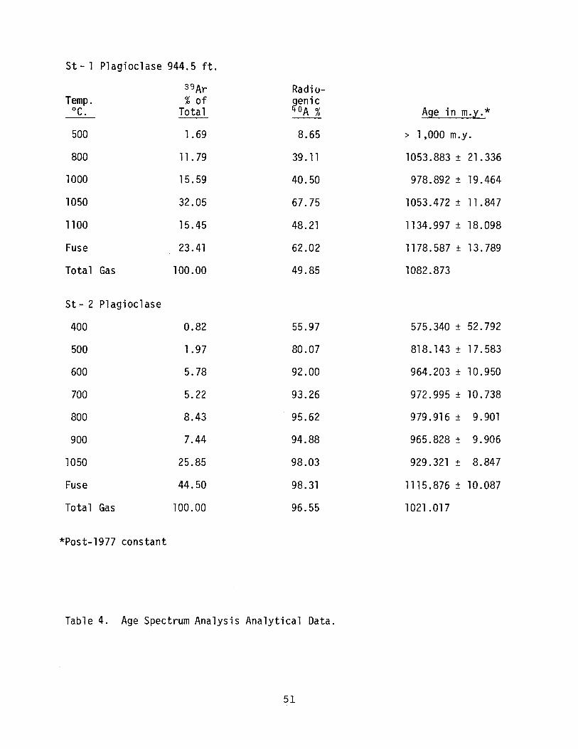
St - 1 Plagioclase 944.5 ft.
39Ar Radio-Temp. % of genic °e. Total /fDA % A' * ge ln m.y.
500 1.69 8.65 > 1,000 m.y.
800 11.79 39.11 1053.883 ± 21.336
1000 15.59 40.50 978.892 ± 19.464
1050 32.05 67.75 1053.472 ± 11. 847
1100 15.45 48.21 1134.997 ± 18.098
Fuse 23.41 62.02 1178.587 ± 13.789
Total Gas 100.00 49.85 1082.873
St - 2 Plagioclase
400 0.82 55.97 575.340 ± 52.792
500 1.97 80.07 818.143 ± 17.583
600 5.78 92.00 964.203 ± 10.950
700 5.22 93.26 972.995 ± 10.738
800 8.43 95.62 979.916 ± 9.901
900 7.44 94.88 965.828 ± 9.906
1050 25.85 98.03 929.321 ± 8.847
Fuse 44.50 98.31 1115.876 ± 10.087
Total Gas 100.00 96.55 1021.017
*Post-1977 constant
Table 4. Age Spectrum Analysis Analytical Data.
51

1220 fuse
t 1140 11 OO°C
1060 800°C 1050°C
>,
E 980 1000°C s:: .~
Q) a, 900 c:(
820
740 St-l 944.5 feet (plagioclase)
a 50 100 Cumulative percentage of 39Ar released
1220
1140 t tuse
1060 .
>,
E 980 s:: .~
~HnnV L9DU V I 60 I
Q) l lUbU V l en 900 c:(
820 St -2 1067.5 feet (plagioclase)
740 rr 500°C
o 50 100 Cumulative percentages of 39Ar released
Figure 30. 4oAr/ 39Ar age spectrum diagram for St-l and St-2.
52

Summary and Conclusions
The gabbroic rocks associated with the Steinhauer anomaly are intrusive
into older granitic rocks. They constitute a plug or plugs that occur on the
west flank of the Nemaha uplift to the south and northeast of the midcontinent
gravity high. The coarse-grained Steinhauer gabbros do not resemble the ophitic
basalts of the midcontinent gravity high in appearance or mineralogy. They also
appear to be older than the basalts in Nebraska (Goldich et ~., 1966). They do,
however, resemble the basalts in terms of their chemistry and, hence, may be
products of the same igneous event. Further, the Steinhauer gabbros resemble
the Keweenawan rocks of the Duluth gabbro as described by Weiblen and Morey
(1980). In light of the above, it seems that the Steinhauer gabbros are probably
an early intrusive phase of the igneous activity, in Nebraska, that gave rise to
the Keweenawan basaltic rocks of the midcontinent gravity high and the Keweenawan
basalts and gabbros of the Lake Superior region.
53
References
Brookins, D. G., Treves, S. B., and Bolivar, S. L. 1975. Elk Creek, Nebraska,
carbonatite: strontium geochemistry. Earth Planetary Science Letters,
v. 28, p. 79-82.
Dalrymple, G. B. and Lanphere, M. A. 1971. 4oAr/ 39 Ar technique of K-Ar dating:
a comparison with conventional technique. Earth and Planetary Science
Letters, v. 12, pp. 300-308.
Goldich, S. S., Lidiak, E. G., Hedge, C. E., and Walthall, F. G. 1966. Geochronology
of the Midcontinent Region, united States. Journal of Geophysical Research,
v. 71, pp. 5379-5407.
Nockolds, S. R. 1954. Average chemical composition of some igneous rocks.
Geological Society of America Bulletin, v. 65, pp. 1007-1032.
Treves, S. B., Smith, R., Carlson, M. P., and Coleman, G. 1972. Elk Creek
carbonatite, Johnson and Pawnee counties, Nebraska. Geological Society
of America Abstracts with Programs, v. 4, p. 297.
Treves, S. B., Smith, R., Rinehart, J., Coleman, G., and Carlson, M. P. 1972.
Petrography and mineralogy of the Elk Creek carbonatite, Nebraska.
Geological Society of America Abstracts with Programs, v. 4, p. 352.
Weiblen, P. W. and t1orey, G. B. 1980. A summary of the stratigraphy, petrology,
and structure of the Duluth complex. American Journal of Science, v. 280-A,
pp. 88-133.
54

APPENDIX A
This appendix consists of descriptions of the twenty-two
test holes drilled in central Otoe County. Locations of these
test holes are shown in figure 3 of the text.
All measurements in this appendix are expressed in feet.
To convert to the International System of Units, multiply feet
by .3048 to obtain meters.
55

Test Hole 1-81
Location: Otoe County, SW Sli NlV sec. 19, T. 8 N., R. 10 E., approximately 1950 feet south of north section line and 20 feet east of west section line.
Ground-level elevation: 1182.5 feet above mean sea level.
Started: I·1ay 7, 1981. Completed: Hay 7, 1981.
Description Depth, in feet
Quaternary System: Soil (no sample) ............................ . Clay, light yellowish brown; moderately
silty .................................... . Clay, light yellowish brown; contains
grave! ................................... . Clay, dark gray, slightly silty •••••••••••••• Clay, light greenish gray •••••••••••••••••••• Clay, olive, silty .......................... . Clay, medium to dark gray, slightly silty •••• Clay, I:ledium to dark gray, slighlty silty;
contains black carbonaceous material •••••• Clay, medium gray, slightly silty •••••••••••• Clay, light gray, slightly silty ••••••••••••• Clay, medium gray, slightly silty •••••••••••• Clay, light gray, slightly silty ••••••••••••• Clay, light gray, sandy, silty •••••••••••••••
From
0.0
5.0
10.0 23.0 37.5 48.0 52.5
66.0 69.0 83.0 86.0 88.0 92.0
Pennsylvanian System - Virgil Series - Habaunsee Group: Willard Formation:
Shale, light greenish gray ••••••••••••••••••• 96.0 Limestone, medium gray, very finely crys
talline; contains fusulinids •••••••••••••• Shale, pale olive ........................... . Shale, light reddish gray ••••••••••••••••••••
Emporia Formation: Elmont Member:
Limestone, medium gray to tan, finely crystalline, pseudo-oolitic; contains bryozoans, crinoids and Osagia ••••••••••••
Shale, light reddish gray •••••••••••••••••••• Limestone, very light gray, finely crys
talline; contains Osagia ••••••••••••••••••
56
97.2 97.8 99.0
100.1 102.8
103.7
To
5.0
10.0
23.0 37.5 48.0 52.5 66.0
69.0 83.0 86.0 88.0 92.0 96.0
97.2
97.8 99.0
100.1
102.8 103.7
105.4

Description Depth, in feet
From To
Harveyville Member: Shale, light to medium gray •••••••••••••••••• 105.4
Reading Member: Limestone, light gray, finely crystalline;
contains crinoids, brachiopods, and Osagia ................................... .
Shale, light to medium gray •••••••••••••••••• Limestone, medium gray, finely crystalline,
pseudo-oolitic in part; contains brachiopods and Osagia ••••••••••••••••••••
Auburn Formation: Shale, light greenish gray •••••••••.••••••••• Shale, red .................................. . Shale, red mottled tan ••••••••••••••••••••••• Shale, light greenish gray mottled olive ••••• Shale, medium to dark gray •••••••••••••••••••
\vakarusa Formation: Limestone, medium to dark gray, finely crys
talline; contains fusulinids; interbedded
106.9 110.0
110.2
113.0 114.0 123.2 126.0 130.0
with shale, medium gray ••••••••••••••••••• 138.2 Limestone, light gray, finely crystalline •••• 140.6
Soldier Creek Formation: Shale, medium gray ••••••••••••••••••••••••••• 142.7 Limestone, medium gray, finely crystalline;
contains fusulinids, crinoids, Osagia, and "black inclusions"; interbedded with shale, medium gray ....................... .
Shale, reddish gray ......................... . Limestone, light gray, very finely crys
talline; contains crinoids •••••••••••••••• Shale, dark gray ............................ . Limestone, light gray to tan, finely crys-
talline; contains Osagia •••••••••••••••••• Shale, medium gray .......................... . Shale, light gray •••••••••••••••••••••••••••• Shale, medium gray .......................... .
Burlingame Formation: Limestone, medium gray, finely crystalline ••• Limestone, medium gray, variably crystal
line; contains fusulinids, crinoids, brachiopods, pyrite, and "black
145.2 145.8
147.2 150.4
151.5 152.1 155.0 156.2
160.1
inclusions" ••••••••••••••••••••••••••••••• 161.0 Shale, light greenish gray ••••••••••••••••••• 161.6 Shale, light to medium gray •••••••••••••••••• 162.0 Limestone, light gray, very finely crys-
talline; contains brachiopods and glauconite •••••••••••••••••••••••••••••••• 163.5
Scranton Formation: Silver Lake - White Cloud Members:
Shale, pale olive •••••••••••••••••••••••••••• 164.8
57
106.9
110.0 110.2
113.0
114.0 123.2 126.0 130.0 138.2
140.6 142.7
145.2
145.8 147.2
150.4 151.5
152.1 155.0 156.2 160.1
161.0
161.6 162.0 163.5
164.8
167.0

Description
Shale, red mottled green ••••••••••••••••••••• Shale, light greenish gray ••••••••••••••••••• Shale, reddish gray ......................... . Shale, reddish gray: interbelided with lime
stone, light greenish gray •••••••••••••••• Shale, light greenish gray ••••••••••••••••••• Limestone, light greenish gray, finely
crystalline .............................. . Shale, pale alive ........................... . Shale, light gray •••••••••••••••••••••••••••• Coal, black ................................. . Shale, light greenish gray ••••••••••••••••••• Shale, light greenish gray; interbedded with
thin limestone streaks •••••••••••••••••••• Shale, raedium gray .......................... . Shale, light gray, silty .••••••••••••••••••••
Howard Formation: Limestone, medium to dark gray, finely
crystalline: contains abundant crinoids ••• Shale, dark gray ••••••••••••••••••••••••••••• Limestone, light to medium gray, very finely
crystalline: contains crinoids, fusulinids, pyrite, and "black
Depth,
From
167.0 167.2 170.0
178.3 182.9
183.0 183.9 184.5 194.0 194.5
213.3 213.5 240.3
242.0 243.3
inclusions" ••••••••••••••••••••••••••••••• 245.2 Severy Formation:
Shale, n1ediuln gray ••••••••••••••••••••••••••• 250.8 Coal, black .................................. 251.0 Shale, medium gray ••••••••••••••••••••••••••• 251.4
Test Hole 2-81
in feet
To
167.2 170.0 178.3
182.9 183.0
183.9 184.5 194.0 194.5 213.3
213.5 240.3 242.0
243.3 245.2
250.8
251.0 251.4 257.0
Location: Otoe County, NE corner SE sec. 17, T. 3 N., R. 10 E., approximately 2578 feet north of south section line and 22 feet west of east section line.
Ground-level elevation: 1152.0 feet above mean sea level.
Started: May 7, 1981. Completed: Hay 7, 1981.
Total depth: 227.0 feet.
Description
Quaternary System: Soil (no sample) ............................ .
58
Depth, in feet
FroP.l To
0.0 3.0

Description
Clay, yellowish brown; contains graveL •••••• Clay, yellowish brmYn; contains sand and
gravel ................................... . Clay, light brownish gray, slightly silty •••• Sand, coarse; contains gravel •••••••••••••••• Clay, tan, slightly silty •••••••••••••••••••• Clay, light brown ........................... . Clay, light brown to light gray •••••••••••••• Clay, medium gray to tan, silty •••••••••••••• Clay, medium gray, silty ••••••••••••••••••••• Clay, light to mediun gray, silty •••••••••••• Clay, light greenish gray, silty ••••••••••••• Clay, raedium greenish gray, silty •••••••••••• Clay, medium to dark gray, silty ••••••••••••• Clay, medium gray to greenish gray ••••••••••• Sand, fine to medium; contains gravel ••••••••
Depth,
From
3.0
7.0 10.0 17.0 19.0 23.5 24.0 31.0 42.0 47.0 54.5 59.5 64.3 68.0 79.5
Pennsylvanian System - Virgil Series - Wabaunsee Group: Auburn Formation:
Shale, pale olive •••••••••••••••••••••••••••• Shale, light greenish gray ••••••••••••••••••• Shale, light to medium gray ••••••••••••••••••
Wakarusa Formation: Limestone, medium gray, finely crystalline;
contains crinoids, fusulinids, brachio-
89.0 93.0 94.0
pods, and Osa~ia •••••••••••••••••••••••••• 103.5 Soldier Creek Formatlon:
Shale, medium gray ••••••••••••••••••••••••••• 107.4 Limestone, medium gray to tan, finely
crystalline ...•.............•...•......... 108.5 Limestone, light gray, finely crystalline,
pseudo-oolitic; contains Osagia and glauconite •••••••••••••••••••••••••••••••• 110.2
Shale, light gray •••••••••••••••••••••••••••• 114.2 Shale, medium gray ••••••••••••••••••••••••••• 117.0 Shale, light gray •••••••••••••••••••••••••••• 120.1
Burlingame Formation: Limestone, mediwu gray to tan, finely crys
talline; contains fusulinids and Osagia ••• 126.2 Shale, light gray •••••••••••••••••••••••••••• 127.5 Limestone, tan, finely crystalline; contains
fusulinids, Osagia, glauconite, and stylolites ................................ 128.6
Scranton Formation: Silver Lake - White Cloud N:embers:
Shale, light greenish gray mottled olive ••••• 131.0 Shale, light gray •••••••••••••••••••••••••••• 132.8 Shale, light gray; contains brown sandstone
streaks and pyrite •••••••••••••••••••••••• 150.5
59
in 'feet
To
7.0
10.0 17.0 19.0 23.5 24.0 31.0 42.0 47.0 54.5 59.5 64.3 68.0 1~.5 89.0
93.0 94.0
103.5
107.4
108.5
110.2
114.2 117.0 120.1 126.2
127.5 128.6
131.0
132.8 150.5
151. 0

Description Depth, in feet
Shale, light gray; contains brown sandstone streaks and black carbonaceous material •••
Shale, light gray; contains brown sandstone streaks .................................. .
Sandstone, medium to dark gray ••••••••••••••• Shale, light gray, silty ••••••••••••••••••••• Shale, medium gray mottled tan; contains
brown sandstone streaks ••••••••••••••••••• Shale, light gray; contains brown sandstone
streaks and trace of coal at 209.0 •••••••• Limestone, medium gray, very finely crys
talline; contains brachiopods, crinoins, and pyrite ............................... .
Shale, light gray; contains brown sandstone streaks .................................. .
Howard Formation: Limestone, medium gray, very finely crystal
line; contains crinoids and abundant
From
151. 0
163.4 179.3 180.1
192.0
198.4
212.0
212.2
fusulinids •••••••••••••••••••••••••••••••• 214.3 Limestone, light gray, very finely crystal
line; contains crinoids, fusulinids, Osagia, and pyrite •••••••••••••••••••••••• 216.2
Severy Formation: Shale, black, carbonaceous ••••••••••••••••••• 222.4 Shale, light gray •••••••••••••••••••••••••••• 222.7
Test Hole 3-81
Location: Otoe County, I-nv corner sec. 21, T. 8 N. R. 10 E., approximately 138 feet south of north section line and 18 feet east of west section line.
Ground-level elevation: 1170.0 feet above mean sea level.
Started: Hay 8, 1981. Completed: nay 8, 1981.
Total Depth: 182.0 feet.
To
163.4
179.3 180.1 192.0
198.4
212.0
212.2
214.3
216.2
222.4
222.7 227.0
Description Depth, in feet
Quaternary System: Soil (no sample) ............................ " Clay, brown ................................. . Clay, light brown to tan, sandy •••••••••••••• Clay, gray to tan, sandy ••••••••••••••••••••.
60
From To
0.0 6.0 6.0 18.0
18.0 22.0 22.0 25.0
Description
Clay, tan, very sandy ....................... . Clay, brown, very sandy •••••••••••••••••••••• Clay, light brown, sandy ••••••••••••••••••••• Sand, fine .................................. . Clay, light brown, very sandy •••••••••••••••• Clay, light gray, silty •••••••••••••••••••••• Clay, medimG gray, very sandy •••••••••••••••• Clay, dark gray •••••••••••••••••••••••••••••• Clay, light gray, silty, sandy ••••••••••••••• Clay, greenish gray, sandy •••••••••••••••••••
Depth,
From
25.0 32.0 44.0 51.0 54.5 59.0 62.5 71.0 76.5 88.0
Pennsylvanian System - Virgil Series - Wabaunsee Group: Auburn Formation:
Shale I red .................................. . Shale, olive, mottled yellow and red ••••••••• Shale, eli ve ................................ . Shale, medium gray .......................... .
Wakarusa Formation: Limestone, medium gray, finely crystalline;
contains crinoids, fusulinids, brachio-pods, and pyrite ......................... .
Limestone, medium gray, finely crystalline; contains fusulinids, pyrite, and "black incl USiOllS" •••••••••••••••••••••••••••••••
Soldier Creek Formation: Shale, medium gray .......................... . Limestone, light gray to tan, very finely
crystalline; interbedded with shale, light greenish gray •••••••••••••••••••••••
Shale, reddish gray ......................... . Shale, light greenish gray mottled red ••••••• Limestone, light gray, very finely crystal-
line; contains Osagia and glauconite •••••• Shale, light greenish gray ••••••••••••••••••• Shale, light gray •••••••••••••••••••••••••••• Shale, medium gray ............•..............
Burlingame Formation: Limestone, medium gray, finely crystalline ••• Shale, ligllt gray ........................... . Limestone, light gray, very finely crystal
line; contains glauconite ••••••••••• ~ ••••• Limestone, light greenish gray, finely crys
talline; contains abundant glauconite ••••• Scranton Formation: Silver Lake - White Cloud Hembers:
Sandstone, tan; interbedded with shale,
95.5 98.5
100.3 103.0
112.8
115.0
117.2
118.3 120.0 121.1
121.8 123.8 127.0 130.0
135.1 135.6
136.8
137.5
greenish gray ••••••••••••••••••••••••••••• 139.3 Shale, black, carbonaceous ••••••••••••••••••• 141.8 Shale, light greenish gray ••••••••••••••••••• 142.2 Shale, red ••••••••••••••••••••••••••••••••••• 145.0
61
in feet
To
32.0 44.0 51.0 54.5 59.0 62.5 71.0 76.5 88.0 95.5
98.5 100.3 103.0 112.8
115.0
117.2
118.3
120.0 121.1 121.8
123.8 127.0 130.0 135.1
135.6 136.8
137.5
139.3
141.8 142.2 145.0 149.5

Description
Shale, green mottled red ••••••••••••••••••••• Shale, red mottled green ••••••••••••••••••••• Shale, green mottled red ••••••••••••••••••••• Shale, red mottled green ••••••••••••••••••••• Shale, olive mottled red ••••••••••••••••••••• Shale, nledium gray .......................... . Coal, black ................................. . Shale, medi urn gray .......................... .
Test Hole 4-81
Depth, in
From
149.5 151.0 155.3 155.9 158.5 159.5 167.2 167.5
Location: Otoe County, SE corner HE HE SE sec. 5, T. 8 N.,
feet
To
151.0 155.3 155.9 158.5 159.5 167.2 167.5 182.0
R. 10 E., approximately 2012 feet north of south section line and 30 feet west of east section line.
Ground-level Elevation: 1149.0 feet above mean sea level.
Started: Hay 8, 1981. Completed: Hay 8, 1981.
Total Depth: 137.0 feet.
Description
Quaternary System: Soil (no sample) ............................ . Clay, brown, silty .......................... . Clay, light tan, very silty •••••••••••••••••• Clay, light tan, sandy ••••••••••••••••••••••• Clay, tan, silty ............................ . Clay, gray, sandy, silty ••••••••••••••••••••• Clay, medium gray, sandy ••••••••••••••••••••• Clay, light gray, sandy •••••••••••••••••.•••• Clay, medium gray, sandy ••••••••••••••••••••• Clay, medium gray; contains gravel •••••••••••
Depth,
From
0.0 3.0 6.5
20.0 38.5 43.0 47.0 51.0 62.0 69.0
Pennsylvanian Series - Virgil Series - lVabaunsee Group: Auburn Formation:
Shale, olive................................. 74.5 Wakarusa Formation:
Limestone, medirnn gray, finely crystalline; interbedded with shale, medium gray ••••••• 76.8
Shale, black; contains carbonaceous material .••••••••••••••••••••••••••••••••• 79.6
62
in feet
To
3.0 6.5
20.0 38.5 43.0 47.0 51. 0 62.0 69.0 74.5
76.8
79.6
80.0

Description
Limestone, medium gray, finely to very finely crystalline; contains brachiopods and pyrite ................ e,_ ••••••••••••••
Soldier Creek Formation: Shale, medium gray .......................... . Shale, reddish gray .....•.................... Limestone, light gray, very finely
crystalline .............................. . Shale, gray to tan .......................... . Shale, medium gray .......................... . Shale, dark gray •••••••••••••••••••••••••••••
Burlingame Formation: Limestone, medima gray, finely crystalline;
contains gastropods and pyrite •••••••••••• Limestone, medium gray, variably crystal
line; contains Osagia ••••••••••••••••••••• Scranton Formation: Silver Lake - White Cloud Hembers:
Shale, medium greenish gray •••••••••••••••••• Shale, medium olive gray ••••••••••••••••••••• Shale, grayish red .......................... . Shale, light green .........•..••............. Shale, dark red ............................. . Shale, red .................................. . Shale, red; interbedded with limestone,
gray ..................................... . Shale, dark red ............................. . Shale I alive ................................ . Shale, medium gray .......................... . Shale, light gray •••••••••••••••••••••••••••• Coal, black ................................. . Shale, light gray •••••••••••••••••••••••••••• Shale, rnedi urn gray .......................... .
Test Hole 5-81
Depth, in 'feet
From To
80.0 80.4
80.4 82.0 82.0 84.2
84.2 86.1 86.1 87.8 87.8 92.0 92.0 98.3
98.3 100.4
100.4 101.4
101.4 102.6 102.6 104.3 104.3 105.0 105.0 108.0 108.0 111.5 111.5 115.0
115.0 115.5 115.5 118.0 118.0 118.8 118.8 126.7 126.7 128.0 128.0 128.4 128.4 130.0 130.0 137.0
Location: Otoe County, SE corner sec. 4, T. B N., R. 10 E., approximately 94 feet north of south section line and 15 feet west of east section line.
Ground-level elevation: 1159.5 feet above mean sea level.
Started: t1ay 11, 1981. Completed: May 11, 1981.
Total Depth: 136.0 feet.
63

Description
Quaternary System: Soil (no sample} ............................ . Clay, brown, silty, sandy •••••••••••••••••••• Clay, light brown, silty, sandy •.•••••••••••• Clay, medium gray to brown, silty, sandy ••••• Clay, brown, sandy .......................... . Clay, brown, very sandy •••••••••••••••••••••• Clay, medium gray to brown, sandy •••••••••••• Clay, medium gray, slightly sandy ••••••••••••
Depth,
From
0.0 3.0 6.5
11.0 14.5 17.0 24.5 38.0
Pennsylvanian System - Virgil Series - Wabaunsee Group: Emporia Formation:
Reading Hember: Limestone, light gray, finely crystalline •••• Shale, medium gray ...•......••...•.....•••..• Limestone, tan, weathered, finely crystal
line; contains fusulinids, crinoids, Osagia and manganese staining •••••••••••••
Auburn Formation: Shale, olive ................................ . Shale, red .................................. . Shale, red mottled green ••••••••••••••••••••• Shale, red .................................. . Shale, red; interbedded with limestone,
medium gray .............................. . Shale, green mottled red ••••••••••••••••••••• Shale, medium gray ......•........•...........
Wakarusa Formation: Limestone, medium gray, finely crystalline;
interbedded with shale, medium gray ••••••• Limestone, medium gray, finely crystalline;
contains fusulinids and brachiopods ••••••• Limestone, light to medium gray, finely
crystalline; contains fusulinids •••••••••• Soldier Creek Formation:
Shale, medium gray mottled red ••••••••••••••• Limestone, medium gray, very finely
crystalline ••••••••••••••••••••••••••••••• Shale, medium reddish gray ••••••••••••••••••• Shale I nledium. gray .......................... . Limestone, light gray, finely crystalline;
contains Osagia .......•.•...........•..•• Limestone, light gray, very finely crystal
line; contains glauconite ••••••••••••••••• Shale, Iaedium gray ......................... ' ..
Burlingame Formation: Limestone, medium gray, finely crystalline;
contains "black inclusions" ••••••••••••••• Shale, medium greenish gray •••••••••••••••••• Limestone, light gray, very finely crystal
line; interbedded with shale, red •••••••••
64
43.4 44.9
46.2
48.1 50.1 58.0 59.0
63.7 66.5 70.8
79.3
80.3
83.2
84.0
85.3 86.2 87.2
88.6
89.6 91.8
101.2 103.1
104.2
in feet
To
3.0 6.5
11.0 14.5 17.0 24.5 38.0 43.4
44.9 46.2
48.1
50.1 58.0 59.0 63.7
66.5 70.8 79.3
80.3
83.2
84.0
85.3
86.2 87.2 88.6
89.6
91. 8 101.2
103.1 104.2
106.5

Description Depth, in feet
From To
Scranton Formation: Silver Lake - White Cloud l1embers:
Shale, red .................................. . Shale, red mottled gray •••••••••••••••••••••• Shale, green ................................ . Shale I red .................................. . Shale, red; interbedded with limestone,
rnedi urn gray ••••••••••••••••••••••••••••••• Shale I light gray ........................... . Shale, medium gray ....•...................... Limestone, medium gray, very finely crys
talline; contains Osagia; interbedded with shale, dark gray •••••••••••••••••••••
Shale, light gray •••••••••••••••••••••••••••• Coal, black ................................. . Shale, medium gray .......................... .
Test Hole 6-81
106.5 107.0 109.2 110.2
117.2 120.1 122.3
123.1 123.3 129.8 130.2
Location: Otoe County, SW corner sec. 1, T. 8 N., R. 10 E., approximately 207 feet north of south section line and 103 feet east of west section line.
Ground-level elevation: 1133.5 feet above mean sea level.
Started: May 11, 1981. COI'.1pleted: Hay 11, 1981.
Total Depth: 205.0 feet.
107.0 109.2 110.2 117.2
120.1 122.3 123.1
123.3 129.8 130.2 136.0
Description Depth, in feet
Quaternary System: Soil (no sanlple) ............................ . Clay, gray to tan, sandy ••••••••••••••••••••• Clay, gray, silty, sandy ••••••••••••••••••••• Clay, gray to brown, silty, sandy •••••••••••• Clay, gray, sandy •••••••••••••••••••••••••••• Clay, brown to gray, sandy ••••••••••••••••••• Clay, gray, sandy •••••••••••••••••••••••••••• Clay, gray, very silty, sandy •••••••••••••••• Clay, dark gray, very silty, sandy •••••••••••
65
From
0.0 4.5
10.0 19.0 25.0 32.0 38.5 47.0
105.5
To
4.5 10.0 19.0 25.0 32.0 38.5 47.0
105.5 108.9

Description Depth, in feet
From To
Pennsylvanian System - Virgil Series - Wabaunsee Group: Burlingame Formation:
Shale, gray to dark gray ••••••••••••••••••••• Shale, olive ................................ . Shale, olive, interbedded with limestone,
gray ..................................... . Shale, Itledi urn gray .......................... . Limestone, gray to tan, variably crystal
line; contains glauconite; interbedded witll shale, olive ........................ .
Scranton Formation: Silver Lake - White Cloud aerrbers:
Shale, light green .......................... . Shale, black ••••••••••••••••••••••••••••••••• Shale, medium greenish gray •••••••••••••••••• Shale, red mottled green ••••••••••••••••••••• Shale, light gray •••••••••••••••••••••••••••• Coal, black ................................. . Shale, light gray ........................... . Shale, medium gray .......................... .
Howard Formation: Limestone, light gray, finely crystalline;
contains brachiopods; interbedded with shale, medium gray ....................... .
Limestone, medium gray, very finely crystalline; interbedded with shale, medium gray ..................................... .
Shale, medium gray ............•.............. Limestone medium gray, very finely crystal
line; contains fusulinids, Osagia, and "black inclusions" ••••••••••••••••••••••••
Limestone, light gray to tan, very finely crystalline; contains fusulinids, Osagia, and coarsely crystalline calcite streaks ••
Severy Formation: Coal, black •••••••••••••••••••••••••••••••••• Siltstone, light gray ••••••••••••••••••••••••
Test Hole 7-81
108.9 109.3
110.2 111.4
112.1
113.0 114.8 115.4 123.5 134.2 139.5 139.9 167.0
188.3
190.4 190.7
193.4
194.7
198.6 199.4
Location: Otoe County, HE corner SE NE sec. 14, T. 8 H.,
109.3 110.2
111.4 112.1
113.0
114.8 115.4 123.5 134.2 139.5 139.9 167.0 188.3
190.4
190.7 193.4
194.7
198.6
199.4 205.0
R. 10 E., approximately 1920 feet south of north section line and 19 feet west of east section line.
Ground-level elevation: l124.S feet above mean sea level.
Started: May 11, 1981. Completed: H.ay 11, 1981.
66

Total Depth: 130.0 feet.
Description
Quaternary System: Soil (no salTLple) ••••••••••••••••••••••••••••• Clay, medium gray, very sandy •••••••••••••.•• Clay, tan to medium gray, sandy •••••••••••••• Clay, tan, sandy ............................ .
Depth,
From
0.0 6.0
10.0 15.0
Pennsylvanian System - Virgil Series - \vabaunsee Group: Willard Formation:
Shale, medium gray; contains sandstone streaks .................................. .
Shale, light gray; contains sandstone streaks .................................. .
Shale, rLledium gray .......................... . Shale, medium gray, sandy •••••.•••••••••••••• Shale,medium greenish gray •••••••••••••••••• Shale, green mottled red ••••••.•••••••••••••• Shale, red and green ........................ .
Emporia Formation: Elmont - Reading Hembers:
Limestone, medium gray, finely crystalline, pseudo-oolitic; contains glauconite and pyri te ................................... .
Shale, red .................................. . Shale, medium gray; interbedded with lime-
stone, medium gray •••••••••••••••••••••••• Limestone, light gray, very finely crystal
line; contains Osagia and coarsely crystalline calcite streaks •••••••••••••••••••
Shale, nledi urn gray .......................... . Limestone, light gray to tan, very finely
crystalline; contains brachiopods, fusulinids, Osagia, and glauconite ••••••••
Auburn Formation: Shale, light green .......................... . Shale, red .................................. . Shale, red mottled green •••••.••••••••••••••• Shale, red .................................. . Shale, red, very sandy ••••••••••••••••••••••• Shale, eli ve ................................ . Shale, grayish green ........................ . Shale, medium gray .......................... .
Wakarusa Formation: Limestone, medium gray, finely crystalline;
contains brachiopods, fusulinids, and
17.0
23.0 32.0 44.5 48.5 51.0 52.0
53.4 54.2
56.4
56.8 58.5
59.8
62.2 63.5 71.2 71.6 77.5 81.0 83.6 85.2
py rite. . . . . . . . . . . . . . . . . . . . . . . . . . . . . . . . . . . . 9 3 . 3
67
in feet
To
6.0 10.0 15.0 17.0
23.0
32.0 44.5 48.5 51.0 52.0 53.4
54.2 56.4
56.8
58.5 59.8
62.2
63.5 71. 2 71.6 77.5 81.0 83.6 85.2 93.3
93.9

Description
Limestone, medium gray, finely crystalline; contains brachiopods, Osagia, "black inclusions," and abundant fusulinids; interbedded with shale, green ..........•..
Soldier Creek Formation: Shale, medium gray .......................... . Shale, light grayish green ......•............ Limestone, light gray to tan, finely
crystalline; contains Osagia ............. . Shale, medium. gray .......................... . Shale, medium olive gray ••.•................. Shale, medium gray ......•.........•..........
Burlingame Formation: Limestone, light greenish gray, finely
crystalline; contains glauconite, pyrite, and "black inclusions" ...•...........•....
Scranton Formation: Silver Lake - White Cloud Hembers:
Shale, medium greenish gray ...•.............. Shale, black ................................ . Shale, grayish green .......•................. Shale, light green ........•..................
Test Hole 8-81
Depth, in feet
From To
93.9 98.2
98.2 100.7 100.7 103.2
103.2 105.1 105.1 107.8 107.8 110.5 110.5 116.1
116.1 119.9
119.9 121.2 121. 2 122.7 122.7 127.5 127.5 130.0
Location: Otoe County, SW Nlv S\"l sec. 7, T. 8 N., R. 11 E., approximately 1700 feet north of south section line and 20 feet east of west section line.
Ground-level elevation: 1093.0 feet above mean sea level.
Started: May 13, 1981. Completed: May 13, 1981.
Total Depth: 122.0 feet.
Description
Quaternary System: Soil (no saniple) ............................ . Clay, light brown, sandy .................... . Clay, light brown, very sandy ............... . Clay, brown, sandy, silty ................... . Clay, brown, sandy .......................... .
68
Del2th, in
From
0.0 4.0
11. 5 15.5 21. 0
feet
To
4.0 11.5 15.5 21.0 26.0

Description Depth, in feet
From To
Pennsylvanian System - Virgil Series - Wabaunsee Group: Auburn Formation:
Shale, red, very sandy ••••••••••••••••••••••• Shale, red, and siltstone, red •.••••••••••••• Shale, olive ................................ . Shale, greenish gray ••••••••••••••••••••••••• Shale, rrledium gray .......................... . Shale, medium gray; contains abundant
pyri te ................................... . Wakarusa Formation:
Shale, medium gray; interbedded with lime-stone, gray_ ............................. .
Limestone, medium gray, finely crystalline; contains brachiopods ••••••••••••••••••••••
Shale, black ................................ . Limestone, medium gray, finely crystalline;
contains brachiopods •••••••••••••••••••••• Shale, black ................................ . Limestone, nediurr, gray, finely crystal
line; contains fusulinids and brachiopods •••••••••••••••••••••••••••••••
Soldier Creek Formation: Shale, light gray ........................... . Limestone, light gray to tan, very finely
crystalline; contains fusulinids •••••••••• Shale, red .................................. . Shale, red mottled green ••••••••••••••••••••• Limestone, light gray, very finely crystal-
line; contains Osagia ••••••••••••••••••••• Limestone, light greenish gray, very finely
crystalline; contains fusulinids, Osagia, and glauconite ••••••••••••••••••••••••••••
Shale, light green ••••••••••••••••••••••••••• Shale, light gray ........................... . Shale, olive gray ........................... . Shale, medi urn gray .......................... . Shale, medium to very dark gray ••••••••••••••
Burlingame Formation: Limestone, medium to dark gray, finely
crystalline; contains Osagia •••••••••••••• Limestone, medium gray, very finely crystal
line; contains "black inclusions" and pyri te ................................... .
Limestone, medium gray, finely crystalline; contains fusulinids, Osagia, glauconite, pyrite, and "black inclusions" ••••••••••••
Limestone, light greenish gray, very finely crystalline; contains Osagia and glauconi te ............................... .
69
26.0 27.2 27.2 32.7 32.7 35.0 35.0 36.8 36.8 41.2
41.2 47.2
47.2 48.1
48.1 49.4 49.4 49.5
49.5 50.6 50.6 50.8
50.8 51.9
51.9 53.4
53.4 53.9 53.9 55.0 55.0 56.1
56.1 57.0
57.0 59.6 59.6 60.2 60.2 62.3 62.3 63.0 63.0 71.2 71.2 71.4
71. 4 71.6
71.6 73.0
73.0 74.2
74.2 75.1

Description Depth, in feet
From To
Scranton Formation: Silver Lake - White Cloud Hembers:
Shale, light grayish green ••••••••••••••••••• Shale, dark gray ............................ . Shale I rnedium gray .......................... . Shale, light green ...........•............... Shale, red .................................. . Shale, red; interbedded with limestone,
gray ..................................... . Shale, red mottled green ••••••••••••••••••••• Shale, red .................................. . Shale, red mottled green ••••••••••••••••••••• Shale, light gray •••••••••••••••••••••••••••• Limestone, medium greenish gray, medium
crystalline; contains abundant brachiopods •••••••.•••••••••••••••••.•••••
Shale, medium gray .......................... . Coal, black ................................. . Shale, light greenish gray ••••••••••••••••••• Shale, black ................................ . Shale, light gray ••••••••••••••••••••••••••••
Test Hole 9-81
75.1 75.6 77.5 79.0 84.4
87.8 90.1 90.3 92.0 93.5
95.1 95.4 96.5 97.0
102.4 102.6
Location: Otoe County, NW NE NW sec. 19, T. 8 N., R. 11 E., approximately 19 feet south of north section line and 1775 feet east of west section line.
Ground-level elevation: 1160.0 feet above mean sea level.
Started: May 13, 1981. Completed: Hay 13, 1981.
Total Depth: 120.0 feet.
Description
Quaternary System: Soil (no sarrl.ple) ............................ . Clay, brown, sandy ................•.•...••... Clay, medium gray to brown, sandy •••••••••••• Clay, light brown, very sandy •••••••••••••••• Clay, olive, sandy .......................... . Clay, tan, sandy ............................ .
70
Depth, in
From
0.0 3.0 4.5 6.0 8.0
10.0
75.6 77.5 79.0 84.4 87.8
90.1 90.3 92.0 93.5 95.1
95.4 96.5 97.0
102.4 102.6 122.0
feet
To
3.0 4.5 6.0 8.0
10.0 10.5

Description Depth, in feet
From To
Permian System - Big Blue Series - Council Grove Group: Red Eagle Formation: Bennett Member:
(no sample) •.•••••..••••••••••••••••.•••••••• Glenrock Member:
(no saznple) •••••••..••.••••••••••••.•.••••••• Johnson Formation:
(no sample) ••.••.•••••••••••••••••••••••.•••• Limestone, olive to mediilln gray, very finely
crys tall ine .............................. . Limestone, light gray, very finely
crystalline .............................. . Shale, grayish green ........................ . Limestone, medium greenish gray, very finely
crys tal line ..•....••..••..•.••..•.......•. Limestone, gray to pale red, very finely
crystalline .............................. . Shale, green ................................ . Shale, tan, limy ............................ .
Foraker Formation: Long Creek Member:
Limestone, tan, very finely crystalline •••••• Limestone, medium gray, very finely
crystalline .............................. . Limestone, tan, very finely crystalline •••••• Limestone, medium gray, finely crystalline •••
Hughes Creek Menilier: Shale, dark gray; interbedded \vith lime-
stone, rnedium gray ....................... . Limestone, mediura gray, medium to finely
crystalline; contains fusulinids, brachiopods, crinoids, and Osagia •••••••••
Shale, light gray ........................... . Shale, medium gray; interbedded with lime-
stone, medium gray ........•.•......•....•. Shale, medium to dark gray ••••••••••••••••••• Limestone, light gray to roodium gray, finely
crystalline; contains brachiopods, fusulinids, and pyrite ••••••••••••••••••••
Shale, light gray •••••••••••••••••••••••••••• Limestone, light gray, finely crystalline;
contains brachiopods and crinoids; interbedded with shale, light gray ••••••••
Shale, light gray .•.•.....•...•...•.....••.•. Shale, light grayish green ••••••••••••••••••• Limestone, medium gray, finely crystalline ••• Shale, very dark gray •••••••••••••••••••••••• Limestone, medium gray, finely crystalline;
contains Osagia and "black inclusions" •••• Shale, medium gray ............•..............
71
10.5 15.5
15.5 17.0
17.0 20.0
20.0 21.0
21.0 23.0 23.0 23.5
23.5 24.0
24.0 2"7.4 27.4 27.5 27.5 28.5
28.5 30.0
30.0 30.4 30.4 32.5 32.5 34.0
34.0 38.8
38.8 41.1 41.1 41.8
41.8 45.0 45.0 47.5
47.5 48.4 48.4 50.0
50.0 51.6 51.6 52.0 52.0 53.9 53.9 55.1 55.1 56.8
56.8 58.4 58.4 59.0

Description
Limestone, dark gray, finely crystalline; contains Osagia •••••••••••••••••••••••••••
Shale, medium gray .......................... . Limestone, medium gray, finely crystalline ••• Shale, medium gray .......................... . Limestone, medimn gray, medium crystalline;
contains brachiopods, crinoids, fusulinids, and Osagia •••••••..•.••••••.••
Limestone, medium gray, finely crystalline; contains crinoids, fusulinids, brachiopods, and "black inclusions" ••••.•••..••••
Limestone, light gray, finely crystalline; contains abundant crinoids; interbedded with shale, medium gray .••••••••••••••••••
Shale, medium to very dark gray •••••.•••••••• Limestone, medium gray, very finely
crystalline .............................. . Shale, medium to dark gray ••••••••••••••••••• Limestone, medium gray, finely crystalline ••• Shale, medium greenish gray •••••••••••••••••• Shale, medium gray .......................... . Limestone, medium gray, finely crystalline;
contains brachiopods, Osagia, and "black inclusions" .............................. .
Shale, medium gray .......................... . Shale, black ................................ .
Americus Member: Limestone, medimn gray, very finely crystal
line; contains brachiopods, bryozoans, and black carbonaceous material •••••••••.•
Shale, dark gray ••••••••••••••••••••.•••••••• Limestone, light gray, finely crystalline;
contains crinoids; interbedded with shale, dark gray ••••••••••••••••••••••••••
Limestone, medium gray, finely crystalline; contains brachiopods and fusulinids •••••••
Shale, medium to dark gray •.••••••••••••••••• Limestone, light gray, very finely crystal
line; contains brachiopods and crinoids •••
Admire Group: West Branch - Hamlin Formations:
Shale, light gray •••••••••••••••••••••••••••• Limestone, medium gray, very finely
crystalline •••••.••••••••••••••••••••••••• Shale, medium gray .......................... . Limestone, medium gray, very finely crystal
line; contains pyrite •••••••.••••••.•••••. Shale, nLedium gray .......................... .
72
DeEth,
From
59.0 59.2 60.7 61.1
61.6
63.3
64.0 64.5
65.0 65.6 65.9 67.1 68.1
69.0 71.4 74.1
74.3 75.8
76.8
77.0 77.3
77.7
78.1
82.3 82.6
88.1 88.3
in feet
To
59.2 60.7 61.1 61.6
63.3
64.0
64.5 65.0
65.6 65.9 67.1 68.1 69.0
71.4 74.1 74.3
75.8 76.8
77.0
77.3 77.7
78.1
82.3
82.6 88.1
88.3 88.9

Description
Limestone, medium gray, finely crystalline; contains brachiopons, Osagia, and pyrite ••
Shale, green ..... ~ .......................... . Shale, reddish green ..•••••••••••.••••••••••• Shale, greell ................................ . Limestone, cream, very finely crystalline •.•• Shal e I greell ................................ . Shale, red .................................. . Shale, medium gray .......................... . Limestone, light gray, very finely
crystalline ••••••••••••••••••••••••••••••• Shale, grayish green ••••••••••••••••••••••••. Shale, red .................................. . Shale, olive ................................ . Shale, red mottled green •••••.•••••••••••.••. Shale, eli ve ................................ . Limestone, very light gray, very finely
crystalline; contains glauconite •••••••••• Shale, red; interbedded with limestone,
gray ..................................... . Shale I eli ve ................................ . Shale, green; interbedded with limestone,
gray ..................................... . Shale, red .................................. . Shale, green ................................ . Shale , olive ................................ . Shale, medium gray •.....•............•....... Shale, green ................................ . Shale, light gray •••••••••••••••••••••••••••• Shale, dark green •••••••••••••••.•••••••••••• Shale, green; interbedded with limestone,
g-ray ............•.....•••................. Shale, red mottled green ••••••••••••••••••••• Limestone, light greenish gray, very finely
crystalline; contains glauconite ••••••••••
Test Hole 10-81
Depth,
From
88.9 90.1 92.0 93.8 94.7 95.8 96.0 97.0
97.4 98.0 98.4 99.0 99.5
100.0
100.3
102.5 104.0
104.4 106.2 108.2 109.0 109.8 111.0 112.1 113.8
114.5 115.8
116.9
in feet
To
90.1 92.0 93.8 94.7 95.8 96.0 97.0 97.4
98.0 98.4 99.0 99.5
100.0 100.3
102.5
104.0 104.4
106.2 108.2 109.0 109.8 Ill. 0 112.1 113.8 114.5
115.8 116.9
120.0
Location: Otoe County, NE corner SE sec. 30, T. 8 N., R. 11 E., approximately 2463 feet north of south section line and 20 feet west of east section line.
Ground-level elevation: 1136.5 feet above mean sea level.
Started: Hay 14, 1981. Completed: Hay 14, 1981.
Total Depth: 130.0 feet.
73

Description
Quaternary System: Soil (no sample) ............................ . Clay, Sand, Clay, Clay, Clay, Clay,
tan, sandy ............................ . medi l.lIn ••••••••••••••••••••••••••••••••• tan, sandy ............................ . brown, sandy .......................... . tan ................................... . brown ................................. .
Depth,
From
0.0 3.0 8.2 8.5
21.0 26.0 28.0
Permian System - Big Blue Series - Council Grove Group: Foraker Formation:
Hughes Creek Member: Shale, olive~ interbedded with limestone,
gray ..................................... . Shale, olive gray~ interbedded with liroe-
stone, gray .............................. . Limestone, medium gray, finely crystalline ••• Shale, olive ................................ . Limestone, tan, finely crystalline~ contains
brachiopods and "black inclusions" ••••••.• Limestone, medium gray to tan, finely crys
talline~ contains brachiopods and "black illCl usions" .............................. .
Shale, olive~ interbedded with limestone, gr ay ..................................... .
Shale, dark g"ray ............................ . Limestone, medium gray, finely crystalline,
pseudo-oolitic~ contains brachiopods .•••.• Shale, rnedi urn, gray .......................... . Limestone, medium gray, finely crystalline~
contains Osagia ••••.••••••.•••••••.•.••••• Sllale, rnediurn gray .......................... . Shale, black ................................ .
Americus Member: Limestone, mediUI:1 to dark gray, very finely
crystalline~ contains fusulinids and brachiopods ••.•.••••••••••••..••••.•.••.•.
Sllale, dark gray ............................ . Limestone, medium gray, very finely crystal
line~ contains fusulinids and brachio-pods •....•••••.••.•••••..••••.•.•..•.•..•.
Shale, dark gray ••••••••••••••••••••••••••••• Limestone, medimu gray, very finely
crys tall ine .............................. . Shale, dark gray ............................ . Limestone, medium gray, finely crystalline~
contains brachiopods •..•.•••••••••••.••••.
74
32.0
34.3 37.5 37.9
38.6
39.0
40.1 41. 0
42.4 43.0
43.1 44.8 47.8
48.2 49.2
50.1 50.2
50.7 51. 3
51. 5
in feet
To
3.0 3.2 8.5
21.0 26.0 28.0 32.0
34.3
37.5 37.9 38.6
39.0
40.1
41. 0 42.4
43.0 43.1
44.8 47.8 43.2
49.2 50.1
50.2 50.7
51.3 51. 5
52.0

Description
Admire Group: Hamlin Formation:
Oaks Member: Sllale, medium gray .......................... . Limestone, medium gray, very finely crystal
line; contains crinoids ............•...... Shale, mediurn gray .......................... . Limestone, medium gray, very finely crystal-
line; contains fusulinids ................ . Shale, light green .......................... . Limestone, very light gray, lithographic;
interbedded with shale, green ............ . Shale, green to gray ........................ . Shale, red mottled green .................... . Shale, green ................................ . Shale, dark gray ............................ .
Houchens Creek Member: Limestone, light gray, finely crystalline ••••
Stine Member: Shale, alive gray ........................... . S11ale, green ................................ . Limestone, medium gray, finely crystalline ••• Shale, red mottled green ..............•..•... Shale, light gray ........................... . Limestone, light greenish gray, finely
crystalline; contains Osagia and abundant glauconi te ............................... .
Shale, medium olive gray ...•................. Shale, eli ve ................................ . Sllale, medium gray .......................... . Shale, dark gray ............................ .
Five Point Formation: Limestone, light gray, finely crystalline;
contains crinoids, brachiopods, Osagia, and glauconite ........................... .
West Branch Formation: Shale, light gray ........................... . Shal e, green ................................ . Shale, reddish gray ......................... . Limestone, light gray, very finely
crystalline .............................. . Shale, light green .......................... . Shale, light gray ......................•..... Shale, black ................................ . Shale, light gray ........................... .
Falls City Fonnation: LehIner Member:
Limestone, light gray, very finely crystal-
Depth, in feet
From To
52.0 57.1
57.1 57.8 57.8 58.5
58.5 59.6 59.6 62.0
62.0 63.5 63.5 65.0 65.0 66.8 66.8 67.5 67.5 69.3
69.3 70.1
70.1 72.0 72.0 72.7 72.7 73.8 73.8 74.7 74.7 75.9
75.9 77.2 77.2 78.8 78.8 79.8 79.8 81.5 81. 5 85.0
85.0 86.2
86.2 88.1 88.1 89.3 89.3 91.0
91.0 92.1 92.1 93.4 93.4 100.0
100.0 100.5 100.5 102.1
line ...................................... 102.1 104.0
75

Description Depth, in feet
From To
Limestone, medium gray, very finely crysta1-1ine~ contains pyrite and "black inclusions" •••••••.•••••••••••••••••••••••
Shale, light grayish green~ interbedded with limestone, light gray •••••••••••••••••••••
Reserve Hember: Shale, medi urn gray .......................... .
Miles Member: Limestone, medium gray, very finely
crystalline .............................. . Onaga Formation:
Shale I rnedi urn gray .......................... . Shale, green~ interbedded with limestone,
gray ...... " . .............................. . Shale, light green ••••••••••••••••••••••••••• Shale, very light green •••••••••••••••••••••• Shale, green ................................ . Shale, red .................................. . Shale, eli ve ................................ . Limestone, light greenish gray, very finely
crystalline ••••••••••••••••••••••••••••••• Shale, red .................................. . Shale, light gray ••••••••••••••••••••••••••••
104.0
107.0
108.9
110.2
111.0
111.4 112.0 113.0 115.0 117.4 119.7
119.9 120.7 124.5
Pennsylvanian System - Virgil Series - l"1abaunsee Group: Wood Siding Formation:
Brownville Hember: Limestone, light gray, finely crysta11ine~
contains Osagia ••••••••••••••••••••••••••• 127.7 Shale, light gray •••••••••••••••••••••••••••• 129.4
Test Hole 11-81
Location: Otoe County, SW corner sec. 25, T. 9 N., R. 11 E., approximately 205 feet north of south section line and 21 feet east of west section line.
Ground-level elevation: 1239.0 feet above mean sea level.
Started: May 14, 1981. Co~p1eted: May 14, 1981.
Total Depth: 302.0 feet.
76
107.0
108.9
110.2
111. 0
111.4
112.0 113.0 115.0 117.4 119.7 119.9
120.7 124.5 127.7
129.4 130.0

Description
Quaternary System: Soil (no sample) ............................ . Clay, tan, silty ••••••••••••••••••••••••••••• Clay, tan, silty, sandy •••••••••••••••••••••• Clay, red, sandy ............................ . Clay, tan, sandy ............................ . Clay, light greenish gray •••••••••••••••.•••• Clay, medium gray, very sandy •••••••••••••••• Clay, gray to brown, sandy .•••••••••••••••••• Clay, light grayish green to brown, sandy •••• Clay, gray to olive brown, sandy ••••••••••••• Clay, olive, sandy .......................... . Sand, very fine ............................. . Sand I fine .................................. . Sand, very fine ............................. . Salld , fine .................................. . Sand, fine, very silty ••••••••••••••••••••••• Clay, medium gray, sandy, silty •••••••••••••• Clay, medium gray ... a_a •••••••••••••••••••••••
Sand, coarse ................................ . Sand, coarse; contains gravel ••••••••••••••••
Depth,
From
0.0 3.0 5.0
12.0 17.5 25.5 32.0 37.0 45.0 47.5 55.0 70.4 77.0
107.0 115.5 131.0 137.5 173.0 182.0 185.0
Pennsylvanian System - Virgil Series - iilabaunsee Group: Willard Formation:
Limestone, medium to dark gray, finely crys.talline. . . . . . . . . . . . . . . . . . . . . . . . . . . . . .. 195.2
Shale, light gray •••••••••••••••••••••••••••• 197.0 Shale, medium gray ••••••••••••••••••••••••••• 200.6 Shale, light greenish gray ••••••••••••••••••• 201.1 Shale, dark red •••••••••••••••••••••••••••••• 203.0 Shale, grayish green ••••••••••••••••••••••••• 204.4
Emporia Formation: Elmont - Reading Members:
Limestone, light gray to pale red, very finely crystalline; contains crinoids ••••• 205.4
Shale, olive ................................. 208.3 Limestone, light gray to tan, very finely
crystalline; contains Osagia •••••••••••••• 209.6 Shale, light gray •••••••••••••••••••••••••••• 211.0 Limestone, very light gray, very finely
crystalline, pseudo-oolitic; contains brachiopods, crinoids, Osagia, and glauconite •••••••••••••••••••••••••••••••• 211.8
Limestone, light gray, finely crystalline; contains crinoids, bryozoans, and Osagia .................................... 214.4
Auburn Formation: Shale, light grayish gLeen mottled red ••••••• 215.5 Shale, red ••••••••••••••••••••••••••••••••••• 218.0 Shale, olive ••••••••••••••••••••••••••••••••• 234.0
77
in feet
To
3.0 5.0
12.0 17.5 25.5 32.0 37.0 45.0 47.5 55.0 70.4 77.0
107.0 115.5 131.0 137.5 173.0 182.0 185.0 195.2
197.0 200.6 201.1 203.0 204.4 205.4
208.3 209.6
211.0 211.8
214.4
215.5
218.0 234.0 235.6

Description Depth, in feet
Shale, mediUIu gray .......................... . Sandstone, tan .............................. . Shale, medium gray .......................... .
Wakarusa Formation: Limestone, medium gray, finely crystalline;
contains crinoids ........................ . Shale, medium. gray .......................... . Shale, black ................................ . Limestone, medium gray, finely crystalline;
contains brachiopods, pyrite, and "black inc 1 us ions" .............................. .
Soldier Creek Formations: Shale, light gray ........................... . Shale, red .................................. . Shale, niedium gray .......................... . Limestone, very light gray, finely crystal-
line; contains Osagia and glauconite •••••• Shale, light grayish green ......•........•... Shale, red .................................. . Shale, light gray .........•..................
Burlingame Formation: Limestone, medium to dark gray, finely crys
talline, pseudo-oolitic; contains brachiopods and Osagia .•..................
Shale, fllediurr" gray .......................... . Limestone, medium gray, finely crystalline,
pseudo-oolitic; contains fusulinids and Osagia ................................... .
Scranton Formation: Silver Lake - \vhite Cloud Hembers:
Shale, green ................................ . Shale, light gray .•....•............•........ Shale, black ...•.•....•..•....•.........•.... Shale, light greenish gray .....•....•........ Shale, green ................................ . Shale, red mottled green ..•.....•........•.•. Shale, red mottled green; interbedded 'vith
limestone, medium gray ........•...........
Test Hole 12-81
From
235.6 239.8 240.0
248.1 248.9 252.1
252.2
253.0 257.0 258.9
259.3 261.6 262.4 266.0
275.3 277.0
278.2
279.3 280.3 284.8 286.5 287.0 295.5
299.0
Location: Otoe County, SW corner sec. 13, T. 9 N., R. 11 E., approximately 212 feet north of south section line and 22 feet east of 'vest section line.
Ground-level elevation: 1132.5 feet above mean sea level.
78
To
239.8 240.0 248.1
248.9 252.1 252.2
253.0
257.0 258.9 259.3
261. 6 262.4 266.0 275.3
277.0 278.2
279.3
280.3 284.8 286.5 287.0 295.5 299.0
302.0

Started: Hay 14, 1981. Completed: Hay 14, 1981.
Total Depth: 92.0 feet.
Description Depth, in feet
Quaternary System: Soil (no sample) ............................ . Clay, tan, very sandy ..•.......•........•.... Sand, medium to coarse ••••••••••••••••••••••• Clay, tan, sandy ••••••••••••••••••••••••••••• Clay, medium gray, sandy •••••••.••••••••.••••
From
0.0 8.0
14.5 15.0 16.0
Pennsylvanian System - Virgil Series - Shawnee Group: Topeka Formation:
Curzon Member: (no samp Ie) . . . . . . . . . . . . . . . . . . . . . . . . . . . . . . . . . . 17 . 0
Iowa Point Member: Shale, light gray ••••••••••••••••••••••••••••
Hartford Member: Limestone, tan to light gray, very finely
crystalline; contains Osagia and manganese staining ••••••.••.••••••••••••••
Shale, black ................................ . Limestone, medium gray, finely crystalline •••
Calhoun Formation: Shale, medium gray .......................... .
Tecumseh - Deer Creek Formations: Ervine Creek l1ember:
Limestone, light bluish gray, medium to coarsely crystalline; contains crinoids, brachiopods, and Osagia •••••••••••.•••••••
Limestone, light bluish gray, finely crystalline; contains Osagia and glauconite •••
Limestone, light gray, very finely crystalline; contains Osagia and fusulinids ••••••
Limestone, medium to dark gray, finely crystalline; contains pyrite, abundant fusulinids, and abundant black carbonaceous material ••••••••••.•••.••••••
Limestone, dark gray, finely crystalline; contains pyrite, black carbonaceous material, and fusulinids ••.•••••••••••••••
Shale I black ................................ . Limestone, medium gray, finely crystalline;
contains Osagia and abundant fusulinids ••• Shale, medium gray .......................... . Limestone, light gray, finely crystalline;
contains crinoids, fusulinids, pyrite, and Osagia ............................... .
Larsh Member: Shale, Inediwn gray .......................... .
79
22.0
22.6 23.0 23.1
24.2
25.0
28.0
30.1
32.2
34.0 36.3
36.4 38.6
39.5
40.4
To
8.0 14.5 15.0 16.0 17.0
22.0
22.6
23.0 23.1 24.2
25.0
28.0
30.1
32.2
34.0
36.3 36.4
38.6 39.5
40.4
41.0

Description Depth, in feet
Shale, black ................................ . Rock Bluff Hember: _
Limestone, light gray to tan, very finely crystalline; contains Osagia and pyrite •••
Oskaloosa - Rakes Creek M~hers: Shale, medium gray .......................... . Shale, medium greenish gray •••••••••••••••••• Siltstone, light greenish gray, sandy •••••••• Shale, green ................................ . Shale, red .................................. .
Ost Member: Limestone, light gray, very finely crystal
line, silty; contains osa~ia •••••••••••••• Limestone, very light grayis green to
white, very finely crystalline to lithographic; contains Osagia and glauconite •••
Kenosha Member: Shale, red mottled green •••••••••••••••••••••
Lecompton Formation: Avoca Member:
Limestone, light gray, very finely crystalline; contains Osagia and brachiopods •••••
Limestone, light to medium gray, finely crystalline; pseudo-oolitic in part; contains crinoids and Osagia ••••••••••••••
King Hill Member: Shale, red .................................. . Shale, medium greenish gray ••••••••••••••••••
Bei1 Member: Limestone, very light gray to white, very
finely crystalline; contains pyrite, glauconite, coral, and Osagia •••••••••••••
Test Hole 13-81
From
41.0
42.4
44.3 45.2 47.6 55.0 69.5
72.9
75.8
79.1
80.8
81.2
82.7 87.5
89.6
Location: Otoe County, SW corner sec. 24, T. 9 N., R. 11 E., approximately 85 feet north of south section line and 73 feet east of west section line.
Ground-level e1vation: 1148.5 feet above mean sea level.
Started: Hay 20, 1981. Completed: Hay 20, 1981.
Total Depth: 197.0 feet.
80
To
42.4
44.3
45.2 47.6 55.0 69.5 72.9
75.8
79.1
80.8
81.2
82.7
87.5 89.6
92.0
Description
Quaternary System: Soil (no sarnple) ••••..•••••••..••••.••••••••• Clay, medium gray, sandy ••••••••••••••••••••• Clay, tan, sandy ••••••••••••••••••••••••••••• Clay, olive gray, sandy •••••••••••••••••••••• (no sample) •••..••••••••••••.••••.•••••••.••• Clay, medium gray, sandy, silty •••••••••••••• Clay, medium gray, silty, very sandy ••••••••• Clay, medium gray, sandy, silty •••••••••••••• Sand, coarse; contains gravel •••••••••••••••• Clay, medium gray, sandy •••••••••••••••••••••
Depth,
From
0.0 6.0
14.0 25.0 32.0 40.0 49.0 55.0
100.5 107.0
Pennsy 1 vanian System - Virgil Series - lvabaunsee Group: Scranton Formation: Silver Lake - ~vhi te Cloud Her .. bers:
Shale, medium gray .......................... . Coal, black ................................. . Shale, medium gray .......................... . Shale, medium gray; contains brown sandstone
streaks .................................. . Howard Formation:
Limestone, dark gray, finely crystalline; contains crinoids ......•..................
Shale, medium greenish gray •••••••••••••••••• Limestone, dark gray, finely crystalline;
contains brachiopods, pyrite, and "black inclusions" •••••••••••••••••••••••••••••••
Shale, light greenish gray ••••••••••••••••••• Limestone, medium gray, finely crystalline;
contains Osagia, coral, brachiopods, pyrite, "black inclusions", and abundant fusulinids ••••••••••••••••••••••••••••••••
Limestone, light gray, very finely crystalline; contains Osagia and pyrite ••••••••••
Severy Formation: Shale, light gray ........................... . Shale I black ................................ . Shale, medium grayish green •••••••••••••••••• Coal, black ................................. . Shale, medium grayish green ••••••••••••••••••
Shawnee Group: Topeka Formation: Coal Creek Member:
Limestone, dark gray, finely crystalline;
111.5 120.0 120.2
137.0
162.9 163.3
164.4 165.0
168.1
170.0
171.7 172.2 173.0 176.0 177.0
contains pyrite ......•.................... 183.0
81
in feet
To
6.0 14.0 25.0 32.0 40.0 49.0 55.0
100.5 107.0 111.5
120.0 120.2 137.0
162.9
163.3 164.4
165.0 168.1
170.0
171.7
172.2 173.0 176.0 177.0 183.0
185.0

Description
Shale, rnediuIll gray_ ......................... . Limestone, medirnn gray, very finely crystal
line; contains brachiopods, coral, and pyrite ................................... .
Shale, rnedium gray .......................... . Limestone, medium to dark gray, very finely
crystalline; contains fusulinids, crinoids, and pyrite •.••••••••••••••••••••
Limestone, light gray, finely crystalline; contains fusulinids, crinoids, pyrite, and abundant brachiopods •••••••.••••••••.•
Holt Member: Shale, nLedi urn g"r ay •..••••••..•.•..•••.•••.••. Shale I black ................................ .
DuBois Hember: Limestone, light to very dark gray, finely
crystalline; contains brachiopods, pyrite, "black inclusions", and abundant
Depth,
From
185.0
185.8 187.2
188.0
189.6
190.0 191.0
crinoids •••••••••••••••••••••.•••••••••••• 192.1 Turner Creek Member:
Shale, medium greenish gray •••••••••••••••••• 193.4 Sheldon Member:
Limestone, light to medium gray, very finely crystalline, pseudo-oolitic in part; contains crinoids, pyrite, and abundant fusulinids •••••••••••••••••••••••••••.•••• 196.1
Test Hole 14-81
in feet
To
185.8
187.2 188.0
189.6
190.0
191.0 192.1
193.4
196.1
197.0
Location: Otoe County, NW corner sec. 2, T. 8 H., R. 11 E., approximately 19 feet south of north section line and 177 feet east of west section line.
Ground-level elevation: 1190.0 feet above mean sea level.
Started: May 20, 1981. Completed: Hay 20, 1981.
Total Depth: 182.0 feet.
Description
Quaternary Syste@: Soil (no sample) ............................ . Clay, tan, sandy ............................ . Clay, medium olive gray, sandy •••••••••••••••
82
Depth, in
FrOTa
0.0 3.0 8.5
feet
To
3.0 8.5
16.0

Description
Clay, tan to brown, sandy •••••••••••••••••••• Clay, tan, sandy ••••••••••••••••••••••••••••• Clay, olive, sandy .......................... . Clay, dark gray, sandy ...................... . Clay, reddish gray, sandy •••.•••••••••••••••• Clay, dark reddish gray, sandy •••••••.•.••••• Clay, ~edium gray, sandy ••••••••••••••••••••• Clay, light grayish green, sandy ••••••••••••• Clay, light grayish green, very sandy •••••••• Clay, tan, sandy .•••••••••••••••••.••••••••••
Depth,
From
16.0 27.0 29.0 39.0 42.0 47.5 50.0 53.0 70.0 71.0
Pennsylvanian System - Virgil Series - Wabaunsee Group: Willard Formation:
Shale, olive ................................ . Shale, medium gray ••••••••••••••••••••••••••• Shale, @edium gray, limy ••••••••••••••••••••• Shale, medium gray .......................... .
Emporia Formation: Elmont - Reading l'lembers:
Limestone, light gray, very finely crystalline .............................. .
Shale, red .................................. . Limestone, light gray, finely crystalline;
contains Osagia •••••••••••••••.••••••••••• Shale, medi urn gray .......................... . Limestone, light gray to tan, very finely
crystalline, weathered; contains crinoids, Osagia, and glauconite ••••••••••
Auburn Formation: Shale I dark gray ............................ . Shale, medium grayish green •••••••••••••••••• Shale, red .................................. . Shale, red mottled olive ••••••••••••••••••••• Shale, rnedium gray .......................... . Coal, black ................................. . Shale, nlediurn gray .......................... .
Wakarusa Formation: Limestone, medium gray, finely crystalline;
contains brachiopods and black carbonaceous material •••••••••••••••••••••
Shale, medium gray ........•.................. Limestone, medium to dark gray, finely crys
talline; contains brachiopods and "black inclusions" .............................. .
Soldier Creek Formation: Shale, medium gray ..............•............ Limestone, light gray, very finely cry-stal
~ine, pseudo-o0litic; contains brachiopods •••••••••••••••••••••••••••••••
Shale, red .................................. .
83
77.0 82.0 84.7 89.0
93.3 96.0
97.1 99.2
100.0
102.8 103.0 104.8 118.6 120.0 124.5 124.6
133.6 134.8
135.0
138.0
140.8 141.0
in feet
To
27.0 29.0 39.0 42.0 47.5 50.0 53.0 70.0 71.0 77.0
82.0 84.7 89.0 93.3
96.0 97.1
99.2 100.0
102.8
103.8 104.8 118.6 120.0 124.5 124.6 133.6
134.8 135.0
138.0
140.8
141.0 144.0

Description Depth, in feet
Shale, gray mottled red •••••••••••••••••••••• Limestone, light gray, finely crystalline,
pseudo-oolitic in part; contains glauconite and abundant Osagia ••••••••••••
Limestone, light gray, very finely crystal-line; contains Osagia •••••••••••••••••••••
Shale, green ................................ . Shale, red .................................. . Shale, medium gray_ ......................... .
Burlingame Formation: Limestone, medium gray, medium crystalline;
contains coral, brachiopods, bryozoans, gastropods, and pyrite ••••••••••••••••••••
Shale, medium gray ..•.....•..........•....... Limestone, medium to dark gray, medium
crystalline, pseudo-oolitic; contains crinoids and Osagia •••••••••••••••••••••••
Scranton Formation: Silver Lake - White Cloud Members:
Shale, light green .•.•......•...............• Shale, light gray ........................... . Shale, light gray; interbedded with lime-
stone, light gray ........................ . Coal, black ................................. . Shale, light gray ........................... . Shale, light gray; interbedded with lime-
stone, medium gray ....................... . Shale, light greenish gray ••••••••••••••••••• Shale, red .................................. . Limestone, light tan to gray, lithographic;
interbedded with shale, red •••••••••••••••
Test Hole 15-81
From
144.0
145.0
147.0 147.6 148.1 150.8
160.1 161.4
162.8
163.0 163.8
164.8 167.5 169.0
170.5 171.5 175.4
180.7
Loctation: Otoe Conty, NE NW NW sec. 10, T. 8 N., R. 11 E., approximately 28 feet south of north section line and 1036 feet east of west section line.
Ground-level elevation: 1109.0 feet above mean sea level.
Started: May 21, 1981. Completed: Hay 21, 1981.
Total Depth: 212.0 feet.
84
To
145.0
147.0
147.6 148.1 150.8 160.1
161.4 162.8
163.0
163.8 164.8
167.5 169.0 170.5
171.5 175.4 180.7
182.0

Description
Quaternary System: Soil (no sample) ............................ . Clay, black, sandy ••••••••••••••••••••••••••• Clay, dark greenish gray, sandy •••••••••••••• Clay, green, sandy ••••.•••••••••••••••••••••• Clay, medium gray, sandy ••••••••••••••••••••• Clay, dark gray •••••••••••••••••••••••••••••• Clay, light gray ••••••••••••••••••••••••••••• Clay, light gray, sandy •••••••••••••••••••••• Clay, light gray; contains sand, coarse,
and gravel ............................... .
lJepth,
From
0.0 5.0
13.0 22.0 32.5 37.0 48.0 68.5
96.0
Pennsylvanian System - Virgil Series - Wabaunsee Group: Stotler Formation:
Dry Hember: Shale, light greenish gray ••••••••••••••••••• 106.0
Dover Member: Limestone, dark gray, finely crystalline,
pseudo-oolitic in part; contains crinoids and "black inclusions" •••••••••.•••••••••• 107.3
Pillsbury Formation: Shale, light gray •••••••••••••••••••••••••••• 108.0
Zeandale Formation: Maple Hill Member:
Limestone, dark gray, finely crystalline; contains crinoids, brachiopods, black carbonaceous material, and pyrite •••••••••
\vamego Member: Shale, medium gray .......................... .
Tarkio Member: Limestone, tan, lithographic •••••••••••••.••• Shale, medium gray .......................... . Limestone, light gray, finely crystalline;
contains Osagia ••••••••••••••••••••••••••• Willard Formation:
Siltstone, green, very sandy ••••••••••••••••• Sandstone, grayish green ••••••••••••••••••••• Shale, I~ledi urn gray .......................... . Limestone, medium gray, finely crystalline;
contains brachiopods and coral •••••••••••• Coal, black ................................. . Limestone, medium gray, finely crystalline;
contains pyrite •.......................... Shale, light grayish green •••••••••••••••••••
Emporia Formation: Elmont - Reading l1embers:
129.2
130.8
134.9 135.1
136.1
138.6 146.4 147.5
169.2 174.8
175.0 175.2
Limestone, light gray to tan, very finely cry~talline; contains Osagia and abundant py r .1. t e. . . . . . . . . . . . . . . . . . . . . ~ . . . . . . . . . . . . .. 17 9 • 0
85
in feet
To
5.0 13.0 22.0 32.5 37.0 48.0 68.5 96.0
106.0
107.3
108.0
129.2
130.8
134.9
135.1 136.1
138.6
146.4 147.5 169.2
174.8 175.0
175.2 179.0
180.0

Description Depth, in feet
From
Shale, medium gray; interbedded with limestone, grayish green ••••••••••••••••••••••••••••• 180.0
Shale, reddish gray •••••••••••••••••••••••••• 181.0 Shale, medium gray ••••••••••••••••••••••••••• 181.6 Limestone, light gray to tan, very finely
crystalline; contains Osagia •••••••••••••• 182.0 Shale, medium gray ••••••••••••••••••••••••••• 183.7 Limestone, light gray, very finely crystal
line; contains brachiopods, Osagia, and glauconite •••••••••••••••••••••••••••••••• 185.1
Auburn Formation: Shale, green mottled red ••••••••••••••••••••• 187.7 Shale, red mottled green ••••••••••••••••••••• 188.0 Shale, red ••••••••••••••••••••••••••••••••••• 192.0 Shale, red mottled olive ••••••••••••••••••••• 197.0 Shale, olive ................................. 204.3 Shale, light gray ••••••••••••••••••••••••.••• 205.0 Shale, medium gray ••••••••••••••••••••••••••• 206.0
Test Hole 16-81
To
181. 0 181.6 182.0
183.7 185.1
187.7
188.0 192.0 197.0 204.3 205.0 206.0 212.0
Location: Otoe County, t-l'1v corner SW sec. 18, rr. 8 N., R. 11 E., approximately 2551 feet north of south section line and 20 feet east of west section line.
Ground-level elevation: 1087.0 feet above mean sea level.
Started: Hay 21, 1981. Completed: Hay 21, 1981.
Total Depth: 317.0 feet.
Description
Quaternary System: Soil (no sarnple) ••••••••••••••••••.•••••••••• Clay, brown, sandy .......................... . Clay, dark brown, very sandy ••.•••••••••••••• Clay, tan, sandy ••••••••••••••••••••••••••••• Sand, medium to coarse; contains gravel .••••• Clay , alive gray ............................ . Clay, olive gray, very sandy •••.••••••••••••• Sand, coarse; contains gravel ••••••••••••••••
86
Depth, in
From
0.0 3.0 9.5
14.5 33.0 37.0 48.5 58.0
feet
To
3.0 9.5
14.5 33.0 37.0 48.5 58.0 67.7

Description Depth, in feet..
From To
Permian System - Big Blue Series - Admire Group: Onaga Formation:
Shale, tan, weathered ....................... . 67.7 68.2 Shale, light bluish green ................... . 68.2 69.5 Shale, dark red ............................. . 69.5 69.7 Limestone, light gray, very finely
crystalline .............................. . 69.7 71.2 Shale, red .................................. . 71.2 73.0 Shale, red mottled olive .....•............... 73.0 77.5 Shale, medium gray .......................... . 77.5 80.3
Pennsylvanian System - Virgil Series - Wabaunsee Group: Wood Siding Formation:
Brownville Member: Limestone, light gray, finely crystalline ••••
Pony Creek - Plumb Members: Shale, light gray ...... :t •••••••••••••••••••••
Shale, light green .......................... . Shale, red mottled green .................... . Shale, light green mottled red .............. . Sandstone, medium greenish gray ............. . Shale, red .................................. . Sha Ie I green ................................ . Shale, mediunl gray_ ......................... .
Nebraska City Hember: Limestone, medium gray, medium crystalline;
contains brachiopods ..................... . Pillsbury - Root Formations:
Coal, black ................................. . Shale, green ................................ . Shale, red mottled green .................... . Limestone, medium gray, medium crystalline;
contains Osagia .......................... . Shale, green ................................ . Shale, red .................................. . Shale, alive ................................ . Shale, medium greenish gray .....•............ Shale, medium gray .......................... .
Zeandale Formation: Maple Hill Member:
Limestone, dark gray, finely crystalline; contains brachiopods and fusulinids •••••••
Willard Formation: Shale, medium gray .......................... . Sandstone, medium gray, very limy ........... . Shale, light greenish gray .................. . Sandstone, light gray; contains black
carbonaceous material .................... . Shale, medi un1 gray .......................... .
87
30.3 83.5
83.5 84.0 84.0 85.0 85.0 86.7 86.7 88.4 88.4 90.0 90.0 93.4 93.4 96.5 96.5 100.4
100.4 102.6
102.6 103.4 103.4 112.1 112.1 113.1
113.1 113.6 113.6 114.6 114.6 121.3 121.3 124.0 124.0 145.0 145.0 173.2
173.2 174.4
174.4 176.3 176.3 177.6 177.6 191.0
191.0 202.3 202.3 218.8

Description Depth, in feet
From To
Shale, medium gray; contains limy sandstone streaks throughout and limestone streaks near bottom............................... 218.8
Shale, medium gray; interbedded with lime-stone, medium gray •••••••••••••••••••••••• 223.3
Shale, olive ................................. 225.0 Shale, red mottled gray ••••••••• '............. 227.0
Emporia Formation: Elmont - Reading ~1embers:
Limestone, light grayish green, very finely crystalline; contains crinoids and glauconite •••••••••••••••••••••••••••••••• 231.4
Limestone, very light gray, very finely crystalline, pseudo-oolitic; contains Osagia and pyrite ••••••••••••••••••••••••• 232.0
Shale, light greenish gray ••••••••••••••••••• 234.6 Limestone, very light gray, very finely
crystalline, pseudo-oolitic; contains brachiopods, crinoids, Osagia, and glauconi te ............................... .
Auburn Formation: Shale, green ................................ . Shale, red .................................. . Sandstone, light grayish green ••••••••••••••• Shale, medium gray ......•....•..........•...•
Wakarusa Formation: Limestone, medium gray, finely crystalline;
contains brachiopods and pyrite ••••••••••• Soldier Creek Formation:
Shale, medium gray .......•..•................ Limestone, light greenish gray, litho
graphic; interbedded with shale, mediuro, gray ..................................... .
Shale, green mottled red ••••••••••••••••••••• Limestone, very light gray, very finely
crystalline; contains Osa~ia •••••••••••••• Shale I olive ................................ . Shale, medium gray ......•.•...........••.....
Burlingame Formation: Limestone, light gray, finely crystalline;
contains black carbonaceous material •••••• Scranton Formation: Silver Lake - White Cloud Uembers:
Shale, medi \lID gray .......................... . Shale, black ................................ . Shale, medi urn. gray .......................... . Limestone, medium gray, finely crystalline;
contains fusulinids and pyrite; interbedded with shale, raedium gray •••••••
Shale, black ................................ .
88
235.1
240.3 240.8 251. 3 258.5
268.9
272.3
273.0 275.0
277.4 280.4 281.4
290.9
295.7 296.7 298.7
301.6 303.0
223.3
225.0 227.0 231.4
232.0
234.6 235.1
240.3
240.8 251.3 258.5 268.9
272.3
273.0
275.0 277.4
280.4 281.4 290.9
295.7
296.7 298.7 301.6
303.0 303.2

Description Depth, in feet
From To
Limestone, light grayish green, very finely crystalline; interbedded \'lith shale, green ••••••••••••••••••••••••••••••••••••• 303.2
Shale, red ................................... 312.0 Shale, red; contains limestone streaks ••••••• 313.0
Test Hole 17-81
Location: Otoe County, SE SH SW sec. 8, T. 8 N., R. 11 E., approximately 26 feet north of south section line and 1150 feet east of ~lest section line.
Ground-level elevation: 1063.0 feet above mean sea level.
Started: f.1ay 22, 1981. Completed: May 22, 1981.
Total Depth: 137.0 feet.
Description
Quaternary System: Soi 1 (no sample) ............................ . Clay, brown, sandy .......................... . Clay, olive gray, sandy •••••••••••••••••••••• Clay, tan to gray, sandy ••••••••••••••••••••• Clay, olive, very sandy •••••••••••••••••••••• Clay, medium gray, sandy ••••••••••••••••••••• Sand, medium to coarse ••••••••••••••••••••••• Clay, medium gray, very sandy •••••••••••••••• Sand, medium to coarse •••••••••••••••••••••••
Depth,
From
0.0 6.0
15.0 17.5 23.0 26.0 26.5 29.0 34.5
Pennsylvanian System - Virgil Series - tvabaunsee Group: Soldier Creek Formation:
Shale, red .................................. . Limestone, yellow to tan, finely crystal
line, weathered; contains manganese staining ••••••••••••••••••••••••••••••••••
Shale, medium gray to tan •••••••••••••••••••• Shale, red .................................. . Shale, medium gray •...•.....•......•.........
Burlingame Formation: Limestone, light gray, finely crystalline,
pseudo-oolitic; contains bryozoans and
35.0
37.2 37.4 39.0 44.5
Osagia •••••••••••••••••••••••••••••••••••• 47.4
89
in
312.0 313.0 317.0
feet
To
6.0 15.0 17.5 23.0 26.0 26.5 29.0 34.5 35.0
37.2
37.4 39.0 44.5 47.4
50.2
Description Depth, in feet
From To
Scranton Formation: Silver Lake Member:
Shale, medium gray ...•....••................• Shale, green ................................ . Shale, red .................................. . Shale, green mottled red ••••••••••••••••••••• Shale, medium gray .•.••......•...............
Rulo Member: Limestone, medium gray, finely crystalline •••
Cedarvale Member: Shale, medium gray •••••••••• ~ •••••••••••••••• Shale, black ................................ . Shale, medium gray .....•...••........•....... Shale, green ................................ . Shale I red .................................. . Shale, green mottled red •••••••••••••••••••••
Happy Hollow Member: Limestone, light greenish gray, finely
crystalline, silty; contains fusulinids, bryozoans, Osagia and glauconite ••••••••••
Limestone, tan to light greenish gray, finely crystalline; contains crinoids and Osagia ............................... .
White Cloud Merrher: Shale, red mottled olive ••••••••••••••••••••• Shale, olive ................................ . Shale, light greenish gray ••••••••••••••••••• Shale, medium greenish gray •••••••••••••••••• Shale, medium gray, sandy •••••••••••••••••••• Shale, medium gray ....•.....••.•..••.....•.•• Shale, medium gray; contains brown sandstone
streaks .................................. .
Test Hole 18-81
50.2 51.0 51.6 60.5 61.5
65.4
66.3 67.0 68.1 73.3 74.3 75.1
77.1
79.3
80.4 82.5 83.5 86.5 88.0
102.0
122.0
Location: Otoe County, SW corner sec. 13, T. 8 N., R. 10 E., approximately 93 feet north of south section line and 19 feet east of west section line.
Ground-level elevation: 1165.0 feet above mean sea level.
Started: Hay 22, 1981. Completed: nay 22, 1981.
Total Depth: 122.0 feet.
90
51.0 51.6 60.5 61.5 65.4
66.3
67.0 68.1 73.3 74.3 75.1 77.1
79.3
80.4
82.5 83.5 86.5 88.0
102.0 122.0
137.0

Description
Quaternary System: Soi 1 (no sample) ............................ . Clay, tan, sandy ••••••••••••••••••••••••••••• Clay, dark brown, sandy •••••••••••••••••••••• Clay, tan, sandy ............................ .
Depth,
From
0.0 4.5 9.0
13.5
Permian System - Big Blue Series - Council Grove Group: Red Eagle Formation: Bennett ~1ember:
Shale, very light green to tan, weathered.... 14.5 Glenrock Member:
Limestone, tan to light gray, finely crystalline, weathered; contains fusulinids ••••••••••••••••••••••••••••••••
Limestone, tan, very finely crystalline, weathered; contains abundant Osagia and manganese staining ••••••••••••••••••••••••
Limestone, tan to I~dium gray, finely crystalline; contains manganese staining ••••••
Johnson Formation: Shale, green ................................ . Shale, medium gray ......••....•........•..•.. Shale, dark green ..•..........•........•..... Shale, red mottled gray •••••••••••••••••••••• Shale, nledium gray .......................... .
Foraker Formation: Long Creek Member:
Limestone, light greenish gray, very finely crystalline, argillaceous •••••••••••••••••
Limestone, light greenish gray to medium gray, very finely crystalline •••••••••••••
Shale, green ................................ . Limestone, medium gray, very finely crystal
line to lithographic •••••••••••••••••••••• Hughes Creek Member:
Shale, medium gray .•...••..•.•.........•..... Shale, light gray ......•.•....•••.•..•....••. Shale, dark gray ..•.•••.•..•.•.••••......•.•. Limestone, very dark gray, medium crystal
line, pseudo-oolitic; contains abundant Osagia ................................... .
Limestone, medium gray, finely crystalline; contains brachiopods, Osagia, and "black inclusions" .............................. .
Shale, medium gray ......•..•..•.••.....•...•• Limestone, medium gray, finely crystalline;
contains abundant brachiopods; interbedded with shale, medium gray •••••••
Shale, medium gray ••.••.•.••..••.•.•.•.....••
91
19.4
20.5
21.2
22.5 24.0 28.4 29.0 29.7
30.6
33.0 35.0
35.2
37.1 38.1 39.0
43.2
45.1 46.3
52.8 53.0
in feet
'Po
4.5 9.0
13.5 14.5
19.4
20.5
21.2
22.5
24.0 28.4 29.0 29.7 30.6
33.0
35.0 35.2
37.1
38.1 39.0 43.2
45.1
46.3 52.8
53.0 53.5

Description
Limestone, light gray, finely crystalline; contains abundant brachiopods; interbedded with shale, medium gray •••••••
Shale, light greenish gray ••••••••••••••••••• Limestone, dark gray, finely crystalline;
contains brachiopods and pyrite ••••••••••• Shale, very dark gray •••••••••••••••••••••••• Limestone, medium gray, variably crystal
line; contains Osagia, coral, "black . 1 . " d • t 1nc US10ns ,an pyr1 e •••••••••••••••••••
Shale, medium gray .•.•.....••...•.•.........• Limestone, medium to dark gray, finely
crystalline; contains fusulinids, crinoids, Osagia, and pyrite ••••••••••••••
Shale, medium gray ..•......•••.....•......... Limestone, medium to dark gray, finely
crystalline; contains brachiopods, crinoids, and Osagia; interbedded with with shale, medium gray •••••••••••••••••••
Shale, black ................................ . Limestone, medium gray, very finely crystal
line; contains coral, crinoids, and Osag ia ................................... .
Shale, medium gray ...........•..............• Limestone, medium to dark gray, finely
crystalline, pseudo-oolitic; contains crinoids and Osagia •••••••••••••••••••••••
Shale, medium gray .......•...•...•.........•. Limestone, medium gray, medium crystalline;
contains abundant Osagia •••••••••••••••••• Shale, medium gray .•...•...••..........•.•... Shale, black ................................ .
Americus Hember: Limestone, medium gray, finely crystalline;
contains crinoids and pyrite •••••••••••••• Shale, nledi urn gray .......................... . Limestone, light gray, very finely crystal
line; contains crinoids ••••••••••••••••••• Limestone, medium gray, very finely
crystalline .............................. .
Admire Group: West Branch - Hamlin Formations:
Shale, nledium gray .......................... . Limestone, medium gray, very finely
crys tal line .•.•••..•••..•••••...••••..•.. -. Shale, medium gray .......................... c.
Limestone, light gray, lithographic; interbedded with shale, green •••••••••••••
92
Depth, in feet
From To
53.5 54.5
59.2 60.0
61.7 63.2
63.6 63.8
66.5 70.2
71.0 72.2
74.0 76.0
76.5 76.7 78.2
78.6 79.8
81.5
82.0
82.9
86.4 86.7
88.3
54.5 59.2
60.0 61.7
63.2 63.6
63.8 66.5
70.2 71.0
72.2 74.0
76.0 76.5
76.7 78.2 78.6
79.8 81.5
82.0
82.9
86.4
86.7 88.3
89.0

Description Depth, in feet
From To
Limestone, very light grayish green, very finely crystalline; contains glauconite; interbedded with shale, green, at 91.0-92.4 ................................ .
Shale, red .................................. . Shale, red; interbedded with limestone,
light gray •••••••••••••••••••••••••••••••• Limestone, very light grayish green, very
finely crystalline; contains glauconite; interbedded with shale, green •••••••••••••
Shale, red .................................. . Limestone, medium gray, very finely crystal-
line; contains brachiopods and crinoids ••• Shale, medium gray .........•................. Shale, red .................................. . Shale, grayish green ........................ . Shale, pale red; interbedded with limestone,
ligl1t gray ............................... . Shale, ~edium gray; interbedded wjth l~e-
stone, light gray .....•.................•. Shale I alive ................................ . Shale, green ................................ . Shale, olive ................................ . Shale, gray mottled olive •••••••••••••••••••• Limestone, dark gray, finely crystalline;
contains Osagia, pyrite, and black carbonaceous material •••••••••••••••••••••
Shale, medium gray •••••••• ~ ••••••••••••••••••
Test Hole 19-81
89.0 92.4
95.0
98.3 101.0
104.2 104.8 107.0 109.5
110.5
114.0 115.0 117.0 118.0 119.5
120.5 120.8
Location: Otoe County, SW corner sec. 11, T. 10 N., R. 8 E., approximately 23 feet north of south section line and 103 feet east of west section line.
Ground-level elevation: 1143.0 feet above mean sea level.
Started: Hay 22, 1981. Completed: May 22, 1981.
Total Depth: 152.0 feet.
93
92.4 95.0
98.3
101.0 104.2
104.8 107.0 109.5 110.5
114.0
115.0 117.0 118.0 119.5 120.5
120.8 122.0

Description
Quaternary System: Soil (no sanlple) ............................ . Silt, brown, sandy ....•..•................... Clay, brown, very sandy •••••••••••••••••••••• Clay, brown, sandy .•........•.•..........••.. Clay, light brown, sandy ••••••••••••••••••••• Clay I medi urn gray .....•.•......••.........•.. Clay, dark gray ............................. . Clay, black •••••••••••••••••••••••••••••••••• Clay I dark gray ............................. . Clay, medi urn gray ........................... . Clay, tan ................................... .
Depth,
From
0.0 4.0 9.0
14.0 22.0 28.5 29.0 35.0 38.0 39.0 41.5
Pennsylvanian System - Virgil Series - \vabaunsee Group: Willard Formation:
Shale, alive ................................ . Limestone, rJedium gray, finely crystalline,
pseudo-oolitic; contains brachiopods, crinoids, and Osagia ••••••••••••••••••••••
Shale, light gray .•...•..........•..•.......• Shale, red .................................. . Shale, medium gray ........••..........•......
Emporia Formation: Elmont - Reading Members:
Limestone, light grayish green, very finely crystalline, pseudo-oolitic in part; contains crinoids and Osagia ••••••••
Shale, medium gray; interbedded with lime-stone, gray .............................. .
Shale, ntedi urn gray .......................... . Limestone, light gray, very finely crystal
line; contains Osagia ••••••••••••••••••••• Shale, medium gray .......................... . Limestone, light gray, very finely crystal
line; contains Osagia ••••••••••••••••••••• Auburn Formation:
Shale, medium greenish gray •••••••••••••••••• Shale, red .................................. . Shale, olive ................................ . Shale, light gray ........................... . Shale, ftledi urn gray .......................... . Shale, medium gray; contains thin sandstone
streaks .................................. . Wakarusa Formation:
Limestone, light gray, finely crystalline; interbedded with shale, medium gray •••••••
Soldier Creek Formation: Shale, medi urn gray .......................... . Shale, medium gray; interbedded with lime-
stone, light gray .........•...............
94
48.0
50.0 50.6 55.0 55.7
56.5
57.1 59.0
59.6 61.2
62.2
65.5 67.0 80.0 82.0 84.5
92.0
94.5
98.5
100.5
in feet
To
4.0 9.0
14.0 22.0 28.5 29.0 35.0 38.0 39.0 41.5 48.0
50.0
50.6 55.0 55.7 56.5
57.1
59.0 59.6
61. 2 62.2
65.5
67.0 80.0 82.0 84.5 92.0
94.5
98.5
100.5
103.6

Description
Limestone, light gray, irregularly crystalline; contains Osagia and glauconite ••••••
Shale, medium gray .•.•...•••.•..•.••...••.... Shale, medium gray; contains brown sandstone
streaks .................................. . Burlingame Formation:
Limestone, light to medium gray, finely crystalline; contains Osagia ••••••••••••••
Limestone, light gray, finely crystalline; contains glauconite •••••••••••••••••••••••
Limestone, light gray, finely crystalline; contains crinoids; interbedded with shale, medium gray ..•...•..••....•..•.....
Scranton Formation: Silver Lake - White Cloud Members:
Shale, black ................................ . Shale, green ...................... e· ••••••••••
Shale, red .................................. . Shale, medium gray .•...••..••..•••....•.•.... Coal, black ................................. . Shale, medium gray ..•....•.....•..........•..
Test Hole 20-81
Depth, in feet
From To
103.6 106.5 106.5 107.0
107.0 117.1
117.1 119.0
119.0 120.2
120.2 120.6
120.6 121.0 121.0 127.5 127.5 139.0 139.0 142.3 142.3 142.6 142.6 152.0
Location: Otoe County, NW NE NW sec. 21, T. ·8 N., R. 10 E., approximately 12 feet south of north section line and 1362 feet east of west section line.
Ground-level elevation: 1213.0 feet above mean sea level.
Started: May 26, 1981. Completed: Uay 26, 1981.
Total Depth: 197.0 feet.
Description
Quaternary System: Soil (no salnple) .........•................... Clay, tan, sandy ••••••••••••••••••••••••••••• Clay, olive, sandy ..•.•......•...........•... Clay, medium gray, sandy ••••••••••••••••••••• Clay, brown, sandy ......•....•••...••....••.• Sand, medium, clayey .....••.•••••.....•.•.••• Sand, coarse, and gravel ••••••••••••••••••••• Gravel, clayey .............................••
95
Depth, in
From
0.0 4.0 8.5
19.0 22.0 34.0 41.0 43.0
feet
To
4.0 8.5
19.0 22.0 34.0 41.0 43.0 47.0

Description
Clay, medium gray, sandy, very silty ••••••••• Clay, light gray, sandy •••••••••••••••••••••• Clay, reddish gray, sandy •••••••••••••••••••• Clay, reddish gray, very sandy •••••••••••••••
Depth, in feet
From To
47.0 62.0 71.0 77.0
62.0 71.0 77.0 85.8
Permian System - Big Blue Series - Council Grove Group: Grenola Formation:
Burr Member: Limestone, light gray, very finely cyrstal
line, pseudo-oolitic; contains brachio-pods ..•••••••..•••••••••••••••.•••••••••••
Roca Formation: Shale, light grayish green ••••••••••••••••••• Shale, very light gray ••••••••••••••••••••••• Shale, medium grayish green •••••••••••••••••• Shale, red mottled green ••••••••••••••••••••• Shale, red mottley gray •••••••••••••••••••••• Shale, medium gray; contains thin limestone
steaks ................................... . Shale, light gray ....••....•.•........•...•.. Shale I red .................................. . Shale, medium gray .......••..•....••.....•..• Limestone, very light gray, lithographic ••••• Shale, reddish gray •••••••••••••••••••••••••• Shale, grayish green •••••••••••••••••••••••••
Red Eagle Formation: Howe Hember:
Shale, medium gray, limy ••••••••••••••••••••• Shale, grayish tan ...•.••..•.•••••.....•..•.. Limestone, medium gray to tan, variably
crystalline, pseudo-oolitic; contains Osagia ................................... .
Bennett Member: Shale, light gray ........................... . Shale, gray mottled olive •••••••••••••••••••• Shale, black ................................ . Shale, medium gray ....••......••••......•..•. Shale, black ................................ .
Glenrock Hember: Limestone, medium to dark gray, very finely
crystalline; contains abundant black carbonaceous material •••••••••••••••••••••
Johnson Formation: Shale, light grayish green ••••••••••••••••••• Shale, medium gray ......•.••••............... Limestone, medium gray, finely crystalline;
interbedded with shale, medium gray ••••••• Shale, medium greenish gray •••••••••••••••••• Shale, red .................................. . Shale, rnedi urn gray .......................... .
96
85.8 88.7
88.7 92.5 92.5 94.0 94.0 97.6 97.6 101.0
101.0 101.8
101.8 104.0 104.0 106.5 106.5 107.4 107.4 108.8 108.8 109.0 109.0 110.5 110.5 112.7
112.7 113.3 113.3 115.2
115.2 118.4
118.4 121.0 121.0 124.0 124.0 124.7 124.7 125.5 125.5 126.5
126.5 128.4
128.4 129.4 129.4 130.1
130.1 131.1 131.1 137.2 137.2 138.2 138.2 139.0

Description Depth, in feet
From To
Foraker Formation: Long Creek Member:
Limestone, light gray, very finely crystalline ••••••••••••••••••••••••••••••• 139.0
Limestone, medium gray, very finely crystal-line; contains glauconite ••••••••••••••••• 141.5
Hughes Creek Member: Shale, light gray •••••••••••••••••••••••••••• 142.5 Shale, medium gray ••••••••••••••••••••••••••• 145.0 Limestone, medium to dark gray, variably
crystalline, pseudo-oolitic; contains brachiopods, Osagia, and "black inclusions It •••••••••••••••••••••••••••••••
Shale I medium gray .......................... . Shale, light gray ........................... . Limestone, medium gray, finely crystalline ••• Shale, black ................................ . Limestone, medium gray, finely crystalline;
contains fusulinids, brachiopods, Osagia, and "black inclusions" ••••••••••••••••••••
Shale, dark gray ••••••••••••••••••••••••••••• Shale, medi urn. gray .......................... . Shale, medium gray; interbedded with lime-
stone, light gray .......••................ Shale, dark gray ••••••••••••••••••••••••••••• Limestone, medium gray, finely crystalline;
contains brachiopods, Osagia, and "black inclusions" •••••••••••••••••••••••••••••••
Shale, medium gray ..•.....................•.. Limestone, medium gray, finely crystalline,
pseudo-oolitic; contains brachiopods, bryozoans, crinoids, fusulinids, and Osagia ................................... .
Shale, medium gray .....•..................... Shale, black •••••••••••••••••••••••••••••••••
Americus Member: Limestone, dark gray, very finely
crystalline .............................. . Shale, dark gray ............................ . Limestone, medium gray, finely crystalline;
contains coral, crinoids, and brachiopods .............................. .
Admire Group: Hamlin Formation:
152.0 154.5 162.0 167.8 168.5
170.1 171.9 176.5
178.8 180.0
180.4 181.5
183.0 185.0 188.0
188.4 189.7
191.3
Shale, medium gray ••••••••••••••••••••••••••• 192.4 Limestone, medium gray, finely crystalline;
pseudo-oolitic; contains brachiopods and glauconite •••••••••••••••••••••••••••••••• 196.0
97
141.5
142.5
145.0 152.0
154.5 162.0 167.8 168.5 170.1
171.9 176.5 178.8
180.0 180.4
181.5 183.0
185.0 188.0 188.4
189.7 191. 3
192.4
196.0
197.0

Test Hole 21-81
Location: Otoe County, SW corner NW sec. 21, T. aN., R. 10 E., approximately 2604 feet south of north section line and 30 feet east of west section line.
Ground-level elevation: 1236.0 feet above mean sea level.
Started: Hay 26, 1981. Completed: May 26, 1981.
Total Depth: 287.0 feet.
Description
Quaternary System: Soil (no sample) ............................ . Clay, red, silty ••••••••••••••••••••••••••••• Clay, tan, salldy ............................ . Clay, tan, very sandy •••••••••••••••••••••••• Clay, olive gray, sandy •••••••••••••••••••••• Clay, brown to gray, sandy ••••••••••••••••••• Clay, olive gray, sandy •••••••••••••••••••••• Sand, fine, silty ........................... . Clay, gray, very sandy; contains gravel •••••• Clay, dark gray, very sandy; contains
~~Cl"~l •••••••••••••••••••••••••••••••••••• Clay, light gray, very sandy ••••••••••••••••• Clay, light brown to gray, sandy ••••••••••••• Clay, light gray, sandy •••••••••••••••••••••• Clay, medium gray, sandy ••••••••••••••••••••• Clay, dark gray, sandy ••••••••••••••••••••••• Clay, nledium gray ........................... . Clay, dark gray •••••••••••••••••••••••••••••• Clay, medium gray, sandy ••••••••••••••••••••• Clay, nledium gray ........................... . Clay I dark gray ............................. . Clay, light gray, sandy •••••••••••••••••••••• Sand, coarse; contains gravel •••••••••••••••• Clay, greenish gray ................•.........
Permian System - Big Blue Series - Admire Group: West Branch Formation:
Shale, light green .............•............. Limestone, light gray to green, very finely
crystalline; contains bryozoans, brachiopods, and crinoids •••••••••••••••••
Shale, light gray •••••••••••••••••••••••••••• Shale, medium gray ........•.....•............ Shale, dark gray •••••••••••••••••••••••••••••
Falls City Formation: Limestone, light gray, finely crystalline ••••
98
Depth, in
From
0.0 5.0 9.5
13.0 22.0 29.5 41.0 49.0 61.5
72.0 85.0 92.0
108.0 112.0 128.0 143.0 148.0 152.5 158.0 169.0 175.0 181.4 183.0
190.0
191.6 192.1 199.0 200.0
202.6
feet
To
5.0 9.5
13.0 22.0 29.5 41.0 49.0 61.5 72.0
85.0 92.0
108.0 112.0 128.0 143.0 148.0 152.5 158.0 169.0 175.0 181.4 183.0 190.0
191.6
192.1 199.0 200.0 202.6
203.5

Description
Shale, medium gray ...••..................•... Limestone, light gray, very finely
crystalline ••••••••••••••••••••••••••••••• Shale, medium gray ......•.....•....•.......•. Limestone, medium to dark gray, finely
crystalline ••••••••••••••••••••••••••••••• Limestone, light gray, very finely crystal
line; contains Osagia and "black inclusions" •••••••••••••••••••••••••••••••
Onaga Formation: Hauxby - Towle Members:
Shale, medium greenish gray •••••••••••••••••• Shale, light grayish green ••••••••••••••••••• Shale, medium gray ....•••.............•...... Shale, red mottled green ••••••••••••••••••••• Limestone, bluish gray to very light gray,
very finely crystalline; interbedded with shale, red ............................... .
Shale, red .................................. . Shale, olive ................................ .
Depth,
From
203.5
203.7 207.2
210.4
212.0
213.5 215.5 218.5 220.5
223.0 224.0 229.0
Pennsylvanian System - Virgil Series - Wabaunsee Group: Wood Siding Formation:
Brownville Member: Limestone, very light gray, variably crys
talline; contains fusulinids •••••••••••••• Pony Creek - Plumb l1embers:
Shale, medium gray ......•......••........•... Shale, red .................................. . Limestone, light gray, finely crystalline;
interbedded with shale, red ••••••••••••••• Shale, red .................................. . Shale, light grayish green ••••••••••••••••••• Shale, dark gray •••••••••••••••••••••••••••••
Nebraska City Member: Limestone, dark gray, very finely crystal-
line; contains brachiopods, fusulinids, black carbonaceous material, and pyrite •••
Stoler - Root Formations: Shale, black ................................ . Coal, black ................................. . Shale, mediuITL gray .......................... . Shale, red mottled green ••••••••••••••••••••• Limestone, very light gray to white, very
finely crystalline to lithographic; contains fusulinids and crinoids ••••••••••
Shale, red .............. · .................... . Shale, olive .........•....................... Shale, medium gray ....................••.....
99
231.5
233.6 236.2
241.2 241.5 244.5 245.5
250.4
251.0 252.5 252.6 259.0
261.5 265.8 267.0 272.5
in feet
To
203.7
207.2 210.4
212.0
213.5
215.5 218.5 220.5 223.0
224.0 229.0 231.5
233.6
236.2 241.2
241.5 244.5 245.5 250.4
251.0
252.5 252.6 259.0 261.5
265.8 267.0 272.5 287.0

Test Hole 22-81
Location: Otoe County, SE corner sec. 8, T. 8 N., R. 11 E., approximately 136 feet north of south section line and 20 feet west of east section line.
Ground-level elevation: 1071.5 feet above mean sea level.
Started: Hay 27, 1981. Completed: May 27, 1981.
Total Depth: 171.0 feet.
Description Depth, in feet
Quaternary System: Soil (no sample) ............................ . Silt, black ................................. . Clay, medium gray ......•..................... Clay, green •••••••••••••••••••••••••••••••••• Clay, medium gray ........................... . Clay, greenish gray, silty ••••••••••••••••••• Sand, medium to coarse, and gravel, medium •••
From
0.0 5.0 8.0
13.0 23.0 30.5 73.5
Pennsylvanian System - Virgil Series - Nabaunsee Group: Wood Siding Formation:
Nebraska City Member: Limestone, medium greenish gray, finely
crystalline; contains brachiopods and glauconite ••••••••••••••••••••••••••••••••
Pillsbury - Root Formations: Shale, black ................................ . Shale, medium greenish gray •••••••••••••••••• Shale I red .................................. . Shale, red; interbedded with limestone,
gray ..................................... . Limestone, light gray, very finely crystal
line; contains fusulinids ••••••••••••••••• Shale, light greenish gray ••••••••••••••••••• Limestone, medium gray, finely crystalline;
interbedded with shale, medium gray ••••••• Shale, grayish olive ••••••••••••••••••••••••• Shale, medium. gray .......................... . Sandstone, gray; contains black carbonaceous
material ................................. . Shale, medium gray ......•••.••....•..••...... Shale, medium gray; contains pyrite •••••••••• Shale, rnedium gray .......................... .
Zeandale Formation: Haple Hill Hember:
Limestone, medium gray, very finely crystal-
78.6
79.5 81.2 87.4
90.3
93.7 94.2
96.4 98.5
100.7
128.9 129.9 147.0 152.0
line; contains brachiopods •••••••••••••••• 158.6
100
To
5.0 8.0
13.0 23.0 30.5 73.5 78.6
79.5
81.2 87.4 90.3
93.7
94.2 96.4
98.5 100.7 128.9
129.9 147.0 152.0 158.6
160.2

Description
Wamego Member: Shale, medium gray .......................... .
Tarkio Member: Limestone, medium gray, very finely crystal-
line; contains brachiopods •••••••••••••••• Shale, medium greenish gray •••••••••••••••••• Shale, dark gray ............................ . Limestone, medium gray, very finely
crystalline .............................. . Limestone, light gray, finely crystalline;
contains abundant brachiopods; interbedded with shale, green •••••••••••••
Willard Formation: Shale, very dark gray •••••••••••••••••••••••• Shale, medi urn gray .......................... .
101
DeEth, in feet
From To
160.2 163.8
163.8 164.5 164.5 167.0 167.0 167.2
167.2 168.6
168.6 168.9
168.9 170.1 170.1 171.0


NRC FO"'M335 u.s. NUCLEAR REGULATORY COMMISSION 1. REPORT NUMBER IAIIIi.,..dbyOOC} 17·77)
BIBLIOGRAPHIC DATA SHEET NUREG/CR-2411 4. TITLE AND SUBTITLE (Add VtI/u",. No .. if eDropri.",) 2. fL __ b/."Ir}
Regional Tectonics and Seismicity of Eastern Nebraska
~D~~alg~5P~rjune 19B1 3. RECIPIENT'S ACCESSION NO.
7. AUTHORCS) 5. DATE REPORT COMP~D
R. R. Burchett MONTH I,Y~ October
9. PERFORMING ORGANIZATION NAME AND MAILING ADDRESS flnclu* Zip Code} DATE REPORT ISSUED
Nebraska Geological Survey MONTH rYEA'" Institute of Agriculture and Natural Resources November 1981
University of Nebraska-Lincoln 6. fL-.. b/."Ir}
Lincoln, NE 68588-0517 B. fL __ b/."Ir}
12. SPONSORING ORGANIZATION NAME AND MAILING ADDRESS (Inclut* Zip CoM) 10. PROJECTITASKIWORK UNIT NO. Division of Health, Siting and Waste Management
Office of Nuclear Regulatory Research 11. CONTRACT NO. U.S. Nuclear Regulatory Commission Washington, DC 20555 FIN B5774 13. TYPE OF REPOR.T -1 PE RI 00 COVE RE 0 flnclu,i". d.",,}
Technical July 1, 1980 - June 30, 1981 15. SUPPLEMENTARY NOTES 14. fL-_ b/."k}
16. ABSTRACT 1200 word, or ,.,,}
This annual report presents and interprets the inform~tion obtained by the Conservation Survey Division (Nebraska Geological Survey) during contract year July 1, 1980 to June 30, 1981, under contract NRC 04 76 315 with the USNRC. The information pertains tc the geology, structure, tectonics, and seismicity of eastern Nebraska with emphasis on central Otoe County. Some of the information presented here result from a combination 1
studies begun in earlier years but the greater part results from studies begun during the contract year.
f
The scope of the studies is summarized as follows: 1. Rock outcrops in Otoe County were reexamined and reevaluated, and 22 test holes
were drilled to determine the altitude of the upper surface of the Elmont L imestom of Pennsylvanian age;
2. One new seismograph was installed in eastern Nebraska; 3. Gravity surveys in eastern Nebraska were extended; 4. Ground magnetic surveys in Otoe County were made and evaluated. 5. Age dating of two Precambrian cores. Discussion of the results of these studies constitute the remainder of this report. 17. KEY WORDS AND DOCUMENT ANALYSIS 17 .. DESCRIPTORS
Nebraska, Tectonics, Seismic Network
17b. IDENTIFIERS/OPEN-ENDED TERMS
1B. AVAILABILITY STATEMENT ~. ~FsR~V'C~ (Th- ,."oN 21. NO. OF PAGES nc SSl le
Unl imited 2~1 SECURITY Ci~ (Th-".".I 22. PRICE
nc1ac:;c:;ifi • NRC FORM 335 (7·77)