Regional Map Final Inception Reprt Presentation
39
Regional Plan for Sustainable Development of Korba-Jangir-Champa-Raigarh-Bilaspur- Koriya-Ambikapur,Jashpur ‘Region’ in Chhattisgarh Center for Environmental Planning & Technology (CEPT) & Urbanus Infrastructure Development Pvt.Ltd. Submitted to Directorate of Town and Country Planning Chhattisgarh Inception Report
-
Upload
hemuchandravanshi -
Category
Documents
-
view
123 -
download
2
description
kkk
Transcript of Regional Map Final Inception Reprt Presentation

Regional Plan for Sustainable Development of Korba-Jangir-Champa-Raigarh-Bilaspur-Koriya-
Ambikapur,Jashpur ‘Region’ in Chhattisgarh
Center for Environmental Planning & Technology (CEPT) & Urbanus Infrastructure Development Pvt.Ltd.
Submitted to Directorate of Town and Country Planning Chhattisgarh
Inception Report

Project Background
Profile of Chhattisgarh
Aims & Objectives
Scope of work
Conceptual Delineation of State
Delineation of the Project Region
Connectivity of the Project Region
Baseline Profile : Area Characteristics
Methodology
Project Team
Work Plan
Reconnaissance Survey
Tasks Ahead
Contents

Background: Chhattisgarh
• Chhattisgarh situated in the heart of India and it is 10 th largest State by area of 135194 sq km • The State ranks 17th in India in terms of population 20.7 Million with population density of 108 person
per sq km.• Chhattisgarh is primarily a rural state with only 20% of population residing in urban areas.• The state constitute around 44% of forest area.• The State has overwhelmingly large tribal population • The State is endowed with a rich cultural heritage and natural diversity.• The State has abundant mineral resources, • Chhattisgarh being a young state has embarked on a multi-sectoral growth plan to achieve the targets of
the Chhattisgarh
Source: www.mapsofindia.com

For integration of Economic Activity through
Providing integrated and balanced growth
Dispersal of industries
Promote small and medium scale industries
Up gradation of economic performance
To develop adequate infrastructure
Inter and intra linkages connectivity
To link different economic sector
Promote Tourism
Promote Handicraft Clusters
To safeguard the environmental quality and management
To improve industrial and mining efficiency and Investment Opportunity
Project Background

Decadal Growth of Population 1991-01 Density of Population 2001
Profile of Chhattisgarh
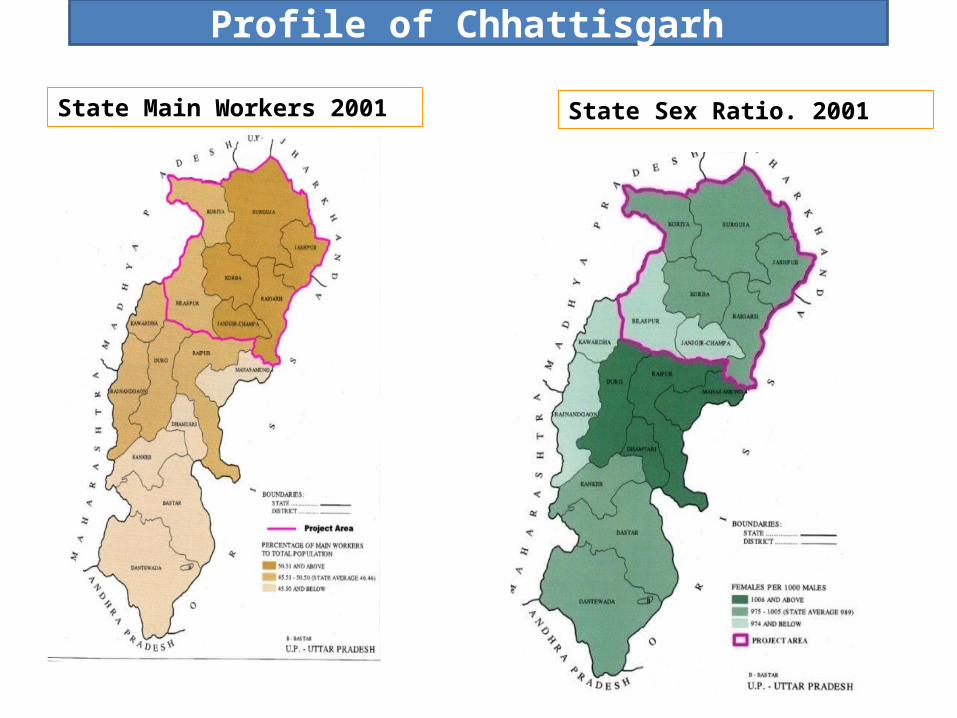
State Main Workers 2001 State Sex Ratio. 2001
Profile of Chhattisgarh

State Literacy Rate-2001
Profile of Chhattisgarh Agro Climatic Zones of the Chhattisgarh

AIM: To prepare the Regional Plan for development of Korba-Jangir-Champa-Raigarh-Bilaspur-Koriya-Ambikapur, Jashpur (Region) in Chhattisgarh for achieving overall balanced development in the Region.
Objectives :Develop a Regional Plan for the Korba-Jangir-Champa-Raigarh-Bilaspur-Koriya-Ambikapur,
Jashpur (Region)’ in Chhattisgarh.
Preparation of Infrastructure Development Plan to channelize the urban and economic growth.
Preparation of Techno-Feasibility Plan for Special Investment Zone
Identify and give Strategy to enhance the potential of the region
Enhance the development of Industry and Mining in the project area with conformity to the ecological and
land utilization aspect.
Detailed Area Development Plan of rapid growing parts of the project area.
Aim & objectives

Scope of Work
1. Preparation of Regional Plan• Broad regional delineation for the entire State
Demography of the region Socio-Economic characteristic of the region Industrial and mining setup in the region Agricultural areas of the region
• Delineation for the Proposed Region Review of the existing land use pattern Demographic and socio-economic attributes in the region Analysis the existing development pattern in the region Reconnaissance Survey of the project influence region for the identified resource based Region Collating requisite maps and information to prepare an update on the comprehensive baseline
condition of the region. • Assessment and future proposals should cover the following
Socio economic estimates for the influence region Future demographic estimates of the region Allocation of land use and Public Utilities Assessment of proposed transportation connectivity Assessment of industrial potential
2. Preparation of Techno Economic Feasibility Studies• Financial feasibility of identified projects• Institutional framework ad funding mechanism• Phasing of Development
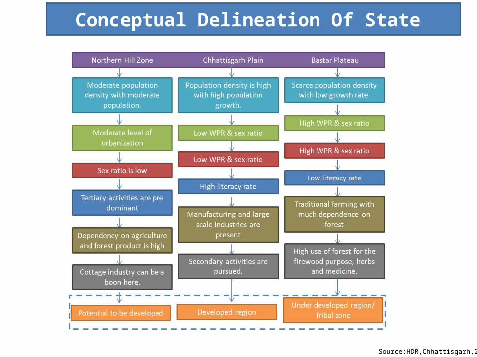
Conceptual Delineation Of State
Source:HDR,Chhattisgarh,2005

Delineation Of Project Region
Factors of Delineation
Formal Regions (Homogeneous)• Physiographic (Hilly land, Plain land, low land)• Vegetation Region (Forest, Grassland, Scrub land)• Watershed Region• Mineral Region• Climatic Region• Demographic Region• Economic Region (Spatial economic areas, agriculture region, industrial region)• Socio-Cultural region (Tribal areas, Indigenous lifestyle areas)
Functional Regions• City Region (Urban sprawl)• Hinterland of Economic Zone(Flow of commodities and people)• Transportation Connectivity and Accessibility

Northern part of Region – Koriya, Surguja, Jashpur
Key characteristics:Hilly terrainDense forest areaEcologically Sensitive
Development Potential:TourismHydroelectricity Generation
Southern part of Region –Bilaspur, Korba, Raigarh, Jangir-Champa
Key characteristics:Almost flat terrain, Low isolated hillsGood connectivity and Accessibility
Development Potential:Up gradation of Industrial efficiencyInvestment for mining sectorRoadmap for Infrastructure investment
Source: HDR,Chhattisgarh,2005
Delineation of the Project Region

Connectivity in the Region
High waysOther major RoadsBoundaryRail Way line
Two major national highways are passing through the study region.
1. NH 78 Connected from Madhya Pradesh(Katni) to Jharkhand(Ranchi)
2. NH 12 Connected from Madhya Pradesh(Jabalpur) to Orissa(Bhubaneswar)
3. NH 200 that links the capital of Raipur with the scenic spot of Chandikhol in Orissa.
4. A railway line passing from the area, Durg to Ambikapur , which is connecting the project region.
To Katni
To Ranchi
To Jabalpur
To Bhubaneswar

Sl No. Spatial unit Total Area (Ha) Population
PopulationUrbanization Level
Share of District to Region(%)
Share of District to State
(%)
Urban population
Urban population(%)
Sex RatioLiteracy
Rate
1 Bilaspur district 856885 1998355 22.46 9.59 486694 24.35 971 63.51
2 Jangir-champa district
446674 1317431 14.81 6.32 145319 11.03 998 65.94
3 Jashpur 645741 743160 8.35 3.56 34195 4.6 999 63.77
4 Korba district 576947 1011823 11.37 4.85 366963 36.26 964 61.71
5 Koriya district 597770 586327 6.59 2.81 174791 29.81 946 63.09
6 Raigarh district 652774 1265529 14.22 6.07 169456 13.39 994 70.16
7 Surguja district 1603440 1972094 22.17 9.46 137181 6.95 972 54.79
Total Region 5380231 8894719 42.69 1514599 17.02 977 63.28
Chhattishgarh state 13519100 20833803 4185747 20.12 990 65.12
Baseline Profile- Demographic
• Bilaspur with the largest population,19,98,355 and Koriya stands with lowest population.
• Jashpur has the highest sex ratio, 999 and Koriya with the lowest sex ratio, 946
• Korba, the powerhub of state has highest urbanization in the region followed by Koriya and Bilaspur
• Raigarh,known as education centre of Chhattisgarh has highest literacy rate i.e (70.16) while Surguja
has lowest.
Source: Census of India, 2001

Baseline Profile- Economic
Sr. No Spatial unit Total Workers % Total Workers % Total Non Workers % Primary Workers% Non Primary
Workers
1 Bilaspur district 857577 42.91 57.09 73.19 26.81
2Janjgir-Champa
district 575923 43.72 56.28 83.1 16.9
3 Jaspur district 397898 53.54 46.46 88.01 11.994 Korba district 431002 42.6 57.4 64.35 35.655 Koriya district 279826 47.73 52.27 72.07 27.936 Raigarh district 601564 47.53 52.47 79.81 20.197 Sarguja district 982041 49.8 50.2 86.86 13.14
Total Region 4125831 46.39 53.61 79.22 20.78Chhattishgarh State 9679871 46.46 53.54 76.47 23.53
Source: Census of India, 2001
•Main workers constitute 68.44% of the total workers in the region.
•Marginal worker is very low in the region reflects that the major proportion of workers is engaged for
substantial duration.
•Work force participation rate in the region is 46.39 in which 79.22% are primary workers which is higher
than the State primary workers (76.47%).
• Percentage of non workers is highest in the Bilaspur District while it is lowest in the Jashpur District
• Jashpur District is the lowest urbanization area but with the highest primary work, 88%.
•Korba District is highest urbanization area with highest worker in non primary sector.

Baseline Profile-Agriculture and Forest
Sr no. Spatial Unit Total Area (Ha)
Net Sown Area(ha)
% Net Sown Area
% of Forest area
1 Bilaspur district
856885 478994 55.9 30.24
2 Janjgir-Champa district
446674 323599 72.45 4.05
3 Jaspur district 645741 264361 40.94 37.72
4 Korba district 576947 143329 24.84 50.78
5 Koriya district 597770 119530 20 62.63
6 Raigarh district 652774 282400 43.26 35.87
7 Sarguja district 1603440 557151 34.75 45.61
Total Region 5380231 2169364 41.73 38.12Chhattishgarh state 13519100 5731677 42.41 41.32
• Surguja is having the (16,03440)l argest geographic area in the region.• Koriya is having 50 % of geographic area is forest area, and Janjgir-Champa has the lowest 4.1% area under
the forest cover• Jangir-Champa has higest net sown area and irrigated land While it is lowest in the Koriya District.
Korba & Koriya together constitute more than 50% of total forest area in the region
Source: Forest Survey of India Report,2005Source: Forest Survey of India

Baseline Profile- Mining
Major Mineral in the Region:
Lime stone, Cement plants, Aluminum, Lead &
silver, Iron ore, Gold.
Source: Census of India, 2001
Source: www.mapsofindia.com
Bauxite ore
DolomiteNo. District Minerals
1 Korea coals
2 Sarguja Coal,Bauxite
3 Jashpur Bauxite,Gypsum,Gold
4 Raigarh Limestone,coal
5 Korba coal,bauxite
6 Jangir-champa Limestone,Dolamite
7 Bilaspur
Dolamite,Limestone,Manganese,Bauxite,Iron
alloys,Gypsum

Baseline Profile- Water Bodies
• The northern part of the region catchments’ shares
the Gangetic Basin while southern part of the region
catchments’ share the Mahanadi Basin
• The Satpura Range and the Chota Nagpur Plateau
divide the Mahanadi River basin from the Gangetic
plain.
• This Mahanadi river basin, basically, forms the central
part of the state.
• The southern zone of Chhattisgarh includes a part of
the Deccan plateau and is served by the Godavari river
and its tributaries. Source: www.mapsofindia.com
Project Region
RiverWater Shed
Project Region

Baseline Profile-Tribes
Tribal people of Chhattisgarh constitute 31.75 % of the population.
Bilaspur
Raigarh
Surguja
Source: Census of India,2001
Sr No.
Spatial unitTotal
Population%Schedule
Tribe
1Bilaspur
district1998355 19.87
2Jangir-
champa district
1317431 11.62
3 Jashpur 743160 63.24
4Korba
district1011823 41.50
5Koriya district
586327 44.35
6Raigarh district
1265529 35.38
7Surguja district
1972094 54.60
Total Region 8894719 36.25Chhattishgarh state 20833803 31.76
Jashpur has the highest no. of ST population in the region followed by Surguja district

Methodology
STAGE 1 Spatial Temporal Analysis
Inception ReportComplexity of Spatial phenomenon
•Location•Distribution•Interaction
Activities
• Reconnaissance Survey•Consulting with Official• Preview of the area• Formulation of the Methodology• Secondary Data Collection
STAGE 2
Delineation of Tentatively Propose
Region (Maps and Report)
State Broad Regionalization
Regionalization within the Project Area
Activities
• Statistical Methods (Fixed Index, Cluster Index, Variable)• Identification of Target based region• Identification of Resource based region

STAGE 3
STAGE 4
Assessment of Existing Situation and Forecasts of Identified Region (Maps and Report)
Demographic Growth
Migration & livelihood
Urbanization Dynamics
Economic growth & Structural Shift
Infrastructure & Investment
Social composition
Natural resource & Land use
Transportation & connectivity
Activities
•Secondary Data Collection • Consultation with the line department•Compilation, interpretation explanation and analysis of data• Preparation of natural resource inventory and mapping of natural resources• Preparation of base map and land cover map
Ascertaining the Distribution of Development
Distinguish Heterogeneous Spatial Entities
Land Use Plan with present pattern and with primary future projections (Maps and Reports)
Demographic Forecasting
Economic & Occupational estimates
Environment and Land use assessment
Urbanization growth prediction
Inter sectoral growth
Infrastructure demand
Activities
• Allocation of land use and land cover• Identification of urban villages• Environment Suitability• Emerging transport corridor• Ecological threat zone

STAGE 5
Preliminary Regional Plan (Maps and Report)
Land Management Plan
Infrastructure Plan
Natural Resource Management
Activities
• Environmental Suitability Analysis• Scalogram• Land Potential Analysis• Land Capability Analysis• Identification of ecological threat zone• Future Urbanisable zone• Alternatives
STAGE 6 Preliminary Regional Plan (Maps and Report)
(Stakeholder Consultation 1)
STAGE 7Revised Regional Plan (Maps and Report)
Stakeholder Consultation 2
Draft Regional Plan (Maps and Report)STAGE 8
Stakeholder Consultation 3
Final Regional Plan (Maps and Report)STAGE 9
Stakeholder Consultation 4

STAGE 10
Preparation of concept Plan
Project Inventory
Techno-Economic Feasibility Plan
•Power Sector•Regional Connectivity•Water Supply
•Opting the proposed plan
•Identification of sector based project
•Prioritizing the project
•Phasing of project
•Cost of projects
•Funding cost
•Institutional setup
•Planning legislation
•Institutional mechanism
•Strategic Interventions
ActivitiesDraft Techno Economic Prefeasibility for Identified Projects (Maps and Report)
STAGE 11Final Techno Economic Pre-feasibility for Identified Projects (Maps and Report)
(Stakeholder Consultation 5)

Project Team Key professional - CEPT Key professional - CEPT
Sr. No Position Experience
1 Utpal Sharma- Team
Leader – Urban
& Regional Planning
expert
Team leader- Urban ®ional Planning expert
Post Graduate Diploma (Minimum Cost Housing), Post Graduate Diploma
(Urban and Regional Planning), fellow member of Institute of Town
Planners, India with projects on regional planning involving preparation of
regional development plans / Master Plans/ District level Development
Plans.
2 Shivanand Swamy Transport Planner Post Graduate Diploma (Planning), Masters in Economics and more than
20 years of experience in housing projects and land economics.
3 Shravan Acharya Geographer Planner Post Graduate in Urban & Regional Planning and basic qualification in Geography with over all 10 years of experience and at last 5 years experience of working on Regional Planning Projects.
4 Madhu Bharti-
Economist Planner
Economist and Regional Planner
Post Graduate Diploma (Human Settlement- Remote Sensing), Post
Graduate Diploma (Planning), M.A. in Economics more than 20 years of
experience on spatial land use projects.
5 Ashwani Kumar-
Environment Planner
Environment Planner Post-graduate in Environmental Sciences/ Environmental Engineering and
worked on projects involving mining and/or industrial developments at
regional levels and experience of more than 10 years conducting
Environment Impact assessment on large scale projects.
6 Saswat Bandhopadyay-
Infrastructure Expert
Infrastructure Planner Professional Masters (Urban Infrastructure Management), Masters in
Planning (Engineer Planner) with more than 10 years of experience on
Regional Infrastructure projects. Worked on regional level infrastructure
implementation of water supply and sanitation projects.
7 S.S Mehta Financial Expert/ Economist
Should be an MBA (Finance)/ Economist with 10 years experience in
market study, demand and supply assessment and project funding

Project Team
Sr. No Position Experience
1Ms. Anal Vaishnav -Chief Executive Officer
Post Graduate (Urban Planning ), Bachelor of Architect and 10 years experience in Urban & Regional Planning, Infrastructure Planning and Architecture.
2Jaydatt Vaishnav-Asst. General Manager (Design, Planning and Management)
Post Graduate (Housing), Bachelor of Architecture and more than 8 years experience in Urban Planning, Urban Infrastructure, Urban Design, Architecture, & Housing.
3Arjun Joshi-Manager (Design, Planning and Management)
Post Graduate (Urban and Regional Planning), Bachelor of Architecture and 7 years experience in Urban and Regional Planning, Transport and Infrastructure planning Architecture.
4 Ankur ChowdharyPost Graduate (Urban and Regional Planning), Bachelor of Architecture, Experience of working on Industrial Regional Planning
5 Raghu Ram BPost Graduate (Urban and Regional Planning), Bachelor in Planning and Urban and Regional Planning, Experience of working on Regional Planning and Master Plan
Key professionals - Urbanus Infrastructure Development (P) Ltd Key professionals - Urbanus Infrastructure Development (P) Ltd
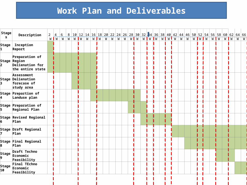
Stages Description 2 W
4 W
6 W
8 W
10W
12W
14W
16W
18W
20W
22W
24W
26W
28W
30W
32W
34W
36W
38W
40W
42W
44W
46W
50W
52W
54W
56W
58W
60W
62W
64W
66W
Stage 1 Inception Report
Stage 2Preparation of Region Delienation for the entire state
Stage 3Assessment Delienation forecase of study area
Stage 4Prepartion of Landuse plan
Stage 5Preparation of Regional Plan
Stage 6 Revised Regional Plan
Stage 7 Draft Regional Plan
Stage 8 Final Regional Plan
Stage 9Draft Techno Economic Feasibility
Stage 10
Final TEchno Economic Feasibility
Work Plan and Deliverables

Forest
Agriculture
Kosa silk weaving
Mining
Tourism
Educational Centre
Reconnaissance Survey

Potential:
Strategic location in the whole region
Have the potential to become a major transportation and Logistic
hub due to its location & connectivity.
Most profitable Railway zone of south eastern railway division
Also can be developed as cargo hub of state
Headquarter of South eastern coal filed limited and most profitable
subsidiary of coal in India
Also have a largest no. of cement factories
Issues:
Road connectivity yet to be revitalized with more emphasis on inter
and intra connectivity
Requirement of environment management system
Haphazard growth of urban centre
Reconnaissance Survey-Bilaspur
Entry to the Transport Nagar, on NH-200
Local market of Bilaspur
Source: Primary Survey, Urbanus And CRDC, CEPT

Potential:
Have a vast natural resources i.e thick vegetation coverage, waterfalls,
hills and diversified biome, can be developed as major tourist place of
India
Have a high grade coal reserves in Hasdeo river basin,may be
alternative to power hub of Korba
Issues:
Lack of proper infrastructure for tourism industry like hotels, resorts
Lack of unified tourism promotion and marketing programme
Amrit dhara,Baikunthpur
National Highway-79,
Source: Primary Survey, Urbanus And CRDC, CEPT
Reconnaissance Survey-Koriya
Ramdhara Water Fall Karma Dance

Potential:
Situated in the centre of Chhattisgarh are well connected by national
and states highways and is on Mumbai-Calcutta railway line and has
the Mahananadi in close proximity is attractive to industrial growth
Has the lowest forest land and higest irrigated land in the state has a
potential to develop as a horticulture centre and agriculture potential
zone.
Has also a potential to develop as a handicraft industries
Reconnaissance Survey- Jangir-Champa
Vishnu Mandir
Road from Champa to Jangir
Source: Primary Survey, Urbanus And CRDC, CEPTCocoons of Kosa SilkKosa Silk,Sarees

Reconnaissance Survey-Surguja
Local Market,Ambikapur
Tribal Market
Source: Primary Survey, Urbanus And CRDC, CEPT
Potential:
Surguja lies in the northen part of the state are more connected
with U.P,and Jharkhand
The recoverable reserves of bauxite in Surguja are 57.51 million
tonnes which is around 57% of total state reserves
Coal fields of Surguja district belongs to Gondwana land and of
good quality
41.67 % of toal geographical area are under cultivation and has
good potential to develop as horticulture centre
Issues:
Soils of Surguja are facing the problem of Bauxtisation and soil
erosion

Reconnaissance Survey-Raigarh
Forest Product in the city
Raigarh Railway station
Source: Primary Survey, Urbanus And CRDC, CEPT
Potential:
Known as the cultural capital of Chhattisgarh is well connected to
NH-200 and major state highways has transformed into a growing
industrial hub for steel
Raigarh is also well known for Dhokra casting and produce of two
types of silk namely Tasra silk and malburry silk and has a potential
to become a hub of cottage industries
Issues:
Facing the problem of excessive pollution created by sponge iron
industries and need to be monitored.

Reconnaissance Survey-Korba
Potential:
Known as power capital of Chhattisgarh is well connected with
national and state highways
Endowed with mineral resources like lime stone ,fireclay and
ingredients required for the power generation
The Thermal Power Plants (KSTPS, BCPP, CSEB East, CSEB West)
together generates 3650 MW of electricity.
Issues:
Korba is facing the acute problem arises due to fly ash caused by
power industry
The air quality of Korba is reached to the critical stage
Korba City
SECL, Korba
Source: Primary Survey, Urbanus And CRDC, CEPT

Reconnaissance Survey-Jashpur
Potential:
Jashpur lies on the north eastern part of the state has huge potential to
develop as the major tourist destinations
Issues:
Facing the problem of lack of infrastructure
Has the lowest urbanization level (4.6%) in the region and 88% of
population is primary workers dependent on agriculture and forest
produce
Bhringraj Waterfall
Ranidah WaterfallSnake park,TapkaraTribal LifestyleSource:jashpur.nic.in
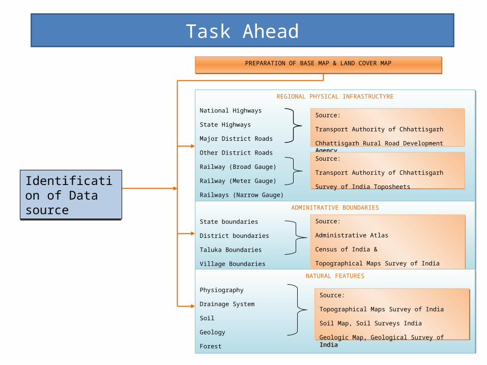
Task Ahead
PREPARATION OF BASE MAP & LAND COVER MAPPREPARATION OF BASE MAP & LAND COVER MAP
REGIONAL PHYSICAL INFRASTRUCTYRE
National Highways
State Highways
Major District Roads
Other District Roads
Railway (Broad Gauge)
Railway (Meter Gauge)
Railways (Narrow Gauge)
REGIONAL PHYSICAL INFRASTRUCTYRE
National Highways
State Highways
Major District Roads
Other District Roads
Railway (Broad Gauge)
Railway (Meter Gauge)
Railways (Narrow Gauge)
Source:
Transport Authority of Chhattisgarh
Chhattisgarh Rural Road Development Agency
Source:
Transport Authority of Chhattisgarh
Chhattisgarh Rural Road Development Agency
Source:
Transport Authority of Chhattisgarh
Survey of India Toposheets
Source:
Transport Authority of Chhattisgarh
Survey of India Toposheets
ADMINITRATIVE BOUNDARIES
State boundaries
District boundaries
Taluka Boundaries
Village Boundaries
ADMINITRATIVE BOUNDARIES
State boundaries
District boundaries
Taluka Boundaries
Village Boundaries
Source:
Administrative Atlas
Census of India &
Topographical Maps Survey of India
Source:
Administrative Atlas
Census of India &
Topographical Maps Survey of India
NATURAL FEATURES
Physiography
Drainage System
Soil
Geology
Forest
NATURAL FEATURES
Physiography
Drainage System
Soil
Geology
Forest
Source:
Topographical Maps Survey of India
Soil Map, Soil Surveys India
Geologic Map, Geological Survey of India
Source:
Topographical Maps Survey of India
Soil Map, Soil Surveys India
Geologic Map, Geological Survey of India
Identification of Data sourceIdentification of Data source

Task Ahead Cont…
Population Distribution, population Density and Household size, population Growth, Literacy Rate, Sex RatioPopulation Distribution, population Density and Household size, population Growth, Literacy Rate, Sex Ratio
Schedule Tribe, Schedule Caste, Work Force Participation Ratio, Employment Structure, Occupational Structure, Migration
Schedule Tribe, Schedule Caste, Work Force Participation Ratio, Employment Structure, Occupational Structure, Migration
Urban Status, Spatial Distribution of Urban settlement, Urban VillagesUrban Status, Spatial Distribution of Urban settlement, Urban Villages
Social infrastructure, Physical infrastructure, Scalogram IndexSocial infrastructure, Physical infrastructure, Scalogram Index
Road, Railways, Road Traffic, Air ConnectivityRoad, Railways, Road Traffic, Air Connectivity
Landuse under Agriculture, Net sown area, Fallow land, Cropping Intensity, Area under major crops & distribution, Irrigation
Landuse under Agriculture, Net sown area, Fallow land, Cropping Intensity, Area under major crops & distribution, Irrigation
Large Scale Industries, Medium Scale Industries, Small Scale Industries, Investment, MiningLarge Scale Industries, Medium Scale Industries, Small Scale Industries, Investment, Mining
DemographyDemography
Socio Economic Socio Economic
Urban Centres Urban Centres
Infrastructure Infrastructure
TransportationTransportation
AgricultureAgriculture
Industries & Mining\Industries & Mining\
Source: District Census Hand book of IndiaSource: District Census Hand book of India
Source: District Census Hand book of India, Census Migration tableSource: District Census Hand book of India, Census Migration table
Source: District Census Hand book of IndiaSource: District Census Hand book of India
Source: District Census Hand book of India, Department of Health & Family Welfare
Source: District Census Hand book of India, Department of Health & Family Welfare
Source: Public Works Department (PWD), Transport Authority, Traffic Census
Source: Public Works Department (PWD), Transport Authority, Traffic Census
Source: Directorate of AgricultureSource: Directorate of Agriculture
Source: Commerce and Industry Department, Directorate of Geology and Mining
Source: Commerce and Industry Department, Directorate of Geology and Mining
Statistical Data
Statistical Data

Task Ahead- Delineation of Tentatively Propose Region
Chapter 1: Synoptic view of the state.
Chapter 2: Conceptual delineation of the state.
• Categorization of the state in physiographic zones.
• Delineation of rapid population growth zone.
• Clustering of industrial and mining zone with typology.
• Economic diversified zone.• Biodiversity zone.• Urbanized zones
Chapter 3: Spatial integrity of spatial characteristics.
Chapter 4: Formal delineation of region within the project area.
Chapter 5: Schematic theme of the region.• Industrial corridor belt.• Fertile agriculture tract• Mining cluster• Cluster of urban and urban
villages.• Tribal belt and hilly areas.• Forest area
Chapter 6: Development Index in the region.
Chapter 7: Identification of progressive and potential areas in the region