References - Heritage - Heritage · integrated for training and ... supplying coal for two...
51
238 Coal Mining Heritage Study YNOC operation with the extinction of coal reserves was offset by the merging and subsequent transfer to YNEOC. Personnel employed at YNEOC were part of the much larger Yallourn Open Cut employee groups with whom they were fully integrated for training and promotional opportunities. The YNEOC has undergone extensive rehabilitation and erosion control works since the cessation of mining in 1988. Much of the mine site including the external overburden dump has been restored to pre-mining use as grazing land. Mine Infrastructure Features Remaining economically minable coal reserves. Rehabilitated landscape – leaving resumption of mining as feasible. Residual water storages for fire fighting and erosion mitigation. Site of roadside coal storage and outloading bin. References Brown, K et al ‘Yallourn North Extension Open Cut Interim Rehabilitation’, Rehabilitate Victoria, AusIMM, November 1992 Gloe, CS, Geological Report, No.1, SECV, 1956 Gloe, CS, Geology of Brown Coal Deposits, Monograph No.11, AusIMM, 1984 Herman, H, Brown Coals Of Victoria, 1922 Mineral Statistics, Mines Department, 1965 Rusden, GF, History of Yallourn, Yallourn North and Yallourn North Extension Open Cuts, July 1947 to June 1965, SECV, 1968 Vines, JA, A Technical History of Yallourn North and Yallourn North Extension Open Cuts, 1965 to 1988, SECV, 1989 Vines, JA, A History of the Loy Yang Mine: Its Origins and Development to May 1997, SECV, June 2000, p.356 Table 9.4/2 YNXOC Coal excavation, 1957 to 1988 (copy from Vines (1989), p.67).
Transcript of References - Heritage - Heritage · integrated for training and ... supplying coal for two...

238 Coal Mining Heritage Study
YNOC operation with the extinction of coal reserves was offset by the merging and subsequent transfer to YNEOC.
Personnel employed at YNEOC were part of the much larger Yallourn Open Cut employee groups with whom they were fully integrated for training and promotional opportunities.
The YNEOC has undergone extensive rehabilitation and erosion control works since the cessation of mining in 1988. Much of the mine site including the external overburden dump has been restored to pre-mining use as grazing land.
Mine Infrastructure Features
Remaining economically minable coal reserves.
Rehabilitated landscape – leaving resumption of mining as feasible.
Residual water storages for fi re fi ghting and erosion mitigation.
Site of roadside coal storage and outloading bin.
References
Brown, K et al ‘Yallourn North Extension Open Cut Interim Rehabilitation’, Rehabilitate Victoria, AusIMM, November 1992
Gloe, CS, Geological Report, No.1, SECV, 1956
Gloe, CS, Geology of Brown Coal Deposits, Monograph No.11, AusIMM, 1984
Herman, H, Brown Coals Of Victoria, 1922
Mineral Statistics, Mines Department, 1965
Rusden, GF, History of Yallourn, Yallourn North and Yallourn North Extension Open Cuts, July 1947 to June 1965, SECV, 1968
Vines, JA, A Technical History of Yallourn North and Yallourn North Extension Open Cuts, 1965 to 1988, SECV, 1989
Vines, JA, A History of the Loy Yang Mine: Its Origins and Development to May 1997, SECV, June 2000, p.356
Table 9.4/2 YNXOC Coal excavation, 1957 to 1988 (copy from Vines (1989), p.67).

Coal Mining Heritage Study – Mine Sites Identifi cation 239
9.5 Morwell Open Cut
Map Reference: 8121-1-2 Morwell Zone 55Open Cut 4470, 57860
Municipality: City of Latrobe
Land Use/Status: Private
Site History
In 1936, Jan Klitzing, a German consultant to the SECV, recommended opening a new open cut south of Yallourn to provide increased reliability of coal supply to the Yallourn Power Station and Briquetting Plant and to provide for future demand.460 Reliability from the Yallourn Open Cut had previously suffered due to fl ood and fi re. Klitzing’s recommendation was not adopted at the time, with the SECV allocating funds for additional hydro-power at Kiewa in 1938 and from 1941 for Newport Power Station burning black coal.
In July 1941, an Investigatory Committee on Utilisation of Brown Coal for Essential Services established by the State Government during a prolonged period of hard fuel shortages recommended that briquetting production (all at that time by the SECV at Yallourn) be increased from about 0.4 million tons per year to 1.2 million tons per year to meet existing demand with further increase to 1.7 million tons per year by about 1960. This proposed output did not include provision for replacement of existing coal usage. In August 1941, the SECV Engineer-in-Charge Coal Supply (R. J McKay) submitted a report ‘Yallourn Brown Coal for Essential Services’, taking into account the continuing increasing demand for electricity as well as for hard fuel. He submitted that ‘there are sound reasons for developing another open cut – the work of investigation should be commenced as early as possible’.461
The outcome of these recommendations was that the SECV undertook an extensive drilling program of the brown coal resource in Gippsland and submitted several reports on the selection of a new open cut location. On 13 July 1948, the State Government passed legislation approving a SECV recommendation for an Open Cut and Briquetting Works at the Maryvale South site immediately south of the Morwell township. The nomenclature ‘Morwell Briquetting Project’ was adopted. The enabling legislation defi ned the project as
supplying coal for two briquette factory units with a combined output of 1.3 million tons per annum of briquettes, noting that there were suffi cient coal reserves available in the approved open cut site for a further output of 1.3 million tons per annum of briquettes462. The coal in the Maryvale South site was from an older coal seam to that being mined at Yallourn, was of lower moisture content but higher sulphur and ash content.
In the selection of the Maryvale South location for the briquetting project, the SECV had nominated the Loy Yang area at the south of the Traralgon township site as being more favourable for an electricity generation site, and that the Loy Yang coal resource as well as the coal resource at a Maryvale North location on the north of Morwell township be reserved for future use by the SECV for power generation463.
At June 1948, it was noted by the Minister for Electrical Undertakings in introducing the enabling act to Parliament that the SECV had been requested by Government in December 1946 to proceed from that time with procurement of open cut equipment which could be used at Yallourn Open Cut if formal legislation for the Morwell Briquetting Project was delayed.464
The development plan proposed by the SECV at 1948 for the 2.6 million tons per annum briquetting output was based on rail mounted ladder dredgers on four operating benches. One dredger was to be on overburden removal with disposal via a rail system to a rail mounted spreader on an external dump. Five dredgers were to be on coal excavation loading to rail tracks with delivery from ditch bunkers on the eastern batters to raw coal bunkers adjacent to the briquette factories. Three of the coal dredgers were planned to be deep digging and two to be high digging ladder dredgers.465 This plant complex was similar to that in use at Yallourn in the late 1930s and was advocated by senior YOC personnel on the basis of Yallourn experience to the early 1940s.
In 1946, as soon as practical after World War II, a group of senior SECV engineers visited Germany and evaluated trends in German Open Cut practice. Although orders were placed by the SECV in 1947 for three rail mounted bucket chain (ladder) dredgers, consideration was being given to subsequent dredgers for the Yallourn and Morwell Open Cuts to be crawler mounted bucket wheel machines.
Site excavation at the Morwell project commenced by contract on 11 April 1949 on drainage, ramp and road access, water supply, worker accommodation and other infrastructure for

240 Coal Mining Heritage Study
the open cut. By June 1950, work had commenced on the interconnecting SECV 90 cm gauge railway between Morwell and Yallourn Open Cuts, a vital provision for initial transfer of overburden and coal from Morwell and for future reliability of coal supplies (Drawing 9.4/5). In early 1950, orders were placed for a bucket wheel dredger (SECV Number 21) and a rail mounted overburden spreader (SECV Number 3; Photo 9.5/4), a fi ve cubic yard walking dragline and a wide range of electric locos, rail trucks and ancillary rail equipment required for service from 1951 to1952.466
However in August 1951, the Commonwealth Government imposed severe restrictions on funds for development works throughout Australia. Plant procurement for Morwell Project was delayed and site construction work almost completely postponed until September 1954.
(Number 21 dredger travelled off its erection site at Morwell on 16 November 1953 for travel and digging trials. Total excavation time was about one hour of overcasting before the dredger travelled back for modifi cations and completion of outstanding contractual items.) Number 21 dredger came into service on overburden excavation with trials in September/October 1955 delivering over the Interconnecting Railway to the YOC internal dump and also to Number Three Spreader at the MOC external dump.467
Coal excavation commenced in November 1955 over a period of three consecutive day shifts with Number 21 dredger excavating this coal from the overburden face and delivering this over the ICR to Number Three ditch bunker at Yallourn. Regular coal deliveries on this route from Number 21 dredger commenced in December 1955. The rail mounted Number 20 ladder dredger (Photos 9.5/3 A and B) came into service on 16 July 1956, working additionally to Number 21 dredger on overburden removal as well as development of the fi rst coalface. For the 1956/57 year before coal deliveries commenced to the Morwell ditch bunker, approximately 50,000 tons of coal was delivered over the ICR to Yallourn and about 1.5 million cubic yards of overburden excavated by dredgers 20 and 21.468
In late 1957, with forecasts of substantially increased coal demand on MOC, the long term development plan for MOC was changed to provide for coal and overburden transport to be by belt conveyor instead of by rail and for excavators to be crawler mounted bucket wheel dredgers. This change was to apply to future plant orders as the open cut developed in
depth and to replacement of rail plant when justifi ed. The new plan envisaged transfer of rolling stock to the expanding rail delivery systems in YOC.469
In November 1958, coal supplies commenced from MOC to Morwell Power Station.470
In August 1959, coal supplies commenced from MOC to the Morwell Briquette Factory which had its fi rst test runs on 9 September 1959 with briquette output for November at 16,583 tons. On 8 December 1959, the fi rst deliveries of briquettes from the MBF to the Gas and Fuel Plant at Morwell commenced.471 However it was found that briquettes from Morwell Coal were not as good in weathering, and in furnace fouling as those made from the cleaner and lower ash content coal from YOC. Although many subsequent trials of briquetting from MOC coal were carried out subsequently, selected briquetting coal (low silica, low ash, low woody content, and light brown lithotype) from YOC was used continuously at the MBF through to the late 1990s when the ICR was taken out of service. Thereafter road haulage of coal from YOC and later
Photos 9.5/1A–B (left to right) MOC: Drilling rigs 1948 (from Vines, (1996), p.132).
Photo 9.5/2 MOC: Initial excavation area, 1950 (from Vines, (1996), p. 45A).
Coal Mining Heritage Study – Mine Sites Identifi cation 241
from Loy Yang Open Cut as well as minor supplies from MOC was used as demand for briquettes decreased.472
At 1959, the Government on the recommendation of the SECV gave approval for a power station of six 200 MW units be built at Hazelwood fuelled by MOC coal. Approval was given in May 1965 for a further two 200 million watt units at Hazelwood Power Station.473 The generating capacity at Morwell Power Station was also increased to 170 million watts. The increased coal demand on MOC by these increases in generating plant more than offset the reduction due to transfer of coal supplies to the MBF from MOC to YOC coal, and the cancellation of the installation of two additional briquette factories originally ordered in December 1950.474
Long term plans for development of MOC were modifi ed extensively to increase excavation and transport plant capacity to meet the forecasted higher coal demand. Rail haulage of coal and overburden was progressively changed to conveyor transport. The ICR was retained for briquetting coal deliveries to Morwell, and for emergency or supplementary coal transfer from MOC to Yallourn and Yallourn W Power Stations.
Coal supply to Hazelwood Power Station commenced in July 1964. The eighth unit of HPS came into service in late 1970. Coal output met demand of 12.28 million tons per annum in 1969/70, rising progressively with demand to 16.02 million tonnes per annum in 1976/77.475
Number 21 bucket wheel dredger proved unsuitable for overburden excavation and uneconomical for coal winning, due to its low output capacity. It was taken out of service in 1982 after 36 years of service excavating 1.92 million cubic metres of overburden and 35.40 million tonnes of coal. This dredger remains as a heritage item on display to the public off the roadside near the former entrance to the Morwell Open Cut at the Power Works Visitors Centre.476
Number Three bucket wheel dredger was also a small capacity machine. At MOC it excavated 0.073 million cubic metres of overburden and 13.51 million tones of coal between 1959 and 1983. At YOC it excavated 12.82 million tons of coal between 1950 and 1959, and 2.07 million tonnes between 1983 and 1984. It was withdrawn from service in 1984 after 34 years service, after which the bucket wheel assembly was preserved as a heritage item on display at the Power Works Visitors Site at Morwell and the remainder of the dredger retained as spare equipment or sold for scrap.
Number 20 bucket chain dredger came into commercial service on 16 July 1956 as a rail mounted overburden excavator loading trains delivering to Number Three spreader on an external dump (Photos 9.5/3 A and B). It excavated 19.77 million cubic metres of overburden and 0.86 million tons of coal in its 13 year life from 1957 to 1970. It was taken out of service after its completion of overburden removal in the MOC East Field.
Number 19 bucket chain ‘gleisraupen’ crawler-mounted dredger came into commercial operation on 10 October 1960 after extensive modifi cations to convert a German design from rail to conveyor out-loading (Photo 9.5/5). This machine went into service as the excavator at the lowest operating level in the open cut being used for developing the open cut to depth.477 It had a low output capacity particularly when digging on a deep face. It excavated 40.53 million tonnes of coal to its retirement in 1990. By that time the mine had been opened up to the full depth of the Morwell Number One coal seam. A bucket wheel dredger took over its role of extending the mine on the bottom operating level by excavating on the bottom side of its face conveyor. Number 19 dredger was cannibalised for spares and its remains sold for scrap.478
Other excavators of higher capacity than the plant ordered for the initial ‘briquetting project’ were progressively brought into service. These later machines were all bucket wheel excavators.
Number Nine Dredger (Photo 9.5/8) went into service on coal excavation on 18 May 1964.479
Number Ten Dredger went into service on coal excavation in February 1970 and transferred to overburden removal in May 1970 at the commencement of overburden transport by conveyors to the Tripper/Stacker TS2480.
Photos 9.5/3A–B (top to bottom) MOC: 20 Dredger on overburden removal (from Vines, (1996), p.121).

242 Coal Mining Heritage Study
Number 11 Dredger (Photo 9.5/9) came into service on 13 July 1970 and was used mainly as a coal winning machine but at times substituting for Number Ten dredger on overburden removal.481
Number 24 Dredger, a compact bucket wheel excavator, commissioned at YOC in July 1984 was transferred to MOC in an emergency when Number Ten and Number 11 Dredgers had coincident major breakdowns. Number 24 dredger operations at MOC commenced on 25 June 1987. It stayed at MOC excavating 13.67 million tonnes of coal to March 1995 when it was mothballed for sale or emergency recall at either open cut.482 The latter eventuality occurred when dredger Number 24 was recalled to service in MOC, and at 2005 continues to be used in a mobile reserve capacity covering
breakdown of other dredgers or for special development excavation.
Number 25 Dredger (Photos 9.5/11 A and B) – a compact bucket wheel excavator of somewhat higher capacity than 24 Dredger – came into service on 13 December 1989.483
At 2005, Number Nine, Ten, 11 and 25 dredgers remained in service intended for continued operation in the new West Field. These dredgers were all interchangeable being of relatively similar output capacity and excavating reach, albeit that Number Nine Dredger was not favoured for overburden removal and Number 25 Dredger had a somewhat lesser reach.
With the progressive replacement of the rail transport by conveyor systems from about 1960, the open cut was developed in depth and extension predominantly by parallel
Drawing 9.5/1 Mining/Exploration Leases in Morwell River Valley at the West of Morwell circa 1910.
Photo 9.5/4 MOC: Number Three Spreader (from Vines, (1996), p.127).
Photo 9.5/5 MOC: Number 19 Dredger (from Vines, (1996), Drawing 6.6/2, p.90).
Photo 9.5/6 MOC: View at June 1952 (from Vines, (1996), p.116).

Coal Mining Heritage Study – Mine Sites Identifi cation 243
moves of four face conveyors as trunk conveyors extended and pivoted into new ‘fi elds’. At various periods of the development, there were two top side excavation faces and one bottom side accessed by ramp systems at or near the tail end of each conveyor. At various periods two excavators were allocated to the one face conveyor. Two mobile slew conveyors were available for allocation to provide greater reach and fl exibility for a dredger.
A signifi cant feature of the mine development was the need for extensive dewatering of the aquifers below the Morwell Number One and Number Two coal seams, to limit earth movement of the mine batter systems and heave of the fl oor of the open cut. An extensive monitoring system was employed to measure movement of batters, benches and earth surface while aiming for minimum lowering of aquifer pressures to achieve safety from excessive movements. The aquifer water extracted was utilised in fi re protection but predominantly was pumped as ‘clean water’ to the Hazelwood Power Station Cooling Pond to improve water quality therein and reduce the usage of domestic water supply for Power Station cooling water.484
Enhancement of community infrastructure for water supply storages and reticulation, for deviations and upgrading of the regional roads and highways, for housing and local service industries and for education through to tertiary level was signifi cant from 1950 as an outcome of initiation of the Morwell Project and its continuation as a major electricity generating complex based on the Morwell Open Cut.
On 1 January 1994, the SECV was disaggregated. The new public authority responsible to Government for management of coal mines and electricity generation was named Generation Victoria. On 1 February 1995, Hazelwood Power Corporation was established by Government to manage the Morwell Open Cut and Hazelwood Power Station as a public authority. On 9 August 1996, the assets of Hazelwood Power (including Morwell Open Cut) were sold by Government to a private consortium with National Power from England as the majority shareholder.485
The corporate rearrangements did not lead to signifi cant change in the development proposals for Morwell Open Cut except that the new owners undertook repairs at Hazelwood
Drawing 9.5/2 Morwell Project Proposed Layout at 1950 (from the Mining and Geological Journal, March 1956).

244 Coal Mining Heritage Study
Power Station to return this station to full operation with eight units resulting in increased demand for fuel.
In August 2000, Hazelwood Power announced details of the Hazelwood West project involving continued development of the Morwell Open Cut by extension of the existing mine at the south, and then westward with site works commencing in 2001 within the existing mining licence area.486 This was the extension depicted on previous long term plans by the SECV.
In November 2000, International Power now owned 91.84 per cent of the Hazelwood Power Station and Morwell Open Cut complex having purchased 19.9 per cent previously owned by Scottish Power. The Commonwealth Bank retained the remaining 8.16 per cent of the ownership. This ownership structure remained at June 2005.487
In April 2001, the fi rst level of the internal dump for overburden disposal was completed after some three years of operation covering about 54 hectares to a depth of up to 28 metres. Relocation of the Tripper Stacker (TS2) and two conveyors to commence a second level dump was then undertaken.488
In July 2001, a contract was let for archaeological fi eldwork and interpretation of cultural heritage aspects in the proposed Hazelwood West Field. This work involved detailed inspections before and during overburden excavation of old homestead sites. Artefacts were retrieved from Koorie sites, classifi ed and deposited with the Morwell Koorie Co-operative Centre. These archaeological studies were to remain as a continuing feature of the West Field mining operation.489
For the 2001 calendar year, 19.77 million tones of coal was excavated and 12,173 Gigawatt Hours of electricity generated
Drawing 9.5/3 MOC Proposed Excavator Allocation at 1945 (from Three Decades, 1949, p.142).
Drawing 9.5/4 MOC/YOC: Interconnecting Railway Layout from 1956 (from Vines, (1996), p.79).
Photo 9.5/7 MOC: Three dredgers loading one conveyor. Copyright State Electricity Commission of Victoria.
Photo 9.5/8 MOC: Number Nine Dredger with eight units of Hazelwood Power Station in service. Copyright State Electricity Commission of Victoria.

Coal Mining Heritage Study – Mine Sites Identifi cation 245
Drawing 9.5/6 MOC: 1965 proposal for allocation of dredgers, with only one ladder dredger (from Vines, (1996), p.175).
Drawing 9.5/5 MOC/YOC: 1949 Proposal for introduction of bucket wheel dredgers (from Herman, (1952), Fig.185, p.190A).
Photo 9.5/9 MOC: Number 11 Dredger (from Vines, (1996), p.186).
246 Coal Mining Heritage Study
(over 11,000 GWh sent out). This was a record annual coal output for MOC. Over four million cubic metres of overburden had been stripped from the West Field by mobile plant and placed in a levee bank on the south side of the West Field and on earth ramps for the site of coal conveyors in the West Field. Sixteen 50 tonne capacity rigid frame trucks and seventeen 40 tonne articulated trucks were used on overburden haulage and placement. Removal and placement of 6.1 million cubic metres of overburden was expected in the 2003 year.490
In May 2002, a contract was let for design and construction of four conveyor systems to be used in the Hazelwood West Field, using components from the existing systems in the South East Field where feasible. These four systems were required to be in service progressively from September 2003 to 2006.491
In October 2002, the owners of the Power Station and Mine Complex changed the name of the controlling entity to International Power Hazelwood (IPRH). For 2003, only 2.8 million cubic metres of overburden remained to be excavated in the South East Field.492
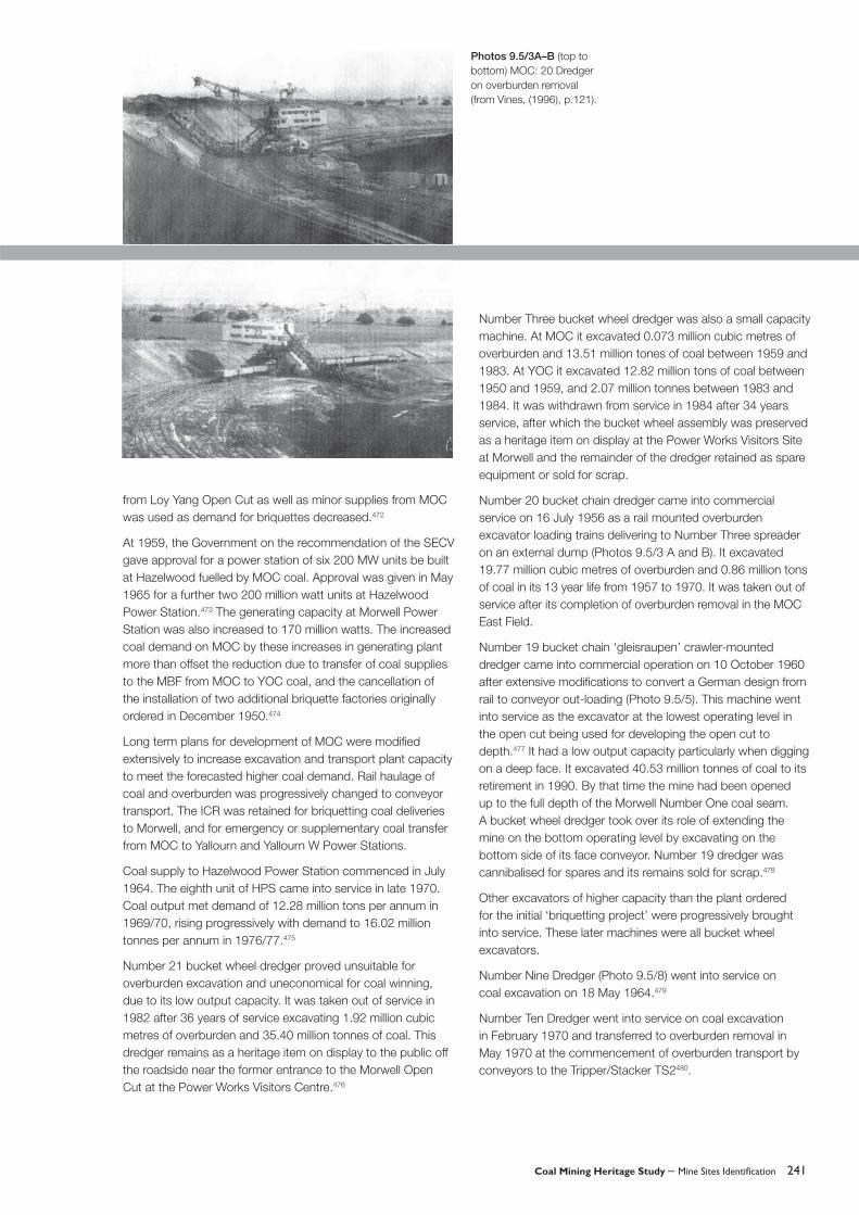
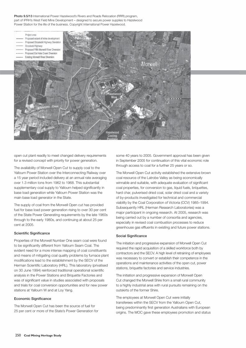
In May 2003, the Hazelwood West Field Development was given Major Project Facilitation Status by the Commonwealth Government. On the basis that the South East Field coal resource would be fully excavated by 2009, Stage 1 of the proposed development was approved for commencement of coal excavation later in 2003 within the existing coal mining licence boundary. However the proposal submitted by IPRH, including provision for coal supply to 2025, involved a deviation over a length of about seven kilometres of the previous diversion of the Morwell River, deviations of two creeks, relocation of the Strzelecki Highway and Brodribb Road, all to provide for extension of the mine via parallel movements of dredger operating faces through the West Field (Drawing 9.5/13). This proposal involved a logical modifi cation of the mining licence boundary which had originally been arbitrarily defi ned on land occupation boundaries rather than on a rational mining plan appropriate to the existing dredgers in use by IPRH. The IPRH proposal offered an exchange of coal bearing land of 110 million tonnes within the existing licence area for 92 million tonnes outside the existing licence area.493
In July 2003, IPRH submitted an Environmental Effects Statement (EES) for public comment and subsequently was engaged in a process of public and government hearings on provisions for environmental protection, including mitigation of greenhouse gas emissions from Hazelwood Power Station. At April 2005, after extensive discussions and modifi cations or additional commitments by IPRH, an Independent Panel established by the Government recommended approval of the latest IPRH proposals as ‘the most economical alternative for the supply of base load electricity to Victoria and the National Electricity Market’, and ‘as an appropriate use of the Gippsland brown coal resource’. Government response to the Panel’s recommendations and formulation of commitments by IPRH were still awaited at September 2005. In the meantime from 2004, IPRH had been involved in land purchases to gain ownership of land required for mining and for infrastructure deviations.494
Dredger Number 10 completed overburden removal in the South East Field in July 2003. The fi rst coal from the West Field was delivered in February 2004. The second coal system
Drawing 9.5/7 MOC: 1978 Morwell River diversion to access southern and western coal resources (from Vines, (1996), p. 231).
Photo 9.5/10 MOC: View at 1980 (from Vines, (1996), p.262).
Coal Mining Heritage Study – Mine Sites Identifi cation 247
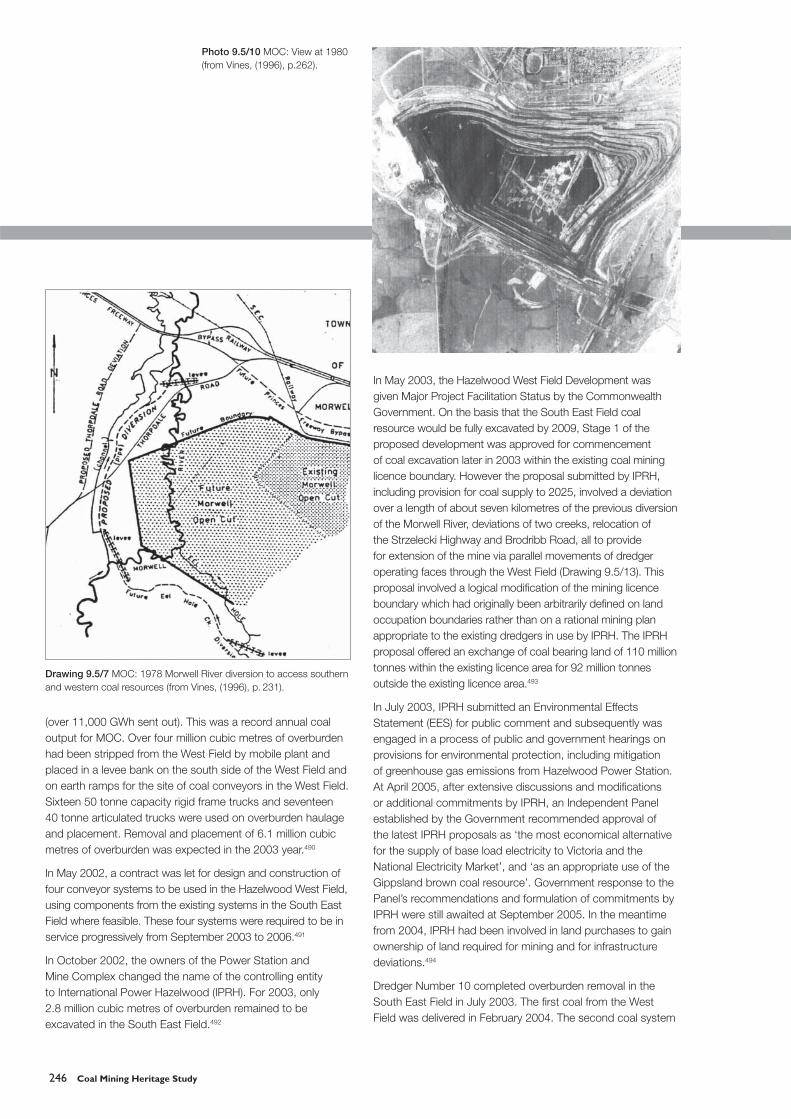
Drawing 9.5/8 MOC: Conveyor systems and dredger locations at August 1981 (from Vines, (1996), p. 258).
Drawing 9.5/9 MOC: Total accessible coal reserves at 1990, without a further river diversion (from Vines, (1996), p.309).

248 Coal Mining Heritage Study
in the West Field commenced operation in November 2004. The third system was expected in service by September 2005. The extensive use of mobile plant to open up the West Field eliminated the need for overburden removal by dredger prior to the initial coal excavation and reduced the overburden to coal requirements in the early years of excavation in the West Field. Hence, Dredger Number 25 was allocated the overburden removal and reserve coal excavator task commencing in June 2005. Numbers 9, 10, and 11 Dredgers were allocated to coal excavation in the West Field.495 Dredger 24 also remained in service for substitution for any of the other dredgers or for special operations.
Drawing 9.5/10 MOC: Conveyor systems and dredger locations at April 1995 (from Vines, (1996), p. 360B).
Photos 9.5/11A–B MOC: Number 25 Dredger and view of open cut at 1989 (from Vines, (1996), p. 301).

Coal Mining Heritage Study – Mine Sites Identifi cation 249
In January 2004, a major fi re in the Morwell Briquette Works owned by HRL and operated as Energy Brix lead to temporary cessation of briquette manufacture. A reduction of about 5 per cent of Morwell Open Cut output resulted. The small Morwell Power Station continued to be operated. Hazelwood and Loy Yang A Power Stations now had to fi nd alternative fuels for start up and combustion stability. In the short term supplies of black coal were accessed from NSW and Queensland while longer term options were considered. At 2005, the Morwell
Briquette factory had been restored to part operation by MECRUS on lease from HRL. At that stage, Morwell Power Station ran on MOC coal and MBF used Loy Yang coal.
Assessment of Heritage Signifi cance
Historical Signifi cance
The original concept of the Morwell Briquetting Complex was a major post war initiative to challenge the virtual monopoly exercised by NSW coal exporters to meet the increasing demand for hard fuels in Victoria.
Commencement of the Morwell Open Cut based on the original concept offered the opportunity to adapt the initial
Table 9.5/1 MOC: Annual coal outputs, 1956 to 1995 (from Vines, (1996), Table 7.5/3, p.109).
Photo 9.5/12 MOC: View at 1992 (from Vines, (1996), p. 323).
250 Coal Mining Heritage Study
open cut plant readily to meet changed delivery requirements for a revised concept with priority for power generation.
The availability of Morwell Open Cut to supply coal to the Yallourn Power Station over the Interconnecting Railway over a 15 year period included delivery at an annual rate averaging over 1.3 million tons from 1962 to 1968. This substantial supplementary coal supply to Yallourn helped signifi cantly in base load generation while Yallourn Power Station was the main base load generator in the State.
The supply of coal from the Morwell Open cut has provided fuel for base load power generation rising to over 30 per cent of the State Power Generating requirements by the late 1960s through to the early 1980s, and continuing at about 25 per cent at 2005.
Scientifi c Signifi cance
Properties of the Morwell Number One seam coal were found to be signifi cantly different from Yallourn Seam Coal. The evident need for a more intense mapping of coal constituents and means of mitigating coal quality problems by furnace plant modifi cations lead to the establishment by the SECV of the Herman Scientifi c Laboratory (HRL). This laboratory (privatised on 30 June 1994) reinforced traditional operational scientifi c analysis in the Power Stations and Briquette Factories and was of signifi cant value in studies associated with proposals and trials for coal conversion opportunities and for new power stations at Yallourn W and at Loy Yang.
Economic Signifi cance
The Morwell Open Cut has been the source of fuel for 25 per cent or more of the State’s Power Generation for
some 40 years to 2005. Government approval has been given in September 2005 for continuation of this vital economic role through access to coal for a further 25 years or so.
The Morwell Open Cut activity established the extensive brown coal resource of the Latrobe Valley as being economically winnable and suitable, with adequate evaluation of signifi cant coal properties, for conversion to gas, liquid fuels, briquettes, hard char, pulverised dried coal, solar dried coal and a variety of by-products investigated for technical and commercial viability by the Coal Corporation of Victoria (CCV) 1985–1994. Subsequently HRL (Herman Research Laboratories) was a major participant in ongoing research. At 2005, research was being carried out by a number of consortia and agencies, especially in revised coal combustion processes to reduce greenhouse gas effl uents in existing and future power stations.
Social Signifi cance
The initiation and progressive expansion of Morwell Open Cut required the rapid acquisition of a skilled workforce both by contractors and the SECV. A high level of retraining of employees was necessary to convert or establish their competence in the operations and maintenance activities of the open cut, power stations, briquette factories and service industries.
The initiation and progressive expansion of Morwell Open Cut changed the Morwell Shire from a small rural community to a highly industrial area with rural pursuits remaining on the outskirts of the former Shire.
The employees at Morwell Open Cut were initially transferees within the SECV from the Yallourn Open Cut, being predominantly fi rst generation Australians with European origins. The MOC gave these employees promotion and status
Photo 9.5/13 International Power Hazelwood’s Rivers and Roads Relocation (RRR) program, part of IPRH’s West Field Mine Development – designed to secure power supplies to Hazelwood Power Station for the life of the business. Copyright International Power Hazelwood.

Coal Mining Heritage Study – Mine Sites Identifi cation 251
improvement. Subsequent waves of employees were largely new migrants engaged in their fi rst employment in Australia.
Although the early workers on the MOC site were predominantly construction workers housed in temporary hostels on the outskirts of the town, a substantial public housing and infrastructure program matched the progressive increase in the workforce numbers such that ethnicity was not a problem in the harmonious growth of the new community. A new township of Churchill was established as a planned residential town in the early 1960s to provide housing stock for the introduction of new employees and for the expected demise of the Yallourn Township with its 4,500 residents.
Mine Infrastructure Features
Display at Power Works, Visitors Centre Morwell.
External overburden dump restoration.
Hazelwood Cooling Pond.
Morwell River Diversion Number Six.
Interconnecting Railway track and bridges.
Buckley’s Reservoir.
References
Discovery, Victorian Department of Primary Industry, February 2003
Herman, H, Brown Coal, SECV, 1952
Jumbunna, International Power Hazelwood, August 2000, November 2000, April 2001, July 2001, September 2001, March 2002, May 2002, June 2002, October 2002, January 2003, March 2003
‘Latrobe Valley Brown Coal Resources’, Proceedings No.194, AusIMM 1960. Papers by: Stewart, EDJ; Gloe, CS; Rodgers, HCG; and Alexander, JMA.
McKay, RJ, History of the Development of the Open Cut Workings at Yallourn, SECV, 1950
Vines, JA, A History of the Morwell Open Cut, Generation Victoria, 1996
9.6 Loy Yang Open Cut
Map Reference: 8221-4-3 Traralgon Zone 55Open Cut 4618, 57670
Municipality: Shire of Latrobe
Land Use/Status: Private
Site History
It is probable that the existence of brown coal deposits at Loy Yang in the Latrobe Valley was known or at least inferred from other brown coal discoveries in the Gippsland area by 1873. In 1875, lignite (brown coal) was reported offi cially as having been found at Traralgon.496 In 1876, the Mining Registrar at Traralgon reported: ‘There are several parties prospecting for coal, outcrops of which are to be found south of the Gippsland Railway’497. Specifi c reference to exploration for coal at Loy Yang appears to have fi rst occurred in 1889.498 The extent of identifi cation at 1890 of the coal resource in the Western Latrobe Valley as far east as Traralgon is shown in Drawing 9.6/1.499
Drilling to ascertain the geology and extent of the coal at Loy Yang and Traralgon was undertaken by the Mines Department between 1917 and 1922500 when Mines Department Loy Yang Bores 1 to 61 were drilled. However, the knowledge gained was not available in time for Loy Yang to be given detailed consideration as an alternative to the proposals coming to fruition by 1915 to develop the Yallourn Coal Field.
No further drilling to investigate the Loy Yang resource occurred until Bore Number 62 was drilled on 8 December 1943.501 In 1942, the SECV established a Brown Coal Investigation Section to undertake drilling and coal seam evaluation for assessment in selection of a new mining area to provide coal for a briquetting project. An essential feature of this concept was to have a coal transport connection from the new project to the Yallourn Power and Briquetting Complex as an emergency and supplementary fuel source for those economically vital works. In outcome, the Loy Yang coalfi eld was one of four sites selected for detailed consideration. However, it was the Maryvale South site that was recommended to Government in December 1946. The Maryvale South site was approved by Government in July 1948 as the Morwell Briquetting

252 Coal Mining Heritage Study
Project. A major factor in the preference for the Maryvale South site was its location closer to Yallourn than the Loy Yang site, with its coal transport interconnection being more economical and less intrusive on the local community infrastructure. However an associated recommendation by the mining consultant John Bridge in 1945 was that the Loy Yang site be resumed ‘to provide for its utilisation as a source of fuel for an additional power station’.
The subsequent addition of the Hazelwood Power Station based on fuel from the Morwell Open Cut, together with the extension of Yallourn Power Station and the provision of the Yallourn W power station, both of the latter based on fuel from Yallourn Open Cut, delayed the commencement of an open cut at Loy Yang. Also, the advent of natural gas supplies from Bass Strait in December 1969 lead to the SECV gaining Government approval for a two by 500 megawatt intermediate load power station at Newport. Although subsequently only one 500 megawatt unit was installed at Newport due to environmental concerns, gas turbines with a total 500 megawatt capacity were installed at Jeeralang near Hazelwood.
From the early 1960s, design concepts were being developed within the SECV for a Loy Yang base load power station based on the Loy Yang coal resource. In 1949, an Interim Development Order was placed limiting land price speculation in the Loy Yang area. From 1967 the SECV undertook land purchase in the Loy Yang area (Drawing 9.6/2).502
‘Legislation was passed on 23 November 1976 enabling the SECV to provide for the construction of a 4000 megawatt power generating project with coal supply from a new open cut at Loy Yang.’503
Until 1977, the site had been subject to visits by drilling crews, surveyors, engineers and geologists. On 19 January 1977, the fi rst contract was let for site works.504
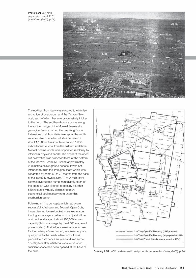
The Loy Yang Open Cut is situated about seven kilometres south east of the centre of Traralgon township. The potential for an open cut site at Loy Yang was identifi ed earlier than 1922.505 The specifi c site selected for coal supply from an open cut adjacent to a 4000 megawatt power station site was in a large shallow basin located between Traralgon Creek on the west and Sheepwash Creek on the east.
Drawing 9.6/1 LYOC Geological Plans and Sections (from Vines, (2000), p. 64).
Coal Mining Heritage Study – Mine Sites Identifi cation 253
The northern boundary was selected to minimise extraction of overburden and the Yallourn Seam coal, each of which became progressively thicker to the north. The southern boundary was along the southern edge of the Morwell Seams at a geological feature named the Loy Yang Dome. Extensions of all boundaries except at the south were feasible. The selected site in an area of about 1,100 hectares contained about 1,000 million tonnes of coal from the Yallourn and three Morwell seams which were separated randomly by interseam clays and sands. The depth of the open cut excavation was proposed to be at the bottom of the Morwell Seam (M2 Seam) approximately 200 metres below ground surface. It was not intended to mine the Traralgon seam which was separated by some 60 to 70 metres from the base of the lowest Morwell Seam.506, 507 A multi-level external overburden dump immediately south of the open cut was planned to occupy a further 540 hectares, virtually eliminating future economical coal recovery from under this overburden dump.
Following mining concepts which had proven successful at Yallourn and Morwell Open Cuts, it was planned to use bucket wheel excavators loading to conveyors delivering to a ‘just-in-time’ coal bunker storage of about 100,000 tonnes capacity (24 hours usage by the 4,000 megawatt power station). All dredgers were to have access for the delivery of overburden, interseam or poor quality coal to the overburden dump. It was planned to commence an internal dump some 15–20 years after initial coal excavation when suffi cient space had been opened at the base of the mine. Drawing 9.6/2 LYOC Land ownership and project boundaries (from Vines, (2000), p. 76).
Photo 9.6/1 Loy Yang project proposal at 1973 (from Vines, (2000), p. 56).

254 Coal Mining Heritage Study
It was planned to have four dredgers each of output capacity of 60,000 tonnes of coal per day (hourly rate of 3,750 tonnes), each with its separate face and trunk conveyors to a transfer point for delivery to the coal bunker or to the overburden dump. The dredgers were to each have a telescopic connecting conveyor to a crawler-mounted discharge unit on which was mounted an outloading conveyor. This arrangement allowed for multi level operation on each side of a face conveyor. (In the other open cuts, fl exibility for multi-level excavation had been provided by scheduling two mobile slew conveyors for allocation between four or more dredgers, but involving additional manning to the normal dredger crew.) Two overburden trunk conveyor routes were planned to avoid excavation delays when dredgers were encountering interseam digging.
The planning outlined above was implemented without major change in concept.
On 1 October 1982, handover for operations occurred after commissioning of the fi rst dredger D14 (Photos 9.6/2 & 5), the overburden stacker TS4 (Photo 9.6/3) and the fi rst conveyor route to the overburden dump was completed following trial runs from 29 July 1982. Overburden removal by contract totalling 2.570 million cubic metres and 0.133 million cubic metres by Dredger 14 had occurred prior to 1 October 1982.508
Dredger 15 (Photo 9.6/4), basically identical in design to D14, was placed in commercial operation on overburden on 23 March 1984.509 Dredger 16 (Photo 9.6/8), somewhat different in design and by a different supplier from the two previous dredgers, came into commercial service in March 1988 after many problems during construction and commissioning and some 30 months after its contracted in-service date. At this time, the fourth 500 megawatt unit at Loy Yang Power Station was about to come on line completing the 2000 megawatt Loy Yang A power station. The option for the SECV to obtain a fourth dredger to the same design and supplier as D16 existed under the D16 contract but was formally declined by the SECV in early 1987.510
In August 1985, the Government approved the SECV request to place orders for the fi rst two units of Loy Yang B with an in-service date for the fi rst unit to be fl exible between November 1991 and November 1994 and for additional fl exibility for the second unit.511 However, by the mid 1980s, electricity supply was ‘comfortably’ meeting demand. Ordering for the third and fourth units of Loy Yang B was not proceeded with at that time or to date at 2005.
A review of the design for the fourth dredger was undertaken in this atmosphere of possible reduction of the Loy Yang generation to a 3000 megawatt total. Economic advantage was seen in making provision for two smaller dredgers, only one of which would be procured at this time with the option to be left open for the fi fth dredger to be either of the two sizes depending on coal demand forecasts. Procurement proceeded with an order placed in May 1989 for one compact extending bridge bucket wheel excavator (D27; Photo 9.6/8) with specifi ed dimensions for multi-level excavation and a guaranteed hourly output of 1,850 cubic metres of coal. It was decided that the conveyor system to be installed at the same time as
Photo 9.6/2 LYOC Dredger 14 at December 1981(from Vines, (2000), p.123).
Photo 9.6/3 LYOC TS4 Overburden disposal machine in service, October 1983.
Photo 9.6/4 LYOC Dredger 15 at December 1983 (from Vines, (2000), p.156).

Coal Mining Heritage Study – Mine Sites Identifi cation 255
Drawing 9.6/3 LYOC Proposed project layout at 1973 (from Vines, (2000), p. 52).
Photo 9.6/5 LYOC Dredger 14 on a high coal face (from Vines, (2000), p. 244).
Photo 9.6/6 LYOC View of Open Cut at 1992 (from Vines, (2002), p. 318).

256 Coal Mining Heritage Study
D27 would be of the same capacity as the other conveyor systems. Dredger 27 went into service on 1 June 1992. The fi fth excavator has not been proceeded with. A second overburden system with TS5 tripper-spreader came into service in January 1991 to provide for simultaneous excavation of overburden, interseam or poor quality coal from two excavators and for increased availability for waste disposal.
In 1984, the SECV Latrobe Valley activities were dissected into three area based groups, one of which was the Loy Yang Production Centre. In 1994, the SECV was disaggregated. Generation Victoria was formed as a State Authority to take over the management of the generation and associated activities of the State including the Loy Yang Open Cut. On 1 February 1995, Generation Victoria was disaggregated into fi ve authorities one of which was Loy Yang Power Pty Ltd. On 12 May 1977, the Loy Yang activities were privatised by the State Government by sale to a private consortium and renamed by them as Loy Yang Power Management Pty Ltd. Loy Yang B 1,000 megawatt Station was completed on 30 September 1996 and sold by Government as a separate private business entity to Mission Energy on that date, with a formal contract with Loy Yang Power for coal supply from LYOC.512
In July 1984, the Government requested reservation by the SECV of an allocation of up to fi ve million tonnes per year of coal from LYOC for utilisation by private industry. ‘A quantity of 300 million tonnes of coal was considered to be available from LYOC for this external use in addition to that required for the life-time operation of Loy Yang A & B Power Stations (4,000 megawatt capacity)’.513
Signifi cant features of the open cut operation included emphasis on coal quality selective excavation, particularly from broken coal seams at the southern faces and higher sulphur in the Northern and Eastern faces. Dewatering of the aquifers and coal batters commenced in 1985 and was increased progressively to control fl oor heave and batter movement as the open cut extended in area and depth. In July 2001, dewatering of the Upper Traralgon aquifer commenced with initial free fl ow of 20 lps and subsequent pumping at about 100 lps.514 At September 2002, over 84,000 mega litres had been extracted from the aquifers at Loy Yang.515
For the 2004 calendar year, coal excavation was 30.333 million tonnes with the forward plan for 2005 at 30.565 million tonnes.516 Annual coal excavation had reached over 10 million tonnes in 1987, over 20 million tonnes in 1994517 and had been budgeted at over 30 million tonnes of coal from the 2001 year.518 In the 2004 year, Coal Supply Reliability had been 99.98 per cent and Contract Compliance for Coal Supply and Quality to Loy Yang B had been 99.85 per cent.519 These high performance fi gures had been at this level in previous years indicating the suffi ciency of the installed plant and coal storage facilities. An emergency contract for 1.2 million cubic metres of overburden removal had been necessary in January 2001, following a fi re on D15 with a 90 day repair program and diversion of D16 to coal excavation. Generally three
Photo 9.6/7 LYOC View of Dredgers 16 and 27 at 1995 (from Vines, (2000), p. 342).

Coal Mining Heritage Study – Mine Sites Identifi cation 257
Drawings 9.6/4A & B (left to right) LYOC Proposed development to 2005 and to 2020 at 1974 (from Vines, (2000), p.58).
Drawing 9.6/5 LYOC Alternative types of bucket wheel dredgers under consideration at 1974 (from Vines, (2000), p.117).

258 Coal Mining Heritage Study
dredgers and one stacker were manned on a 24 hour/seven day week basis to meet coal demand and achieve overburden and interseam removal needs while allowing for planned maintenance. Coal demand could generally be met by coal output from only two dredgers except when interseam was being encountered as a large proportion of a face. At 2005, no additions or deletions of plant were intended.
At 30 June 1997, total overall excavation was 275 million cubic metres of which overburden and interseam removal by contract and by dredger and auxiliary mobile plant totalled 73 million cubic metres.520 These quantities equated to an as-excavated waste to coal ratio of 1 to 2.77 (i.e. overburden and interseam proportion of total excavation of 26.53 per cent). For the period from 1990, after the initial opening up stage, to 1997 the waste to coal ratio as excavated over those
years had changed to one in 3.66 with this ratio increasing as the open cut developed further to depth.
At 1 December 2004, 446 million tonnes of coal had been excavated and the mine fl oor was about 60 metres below sea level (i.e. 170 metres below surface level) with further excavation intended below this level.521 The edge of the excavation covered an area 3.2 kilometres east-west by 2.13 kilometres north-south.522 Back fi lling of the mine with an internal overburden and interseam dump was expected in 2008–2009.523
In April 2004, Loy Yang Power was sold to the Great Energy Alliance Corporation (GEAC) with shareholders comprising the Tokyo Electric Power Company, Australian Gas Light, Commonwealth Bank and two Superannuation Fund.524
Drawing 9.6/6 LYOC Conveyor systems as in service at 1995 (from Vines, (2000), p. 331A).
Coal Mining Heritage Study – Mine Sites Identifi cation 259
In the 2005/6 Victorian State Budget, the coal royalty paid by the Latrobe Valley Coal Producers (including Loy Yang Power) was doubled to provide for funding of various research and development studies and pilot/demonstration plants for combustion and conversion processes based on the Latrobe Valley brown coal resource.525
Assessment of Heritage Signifi cance
Historical Signifi cance
The Loy Yang Open Cut has developed to be the largest producer on a daily, annual and lifetime basis of coal, brown or black, in Australia.
The initial three bucketwheel excavators were the highest volumetric productive rate excavators (with the possible exception of some stockpile excavators) in Australia, and incorporated the experience gained in the Yallourn and Morwell Open Cuts. The detailed specifi cation and design for the bucket wheel excavators adapted the latest appropriate German design to the specifi c conditions and standards applicable to the mining conditions at Loy Yang. The conveyor systems, the overburden disposal systems and the raw coal bunker storage were also to specifi c detailed specifi cation by the SECV.
The large coal resource in the Loy Yang area allowed the Government, the SECV, and subsequent operators to offer coal supply for trials from the laboratory stage to the production stage of innovative combustion and/or coal conversion processes without the complication of manning and providing plant in a new open cut.
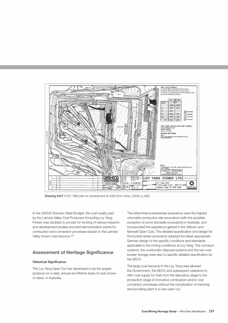
Drawing 9.6/7 LYOC 1995 plan for development at 2000 (from Vines, (2000), p. 406).

260 Coal Mining Heritage Study
Drawing 9.6/8 LYOC 1996 plan for Whole of Life Development within licence boundary (from Vines, (2000), p. 413).
Drawing 9.6/9 Map of Latrobe Valley coal fi eld. Copyright State of Victoria, Department of Primary Industries.

Coal Mining Heritage Study – Mine Sites Identifi cation 261
Scientifi c Signifi cance
The extensive uncommitted coal resource in the Flynn and Gormandale Fields to the east of Loy Yang Open Cut offered scope for a variety of uses other than power generation for coal, with properties similar to that well researched and documented before and during the mining in the Loy Yang fi eld.
The Loy Yang coal had proven suitable in commercial scale plants for conversion to dried pulverised coal (the Lurgi Plant at Loy Yang supplying start up and furnace stabilising fuel for Loy Yang B power station), for briquette manufacture (at the Morwell Briquette Works) and for metallurgical char (with briquettes as fuel and processing feed stock).
In May 2005, the Government announced continued funding, in association with LV Power Generators, to the Co-operative Research Centre for Clean Power from Lignite (CRCCPL).
The provision included establishment adjacent to LYOC of a pilot scale plant using coal at 15 tonnes per hour in a coal drying process with the aim to prove laboratory trials indicating a reduction of water by 70 per cent, reducing greenhouse emissions by 30 per cent in existing power stations and 40 per cent in more modern power plant. Operation of the pilot plant was expected in 2006. This process and others under research offered opportunity for longer term use of Victoria’s major energy resource.
Economic Signifi cance
The economies of scale offered by the larger scale open cut operation at Loy Yang Open Cut compared with the other LV open cuts, as well as the more favourable coal to overburden ratio, demonstrated that generation based on brown coal could be competitive with the cost of base load electricity generation and distribution in Victoria from other fuels. Brown
Table 9.6/1 LYOC Annual output of coal and overburden from 1983 to 1997 (from Vines, (2000), p. 210).

262 Coal Mining Heritage Study
coal resources of similar economic advantages to that being utilised at Loy Yang are available for power generation and coal conversion processes.
In July 2002, after analysis of tenders, the State Government announced the granting of exploration licences external to existing brown coal mining licence areas in the Latrobe Valley. Loy Yang Power received an exploration licence over 1,670 hectares of the Flynn-Gormandale Coal Field with an economically mining reserve of over 1,000 tonnes. In their tender submission, LY Power proposed examining a concept of developing, between 2010 and 2016, a 1,000 megawatt station of four 250 megawatt units using improved brown coal drying technology offering increased effi ciency and reduced greenhouse gas emissions.526 The submission forecasted continued generation from the existing Loy Yang A until 2048, with a further 25 year extension if the existing open cut was approved for extension of its existing mining licence into the exploration licence area.
Australian Power and Energy Ltd. (APEL) was also granted an exploration licence over an area to the east of Loy Yang Open Cut with the objective to produce low sulphur liquid fuels and to install a 500 megawatt power plant with greenhouse gas emissions sequestrated.527
Social Signifi cance
In the early years of operation of the Loy Yang Open Cut in the late 1970s, the initial personnel were selected and transferred from Yallourn and Morwell Open Cuts. Many of the selected personnel were fi rst generation Australians well established in the Latrobe Valley community. No specifi c temporary construction camps or settlements had been necessary in the early construction stage, which had mainly followed on from contract construction in the Yallourn and Morwell/Hazelwood area. In particular, the township of Traralgon, adjacent to the Loy Yang Open Cut, had steady growth as Loy Yang employees tended to take up residence near their work location.
Photo 9.6/8 LYOC View of Open Cut and overburden dump at 1996 (from Vines, (2000), p. 407A).

Coal Mining Heritage Study – Mine Sites Identifi cation 263
The township of Churchill established in the 1950s as a new planned township by the Housing Commission of Victoria was an outcome of the growing need at that time for housing of the workforce engaged in SECV and service activities. The stability of this township and its educational precinct including Monash University Gippsland, has been enhanced by the continuing workforce and servicing needs of the Loy Yang brown coal utilisation.
The proposed long term operation of the Loy Yang Open Cut beyond 2,050 and/or potential opening of other coal resources tends to offset instability in the workforce resulting from greater use of contract and part time work.
A signifi cant downfall in the number of apprenticeships, largely associated with the transfer of maintenance work to short term contracts, has been an adverse feature of the privatisation of the former SECV activities including Loy Yang Open Cut. This defi ciency has been recognised by industry and Government. Combined action to increase apprenticeship numbers is anticipated.
Environmental sensitivity has been a prime feature of the LYOC activities. Community consultation and reporting on compliance with specifi ed objectives have been continuous from the detailed project investigations of the early 1960s.
Mine Infrastructure Features
Traralgon Creek water treatment pondages.
Highland highway deviation.
George Bates Lookout.
Miners Lookout.
Power Works Visitors Centre at Morwell.
High Level Water Storage.
References
Alexander, JM, Planning the Development of Loy Yang Open Cut in Australia, Braunkohle, July 1981
Discovery, Department of Primary Industry, February 2002, August 2002, December 2002, September 2003, December 2004
Drilling Records, held at 1994 by Geo-Eng at Morwell.
Progress Report, No.3, Mines Department, August 1875, p. 284
Herman, H, Brown Coals of Victoria, Bulletin No. 45, Mines Department, 1922
Business Plan, Loy Yang Power, 2005
House Journal, Loy Yang Report, Loy Yang Power
Mineral Statistics, Mines Department, 1876, p. 51
Annual Report, Mines Department, 1889. (Remarks on the Development of the Coal and Lignite Resources of Victoria, Murray, RAF)
Annual Report, Mines Department, 1890.
Vines, JA, A History of the Loy Yang Mine: Its Origins and Development to May 1997, SECV, 2000
264 Coal Mining Heritage Study
10.1 Gelliondale Open Cut
Map Reference: 8220-4-3 Sunday Island Open Cut 4621, 57234
Municipality: Shire of Wellington, Parish of Alberton West
Land Use/Status: Private Ownership
Site History
The existence of brown coal in the Gelliondale area of Gippsland was known since the late 1800s,528 although subsequent to brown coal discoveries by RA Murray in 1876 at Won Wron, which later was identifi ed as a different seam. At 1922, it was stated that there is ‘a large area of open cut brown coal of good quality around Hedley and eastwards within about four miles of Port Welshpool which at a comparatively small cost could be made available for fairly large steamers’. It was also stated that ‘From Toora to near Alberton for a direct length of 18 miles in an east north/easterly direction was a continuous, or nearly continuous, brown coal fi eld’.529 Between 1902 and 1966, the Mines Department and then the SECV drilled 160 bores in the Alberton Depression including the Gelliondale Coalfi eld.530
The Gelliondale coal deposit is located to the west of the Gelliondale Rail Siding on the South Gippsland VR rail line. From Gelliondale, the deposit is located westwards for about eight miles to some two miles to the west of the Hedley Rail Siding and is about 0.5 to 1.5 miles wide.531 The deposit exists on a coastal plain about 30 to 50 feet above sea level and about four to fi ve miles from the coast. At 1950, it was assessed from analysis of bores that the deposit in the Alberton Parish contained 560 million tons of coal over an area of about 4.75 square miles with an average seam thickness of 140 feet and overburden less than 140 feet. Immediately contiguous in the Welshpool Parish, the coal quantity was assessed at about 488 million tons over an area of 5.8
square miles with a somewhat deeper overburden and a lesser coal thickness.532
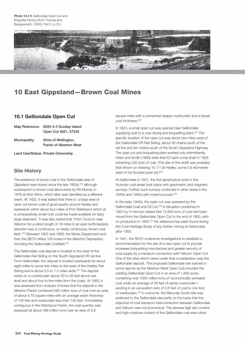
In 1923, a small open cut was opened near Gelliondale supplying coal to a coal drying and briquetting plant.533 The specifi c location of the open cut was about two miles west of the Gelliondale VR Rail Siding, about 30 chains south of the rail line and ten chains south of the South Gippsland Highway. The open cut and briquetting plant worked only intermittently. Greer and Smith (1983) state that ICI sank a trial shaft in 1929 extracting 230 tons of coal. (The site of this shaft was probably that shown on drawing 10.1/1 at Hedley, some 5.6 kilometres west of the fl ooded open pit.)534
At Gelliondale in 1931, the fi rst geophysical work in the Victorian coal areas took place with gravimetric and magnetic surveys. Further such surveys continued in other areas in the 1940s and 1950s with mixed success.535
In the early 1940s, the open cut was operated by the Gelliondale Coal and Oil Ltd.536 A tabulation published in 1952 by H Herman stated that 13,940 tons of coal had been mined from the Gelliondale Open Cut to the end of 1950, with no production in 1950.537 No reference has been found during this Coal Heritage Study of any further mining at Gelliondale after 1950.
In 1941, the SECV undertook investigations to establish a recommendation for the site of a new open cut to provide increased briquetting manufacture and greater security of coal supply by a transport connection with Yallourn Open Cut. One of the sites which came under fi nal consideration was the Gelliondale deposit. The proposed Gelliondale site (named in some reports as the Alberton West Open Cut) included the existing Gelliondale Open Cut in an area of 1,830 acres, containing over 1000 million tons of ‘economically winnable’ coal under an average of 28 feet of sandy overburden resulting in an excavation ratio of 3.6 feet of coal to one foot of overburden.538 In outcome, the Maryvale South site was preferred to the Gelliondale site partly on the basis that the objective of coal transport interconnection between Gelliondale and Yallourn was not economical. The adverse high ash content and high moisture content of the Gelliondale coal were other
10 East Gippsland—Brown Coal Mines
Photo 10.1/1 Gelliondale Open Cut and Briquette Factory (from Thomas and Baragwanath, (1950), Part 2, p.16 ).

Coal Mining Heritage Study – Mine Sites Identifi cation 265
disadvantages. The proximity of the sea for cooling water associated with power generation and the proximity of the ports and rail line for product transport were notable advantages. In September 1944, State Cabinet requested the SECV for information to be provided to private developers on prospects for encouraging private development of the Gelliondale deposit for briquette manufacture. However war time private investment was not forthcoming.
Subsequently, development of the Gelliondale Coal Field did not come under detailed consideration by the SECV for power generation although the SECV fostered private business
interests in utilisation of the resource in coal conversion processes. International Oil Explorations NL (later renamed International Oil Proprietary) commenced a limited exploration program in 1968, with CRA as operator until 1979 and ARCO as operator from 1980 engaged in continuing exploration programs until 1982.
In the Mines Department Annual Report for 1969 it was stated that testing of coal from Gelliondale was occurring with respect to oil production there from.539 During the ‘oil crisis’ of the 1970s prospects for conversion to liquid fuels received private evaluation. Tests were carried out on liquefaction of
Drawing 10.1/1 Gelliondale Open Cut: Plan of brown coal area (from Thomas and Baragwanath, (1950), Part 2, p.15).
266 Coal Mining Heritage Study
Gelliondale coal and ‘a liquids yield of nearly 50 per cent was achieved’.540 International Oil Pty Ltd and ARCO Aust. Ltd. took out exploration licence 1268 in the Gelliondale Area in August 1976 and carried out drilling for aquifer investigations from 1977. A core shed and site offi ces were completed at Gelliondale in October 1982. A mining feasibility study was undertaken by the ARGO/IOL consortium in 1982.541
At 1980, the coal resources of the Gelliondale Lease area as assessed to that time following ‘extensive investigations by the SECV, DME, and a number of private companies’ had the following features: resources: 1,700 million tonnes indicated and 3,500 million tonnes inferred; economic reserves: 1,700 million tonnes including 1,050 million tonnes readily recoverable; moisture content averaging 65.9 per cent with net wet energy 6.6 MJ/kg.542
At 1982, the Gelliondale Coal Resource, typically 50 metres or more thick, was assessed as split in places to form the Gelliondale A and B Seams extending westwards to Toora and southwards with deeper overburden cover to Snake Island. At 1982, an additional coal resource about four to fi ve kilometres east and south-east of the Gelliondale lease area was delineated by the SECV and DME conjointly as the Alberton Coalfi eld having economic reserves of 2,000 million tonnes, generally in two seams of combined thickness of some 55 metres with coal quality marginally better than Gelliondale and in a zone of coal fi ve to six kilometres wide over a distance of 18 kilometres between Alberton and Yarram
townships.543, 544 By late 1982, the ‘World Oil Crisis’ was in abeyance. Further expenditure on the potential Gelliondale Coal to Oil project was not forthcoming. At 1984, the holder of the mining licence in the Gelliondale Coal deposit was ARCO Australia Ltd.
Assessment of Heritage Signifi cance
Historical Signifi cance
The Gelliondale mine was the only privately operated brown coal mine in Gippsland from the 1920s. It appeared to have potential to meet commercial opportunities to relieve shortages of briquette supply and locomotive and shipping fuel from the 1920s to the 1960s. It also indicated possibilities for conversion to liquid fuels and by-products from the 1960s.
Together with the adjacent recently delineated Alberton brown coal deposit with combined coal availability of some 3,000 million tonnes of recoverable coal, a fuel resource of world signifi cance awaits private development as a part of ‘the Huge Fortune in Chancery’ (from H Herman, 1922) represented by the brown coal resources of Victoria.
Scientifi c Signifi cance
The Gelliondale Coal deposit came under a wide variety of technical investigations by public and private organisations. After 1945, the SECV had indicated that this
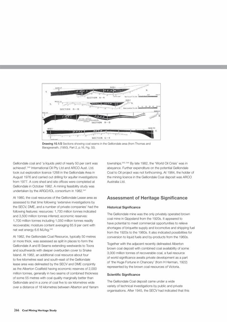
Drawing 10.1/2 Sections showing coal seams in the Gelliondale area (from Thomas and Baragwanath, (1950), Part 2, p.16, Fig. 32).

Coal Mining Heritage Study – Mine Sites Identifi cation 267
Drawing 10.1/3 Depiction of shallow coal areas from Welshpool to Alberton (from Herman, (1952), p.75).

268 Coal Mining Heritage Study
deposit was not as favourable for electricity generation as known available resources in the Latrobe Valley and that the SECV would not oppose its development by private organisations. The technical feasibility of conversion of this coal to liquid fuels had been proven. The properties of the Gelliondale coal deposit were suffi ciently similar to the coal seams in the Latrobe Valley which had been more fully tested than this deposit, such that these fuller investigations were relatively applicable to the Gelliondale seams.
Economic Signifi cance
It appeared that the Gelliondale coal deposit would not be favoured for electricity generation compared with coal resources in the Latrobe Valley, particularly since the granting in 2004 of exploration licences to private fi rms over designated areas in the Latrobe Valley. The outcome of fi nancial grants for development proposals in these areas would appear to defer any similar proposals based on the Gelliondale coal deposit.
The recent (1982) defi nition of the large coal resource at Alberton adjacent to the Gelliondale deposit, which also extends eastward to the township of Toora, offers opportunity of a large scale long term utilisation of these resources in the future either as a combined or sequential development. Preservation of these opportunities for development is of economic signifi cance for Victoria.
Social Signifi cance
The location of the Gelliondale (and Alberton) coal deposits is in an almost pristine coastal plain. The main occupation is agricultural/dairying pursuits on small landholdings serviced locally from several small townships spaced east-west along the South Gippsland Highway. Expectations were high in the late 1970s that further development of the Gelliondale coal deposit for conversion to oil was likely by private interests. It was anticipated that a large scale development would occur which would signifi cantly change the local employment mix and service industries, a taste of which was already being experienced from on and offshore servicing of the natural gas developments in Bass Strait.
Mine Infrastructure Features
Site of Gelliondale Open Cut.
Site of Gelliondale Briquette Factory.
Shaft site near Hedley rail siding.
Identifi able bore site(s) on South Gippsland Highway near Gelliondale.
Drawing 10.1/4 Geology of South Gippsland from Foster to Won Wron (from Thomas and Baragwanath, Part 2, Fig. 29).
Photo 10.1/2 Gelliondale Scarp, east of Toora (from Thomas and Baragwanath, (1950), Part 2, p.13).

Coal Mining Heritage Study – Mine Sites Identifi cation 269
Drawing 10.1/5 Locality of Gelliondale Open Cut (from Topographical Map 8220-4-3 Sunday Island). Copyright State of Victoria, Department of Sustainability and Environment.
270 Coal Mining Heritage Study
References
Garner LJ, Research in Brown Coal Utilisation, Monograph No. 11, AusIMM, 1984
Gloe, CS, The Geology, Discovery, and Assessment of the Brown Coal Deposits of Victoria, Monograph No. 11, AusIMM, 1984
Greer, IR ‘Geological Report to Arco Aust Ltd’, September 1982 to August 1983. Appendix H by Greer, IR and Smith, GL, Australian Coal Geology, Vol. 4 No. 1, pp. 71–89
Herman, H, Brown Coals of Victoria, Bulletin No. 45, Mines Department, 1922
Herman, H, Brown Coal, SECV, 1952
Holdgate, GR ‘Coal Exploration for Lignites: Gippsland Basin 1997’, Australian Coal Geology, Vol. 4 No.1, pp. 57–70
Kitson, AE, Report on the Probable Occurrence of Coal in the Welshpool District, Geological Survey Victoria, Vol. 1 Part 1, 1902, pp. 61–66
Thomas, DE and Baragwanath, W ‘Geology of the Brown Coals Of Victoria’, Mining and Geological Journal, Vol. 1–4, 1949–51
Vines, JA, A History of the Morwell Open Cut, Generation Victoria, 1996
10.2 Won Wron (Yarram) Open Cut
Map Reference: 8221 2S Carrajung Zone 55
7221 Traralgon Zone 55
Mine site 4760, 57410 Zone 55 approx.
Township 4752, 57415 approx.
Municipality: Shire of Alberton, Parish of Won Wron
Land Use/Status:
Site History
The location Won Wron is on the Hyland Highway about 14 kilometres north of Yarram in Eastern Gippsland. Won Wron was previously a rail station about 234 kilometres from Melbourne on the South Gippsland Railway.
Brown coal was fi rst recorded in the Won Wron area by RAF Murray in 1876, ‘in the Middle Creek, between Mac’s and Greig’s creeks, north from Yarram’.545 The deposits in this area were again referred to in Mines Department reports by Stirling in 1892 and 1899, and by Kitson in 1902. An idealised depiction of the Won Wron deposits was made by Stirling in 1899 (p. 78B) as shown below as Drawing 10.2/3. A brief description of the Won Wron brown coal deposit is given by Stirling (1899).546
Shallow shafts were sunk by 1892, at least one of which passed 30 feet into coal without reaching the bottom of the seam. Sixteen bores were put down between 1922 and 1929 on C.A.77, Won Wron. These were depicted by Thomas and Baragwanath,547 showing coal up to 140 feet thick, commencing at eight feet below surface. A further 20 bores were put down in 1954. Bores on the north side of Middle Creek showed little brown coal. On the south of the creek to the western boundary of C.A.77, the main seam of coal on the average was 150 feet thick under 85 feet of overburden. However the overburden increased outside the western boundary and the coal was split into broken seams towards the southern boundary of Lot 77.548
The Mines Department Annual Report for 1955 (on p.15) reported that two workable seams of coal had been located

Coal Mining Heritage Study – Mine Sites Identifi cation 271
at Won Wron. Drawing 10.2/1 shows cross sections of the coal deposit and the open cut as depicted by JL Knight at 1957/58.549
An open cut was commenced circa 1957 by the Won Wron Brown Coal Pty Ltd. There was a temporary lapse in activity but overburden removal recommenced in 1958.551 A record of the quantity of coal extracted from the open cut or the duration of coal excavation has not been found in this study.
Analysis of the main seam showed a calorifi c value varying from 5,560 to 6,460 BTU’s per lb., marginally better than from Yallourn North, Wensley Bray and Thorpdale. The upper seam of thickness from nine feet to 40 feet had a value from 5,265 to 5,650 BTU’s per lb. Ash content varied from 0.8 per cent to 4 per cent.551
The Mines Department Annual Report for 1979 (on p. 46) states that brown coal samples from the Parish of Won Wron were analysed and continuing.
At 1984, the coal deposit at Won Wron was considered to be a small discrete deposit with recoverable coal of the order of two million tonnes. It was geologically associated with a much larger unworked deposit of up to 100 million tonnes at Boodyarn.552 This latter coalfi eld was also associated with again-larger unworked but readily mineable deposits at Stradbroke and Alberton, the coal resources of which came under technical appraisal from the 1950s.
No further details have been ascertained with respect to the Won Wron Open Cut in this study. (In some early documentation, this deposit and mine is referred to as the Yarram coal deposit.)
Drawing 10.2/1 Won Wron (Yarram) Open Cut: Plan and sections (extracted from JL Knight, Mining and Geological Journal, Vol. 6 No. 2, 1957, p. 39).

272 Coal Mining Heritage Study
Drawing 10.2/2 Won Wron (Yarram) Open Cut: Coal and overburden quantities in situ (from Knight, Mining and Geological Journal, 1957, p. 41).
Drawing 10.2/3 Won Wron: Sketch section of brown coal seam (from Stirling, (1899), Plate No. 9).

Coal Mining Heritage Study – Mine Sites Identifi cation 273
Assessment of Heritage Signifi cance
Historical Signifi cance
The brown coal deposit north of Yarram as reported by the Mines Department in 1876 was the fi rst coal discovery so far east in Gippsland. The discovery confi rmed propositions that the extensive brown coal fi elds in the Latrobe Valley probably extended at least as far east as Sale and southwards to the coast south and east of Yarram. The existence of the Won Wron deposit as a coal fi eld, found as an outcrop without basalt or limestone cover, led to extensive drilling in South East Gippsland through to the present time to determine the locations and extent of ‘economically winnable coal’.
From the 1920s, the East Gippsland brown coal deposits were progressively confi rmed and assessed as being widespread, albeit in much of the area being overlain with thicker overburden and limestone. The Won Wron localised deposit without limestone cover was an indication that similar readily minable deposits would possibly be found by more extensive drilling.
Scientifi c Signifi cance
No specifi c scientifi c outcome arose from the discovery and subsequent geological appraisal of this small discrete brown coal deposit. However resultant further coal discoveries and assessments in South East Gippsland stimulated interest by private industry in coal conversion opportunities from the 1920s.
Economic Signifi cance
The small coal output from the discrete coal deposit at Won Wron was of low economic impact in the region or local community. However the possibility exists that, as at Bacchus Marsh and at Anglesea, more economic deposits other than that found ‘by chance in outcrop’ at Won Wron could be discovered from continuing detailed investigations of the widespread deposits in East Gippsland.
Social Signifi cance
The coal discoveries which followed the Won Wron fi nd and the geological appraisal of the wide extent of the regional brown coal deposits kept in the public view the potential for future large scale development of the resource. The scope for industries based on brown coal as feedstock, such as associated with the gas and oil industries, was appreciated as a future possibility.
Mine Infrastructure Features
Remnants of the open cut activities may still be visible.
References
Gloe, CS, The Geology, Discovery and Assessment of the Brown Coal Deposits of Victoria, Monograph No.11, AusIMM, 1984, p. 89
Knight, JL ‘South Gippsland Brown Coal Field at Won Wron,’ Mining and Geological Journal, Vol. 6 No.2, 1957/58, pp. 38–41
Murray, RAF, Progress Report, No.111, Mines Department, 1875/6, p.148
Stirling, J, Progress Report, No.10, Mines Department, 1899, p. 80
Thomas, DE and Baragwanath, W Geology of the Brown Coals Of Victoria, Part 2, Mines Department, p.14

274 Coal Mining Heritage Study

Coal Mining Heritage Study of Victoria – Endnotes 275
Endnotes: Chronology and Contextual History
1 Martin, CH et al. History of Coal Mining in Australia, Monograph No 11, AusIMM, 1993, p. 5
2 ibid.3 Offi cial Yearbook of the Commonwealth of Australia, No. 32,
Commonwealth Bureau of Census and Statistics, Canberra, 1939, p. xxiv
4 Vines, JA, A History of Morwell Open Cut, Hazelwood Power Corporation, Morwell, 1996, p.1
5 Halford, M The Coal Industry of South Gippsland, the Land of the Lyrebird, 1920, p. 230. Halford writes that this was c1938 by Captain Cole who sent it by boat to Melbourne. This coal, mined on the shore, was not from the same seam(s) as that found by Hovell in 1826.
6 Martin, C et al History of Coal Mining in Australia, AusIMM, 1993, p. 8
7 Coglan, J, The State Coal Mine and Wonthaggi, 1979, p. 208 ibid.9 Martin, C et al History of Coal Mining in Australia, 1993, p. 810 Knight, JC ‘The Story of Black Coal in Victoria’, Geological and
Mining Journal, Vol.4 No.4, September 195111 Martin, C et al, History of Coal Mining in Australia, 1993, p. 8.
A year is not stated for this mine in this reference.12 Halford, M, The Coal Industry of South Gippsland. This
reference gives a description of the early Kilcunda mine operations.
13 Owen, Wilfred ‘Miners’, Collected Poems, Chatto & Windus Ltd., 1946, (Reprinted by New Directions Publishing Corporation 1963)
14 Branagan, DF ‘A History of NSW Coal Mining’, The Third Edgewood David Day Symposium, The University of Sydney, 1990
15 Martin, CH et al History of Coal Mining in Australia, AusI.M. M.,Melbourne, 1993, pp. 2–5
16 ibid. p. 317 Heritage in the NSW Coalfi elds, AusIMM, Nov/Dec 2002, p. 7418 ibid. p. 519 Clark, M, Sources of Australian History, Oxford University
Press, London, 1957, p.110
20 Horton, T and Morris, K, The Andersons of Western Port, The Bass Valley Historical Society, Maryborough, 1983, p.19 – states Hovell’s party as consisting of three convicts only.
21 Sutherland, A, Victoria and its Metropolis, McCarron, Bird and Company, Melbourne, 1888, pp.1, 17.
22 Horton and Morris,The Andersons of Western Port, The Bass Valley Historical Society, 1983, p. 66
23 ibid. p. 5524 Labilliere, FP, Early History of the Colony of Victoria, 1878,
pp.1, 246–247. Horton and Morris, The Andersons of Western Port, 1983, p. 72
25 Knight, JL ‘The Story of Black Coal in Victoria’, Mining and Geological Journal, September 1940, p. 39
26 Horton and Morris, The Andersons of Western Port, 1983, p. 66
27 ibid. p. 5528 Knight, JL (1940), p. 3929 Gregory, E. et al Winchelsea: A History of the Shire, 1984,
p. 4830 Information in this paragraph is extracted from Martin, C.H.
et al History of Coal Mining in Australia,1993, pp. 2–331 Heritage in the NSW Coalfi elds, AusIMM Bulletin Nov/Dec
2002, p. 7432 Clark, M. Sources of Australian History, Oxford University
Press, London, 1957, p. 27833 Knight, JL ‘Geological Survey of Victoria’, (unpublished paper)
Mines Department, April 197534 ibid.35 Selwyn, A ‘Report on Cape Paterson Coal Fields’, Geological
Survey Offi ces, October 1867, pp.1–2 36 Brough, Smyth R, Goldfi elds and Mineral Districts –
Carboniferous Rocks, Mines Department, p. 4837 ibid. p. 4838 Mineral Statistics, Mines Department, 1865, p. 4239 Murray, RAF, Early Coal Exploration in Gippsland, Land of the
Lyrebird,Shire of Korumburra, 1920, p.18240 ibid. p.183 41 Coglan, J ‘The Early history of South Gippsland Coal,
1826–1909’, [Extract from The State Coal Mine at Wonthaggi (1909–1968)], 1979, p. 20
42 Brough Smyth, R. 1869, p. 4943 Brough Smyth, R. 1869, p. 436. 44 Mineral Statistics Report, Mines Department,1865, p. 42
Endnotes

276 Coal Mining Heritage Study
45 Thomas and Baragwanath, Geology of Brown Coals of Victoria, Part 1, 1949–51, pp.1–4
46 Progress Report, No 1, Mines Department , 1873, p. 2947 Sutherland, A, Victoria and Its Metropolis, Vol 1, Melbourne,
1888, p. 38448 Victorian Yearbook, 1980 p. 29749 Sutherland, A (1888), Vol 1, p. 38450 Victorian Yearbook, 1980, p. 29751 Vines, JA, A History of Morwell Open Cut, Generation Victoria,
1996, p.14052 Sutherland, A, Victoria and its Metropolis, Vol. 1, 1888, p.19353 ibid. p. 27054 Murray, RAF, Early Coal Exploration in Gippsland, 1920, p.18455 Mineral Statistics, Mines Department, 1872, p. 5256 Mineral Statistics, Mines Department, 1874, p. 5357 Knight JC ‘The Story of Black Coal in Victoria’, Mining &
Geological Journal, Vol. 4 No. 4, 1954, p. 4058 Bowden, K, Early Days of Korumburra, 1967, p.14 59 Borings in search of coal and lignite, Mines Department, 1890,
pp.101–102 and Annual Report, Mines Department, 1890, p. 960 Mineral Statistics, Mines Department, 1873, p. 5261 Murray, RAF, Geology and Mineral Resources of South Western
Gippsland, Mines Department, 1875, pp.158, 15962 Legg S., Heart of the Valley: a History of the Morwell
Community, 1992, p. 7763 Annual Report, Mines Department, 1889, p. 22 64 Legg S. (1992), p. 8265 Adams, J So Tall the Trees, 1978, p. 94 66 ibid. p.10167 ibid. p. 9468 Wells, J, Gippsland – People, a Place, and their Past,
Landmark Press, 1986, p.158. (J Adams, p. 94, places the date as early 1879 and the shaft as 26 metres deep. The workings were visited by a government and municipal party in June 1879, stimulating interest in coal ventures in the Narracan Valley. The company mined a few tons only but collapsed fi nancially in the early 1880s.)
69 Adams, J (1978), p. 9670 ibid. p. 9471 ibid. p. 9572 ibid. pp. 95–9673 ibid. p. 9774 Adams, J (1978), p. 9775 Morwell Advertiser, 1 September 1888, p. 376 Mineral Statistics for Victoria, Mines Department, 1873, p. 52 77 Morley, W ‘The Great Morwell Coal Mining Company’,
(unpublished M.A. thesis), 1983, pp.13–1578 ibid. pp. 40,4179 ‘Brown Coal in the Latrobe Valley’, Mining & Geological Journal,
March 1947, p. 4
80 Stirling, J, Report on the Brown Coals and Lignites of Victoria, Mines Department, 1899, p. 78
81 Wright, J, Notes on the Geological Features of South Gippsland, Mines Department, 1894, p. 34
82 Stirling, J, Report on the Brown Coals and Lignites of Victoria, Mines Department, 1899, p. 75
83 ibid.84 ibid.85 Adams, J (1978), p.10586 Stirling, J (1899), pp. 73, 7787 Morwell and Mirboo Gazette, 189088 Adams, J (1978), p.10589 ibid. p.10490 Stirling, J, Report on the Brown Coals and Lignites of Victoria,
Mines Department, 1899, p. 7491 Adams, J (1978), p.10492 Thomas and Baragwanath (1950), Part 3, p.1293 Mineral Statistics, Mines Department, 1878, p. 4994 Priestley, S, Altona – A Long View, City of Altona, 1988, p. 8695 Priestley, S (1988), p. 86 dates this bore and mining at 1982.96 Thomas and Baragwanath (1950), Part 3, p.12 and Gloe, C
(1984) state that shaft sinking and actual mining of brown coal also occurred at Newport at 1890.
97 Gregory, E et al. Coast to Country: A History of the Winchelsea Shire, Winchelsea, 1984, p. 48
98 Geological Survey Progress Report, No. 1, Mines Department, 1873, p. 29
99 Gregory, E et al. (1984), p. 48100 Wells, J, (1986), p.163101 Adams, J(1978), p. 98102 ibid.103 ibid. p.100104 ibid.105 ibid.106 Wells, J, (1986), p.160 Adams, J(1978), p.100107 Adams, J, (1978), p.101108 White, J, History of the Shire of Korumburra, Shire of
Korumburra, 1987, p. 271. Extensive use of this reference has been made with quotation of page number. The author J White has made specifi c references to his source documents thus facilitating further research.
109 Bowden, K, The Early Days of Korumburra, 1967, p. 59110 White, J (1987), pp.133,134111 ibid. p.126112 ibid. p.122113 ibid.114 ibid. p.122115 ibid. p.128116 Bowden, K (1967), p. 67117 White, J (1987), p. 271

Coal Mining Heritage Study of Victoria – Endnotes 277
118 ibid. p.128 Bowden, K (1967), pp. 67, 78119 Bowden, K (1967), p. 85120 Harper, P The Wonthaggi Coal Fields, Electrical Industry
Advertising, Oak Park, 1987, p. 79 White, J (1987), p.129 Bowden, K (1967), p. 79
121 White, J (1987), p.130122 Harper, P(1987), p. 79123 Halford, M The Coal Industry of South Gippsland, c1910,
pp. 234–237124 White, J (1987), p.131125 Halford, M (c1910), p. 236126 Gleeson, K ‘The Rise and Fall of Outtrim’, The Korumburra
Times, 16 September 1965, p. 71127 White, J (1987), p.132128 Bowden, K (1967), p. 79129 White, J (1987), p.132130 Harper, P (1987), p. 9131 ibid. pp.17–20132 Coglan, J The State Coal Mine and Wonthaggi, 1979, p. 78
Harper, P (1987), p. 55133 Halford, M (c1910), p. 236134 ibid. p. 236135 Harper, P (1987), p. 20136 bid. p.17137 ibid. pp. 34, 81, 99, 100138 ibid. p. 33139 Fahey, C Wonthaggi State Coal Mine, Department of
Conservation, Forests and Lands,1987, p. 21140 ibid. pp. 23, 24141 ibid. p. 24142 Herman, H Brown Coals of Victoria, Mines Department,
1922, p. 6143 Mineral Statistics, Mines Department, 1878, p. 49144 Thomas and Baragwanath (1949), Part 1, p. 4145 ibid. Herman, H (1922), p.7146 See Fig 14147 Gloe, C ‘The Geology Discovery and Assessment of the Brown
Coal Deposits of Victoria’, Victoria’s Brown Coal, AusIMM, 1984, p. 95
148 Thomas and Baragwanath (1949), Part 1, p. 4149 Thomas and Baragwanath (1950), Part 3, p.12 150 ibid.151 Stirling, J (1899), p. 82152 Priestley, S (1988), pp.112, 113153 Priestley, S (1988), p.104. See also Herman (1952), p. 49 for
annual outputs.154 Australian Mining Standard, 15 August 1912, p.157 and
Australian Mining Standard, 17 March 1921, p.13155 Priestley, S (1988), p.113156 ibid. pp.134, 135
157 Mining and Geological Journal, March 1947, p. 7, Table 11 158 Herman, H, Brown Coal, SECV, 1952, p. 49159 Kenny, JPL ‘Benwerrin Brown Coal Mine’, Mining and
Geological Journal, March 1947, p.10160 Thomas and Baragwanath (1950), Part 3, p.18
Herman, H (1952), p. 5161 Kenny, JPL (1947), p.10 162 Thomas and Baragwanath (1950), Part 3, p.18163 Millard, R, The Deans Marsh Story, Geelong, 1985, p. 57164 Thomas and Baragwanath (1950), Part 3, p.18. Drucker
(1984), p. 48, states that the mine at Benwerrin was an open cut operation. I have not yet found confi rmation of this. Others including Herman, H (1952) refer to tunnelling operations, which is more likely.
165 Herman, H (1922), p. 7166 ‘Brown Coal in the Latrobe Valley’, Mining and Geological
Journal, March 1947, p. 6167 Herman, H (1922), pp. 7, 8168 Mining and Geological Journal, March 1947, pp. 6–8 169 Herman, H (1922), p. 8170 Herman, H (1952), pp.157–159 171 ‘Power for Victorian Industries’, The Industrial Australian and
Mining Standard, 17 March 1921, pp. 20–25172 White, J (1987), p.126173 ibid. p.134174 White, J (1987), p.128175 ibid. p.133176 ibid. pp.134, 135177 Harper, P (1987), p. 79. Details stated in Harper are quoted
from G Broome, Manager of the State Mine. 178 White, J (1987), p.133 – from information extracted from
specifi ed company records and Mines Department records.179 Fahey, C, Wonthaggi State Coal Mine, Department of
Conservation Forests and Lands, 1987, pp.17–19. Fahey states Knight, JL ‘The Closing of the State Coal Mine Wonthaggi’, Mining & Geological Journal, Vol. 6 No. 6 1970, p. 63 as his information source.
180 Fahey, C (1987), p. 24. Fahey states JL Knight (1970), p. 66 as his information source.
181 ibid.182 Fahey, C (1987), p. 47. Fahey states JL Knight (1970),
pp. 65–66 as his information source. 183 ibid.184 Fahey, C (1987), p. 24. Fahey states JL Knight (1970),
pp. 63–64 as his information source. 185 Fahey, C (1987), p. 25. Fahey states JL Knight (1970), p. 66 as
his information source186 Fahey, C (1987), p. 48. Fahey states JL Knight (1970), p. 66 as
his information source.

278 Coal Mining Heritage Study
187 Fahey, C (1987), pp. 48–49. Fahey states JL Knight (1970), pp. 66–68 as his information source.
188 Fahey, C (1987), p. 53. Fahey states JL Knight (1970), p. 68 as his information source.
189 Harper, P (1987), p.141 and JL Knight (1970)190 Harper, P (1987), p.17191 ibid. p.17192 Griffi ths P. Three Times Blest: A History of Buninyong and
District, Buninyong and District Historical Society, 1988, p. 99193 Brown, G ‘Coal Resources in Victoria’, Mining & Geological
Journal, September 1948, p.11194 Thomas and Baragwanath (1950), part 3, p.14195 Griffi ths P. (1988), p.100196 ibid.197 Herman, H (1952), p. 49 198 Priestley, S (1988), p.168199 Priestley, S (1988), pp.168,169200 Kenny, JPL ‘Benwerrin Brown Coal Mine’, Mining & Geological
Journal, March 1947, p.10201 ibid. 202 ibid.203 Mining & Geological Journal, March 1947 to September 1948204 Herman, H (1952), p. 49 and Table 11205 Thomas and Baragwanath (1950), Part 3, p.17 and Vol. 3,
p. 23206 Thomas and Baragwanath (1950), Part.3, pp.18 and 22 to 24207 Millard, R (1985), p. 58208 ibid.209 Thomas and Baragwanath (1950), Part 3, p.18. Date of mining
commencement is stated as 1921. 210 Herman, H (1952), pp. 49, 85211 Thomas and Baragwanath (1950), Part 3, pp.18, 19212 Thomas and Baragwanath (1950), Part 3, p.19 use this
nomenclature but the spelling Wensleybrae is also used by others. The name Winchelsea South Coal Mine was also used colloquially.
213 Swift, D ‘The Wensley Bray Brown Coal Mine’, Mining & Geological Journal, March 1948, p.10
214 Thomas and Baragwanath (1950), Part 3, pp.18, 19. Herman, H (1952), p. 85. Note that Herman’s descriptive location of the mine is incorrect, the mine being about fi ve miles north west of Deans Marsh not south east thereof.
215 Gregory, E et al. Winchelsea: A History of the Shire, 1984, p. 48
216 Gregory, E et al. (1984), p.140, 141. A photo of the mine when under Roche Brothers operation is shown on page 141.
217 ibid. p.134218 Gloe, C (1984), p. 81219 ibid. p.134220 Gloe, C (1984), p. 97
221 Edwards A. Fuel, 1950, Vol 29, p.125 Thomas and Baragwanath (1951), Part 4, p.15
222 Gloe, C (1984), p. 81223 Thomas and Baragwanath (1949), Part 1, p. 5 Gloe, C (1984), p. 98224 Herman, H. (1952), p. 81. Note that the depth and thickness
of the coal, and the levels at which the mine was worked as stated by Herman do not reconcile with the fi gures as stated by Thomas and Baragwanath (1949), part 1, p. 5 or as stated by Gloe (1984), p. 81.
225 Gloe, C (1984), p. 98226 Annual Report, Mines Department, 1947227 Thomas and Baragwanath (1950), Part 3, p.10. This output
fi gure appears to be low. Another source states 120,000 tons by 1947.
228 Herman, H (1952), p. 49229 Annual Report, Mines Department, 1954230 Thomas and Baragwanath (1950), Part 3, p.10231 Herman, H (1950), p. 49232 Thomas and Baragwanath (1950), Part 3, p.10 and Herman, H
(1950), p. 49233 Thomas and Baragwanath (1950), Part 3, p.10 and Herman,
H(1952), p. 49234 Mining & Geological Journal, March 1951, March 1952 and
September 1952 235 Thomas and Baragwanath (1951), Part 4, p. 8, 9236 Thomas and Baragwanath (1951), Part 4, pp. 8–10237 Annual Report, Mines Department, 1948238 Annual Report, Mines Department, 1947 and 1948239 Thomas and Baragwanath (1951), Part 4, pp. 8–10240 Assessed from Annual Reports, Mines Department
1947 to 1965241 Vines, JA, A Technical History of Yallourn North and Yallourn
North Extension Open Cuts, SECV, 1989, p.13 242 Vines, JA Train Systems –Yallourn and Morwell Open Cuts,
Generation Victoria, 1994, pp. 31–35243 Vines, JA, A History of Morwell Open Cut, Generation Victoria,
1996, p.140 and Table 8.3/1244 Rusden, GF, History of Yallourn, Yallourn North and Yallourn
North Extension Open Cuts 1947–1965, SECV, 1968. Appendix 10 is the source of annual coal outputs 1924 –1963.
245 Vines, JA (1994), p. 35. See Photo 1.31/5246 Rusden, GF (1968), pp. 82–84, 98247 Vines, JA (1989), p. 93248 Vines, JA (1989), p. 67, Table 5.1/2249 Brown, K et al Yallourn North Extension Open Cut Interim
Rehabilitation, Rehabilitate Victoria, AusIMM, 1992, pp. 71–76250 Vines, JA, A History of Morwell Open Cut, Generation Victoria,
1996, pp. 7–11251 Vines, JA (1994), pp.17, 21

Coal Mining Heritage Study of Victoria – Endnotes 279
252 Rodgers, HC ‘Excavation Equipment for Brown Coal’, Proceedings, AusIMM, 1960, No. 164, Fig. 1 Cross Section showing proposed disposition of dredgers in Yallourn South Field circa1962/63. Number 13 dredger was subsequently installed in 1977 and number four dredger was retired.
253 ‘Yallourn Energy-Alliance Mining Innovations’, AusIMM Journal, Jan/Feb 2003. pp. 22–24
254 Vines, JA (1994), p.143, Table 6.15/4 and p. 241 Table 9/1 and p. 242 Table 9/2
255 Live Wire, Yallourn Energy, January 2003, p. 2256 Vines, JA (1996), pp.18–38257 Vines, JA (1996), pp.101–116258 Vines, JA (1996), pp. 264, 265259 Jumbunna, International Power Hazelwood, Vol. 9 No. 5
(August 2003), p. 7 and Vol. 9 No. 6 (Sept 2003), p. 3 and Vol.10 No.1, (Jan/Feb 2004), pp. 3, 10–13
260 ‘This River is a Mover’, Discovery, Dept of Primary Industries, February 2003, pp.10, 11
261 Vines, JA (1996), p.109, See Table 7.5/3262 Vines, JA, A History of the Loy Yang Mine, SECV, 2000, p. 97263 ibid. p. 221264 ibid. pp. 310–316265 ibid. p. 293 and Table 9.1/1; see also Table 7.1.1/1 266 ibid. pp.180, 295–297267 ibid. p. 379268 ibid. p. 210 See Table 7.1.1/1269 Information from I. Draper, Statistics Offi cer Loy Yang Mine, on
11 March 2004. 270 Speirs, C ‘A mine with a view for the future’, House Journal,
Loy Yang Power, 19 July 2000, pp. 3–5271 Speirs, C ‘Loy Yang Mine marks 20 years’, Discovery,
Department of Natural Resources & Environment, December 2002, p. 20.
272 Gloe, C (1984), pp. 85, 91. 273 Herman, H (1952), p. 49274 Greer, I & Smith, GO ‘Geology of the Gelliondale Coalfi eld’,
Australian Coal Geology, Vol. 4 No. 1, 1982, pp. 71–79 and Gloe, C (1984), p. 95
275 ibid. (1984), p. 90276 Stirling, J, Progress Report, Mines Department, No.10, 1899,
p. 76277 Thomas, DE and Baragwanath, W, Geology of the Brown Coals
of Victoria, Part 2, 1950, p.14278 Gloe, CS, The geology, discovery and assessment of the
brown coal deposits of Victoria, AusIMM Monograph Series, No 11, 1984, p. 89
279 Knight, JL ‘South Gippsland Brown Coal Field at Won Wron’, Mining & Geological Journal, Vol. 6, No. 2, c1969, pp. 38–41
280 ‘Eight Billion Dollars in brown coal proposals’, Discovery, Department of Natural Resources & Environment, August 2002, pp. 5–7
281 Jumbunna, International Power Hazelwood, Jan/Feb 2004, p.15
Endnotes: Mine Sites Identifi cation1 Thomas, DE and Baragwanath, W ‘Geology of the Brown
Coals Of Victoria’, Part 1, p.1, Mining and Geological Journal Vol. 3 No. 6 Sept. 1949 (This publication was initially published in four consecutive parts in the Mining and Geological Journal from Sept. 1949 to March 1951 and subsequently reprinted in four parts by the Department of Mines Victoria. The Mines Department pagination will be used in this Coal Heritage Study in further references to this four part document. )
2 ibid.3 ibid.4 Garner, EL & Barton, C, The Importance of Lignite in South
Asia, AusIMM Spectrum Series No. 8, 1987, p.15 Horton, T and Morris, K The Andersons of Western Port, Bass
Valley Historical Society, 1983, p. 55(This publication has numerous references to early source documentation. Some writers incorrectly attribute the coal discovery at Cape Paterson to the exploration of Hume and Hovell in 1824 which did not reach Western Port.)
6 ibid. p. 557 ibid. p. 548 ibid. pp. 66–72 9 ibid. pp. 72–7310 Knight, JL ‘The Story of Black Coal in Victoria’, Mining and
Geological Journal Vol. 4 No. 4 , September 1951, p.3911 Royal Commission on Coal, 18 December 1891, p.1912 Knight, JL (1951), p.4013 Knight, JL (1951), p.3914 Selwyn, A, Cape Patterson Coal Fields, Mines Department,
1867, p. 215 Brough Smyth, R ‘Goldfi elds and Mineral Districts 1869’,
Carboniferous Rocks, 1869, p. 4816 Knight, JL (1951), p. 4017 Knight, JL ‘The Closing of the State Coal Mines , Wonthaggi’,
Mining and Geological Journal, Vol. 6 No. 6, 1970, p. 7318 Knight, JL (1951), p. 4019 Coglan, John, in ‘The Early history of South Gippsland Coal,
1826–1909’, The State Coal Mine at Wonthaggi 1909–1968, p. 20

280 Coal Mining Heritage Study
20 Mineral Statistics, Mines Department, 1864, p. 38 and 1865, p. 42
21 ibid.22 Mineral Statistics, Mines Department, 1864, p. 38 23 Selwyn, Alfred, Report on Coal Seams, Cape Patterson, Mines
Department, 1867, p. 224 Mineral Statistics, Mines Department, 1874, p. 5325 Mineral Statistics, Mines Department, 1875, p. 5126 Murray R. A. F, Report on the Geology and Mineral Resources
of South West Gippsland, Mines Department, 6 August 1875, pp.159–160
27 Coglan, John, in ‘The Early history of South Gippsland Coal, 1826–1909’, The State Coal Mine at Wonthaggi, 1909–1968, p. 20
28 Horton, T and Morris, K, The Andersons of Western Port, Bass Valley Historical Society, 1983, p.118
29 Coglan, John, in ‘The Early history of South Gippsland Coal, 1826 – 1909’, The State Coal Mine at Wonthaggi, 1909 – 1968, 1979, p.20, says the WPCC was formed in 1865.
30 Horton, T and Morris, K (1983), pp.117–11831 Mineral Statistics, Mines Department, 1872, p. 5232 ibid.33 Horton, T and Morris, K (1983), p.120 (The quantity may be
overstated. Mineral Statistics, 1874 records 4,589 tonnes mined, but it was not unusual for quantities of coal as stated by operators to the Mines Department to be lower than actual.
34 ibid. p.122 35 Knight, JL ‘The Closing of the State Coal Mines, Wonthaggi,’
Mining and Geological Journal, Vol. 6 No. 6, 1970, p. 5436 Horton, T and Morris, K (1983), p.139. However, John Coghlan,
in ‘The Early history of South Gippsland Coal,1826–1909’, The State Coal Mine at Wonthaggi, 1909–1968, p. 20, says the mine closure was 1883. Interpretation of Horton and Morris suggests 1893 as being the more likely date.)
37 Mineral Statistics, Mines Department, 1873 and 187438 Brown, George ‘Coal Resources of Victoria’, Mining and
Geological Journal, September 1948, p.639 Mining and Geological Journal, Mines Department,
March 1947, p. 4840 ibid. September 194841 Brown, George (1948), p. 642 Annual Report, Mines Department, 1954.43 Mining and Geological Journal, Mines Department,
March 1947 to March 195044 ibid. March 1952 and March 195345 ibid. September 195346 ibid. September 1948 47 Annual Report, Mines Department, 194748 Mining and Geological Journal, Mines Department,
March 1947 to March 1950
49 Knight, JL ‘Coast Coal Mine Woolamai’, Mines Department memo to Chief Government Geologist, 3 May 1957
50 Mining and Geological Journal, Mines Department, September 1952
51 Annual Report, Mines Department, 195452 Knight, JL ‘Coast Coal Mine Woolamai’, Mines Department
memo to Chief Government Geologist, 3 May 195753 Annual Report, Mines Department, 1966, p. 2254 Bowden, K, Early Days of Korumburra, 1967, p.1355 Murray, RAF Early Coal Exploration in Gippsland, Land of the
Lyrebird, Shire of Korumburra, 1920, pp.182–190. 56 Progress Report, No 3, Mines Department, 1876, pp.156–15757 Bowden, K (1967), p.1558 Annual Report, Mines Department, 188959 Annual Report, Mines Department, 189060 Annual Report, Mines Department, 189161 White, J The History of the Shire of Korumburra, 1987, p.12162 Bowden, K (1967), p. 55 63 Company Records No. 4651, Public Records Offi ce64 Bowden, K (1967), p.1465 ibid. p. 7866 White, J The History of the Shire of Korumburra, 1987, p.12167 White, J (1987), p.13468 Korumburra Times, 5 September 1968, as referred to by
J White (1987), p.13569 White, J (1987), p.11970 Company Records No. 5109, Public Records Offi ce71 White, J (1987), pp.119–12172 ibid. p.119 and Southern Mail, 27 May 189573 ibid. p.12174 Company Records No. 8732, Public Records Offi ce75 Mining and Geological Journal, Mines Department, March 194276 Kenny, JPL Boring on the Korumburra Coal Field, September
1947, p. 3477 Mining and Geological Journal, Vol. 6 No. 2, Mines Department,
195778 Murray, RAF Geological Survey Progress Report, No. 3, 1876,
pp.156–157 79 White, J (1987), p.13380 White, J (1987), pp.133–13481 White, J (1987), p.134. Most of the information in this Section
3.1.4 has been taken from J White (1987), with some additions from Bowden, K (1967). Where company record numbers in the Public Records Offi ce are quoted, these have been extracted from White, J (1987).
82 Company Records No. 5187, Public Records Offi ce83 White, J (1987), p.12684 White, J (1987), p.122. Other fi gures quoted by White
pp.122–125 state total excavation varying from about 26,000 to 49,500 tonnes.
Coal Mining Heritage Study of Victoria – Endnotes 281
85 White, J (1987), p.12886 White, J (1987), p.133 referring to The Advocate,
17 September 192587 White, J (1987), p.133 referring to The Korumburra Times,
30 January 193788 Annual Report, Mines Department, 194989 Kenny, JPL ‘Coal Near Warragul,’ Mining and Geological
Journal, March 1947, pp.18–1990 ibid.91 Murray, RAF ‘Recollections and Experiences’, Annual Report,
Mines Department, 1891, p. 300Murray, RAF, Remarks on the Development of the Coal and Lignite Resources of Victoria, 1889, p.22
92 Harper, P, The Wonthaggi Coal Fields, E. I. Advertising, 1987, p. 79
93 White, J (1987), p. 27194 See VR Jumbunna and Outtrim Railway Map 1895, No.13895 White, J (1987), p.13096 Harper, P (1987), p. 86 and p.19 states closure as 1929. White,
J (1987) says 1939. There was a suspension of operations in 1929 but mining resumed in 1931until 1939.
97 White, J (1987), p.12998 Harper, P (1987), p. 79 99 Mining and Geological Journal, Mines Department, March
1947, p.51100 Harper, P (1987), p.79101 White, J, The History of the Shire of Korumburra, 1987, p.131102 Murray, RAF ‘Recollections and Experiences’, Annual Report,
Mines Department, 1891, p.301103 Wells, John Gippsland: A People, a Place, and their Past,
Landmark Press, 1986, p.162104 Gleeson, K ‘The Rise and Fall of Outtrim’, The Korumburra
Times, 16 September 1965, p.71105 White, J (1987), p.131 106 ibid.107 Company Records Nos. 4792, 5145, Public Records Offi ce.108 White, J (1987), p.132109 Mining and Geological Journal, Vol. 6 No. 2, Mines
Department, 1957110 Brown, G ‘Coal Resources of Victoria’, Mining and Geological
Journal, September 1948, p.7111 Knight, JL ‘The Story of Black Coal in Victoria’, Mining and
Geological Journal, Vol. 4 No. 4, 1954, p. 41112 Brown, G (1948), p. 7113 Harper, P, The Wonthaggi Coal Fields, E.I. Advertising, 1987,
p. 7114 Fahey, C, Wonthaggi State Coal Mine, Wonthaggi Coal Mine
Committee, 1987, p.15 115 The Melbourne Age, 28 October 1909116 Harper, P (1987), p. 9
117 ibid.118 ibid. p. 34119 ibid. p. 81120 ibid. pp. 99, 100121 Fahey, C (1987), pp. 55, 56122 Knight, JL ‘The Closing of the State Coal Mines, Wonthaggi’,
Mining and Geological Journal, Vol. 6 No. 6, 1970, p. 53123 Fahey, C (1987), p. 56124 Knight, JL (1970), p. 68125 ibid.126 Knight, JL ‘The Closing of the State Coal Mines, Wonthaggi’
Mining and Geological Journal, Vol. 6 No. 6, 1970, p. 70127 Sleeman, J, Black Coal In Gippsland, 1976, p. 4128 Harper, P, The Wonthaggi Coal Fields, E. I. Advertising, 1987,
p. 55129 Knight, JL (1970)130 Adams, John, So Tall the Trees, p.93. The majority of
information collated in this sub-Section has been taken from interlocking information in this John Adams writing, pp. 93–99, and from John Wells’ Gippsland: A People, a Place, and their Past, 1986, pp.158–161
131 Wells, John, Gippsland: A People, a Place, and their Past, 1986, p.158
132 Mineral Statistics, Mines Department, 1876, p. 51133 Wells, John (1986), p.158134 ibid. pp. 95–96135 Ringin, Kath ‘Bundilla and Coalville’, Coach News, June 1983,
pp.10–12136 Wells, John, Gippsland: A People, a Place and their Past,
pp.158 –161137 Daley, C, The Story of Gippsland, 1960, p.132138 Adams, John, p. 97139 Hillbrick, G ‘Memories of Coalville’, Coach News 140 Ringin, Kath ‘Bundilla and Coalville’, Coach News, June 1983141 Wells, John, Gippsland: A People, a Place and their Past,
1986, p.158142 Kenny, JPL ‘The Hazelwood Coal Seam’, Mining and
Geological Journal, March 1947, pp.19–20143 The Gippsland Times, 24 November 1874144 Murray, RAF ‘Report on the Geology and Mineral Resources of
South Western Gippsland’, Geological Survey Progress Report, No. 3, 1876, pp.158–159
145 ibid.146 Murray, RAF Geological Survey Progress Report, No. 7, 1883,
p.74147 Kenny, JPL ‘The Hazelwood Coal Seam’, Mining and
Geological Journal, March 1947, pp.19–20148 Legg, Stephen M, Heart of the Valley: A History of the Morwell
Municipality, 1992, pp. 76–77149 The Morwell Advertiser, 3 March 1883

282 Coal Mining Heritage Study
150 ibid. Legg (1992), pp. 78–79151 ‘Borings in search of Coal and Lignite or Brown Coal’, Annual
Report, Mines Department, 1890, p.102152 Annual Report, Mines Department, 1889, pp. 21–22153 Knight, JL ‘The Story of Black Coal in Victoria’, Mining and
Geological Journal, Vol. 4 No. 4, September 1951, p. 41154 Annual Report, Mines Department, 1890, p. 9155 Progress Report, Mines Department, No. 10, 1899, pp. 4, 5 156 Murray, RAF, Geological Survey Progress Report, No. 3, Mines
Department, 1876, p.159157 ibid.158 The Morwell Advocate, 6 October 1888, p. 3159 Stirling, J, Reports on the Victorian Coal Fields, Report on the
Yarragon District, 1892, p.16160 ibid.161 Annual Report, Mines Department, 1889, p. 92162 Annual Report, Mines Department, 1890, p.101163 Mining and Geological Journal, Vol. 6 No.2, 1957164 Annual Reports, Mines Department, 1957, 1958, 1959165 Murray, RAF, Annual Report, Mines Department,1890, p. 9166 Dickers Mining Record, June 1864, p.100. A visit to the
Lignite Deposits at Lal Lal, near Ballarat. This article provides a contemporary account of the lignite discovery and early development of the lignite mining at Lal Lal.
167 Griffi ths, Peter M, Three Times Blest: A History of Buninyong and District, 1837–1901, Buninyong and District Historical Society, 1988, opposite p.1
168 Dickers Mining Record, June 1864, p.100169 ibid.170 ibid.171 Minerals Statistics, Mines Department, 1864, p. 88172 Dickers Mining Record, June 1864, p.100173 Dickers Mining Record, June 1864, p.101. The Victoria Lignite
Company, Lal Lal near Ballarat. 174 ibid.175 Minerals Statistics, Mines Department, 1864, p. 38
The 200 tons mined previously from the second prospecting shaft had been mined spasmodically for product trials and was not offi cially recorded in Mines Department production records or statistics.
176 Minerals Statistics, Mines Department, 1865, p. 48177 Brough Smyth, R, Goldfi elds and Mineral Districts, Mines
Department, 1869, p.436 178 ibid. p.437179 Griffi ths, Peter M, Three Times Blest: A History of Buninyong
and District, The Buninyong & District Historical Society, 1988, p.95
180 Mineral Statistics, Mines Department, 1870, p. 48181 Mineral Statistics, Mines Department, 1878, p. 49
182 Thomas, DE and Baragwanath, W Geology of the Brown Coals of Victoria, Part 3, Mines Department, 1950, p.15
183 Griffi ths, Peter M (1988), p. 99184 Herman, H, Brown Coals of Victoria, Bulletin No. 45, Geological
Survey of Victoria, 1922, p. 7185 Griffi ths, Peter M (1988), p. 99186 Kenny, JPL Victorian Central Brown Coal Mine, Lal Lal, Mines
Department, 1921. Drawing signed by JPL Kenny on 12 November 1921, now on microfi che DRMG CM 2002/5/1 and 2002/B/1. This same layout of the underground workings and adjacent bores and shafts is also shown by Jenkins, HC (1920), Brown Coal Mine, Parish of Lal Lal, Microfi che DRMG CM 2466/D/@.
187 Griffi ths, Peter M (1988), p.100188 ibid.189 Thomas, DE and Baragwanath, W, Geology of the Brown Coals
of Victoria, Part 3, Mines Department, 1951, p.17. Pages 14 to 17 of Part 3 of this publication provide a geological analysis of the Lal Lal brown coal deposit.
190 Mining and Geological Journal, March 1952 and September 1952
191 Brough Smyth, R, Goldfi elds and Mineral Districts 1869, Mines Department, 1869, pp. 436–438
192 Minerals Statistics, Mines Department, 1865, p. 43193 Griffi ths, Peter M. (1988), p.16. Map of gold leads south of
Ballarat c.1860.194 Progress Report of Geological Survey, No.111, Mines
Department, 1876, p. 284195 Mineral Statistics, Mines Department, 1874, p. 54196 Progress Report, No. 1, Mines Department, 1873, p. 29197 Progress Report, No. 3, Mines Department, 1876, pp.172,173198 Mineral Statistics, Mines Department, 1875, p. 51199 ibid.200 Mineral Statistics, Mines Department, 1873, p. 53201 Gloe, CS, Geology of Brown Coal Deposits,
Monograph No.11, AusIMM, 1984, p. 97202 Progress Report, No. 2, Mines Department, 1874, p.8203 ibid.204 Progress Report, No. 3, Mines Department, 1876, pp.149, 172205 From the Dawning: A History of Yarragon and District, Back to
Yarragon Committee, March 1978, p.120206 Stirling, J ‘Report on the Brown Coals and Lignites of Victoria,’
Progress Report, No. 10, Mines Department, 1899, p. 74
207 ibid.208 Thomas, DE and Baragwanath, W Geology of the Brown Coals
of Victoria, Part 1, Mines Department, 1949, p.11 209 From the Dawning (1978), p.120210 ibid. p.121211 Stirling, J (1899), p. 74

Coal Mining Heritage Study of Victoria – Endnotes 283
212 Stirling, J, Report on the Victorian Coal Fields Report on the Yarragon District, Mines Department, 1892, pp.15–17
213 From the Dawning (1978), p.121214 Adams, John, So Tall the Trees, 1978, p.105215 Stirling, J (1892), p.15216 Fraser, N ‘Exploration Licence 1800 Trafalgar’, Final Report to
the Mines Department, 1983, p. 8217 Stirling, J Report on the Yarragon District, Mines Department,
1892, pp.15–16218 From the Dawning (1978), p.103219 ibid.220 Stirling, J ‘Report on the Brown Coals and Lignites Of Victoria’,
Progress Report, No. 10, Mines Department, 1899, p.75221 Adams, John, So Tall the Trees, 1978, p.97222 ibid.223 Thomas, DE and Baragwanath, W Geology of the Brown coals
of Victoria, Part 4, Mines Department, 1951, pp. 8–10224 Stirling, J (1899), Plate No. 5225 Thomas, DE and Baragwanath, W (1951) pp. 8–10226 ibid.227 Stirling, J (1899), p.75228 Stirling, J (1899), Plate 6229 Thomas, DE and Baragwanath, W (1951), p.10230 Stirling, J (1899), p. 75231 ibid.232 Annual Report, Mines Department, 1947233 Annual Report, Mines Department, 1948234 Thomas, DE and Baragwanath, W (1949), Part 1, pp.10,11,17235 Thomas, DE and Baragwanath, W (1951), Part 4, p. 8236 Mining and Geological Journal, March 1955237 Mineral Statistics, Mines Department, 1873, p. 52238 Stirling, J ‘Report on the Brown Coals and Lignites of Victoria’,
Progress Report, No. 10, Mines Department, 1899, p. 74 Gloe, CS Geology of Brown Coal Deposits, Monograph No.11, Mines Department, 1984, p. 97
239 Mineral Statistics, Mines Department, 1873, p. 52240 ibid.241 Annual Report, Mines Department, 1889, p.93242 Borings in search of Coal and Lignite or Brown Coal, Mines
Department, 1890, p.103 Stirling, J ‘Report on the Brown Coals and Lignites of Victoria’, Progress Report, No. 10, Mines Department, 1899, p. 74
243 The Morwell and Mirboo Gazette, 1890. Some dates in this reference are in disagreement with those signifi ed in the Company Agreement dated 19 December 1889.
244 Stirling, J (1899), p. 77245 Final Report, Royal Commission on Coal, December 1891,
pp. 267–269246 Stirling, J (1899), p. 76247 ibid. Plate 7
248 Vines, JA, Technical History of Yallourn Open Cut, SECV, 1989, pp. 72–73
249 Thomas, DE and Baragwanath, W Geology of the Brown Coals of Victoria, Part 4, 1951, pp. 8–10
250 ibid. pp. 6–8 251 Stirling, J (1899), p. 79252 Thomas, DE and Baragwanath, W Geology of the Brown Coals
of Victoria, Part 4, Mines Department, 1951, pp. 5–6253 The Cyclopaedia of Victoria, 1905, p. 554254 Australian Mining Standard, 1 August 1912, p. 98255 Cecil, KL, Along the Great Ocean Road: A Chronological List
of Events at Anglesea and Aireys Inlet, Anglesea and District Historical Society, 1988a, p. 4
256 Gregory, EB et al Coast to Country: Winchelsea, A History of the Shire, Shire of Winchelsea, 1985, p. 48
257 Cecil, KL (1988a), p. 4258 Stirling, J, Report on the Brown Coals and Lignites of Victoria,
Mines Department,1899, pp. 80, 83259 Cecil, KL (1988a), p. 4260 Krause, FM, Progress Report, No.1, Mines Department, 1873,
p. 29 261 Holdgate, GR Brown Coal Prospects in the Area of the Otway
Ranges, Mines Department, 1974, pp.1–2262 Gregory, EB et al (1985), p. 48263 Millard, R, The Deans Marsh Story, 1985, p. 57264 Thomas, DE and Baragwanath, W (1949–51), Part 3, p.18265 Jenkins, HC, Report re Utilisation of Brown Coal, Mines
Department, 1900, p. 2266 Thomas, DE and Baragwanath, W (1949–51), p.18267 ibid. p. 24268 ibid. p.18. 269 Kenny, JPL ‘Benwerrin Brown Coal Mine’, Mining and
Geological Journal of Victoria, Vol. 3 No. 1, 1947270 Thomas, DE and Baragwanath, W (1949–51), pp. 20–24271 Anecdotal information272 Millard, R (1985), p. 58 273 Thomas, DE and Baragwanath, W (1949–1951), pp. 23, 24 274 Millard, R (1985), p. 58. He writes that the shaft was sunk by a
local partnership of Messrs A. Clissold and N. Caldwell. Millard does not refer to subsequent mining by the Globrite Colliery Company as being via an adit as described in the earlier writings by Thomas and Baragwanath.
275 Thomas, DE and Baragwanath, W (1949–51), pp.20–24276 Gloe, CS, Geology of Brown Coal Deposits, Monograph
No.11, AusIMM, 1984 p. 92277 Houghton, N, The Saddle Line: A History of the Moriac
to Wensleydale Railway, 1982, J A. Hoskin and Son Pty. Ltd, p. 38
278 ibid. pp. 39–42279 ibid.

284 Coal Mining Heritage Study
280 Kenny, JPL ‘Wensley Bray Brown Coal Mine, Wensleydale’, Mining and Geological Journal, March 1947, p.10
281 Thomas, DE and Baragwanath, W (1949–1951), Part 3, pp.18–22
282 Houghton, N (1982), p. 42283 Thomas, DE and Baragwanath, W (1949–1951), Part 3,
pp.18–22284 Swift, D ‘The Wensley Bray Brown Coal Mine’, Mining and
Geological Journal, March 1948, pp. 9–11285 ibid. 286 ibid. 287 Herman, H (1952), p. 49288 Gregory, EB et al (1984), p.140289 Gregory, EB et al (1984), p. 48290 Knight, JL ‘Boring for Brown Coal near the Wensley Bray
Brown Coal Mine’, Mining and Geological Journal, Vol. 3 No. 5, 1949, pp. 33–37
291 Mining and Geological Journal, March 1951292 Cecil, KL and Carr, RV, Anglesea, A History, Vol.1, Anglesea
and District Historical Society, 1989, p. 97293 Cecil, KL and Carr, RV, Aireys Inlet, A History, Anglesea and
District Historical Society, 1987, p. 74294 Knight, JL, Preliminary Report on Structure of the Anglesea
Coalfi eld, Mines Department, July 1960295 ibid.296 Gloe, CS (1984), p. 81297 Blainey, G, White Gold, The Story of Alcoa of Australia, Allen
and Unwin, 1997, p. 44298 ibid.299 ibid. pp. 45–46300 Foran, B, Australia’s Aluminium Since 1963, Alcoa World
Alumina Australia, 2004, p.1301 Rolland, C, The Ongoing Rehabilitation of the Anglesea Brown
Coal Mine, Rehabilitate Victoria, AusIMM, No. 11, November 1992, p.134
302 Blainey, G (1997), p.107303 Rolland, C (1992), p.134304 Blainey, G (1997), p.107305 ibid. pp.133–137306 Foran, B (2004), p. 3 307 Holdgate, GR Brown Coal Prospects in the area of the Otway
Ranges, Mines Department, (1974), p. 2308 ibid. p.1309 Foran, B (2004), p. 3310 Gloe, CS, Geology of Brown Coal Deposits, Monograph
No. 11, AusIMM, 1984, p. 81311 Annual Report, Mines Department, 1889, p. 22312 Priestly, S, Altona: A Long View, City of Altona, 1988, p. 95313 Knight, JL, Brown Coal in the Melbourne Area, Mines
Department, (unpublished), March 1960, p.1
314 Priestley, S (1988), p. 95315 Knight, JL (1960), p.1316 Priestly, S (1988), p.100 317 Thomas, DE and Baragwanath, W Geology of the Brown Coals
Of Victoria, Part 3, 1950, p.12318 Priestly, S (1988), p. 97319 Australian Mining Standard, 15 August 1912, p.157320 Priestly, S (1988), p.135321 ibid. p.168322 Thomas, DE and Baragwanath, W Geology of the Brown Coals
of Victoria, Part 1,1949, p. 5323 Herman, H Brown Coal, SECV, 1952, p. 49324 Priestly, S, Altona: A Long View, City of Altona, 1988, p. 86325 Herman, H, Brown Coals of Victoria, Bulletin No. 45, Mines
Department, 1922, pp.11, 12326 Thomas, DE and Baragwanath, W Geology of the Brown Coals
Of Victoria, Part 3, 1950, p.13327 Stirling, J ‘Report on the Brown Coals and Lignites of Victoria’,
Progress Report, No.10, Mines Department, 1899, pp. 81–82328 Herman, H (1922), p.12329 Thomas, DE and Baragwanath, W (1951), Part 4, p.12330 Thomas, DE and Baragwanath, W (1950), p. 9331 ‘The Parwan Coal Field’, The Bacchus Marsh Express,
15 July 1933332 Thomas and Baragwanath, (1950). Also, The Bacchus Marsh
Express, 15 July 1933. 333 Kenny, JPL ‘The Bacchus Marsh Brown Coal Mine, Parwan’,
Mining and Geological Journal, March 1947, p.13 334 ibid.335 The Bacchus Marsh Express,15 July 1933 336 Kenny, JPL (1947), p.14337 Thomas, DE and Baragwanath, W (1950), p. 9338 Kenny, JPL (1947), p.15339 Mining and Geological Journal, September 1947, p. 37340 Thomas, DE and Baragwanath, W (1950)341 Thomas, DE ‘Brown Coal Deposits at Bacchus Marsh’, Mining
and Geological Journal, September 1947, p.17342 Thomas, DE and Baragwanath, W (1950), Part 3, p.10343 Brown, G ‘Coal Resources of Victoria’, Mining and Geological
Journal, September 1948, p. 9344 Thomas, DE and Baragwanath, W (1950), Part 3, p.10345 Moffat, G ‘The Maddingley Brown Coal Open Cut, Bacchus
Marsh,’ Mining and Geological Journal, March 1954, p. 4346 Moffat, G ‘New Coal handling Plant at the Maddingley Open
Cut Bacchus Marsh’, Mining and Geological Journal, Vol. 4 No.6, September 1952, p.10
347 ibid. p.9348 Annual Report, Mines Department, 1947349 Annual Report, Mines Department, 1951, p. 25350 Moffat, G (1952), p. 4

Coal Mining Heritage Study – Mine Sites Identifi cation 285
351 Thomas, DE and Baragwanath, W (1950), Part 3, p. 9352 Moffat, G ‘New Coal Handling Plant at the Maddingley
Open Cut, Bacchus Marsh’, Mining and Geological Journal, September 1952, pp. 9–10
353 Brown, G ‘Coal Resources of Victoria’, Mining and Geological Journal, September 1948
354 Mining and Geological Journal, March 1950355 Moffat, G ‘New Coal Handling Plant at the Maddingley
Open Cut, Bacchus Marsh’, Mining and Geological Journal, September 1952, p. 9
356 The Bacchus Marsh Express, 21 March 1953357 Mining and Geological Journal, March 1955358 Moffat, G ‘The Maddingley Brown Coal Open Cut, Bacchus
Marsh,’ Mining and Geological Journal, March 1954, pp. 5, 6359 Annual Report, Mines Department, 1969360 Annual Reports, Mines Department, 1973, 1975 and 1979361 The Melton/Bacchus Marsh Independent, 3 August 1999362 Brown, G ‘Coal Resources of Victoria’, Mining and Geological
Journal, September 1948, p.10363 Mining and Geological Journal, September 1947 364 Brown, G (1948)365 Annual Report, Mines Department, 1947366 Mining and Geological Journal, September 1948367 Mining and Geological Journal, March 1950, pp.27–30368 Thomas, DE and Baragwanath, W, Geology of the Brown Coals
Of Victoria, Part 3, Mining and Geological Journal, September 1950, p.19
369 Mining and Geological Journal, September 1951370 Annual Reports, Mines Department,1969–1979 371 Brown, G ‘Coal Resources of Victoria’, Mining and Geological
Journal, September 1948, p.10372 Annual Report, Mines Department, 1947373 Mining and Geological Journal, March 1947374 Brown, G (1948)375 Mining and Geological Journal, March 1948, September 1948,
March 1949 and March 1950376 Thomas, DE and Baragwanath, W, Geology of the Brown Coals
Of Victoria, Part 3 Mining and Geological Journal, September 1950, p.10
377 Mining and Geological Journal, March 1951, pp. 30–35378 Annual Report, Mines Department, 1951, p. 25379 Mining and Geological Journal, September 1952, pp. 35–36380 Thomas, DE and Baragwanath, W ‘Geology of the Brown
Coals Of Victoria’, Part 3, Mining and Geological Journal, September 1950, p.10
381 Mining and Geological Journal, September 1947382 Brown, G ‘Coal Resources of Victoria’, Mining and Geological
Journal, September 1948, p.10383 Mining and Geological Journal, September 1949
384 Mining and Geological Journal, March 1951, March 1952 and September 1952
385 Mineral Statistics, Mines Department, 1873, p. 52386 The Gippsland Times, 24 March 1879387 Morwell Advertiser and Weekly Chronicle, 15 September 1888388 ibid. 6 October 1888389 Australian Mining Standard, 24 November 1889, p.11
Note that this reference contains some technical errors specifi cally on pages 22 and 23 on the location of the mine with respect to the Latrobe River.
390 Stirling, J ‘Preliminary Report on the Brown Coal Deposit at the Great Morwell Coal Mining Company’s Mine’, Quarterly Report, Mines Department, 31 December 1889 Appendix F.
391 ‘Victorian Lignite’, Australian Mining Standard, 8 April 1890392 Final Report, Victorian Royal Commission on Coal Mining
Industry, December 1891393 McKay, RJ, History of Development of the Brown Coal
Workings at Yallourn, SECV Internal Report, June 1950, p. 4394 Half Yearly Report, The Great Morwell Coal Mining Company NL,
May 1894395 Half Yearly Reports by the Great Morwell Coal Mining Company
NL June 1889 to October 1898 James Stirling, Government Geologist, in Report on the Brown Coals and Lignites of Victoria, Mines Department, 1899, p.5, states somewhat higher outputs apparently combining coal and briquette outputs for a total of 31,869 tons from September 1890 to 1897.
396 Mining Lease 2176, Registry of Applications397 Herman, H, Brown Coals Of Victoria, Department of Mines,
1922, p. 7398 ibid. 399 Vines, JA, Train Systems: Yallourn and Morwell Open Cuts,
Generation Victoria, 1994, Notes to Table 9.7, p. 247400 Herman, H (1922), pp.103–108401 Herman, H (1922), pp.108–128402 Herman, H (1922), p.103403 Annual Report, SECV, 1925, p. 27404 McKay, RJ History of the Development of the Brown Coal Open
Cut Workings at Yallourn, SECV, 1950, p. 4. This collation is the defi nitive text covering technical aspects of the Yallourn and Yallourn North Open Cuts to 1947.
405 Three Decades: The Story of the State Electricity Commission of Victoria from its Inception to December 1948, SECV, March 1949, pp. 44–46
406 McKay, RJ (1950), p. 91407 ibid. pp. 91, 92, 95408 Rusden, GF, History of Yallourn, Yallourn North, and Yallourn
North Extension Open Cuts, July 1947 to June 1965, SECV, December 1968, pp. 71–94
409 ibid. pp. 80, 81
286 Coal Mining Heritage Study
410 Vines, JA, A Technical History of Yallourn North and Yallourn North Extension Open Cuts, 1965–1988, SECV, 1989, pp.15, 16
411 Rusden, GF (1968), p. 85412 ibid. pp. 82, 98413 ibid. Appendix 5, p.13414 Power for Victorian Industries, The Industrial Australian and
Mining Standard, 17 March 1921, pp.10–12 This report of 80 pages provides a contemporary technical collation of the decision making and implementation related to the establishment of the SECV and the Yallourn Open Cut.
415 Clark, L ‘Letter to The Hon. Arthur Robinson, Minister for Public Works’, 6 December 1918 including Appendices 1 to 111
416 Power for Victorian Industries, The Industrial Australian and Mining Standard, 17 March 1921, pp.10–13
417 McKay, RJ History of the Development of the Brown Coal Open Cut Workings at Yallourn, SECV, June 1950, pp. 4–6
418 ibid. p. 20419 Vines, JA, Train Systems: Yallourn and Morwell Open Cuts,
Generation Victoria, 1994, p.14420 ibid. pp. 8–28421 ibid. Appendix 1, pp. 237–239. This Appendix details a list of all
rolling stock employed at YOC and YNOC through to 2005 by which time no rail transport was in service.
422 ibid. pp. 41–44 423 ibid. Appendix 1, pp. 237–239424 ibid. Tables 9.1 to 9.4, pp. 241–244425 ibid. Table 9.1, p. 241426 Rusden, GF, History of Yallourn, Yallourn North, and Yallourn
North Extension Open Cuts, July 1947 to June 1965, SECV, 1968, p. 56
427 ibid. p. 40428 Rodgers, HCG, Excavation Equipment for Brown Coal, AusIMM
Latrobe Valley Coal Resources, 1960, pp.160–170429 Vines, JA (1994), Table 9.2, p. 242430 ibid. Drawing 6.15/4, p.143431 Stewart, EDJ, Planning of Brown Coal Open Cuts, AusIMM
Latrobe Valley Coal Resources, 1980, pp. 44,45432 Vines, JA (1994), Photo 7/13, p.181433 ibid. Post Script, p. 249434 Live Wire, Yallourn Energy, February 2002, p.1435 Environmental Effects Statement Summary, Yallourn Energy,
2004436 Metha, R ‘Morwell River Diversion’, Discovery, Department of
Primary Industries, June 2005, p.27437 Live Wire, Yallourn Energy, February 2002, p.1438 ‘Alliance Mining Innovations’, AusIMM Bulletin,Yallourn Energy,
January/February 2003, pp. 21–24439 Gloe, CS, Geology of Brown Coal Deposits, Monograph No.11,
AusIMM, 1984, p. 85
440 Rusden, GF, History of Yallourn, Yallourn North and Yallourn North Extension Open Cuts, July 1947 to June 1965,SECV, 1968, pp. 82–84
441 Gloe, CS, Geological Report, No.1, SECV, 1956442 ibid.443 Gloe, CS, Geology of Brown Coal Deposits, Monograph No.11,
AusIMM, 1984, Table 1, p. 91 444 Vines, JA, A Technical History of Yallourn North and Yallourn
North Extension Open Cuts, 1965 to 1988, SECV,1989, p. 64445 Rusden, GF (1968), p. 99446 Rusden, GF (1968), pp.101–102447 Rusden, GF (1968), p. 98448 ibid. Appendix 10449 Vines, JA (1989), p. 64450 Vines, JA (1989), pp. 71–72451 ibid. p. 87452 Brown, K et al Yallourn North Extension Open Cut Interim
Rehabilitation, Rehabilitate Victoria, AusIMM, November 1992, p. 71
453 Vines, JA (1989), p. 67454 Brown, K et al (1992), p. 71455 Vines, JA (1989), p.124 456 Brown, K et al (1992), pp. 71–76457 Mineral Statistics, Mines Department, 1865, p. 48458 Herman, H, Brown Coals of Victoria, Bulletin No. 45, Mines
Department, 1922, p. 5459 Vines, JA, A History of the Loy Yang Mine: Its Origins and
Development to May 1997, SECV, June 2000, p. 356460 McKay, RJ, History of the Development of the Brown Coal
Workings at Yallourn, SECV, 1950, Appendix No.5(b), pp.102–107
461 McKay, RJ, History of the Development of the Brown Coal Workings at Yallourn, SECV, 1950, Appendix No. 7, pp.133–137
462 Vines, JA, A History of Morwell Open Cut: Its Origins and Development to June 1995, Generation Victoria, 1996, pp. 37–38
463 ibid. p. 27 and pp. 24–25 464 ibid. pp. 37, 38465 ibid. pp. 29–32. Drawing 9.6.1 shows the plant layout as
proposed at 1946.466 Revised program at July 1950467 Vines, JA (1996), pp. 95–100468 ibid. p.103469 ibid. p.105470 ibid. pp.110–111471 ibid. pp.112, 140, 153472 ibid. pp.153–155473 ibid. pp.141–144474 ibid. p. 56

Coal Mining Heritage Study of Victoria – Endnotes 287
475 ibid. p.109476 ibid. p. 345477 ibid. pp. 44, 87–88, 89–93478 ibid. p. 319479 ibid. pp.155–163480 ibid. pp.183–185481 ibid. pp.186–190, 225482 ibid. pp. 303–306, 345483 ibid. pp. 298–302, 318484 ibid. pp.163–168, 216–217, 234–235, 313–314, 325–330485 Jumbunna, International Power Hazelwood, June 2002486 ibid. August 2000487 ibid. November 2000488 ibid. April 2001489 ibid. July 2001 and September 2001490 ibid. March 2002491 ibid. May 2002492 ibid. October 2002, January 2003 and March 2003. 493 ibid., July 2003. Also, Discovery, Victorian Department of
Primary Industries, February 2003, pp.10, 11494 ibid. April 2005 and December 2004495 ibid. August 2003, January 2004, January 2005496 Progress Report, No.3, Mines Department, August 1875,
p. 284497 Mineral Statistics, Mines Department, 1876, p. 51498 Annual Report, Mines Department, 1889, p. 22 (Remarks on
the Development of the Coal and Lignite Resources of Victoria, Murray, RAF)
499 From Mines Department, Annual Report, 1890. The drawing of the Coal Field in the County of Buln Buln in the copy of the 1890 Annual Report held by me is rather illegible. Drawing 9.6/1 of this Coal Heritage Study was redrawn from the 1890 report superimposed on a more recent topographical and infrastructure map and included as Drawing 1.8/1 in Vines, JA A History of the Loy Yang Mine, 2000.
500 Vines, JA A History of the Loy Yang Mine: Its Origins and Development to May 1997, SECV, 2000, p.11
501 Drilling Records held at 1994 by Geo-Eng at Morwell502 Vines, JA (2000), p. 48. See also Drawing 3.3.17/1 on p. 75
depicting land acquisition areas. 503 Vines, JA (2000), p. 77504 Vines, JA (2000), p. 85505 Herman, H, Bulletin No.45, Geological Survey of Victoria, Mines
Department, 1922, p.18506 Vines, JA (2000), p. 62507 Alexander, JM, Planning the Development of Loy Yang Open
Cut In Australia, Braunkohle, July 1981508 Vines, JA (2000), p. 97509 Vines, JA (2000), pp.154–157510 Vines, JA (2000), pp.180–181
511 Vines, JA (2000), pp. 354, 357512 Vines, JA (2000), pp.102–105, 368–370, 363, 379513 Vines, JA (2000), p. 356514 Report, Loy Yang Power, 4 July 2001515 ibid. 25 September 2002516 Business Plan, Loy Yang Power, 2005, p. 5517 Vines, JA (2000), p. 210518 Report, Loy Yang Power, 30 January 2001519 ibid.520 Vines, JA (2000), p. 210 (LYOC Production Data Chart
to June 1987)521 Discovery, Department of Primary Industries, December 2002
and September 2003522 Report, Loy Yang Power, 1 December 2004523 Report, Loy Yang Power, 6 April 2005524 Business Plan, Loy Yang Power, 2005525 Report, Loy Yang Power, 18 May 2005526 Discovery, Department of Primary Industries, August 2002, p. 5527 Discovery, Department of Primary Industries,
December 2004, p.16528 Gloe, CS, The Geology, Discovery, and Assessment of the
Brown Coal Deposits of Victoria, Monograph No. 11, AusIMM, 1984, p. 90 Kitson, AE, Report on the Probable Occurrence of Coal in the Welshpool District, Geological Survey Victoria, Vol. 1 Part 1, 1902, pp. 61–66
529 Herman, H. Brown Coals of Victoria, Bulletin No.45, Mines Department,1922, pp.10 –12
530 Greer, IR ‘Geological Report to Arco Aust Ltd. Sept.1982 to August 1983’, Appendix H by Greer, IR and Smith, GL.
531 Thomas, DE and Baragwanath, W ‘Geology of the Brown Coals Of Victoria’, Mining and Geological Journal, Mines Department, Vol. 4 No.1, 1950, Fig. 31
532 Thomas and Baragwanath (1950), Vol. 4 No.1, pp.50–52533 Thomas and Baragwanath (1949), Vol. 3 No. 6, p. 31534 Greer, IR and Smith G. E. Geology of the Gelliondale Coalfi eld,
Appendix H of ‘Report to Arco Aust Ltd.’, September 1982 to August 1983
535 Gloe, CS (1984), p.100536 Vines, JA A History of the Morwell Open Cut, Generation
Victoria, 1996, p. 24537 Herman, H, Brown Coal, SECV, 1952, p. 49538 Vines, JA, (1996), Table 2.2.2/1, p.22, (Table extracted from
report by J Bridge, 1944)539 Annual Report, Mines Department, 1969540 Garner, LJ, Research in Brown Coal Utilisation, Monograph
No.11, AUSIMM, 1984, p.184541 Greer, IR ‘Geological Report to Arco Aust Ltd.’, September
1982 to August 1983, p.10542 Gloe, CS (1984), pp. 90–91

288 Coal Mining Heritage Study
543 Gloe, CS (1984), pp. 89–91544 Holdgate, GR, Coal Exploration for Lignites: Gippsland Basin,
1997545 Murray, RAF, Progress Report, No.111, Mines Department,
1875–1876, p.148546 Stirling, J, Progress Report, No.10, Mines Department, 1899,
p. 80547 Thomas, DE and Baragwanath, W (1949–1951), Part 2, p.14548 Knight, JL ‘South Gippsland Brown Coal Field at Won Wron’,
Mining and Geological Journal, Vol. 6 No.2, 1957/58, pp. 38–41
549 ibid.550 ibid.551 ibid. 552 Gloe, CS, The Geology, Discovery and Assessment
of the Brown Coal Deposits of Victoria, Monograph No.11, 1984, p. 89