Reference: Site: Ward: Proposal - …democracy.thurrock.gov.uk/thurrock/documents/s5853/1500510FUL...
64
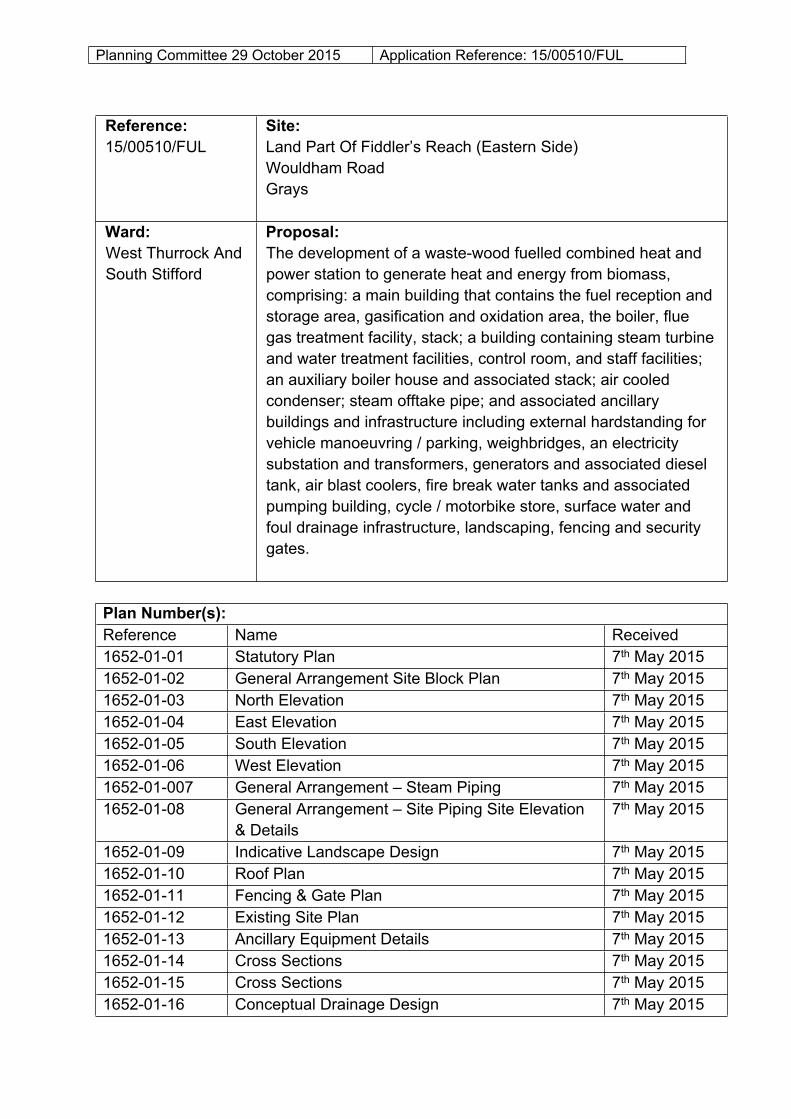
Planning Committee 29 October 2015 Application Reference: 15/00510/FUL Reference: 15/00510/FUL Site: Land Part Of Fiddler’s Reach (Eastern Side) Wouldham Road Grays Ward: West Thurrock And South Stifford Proposal: The development of a waste-wood fuelled combined heat and power station to generate heat and energy from biomass, comprising: a main building that contains the fuel reception and storage area, gasification and oxidation area, the boiler, flue gas treatment facility, stack; a building containing steam turbine and water treatment facilities, control room, and staff facilities; an auxiliary boiler house and associated stack; air cooled condenser; steam offtake pipe; and associated ancillary buildings and infrastructure including external hardstanding for vehicle manoeuvring / parking, weighbridges, an electricity substation and transformers, generators and associated diesel tank, air blast coolers, fire break water tanks and associated pumping building, cycle / motorbike store, surface water and foul drainage infrastructure, landscaping, fencing and security gates. Plan Number(s): Reference Name Received 1652-01-01 Statutory Plan 7 th May 2015 1652-01-02 General Arrangement Site Block Plan 7 th May 2015 1652-01-03 North Elevation 7 th May 2015 1652-01-04 East Elevation 7 th May 2015 1652-01-05 South Elevation 7 th May 2015 1652-01-06 West Elevation 7 th May 2015 1652-01-007 General Arrangement – Steam Piping 7 th May 2015 1652-01-08 General Arrangement – Site Piping Site Elevation & Details 7 th May 2015 1652-01-09 Indicative Landscape Design 7 th May 2015 1652-01-10 Roof Plan 7 th May 2015 1652-01-11 Fencing & Gate Plan 7 th May 2015 1652-01-12 Existing Site Plan 7 th May 2015 1652-01-13 Ancillary Equipment Details 7 th May 2015 1652-01-14 Cross Sections 7 th May 2015 1652-01-15 Cross Sections 7 th May 2015 1652-01-16 Conceptual Drainage Design 7 th May 2015
-
Upload
truongkhue -
Category
Documents
-
view
218 -
download
0
Transcript of Reference: Site: Ward: Proposal - …democracy.thurrock.gov.uk/thurrock/documents/s5853/1500510FUL...
Planning Committee 29 October 2015 Application Reference: 15/00510/FUL
Reference:15/00510/FUL
Site: Land Part Of Fiddler’s Reach (Eastern Side)Wouldham RoadGrays
Ward:West Thurrock And South Stifford
Proposal: The development of a waste-wood fuelled combined heat and power station to generate heat and energy from biomass, comprising: a main building that contains the fuel reception and storage area, gasification and oxidation area, the boiler, flue gas treatment facility, stack; a building containing steam turbine and water treatment facilities, control room, and staff facilities; an auxiliary boiler house and associated stack; air cooled condenser; steam offtake pipe; and associated ancillary buildings and infrastructure including external hardstanding for vehicle manoeuvring / parking, weighbridges, an electricity substation and transformers, generators and associated diesel tank, air blast coolers, fire break water tanks and associated pumping building, cycle / motorbike store, surface water and foul drainage infrastructure, landscaping, fencing and security gates.
Plan Number(s):Reference Name Received1652-01-01 Statutory Plan 7th May 20151652-01-02 General Arrangement Site Block Plan 7th May 20151652-01-03 North Elevation 7th May 20151652-01-04 East Elevation 7th May 20151652-01-05 South Elevation 7th May 20151652-01-06 West Elevation 7th May 20151652-01-007 General Arrangement – Steam Piping 7th May 20151652-01-08 General Arrangement – Site Piping Site Elevation
& Details7th May 2015
1652-01-09 Indicative Landscape Design 7th May 20151652-01-10 Roof Plan 7th May 20151652-01-11 Fencing & Gate Plan 7th May 20151652-01-12 Existing Site Plan 7th May 20151652-01-13 Ancillary Equipment Details 7th May 20151652-01-14 Cross Sections 7th May 20151652-01-15 Cross Sections 7th May 20151652-01-16 Conceptual Drainage Design 7th May 2015
Planning Committee 29 October 2015 Application Reference: 15/00510/FUL
1652-01-17 Control Building, Turbine Hall & Water Treatment Building Floor Plans
7th May 2015
The application is also accompanied by:
Design & Access Statement & Addendum; Planning Statement; Statement of Community Involvement; Energy Statement; BREEAM Assessment; Market Need Statement; Foul Sewage Statement; Transport Assessment; Environmental Statement - with the following chapter headings
o Introduction & Background;o Approach to Environmental Impact Assessment;o Alternatives Considered;o Scheme Description & Construction Methods;o Planning Policy Context;o Landscape & Visual Effects;o Ecology & Nature Conservation;o Air Quality & Human Health;o Noise;o Ground Conditions & Hydrogeology;o Transport & Access;o Surface Water & Flood Risk;o Grid Connection; ando Summary of Effects.
Applicant:Balfour Beatty Nexterra
Validated: 13th May 2015Date of expiry: 2nd September 2015
Recommendation: APPROVAL, subject to conditions.
1.0 DESCRIPTION OF PROPOSAL
1.1 The main elements of the proposal are summarised in the table below:
Site Area 2.8 HaBuilding Floorspace 7,255 sq.m.Building Heights Maximum 27m above ground level
Planning Committee 29 October 2015 Application Reference: 15/00510/FUL
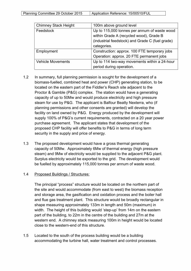
Chimney Stack Height 100m above ground levelFeedstock Up to 115,000 tonnes per annum of waste wood
within Grade A (recycled wood), Grade B (industrial feedstock) and Grade C (fuel grade) categories.
Employment Construction: approx. 100 FTE temporary jobsOperation: approx. 20 FTE permanent jobs
Vehicle Movements Up to 114 two-way movements within a 24-hour period during operation.
1.2 In summary, full planning permission is sought for the development of a biomass-fuelled, combined heat and power (CHP) generating station, to be located on the eastern part of the Fiddler’s Reach site adjacent to the Proctor & Gamble (P&G) complex. The station would have a generating capacity of up to 50Mw and would produce electricity and high pressure steam for use by P&G. The applicant is Balfour Beatty Nexterra, who (if planning permissions and other consents are granted) will develop the facility on land owned by P&G. Energy produced by the development will supply 100% of P&G’s current requirements, contracted on a 20 year power purchase agreement. The applicant states that development of the proposed CHP facility will offer benefits to P&G in terms of long term security in the supply and price of energy.
1.3 The proposed development would have a gross thermal generating capacity of 50Mw. Approximately 6Mw of thermal energy (high pressure steam) and 9Mw of electricity would be supplied to the adjacent P&G plant. Surplus electricity would be exported to the grid. The development would be fuelled by approximately 115,000 tonnes per annum of waste wood.
1.4 Proposed Buildings / Structures:
The principal “process” structure would be located on the northern part of the site and would accommodate (from east to west) the biomass reception and storage area, the gasification and oxidation process and the boiler hall and flue gas treatment plant. This structure would be broadly rectangular in shape measuring approximately 133m in length and 50m (maximum) in width. The height of this building would ‘step-up’ from 14m on the eastern part of the building, to 22m in the centre of the building and 27m at the western end. A chimney stack measuring 100m in height would be located close to the western-end of this structure.
1.5 Located to the south of the process building would be a building accommodating the turbine hall, water treatment and control processes.
Planning Committee 29 October 2015 Application Reference: 15/00510/FUL
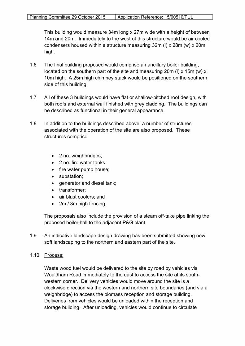
This building would measure 34m long x 27m wide with a height of between 14m and 20m. Immediately to the west of this structure would be air cooled condensers housed within a structure measuring 32m (l) x 28m (w) x 20m high.
1.6 The final building proposed would comprise an ancillary boiler building, located on the southern part of the site and measuring 20m (l) x 15m (w) x 10m high. A 25m high chimney stack would be positioned on the southern side of this building.
1.7 All of these 3 buildings would have flat or shallow-pitched roof design, with both roofs and external wall finished with grey cladding. The buildings can be described as functional in their general appearance.
1.8 In addition to the buildings described above, a number of structures associated with the operation of the site are also proposed. These structures comprise:
2 no. weighbridges; 2 no. fire water tanks fire water pump house; substation; generator and diesel tank; transformer; air blast coolers; and 2m / 3m high fencing.
The proposals also include the provision of a steam off-take pipe linking the proposed boiler hall to the adjacent P&G plant.
1.9 An indicative landscape design drawing has been submitted showing new soft landscaping to the northern and eastern part of the site.
1.10 Process:
Waste wood fuel would be delivered to the site by road by vehicles via Wouldham Road immediately to the east to access the site at its south-western corner. Delivery vehicles would move around the site is a clockwise direction via the western and northern site boundaries (and via a weighbridge) to access the biomass reception and storage building. Deliveries from vehicles would be unloaded within the reception and storage building. After unloading, vehicles would continue to circulate
Planning Committee 29 October 2015 Application Reference: 15/00510/FUL
around the site in a clockwise direction via a second weighbridge to exit the site.
1.11 Delivered waste wood from the biomass store would be screened and moved via enclosed conveyors to the gasification hall. The gasification process involves subjecting the biomass fuel to high temperatures in a reduced oxygen environment in order to create a synthetic gas (syngas). This gas is then transferred to oxidation chambers where air is introduced and the gas combusted. Hot gasses from the combustion process are transferred to a boiler to raise superheated steam. Some of this steam would be piped to provide heat to the P&G plant with the remainder of the steam transferred to the steam turbine for the generation of electricity. Spent steam from the turbine would be condensed via the air cooled condensers and recycled in the boiler.
1.12 Hot gasses would be treated and cleaned before emission to the atmosphere via the 100m high chimney stack. During periodic maintenance of the biomass plant, auxiliary boilers using natural gas would provide steam to the P&G plant. The site would be connected to the P&G plant by an overground steam pipe and an underground cable connection for electricity. The connection between the site and the national electricity grid does not form part of the planning application as the connection would be undertaken as permitted development by the network operator. However, it is likely that an underground connection would tie-into the existing 33Kv line at Hedley Avenue.
1.13 Solid by-products from the operation of the facility would comprise bottom ash and air pollution control (APC) residues. Bottom ash is the residue from the gasification of the waste wood feedstock and is an inert material which will be collected and can be used as a secondary aggregate or disposed via non-hazardous landfill. APC residues are particles of ash and residue from the flue gas treatment process. The residue would be collected and disposed in a hazardous disposal facility.
1.14 Feedstock:
The biomass feedstock for the proposed facility will be waste wood. Waste wood is graded by the wood recycling industry (and recognised by the Environment Agency’s Briefing on Regulation of Wood – September 2014) as follows:
Grade A – clean, recycled waste wood;

Planning Committee 29 October 2015 Application Reference: 15/00510/FUL
Grade B – may contain Grade A material together with other waste wood from construction and demolition, transfer stations, civic amenity sites etc.
Grade C – may contain Grade A and B material but predominantly comprises panel products such as panel board, plywood etc.
Grade D – hazardous waste wood i.e. treated wood.
The applicant would seek to source Grade B and C wood for the facility in preference to Grade A. Grade D waste wood would not be accepted at the site. The submitted Environmental Statement notes that the applicant has:
“… examined potential sources of waste wood within the region and has identified that after having taken into account other proposed biomass energy facilities that are understood to be either in development or close to the start of development, including Tilbury Green Power, there is an excess of waste wood (Grade B and C) within a 50 mile catchment of the Proposed Development that exceeds the capacity of the Proposed Development. Whilst it may still be appropriate to source wood from outside this zone, it is considered that transport costs are likely to limit the distance waste wood would be transported to the facility. On this basis it is considered likely that the majority of waste wood sourced for treatment at this facility would be from within a 50 mile distance of the Site.”
1.15 Construction / Operating Hours:
If planning permission and other consent(s) are granted, a construction period of 30 months is estimated with works between the hours of 0700-1900 on Mondays to Fridays and 0700-1200 on Saturdays. During operation, the facility would generate heat and power on a 24 hour basis, 7 days a week. Deliveries of biomass to the site would be between 0700-1900 on Mondays to Fridays and 0700-1300 on Saturdays.
2.0 SITE DESCRIPTION
2.1 The application site comprises the eastern part of the Fiddler’s Reach site located on the northern bank of the River Thames, south of the Grays – Fenchurch Street railway line and west of Wouldham Road. The application site extends to 2.8Ha in area and is broadly rectangular in shape, though it also includes the alignment of the proposed steam off-take pipeline.
2.2 The site is largely unused, apart from the south-eastern corner of the site which appears to be used for the storage of plant. There are several stockpiles of aggregate, possibly arisings from the demolition of former

Planning Committee 29 October 2015 Application Reference: 15/00510/FUL
buildings, on the remainder of the site. Historically the site was used for the manufacture of cement. An Ordnance Survey map of 1897 show the site forming part of the Lion Works (Portland Cement), with land to the east forming the Grays Portland Cement Works and the Thames Works (Portland Cement) on the site of the current P&G facility. By the early 20th century the Fiddler’s Reach site was entirely occupied by the cement works and its associated buildings, plant and railway sidings. The use of the site as a cement works, later known as the Wouldham Cement Company, ceased in the mid-1970’s after which the site was used as a storage and pre-fabrication yard for concrete casts.
2.3 The site comprises flat and low-lying land with ground levels between 4.2m and 5.2m AOD. The site is located within the high risk flood zone (Zone 3), although the site benefits from flood defences along the River Thames frontage.
2.4 The northern boundary of the site abuts the east-west railway line that links Grays with London Fenchurch Street. The railway lines branch off to Purfleet and South Ockendon close to the north-western corner of the site. The railway line is crossed by the Wouldham Road bridge adjacent to the site’s eastern boundary.
2.5 Immediately to the north of the railway line are a number of industrial units served from Gumley Road, comprising the Commodore Kitchens site and the Acorn Trading Estate. To the north of Gumley Road are Victorian terraced houses and an area of public open space which adjoins London Road. London Road runs in an east-west direction and provides the main transport connection to the wider road network, as well as bus links to Grays and Lakeside. To the north-west of the site are recently constructed and party occupied residential properties at Gumley Close and The Chase, located on the site of the former William Ball estate.
2.6 To the east of Wouldham Road is the residential area of Argent Street which extends along the north bank of the River Thames towards Grays. The junction of Wouldham Road and Argent Street is stopped up to preclude vehicular access. The Argent Street area is characterised by 2 and 3-storey brick built flats and houses arranged around a series of culs-de-sac accessed via the spine road. There is an area of landscaped open space and a footpath along the river frontage. Underground and over ground pipelines related to the Askew’s Farm NuStar Terminal petrochemical site pass adjacent to the eastern boundary of the site on a north south axis. A transfer / pumping station is also situated adjacent to this boundary of the site, on to the route of the underground pipelines.
Planning Committee 29 October 2015 Application Reference: 15/00510/FUL
2.7 The southern boundary of the site is formed by the River Thames and associated foreshore. The Thames Path Public Right of Way (PRoW) is located adjacent to the southern boundary of the site, along the mudflats of the River Thames. Currently, the application site cannot be accessed by pedestrians from the PRoW as it is fenced off. Flood defence walls are located along the site’s southern boundary with the River Thames.
2.8 To the west of the application site is the Procter and Gamble (P&G) factory complex. The P&G site is accessed by Hedley Avenue which runs to the north of the P&G factory complex and returns along the western boundary of the application site.
3.0 RELEVANT HISTORY
3.1 Historically the current Fiddler’s Reach site was as part of the Lion Works (Portland Cement works) from the 1870’s. Cement manufacturing continued on site until the mid-1970s with storage in on-site silos continuing until the early-1980s. More recently Laing O’Rourke, and associated companies, used the site primarily as a storage and prefabrication yard (Class B2 / B8 use).
3.2 The following planning history is relevant;
Reference Description Decision94/00378/FUL Building contractors depot and
headquarters (entire Fiddler’s Reach site)Withdrawn
98/00134/OUT * Outline application for offices and car parking (entire Fiddler’s Reach site)
Allowed on appeal
98/00455/FUL * Demolition of derelict industrial buildings and construction of building for precast concrete casting (entire Fiddler’s Reach site)
Allowed on appeal
* - The above two applications were subject to appeals against non-determination. The Inspector considered that neither proposal would prejudice the construction of the road link between Wouldham Road and Headley Avenue.98/00851/FUL Demolition of derelict industrial buildings
and construction of prefabricated buildings on temporary basis for precast concrete casting (entire Fiddler’s Reach site)
Approved
04/00153/OUT Erection of residential units, retail (A1, A2, A3) leisure (D2) industrial (B8), public open space and associated access including extension of Hedley Avenue and
Approved
Planning Committee 29 October 2015 Application Reference: 15/00510/FUL
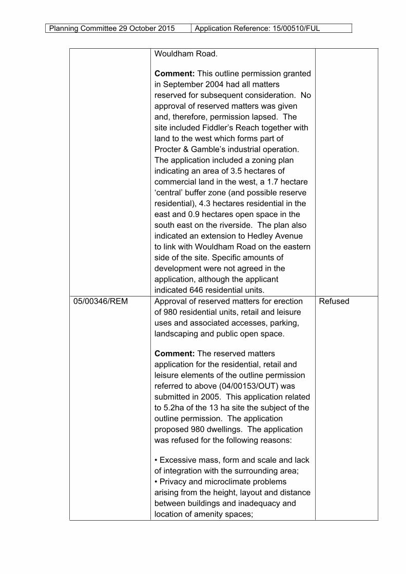
Wouldham Road.
Comment: This outline permission granted in September 2004 had all matters reserved for subsequent consideration. No approval of reserved matters was given and, therefore, permission lapsed. The site included Fiddler’s Reach together with land to the west which forms part of Procter & Gamble’s industrial operation. The application included a zoning plan indicating an area of 3.5 hectares of commercial land in the west, a 1.7 hectare ‘central’ buffer zone (and possible reserve residential), 4.3 hectares residential in the east and 0.9 hectares open space in the south east on the riverside. The plan also indicated an extension to Hedley Avenue to link with Wouldham Road on the eastern side of the site. Specific amounts of development were not agreed in the application, although the applicant indicated 646 residential units.
05/00346/REM Approval of reserved matters for erection of 980 residential units, retail and leisure uses and associated accesses, parking, landscaping and public open space.
Comment: The reserved matters application for the residential, retail and leisure elements of the outline permission referred to above (04/00153/OUT) was submitted in 2005. This application related to 5.2ha of the 13 ha site the subject of the outline permission. The application proposed 980 dwellings. The application was refused for the following reasons:
• Excessive mass, form and scale and lack of integration with the surrounding area;• Privacy and microclimate problems arising from the height, layout and distance between buildings and inadequacy and location of amenity spaces;
Refused

Planning Committee 29 October 2015 Application Reference: 15/00510/FUL
• Over-development, with the proposal exceeding maximum standards set by the Council;• Inadequate provision for vehicles, pedestrians and public transport;• Consideration of crime prevention and reduction;• Consideration of impact on air quality;• Potential adverse impacts on upstream habitats;• Lack of detail for instance relating to building materials, landscape, distribution of affordable housing, energy efficiency measures
05/00345/FUL Construction of roads, car parking and garden areas.
Comment: A full planning application was submitted for 3.1 hectares of land surrounding the reserved matters site to provide the road link between the commercial area to the west and Wouldham Road. The application was refused for the following reasons:• Substandard junction spacing and vehicle access;• Impact on air quality;• Risk of crime in the large proposed parking areas;• Lack of detail regarding noise barriers and Network Rail’s requirements.
Refused
08/00370/TTGOUT Redevelopment of site to provide up to 1,217 residential units in 13 parcels of between 2.5 to 21 storeys that will also incorporate 940m2 of local retail, leisure and community uses (Use Class A1 - Shops, A3 – Restaurants and Cafes, A4 – Drinking Establishments, D1 – Non-Residential Institutions) at ground floor level. 2,880m2 of business use (Use Classes B1 – Business, B2 – General Industry or B8 – Storage and Distribution). Formation of associated access, landscaping and remediation works.
Approved

Planning Committee 29 October 2015 Application Reference: 15/00510/FUL
Comment: In December 2009 the former Thurrock Development Corporation (DC) resolved to grant planning permission subject to referral to the Secretary of State, the completion of a s106 legal agreement and planning conditions. Following detailed negotiation on the heads of terms for the legal agreement, particularly the provision of affordable housing, the s.106 was completed and outline planning permission granted in January 2012. The permission was subject to a condition requiring submission of the first application for reserved matters within 3 years of the permission (i.e. by 9th January 2015). No applications for the approval of reserved matters have been submitted and therefore this permission has now lapsed.
4.0 CONSULTATIONS AND REPRESENTATIONS
4.1 Detailed below is a summary of the consultation responses received. Full text versions are available on the Council’s web-site at: www.thurrock.gov.uk/planning/15/00513/FUL
4.2 PUBLICITY:
The application has been publicised by the display of site notices, a newspaper advertisement and consultation with neighbouring properties. The proposals have been advertised as a major development accompanied by an Environmental Statement and as affecting a public footpath.
4.3 Neighbour consultation letters have been sent to 283 surrounding properties. 309 standard pro-forma letters have been received objecting to the application on the grounds of:
impacts on air quality and public health; no proof that the proposal accords with the waste hierarchy principle; poor design / low efficiency; and health and safety implications.
4.4 A petition containing 352 signatures objecting to the application has also
Planning Committee 29 October 2015 Application Reference: 15/00510/FUL
been received.
4.5 A letter of support has been received jointly signed by the plant manager (West Thurrock) and vice president & general manager (UK) of P&G. The contents of this letter are considered elsewhere in this report. A letter has also been received from an agent acting on behalf of NuStar Terminals Ltd. who operate the importation jetties and pipelines to the south and east of the site. This letter expresses support for the principle of the development, which is considered to comply with relevant national and local planning policies. Nonetheless, Nustar highlight the importance of maintaining the structural integrity of the pipelines and associated equipment as well as the need for unimpeded access.
4.6 ANGLIAN WATER:
No objection subject to condition.
4.7 ESSEX COUNTY COUNCIL (ARCHAEOLOGY):
No objection subject to condition.
4.8 CIVIL AVIATION AUTHORITY:
No objection. Recommend that some form of low-intensity aviation lighting is displayed at the top of the proposed chimney.
4.9 ESSEX & SUFFOLK WATER:
No objection.
4.10 HIGHWAYS ENGLAND:
No objection.
4.11 NETWORK RAIL:
Provide comments referring to the safeguarding and protection of railway assets during any construction / operational phase of the proposed development.

Planning Committee 29 October 2015 Application Reference: 15/00510/FUL
4.12 PORT OF LONDON AUTHORITY:
The applicant should give consideration to the potential use of the River Thames for both the delivery of construction materials and delivery of biomass during operation. If planning permission is granted planning conditions are recommended to require details of all external lighting and details of the proposed surface water outfall to the river.
4.13 ENVIRONMENT AGENCY:
No objection subject to planning conditions attached to any planning permission to address the issues of contaminated land flood risk.
Further advice is offered in relation to these issues as well as foul water disposal and the Environmental Permitting Regulations.
4.14 NATURAL ENGLAND:
Internationally Designated Sites – no objection. The local planning authority should have regard to potential impact from the development on the Thames Estuary and Marshes Special Protection Area, as required by the Habitats Regulations. However, Natural England advise that the proposal is unlikely to have a significant effect on any European site, and can therefore be screened out from any requirement for further assessment.
SSSI – no objection. Natural England is satisfied that the proposed development being carried out in strict accordance with the details of the application, as submitted, will not damage or destroy the interest features for which West Thurrock Lagoon and Marshes SSSI has been notified.
Protected Species – Natural England has not assessed the application for impact on protected species and refers to their published standing advice.
4.15 ENVIRONMENTAL HEALTH:
No objection subject to conditions.
4.16 FLOOD RISK MANAGER:
No objection subject to conditions.
Planning Committee 29 October 2015 Application Reference: 15/00510/FUL
4.17 HIGHWAYS:
No objections – subject to planning conditions requiring details of the access road arrangements, a weekly limit on the number of HGV movements and the submission, approval and implementation of a CEMP.
4.18 DARTFORD BOROUGH COUNCIL:
No observations.
4.19 GRAVESHAM BOROGH COUNCIL:
No objection.
4.20 LANDSCAPE & ECOLOGY:
Ecology – No objections.
Landscape –There are no sufficient grounds to object to this development on landscape and visual grounds.
4.21 PUBLIC RIGHTS OF WAY:
Request that the possible upgrade of footpath no.170 to a joint footpath / national cycle route is investigated.
4.22 BRITISH PIPELINE AGENCY:
No objection.
5.0 POLICY CONTEXT
5.1 National Planning Policy Framework
The NPPF was published on 27th March 2012. Paragraph 13 of the Framework sets out a presumption in favour of sustainable development. Paragraph 196 of the Framework confirms the tests in s.38 (6) of the Planning and Compulsory Purchase Act 2004 and s.70 of the Town and Country Planning Act 1990 and that the Framework is a material consideration in planning decisions. Paragraph 197 states that in assessing and determining development proposals, local planning authorities should apply the presumption in favour of sustainable development.
Planning Committee 29 October 2015 Application Reference: 15/00510/FUL
The following headings and content of the NPPF are relevant to the consideration of the current proposals.
1. Building a strong, competitive economy4. Promoting sustainable transport7. Requiring good design8. Promoting healthy communities10. Meeting the challenge of climate change, flooding and coastal change11. Conserving and enhancing the natural environment
5.2 National Waste Policy
The following documents are relevant to this case:
National Planning Policy for Waste (2014); Waste Management Plan for England (2013)
5.3 National Energy Policy
The following documents are relevant to this case:
Overarching National Policy Statement for Energy EN-1 (2011);National Policy Statement for Renewable Energy Infrastructure EN-3 (2011)
5.4 Planning Practice Guidance (PPG)
In March 2014 the Department for Communities and Local Government (DCLG) launched its planning practice guidance web-based resource. This was accompanied by a Written Ministerial Statement which includes a list of the previous planning policy guidance documents cancelled when the NPPF was launched. PPG contains 42 subject areas, with each area containing several sub-topics. Those of particular relevance to the determination of this planning application comprise:
Air quality Climate change Design Environmental Impact Assessment Flood Risk and Coastal Change Health and wellbeing
Planning Committee 29 October 2015 Application Reference: 15/00510/FUL
Land affected by contamination Light pollution Natural Environment Noise Open space, sports and recreation facilities, public rights of way and
local green space Planning obligations Renewable and low carbon energy Travel plans, transport assessments and statements in decision-taking Use of Planning Conditions Waste Water supply, wastewater and water quality
5.5 Local Planning Policy
Thurrock Local Development Framework (2011)
The Council adopted the “Core Strategy and Policies for the Management of Development Plan Document” in December 2011. The Adopted Interim Proposals Map shows the majority of the site as falling within a Primary Industrial and Commercial Area, with a small part of the south of the site identified as additional open space. The Proposals Map also shows the indicative position of a new road aligned east-west through the site. The following Core Strategy policies apply to the proposals:
SPATIAL POLICIES - CSSP1: Sustainable Housing and Locations- CSSP2: Sustainable Employment Growth- CSSP3: Sustainable Infrastructure- CSSP5: Sustainable Greengrid- OSDP1: Promotion of Sustainable Growth and Regeneration in
Thurrock1
THEMATIC POLICIES - CSTP1: Strategic Housing Provision- CSTP6: Strategic Employment Provision- CSTP14: Transport in the Thurrock Urban Area: Purfleet to Tilbury3
- CSTP15: Transport in Greater Thurrock- CSTP16: National and Regional Transport Networks3
- CSTP17: Strategic Freight Movement and Access to Ports- CSTP18: Green Infrastructure- CSTP19: Biodiversity
Planning Committee 29 October 2015 Application Reference: 15/00510/FUL
- CSTP20: Open Space- CSTP22: Thurrock Design- CSTP23: Thurrock Character and Distinctiveness2
- CSTP25: Addressing Climate Change2
- CSTP26: Renewable or Low-Carbon Energy Generation2
- CSTP27: Management and Reduction of Flood Risk2
- CSTP28: River Thames2
- CSTP29: Waste Strategy- CSTP30: Regional Waste Apportionment- CSTP33: Strategic Infrastructure Provision
POLICIES FOR MANAGEMENT OF DEVELOPMENT- PMD1: Minimising Pollution and Impacts on Amenity2
- PMD2: Design and Layout2- PMD3: Tall Buildings3
- PMD7: Biodiversity, Geological Conservation and Development2- PMD8: Parking Standards3
- PMD9: Road Network Hierarchy- PMD10: Transport Assessments and Travel Plans2
- PMD11: Freight Movement- PMD13: Decentralised, Renewable and Low Carbon Energy Generation- PMD15: Flood Risk Assessment2- PMD16: Developer Contributions2
[Footnote: 1New Policy inserted by the Focused Review of the LDF Core Strategy. 2Wording of LDF-CS Policy and forward amended either in part or in full by the Focused Review of the LDF Core Strategy. 3Wording of forward to LDF-CS Policy amended either in part or in full by the Focused Review of the LDF Core Strategy].
5.6 Focused Review of the LDF Core Strategy (2014)
This Review was commenced in late 2012 with the purpose to ensure that the Core Strategy and the process by which it was arrived at are not fundamentally at odds with the NPPF. There are instances where policies and supporting text are recommended for revision to ensure consistency with the NPPF. The Review was submitted to the Planning Inspectorate for independent examination in August 2013. An Examination in Public took place in April 2014. The Inspector concluded that the amendments were sound subject to recommended changes. The Core Strategy and Policies for Management of Development Focused Review: Consistency with National Planning Policy Framework Focused Review was adopted by Council on the 28th February 2015.
Planning Committee 29 October 2015 Application Reference: 15/00510/FUL
5.7 Draft Site Specific Allocations and Policies DPD
This Consultation Draft “Issues and Options” DPD was subject to consultation commencing during 2012. The Draft Site Specific Allocations DPD ‘Further Issues and Options’ was the subject of a further round of consultation during 2013. The application site has the following allocations within both of these draft documents:
Policy SAP1 – Land for housing development with planning permission Policy SAP8 – Proposed additional retail areas / sites; SAP12 – Proposed health facilities; SAP14 – Local transport schemes.
The Planning Inspectorate is advising local authorities not to continue to progress their Site Allocation Plans towards examination whether their previously adopted Core Strategy is no longer in compliance with the NPPF. This is the situation for the Borough.
5.8 Thurrock Core Strategy Position Statement and Approval for the Preparation of a New Local Plan for Thurrock
The above report was considered at the February 2014 meeting of the Cabinet. The report highlighted issues arising from growth targets, contextual changes, impacts of recent economic change on the delivery of new housing to meet the Borough’s Housing Needs and ensuring consistency with Government Policy. The report questioned the ability of the Core Strategy Focused Review and the Core Strategy ‘Broad Locations & Strategic Sites’ to ensure that the Core Strategy is up-to-date and consistent with Government Policy and recommended the ‘parking’ of these processes in favour of a more wholesale review. Members resolved that the Council undertake a full review of Core Strategy and prepare a new Local Plan.
6.0 ASSESSMENT
6.1 Procedure:
The development proposal is considered to be a development requiring Environmental Impact Assessment (EIA), therefore the application has been accompanied by an Environmental Statement (ES). The ES considers the environmental effects of the proposed development during construction and operation and includes measures to either prevent, reduce or offset
Planning Committee 29 October 2015 Application Reference: 15/00510/FUL
any significant adverse effects on the environment. The ES is accompanied by technical appendices. The contents of the EA comprise:
1. Introduction and background2. Approach to the EIA3. Alternatives considered4. Scheme description and construction methods5. Planning policy context6. Landscape and visual effects7. Ecology and nature conservation8. Air quality and human health9. Noise10. Ground conditions and hydrogeology11. Transport and access12. Surface water and flood risk13. Grid connection.
6.2 The Council has a statutory duty to consider environmental matters and an EIA is an important procedure for ensuring that the likely effects of new development are fully understood and fully taken into account before development proceeds. EIA is, therefore, an integral component of the planning process for significant developments. EIA leads to improved decision making by providing the development management process with better information. EIA not only helps to determine whether development should be permitted but also facilitates the drafting of planning conditions and legal agreements in order to control development, avoid or mitigate adverse effects and enhance beneficial effects. Therefore, it is vital that the environmental issues raised by the application are assessed in a robust and transparent manner.
6.3 In order to fulfil the requirements of the EIA Regulations it is necessary to ensure (a) that the Council has taken into account the environmental information submitted, and (b) that any planning permission granted is consistent with the development which has been assessed. To achieve this second objective the Council has the ability to impose conditions and secure mitigation measures by Section 106 obligations.
6.4 The principal issues for consideration in this case relate to:
I. Development Plan allocation and the principle of development;II. Site layout;
III. Design, landscape and visual impact;IV. Transport, traffic and access;

Planning Committee 29 October 2015 Application Reference: 15/00510/FUL
V. Ecology and nature conservation;VI. Air quality;
VII. Noise;VIII. Ground conditions and contamination; and
IX. Flood risk and surface water drainage;
I. DEVELOPMENT PLAN ALLOCATION AND THE PRINCIPLE OF THE DEVELOPMENT
6.5 Employment Policy:
The application site is identified on the Core Strategy LDF Adopted Interim Proposals Map as a Primary Industrial and Commercial Area where policies CSSP2 and CSTP6 apply. Policy CSSP2 (Sustainable Employment Growth) states that the Council will promote and support economic development in the Key Strategic Employment Hubs (including Lakeside Basin / West Thurrock) that seeks to expand upon their existing core sectors and / or provide opportunities in the growth sectors.
6.6 Policy CSTP6 (Strategic Employment Provision) states, inter-alia, that in the Primary and Secondary Industrial and Commercial Areas:
I. the Council will safeguard existing Primary and Secondary Industrial and Commercial land and premises in, or last used for employment purposes, where it is required to maintain a sufficient supply of employment land in the Plan period;
III. The Primary and Secondary Industrial and Commercial areas will be reserved for employment generating uses falling within Class B1, B2, and B8 and sui generis uses. The Council will consider economic development that includes non-B Class uses within the Primary and Secondary Industrial and Commercial areas provided that it meets the following:
(i) the non-B Class Use provides a complementary and supporting use for the existing Class B uses; or
(ii) the non-B Class Use is necessary for the day-to-day service requirements of the existing Class B uses; or
(iii) there is a demonstrable need for the non-B Class Use within the Borough and there are no other reasonable alternative sites within the Borough; and
Planning Committee 29 October 2015 Application Reference: 15/00510/FUL
(iv) the introduction of the non-B Class Use will not compromise the supply of Class B land within the Borough and will not adversely affect Thurrock’s existing and future economic structure;
6.7 In this case, the proposed use of the application site as a biomass-fuelled, combined heat and power station is akin to a sui-generis use. However, the proposal would provide both a complementary and supporting use and for the day-to-day requirements for an existing Class B use in that the proposal would provide heat and power to the adjacent P&G facility. The proposal is therefore consistent with III (i) and (ii) of Policy CSTP6.
6.8 The key objective of CSTP6 is to provide for economic and employment growth. The applicant estimates that 20 FTE jobs will be created during the operation of the facility. Given the new net floorspace proposed (7,255 sq.m.), this number of jobs is below the employment density which could reasonably be expected for a Class B2 or Class B8 development. On the basis of 7,255 sq.m. floorspace the Employment Densities Guide 2010 (Homes & Communities Agency) suggests the potential generation of up to 120 jobs if the building were in Class B2 use and up to 63 jobs for a Class B8 use. The employment created by the proposal is therefore disappointing compared with conventional industrial and warehousing employment densities.
6.9 Nevertheless, it is relevant to consider the relationship between the development and the adjacent P&G plant. A letter supporting the planning application has been submitted by P&G which notes that, although the company are not the named applicant, they own the Fiddler’s Reach site and will be the “ultimate beneficiary of the energy the biomass CHP will produce”. The supporting letter goes on to state:
“P&G is keen to develop, improve and invest in its existing site in Thurrock. The facility must continue to be modernised and become more eco-friendly in order to secure the long term future of P&G as a major employer in Thurrock … building this biomass CHP plant will not only create jobs for the local area but also improve the environment and secure our future in Thurrock for years to come. It will also help the sustainability of future plans for growth on the P&G Thurrock plant … we intend to create a long term contract with them (the applicant) to supply P&G with the energy produced by this plant. The planned contract will cover a period of 20 years with an expectation that this will be extended in years to come … (the location of the proposed plant) has been selected to maximise the potential for the expansion of the existing P&G plant without presenting any barriers for future use of the remainder of the Fiddler’s Reach site … we will be

Planning Committee 29 October 2015 Application Reference: 15/00510/FUL
bringing forward our plans for the space between the existing P&G plant and the proposed biomass CHP plant at the appropriate time.”
6.10 The applicant’s Planning Statement makes clear that the development will provide heat and power to the adjoining P&G plant, which is a high energy user. Although the contract between the applicant and P&G for the supply of heat and power is a commercial matter between the two parties, there are clearly potential benefits to P&G in terms of long-term security of energy supply. In September 2015 P&G announced a corporate intention to reduce greenhouse gas emissions from its facilities by 30% by 2020. The supply of renewable energy to the plant as proposed could contribute towards this objective. In recently acquiring the Fiddler’s Reach site (including the current application site) it could be argued that P&G has effectively ‘safeguarded’ the site for potential future expansion. Although the West Thurrock site will no doubt be in competition for investment with other P&G plants elsewhere in the UK and across Europe, the proposals will improve the sustainability and energy security of the site. Consequently, the proposal can supported, in adopted planning policy terms, as enhancing the potential for future commercial investment at the Fiddlers Reach site.
6.11 LDF Site Specific Allocations and Policies Local Plan – Housing:
The planning history section of this report, set out above, refers to an outline planning permission for residential redevelopment of the Fiddler’s Reach site dating from January 2012 (ref. 08/00370/TTGOUT). On the basis of this planning permission the site was identified in both the 2012 and 2013 consultation drafts of the Site Specific Allocations and Policies DPD (SSAPDPD) as a housing site with planning permission and with delivery likely in years 6-10.
6.12 Despite the emerging residential allocation for the site in the SSAPDPD, the outline planning permission was subject to a condition requiring the submission of the first application for the approval of reserved matters within three years from the outline consent. This deadline expired in January 2015 without the submission of any reserved matters and consequently the outline planning permission for residential development on Fiddler’s Reach has lapsed. When the outline planning application was submitted in 2008 the Fiddler’s Reach site was promoted for residential use by the applicant (Family Mosaic), as well as the former Thurrock Development Corporation (TTGDC) and the former East of England Development Agency (EEDA). Despite investment from public bodies (TTGDC & EEDA) in attempting to bring forward a residential development, no progress was made following the outline planning permission.
Planning Committee 29 October 2015 Application Reference: 15/00510/FUL
6.13 The difficulties in bringing forward residential development on the Fiddler’s Reach site are partly evident in the delays in finalising the s.106 agreement accompanying the outline planning permission. The outline planning application was originally considered by the TTGDC Planning Committee in December 2009 and a first draft of the s.106 was circulated in March 2010. The applicant subsequently sought amendments to the affordable housing obligations and a further report was presented to TTGDC’s Planning Committee in May 2010. Further update reports were presented to Committee in April, October and November 2011, which noted the applicant’s view that “difficult market conditions and financial viability issues” were delaying the completion of the s.106. The agreement was eventually completed in November 2011 nearly two years after the original resolution to grant planning permission. As noted above, since the grant of outline planning permission three years have elapsed with no submission of any applications for approval of reserved matters. In light of this background, the ability of the Fiddler’s Reach site to deliver residential development is clearly very doubtful. On the matter of financial viability, anecdotal evidence suggests that when the Fiddler’s Reach site was marketed in early 2015 offers from prospective purchasers for commercial uses exceeded the value for residential use and furthermore appears to have been limited interest from residential developers.
6.14 In light of the above considerations, it is not considered that an objection could be sustained to the loss of a potential residential site as identified in the draft SSAPDPD.
Adopted LDF Climate Change Thematic Policies – CSTP26:
6.15 Core Strategy Policy CSTP26 (Renewable or Low-Carbon Energy Generation – as amended by the Focused Review of the LDF) generally encourages opportunities to generate energy from non-fossil fuel and low-carbon energy sources. Part II of this policy states that the Council will promote the delivery of renewable and low-carbon energy development utilising technology such as biomass and combined heat and power. The proposals would supply the adjacent P&G plant with heat and power generated from renewable sources which could make a significant contribution for carbon reduction and enhance the sustainability of an important industrial facility in the Borough. Compliance with this Core Strategy policy is a positive factor which weighs in favour of the proposals.
Planning Committee 29 October 2015 Application Reference: 15/00510/FUL
National Policy & Policy Statements for Energy:
6.16 The ‘Overarching National Policy Statement for Energy’ (EN-1 (2011)), although specifically applying to nationally significant energy infrastructure, is nevertheless likely to be a material consideration in decision making on applications that fall under the Town and Country Planning Act 1990 and therefore is relevant to this case. This document sets out the Government’s key goals on carbon emission reductions, energy security and affordability. Paragraph 3.3.10 of EN-1establishes the need for more electricity capacity to support an increased supply from renewable and states:
“ … the Government is committed to increasing dramatically the amount of renewable generation capacity. In the short to medium term, much of this new capacity … may include plant powered by the combustion of biomass …”
6.17 Paragraph 3.4 of EN-1 refers more specifically to the role of renewable electricity generation and states that biomass is a significant source of renewable and low carbon energy. EN-1 refers to the “urgency of need for new renewable electricity generation” (paragraph 3.4.5) and notes that to meet the UK’s commitments to sourcing 15% of energy from renewable sources by 2020:
6.18 “ … it is necessary to bring forward new renewable electricity generating projects as soon as possible. The need for new renewable electricity generation projects is therefore urgent.”
6.19 EN-1 also considers combined heat and power (CHP) and notes that in conventional thermal generating stations, the heat raised to drive electricity generation is subsequently emitted as waste. Supplying steam direct to industrial customers or using lower grade heat, such as in district heating networks, can reduce the amount of fuel otherwise needed to generate the same amount of heat and power separately. Using less fuel to generate the same amount of heat and power reduces emissions, particularly CO2 and the Government has therefore committed to promoting CHP.
6.20 The National Policy Statement for Renewable Energy Infrastructure (EN-3 (2011)) notes at paragraph 2.5.1 that the combustion of biomass for electricity generation is likely to play an increasingly important role in meeting the UK’s renewable energy targets.
6.21 Chapter 10 of the NPPF addresses ”Meeting the challenge of climate change, flooding and coastal change” and paragraph 93 states that “planning plays a key role in … supporting the delivery of renewable and
Planning Committee 29 October 2015 Application Reference: 15/00510/FUL
low carbon energy and associated infrastructure. This is central to the economic, social and environmental dimensions of sustainable development.” Paragraph 97 refers to the increased use of renewable and low carbon energy and the recognition by local planning authorities of “the responsibility of all communities to contribute to energy generation from renewable and low carbon sources”. Finally, paragraph 98 of the NPPF states that, when determining planning applications, local planning authorities should:
not require applicants for energy development to demonstrate the overall need for renewable or low carbon energy and also recognise that even small-scale projects provide a valuable contribution to cutting greenhouse gas emissions; and
approve the application(unless material considerations indicate otherwise) if its impacts are (or can be made) acceptable.
6.22 The proposals are considered to be consistent with the intentions of national policy for energy as set out above.
6.23 Planning Policies for Waste:
Policies CSTP29 and CSTP30 of the Core Strategy (2011) set out the Council’s thematic policies addressing waste strategy and regional waste apportionment.
6.24 CSTP29 (Waste Strategy) states that (inter-alia):
1. the Council will seek to drive waste management up the waste hierarchy;
2. provision will only be made for total waste management capacity equivalent to the requirements for Thurrock, including imports, as set out in the Core Strategy (Tables 5, 6 and 7) or latest capacity requirements as identified through an update of the regional or local data as a result of a review of the LDF; and
3. to meet this provision, the Council will identify 1 or 2 strategic sites for the co-location of a range of waste management activities within the broad locations of Tilbury – Purfleet and the London Gateway area as identified on the key diagram.
Planning Committee 29 October 2015 Application Reference: 15/00510/FUL
6.25 It is considered that the proposals satisfy the first element of Policy CSTP29 as waste wood would be managed as high up the waste hierarchy as is possible for the type of biomass feedstock proposed.
6.26 The second element of CSTP29, referred to above, seeks to restrict waste management capacity within identified waste forecasts over the LDF plan period. The waste management capacities are identified in tables accompanying the Policy which refer to municipal solid waste and commercial and industrial waste. However, waste wood is not assessed by the policy as an individual waste stream. Data within the tables accompanying the policy is based upon an assessment dating from 2010 which has not been updated. The intentions of this part of CSTP29 must also be seen in the context of more up to date national planning policies for waste which are considered below.
6.27 The final element of policy CSTP29 referred to above identifies the broad locations of Tilbury-Purfleet and London Gateway as suitable for waste management activities. The policy goes on to state that these sites will be located within appropriate employment and industrial/port locations and will be identified in the Minerals and Waste DPD (MWDPD) and identified in the Proposals Map. Work to progress the MWDPD has been suspended, nevertheless the application site comprises an industrial / commercial area within the broad Tilbury-Purfleet location. Consequently the proposals satisfy this element of the policy.
6.28 Policy CSTP30 (Regional Waste Apportionment) sets out the ‘Strategic Approach to London’s Imports’ and largely refers to waste imports to landfill. However, the policy recognises that the former East of England Plan (RSS) does not totally discourage the provision of non-landfill waste management facilities for waste predominantly originating outside of the region. However, any proposed facility will need to be proven to be of regional significance and there is some benefit to the recovery of localised waste arisings in order to meet the local recovery targets.
6.29 It is concluded that the proposals partially comply with the intentions of Core Strategy policies CSTP29 and CSTP30.
6.30 The above Core Strategy waste policies were devised against the background of the Regional Spatial Strategy (RSS) for the East of England (East of England Plan) and policy WM3 of that Plan in particular. The Committee may recall that the RSS was revoked by the Government in 2013 and therefore, the policies upon which Core Strategy policies CSTP29 and CSTP30 were based no longer exist. Members will also be aware that in February 2015 Council considered a report titled ‘Adoption of Thurrock
Planning Committee 29 October 2015 Application Reference: 15/00510/FUL
Core Strategy and Policies for Management of Development Focused Review: Consistency with National Planning Policy Framework’. This report listed a number of Core Strategy policies to which amendments could be taken forward to ensure consistency with the NPPF without the need to prepare additional evidence. Policies CSTP29 and 30 are not on this list and remain unchanged by the Focused Review. Consequently, it cannot be assumed that the policies are compliant with the NPPF, which post-dated the adoption of the Core Strategy.
6.31 National Planning Policies for Waste:
National Planning Policy for Waste (2014) sets out the Government’s ambition to work towards a more sustainable and efficient approach to resource use and management. The Policy notes that positive planning plays a pivotal role in delivery through inter-alia “ … provision of modern infrastructure …”. When determining planning applications, planning authorities should, inter-alia:
only expect applicants to demonstrate the quantitative or market need for new or enhanced waste management facilities where proposals are not consistent with an up-to-date Local Plan.
6.32 Planning Practice Guidance emphasises the responsibility on all local planning authorities to drive waste management up the waste hierarchy. Driving waste up the waste hierarchy is also an integral part of the Waste Management Plan for England (2013). This document is capable of being a material consideration in decisions on planning applications for waste management facilities. The Waste Management Plan expresses the Government’s support for “ … efficient energy recovery from residual waste – of materials which cannot be reused or recycled - to deliver environmental benefits, reduce carbon impact and provide economic opportunities …”
6.33 Under this heading it is concluded that the proposal is consistent with national planning policies for waste management.
II. SITE LAYOUT
6.34 The application site area totals approximately 2.8 hectares in area and occupies the easternmost part of the Fiddler’s Reach site, which totals some 8.6 hectares in area. Development of the site as proposed would leave a residual area some 5.8 hectares located between the P&G site and
Planning Committee 29 October 2015 Application Reference: 15/00510/FUL
the proposed CHP facility. As noted above, P&G acquired the entire Fiddler’s Reach site earlier this year.
6.35 The general location of the proposal at the eastern-end of the Fiddler’s Reach site places the CHP facility close to existing residential dwellings located at Hastings Close and Argent Street. The detailed implications of this relationship with regard to impact on amenity are considered later in this report. However, the applicant’s Planning Statement notes that the proposed location of the CHP facility potentially allows the P&G plant to expand “seamlessly from the existing manufacturing plant, reducing overall costs”. Although there is no masterplan drawing indicating how the P&G plant could extend to the east, there are likely to be operational benefits to P&G expand in the future onto vacant land immediately adjoining the plant. The location of a CHP facility on the western part of the Fiddler’s Reach site, although increasing separation to dwellings at Hastings Close and Argent Street, would place the facility close to recently constructed dwellings at Gumley Road to the north of the railway line. Siting the CHP facility at the western-end of the Fiddler’s Reach site would also require any future expansion of the P&G plant to ‘leap-frog’ to the east. The proposed siting of the CHP facility therefore offers operational advantages should the P&G plant expand in the future.
6.36 As noted above, existing residential uses adjoin the site to the east. On the northern side of the railway line, to the north and north-east of the application site, planning permission has historically been granted for residential redevelopment of commercial sites. To the north-east, planning permission was granted for redevelopment of the motor repair depot on Wouldham Road with 66 dwellings in 2006 (ref. 05/01238/TTGOUT). Following the approval of reserved matters a further application seeking permission to extend the time limit for implementation was approved in 2010 (ref. 10/50202/TTGETL). This most recent permission requires the commencement of development by 16th December 2015. As there have been no submissions to approve pre-commencement planning conditions, it seems unlikely that this planning permission will be implemented.
6.37 To the north of the site, outline planning permission for residential development was granted in 2005 for the site of Commodore Kitchens and the Acorn Trading Estate at Gumley Road. Reserved matters approval was granted in 2009 and an application to extend the time limit for implementation (ref. 10/50240/TTGETL) was granted in 2012, requiring commencement of development by January 2017. As above, there have been no submissions to approve pre-commencement conditions and it is doubtful whether this permission will be implemented. The nearest
Planning Committee 29 October 2015 Application Reference: 15/00510/FUL
neighbouring sites to the north and north-east of the site therefore remain in commercial use.
6.38 The application site plan has been drawn to include the alignment of the steam off-take pipe which will deliver heat to the P&G plant. The pipe will emerge from the south-western corner of the cluster of plant buildings and run parallel to the alignment of the flood defence adjacent to the river frontage. The pipe would generally be at ground level, aside from a high level section above the site’s internal roadway. However, the alignment of the pipe parallel with the river ensures that land-take is minimised.
6.39 The P&G plant is designated as a major hazard site by the Health and Safety Executive (HSE) due to the storage of hazardous substances. However, the current application site lies outside of the consultation distances drawn around the hazard site. Accordingly, there is no need to interrogate the proposals via HSE’s PADHI consultation system and this matter does not constrain the determination of the planning application.
6.40 The site description, set out above, notes the presence of existing pipelines within and adjacent to the southern and eastern boundaries of the site associated with the NuStar Terminals Ltd site at Askew’s Farm. These pipelines link the two river jetties south of the Fiddler’s Reach site to Askew’s Farm, where refined oil products (diesel, gas oil, kerosene, gasoline and ethanol) are stored. The pipelines run underground, though they do emerge above ground level adjacent to the north-eastern corner of the site to cross the railway line via a pipe-bridge. These pipelines do not appear as major hazard pipelines on the consultation zone library produced by the HSE. A pumping station compound associated with the pipelines is located immediately adjacent to the eastern boundary of the application site. NuStar Terminals Ltd have been notified of the planning application but have not replied to date.
6.41 In responding to the previous residential proposals for the Fiddler’s Reach and Commodore Kitchen sites, NuStar commented that the integrity of the pipelines must be protected during both construction and operation of any development at Fiddler’s Reach and drew attention to wayleaves safeguarding the pipelines.
6.42 None of the pipelines located south of the proposed development are affected by the proposals, being located outside the application site. The pipelines to the east are partly located within the application site. However, none of the proposed buildings directly affect the pipelines and an indicative landscaping plan shows the pipelines running through an ‘oil pipeline corridor’ which will be soft landscaped. Compliance with the wayleaves
Planning Committee 29 October 2015 Application Reference: 15/00510/FUL
applying to the pipeline corridor is a private matter between NuStar and the applicant and the presence of the pipelines does not fetter the local planning authority from determining the application.
6.43 The proposed layout of the site is generally based around the plant and buildings required to process the feedstock and produce heat and power. The largest building would be located on the northern part of the site, aligned parallel with the railway line, and would accommodate biomass reception / storage, gasification / oxidation processes and the boiler hall. A smaller building housing the control room, turbine hall and water treatment process is located to the south. A number of ancillary structures comprising firewater tanks, pumphouse, air cooled condensers, auxiliary boiler, electrical substation and transformer are generally located on the southern part of the site. The height of the proposed buildings and structures generally decreases across the site from north to south and from west to east. The visual impacts of the development are considered later in this report. The layout incorporates a one-way loop arrangement for HGV’s entering and leaving the site at its south-western corner. A separate access for car would be positioned approximately half-way along the southern frontage.
III. DESIGN, LANDSCAPE AND VISUAL IMPACT
6.44 The dimensions and envelope of the three main buildings proposed is strongly influenced by the processes which will be undertaken and the process equipment required to generate heat and power. The applicant’s Design and Access Statement Addendum sets out a premise that the proposed buildings are as volumetrically efficient as they can be, that is, the buildings are intended to neatly ‘wrap-around’ the processes associated with the facility.
6.45 The proposed buildings and structures on-site can be described as large-scale, with the key dimensions summarised in the table below:
Building / Structure Length Width Height(a.g.l.))
Biomass reception / gasification / boiler hall
131m 55m (max.) 14m / 22m / 27m
Control / turbine / water treatment building
34m 27m 14m / 20m
Air cooled condensers 32m 28m 20mAuxiliary boiler building 20m 15m 10mFire-water tanks (x2) 8m

Planning Committee 29 October 2015 Application Reference: 15/00510/FUL
Fire-water pump house 6m 4m 3mSubstation 11m 10m 3mTransformer 5m 4m 2mGenerator 9m 2m 3mAir blast coolers (x2) 8m 3m 2mBoiler hall stack 100mAuxiliary boiler building stack 25m
6.46 In the context of the P&G plant buildings and plant located to the west, the proposals can be generally considered to be of a similar mass, bulk and appearance. Indeed the P&G warehouse building located at the eastern-end of the P&G facility is a maximum of c.42m high with a gross floorspace greater than that associated with the current proposals. There are also a number of emissions stacks at the P&G facility up to 76m in height. The general appearance of the P&G plant, as seen from the north and east, is that of an industrial and warehousing complex with buildings generally with flat or low-pitched roof forms and walls finished with grey-coloured cladding.
6.47 The elevations of the proposed buildings would replicate the general appearance of buildings at the P&G plant comprising flat and shallow-pitched roof forms, with both walls and roofs externally finished with grey cladding in two tones. Following the submission of the planning application Officers invited the applicant to formulate proposals to enliven and articulate the proposed mass of the buildings. In response the applicant has appointed a design consultant, with experience in energy projects, to produce an addendum to the Design and Access Statement. The addendum explores different options for the use of cladding to minimise the visual impact of the proposed buildings as seen from viewpoints to the north, north-east and south-east, though using the two-tones of grey originally proposed. Three options are promoted by the Addendum for the large buildings on-site and two options for the office element of the control building. It is considered that the options successfully break-up the mass of the buildings and represent an improvement on the submitted elevation drawings.
6.48 Given the history of the Fiddler’s Reach site, it is also relevant to consider the appearance and visual impact of the proposals in the context of former uses. As noted above, the site was historically used as a cement works and most recently as a storage and pre-fabrication yard for concrete casts. Substantial buildings and plant associated with these operations were present on-site until 2012 when the site was cleared. It is considered that the proposals are compatible with the scale and appearance of the P&G plant to the west.
Planning Committee 29 October 2015 Application Reference: 15/00510/FUL
6.49 With reference to the Thurrock Landscape Capacity Study (2005), which defines a number of landscape character areas (LCAs), the application site lies close to the boundary separating the West Thurrock & Purfleet Urban Area LCA and the Grays & Chadwell St. Mary LCA. The Council’s landscape and ecology advisor considers that the site most directly relates to the West Thurrock & Purfleet Urban Area LCA which displays the key characteristics of “large modern factory buildings … large commercial buildings … and … the strong influence of associated utilities infrastructure”. The ES includes a landscape and visual impact assessment (LVIA) which concludes that the development would not have a significant effect on landscape character. Within the context of industrial and commercial uses located upstream from the site it is agreed that the proposals would not be out of character with the key landscape characteristics of the West Thurrock & Purfleet Urban Area LCA.
6.50 To the east of the site is the Grays & Chadwell St. Mary LCA, within which suburban residential development forms a key characteristic of the landscape. Since the designation of this LCA in 2005, the residential character has been further strengthened by the redevelopment of former commercial uses at Gumley Road to the north of the railway line. The LVIA considers visual impact from a number of public viewpoints surrounding the site, including views from public vantage points at residential locations north and east of the site. Of the 9 assessed viewpoints, the LVIA concludes that visual impact is significantly adverse from 2 locations (the Thames Path south of Argent Street south-east of the site and from the Gumley Road play area north of the site). As seen from the Thames Path south of Argent Street, the proposals would add large-scale industrial buildings to foreground views and the influence of industry from this vantage point would be increased. As seen from the Gumley Road play area north of the site the development would add large-scale buildings to the skyline resulting in a significant adverse impact. As seen from the remaining assessed viewpoints at greater distances from the site, the development would be visible on the horizon from a number of vantage points.
6.51 Although the visual impact of the proposals from the Thames Path and Gumley Road play area are assessed as significantly adverse, this impact should be considered in the context of existing large scale buildings at the P&G plant and the former uses of the site. Steps have been taken to minimise visual impact, as seen from viewpoints to the east, in that the height of proposed buildings reduces from west to east across the site. Nevertheless, due to the scale of the buildings and plant, the development cannot be fully screened by new landscape planting. Soft landscaping proposals include a new native tree belt adjacent to the northern boundary
Planning Committee 29 October 2015 Application Reference: 15/00510/FUL
of the site, which would partially screen views from the open space to the north and future housing at the Commodore Kitchens / Acorn Trading Estate site (should they be constructed). However, due to the presence of the pipeline easements located on and adjacent to the eastern boundary, only grassland / scrub planting can be provided.
6.52 Comments received from the Council’s landscape and ecology advisor confirm the findings of the LVIA that the development would have significant visual impacts from the 2 viewpoints identified above. However, it is noted that the site has until recently been used for industrial uses and the scale of the proposed buildings and plant is not out of character with commercial uses to the west. It is considered therefore, as a matter of judgement, that there are insufficient grounds to object to the application on the grounds of landscape and visual impact.
6.53 With reference to impact on the visual amenities of private occupiers, the closest residents to the site are located to the east at Argent Street and Hastings Close. Waterside (Argent Street) and nos. 19 and 24 Hastings Close have flank walls, containing no window openings, facing westwards towards the application site. The nearest proposed building is the biomass reception and store which would be located between 52m and 74m from these neighbouring flank walls. Given the absence of windows in these properties facing directly towards the site there would be no significant visual impact. Nos. 21 and 23 Hasting Close have rear walls and rear garden areas which face towards the site in a westerly direction, with a minimum separation of approximately 77m between the nearest proposed building and the neighbouring rear walls. However, views from the rear of these two dwellings towards the site are strongly influenced by the screening effect of the embankment which carries Wouldham Road over the railway lines and planting on this embankment. The Council’s landscape and ecology advisor agrees that existing trees and shrubs on the embankment to the eastern side of Wouldham Road would help to screen many direct views. Consequently, the visual impact of the development on private residential receptors is not considered to be significant.
6.54 Although the applicant’s ES does not include a daylight or sunlight assessment, the ES nevertheless refers to standard assessment techniques within “Site Layout Planning for Daylight and Sunlight: A Guide to Good Practice” published by the Building Research Establishment. Applying the practice techniques to the proposals, the ES confirms that the relevant 25o line test is passed and therefore the development would not have a significant impact on residential amenity with regard to sunlight or daylight.
Planning Committee 29 October 2015 Application Reference: 15/00510/FUL
IV. TRANSPORT, TRAFFIC & ACCESS:
6.55 The planning application is accompanied by a Transport Assessment (TA) which considers the impact of the development on the highway network. Access and egress for vehicles would be via Woudham Road which links to the site at its south-eastern corner. The application proposes that all deliveries of biomass fuel to the site and all export of process residues would be by road between the hours of 7am to 7pm on Mondays to Fridays and 7am to 1pm on Saturdays. As there are weight and width restrictions operating on London Road (A126) north of the site, the proposed route for HGV’s accessing and egressing the site is:
A13(T) / A1012 / A1012 Elizabeth Road / A126 Devonshire Road / London Road / Wouldham Road.
6.56 Although deliveries of biomass feedstock to the site would be limited to prescribed days and times, the energy generation process would be continuous. Therefore, the plant would be staffed 24 hours a day for 7 days a week on a shift pattern. Maximum staff numbers on site at any one time, excluding visitors, are estimated to be 20 personnel.
6.57 The ES includes an assessment of traffic impact during the construction phase of the development. Numbers of temporary construction workers and HGV deliveries to the site would vary over the construction period, however it is predicted that a peak employment level of 75 staff would occur in 2018 with peak HGV movements (50 in / 50 out) in 2017. As the construction phase of development will be temporary (up to 30 months in duration) the ES assesses the impact of additional HGV and construction staff vehicles on the highways network as negligible. Subject to a planning condition requiring submission, approval and adherence to a Construction Environment Management Plan (CEMP), to include limitations on construction hours, no objections are raised to the proposals on the grounds of impact on the highways network during construction.
6.58 The TA and ES assume a worst-case scenario whereby the facility would process a maximum of 115,000 tonnes per annum of biomass material. In reality, with planned shut-down periods to enable maintenance etc, the facility is likely to operate below 100% capacity. The ES / TA also assume yearly importation of process materials (lime, carbon, water treatment chemical etc.) totalling 3,300 tonnes per annum. A range of delivery vehicles, with payloads of between 7.5 and 23 tonnes, would bring these inputs into the process to the site. Waste products from the facility would also be transported from the site by road. The ES predicts a total of 5,250 tonnes per annum of bottom ash and flue gas treatment residues would be
Planning Committee 29 October 2015 Application Reference: 15/00510/FUL
taken from the site in HGV’s with payloads of 20 tonnes. On the basis of these inputs to and outputs from the plant, average daily HGV movements (7am to 7pm) associated with the operation of the plant at full site operation are expected to be 23 trips (46 two-way HGV movements).
6.59 With reference to vehicle movements from operational staff and visitors to the plant, the ES predicts a maximum of 50 vehicles (25 in / 25 out) across the daytime period. Total operational vehicle movements (HGVs and cars / LGV’s) for the daytime period are predicted to be 96 (48 in / 48 out). The ES concludes that the impact of operational traffic movements on the network is likely to negligible.
6.60 Comments received from the Council’s Highways Officer raise no objection in principle to the proposals, subject to planning conditions. However, the Officer notes that part of the proposed HGV route passes through an existing Air Quality Management Area (A1012 Elizabeth Road) and that the Council has aspirations to improve air quality by reducing HGV movements and relocating them to other routes. Although the Highways Officer accepts that access and egress to / from the site can only currently be taken from Wouldham Road, if the remainder of the Fiddler’s Reach site were to be developed in the future, access to the CHP plant could conceivably be obtained via Hedley Avenue to the west. The Officer therefore considers that provision should be made by the current application to link to Hedley Avenue via any future redevelopment of Fiddler’s Reach.
6.61 In response to these detailed comments from the Highways Officer the applicant has prepared two highways technical notes to supplement the TA and ES. With regard to the impact of operational road traffic on the Elizabeth Road AQMA, the applicant notes that the level of impact represents between 0.3-0.5% of existing traffic flows, which would translate to a negligible impact on air quality within the AQMA.
6.62 With reference to the potential for providing future access to the site from Hedley Avenue to the west, the applicant points out that there are currently no opportunities for the site to link with Hedley Avenue and the only existing point of connection to the public highway is via Wouldham Road. Furthermore, the applicant and operator of the proposed CHP plant have no rights of access over the remainder of the Fiddler’s Reach site which is in the private ownership of P&G. As Hedley Avenue is a private road, the applicant / operator could only commit to routing via the west if there was a publically adopted highway leading to Stoneness Avenue. Given the uncertainties of linking the application site to the public highways to the west through the P&G land ownership to the public highway, the use of a planning condition to require access to be taken from the west (were it to
Planning Committee 29 October 2015 Application Reference: 15/00510/FUL
become available) would fail to meet the planning tests of reasonableness and enforceability. Similarly, the use of a planning obligation to require future access to the west would need to involve P&G as landowner and would also fail to meet the NPPF test for the use of planning obligations (i.e. necessary to make the development acceptable in planning terms; directly related to the development; and fairly and reasonably related in scale and kind to the development).
6.63 However, the applicant has provided suggested wording for a planning condition requiring submission and approval of an operational travel plan. The suggested wording includes reference to the identification of a routing strategy for HGV’s which could include for routing via Stoneness Road should this option become available.
6.64 Discussions between the applicant and the Highways Officer have explored the potential for a cap on HGV movements to and from the site. The applicant’s starting position is that the TA and ES demonstrate that the impact of the development on the highway network is very low and consequently a cap is not, strictly speaking, necessary. However, the applicant is willing to accept the limitation of a cap, provided it is flexible enough to reflect operational requirements. Although the TA / ES refers to predicted average daily total of 46 two-way HGV movements, the applicant’s subsequent transport note describes a potential worst case scenario where a combination of Bank Holiday(s), cold weather disruption and moisture content in the waste wood feedstock would require increased vehicle numbers over the short-term in order to top-up feedstock supplies. In addition to the smaller number of exports from the site via HGV, the worst-case scenario described by the applicant would involve of maximum of 330 HGV movements to and from the site over a working week of 5.5 days. The applicant emphasises that this worst case scenario is likely to be rare and temporary in nature. If the Committee is minded to grant planning permission, a planning condition could be used to limit maximum weekly HGV movement to accommodate the worst case scenario described above.
6.65 Comments received from the Council’s Public Rights of Way (PROW) Officer note the proximity of the site to public footpath no. 170 which follows the alignment of the river frontage to the south. The PROW Officer highlights both the presence of obstructions (in the form of steps crossing the flood defences) which prevent the use of the footpath by cyclists and a preferred new route for a footpath / cycleway which would link footpath 170 to The Chase via the Fiddler’s Reach site. Adopted LDF policy PMD16 (Developer Contributions) refers to the potential use of planning obligations to include transport infrastructure such as public rights of way and the emerging Infrastructure Requirement List includes reference to

Planning Committee 29 October 2015 Application Reference: 15/00510/FUL
contributions from commercial development towards the riverside footpath / cycleway in the West Thurrock and South Stifford ward. The potential for the development to contribute towards upgrades to the public right of way has been raised with the applicant who has offered a contribution of £10,000 for this purpose. This financial contribution would be most appropriately secured via a s.106 unilateral undertaking entered into by the applicant.
V. ECOLOGY & NATURE CONSERVATION
6.66 The ES includes a Phase 1 habitat survey which confirms that the principal habitats present on-site comprise bare ground and piles of crushed concrete resulting from the demolition of former structures. Ribbon areas of scrub planting and grassland border the site to the north, east and south, with the River Thames and mudflats located further south. The Council’s landscape and ecology advisor has confirmed the conclusions of the survey which attach a low ecological value to the site. Due to the low ecological value of the site, no specific measures are required to mitigate the impact of the proposals. Nonetheless, proposed areas of new planting to the northern and eastern boundaries of the site provide the benefit of additional habitat.
6.67 The consultation response received from Natural England (summarised above) notes that the application site is located close to internationally and nationally designated sites (Thames Estuary and Marshes SPA and Ramsar site). European sites are afforded protection under the Conservation of Habitats and Species Regulations 2010, as amended (the ‘Habitats Regulations’). In considering the European site interest, the local planning authority, as a competent authority under the provisions of the Habitats Regulations, should have regard for any potential impacts that the proposals may have. The Habitat Regulations, which are a UK transposition of EU Directives relating to the conservation of natural habitats, flora and fauna and specifically wild birds, apply to certain designated sites including Special Protection Areas (SPA) and Ramsar sites. Of particular relevance to this application, regulation 61 of the Habitats Regulations requires, inter-alia, that:
Before deciding to give any permission for a plan which:(a) is likely to have a significant effect on a European Site (either alone or
in combination with other plans or projects), and(b) is not directly connected with or necessary to the management of that
site
Planning Committee 29 October 2015 Application Reference: 15/00510/FUL
The competent authority must make an appropriate assessment of the implications for that site in view of that site’s conservation objectives.
6.68 In this case, although the construction and operation of the development would not have any significant direct impacts on the European site, changes in air quality as a result of emissions from the CHP station could result in indirect impacts.
6.69 Regulation 61 goes on to state that the person applying for permission must provide the necessary information to enable the competent authority to determine whether an appropriate assessment is required and that the competent authority must consult with the appropriate nature conservation body. The submitted ES includes an air quality assessment which concludes that emissions resulting from the operation of the plant would be well within the annual and daily critical load levels for each measure that could affect the site. Natural England has provided a detailed response on the proposals which confirms:
“In advising your authority on the requirements relating to Habitats Regulations Assessment, and to assist you in screening for the likelihood of significant effects, based on the information provided, Natural England offers the following advice:
the proposal is not necessary for the management of the European site that the proposal is unlikely to have a significant effect on any European
site, and can therefore be screened out from any requirement for further assessment.”
When recording your HRA we recommend you refer to the following information to justify your conclusions regarding the likelihood of significant effects.
Information on atmospheric concentrations of key pollutants at the European site is given in table 10.4 of Appendix 8 of the ES. The table states that for all the pollutants considered the process contribution is less than 1% of the critical load and should be considered as insignificant according to Environment Agency guidelines. The data for annual mean oxides of nitrogen in the table appears to provide the Predicted Environmental Concentration rather than the Process Contribution. However it is clear from other data in the report on locations modelled for human health that the annual mean process contribution for oxides of nitrogen would be very low at the SPA and well below thresholds for further consideration. Appendix D to Appendix 8 of the ES demonstrates that the
Planning Committee 29 October 2015 Application Reference: 15/00510/FUL
Process Contribution for nitrogen deposition and acid deposition would be less than 1% of the critical load for the SPA and should therefore be considered insignificant according to Environment Agency guidelines.”
6.70 It is therefore recommended that the local planning authority formally determine that, on the basis of the information available, the proposed development will not have a likely significant impact on a European site either alone or in combination with other plans or projects.
VI. AIR QUALITY
6.71 Emissions from the proposed CHP plant would be regulated through the Environment Agency and the facility would require an Environmental Permit to operate. The requirements of the Industrial Emissions Directive would also apply to the site. The ES includes an assessment of impacts on air quality and human health during the construction and operation of the proposed development. This assessment identifies the presence of Air Quality Management Areas (AQMA) along London Road to the north-east and north-west of the site and models potential impact on sensitive residential receptors and ecological designations.
6.72 During the construction of the development the ES identifies the likely effects on air quality as the generation of dust as a result of demolition / construction activities and exhaust pollutants from construction vehicles. Due to the position of residential receptors close to the site, the ES highlights the potential impact of dust generation from earthworks and construction, albeit impacts would be temporary in duration. The Council’s Environmental Health Officer (EHO) has recommended that any planning permission should be subject to a planning condition requiring submission and approval of a Construction Environment Management Plan (CEMP). The CEMP should include measures to minimise the impact of dust on receptors.
6.73 The ES assesses the impact of traffic emissions from construction vehicles using Design Manual for Roads and Bridges (DMRB) methodology. During the peak construction phase, the ES predicts an additional 50 HGVs per day and as this is below the DMRB threshold of 200 per day, the significance of this impact is assessed as negligible.
6.74 If constructed, during the operation of the plant impacts on air quality would comprise process emissions, dust and odour emissions and emissions from operational traffic. As noted above, the ES includes an air quality assessment which has been reviewed by the EHO. The EHO has confirmed that the methodology of the assessment is satisfactory and
Planning Committee 29 October 2015 Application Reference: 15/00510/FUL
adopts a ‘worst case scenario’ assuming 100% operation of the plant. In reality, the plant will not be used at a constant 100% capacity and the actual impact upon air quality will be less than the results of the assessment. The air quality assessment employs an Atmospheric Dispersion Modelling System (ADMS5) and the EHO is satisfied that this modelling provides an appropriate assessment.
6.75 Modelling in the assessment predicts that the impact from all pollutants for both short-term and long-term Air Quality Objectives (AQO’s), except for the long-term annual mean for NO2 and Chromium, will have a negligible significance and an insignificant change to air quality at the modelled receptors. However, some pollutants are modelled to have a small magnitude of change, which is a greater than >1% or 1 -5% of the AQO, over the Environmental Assessment Levels (EAL). These pollutants include Volatile Organic Compounds (VOC’s), 1-3 Butadiene, and Cadmium. Nevertheless, all of these pollutants were screened out as the overall Predicted Environmental Contribution (PEC) as a percentage of the AQO / EAL would be well below the objective limits.
6.76 The air quality assessment models NO2 as having a slight adverse significance and having a small change in terms of air quality for the long-term AQO. This modelled impact was unchanged with the additional scenario of a 90% operation of the CHP plant and an 85% operation of the auxiliary boilers. However the PEC as a percentage of AQO / EAL is below the objective limit at 86.8% for the worst case scenario at 100% operation. As noted above, the plant will not be used at this capacity. The maximum predicted impact at receptors within the AQMA show that the proposal will have an insignificant change and negligible impact in terms of air quality.
6.77 With reference to Chromium emissions, the process contribution (PC) was modelled by the assessment at 1.36 ng/m-3, which is 679% of the EAL for this pollutant whilst the PEC was modelled as 1369%. The assessment suggests the CHP plant will incorporate a flue gas treatment (FGT) system to remove heavy metals from the gas stream. More detailed analysis of the PC was conducted and predicted that likely emissions as a percentage of the EAL would be 0.18%. On the Assumption that the FGT system operates similar to systems on other facilities around the country, then Chromium not have a significant impact in terms of pollution, as emissions would be less than 1% of the EAL.
6.78 Accordingly, the EHO is satisfied that the air quality assessment considers fully the impact of the all potential pollutants which might have an impact in terms of air quality on the surrounding receptors. The EHO raises no objection to the proposed development and draws attention to the separate
Planning Committee 29 October 2015 Application Reference: 15/00510/FUL
requirements of the Environment Agency. The EA has confirmed that, pursuant to the Environmental Permitting Regulations 2010, a permit is required for the proposed activities at the plant. The provisions of the permitting process are to ensure that:
all the appropriate preventative measures are taken against pollution (note: pollution includes substances, vibrations, heat or noise that may be harmful to human health or the quality of the environment);
the best available techniques are applied; no significant pollution is caused. the generation of waste is prevented in accordance with Directive
2008/98/EC. Where waste is generated, it is, in order of priority and in accordance
with Directive 2008/98/EC, prepared for re-use, recycled, recovered, or, where that is technically and economically impossible, it is disposed of while avoiding or reducing any impact on the environment.
energy is used efficiently. the necessary measures are taken to prevent accidents and limit their
consequences. the necessary measures are taken upon definitive cessation of activities
to avoid any risk of pollution and return the site of operation to the satisfactory state defined in accordance with Article 22 of the Industrial Emissions Directive.
6.79 Although the applicant has not yet applied for a permit for the site, the EA confirm that the similar Birmingham BioPower site (also promoted by the applicant) has recently been issued with an environmental permit. Planning Committee will be aware of the tests applying to planning conditions which are set out in the NPPF. These tests require that any planning condition should be relevant to planning and advice in PPG notes that specific controls outside planning legislation may provide an alternative means of managing a development. In this case, the environmental permitting regime provides safeguards related to pollution control.
6.80 The ES provides an assessment of potential impacts from dust and odour emissions during operation. The delivery, movement and processing of biomass feedstock would take place within the main process building and as such the potential for dust emissions is low. Similarly, the handling of ash produced by the plant will take place within an enclosed environment with a low potential for dust emissions. Biomass fuel delivered to the site will be generally dry and therefore unlikely to be odorous. Storage of
Planning Committee 29 October 2015 Application Reference: 15/00510/FUL
biomass within the process building will be limited as the facility would operate continuously (apart from maintenance shutdowns). The maximum storage of biomass material is likely to occur before a long Bank Holiday weekend when 4-5 days stockpile is required. Given the turnover in feedstock, odours are considered by the applicant to be unlikely. Fugitive odour control would form part of the applicant’s application for an Environmental Permit.
6.81 As above, the potential impact of emissions from delivery and staff / visitor vehicles has been assessed against DMRB methodology. The ES predicts an additional 46 HGV and 68 car movements per day, which is well below the DMRB significance thresholds. The impact of operational vehicle emissions on air quality is therefore assessed as negligible.
VII. NOISE
6.82 The noise chapter of the ES includes results of a noise survey using 3 survey positions located to the east, north and north-west of the site. The ES also includes an assessment of predicted construction and operational noise impact on receptors at the 3 survey locations, plus 2 intermediate receptor locations.
6.83 The baseline noise survey was conducted at 3 locations (Wouldham Road, The Chase and Gumley Road) and in accordance with BS guidance. The existing noise environment at all 3 locations is influenced by train movements, local road traffic noise and noise from local industrial / commercial uses. Although survey results vary slightly at the individual survey locations, existing representative background noise levels close the site are:
48 – 50dB LA90 during the daytime (0700-2300 hours); and47 – 49dB LA90 during the night-time (2300-0700 hours)
6.84 The ES assesses the potential impact of construction and operational noise at the 3 survey locations noted above and 2 additional sensitive receptor locations comprising the recently constructed dwellings at Gumley Close and the Commodore Kitchens / Acorn Trading Estate, where planning permission for residential redevelopment has been granted. During the construction of the development a range of activities (site preparation, piling etc.) will have the potential to generate noise. The ES predicts that, without mitigation, the increase in noise as a result of construction activities on-site will result in a neutral to moderate level of effect at the 5 modelled receptor

Planning Committee 29 October 2015 Application Reference: 15/00510/FUL
locations. However, a number of mitigation measures are proposed, as detailed below, which could be delivered through a CEMP:
boundary screening; restriction of construction hours; routing of construction plant; choice of piling rig(s); location of on-site plant; and choice of reversing alarms.
6.85 With the implementation of mitigation measures via a CEMP, the significance of construction noise impact is predicted to be negligible to slight in significance. The consultation response from the EHO raises no objection on this matter, subject to a condition requiring the submission, approval and implementation of a CEMP.
6.86 Additional noise associated with construction traffic has been modelled for a number of surrounding roads. The greatest magnitude of noise increase is predicted at Wouldham Road east of the site where a maximum 1.5dB LA10 is modelled. With regard to DMRB guidance, this increase is considered to be of only minor significance over the course of the temporary construction programme.
6.87 As with construction activities, the ES models potential noise impact on receptors as a result of operation of the plant and noise from operational traffic. During daytime operation of the CHP plant, the ES predicts that 3 of the 5 receptor locations (Wouldham Road / Gumley Road / Commodore Kitchens site) would experience increases in noise levels up to 3 dB LAeq (the remaining 2 receptors are assessed as unchanged). This increase is assessed as of neutral to moderate significance without mitigation measures. During night-time operation, the same 3 receptor locations are modelled to experience a 3 to 6 dB LAeq increase in levels. Without mitigation measures this increase is assessed as moderate to major and therefore of significance. Increases in noise associated with operational traffic are predicted to be of negligible impact.
6.88 In order to address the increases in noise during operation of the CHP plant a number of mitigation measures are proposed comprising:
fan stack reduced by 10dB(A);
Planning Committee 29 October 2015 Application Reference: 15/00510/FUL
acoustic screening of turbine air cooler fans to reduce noise by approximately 8-9dB(A) or reduce sound power level down to 84-85dB(A);
boiler hall / flue gas treatment / gasification & oxidation / biomass & reception, auxiliary boiler and turbine hall / water treatment buildings acoustically clad;
compressor room acoustically clad; all doors closed during night-time periods except for maintenance or for
emergency; ventilation louvres acoustically attenuated; solid screen along the northern boundary to a height of approximately 4
metres.
6.89 As a result of the proposed mitigation measures, during daytime operation the ES predicts that noise levels do not change and the impact of the development is therefore neutral. During night-time operation (with mitigation) the change in noise levels are modelled as an increase of up to 1 dB at three receptor locations. This is assessed as ‘not significant’.
6.90 The consultation response from the EHO notes that the noise predictions in the ES are made for the worst-case construction and operational noise and that the ES makes reasonable assumptions regarding activities and the plant which will be used. The EHO confirms that with suitable noise mitigation measures in place, the noise generated by the construction and operation of the facility will be controlled to an acceptable degree. At worst the impact magnitude will be “negligible to minor” with a significance of “neutral to slight” for the nearest noise sensitive receptors. The EHO verifies the modelling of the ES, confirming operational daytime noise is predicted to be neutral with no increase in noise and operational night-time noise is predicted to increase by 1 dB. This is not a significant increase and will have only a slight impact. The EHO states that a change of noise level of less than 3 dB is unlikely to be noticed.
6.91 In conclusion under this heading, there are no objections to the proposals on the basis of noise impact, subject to planning conditions requiring a CEMP and submission, approval and implementation of noise mitigation measures to control operational noise.
VIII. GROUND CONDITONS & CONTAMINATION
6.92 The geology of the site comprises gravels overlying chalk. These strata are secondary and primary aquifers and accordingly the EA considers the site to be environmentally sensitive. In the course of the 20th century the site
Planning Committee 29 October 2015 Application Reference: 15/00510/FUL
was subject to land-raising and various hard-surfaces and concrete slabs, associated with the former uses of the site, have been laid within and on top of the made ground. Consequently, building footprints of the proposed development will be over both concrete slabs and made ground.
6.93 The ES includes an assessment of ground conditions and the impact of the development on hydrogeology. The assessment concludes that any impacts on groundwater are likely to remain within existing aquifers and there is no potential pollutant pathway to the River Thames. In addition, there are no direct or indirect pollutant linkages to surface water receptors.
6.94 The Council’s EHO has reviewed the ES and considers that the contamination encountered on the site is below the intervention levels for the proposed industrial / commercial end-use. However, mitigation measures which are incorporated into the design and construction process, are required to reduce potential harm to construction workers and end-users. Similarly, the EA considers that planning permission could be granted for the development subject to standard planning conditions addressing contamination.
6.95 In light of these consultation responses, there are no objections to the development with reference to impact on ground conditions and hydrogeology, subject to planning conditions.
IX. FLOOD RISK & SURFACE WATER DRAINAGE
6.96 Ground levels on the application site generally range between 4.2m to 5.2m AOD, with a fall across the site from south to north. Wouldham Road to the east of the site rises on an embankment to cross the railway line with levels of 11.3m AOD adjacent to the north-eastern boundary. The site is located within the high probability flood zone (Zone 3a), but benefits from flood defences located to the south adjacent to the River Thames foreshore. In their consultation response the EA have confirmed that the site is protected up to the 1 in 1000 year tidal event by the River Thames defences. Although there is a residual risk of flooding, in the event of a breach of tidal defences.
6.97 As the site is designated on the Interim Proposals Map accompanying the LDF Core Strategy as a ‘Primary Industrial / Commercial Area’, Policy PMD15 (Flood Risk) is applicable. This policy states that, inter-alia, when planning permission is sought for individual developments on sites allocated in development plans that have been informed by the Thurrock Strategic Flood Risk Assessment (SFRA) and sequentially tested on that

Planning Committee 29 October 2015 Application Reference: 15/00510/FUL
basis, developers need not apply the Sequential Test. Accordingly this element of policy is addressed and there is no requirement to apply the Exception Test.
6.98 The Council’s SFRA includes a modelling of the failure of defences in a number of locations along the River Thames frontage, including breach analysis immediately adjacent to the site. The SFRA predicts a maximum flood level on the south-eastern corner of the site of 5.64m AOD for a 1 in 200 year event with an allowance for climate change. The application therefore proposes that finished floor levels within buildings be set at a minimum of 5.64m AOD. Ground levels within the site are proposed to be raised to 5.49m AOD, with raised levels (5.64m – 5.92m AOD) to enable an emergency evacuation route link to Wouldham Road to be available above the modelled flood level in a breach event. In order to achieve these ground and floor levels, the proposals include the importation soils to the site.
6.99 With reference to surface water drainage, the applicant’s Flood Risk Assessment identifies the potential for using sustainable infiltration systems such as infiltration. However, due to the nature of ground conditions across the site, only a proportion of the surface water could be drained via soakaways. Consequently, the application proposes the disposal of surface water through an outfall (via an oil interceptor) to the River Thames. A separate Flood Defence Consent will be required from the EA for the outfall to the River Thames.
6.100 In responding to the matter of flood risk, the consultation reply from the EA confirms no objection to the proposals, subject to a planning condition requiring the development to accord with the mitigation measures set out in the FRA. Planning conditions are also required to require submission and approval of both the final surface water drainage strategy and a flood evacuation plan. Subject to these caveats, there are no objections to the proposals on the grounds of flood risk.
7.0 CONCLUSIONS AND REASONS FOR RECOMMENDATION
7.1 The above report assesses the material considerations which are relevant in the determination of this planning application.
7.2 With regard to the principle of the proposed land use, the site is allocated as a primary industrial and commercial area and consequently there can be no objection to the principle of a quasi-industrial use on the site. Moreover, the development would support the adjoining P&G plant through the provision of heat and power, potentially enhancing the viability of this
Planning Committee 29 October 2015 Application Reference: 15/00510/FUL
important employment use. The proposals comply with both local and national planning policies encouraging the generation of renewable energy and the treatment of waste.
7.3 The application proposes large-scale industrial buildings. Nonetheless, the structures would not be out of scale with the nature of buildings at the adjacent P&G complex, and the site has until relatively recently been used for industrial purposes. In this context, and subject to planning condition, the design of the site would not appear out of character of significantly harmful to landscape and visual receptors.
7.4 Deliveries of waste wood biomass to the plant and exports of bottom ash etc. from the site would be via HGVs using the local road network. Subject to planning conditions limiting days and times of HGV movements, HGV routing and a weekly cap on number of HGV movements there are no objections to the proposals on the grounds of impact on the highway.
7.5 Despite the numerous objections to the proposals raising concerns regarding impact on air quality, the impact of the development (during both construction and operation) is assessed as negligible. Similarly, subject to mitigation the impact of the development on noise sensitive receptors would be within acceptable limits.
7.6 There are no objections to the proposals on the grounds of flood risk, ground conditions or impact on ecological interests.
7.7 In coming to its view on the proposed development the content of the ES submitted with the application has been taken into account as well as representations that have been submitted by third parties. The ES considers the potential impacts of the proposal on a range of receptors and sets out mitigation measures. Subject to appropriate mitigation which can be secured through planning conditions, the ES concludes that any impact arising from the construction and operation of the development would be within acceptable limits. Having taken into account representations received, it is considered that the proposed development is acceptable, subject to compliance with a number of planning conditions that are imposed upon the permission. Therefore, it is recommended that planning permission is granted, subject to the recommendation set out below.
8.0 RECOMMENDATION
Recommendation A:
That the local planning authority formally determine pursuant to regulation
Planning Committee 29 October 2015 Application Reference: 15/00510/FUL
61 of the Conservation of Habitats and Species Regulations 2010 (as amended), and on the basis of the information available, that the development proposed will not have a likely significant effect on a European site either alone or in combination with other plans or projects.
Recommendation B:
Subject to the receipt of a completed s106 unilateral undertaking from the applicant securing a financial contribution of £10,000, to be used for the provision and upgrading of public rights of way within the ward of West Thurrock and South Stifford, payable prior to the date when the plant becomes fully operational, grant planning permission subject to the following conditions:
Time Limit
1. The development hereby permitted must be begun not later than the expiration of 3 years from the date of this permission. Written notification of the date of commencement shall be sent to the local planning authority within seven days of such commencement.
REASON: In order to comply with Section 91 of the Town and Country Planning Act 1990 (as amended) and the National Planning Policy Framework.
Notification
2. Notwithstanding condition 1 above, the operator shall notify the local planning authority of the date of the material start of each phase of development in writing at least 5 working days prior to each phase. The phases of development shall comprise:
a) the commencement of construction;b) the commencement of commissioning trials (“commissioning
trials” are defined as operations in which waste wood is processed under specified trials to demonstrate that the facility complies with its specified performance); and
c) the date when the development will become fully operational (“fully operational” is defined as the point from which it has been demonstrated that the facility operates in accordance with its specified performance once the commissioning trials have been successfully completed).
REASON: To enable the local planning authority to control and
Planning Committee 29 October 2015 Application Reference: 15/00510/FUL
monitor the site to ensure compliance with the planning permission.
Accordance with plans
3. The development hereby permitted shall be carried out in accordance with the following approved plans:
1652-01-01 Statutory Plan1652-01-02 General Arrangement Site Block Plan1652-01-03 North Elevation1652-01-04 East Elevation1652-01-05 South Elevation1652-01-06 West Elevation1652-01-07 General Arrangement – Steam Piping1652-01-08 Steam Piping Elevation and Detail1652-01-09 Landscape Plan1652-01-10 Roof Plan1652-01-11 Fencing and Gate Plan1652-01-12 Existing Site Plan1652-01-13 Ancillary Equipment Details1652-01-14 Cross Section1652-01-15 Cross Section1652-01-16 Conceptual Drainage Design1652-01-17 Control Room, Turbine Hall & Water Treatment Room
Floor Plans
REASON: In order to define the permission for the avoidance of doubt and in the interest of proper planning.
Landscaping
4. No development shall take place until there has been submitted to, and approved in writing by, the local planning authority a scheme of landscaping, which shall include indications of all existing trees and hedgerows on the land, and details of any to be retained, together with measures for their protection in the course of development, and a programme of maintenance. All planting, seeding or turfing comprised in the approved scheme shall be carried out in the first planting and seeding season (the period between 31 October in any one year and 31 March in the following year) following the commissioning trials of the development. Any trees or plants which within a period of 5 years from the completion of the approved scheme of landscaping die, are removed or become seriously damaged or diseased shall be replaced in the next planting season

Planning Committee 29 October 2015 Application Reference: 15/00510/FUL
with others of similar size and species, unless the local planning authority gives written consent to any variation.
REASON: To ensure that the proposed development provides for landscaping as required by policies CSTP18 and PMD2 of the adopted Thurrock LDF Core Strategy and Policies for the Management of Development DPD [2011].
Boundary Treatments
5. No development shall take place until there has been submitted to, and approved in writing by the local planning authority, details of the locations, heights, designs, materials and types of all boundary treatments to be erected on site. The boundary treatments shall be completed in accordance with the approved details before the development hereby approved becomes fully operational, unless otherwise agreed in writing by the local planning authority.
Reason: In the interests of visual amenity and to ensure that the proposed development is satisfactorily integrated with its immediate surroundings as required by policies CSTP22 and PMD2 of the adopted Thurrock LDF Core Strategy and Policies for the Management of Development DPD [2011].
Outside Working
6. No handling, deposit, processing, storage or transfer of biomass feedstock shall take place outside the confines of the buildings hereby approved.
REASON: In the interests of amenity and to ensure that the proposed development is integrated within its surroundings in accordance with policy PMD1 of the adopted Thurrock LDF Core Strategy and Policies for the Management of Development DPD [2011].
Operational HGV Movements
7. Heavy goods vehicles associated with operation of the development hereby approved shall only enter or exit the site between the hours of 07.00 and 19.00 Mondays to Fridays and 07.00 to 13.00 on Saturdays. No deliveries or removal of products by heavy goods vehicles shall take place on Sundays.
Planning Committee 29 October 2015 Application Reference: 15/00510/FUL
REASON: In the interests of the amenity and to mitigate the impact of development in accordance with by policy PMD1 of the adopted Thurrock LDF Core Strategy and Policies for the Management of Development DPD [2011].
HGV Limitation
8. Unless otherwise agreed in writing by the local planning authority, no more than 330 HGV movements per week (115 HGV movements in and 115 HGV movements out) shall access / egress the site via the Elizabeth Road / Devonshire Road / Wouldham Road route. For the avoidance of doubt, the term ‘week’ is as defined by condition 7 above, (comprising 07.00 and 19.00 Mondays to Fridays and 07.00 to 13.00 on Saturdays)
REASON: To limit the impact of the development on the local highway network; in the interests of highways safety, efficiency and amenity and to reduce the impact upon the Air Quality Management Area designation on Devonshire Road and Elizabeth Road.
External Lighting
9. Prior to the commencement of the commissioning trials of the development hereby approved, details of any external lighting, including details of the spread and intensity of light together with the size, scale and design of any light fittings and supports, shall be submitted to and agreed in writing by the local planning authority. Thereafter external lighting shall only be provided and operated in accordance with the agreed details or in accordance with any variation agreed in writing by the local planning authority.
REASON: In the interests of highway safety, residential amenity and to ensure that the development can be integrated within its immediate surroundings in accordance with Policies PMD1 and PMD2 of the adopted Thurrock LDF Core Strategy and Policies for the Management of Development DPD [2011].
Car Parking
10. Prior to the commencement of the commissioning trials of the development hereby approved the car parking spaces shown on the approved plans [ref. 1652-01-02 - General Arrangement Site Block Plan] shall be provided and delineated on-site in accordance with the approved plans. Notwithstanding the Town & Country Planning
Planning Committee 29 October 2015 Application Reference: 15/00510/FUL
(General Permitted Development) (England) Order 2015 (or any order revoking and re-enacting that Order with or without modification) no development shall be carried out on the site so as to preclude the use of those car parking spaces. The car parking spaces shall be available in their entirety during the operation of the development.
REASON: In the interests of highway safety and amenity and to ensure that adequate car parking provision is available in accordance with policy PMD8 of the Thurrock Core Strategy and Policies for the Management of Development DPD [2011].
Cycle Parking
11. Prior to the commencement of the commissioning trials of the development hereby permitted, details of secure and covered cycle storage facilities shall be submitted for approval in writing by the local planning authority. The approved facilities shall be provided within three months of approval and retained for the duration of the development.
REASON: To reduce reliance on the use of private cars, in the interests of sustainability, highway safety and amenity in accordance with Policies PMD2 and PMD8 of the Adopted Thurrock Local Development Framework Core Strategy and Policies for the Management of Development DPD [2011].
External Appearance
12. Notwithstanding the submitted details, no development hereby approved shall commence until a detailed scheme for the external appearance of the buildings including the chimney stack hereby approved have been submitted to and approved in writing by the local planning authority. Such scheme shall include details of:
i) the type and colours of all external construction materials; andii) the design and layout of all external cladding materials.
The scheme shall follow the approaches to design set out at paragraph 2.3 of the Design and Access Statement Addendum (September 2015).
The development shall be implemented in accordance with the approved details and retained as such thereafter.

Planning Committee 29 October 2015 Application Reference: 15/00510/FUL
REASON: In the interests of visual amenity and to ensure that the proposed development is satisfactorily integrated with its surroundings in accordance with Policy PMD2 of the adopted Thurrock LDF Core Strategy and Policies for the Management of Development DPD [2011].
Travel Plan
13. Prior to the commencement of the commissioning trials of the development hereby permitted, an Operational Travel Plan (OTP) shall be submitted to and approved in writing by the local planning authority. The OTP shall be adhered to and monitored in accordance with the approved details. The OTP shall be prepared in line with current best practice and shall include as a minimum:
a) the identification of a named Travel Plan Coordinator;b) the identification of targets for trip reduction and modal shift;c) the method to be employed to meet these targets;d) the mechanisms for monitoring and review;e) the mechanisms for reporting;f) mechanisms to seek variations to the Travel Plan following
monitoring and reviews; g) identification of a routing strategy for HGVs to and from the
facility; and,h) measures to ensure adherence to the identified routing strategy
for HGVs.
A review of the targets shall be undertaken and submitted for approval in writing by the local planning authority within three months of the date when the development becomes fully operational and on an annual basis thereafter. The OTP shall also include provisions for review and amendment of the routing strategy if a publically adopted highway linking to Stoneness Road were to become available to the west of the site.
REASON: To reduce reliance on the use of private cars, in the interests of sustainability, highway safety and amenity in accordance with Policy PMD10 of the Adopted Thurrock Local Development Framework Core Strategy and Policies for the Management of Development DPD [2011].
Planning Committee 29 October 2015 Application Reference: 15/00510/FUL
Flood Risk Assessment
14. The development hereby permitted shall be carried out in accordance with the Flood Risk Assessment (FRA) prepared by Weetwood Services Limited, referenced: 2773/FRA_v1.1 and dated 24 April 2015 and the following mitigation measures detailed within the FRA:
• Finished ground floor levels are to be set no lower than 5.64m above Ordnance Datum (AOD).
The mitigation measures shall be fully implemented prior to first occupation of the buildings hereby permitted and subsequently in accordance with the timing / phasing arrangements embodied within the scheme, or within any other period as may subsequently be agreed, in writing, by the local planning authority.
REASON: To reduce the risk of flooding to the proposed development and future occupants in accordance with Policy PMD15 of the Thurrock Core Strategy and Policies for the Management of Development DPD [2011].
Surface Water Drainage
15. No development shall take place until a detailed surface water drainage scheme has been submitted to and approved in writing by the local planning authority.
REASON: To ensure that adequate measures for the management of surface water are incorporated into the development in accordance with policy PMD15 of the Thurrock Core Strategy and Policies for the Management of Development DPD [2011].
Supply of Heat
16. The commissioning trials shall not take place until the plant and pipework has been installed to facilitate the supply of heat to the industrial manufacturing facility to the west of the Fiddlers Reach site, as shown on the approved plans ref. 1652-01-07 and 1652-01-08.
REASON: In order to comply with the terms of the submitted application and in the interests of sustainability.
Planning Committee 29 October 2015 Application Reference: 15/00510/FUL
Archaeology
17. No groundworks of any kind shall take place until the applicant has secured the implementation of a programme of archaeological work in accordance with a written scheme of investigation which has been submitted by the applicant, and agreed in writing by the local planning authority.
REASON: To ensure that investigation and recording of any remains takes place prior to commencement of development in accordance with Policy PMD4 of the adopted Thurrock LDF Core Strategy and Policies for the Management of Development DPD [2011].
Contamination
18. Prior to the commencement of development approved by this planning permission (or such other date or stage in development as may be agreed in writing with the local planning authority), the following components of a scheme to deal with the risks associated with contamination of the site shall each be submitted to and approved, in writing, by the local planning authority
a) a preliminary risk assessment which has identified:- all previous uses- potential contaminants associated with those uses- a conceptual model of the site indicating sources, pathways
and receptors- potentially unacceptable risks arising from contamination at
the site.
b) a site investigation scheme, based on (a) to provide information for a detailed assessment of the risk to all receptors that may be affected, including those off site.
c) the site investigation results and the detailed risk assessment (b) and, based on these, an options appraisal and remediation strategy giving full details of the remediation measures required and how they are to be undertaken.
d) a verification plan providing details of the data that will be collected in order to demonstrate that the works set out in (c) are complete and identifying any requirements for longer-term monitoring of pollutant linkages, maintenance and arrangements for contingency action.
Planning Committee 29 October 2015 Application Reference: 15/00510/FUL
Any changes to these components require the express consent of the local planning authority. The scheme shall be implemented as approved.
REASON: To protect and prevent the pollution of controlled waters (particularly the Secondary A and Principal Aquifers, groundwater abstractions, Source Protection Zone (SPZ3), adjacent River Thames Estuary and EU Water Framework Directive Drinking Water Protected Area) from potential pollutants associated with current and previous land uses in line with NPPF paragraphs 109 and 121, EU Water Framework Directive, Anglian River Basin Management Plan and Environment Agency Groundwater Protection: Principles and Practice (GP3 v.1.1, 2013) position statements A4-A6, J1-J7 and N7.
Verification report
19. No full operation of any part of the permitted development shall take place until a verification report demonstrating completion of works set out in the approved remediation strategy and the effectiveness of the remediation shall be submitted to and approved, in writing, by the local planning authority. The report shall include results of sampling and monitoring carried out in accordance with the approved verification plan to demonstrate that the site remediation criteria have been met. It shall also include any plan (a "long-term monitoring and maintenance plan") for longer-term monitoring of pollutant linkages, maintenance and arrangements for contingency action, as identified in the verification plan. The long-term monitoring and maintenance plan shall be implemented as approved.
REASON: To protect and prevent the pollution of controlled waters (particularly the Secondary A and Principal Aquifers, groundwater abstractions, Source Protection Zone (SPZ3), adjacent River Thames Estuary and EU Water Framework Directive Drinking Water Protected Area) from potential pollutants associated with current and previous land uses in line with NPPF paragraphs 109 and 121, EU Water Framework Directive, Anglian River Basin Management Plan and Environment Agency Groundwater Protection: Principles and Practice (GP3 v.1.1, 2013) position statements A4-A6, J1-J7 and N7.
Long-term monitoring and maintenance plan
20. No development should take place until a long-term monitoring and maintenance plan in respect of contamination including a timetable
Planning Committee 29 October 2015 Application Reference: 15/00510/FUL
of monitoring and submission of reports to the local planning authority, shall be submitted to and approved in writing by the local planning authority. Reports as specified in the approved plan, including details of any necessary contingency action arising from the monitoring, shall be submitted to and approved in writing by the local planning authority. Any necessary contingency measures shall be carried out in accordance with the details in the approved reports. On completion of the monitoring specified in the plan a final report demonstrating that all long-term remediation works have been carried out and confirming that remedial targets have been achieved shall be submitted to and approved in writing by the local planning authority.
REASON: To protect and prevent the pollution of controlled waters (particularly the Secondary A and Principal Aquifers, groundwater abstractions, Source Protection Zone (SPZ3), adjacent River Thames Estuary and EU Water Framework Directive Drinking Water Protected Area) from potential pollutants associated with current and previous land uses in line with NPPF paragraphs 109 and 121, EU Water Framework Directive, Anglian River Basin Management Plan and Environment Agency Groundwater Protection: Principles and Practice (GP3 v.1.1, 2013) position statements A4-A6, J1-J7 and N7.
Contamination not previously identified
21. If, during development, contamination not previously identified is found to be present at the site then no further development (unless otherwise agreed in writing with the local planning authority) shall be carried out until the developer has submitted a remediation strategy to the local planning authority detailing how this unsuspected contamination shall be dealt with and obtained written approval from the local planning authority. The remediation strategy shall be implemented as approved.
REASON: To protect and prevent the pollution of controlled waters (particularly the Secondary A and Principal Aquifers, groundwater abstractions, Source Protection Zone (SPZ3), adjacent River Thames Estuary and EU Water Framework Directive Drinking Water Protected Area) from potential pollutants associated with current and previous land uses in line with NPPF paragraphs 109 and 121, EU Water Framework Directive, Anglian River Basin Management Plan and Environment Agency Groundwater Protection: Principles and Practice (GP3 v.1.1, 2013) position statements A4-A6, J1-J7 and N7.
Planning Committee 29 October 2015 Application Reference: 15/00510/FUL
Piling
22. No piling or any other foundation designs using penetrative methods shall commence until a Foundation Works Risk Assessment demonstrating that there is no resultant unacceptable risk to groundwater has been submitted to and agreed in writing with the local planning authority. The development shall be carried out in accordance with the approved details.
REASON: In order to reduce the risk to the water environment by introducing preferential pathways for the movement of contamination into the underlying aquifer and/or impacting surface water quality.
Noise Mitigation Measures
23. Prior to the commencement of the commissioning trials of the development hereby approved details of the predicted noise output from the plant and machinery on-site, together with any appropriate noise mitigation measures to ensure that the nearest noise sensitive receptors will experience no more than +1dB increase in noise levels, shall be submitted to and agreed in writing by the local planning authority. Any agreed noise mitigation measures shall be implemented prior to the development becoming fully operational and retained for the duration of the development.
REASON: In the interests of the amenity and to mitigate the impact of development in accordance with by policy PMD1 of the adopted Thurrock LDF Core Strategy and Policies for the Management of Development DPD [2011].
CEMP
24. No demolition, groundworks or construction works shall commence until a Construction Environmental Management Plan (CEMP) has been submitted to and agreed in writing by the local planning authority. The CEMP should contain or address the following matters in relation to the demolition and construction period:
a) hours, duration and method of any piling operations;b) wheel washing and sheeting of vehicles transporting loose
aggregates or similar materials on or off site;c) location and size of on-site compounds (including the design
layout of any proposed temporary artificial lighting systems);d) details of any temporary hardstandings;
Planning Committee 29 October 2015 Application Reference: 15/00510/FUL
e) method for the control of noise (having regard to BS5228-1: 2009 Code of Practice for Noise and Vibration Control on Construction and Open Sites, dust and vibration, together with a monitoring regime;
f) measures required to avoid harm to protected species that may be present at the site;
g) water management including waste water and surface water discharge;
h) method statement for the prevention of contamination of soil and groundwater and air pollution, including the storage of fuel and chemicals;
i) a Site Waste Management Plan;j) details of lighting layout and design; andk) Road condition surveys before demolition and after construction
is completed; with details of any remediation for road surfaces which are degraded as a direct result of construction traffic. The extents of road condition surveys to be agreed as part of this CEMP.
Construction works on site shall only take place in accordance with the approved CEMP.
REASON: In order to minimise any adverse impacts arising from the construction of the development in accordance with Policy PMD1 of the Adopted Thurrock Local Development Framework Core Strategy and Policies for the Management of Development DPD [2011].
Construction Hours
25. No demolition or construction works in connection with the development shall take place on the site at any time on any Sunday or Bank / Public Holiday, nor on any other day except between the following times:
Monday to Friday 0700 - 1900 hoursSaturdays 0700 - 1600 hours.
Unless in association with an emergency or the prior written approval of the local planning authority has been obtained.
REASON: In the interest of protecting surrounding residential amenity and in accordance with Policy PMD1 of the Adopted Thurrock Local Development Framework Core Strategy and Policies for the Management of Development DPD [2011].
Planning Committee 29 October 2015 Application Reference: 15/00510/FUL
HGV Sheeting
26. Vehicles transporting waste wood shall be fully enclosed when exiting and entering the site.
REASON: In the interest of protecting surrounding residential amenity and in accordance with Policy PMD1 of the Adopted Thurrock Local Development Framework Core Strategy and Policies for the Management of Development DPD [2011].
Operational Dust / Odour
27. Prior to the commencement of the commissioning trials of the development hereby approved a scheme for the management and mitigation of dust and odour during the operation of the development shall be submitted in writing for the written approval of the local planning authority. The approved scheme shall be implemented in accordance with the agreed details for the duration of the development.
REASON: In the interest of protecting surrounding residential amenity and in accordance with Policy PMD1 of the Adopted Thurrock Local Development Framework Core Strategy and Policies for the Management of Development DPD [2011].
Connection to the electricity distribution network
28. Prior to the commencement of the commissioning trials of the development hereby approved details of facilities to enable connection to the electricity distribution network and supply of generated electricity shall be submitted to and approved in writing by the local planning authority. The connection to the electricity distribution network shall be carried out in accordance with the approved details.
REASON: In the interests of highway safety and amenity in accordance with Policies PMD1 and PMD2 of the Adopted Thurrock Local Development Framework Core Strategy and Policies for the Management of Development DPD [2011].
ES Mitigation
29. The development shall be carried out in accordance with the
Planning Committee 29 October 2015 Application Reference: 15/00510/FUL
mitigation measures set out in the Environmental Statement submitted with the planning application, unless otherwise provided for in any of the conditions or subject to any alternative mitigation measures as may be approved in writing with the local planning authority, provided that such measures do not lead to there being any significant environmental effects other that those assessed in the Environmental Statement.
REASON: To ensure that the development is carried out in accordance with the principles of mitigation set out in the Environmental Statement and in order to minimise the environmental effects of the development and ensure compliance with a range of development plan policies set out within the planning committee report.
BREEAM
30. Unless otherwise agreed in writing by the local planning authority, the development hereby permitted shall be built to the 'Very Good' standard under the Building Research Establishment Environmental Assessment Method (BREEAM). Prior to full operation of the development a copy of the Post Construction Completion Certificate for the building verifying that the 'Very Good' BREEAM rating has been achieved shall be submitted to the local planning authority.
REASON: In order to reduce carbon dioxide emissions in the interests of sustainable development, as required by Policy PMD12 of the Thurrock LDF Core Strategy and Policies for the Management of Development DPD (2011).
Biomass Feedstock
31. The amount of biomass imported to the development shall not exceed 115,000 tonnes per annum.
REASON: In order to comply with the terms of the planning application and in the interests of highways safety and amenity.
Annual report
32. The applicant or operator shall submit an annual report in writing to the local planning authority within one month of the first anniversary of full operation commencing and at 12 monthly intervals thereafter. The report shall include detailed information on the quantities and

Planning Committee 29 October 2015 Application Reference: 15/00510/FUL
sources of biomass brought onto the site and materials taken off the site, including records to demonstrate compliance with the limit on imported biomass (condition 30). The report shall also include detailed information to demonstrate compliance with condition no. 33. The information required by this condition shall also be supplied at any other reasonable time on written request by the local planning authority.
REASON: To enable the local planning authority to effectively monitor the operation of the development and to ensure compliance with the terms of the planning application.
Access Details
32. Prior to the commencement of development details of the access road from the facility entrance gates to the adopted highway shall be submitted to and agreed in writing by the local planning authority. The agreed details shall be implemented on site within 3 months of the date of the written approval.
REASON: In order to comply with construction specifications in accordance with Policy PMD2 of the Thurrock LDF Core Strategy and Policies for the Management of Development DPD (2011).
Informatives:
1. Anglian Water has assets close to or crossing this site or there are assets subject to an adoption agreement. Therefore the site layout should take this into account and accommodate those assets within either prospectively adoptable highways or public open space. If this is not practicable then the sewers will need to be diverted at the developers cost under Section 185 of the Water Industry Act 1991. or, in the case of apparatus under an adoption agreement, liaise with the owners of the apparatus. It should be noted that the diversion works should normally be completed before development can commence.
2. Flood Defence Consent
In section 6.3.4.2 the FRA states that a new outfall will be required as part of the development. Under the terms of the Water Resources Act 1991, prior written consent of the Environment Agency is required for any proposed works or structures, in, under, over or within 9 metres of
Planning Committee 29 October 2015 Application Reference: 15/00510/FUL
the Thames Estuary sea defences. Your consent application must demonstrate that:
there is no increase in flood risk either upstream or downstream. access to the main river network and sea/tidal defences for
maintenance and improvement is not prejudiced. works are carried out in such a way as to avoid unnecessary
environmental damage.
Mitigation is likely to be required to control:
Off site flood risk.
The Agency will not be able to issue our consent until this has been demonstrated.
3. To prevent a negative ecological impact to the foreshore of the Tidal Thames, the Environment Agency would seek that the volume of water discharged, and therefore the physical size of outfall, is minimised. If scour protection measures are required, then any permanent loss of foreshore habitat will need to be ecologically assessed and appropriate mitigation identified.
Further detail of the location, design and construction of this structure will be required in order to obtain our Flood Defence Consent. Outfalls over 300mm in diameter will also require a Water Framework Directive assessment as part of the Flood Defence consent process. Please also be aware of the Agency’s encroachment policy for tidal waters.
Documents: All background documents including application forms, drawings and other supporting documentation relating to this application can be viewed online: www.thurrock.gov.uk/planning/15/00510/FUL
Alternatively, hard copies are also available to view at Planning, Thurrock Council, Civic Offices, New Road, Grays, Essex, RM17 6SL.
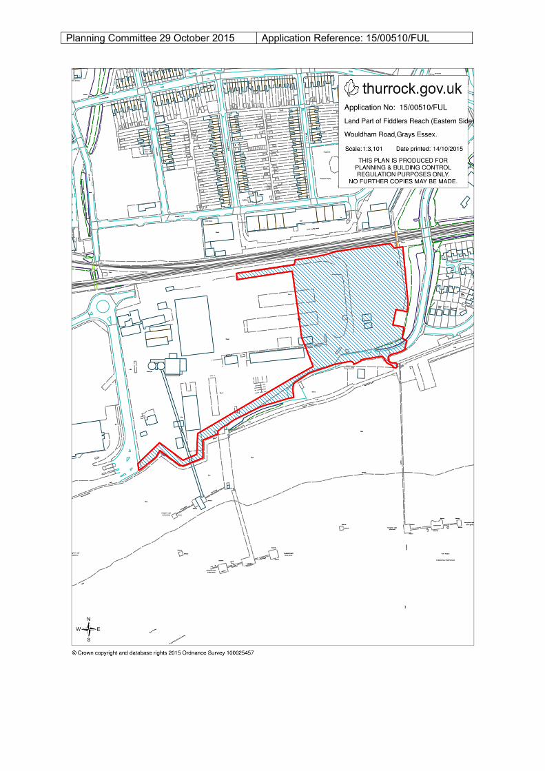
Planning Committee 29 October 2015 Application Reference: 15/00510/FUL