Reference: Site: Ward: Proposal 01508 TBC - Civic... · Planning Committee 10.01.2019 Application...
29
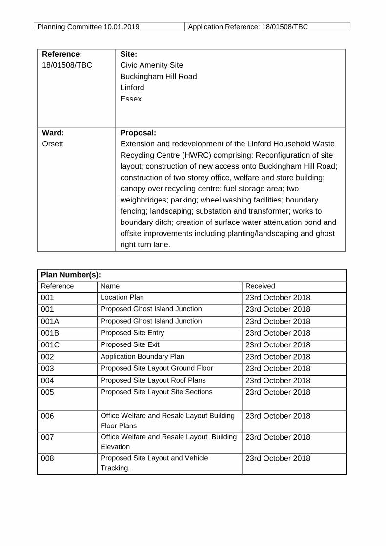
Planning Committee 10.01.2019 Application Reference: 18/01508/TBC Reference: 18/01508/TBC Site: Civic Amenity Site Buckingham Hill Road Linford Essex Ward: Orsett Proposal: Extension and redevelopment of the Linford Household Waste Recycling Centre (HWRC) comprising: Reconfiguration of site layout; construction of new access onto Buckingham Hill Road; construction of two storey office, welfare and store building; canopy over recycling centre; fuel storage area; two weighbridges; parking; wheel washing facilities; boundary fencing; landscaping; substation and transformer; works to boundary ditch; creation of surface water attenuation pond and offsite improvements including planting/landscaping and ghost right turn lane. Plan Number(s): Reference Name Received 001 Location Plan 23rd October 2018 001 Proposed Ghost Island Junction 23rd October 2018 001A Proposed Ghost Island Junction 23rd October 2018 001B Proposed Site Entry 23rd October 2018 001C Proposed Site Exit 23rd October 2018 002 Application Boundary Plan 23rd October 2018 003 Proposed Site Layout Ground Floor 23rd October 2018 004 Proposed Site Layout Roof Plans 23rd October 2018 005 Proposed Site Layout Site Sections 23rd October 2018 006 Office Welfare and Resale Layout Building Floor Plans 23rd October 2018 007 Office Welfare and Resale Layout Building Elevation 23rd October 2018 008 Proposed Site Layout and Vehicle Tracking. 23rd October 2018
-
Upload
nguyenkhanh -
Category
Documents
-
view
229 -
download
0
Transcript of Reference: Site: Ward: Proposal 01508 TBC - Civic... · Planning Committee 10.01.2019 Application...
Planning Committee 10.01.2019 Application Reference: 18/01508/TBC
Reference:
18/01508/TBC
Site:
Civic Amenity Site
Buckingham Hill Road
Linford
Essex
Ward:
Orsett
Proposal:
Extension and redevelopment of the Linford Household Waste
Recycling Centre (HWRC) comprising: Reconfiguration of site
layout; construction of new access onto Buckingham Hill Road;
construction of two storey office, welfare and store building;
canopy over recycling centre; fuel storage area; two
weighbridges; parking; wheel washing facilities; boundary
fencing; landscaping; substation and transformer; works to
boundary ditch; creation of surface water attenuation pond and
offsite improvements including planting/landscaping and ghost
right turn lane.
Plan Number(s):
Reference Name Received
001 Location Plan 23rd October 2018
001 Proposed Ghost Island Junction 23rd October 2018
001A Proposed Ghost Island Junction 23rd October 2018
001B Proposed Site Entry 23rd October 2018
001C Proposed Site Exit 23rd October 2018
002 Application Boundary Plan 23rd October 2018
003 Proposed Site Layout Ground Floor 23rd October 2018
004 Proposed Site Layout Roof Plans 23rd October 2018
005 Proposed Site Layout Site Sections 23rd October 2018
006 Office Welfare and Resale Layout Building
Floor Plans
23rd October 2018
007 Office Welfare and Resale Layout Building
Elevation
23rd October 2018
008 Proposed Site Layout and Vehicle
Tracking.
23rd October 2018

Planning Committee 10.01.2019 Application Reference: 18/01508/TBC
The application is also accompanied by:
- Design and Access Statement
- Landscape and Visual Appraisal
- Alternative Site Assessment
- Flood Risk Assessment
- Transport Assessment
- Construction Environmental Management Plan (CEMP)
- Land Quality Risk Assessment
Applicant:
Thurrock Council
Validated:
16 October 2018
Date of expiry:
15 January 2019
Recommendation: Grant planning permission, subject to: (i) referral to the Secretary
of State; and (ii) conditions.
This application is scheduled for determination by the Council’s Planning
Committee because the application has been submitted by the Council (in
accordance with Part 3 (b) Section 2 2.1 (b) of the Council’s constitution).
1.0 DESCRIPTION OF PROPOSAL
1.1 The application seeks planning permission for the extension and comprehensive redevelopment of the exiting Household Waste Recycling Centre (HWRC) on Buckingham Hill Road.
1.2 The application comprises the following components:
Extension of hardsurfaced area to the north of the existing site on land previously used for storage of waste containers and skips (see planning history 18/00878/CLEUD) to be used as a circulation and recycling area;
Formation of new site access at the northern end of the extended site
Proposed new internal vehicle access route within the site, to be one way in one way out for all vehicles;
Construction of a two storey building comprising store, offices, meeting room and welfare facilities;
Wheel washing facilities;
Weighbridge;
Reprofiling of existing southern part of site the to allow improved access to containers;
Provision of a ‘ghost island’ right tune lane into the new entrance;
Ancillary buildings comprising substation, cycle stand, smoking shelter; Refuelling station and refuelling bund.

Planning Committee 10.01.2019 Application Reference: 18/01508/TBC 1.3 In terms of background, the applicant indicates that there are a number of
operational difficulties which must be addressed:
The HWRC at Linford is in need of expansion and updating as it is failing to meet increasing demand effectively. Whilst the HWRC was designed to accept 6,000 tonnes of household waste per annum (tpa), it currently receives more than double that tonnage per annum. In addition, the amount of household waste coming into the Site is expected to increase in line with an increase in the number of households from 65,490 at present, to 78,100 by 2030.
and
As well as the lack of operational capacity, the HWRC has a number of constraints which prevent the efficient operation of the Site:
The existing Site access leads to conflict between cars and the HGVs entering
and leaving the Site to service the recycling containers. The inefficient Site layout leads to long queues out onto the highway and long waiting times for Site users.
Within the Site, there is a significant potential risk of conflict between cars and pedestrians as people park their vehicles and then walk across the Site to access the waste containers. Safety within the Site is also an issue as the access to many recycling containers involves the public carrying waste up steps to drop items down into the waste containers.
the HWRC does not have a connection to a mains sewer or mains electricity. The electricity generator and cess pit are costly to maintain and the HWRC is restricted to opening during daylight hours as lighting the Site using the generator is not feasible or cost effective.
There is no surface water drainage system within the Site boundary or within Buckingham Hill Road. All existing surface water drainage currently discharges into a highways ditch along the southern edge of the Site within the Site boundary and into the local watercourse system.
1.4 The above operational issues have led to the submission of the current application
before Members. 2.0 SITE DESCRIPTION
2.1 This application relates to the Council’s Civic Amenity Site, found on the western side of Buckingham Hill Road. The site is irregular in shape and found in the Metropolitan Green Belt.
2.2 The southern part of the site is hard surfaced and open to the public, comprising
skips and bins for the collection of household waste and recycling. 2.3 The northern part of the site is not open to the public and comprises an area used
for the storage of skips and waste containers in connection with the public use of the site to the south.

Planning Committee 10.01.2019 Application Reference: 18/01508/TBC
3.0 RELEVANT HISTORY
Application Reference
Description of Proposal Decision
99/00751/TBC The provision of a new access point to the civic amenity site.
Approved
18/00878/CLEUD
Certificate of lawfulness for storage of empty waste containers and skips
Deemed lawful
4.0 CONSULTATIONS AND REPRESENTATIONS
4.1 Detailed below is a summary of the consultation responses received. The full
version of each consultation response can be viewed on the Council’s website via
public access at the following link: www.thurrock.gov.uk/planning
PUBLICITY:
4.2 This application has been advertised by way of individual neighbour notification
letters, press advert and public site notices which have been displayed nearby. No
responses have been received.
4.3 ENVIRONMENT AGENCY:
No objections, subject to conditions.
4.4 ENVIRONMENTAL HEALTH:
No objections, subject to conditions.
4.5 FLOOD RISK MANAGER:
No objection subject to conditions.
4.6 HIGHWAYS:
No objections, subject to condition.
4.7 HSE
Do no advise against.

Planning Committee 10.01.2019 Application Reference: 18/01508/TBC 5.0 POLICY CONTEXT
National Planning Policy Framework
5.1 The NPPF was published on 27 March 2012 and amended on 24 July 2018. Paragraph 10 of the Framework sets out a presumption in favour of sustainable development. Paragraph 2 of the Framework confirms the tests in s.38 (6) of the Planning and Compulsory Purchase Act 2004 and s.70 of the Town and Country Planning Act 1990 and that the Framework is a material consideration in planning decisions. Paragraph 11 states that in assessing and determining development proposals, local planning authorities should apply the presumption in favour of sustainable development. The following headings and content of the NPPF are relevant to the consideration of the current proposals: 2. Achieving sustainable development 14. Meeting the challenge of climate change, flooding and coastal change 16. Conserving and enhancing the historic environment
Planning Practice Guidance
5.2 In March 2014 the Department for Communities and Local Government (DCLG)
launched its planning practice guidance web-based resource. This was
accompanied by a Written Ministerial Statement which includes a list of the
previous planning policy guidance documents cancelled when the NPPF was
launched. The PPG contains 42 subject areas, with each area containing several
subtopics. Those of particular relevance to the determination of this planning
application comprise:
Design;
Determining a planning application;
Flood risk and coastal change;
Land affected by contamination;
Natural environment;
Noise;
Travel Plans, Transport Assessments and Statements; and
Use of planning conditions
Local Planning Policy
Thurrock Local Development Framework
5.3 The Council adopted the “Core Strategy and Policies for the Management of
Development Plan Document” (as amended) in 2015. The following Core Strategy
policies apply to the proposals:
Planning Committee 10.01.2019 Application Reference: 18/01508/TBC
Spatial Policies:
CSSP4 (Sustainable Greenbelt) and
OSDP1 (Promotion of Sustainable Growth and Regeneration in Thurrock)
Thematic Policies:
CSTP22 (Thurrock Design)
CSTP27 (Management and Reduction of Flood Risk)
CSTP29 (Waste Management)
Policies for the Management of Development:
PMD1 (Minimising Pollution and Impacts on Amenity)
PMD2 (Design and Layout)
PMD8 (Parking Standards)
PMD9 (Road Network Hierarchy)
PMD10 (Transport Assessments and Travel Plans) and
PMD15 (Flood Risk Assessment)
[Footnote: 1New Policy inserted by the Focused Review of the LDF Core Strategy.
2Wording of LDF-
CS Policy and forward amended either in part or in full by the Focused Review of the LDF Core
Strategy. 3Wording of forward to LDF-CS Policy amended either in part or in full by the Focused
Review of the LDF Core Strategy].
Thurrock Local Plan
In February 2014 the Council embarked on the preparation of a new Local Plan for
the Borough. Between February and April 2016 the Council consulted formally on
an Issues and Options (Stage 1) document and simultaneously undertook a ‘Call
for Sites’ exercise. In December 2018 the Council began consultation on an Issues
and Options (Stage 2 Spatial Options and Sites) document.
6.0 ASSESSMENT
Process
With reference to procedure, this application has been advertised as a departure
from the Development Plan. Any resolution to grant planning permission would
need to be referred to the Secretary of State under the terms of the Town and
Country Planning (Consultation) (England) Direction 2009 with reference to the
‘other development which, by reason of its scale or nature or location, would have a
significant impact on the openness of the Green Belt’. The Direction allows the

Planning Committee 10.01.2019 Application Reference: 18/01508/TBC
Secretary of State a period of 21 days (unless extended by direction) within which
to ‘call-in’ the application for determination via a public inquiry. In reaching a
decision as to whether to call-in an application, the Secretary of State will be guided
by the published policy for calling-in planning applications and relevant planning
policies. The Secretary of State will, in general, only consider the use of his call-in
powers if planning issues of more than local importance are involved.
The planning issues to be considered in this case are:
I. Development Plan designation & principle of development
II. Site layout and design
III. Impact on amenity
IV. Highways & transportation
V. Flood risk
VI. Ground conditions
I. DEVELOPMENT PLAN DESIGNATION & PRINCIPLE OF DEVELOPMENT
6.1 Under this heading, it is necessary to refer to the following key questions:
1. Whether the proposals constitute inappropriate development in the Green Belt; 2. The effect of the proposals on the open nature of the Green Belt and the
purposes of including land within it; and 3. Whether the harm to the Green Belt is clearly outweighed by other
considerations so as to amount to the very special circumstances necessary to justify inappropriate development.
1. Whether the proposals constitute inappropriate development in the Green Belt
6.2 The site is identified on the Core Strategy Proposals Map as being within the Green Belt where policies CSSP4 and PMD6 apply. Policy CSSP4 identifies that the Council will ‘maintain the purpose function and open character of the Green Belt in Thurrock’, and Policy PMD6 states that the Council will ‘maintain, protect and enhance the open character of the Green Belt in Thurrock’. These policies aim to prevent urban sprawl and maintain the essential characteristics of the openness and permanence of the Green Belt to accord with the requirements of the NPPF.
6.3 Paragraph 79 within Chapter 9 of the NPPF states that the Government attaches great importance to Green Belts and that the “fundamental aim of Green Belt policy is to prevent urban sprawl by keeping land permanently open; the essential characteristics of Green Belt are their openness and their permanence.” Paragraph 89 states that a local planning authority should regard the construction of new buildings as inappropriate in Green Belt. The NPPF sets out a limited number of exceptions to this, namely:
buildings for agriculture and forestry;
appropriate facilities for outdoor sport, recreation and cemeteries;
Planning Committee 10.01.2019 Application Reference: 18/01508/TBC
proportionate extensions or alterations to a building;
the replacement of a building;
limited infilling in villages; and the partial or complete redevelopment of previously developed sites whether
redundant or in continuing use (excluding temporary buildings), which would not have a greater impact on the openness of the Green Belt and the purpose of including land within it than the existing development.
6.4 The site, due to is planning history, is considered to fall within the NPPF definition of Previously Developed Land (PDL). However, the proposed development would result in an increased built form which would also be spread across a wider area than the current use of the site.
6.5 Accordingly the proposal would have a greater impact on the openness of the
Green Belt and the purpose of including land within it than the existing development. Consequently, the proposals comprise inappropriate development with reference to the NPPF and policy PMD6.
2. The effect of the proposals on the open nature of the Green Belt and the purposes of including land within it
6.6 Having established that the proposals are inappropriate development, it is
necessary to consider the matter of harm. Inappropriate development is, by definition, harmful to the Green Belt, but it is also necessary to consider whether there is any other harm to the Green Belt and the purposes of including land therein.
6.7 Paragraph 134 of the NPPF sets out the five purposes which the Green Belt serves as follows:
A. to check the unrestricted sprawl of large built-up areas; B. to prevent neighbouring towns from merging into one another; C. to assist in safeguarding the countryside from encroachment; D. to preserve the setting and special character of historic towns; and E. to assist in urban regeneration, by encouraging the recycling of derelict and
other urban land.
6.8 In response to each of these five purposes: A. to check the unrestricted sprawl of large built-up areas
6.9 The NPPF does not provide a definition of the term ‘large built-up areas’ but given
the sites location it is located away from the large built-up areas of Grays, Tilbury, Stanford Le Hope and Corringham the site is located distant from any defined settlements. The proposal would not therefore result in sprawl.
B. to prevent neighbouring towns from merging into one another
6.10 The proposal would not result in towns merging into one another.
Planning Committee 10.01.2019 Application Reference: 18/01508/TBC C. to assist in safeguarding the countryside from encroachment 6.11 The proposal would involve increased built development on this site which is
surrounded by the countryside to the north, east and south. It is considered that the proposal would constitute an encroachment of increased built development into the countryside at this location, causing some harm to the third purpose for including land in the Green Belt.
D. to preserve the setting and special character of historic towns 6.12 As there are no historic town in the immediate vicinity of the site, the proposals do
not conflict with this defined purpose of the Green Belt.
E. to assist in urban regeneration, by encouraging the recycling of derelict and other urban land
6.13 In general terms, the development could occur in the urban area and, in principle
there is no spatial imperative why Green Belt land is required to accommodate the proposals, however it is recognised that the site has performed the function of a Civic Amenity Site for many years. To a limited extent, the proposed development is inconsistent with this purpose of the Green Belt.
6.14 In light of the above analysis, it is considered that the proposals would be contrary
to 2 of the 5 purposes of including land in the Green Belt. Substantial weight should be afforded to these factors. 3. Whether the harm to the Green Belt is clearly outweighed by other
considerations so as to amount to the very special circumstances necessary to justify inappropriate development
6.15 Neither the NPPF nor the Adopted Core Strategy provide guidance as to what can
comprise ‘very special circumstances’, either singly or in combination. However, some interpretation of very special circumstances has been provided by the Courts. The rarity or uniqueness of a factor may make it very special, but it has also been held that the aggregation of commonplace factors could combine to create very special circumstances (i.e. ‘very special’ is not necessarily to be interpreted as the converse of ‘commonplace’). However, the demonstration of very special circumstances is a ‘high’ test and the circumstances which are relied upon must be genuinely ‘very special’. In considering whether ‘very special circumstances’ exist, factors put forward by an applicant which are generic or capable of being easily replicated on other sites, could be used on different sites leading to a decrease in the openness of the Green Belt. The provisions of very special circumstances which are specific and not easily replicable may help to reduce the risk of such a precedent being created. Mitigation measures designed to reduce the impact of a proposal are generally not capable of being ‘very special circumstances’. Ultimately, whether any particular combination of factors amounts to very special circumstances will be a matter of planning judgment for the decision-taker.
6.16 With regard to the NPPF, paragraph 143 states that ‘inappropriate development is, by definition, harmful to the Green Belt and should not be approved except in very

Planning Committee 10.01.2019 Application Reference: 18/01508/TBC
special circumstances’. Paragraph 144 goes on to state that, when considering any planning application, local planning authorities “should ensure that substantial weight is given to any harm to the Green Belt. Very special circumstances will not exist unless the potential harm to the Green Belt by reason of inappropriateness, and any other harm, is clearly outweighed by other considerations”.
6.17 The submitted Planning Statement sets out the applicant’s reasons for the proposal coming forward.
a. The area to the north of the main site has been used for 10 years or more
6.18 The area to the north of the public area of the site is used for the storage of
containers and skips which are subsequently used on the site. These skips are stored there before being used on the site. A lawful development certificate has been deemed lawful for the use of the site for these purposes.
Consideration 6.19 It is accepted that the land to the northern part of the site could be used for the
storage of containers and skips in association with the use of the southern area of the site.
6.20 Significant weight can be attached to this linked lawful use (though it is noted that
the northern part of the site would be more intensively used under the current permission if approved).
b. Alternative Site Assessment demonstrates there are no alterative locations
6.21 The applicant advises that Council previously operated a second Civic Amenity Site
at West Thurrock. The site was subject to very low volumes of waste due to a combination of material acceptance policy and site location. The site was deemed not to be viable and was closed within a year of being opened leaving the Linford site as the only Civic Amenity site in the Borough. The applicant has carried out a detailed alterative site assessment which looked at other possible sites for a new HWRC using the following criteria:
- There should be suitable HGV access to enable vehicles moving the containers
to enter and exit the site safely; - The site should be separate from residential properties due to the noise, smells,
traffic and other nuisance that can be associated with such facilities; - The site should not be too isolated or difficult to reach so as not to prevent or
discourage some residents from using the facility; - The site should be at least equivalent in size to the existing Buckingham Hill site
(0.7ha) but ideally at least 1ha; - It should be able to accommodate a split-level operation which minimises the
need to users to have to climb steps to empty contents into containers, to improve safety and accessibility;
- The site should comprise predominately non-permeable hardstanding with adequate interceptors to prevent leachate run-off;
- The site should be connected to the mains sewer and have access to other

Planning Committee 10.01.2019 Application Reference: 18/01508/TBC
utilities e.g. electricity and broadband; - The site should have good access to A13 to avoid HGVs having to pass through
residential areas. Also as there is only one site in the borough it should as central as possible and easy to reach by car;
- Ideally the site should be in council ownership as there is not sufficient resources currently available to enable the purchase of a new site.
6.22 The site assessment indicates that HWRCs are not suitable for residential areas
due to noise, smells and traffic, and in areas allocated for residential development the loss of land for housing would be unlikely to be supported. The assessment further considers that HWRCs are not ideal for industrial areas due to the HGV levels associated with those uses. Areas such as London Gateway and Thames Enterprise Park are deemed to be too remote for most Borough residents. A potential site in Botany Way Purfleet has been considered but was discounted due to it being inaccessible for residents from the east of the Borough.
6.23 Four sites met the criteria for detailed consideration and are discussed below as follows:
o Former Council Nursery, Bull Meadow, Little Thurrock:
Formally a plant nursery, 1.8 ha in size and partly surfaced with services in or close to the side, good links to A13.
Site in the Green Belt. Immediately adjacent to residential properties to the south and west,
resulting in creating noise, smells and traffic congestion to residents. Access off Dock Road/Marshfoot road is on a sharp bend which would not
provide suitable and safe highways access.
DISCOUNTED for highways and amenity issues.
o Land off Fort Road Tilbury: Presently used for grazing, 8ha in size Outside the Green Belt. Northern part of the site will be used for link to Tilbury 2 development, part
of the land is in a coastal grazing marsh, part of Tilbury Marshes Local Wildfire Site and approximately 120m north of Tilbury Fort SAM.
DISCOUNTED for impact on ecology, proximity to SAM and the site would
not be readily accessible to most residents in the Borough.
o Thurrock Park Way (TPW) To the west and north of TPW and Clipper Park, 3.5 ha in size, identified as
employment land. Outside the Green Belt. Access through adjacent commercial areas, much of the site would be
away from residential properties, though some would be close to properties on Churchill Road. Site is low level marsh land so could lead to leaching and a flood risk assessment would be needed.
DISCOUNTED due to high number of existing HGV movements, potential

Planning Committee 10.01.2019 Application Reference: 18/01508/TBC
for more appropriate commercial use and application to west for residential development (15/00234/FUL – Manor Road) if approved would result in a number of residential properties nearby.
o Land adjacent to Stanford Road, Grays
Currently used for horse grazing, measuring 2.6ha in size. Site is in the Green Belt. Close to existing development so services would be available, located on a
straight road with good visibility. DISCOUNTED due to site being open and flat and difficult to screen,
proximity to residential areas to the south and west, and Treetops school to the south east, making it a bad neighbour use.
o Sites at Wharf Road, Billet Lane and Baker Street were also considered but
did not make the list of detailed assessment due to factors which made them immediately unsuitable for shortlisting.
Consideration 6.24 The criteria for determining what is required for a new/extended HWRC are
considered to be appropriate. The four sites that were taken forward for detailed assessment are considered to individually have some elements that would make them suitable for the proposed use, however taken as a whole it is considered that there are factors which make the discounting of each site justified.
6.25 Accordingly, it is considered at this time, that the proposed site is the only one
which could adequately accommodate the proposed extended site. Significant weight should be given the lack of suitable alternative sites.
c. The provision of a dedicated right turn lane (ghost lane)
6.26 The application it is advised, due to the increasing length of the site, would allow
space for the provision of a ghost tight turn lane into the site. The distance of 50m from the site entrance to the entrance to the lane would allow approximately 10 cars waiting to access to site to sit safely away from vehicles proceeding south along Buckingham Hill Road, preventing queues building up, as happens at present.
Consideration 6.27 At present the northern entrance to the site is an in-out access point for HGVs and
an exit for cars. This causes safety issues and conflict on the highway between vehicles accessing the site and causes vehicles to wait on Buckingham Hill Road causing highways safety issues. The new single entrance for HGVs and cars at the north served by the ghost lane would reduce conflict and allow vehicles to wait safely without causing queueing on Buckingham Hill Road.
6.28 The provision of the right turn lane would not occur without the development taking
place and it would provide wider benefits to other road users. As such this factor

Planning Committee 10.01.2019 Application Reference: 18/01508/TBC
should be afforded moderate weight in the determination of the application.
d. Operational Issues Waste & Resources Action Programme (WRAP) / Staff welfare
6.29 The applicant has advised that the use of the site has grown over time, and it is
now operating over capacity and the layout results in a number of Health and Safety issues, which cannot be solved within the compact single level site. The applicant advises the following:
The current site layout and service provisions associated with the Linford HWRC do not meet the best practice guidance recommendations set down in the Household Waste Recycling Centre (HWRC) Guide published by WRAP - which was formed to assist Local Authorities concerning Waste and Recycling best practice and guidance. The guide incorporates a section on Health and Safety issues which could have an impact on customers, operatives and contractors. Amongst other things, the guide makes reference for the need to adopt traffic control measures and a safe layout in order to comply with the Health and Safety Workplace regulations. It also points out that in Northern Ireland in 2011 a worker was trapped and killed at a HWRC. This, quite rightly, should make the Council recognise the need for the best safe working practices at the HWRC. The Health and Safety Executive has also published guidance on how to avoid risks at HWRCs. It echoes the WRAP guidance and makes reference to safe layout and control measures. It uses a case study of site design by Cumbria County Council incorporates a split level design site. The site has similar features to that proposed for Linford. One key feature of modern HWRCs is that the site layout is designed to minimise the interaction between customers and traffic, this can be best achieved by using a “split-level” design where servicing the containers is in an area which is completely segregated from customers. In addition, to avoid slips trips and falls, the use of stairways can be minimised by using a split - level site where storage containers are located at a lower level to customers. A split level site therefore affords the opportunity to segregate service vehicles and avoid stairways at a stroke. In addition, the proposed redeveloped layout at Linford would further improve safety by avoiding the need for pedestrians to cross traffic lanes to deposit materials. Split level designs necessitate a ramp within the site to bring customers to a higher level (or service vehicles to a lower level). To accommodate a safer split level site and provide vehicle stacking means that a slightly larger footprint to accommodate these features would be required at the Linford site. It must be emphasised that these safety features cannot physically be provided at the site within the current authorised footprint.
6.30 The applicant also advises that with no permanent electricity supply the site cannot
be operated appropriately. They state that The site “currently relies on a diesel powered generator. This requires fuel storage (with inherent risks of theft, fire and pollution)….that [t]he generator is both noisy, requires servicing and produces air emissions and does not provide sufficient power to enable the site to have a combination of adequate lighting or CCTV. Such generators do interrupt operations with downtime…[which]would be unacceptable with a modern weigh-bridge. The current generator does not provide site lighting / security lighting and heat for modern site welfare offices or a weigh bridge office. A larger generator would be noisier and very expensive to hire and run and be easily accommodated within the cramped conditions at the site”.
Consideration

Planning Committee 10.01.2019 Application Reference: 18/01508/TBC 6.31 The supporting information indicates that the site is presently severely deficient in
terms of both the working conditions for employees of the site and the health and safety of users of the site. The Council has a duty of care to its staff and customers, which are clearly not being served by the premises as it exists. The Council would not want to invest resources in development that was not absolutely necessary and it is considered therefore that the extension of the site area and associated to address the shortcomings of the site are reasonable. . Accordingly, significant weight can be attributed to these matters at this time.
e. Trade Waste / Greater Recycling / Third party reuse
6.32 The applicant advises that the site is operating over capacity, by approximately 8,000 tonnes per year, in part due to the large amount of illegal trade waste the site receives. The applicant advises the provision of the weighbridge would allow waste coming on the site to be monitored and this would allow an additional revenue stream. This combined with more clearly defined areas and easy to use site it is considered would also improve recycling through the site. It is also proposed that items brought to the site that could be effectively reused through third party charities could be collected on site and stored before being distributed.
Consideration
6.33 The improved recycling levels would be beneficial to the Council’s aspirations to improve recycling and would reduce the impact of landfill material. Policy CSPT29 seeks, amongst other things “the increased re-use/recycling and recovery of waste” as a central theme. The ability to improve recycling should be therefore given moderate weight. The provision of a dedicated area for commercial waste should reduce fly-tipping and could create revenue for the Council to reinvest in waste management activities. The option to allow third parties to reuse items rather than them being placed in landfill or broken down for recycling would have wider sustainability benefits.
6.34 Collectively these matters should be attributed moderate weight.
f. Potential for surface water run-off and drainage into watercourse and onto highway to be reduced
6.35 The applicant refers to the fact that the site presently does not have mains drainage, that there is no surface water drainage system within the site boundary and so accordingly surface water discharges into a highways ditch alongside the southern edge of the site, into the local watercourses and onto the public highway. The current drainage arrangements at incorporate a dilute and disperse system for surface water. It is likely that some areas of the site will lead to contamination of surface water. The proposed scheme would result in a full drainage system being installed within the site and would provide a water attenuation pond to the southern end of the site to deal with surface water.
Consideration

Planning Committee 10.01.2019 Application Reference: 18/01508/TBC
6.36 The site presently accepts a variety of waste materials. Where these materials are stored outside they will be subject to the effect of rain.. A HWRC by its very nature will be dirty and surface water from the site draining into local watercourses will not be beneficial to the local environment. The proposal to introduce a sustainable drainage scheme will prevent pollution of the local watercourses.
6.37 In addition officers have received numerous complaints in recent years about mud and water on the highway on Buckingham Hill Road in the vicinity of this site. The unmade nature of the highways boundary in this part of the road will always result in some form of mud on the highway, however preventing surface water run-off from the site will clearly reduce this impact and improve highways safety. Accordingly these matters should be afforded moderate weight in the determination of the very special circumstances case.
g. Policy CSTP29: Waste Strategy
6.38 The applicant advises on the following wording of Policy CSTP29: New development for waste management will not be permitted in the Green Belt, unless part of a necessary restoration scheme and the proposals conform with Green Belt policy. The exception to this is the provision of small scale facilities which address an identified local need where no suitable sites outside the Green Belt have been shown to exist following an alternative assessment. They consider this supports their case.
Consideration
6.39 Policy CSTP29 states under sub-section 3 that the preferred approach is for 1or 2 strategic sites within broad locations and located within appropriate employment and industrial /port locations. The locations of these sites were supposed to come through the minerals and waste DPD. The strategic sites were intended to provide capacity to meet most of the equivalent of the Borough’s waste arisings for Household and C&I waste.
6.40 The policy continues that where strategic sites allocations are proven to be undeliverable or waste management capacity requirements cannot be met on allocated sites planning permission in non-strategic areas would be considered in
i. Existing waste management facilities; except landfill sites;
ii. Appropriate employment locations;
iii. Appropriate port locations and
iv. Where such proposal met the other relevant policies in the Core Strategy and the waste and minerals plan.
6.41 The last paragraph in subsection 3 states that “new development for waste management will not be permitted in the Green Belt, unless part of a necessary restoration scheme. The exception to this is the “provision of small scale facilities

Planning Committee 10.01.2019 Application Reference: 18/01508/TBC
to meet local need where no suitable sites outside the Green Belt have been identified”. (emphasis added). The policy is therefore clear that large scale proposals that go beyond local need in the Green Belt would be contrary to this policy.
6.42 Accordingly at this time, little weight can be attached to this matter.
Summary of Very Special Circumstances
6.43 The table below provides a summary of the Very Special Circumstances and the
weight that is attributed to them in assessing the planning balance for the whether the principle of the development is acceptable
Summary of Green Belt Harm and Very Special Circumstances
Harm Weight Factors Promoted as Very
Special Circumstances
Weight
Inappropriate
Development
Substantial The area to the north of the main site has been used for 10 years or more
Significant
weight
Reduction in the openness of the Green Belt
Alternative Site Assessment demonstrates there are no alterative locations
Significant
weight
The provision of a dedicated right turn lane (ghost lane)
Moderate weight
Operational Issues Waste & Resources Action Programme (WRAP) / Staff welfare
Significant weight
Trade Waste / Greater Recycling / Third party reuse
Moderate weight
Potential for surface water run-off and drainage into watercourse and onto highway to be reduced
Moderate weight
Wording of Policy CSTP29: Waste Strategy
Signficant weight

Planning Committee 10.01.2019 Application Reference: 18/01508/TBC
6.44 As ever, in reaching a conclusion on Green Belt issues, a judgement as to the
balance between harm and whether the harm is clearly outweighed must be reached. In this case there is harm to the Green Belt with reference to inappropriate development and loss of openness. However, this is not considered to be the full extent of the harm. Several factors have been considered by the applicant to be ‘very special circumstances’ and it is for the Committee to judge:
i. the weight to be attributed to these factors; ii. whether the factors are genuinely ‘very special’ (i.e. site specific) or whether the
accumulation of generic factors combine at this location to comprise ‘very special circumstances’.
6.45 Taking into account all Green Belt considerations, it is considered that the identified
harm to the Green Belt is clearly outweighed by the accumulation of factors described above, so as to amount to the very special circumstances justifying inappropriate development.
II. SITE LAYOUT & DESIGN
6.46 The site is irregular in shape and is constrained by Buckingham Hill Road to the
east and the levels of the land to the west. The sectional drawing submitted with the
application show that the land on the immediate western site boundary is
approximately 2.5m higher than the land on the east, which is at the same level as
Buckingham Hill Road. The effect of this would be to screen to some degree the
built form on the site from the west.
6.47 The public areas would be located primarily to the western side of the site, and the
servicing / staff and commercial areas to the centre and eastern side of the site.
This would provide separation between the different users to prevent conflict and
improve safety. This is considered to be a suitable layout in operational and design
terms.
6.48 The design of the site has been planned to take into account the slope and effect of
the level of the land to the western side. The two storey office / welfare building
would be sited towards the middle of the site, away from the back of the highway.
The roof of this building has been designed to pitch away from the highway to try
and reduce its visual impact from the main public vantage points. The location of
this building is considered to be appropriate in terms of, and to ensure, the
functionality of the site.
6.49 The proposed higher level ramped areas would be located around the western
periphery of the site; this arrangement is proposed due to operational issues, but

Planning Committee 10.01.2019 Application Reference: 18/01508/TBC
this would allow some screening of the higher area by the land outside the site.
This is considered to be the most appropriate area for the higher land levels.
6.50 Smaller ancillary buildings such as the cycle store, smoking shelter, and substation
would be located close to the office building and the oil and fuels store would be
located within the HGV area to the southern part of the site. These locations are
considered to be appropriate.
6.51 By its very nature the overall appearance of the site will be functional, with large
concrete surfacing to ensure the site is easy to manage and to channel run off.
6.52 The design and appearance of the proposed office and welfare building is a product
of the function that it would perform; the building would be similar to other
commercial buildings in the Borough, with a brick finish to the ground floor and a
metal cladding to the first floor. A covered canopy to a small part of the recycling
area will also be provided. Given the context of the HWRC, this is considered to be
acceptable and subject to the use of appropriately coloured external finishes no
objection is raised to this element of the proposal.
6.53 Landscaping is proposed along the eastern boundary of the site where it adjoins
Buckingham Hill Road. Suitable landscaping would help soften the impact of the
development on the area and should form part of a condition on any consent
granted.
III. IMPACT ON AMENITY
6.54 The closest ‘sensitive’ receptor to the site is the residential property, Mayfield some
200m to the north east of the site. This property is considered to be suitably distant
from the site for there to be no significant impact on their outlook or amenity.
6.55 The application has been accompanied by a lighting scheme, a Construction
Environment Management Plan (CEMP) for the period of construction and details of
opening hours. The Council’s Environment Health team have raised no objections
and accordingly it is considered that the proposal would be acceptable in relation to
neighbour amenity issues.
IV. HIGHWAYS AND TRANSPORTATION
6.56 The application proposes changes within the site and on the public highway. The
present northern access is to be closed up and a new access will be formed in the
‘extension’ area of land, to the north.

Planning Committee 10.01.2019 Application Reference: 18/01508/TBC 6.57 A ‘Ghost Island’ right turn lane will be formed on the public highway to prevent
vehicles travelling south along Buckingham Hill Road being held up by any vehicles
queuing to access the site.
6.58 In addition, the changes to the access and the internal circulation areas within the
site will allow a one entrance in, one exit out for all vehicles. At present HGVs enter
and exit from the northern access causing conflict with cars exiting the site.
6.59 The changes to the access and internal arrangements will have a positive impact
on highways safety, allowing vehicles to enter and exit the site more easily and will
minimise the impact of vehicles queuing on the highway. These are all considered
to be positive points in support of the proposals.
6.60 The application is supported by a Transport Assessment (TA). The TA confirmed
that when all trips to the site were considered (including operation trips, customer
trips and staff trips) there are an average of 784 two-way movements on an
average weekday and 1,166 on an average weekend.
6.61 The TA indicates that the proposed improvements to the site will have no
noticeable impact on the highways network and that it will not negatively impact on
the capacity of Buckingham Hill Road and its junction with the A1013.
6.62 The Highways Officer has reviewed the application and has raised no objection to
the proposals and recommends a single condition relating to sight splay provision
at the access points onto Buckingham Hill Road. Accordingly, the proposals are
considered to comply with the relevant criteria of Policies PMD8, PMD9 and
PMD10 of the Core Strategy.
V. FLOOD RISK
6.63 The application site lies within Flood Zone 1 (Low Risk) and no historic evidence of
flooding at the site has been found.
6.64 A Flood Risk Assessment (FRA) has been submitted with the application given the
changes proposed on the site, in particular in relation to drainage; this FRA found
that the only flooding from land from surface water was considered to be a risk and
this was in a localised part of the site, close to the existing site entrance.
6.65 The Environment Agency (EA) surface water flood map indicates that during an
event with a 1% AEP (or 1 in 100 year annual exceedance probability) of re-
occurrence, flood depths in the area immediately adjacent to the entrance to the
site would be less than 0.3m. The application has incorporated basic flood
resilience measures into the redesign of the HWRC, including elevating electrics at

Planning Committee 10.01.2019 Application Reference: 18/01508/TBC
least 0.5m above the finished floor level (in line with Building Regulations) and
avoiding the use of porous surfacing at ground floor level despite the limited risks.
6.66 Neither the EA nor the Council’s Flood Risk Manager has raised any objections,
subject to conditions. Accordingly subject to suitable planning conditions, the
proposals comply with the relevant criteria of Policies CSTP27 PMD2 and PMD15.
VI. GROUND CONDITIONS
6.67 The land to the immediate west of the application site is a former landfill site
(THU0036). The Council’s Environmental Health Officer advises that landfill gas
from the site has been proved to be affecting the land to the western boundary.
Accordingly, he has recommended that a landfill gas monitoring programme be
carried out to ensure there are no gas issues arising and to determine whether any
protection measures are required. This could be covered by a condition.
6.68 The EA concur with the details submitted in the contaminated land assessment and
recommended similar conditions be applied. Subject conditions, no objections are
raised on the basis of ground conditions and contamination.
7.0 CONCLUSIONS AND REASON(S) FOR APPROVAL
7.1 The application site is in the Green Belt and as submitted, the proposal represents
inappropriate development. The applicant has put forward a strong case for Very
Special Circumstances to justify the development, the most significant being the
clear lack of alternative sites, either inside or outside the Green Belt and the
lawfulness of the use land to the immediate north of the public area of the site
These and the other matters put forward are considered to clearly outweigh the
harm the Green Belt, the test that is required by the NPPF to allow inappropriate
development.
7.2 In relation to design, appearance, layout and scale the proposal would be
acceptable and in terms of technical highways matters the level of activity would be
acceptable. Other matters of detail are also considered to be appropriate, subject to
conditions.
7.3 Accordingly, the proposals are considered to comply with Policies OSDP1, CSSP3,
CSSP4, CSTP22, CSTP23 and Policies PMD1, PMD2, PMD6, PMD8, PMD9,
PMD10 and PMD15 of the Core Strategy.
8.0 RECOMMENDATION
Grant planning permission subject to:

Planning Committee 10.01.2019 Application Reference: 18/01508/TBC
A: Referral to the Secretary of State (Planning Casework Unit) under the terms of
the Town and Country Planning (Consultation) (England) Direction 2009, and
subject to the application not being ‘called-in’ for determination
And
B: Conditions
Time Limit:
1. The development hereby permitted shall be begun before the expiration of three
years from the date of this permission.
Reason: To comply with Section 91(1) of The Town & Country Planning Act 1990
as amended by Section 51 of the Planning and Compulsory Purchase Act 2004.
Accordance with plans:
2. The development hereby permitted shall be carried out in accordance with the
following approved plans:
Plan Number(s):
Reference Name Received
001 Location Plan 23rd October 2018
001 Proposed Ghost Island Junction 23rd October 2018
001A Proposed Ghost Island Junction 23rd October 2018
001B Proposed Site Entry 23rd October 2018
001C Proposed Site Exit 23rd October 2018
002 Application Boundary Plan 23rd October 2018
003 Proposed Site Layout Ground Floor 23rd October 2018
004 Proposed Site Layout Roof Plans 23rd October 2018
005 Proposed Site Layout Site Sections 23rd October 2018
006 Office Welfare and Resale Layout Building
Floor Plans
23rd October 2018
007 Office Welfare and Resale
Layout Building Elevation
23rd October 2018
008 Proposed Site Layout and Vehicle
Tracking.
23rd October 2018
Reason: For the avoidance of doubt and to ensure that the development is carried
Planning Committee 10.01.2019 Application Reference: 18/01508/TBC
out in accordance with the details as approved with regard to policies PMD1 and
PMD2 of the adopted Thurrock LDF Core Strategy and Policies for the
Management of Development (as amended 2015).
Details of materials:
3. Notwithstanding the information on the approved plans, no development shall
commence above finished ground levels until written details or samples of all
materials to be used in the construction of the external surfaces of the development
hereby permitted have been submitted to and approved in writing by the local
planning authority. The development shall be carried out using the materials and
details as approved.
Reason: In the interests of visual amenity and to ensure that the proposed
development is integrated with its surroundings in accordance with policy PMD2 of
the adopted Thurrock LDF Core Strategy and Policies for the Management of
Development (as amended 2015).
Boundary treatments:
4. Prior to the first use or operation of the development, details of the design,
materials and colour of the fences and other boundary treatments shown on
drawing no. 003 Proposed Site Layout Ground Floor shall be submitted to and
approved in writing by the local planning authority. The fences and other boundary
treatments as approved shall be completed prior to the first use or operation of the
development and shall be retained and maintained as such thereafter.
Reason: In order to safeguard the amenities of neighbouring occupiers and in the
interests of the visual amenity of the area in accordance with policies PMD1 and
PMD2 of the adopted Thurrock LDF Core Strategy and Policies for the
Management of Development (as amended 2015).
External lighting:
5. The external lighting on the site shall be installed in accordance with the details
included in Appendix E of submitted Planning Statement, prior to first use or
operation of the development and retained and maintained thereafter in the agreed
form, unless otherwise agreed in writing by the local planning authority.
Reason: In the interests of highway safety and residential amenity and to ensure
that the development can be integrated within its immediate surroundings in
accordance with Policies PMD1 and PMD2 of the adopted Thurrock LDF Core
Strategy and Policies for the Management of Development (as amended 2015).

Planning Committee 10.01.2019 Application Reference: 18/01508/TBC
Soft landscaping:
6. Within the first available planting season (October to March inclusive) following the
commencement of the development the soft landscaping works as shown on shown
on drawing no LC-06 Landscape Strategy of Appendix D Landscape and Visual
Appraisal shall be implemented. If within a period of five years from the date of the
planting of any tree or plant, or any tree or plant planted in replacement for it, is
removed, uprooted or destroyed or dies, or becomes, in the opinion of the local
planning authority, seriously damaged or defective, another tree or plant of the
same species and size as that originally planted shall be planted at the same place,
unless the local planning authority gives its written consent to any variation.
Reason: To secure appropriate landscaping of the site in the interests of ecology,
visual amenity and the character of the area in accordance with policies CSTP18,
PMD2 and PMD7 of the adopted Thurrock LDF Core Strategy and Policies for the
Management of Development (as amended 2015).
Surface Water Drainage:
7 Prior to the commencement of the development details of the surface water
drainage scheme to serve the development shall be submitted to and agreed in
writing by the local planning authority. The agreed scheme shall be implemented
prior to the first occupation of the development. The scheme shall ensure that for a
minimum:
• Run-off from the site is limited to greenfield rates for a storm event that has a
100% chance of occurring each year (1 in 1 year event).
• The development should be able to manage water on site for 1 in 100 year events
plus 40% climate change allowance. finished first floor levels set no lower than 6.20
metres above Ordnance Datum (AOD).
Reason: To ensure that adequate drainage measures to prevent surface water
runoff and for the safety of the site and for the safety of all users of the
development in accordance with policy PMD15 of the adopted Thurrock LDF Core
Strategy and Policies for the Management of Development (as amended 2015).
Sustainable Urban Drainage:
8 Prior to commencement of the development a detailed Sustainable Urban drainage
scheme as specified in the Essex Sustainable Drainage Systems Design Guide
2014 submitted to and approved in writing by the local planning authority

Planning Committee 10.01.2019 Application Reference: 18/01508/TBC
Reason: To ensure that adequate drainage measures to prevent surface water
runoff and for the safety of the site and for the safety of all users of the
development in accordance with policy PMD15 of the adopted Thurrock LDF Core
Strategy and Policies for the Management of Development (as amended 2015).
Maintenance of Surface Water Drainage:
9 Prior to first occupation of the development a maintenance plan detailing the
maintenance arrangements including who is responsible for different elements of
the surface water drainage system and the maintenance activities/frequencies, has
been submitted to and agreed in writing, by the local planning authority.
Reason: To ensure that adequate drainage measures to prevent surface water
runoff and for the safety of the site and for the safety of all users of the
development in accordance with policy PMD15 of the adopted Thurrock LDF Core
Strategy and Policies for the Management of Development (as amended 2015).
Adherence to Flood Risk Assessment
10 The measures contained within the Flood Risk Assessment a copy of which was
submitted with the planning application (Appendix B) “Hydrology and Flood Risk”
and forms part of this permission, shall be fully implemented and in place prior to
the first occupation of the development and retained as such thereafter.
Reason: To ensure that adequate drainage measures to prevent surface water
runoff and for the safety of the site and for the safety of all users of the
development in accordance with policy PMD15 of the adopted Thurrock LDF Core
Strategy and Policies for the Management of Development (as amended 2015).
Contaminated land:
11 No development approved by this planning permission shall take place until a
scheme that includes the following components to deal with the risks associated
with contamination of the site has each be submitted to, and approved in writing by
the local planning authority:
1) A site investigation scheme, based on (1) to provide information for a detailed
assessment of the risk to all receptors that may be affected, including those off site.
2) The results of the site investigation and detailed risk assessment referred to in
(2) and, based on these, an options appraisal and remediation strategy giving full
details of the remediation measures required and how they are to be undertaken.

Planning Committee 10.01.2019 Application Reference: 18/01508/TBC
3) A verification plan providing details of the data that will be collected in order to
demonstrate that the works set out in the remediation strategy in (2) are complete
and identifying any requirements for longer-term monitoring of pollutant linkages,
maintenance and arrangements for contingency action.
Any changes to these components require the express written consent of the local
planning authority. The scheme shall be implemented as approved.
Reason: To ensure that risks from land contamination to the future users of the site
and neighbouring land are minimised, together with those to controlled waters,
property and ecological systems, and to ensure that the development can be
carried out safely without unacceptable risks to workers, neighbours and other
offsite receptors in accordance with policy PMD1 of the adopted Thurrock Core
Strategy and Policies for the Management of Development (as amended 2015).
Land Drainage (Contaminated land)
12 No drainage systems for the infiltration of surface water drainage into the ground is
permitted other than with the express written consent of the Local Planning
Authority, which may be given for those parts of the site where it has been
demonstrated that there is no resultant unacceptable risk to controlled waters. The
development shall be carried out in accordance with the approved details
Reason: Infiltration through contaminated land has the potential to impact on
groundwater quality and to ensure that risks from land contamination to the future
users of the land and neighbouring land are minimised, together with those to
controlled waters, property and ecological systems, and to ensure that the
development can be carried out safely without unacceptable risks to workers,
neighbours and other offsite receptors in accordance with policy PMD1 of the
adopted Thurrock Core Strategy and Policies for the Management of Development
(as amended 2015).
Contamination (Watching Brief)
13 If, during development, contamination not previously identified is found to be
present at the site then no further development (unless otherwise agreed in writing
with the local planning authority) shall be carried out until the developer has
submitted a remediation strategy to the local planning authority detailing how this
unsuspected contamination shall be dealt with and obtained written approval from
the local planning authority. The remediation strategy shall be implemented as
approved.
Reason: To ensure that risks from land contamination to the future users of the
Planning Committee 10.01.2019 Application Reference: 18/01508/TBC
land and neighbouring land are minimised, together with those to controlled waters,
property and ecological systems, and to ensure that the development can be
carried out safely without unacceptable risks to workers, neighbours and other
offsite receptors in accordance with policy PMD1 of the adopted Thurrock Core
Strategy and Policies for the Management of Development (as amended 2015).
Development in accordance with Construction Environmental Management
Plan (CEMP)
14 The development of the site shall be carried on strictly in accordance with the details of the submitted CEMP (ref: Appendix I -Construction Environmental Management Plan (CEMP).
Reason: In order to safeguard the amenities of nearby occupiers in accordance
with policies PMD1 and PMD2 of the adopted Thurrock LDF Core Strategy and
Policies for the Management of Development (as amended 2015).
Storage of Oils, Fuels or Chemicals
15 Any facilities for the storage oils, fuels and chemicals shall be sited on impervious
bases and surrounded by impervious bund walls. The volume of the bunded compound shall be at least equivalent to the capacity of the tank plus 10%. If there is multiple tankage, the compound should be at least equivalent to the capacity of the largest tank or the combined capacity of interconnected tanks plus 10%. All filling points, vents gauges and sight glasses must be located within the bund. The drainage system of the bund shall be sealed with no discharge to any water course, land or underground strata. Associated pipe work shall be located above ground and protected from accidental damage. All filling points and tank overflow outlets shall be discharged downwards into the bund.
Reason: In order to avoid the pollution of ground water in accordance with policy PMD1 of the adopted Thurrock LDF Core Strategy and Policies for the Management of Development [2015].
Submission of details – access and site splays 16 No development shall commence until details of the visibility splay[s] and accesses
have been submitted to and agreed in writing with the local planning authority. The details to be submitted shall include plans and sections indicating design, layout, levels, gradients, materials and method of construction. The visibility splays and / access arrangements shall be constructed in accordance with the agreed details. For the avoidance of doubt the visibility splays much be designed in accordance with the Design Manual for Roads & Bridges. Once approved, the sightlines shall be maintained with no obstruction above 600mm in height above ground level for the lifetime of the use of the access.

Planning Committee 10.01.2019 Application Reference: 18/01508/TBC
Reason: In the interests of highway safety and amenity in accordance with policies PMD2 and PMD9 of the adopted Thurrock LDF Core Strategy and Policies for the Management of Development [2015].
Landfill Gas Assessment & Monitoring 17 The development hereby permitted shall not be commenced until a comprehensive
site survey has been undertaken to:
i. Determine the existence, depth, extent and character of any filled ground. ii. Determine the existence, extent and concentrations of any landfill gas with
potential to reach the application site. iii. A copy of the site survey findings together with a scheme to bring the site to a
suitable condition in that it represents an acceptable risk including detailing measures to contain, manage and/or monitor any landfill gas with a potential to reach the site shall be submitted to and agreed in writing with, the Local Planning Authority prior to, the commencement of development hereby permitted.
Formulation and implementation of the scheme shall be undertaken by competent persons. Such agreed measures shall be implemented and completed in accordance with the agreed scheme. No deviation shall be made from this scheme.
Should any ground conditions or the existence, extent and concentrations of any landfill gas be found that was not previously identified or not considered in the scheme agreed in writing with the Local Planning Authority, the site or part thereof shall be re-assessed in accordance with the above and a separate scheme to bring the site to a suitable condition in that it represents an acceptable risk shall be submitted to and agreed in writing with the Local Planning Authority. Such measures shall be implemented in accordance with the agreed scheme.
The developer shall give one month's advanced notice in writing to the Local Planning Authority of the impending completion of the agreed works. Within four weeks of completion of the agreed works a validation report undertaken by competent person or persons shall be submitted to the Local Planning Authority for written approval. There shall be no residential occupation of the site or the individual unit affected until the Local Planning Authority has approved the validation report in writing Reason: In the interests of the health and safety of users of the site.
Hours of Operation 18 The site shall only be open to visiting members of the public between the following
hours:
o Monday to Sunday: 08.00 to 17.00 from 1 March to 31 October; and o Monday to Sunday: 08.00 to 16.00 from 1 November to 28/29 February.
Staff members are permitted to be on site one hour before the site opens and one

Planning Committee 10.01.2019 Application Reference: 18/01508/TBC
hour after the site closes, to visiting members of the public. The site shall not be lit outside of the hours of which it is occupied by staff, unless in the case of an emergency.
Reason: In the interests of amenity and to ensure that the development remains integrated with its surroundings and with regard to the site’s location within the Green Belt as required by policy PMD1[and PMD6 of the adopted Thurrock LDF Core Strategy and Policies for the Management of Development [2015].
Documents:
All background documents including application forms, drawings and other supporting documentation relating to this application can be viewed online: www.thurrock.gov.uk/planning

Planning Committee 10.01.2019 Application Reference: 18/01508/TBC