REDUCING THE RISK FROM GEOMAGNETIC HAZARDS · REDUCING THE RISK FROM GEOMAGNETIC HAZARDS eomagnetic...
4
REDUCING THE RISK FROM GEOMAGNETIC HAZARDS eomagnetic storms, induced by solar activ- ity, pose significant haz- ards to satellites, electrical power distribu - tion systems, radio communications, naviga- tion, and geophysical sur- veys. Strong storms can expose astronauts and crews of high-flying aircraft to dangerous levels of radi- ation. Economic losses from recent geomagnetic storms have run into hun- dreds of millions of dollars. With the U.S. Geological Survey (USGS) as the lead agency, an international network of geomagnetic observatories monitors the onset of solar-induced storms and gives warnings that help diminish losses to military and commercial operations and facilities. In Janu ary 1997, a geomagn tic torm erely damag d the . . I tar 40 1 comm uni cation atellite, wh ich wa alu ed at 200 million, a nd left it in operable. A geomagnetic torm in I 994 damaged two Canadian comm uni cation at llite , which were replaced at a co t of abo ut 400 milli o n. A geomagnetic torm in 19 89 "blacked o ut " the power di tribution y tern for U. S. DEPARTMENT OF THE INTERIOR U.S . GEOLOGICAL SURVEY Solar wind, as depicted in this artist's illustration, travels from the Sun and envelops the Earth's magnetic field. High-energy pulses of solar wind from sunspot activity ("solar bursts" or "plasma bubbles ") travel from the Sun to the Earth at speeds exceeding 500 miles per second. The pulses distort the Earth's magnetic field and produce geomagnetic storms that disrupt the Earth's environ- ment. Illustrat ion by K. Endo, Nikkei Science , Inc ., Japan. Queb c, anada a nd left 6 milli n p opl with ut electricity fo r 9 ho ur at a co t of 300 million. Although th v nt and th ir p c ifi c impact wer n t pr dieted curr nt technology pr mi e t pro ide r at- time warning and m a ure to on- tend with olar-induc d torm . Our ci ty i dep nding mor and more up on ad an d techno logical y tem that can be ad r ly aff ct- ed by olar torm . pace v hi cle and hi gh-altitude a ircraft rely on uch y tem for I if af ty and navi cra- tion. Gl obal communi ation d p nd up on y tem u ing hi gh-fr qu nc (HF) very hi gh freq u ncy (VHF), and ul tra high fr qu nc ( HF) radio ignaJ . El ctri aJ p w r di tribution w r ld wide r li nect d min rout radio wa USGS FACT SHEET 177 - 97 NOVEMBER 1997
Transcript of REDUCING THE RISK FROM GEOMAGNETIC HAZARDS · REDUCING THE RISK FROM GEOMAGNETIC HAZARDS eomagnetic...

REDUCING THE RISK FROM GEOMAGNETIC HAZARDS
eomagnetic storms, induced by solar activ
ity, pose significant hazards to satellites, electrical power distribution systems, radio communications, navigation, and geophysical surveys. Strong storms can expose astronauts and crews of high-flying aircraft to dangerous levels of radiation. Economic losses from recent geomagnetic storms have run into hundreds of millions of dollars. With the U.S. Geological Survey (USGS) as the lead agency, an international network of geomagnetic observatories monitors the onset of solar-induced storms and gives warnings that help diminish losses to military and commercial operations and facilities.
In January 1997, a geomagn tic torm erely damag d the . . ~ I tar 40 1 communication atellite, wh ich wa alued at 200 million, and left it inoperable. A geomagnetic torm in I 994 damaged two
Canadian comm unication at llite , which were replaced at a co t of about 400 million. A geomagnetic torm in 1989 "blacked out" the
power di tribution y tern for
U . S. DEPARTMENT OF THE INTERIOR U.S . GEOLOGICAL SURVEY
Solar wind, as depicted in this artist's illustration, travels from the Sun and envelops the Earth 's magnetic field. High-energy pulses of solar wind from sunspot activity ("solar bursts" or "plasma bubbles") travel from the Sun to the Earth at speeds exceeding 500 miles per second. The pulses distort the Earth 's magnetic field and produce geomagnetic storms that disrupt the Earth 's environment. Illustration by K. Endo, Nikkei Science, Inc., Japan.
Queb c, anada and left 6 milli n p opl with ut electricity for 9 hour at a co t of 300 million. Although th v nt and th ir p cifi c impact wer n t pr dieted curr nt technology pr mi e t pro ide r attime warning and m a ure to ontend with olar-induc d torm .
Our ci ty i dep nding mor and more upon ad an d techno logica l y tem that can be ad r ly aff ct
ed by olar torm . pace v hicle and high-altitude aircraft rely on uch
y tem for I if af ty and navi cration. Global communi ation d p nd upon y tem u ing hi gh-fr qu nc (HF) very high frequ ncy (VHF), and ul tra high fr qu nc ( HF) radio ignaJ . El ctri aJ p w r di tribution
w rld wide r li nect d
min rout radio wa
USGS FACT SHEET 177- 97 NOVEMBER 1997
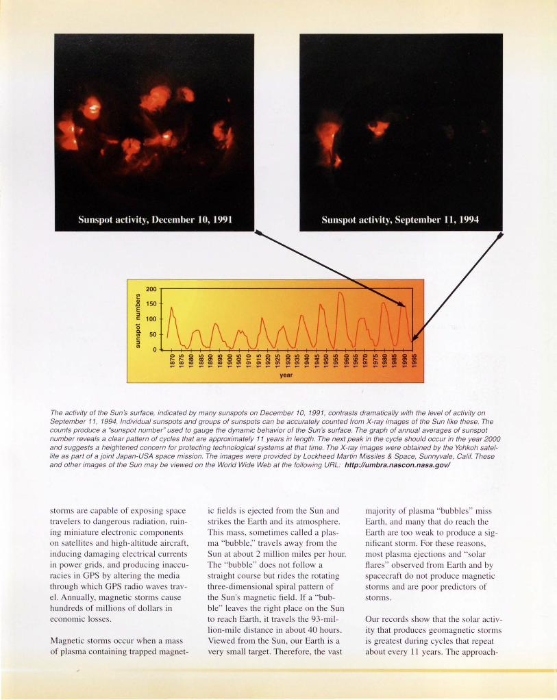
year
The activity of the Sun 's surface, indicated by many sunspots on December 10, 1991, contrasts dramatically with the level of activity on September 11, 1994. Individual sunspots and groups of sunspots can be accurately counted from X-ray images of the Sun like these. The counts produce a "sunspot number" used to gauge the dynamic behavior of the Sun's surface. The graph of annual averages of sunspot number reveals a clear pattern of cycles that are approximately 11 years in length. The next peak in the cycle should occur in the year 2000 and suggests a heightened concern for protecting technological systems at that time. The X-ray images were obtained by the Yohkoh satellite as part of a joint Japan-USA space mission. The images were provided by Lockheed Martin Missiles & Space, Sunnyvale, Calif. These and other images of the Sun may be viewed on the World Wide Web at the following URL: http://umbra.nascon.nasa.gov/
rm ur wh nama ntaining trapp d magn t-
un at ab ut 2 million mil p r hour. The ' bubble do n t follow a
but rid
li on-mi l di tan e in ab ut 40 hour . Vi w d from th un, our Earth i a
ry mall targ t. Th r for , the va t
maj rit f pia ma 'bubb l . mi . arth and many that do r a h th arth ar to w ak t pr due a . ig
r a n ,
and ' lar flare arth and by . pa craft do not produ magnetic t rm and are po r predict r of torm
ur rec rd how that th olar a ti -ity that produce geomagn tic torm i great t during cycle that r p at ab ut e ry 11 y ar . Th approach-

urin p ibili - f rm 1-
t rm .
These 12 X-ray images of the Sun 's atmosphere, obtained between 1991 and 1995 at 90-day increments, provide a dramatic view of how solar activity changes during the waning part of the solar cycle. The X-ray images reveal a bright glow for the corona and a black disk for the surface of the sun. Solar "sunspot" activity throughout the cycle is readily apparent.
The solar X-ray images are from the joint Japan-USA Yohkoh satellite mission of the Institute of Space and Astronomical Science, Japan. The images were provided by Lockheed Martin Missiles & Space, Sunnyvale, Calif.
See "The Changing Sun," by G.L. Slater and G.A. Linford at the following URL: http://www.space.lockheed.com/SXT/
For ate/lite. :
t m.
IIi t m nit ri n f r
th b t tim t a lju. t rbit r r drao
For e/ectri a/ power:
• di , r link: b t grid
mati n-nd har-
• d Ia p r . tati on maint nan and quipm nt r pia m nt
For communication
• lo k for a ll rnati fr qu n ' i
• plan m an and timin n 1
mi z mmuni ati ns
For aerial navigation:
• adju t Ai ght altitud n p tar r ut t minimi z h alth hazard
For urveying:
For space flight:
• d lay a ti itie u h a .. pa e wa lk. that ri . k expo ing a. tr -naut to radi ation
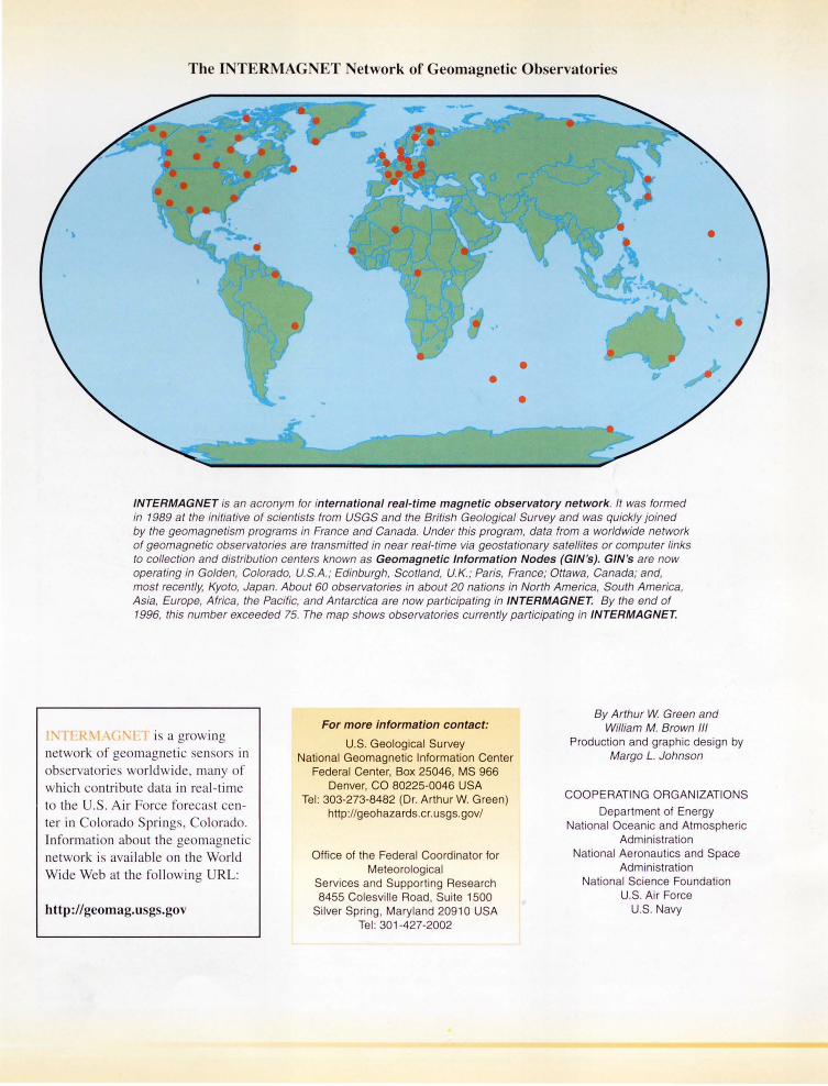
The INTERMAGNET Network of Geomagnetic Observatorie
INTERMAGNET is an acronym for international real-time magnetic observatory network. It was formed in 1989 at the initiative of scientists from USGS and the British Geological Survey and was quickly joined by the geomagnetism programs in France and Canada. Under this program, data from a worldwide network of geomagnetic observatories are transmitted in near real-time via geostationary satellites or computer links to collection and distribution centers known as Geomagnetic Information Nodes {GIN 's). GIN's are now operating in Golden, Colorado, U.S.A. ; Edinburgh, Scotland, U.K. ; Paris, France; Ottawa, Canada; and, most recently, Kyoto, Japan. About 60 observatories in about 20 nations in North America, South America, Asia, Europe, Africa, the Pacific, and Antarctica are now participating in INTERMAGNET. By the end of 1996, this number exceeded 75. The map shows observatories currently participating in INTERMAGNET.
t r in ol rado pring , Information about th g magneti n twork i a ail abl on the World Wid Web at the following RL:
http://geomag.u gs.gov
For more information contact:
U.S. Geological Survey National Geomagnetic Information Center
Federal Center, Box 25046, MS 966 Denver, CO 80225-0046 USA
Tel : 303-273-8482 (Dr. Arthur W. Green) http://geohazards.cr. usgs.gov/
Office of the Federal Coordinator for Meteorological
Services and Supporting Research 8455 Colesville Road , Suite 1500
Silver Spring Maryland 20910 USA Tel : 301-427-2002
By Arthur W Green and William M. Brown Ill
Production and graphic design by Margo L. Johnson
COOPERATING ORGANIZATIONS
Department of Energy National Oceanic and Atmospheric
Administration National Aeronautics and Space
Administration National Science Foundation
U.S. Air Force U.S. Navy