
Redressing the Municipal Affairs with Digital Spatial Data toward Responsible Land Governance
26
https://www.conftool.com/landandpoverty2017/index.php?page=browseSessions&abstracts=show&navbar_search=Shamsuddin+Ahmed &presentations=show&search=Shamsuddin+Ahmed Abstract: This research offers a basis for spatial data management case in point that the land governance strategy denoting as a routine of digital spatial data legacy development is a major stipulation to the “land resources” and the “community services”. Until 2015, Ontario’s municipalities cover just 17 percent of its landmass where the municipal affairs pace complications in land use reckoned to the seven provincial plans. The Greater Golden Horseshoe Growth Plan often cloaks the multijurisdictional constraints, for example, the amendment of the municipal zoning ordinance, land registry and surveys, land claims and conciliations, and housing options and taxations. The emphasis is to contour: first, identification of the key attributes and entity- sets; second, structuring of the geo-relational database connecting the local activities at the dissemination areas; and finally, the thematic features of each municipality and their contiguity. On the contrary, responsible land governance in municipal affairs is obviously substance at least to the three central obligations such as approach in integrated land management, shared periphery negotiation for economic and environmental growth moratoria, and digital data automation properties and protocols. The suggestion is that a massive development of digital spatial data is necessary to readdress the municipal affairs toward responsible land governance.
-
Upload
shamsuddin-ahmed -
Category
Leadership & Management
-
view
42 -
download
2
Transcript of Redressing the Municipal Affairs with Digital Spatial Data toward Responsible Land Governance
https://www.conftool.com/landandpoverty2017/index.php?page=browseSessions&abstracts=show&navbar_search=Shamsuddin+Ahmed&presentations=show&search=Shamsuddin+Ahmed
Abstract: This research offers a basis for spatial data management case in point that the land governance
strategy denoting as a routine of digital spatial data legacy development is a major stipulation to the “land
resources” and the “community services”. Until 2015, Ontario’s municipalities cover just 17 percent of its
landmass where the municipal affairs pace complications in land use reckoned to the seven provincial plans.
The Greater Golden Horseshoe Growth Plan often cloaks the multijurisdictional constraints, for example, the
amendment of the municipal zoning ordinance, land registry and surveys, land claims and conciliations, and
housing options and taxations. The emphasis is to contour: first, identification of the key attributes and entity-
sets; second, structuring of the geo-relational database connecting the local activities at the dissemination
areas; and finally, the thematic features of each municipality and their contiguity. On the contrary, responsible
land governance in municipal affairs is obviously substance at least to the three central obligations such as
approach in integrated land management, shared periphery negotiation for economic and environmental
growth moratoria, and digital data automation properties and protocols. The suggestion is that a massive
development of digital spatial data is necessary to readdress the municipal affairs toward responsible land
governance.
Redressing the Municipal Affairs with Digital
Spatial Data toward Responsible Land Governance
INTRODUCTION
DATA AND METHODOLOGY
MUNICIPAL AFFAIRS AND RESPONSIBLE
LAND GOVERNANCE
DIGITAL SPATIAL DATA: MANAGEMENT
PROPERTIES AND PROTOCOLS
CONCLUSIONS
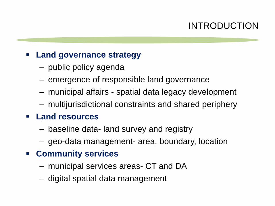
INTRODUCTION
Land governance strategy
– public policy agenda
– emergence of responsible land governance
– municipal affairs - spatial data legacy development
– multijurisdictional constraints and shared periphery
Land resources
– baseline data- land survey and registry
– geo-data management- area, boundary, location
Community services
– municipal services areas- CT and DA
– digital spatial data management
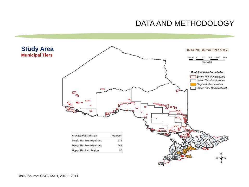
DATA AND METHODOLOGY
Study Area Municipal Tiers
Task / Source: CSC / MAH, 2010 - 2011
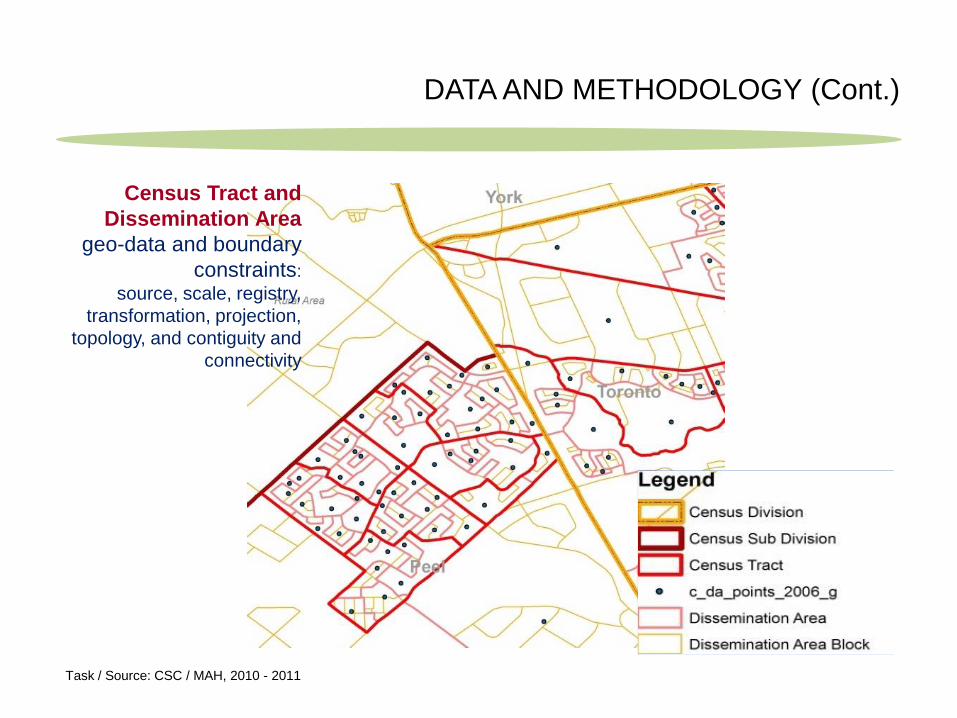
DATA AND METHODOLOGY (Cont.)
Census Tract and
Dissemination Area
geo-data and boundary
constraints:
source, scale, registry,
transformation, projection,
topology, and contiguity and
connectivity
Task / Source: CSC / MAH, 2010 - 2011
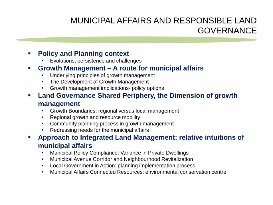
Policy and Planning context • Evolutions, persistence and challenges
Growth Management – A route for municipal affairs • Underlying principles of growth management
• The Development of Growth Management
• Growth management implications- policy options
Land Governance Shared Periphery, the Dimension of growth
management • Growth Boundaries: regional versus local management
• Regional growth and resource mobility
• Community planning process in growth management
• Redressing needs for the municipal affairs
Approach to Integrated Land Management: relative intuitions of
municipal affairs • Municipal Policy Compliance: Variance in Private Dwellings
• Municipal Avenue Corridor and Neighbourhood Revitalization
• Local Government in Action: planning implementation process
• Municipal Affairs Connected Resources: environmental conservation centre
MUNICIPAL AFFAIRS AND RESPONSIBLE LAND
GOVERNANCE
MUNICIPAL AFFAIRS AND RESPONSIBLE LAND
GOVERNANCE (Cont.)
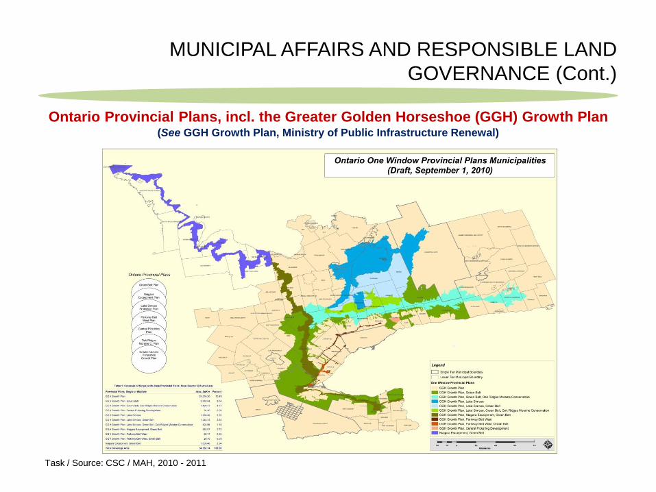
Ontario Provincial Plans, incl. the Greater Golden Horseshoe (GGH) Growth Plan (See GGH Growth Plan, Ministry of Public Infrastructure Renewal)
Task / Source: CSC / MAH, 2010 - 2011
MUNICIPAL AFFAIRS AND RESPONSIBLE LAND
GOVERNANCE (Cont.)
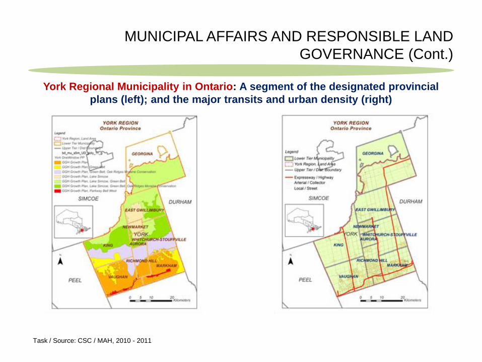
York Regional Municipality in Ontario: A segment of the designated provincial
plans (left); and the major transits and urban density (right)
Task / Source: CSC / MAH, 2010 - 2011
MUNICIPAL AFFAIRS AND RESPONSIBLE LAND
GOVERNANCE (Cont.)
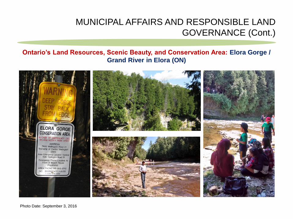
Ontario’s Land Resources, Scenic Beauty, and Conservation Area: Elora Gorge /
Grand River in Elora (ON)
Photo Date: September 3, 2016
MUNICIPAL AFFAIRS AND RESPONSIBLE LAND
GOVERNANCE (Cont.)
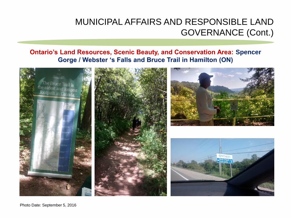
Photo Date: September 5, 2016
Ontario’s Land Resources, Scenic Beauty, and Conservation Area: Spencer
Gorge / Webster ‘s Falls and Bruce Trail in Hamilton (ON)
MUNICIPAL AFFAIRS AND RESPONSIBLE LAND
GOVERNANCE (Cont.)
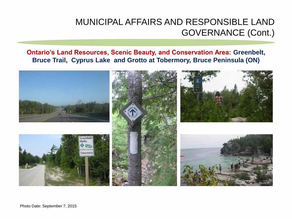
Photo Date: September 7, 2015
Ontario’s Land Resources, Scenic Beauty, and Conservation Area: Greenbelt,
Bruce Trail, Cyprus Lake and Grotto at Tobermory, Bruce Peninsula (ON)

MUNICIPAL AFFAIRS AND RESPONSIBLE LAND
GOVERNANCE (Cont.)
Smart Growth Management, a measure of responsible land governance in municipal affairs
Smart Growth Measure/Program
Techniques and methods Policy Options: Acts and Regulations
Digital Spatial Data: Physical features
Open space conservation
Regulatory control (e.g., environmental restrictions, zoning controls, and transfer of development rights)
Easement and deed restrictions
Tax incentives and Land Acquisition
Federal statutes
Provincial legislation
Municipal Acts
Crown Lands Act
By-Laws
Dissemination Area (revenue jurisdiction)
Growth Plans
Municipal Boundaries
Lands parcels
Growth boundaries Local urban growth boundaries
Regional urban growth boundaries
Local and Regional Municipalities
Stakeholders’ participations
Municipal boundaries
Conservation Area
Transits
Compact developments
Traditional neighbourhood developments
Transit-oriented developments
Transit villages
Federal Statues
Municipal Acts
Zoning By-Laws
Local community areas
Aboriginal habitats
Agriculture lands and transits
Revitalization of older areas
Downtown and main street development program
Brownfield redevelopment
Grey-field development
Provincial Policy
Community Improvement Plans
Municipal Acts
Environmental Laws
Planning area
Recreation and service centres
Housing and occupants
Heritages
Public transit Local transit programs
Regional transit programs
Environmental Acts
Transportation Policy
Road network and buffer areas
Regional planning coordination
Regional Government
Regional authorities
Regional infrastructure service districts
State planning initiatives
Growth Management Negotiation
Cross-boundary policy issues
Federal Statutes
Multijurisdictional municipal boundaries
Growth Management Criteria
Sectoral Attributes
Source: Adapted from Beyea, Geith & McKeown (2009).
Key Considerations
Digital Spatial Data Entity-Relationship
Multi-party Negotiation for Economic and
Environmental Growth Moratoria
Digital Spatial data implementation properties
and protocol
DIGITAL SPATIAL DATA: MANAGEMENT PROTOCOLS AND
PROPERTIES
DIGITAL SPATIAL DATA: MANAGEMENT PROTOCOLS AND
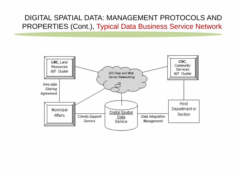
PROPERTIES (Cont.), Typical Data Business Service Network
DIGITAL SPATIAL DATA: MANAGEMENT PROTOCOLS AND
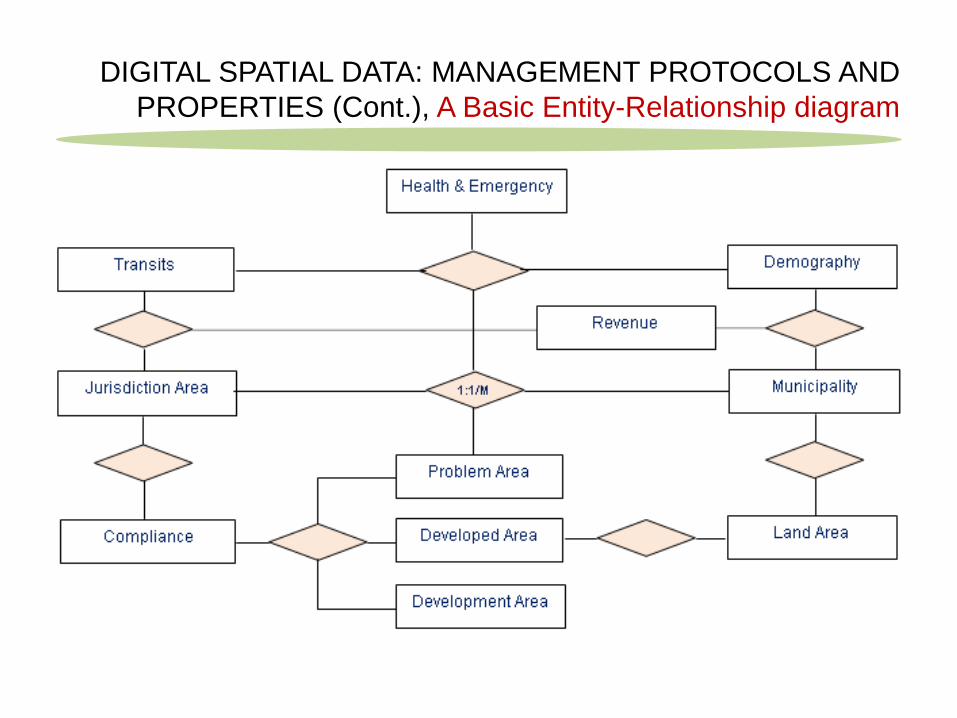
PROPERTIES (Cont.), A Basic Entity-Relationship diagram
DIGITAL SPATIAL DATA: MANAGEMENT PROTOCOLS AND
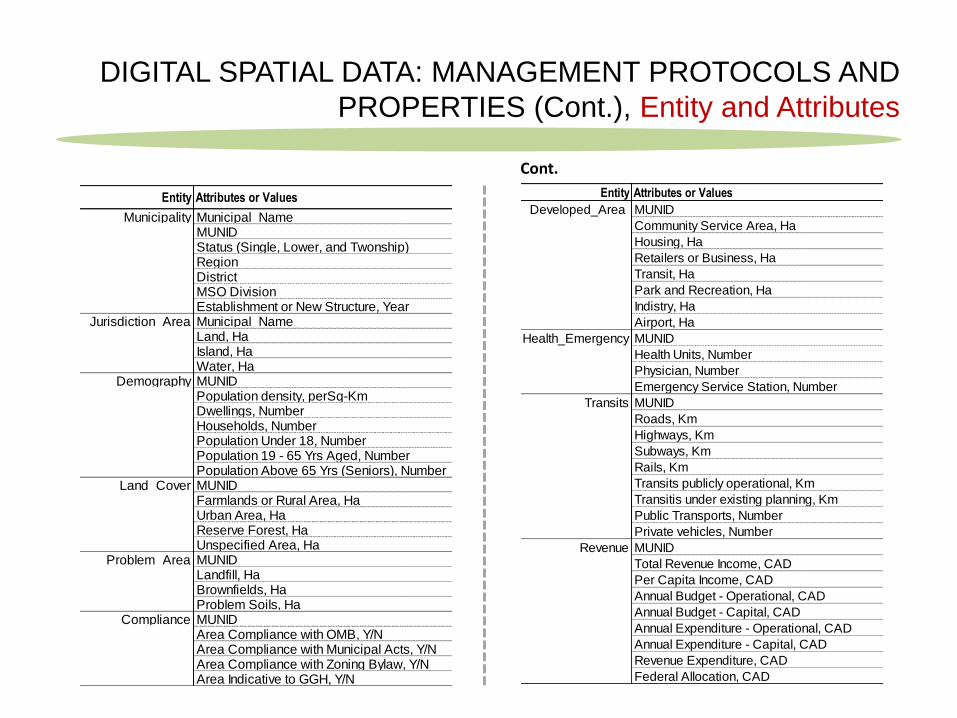
PROPERTIES (Cont.), Entity and Attributes
Entity Attributes or Values
Municipality Municipal_NameMUNIDStatus (Single, Lower, and Twonship)RegionDistrictMSO DivisionEstablishment or New Structure, Year
Jurisdiction_Area Municipal_NameLand, HaIsland, HaWater, Ha
Demography MUNIDPopulation density, perSq-KmDwellings, NumberHouseholds, NumberPopulation Under 18, NumberPopulation 19 - 65 Yrs Aged, NumberPopulation Above 65 Yrs (Seniors), Number
Land_Cover MUNIDFarmlands or Rural Area, HaUrban Area, HaReserve Forest, HaUnspecified Area, Ha
Problem_Area MUNIDLandfill, HaBrownfields, HaProblem Soils, Ha
Compliance MUNIDArea Compliance with OMB, Y/NArea Compliance with Municipal Acts, Y/NArea Compliance with Zoning Bylaw, Y/NArea Indicative to GGH, Y/N
Entity Attributes or Values
Developed_Area MUNID
Community Service Area, Ha
Housing, Ha
Retailers or Business, Ha
Transit, Ha
Park and Recreation, Ha
Indistry, Ha
Airport, Ha
Health_Emergency MUNID
Health Units, Number
Physician, Number
Emergency Service Station, Number
Transits MUNID
Roads, Km
Highways, Km
Subways, Km
Rails, Km
Transits publicly operational, Km
Transitis under existing planning, Km
Public Transports, Number
Private vehicles, Number
Revenue MUNID
Total Revenue Income, CAD
Per Capita Income, CAD
Annual Budget - Operational, CAD
Annual Budget - Capital, CAD
Annual Expenditure - Operational, CAD
Annual Expenditure - Capital, CAD
Revenue Expenditure, CAD
Federal Allocation, CAD
Cont.
DIGITAL SPATIAL DATA: MANAGEMENT PROTOCOLS AND
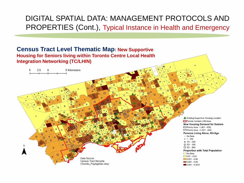
PROPERTIES (Cont.), Typical Instance in Health and Emergency
Census Tract Level Thematic Map: New Supportive
Housing for Seniors living within Toronto Centre Local Health
Integration Networking (TC/LHIN)
DIGITAL SPATIAL DATA: MANAGEMENT PROTOCOLS AND
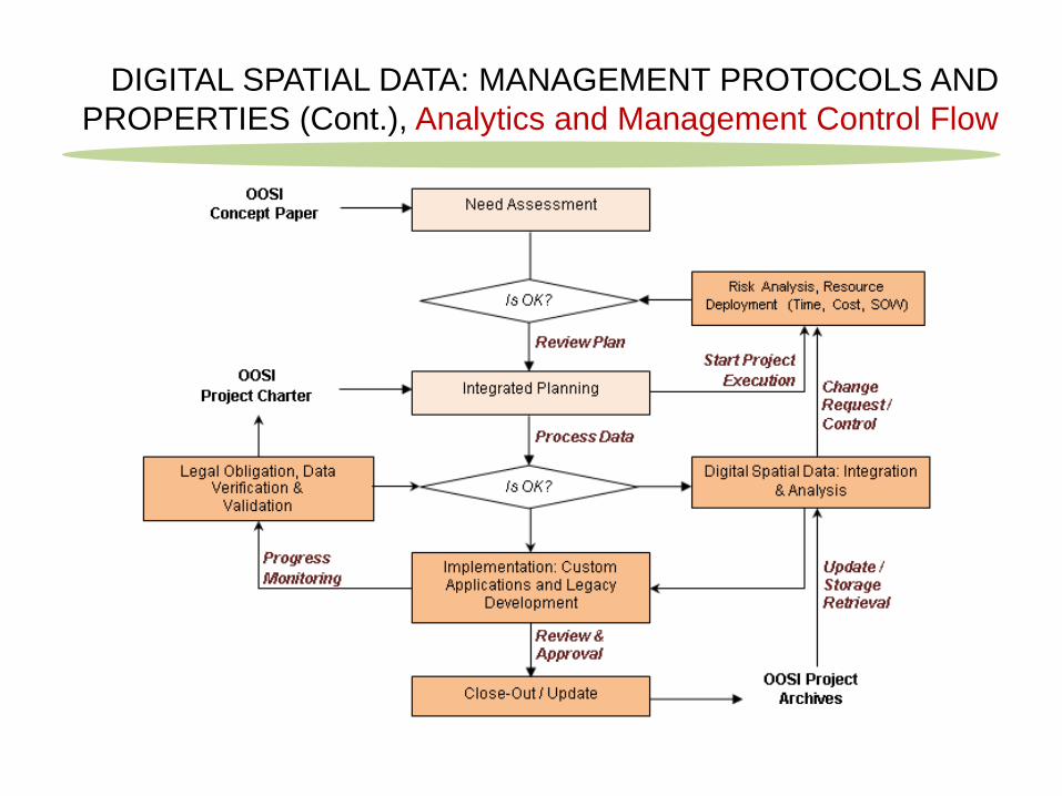
PROPERTIES (Cont.), Analytics and Management Control Flow
DIGITAL SPATIAL DATA: MANAGEMENT PROTOCOLS AND
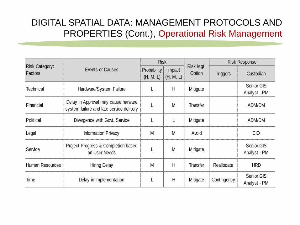
PROPERTIES (Cont.), Operational Risk Management
Technical Hardware/System Failure L H MitigateSenior GIS
Analyst - PM
FinancialDelay in Approval may cause harware
system failure and late service deliveryL M Transfer ADM/DM
Political Divergence with Govt. Service L L Mitigate ADM/DM
Legal Information Privacy M M Avoid CIO
ServiceProject Progress & Completion based
on User NeedsL M Mitigate
Senior GIS
Analyst - PM
Human Resources Hiring Delay M H Transfer Reallocate HRD
Time Delay in Implementation L H Mitigate Contingency Senior GIS
Analyst - PM
Risk Category:
FactorsEvents or Causes
RiskRisk Mgt.
Option
Risk Response
Probability
(H, M, L)Triggers Custodian
Impact
(H, M, L)
DIGITAL SPATIAL DATA: MANAGEMENT PROTOCOLS AND
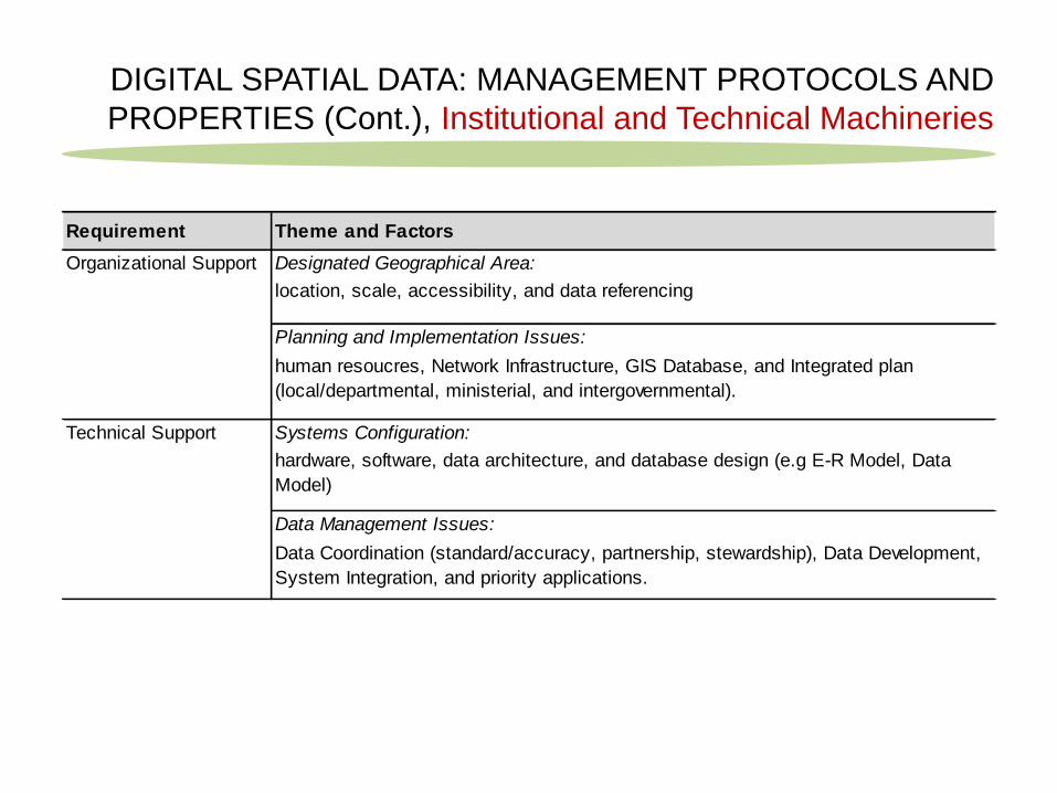
PROPERTIES (Cont.), Institutional and Technical Machineries
Requirement Theme and Factors
Designated Geographical Area:
location, scale, accessibility, and data referencing
Planning and Implementation Issues:
human resoucres, Network Infrastructure, GIS Database, and Integrated plan
(local/departmental, ministerial, and intergovernmental).
Systems Configuration:
hardware, software, data architecture, and database design (e.g E-R Model, Data
Model)
Data Management Issues:
Data Coordination (standard/accuracy, partnership, stewardship), Data Development,
System Integration, and priority applications.
Organizational Support
Technical Support
DIGITAL SPATIAL DATA: MANAGEMENT PROTOCOLS AND
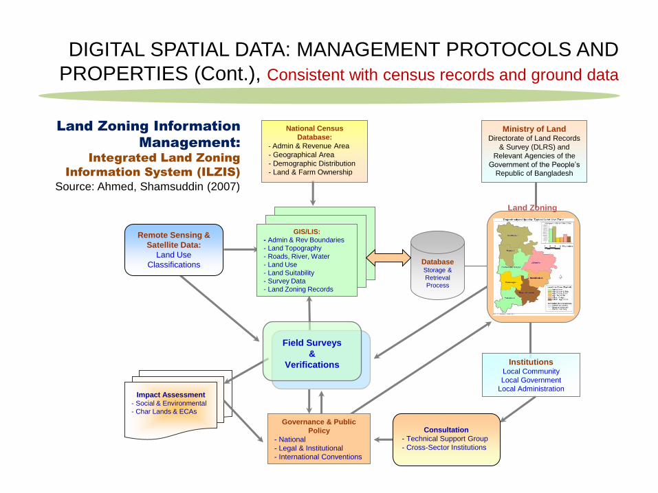
PROPERTIES (Cont.), Consistent with census records and ground data
Impact Assessment - Social & Environmental
- Char Lands & ECAs
National Census
Database:
- Admin & Revenue Area
- Geographical Area
- Demographic Distribution
- Land & Farm Ownership
GIS/LIS:
- Admin & Rev Boundaries
- Land Topography
- Roads, River, Water
- Land Use
- Land Suitability
- Survey Data
- Land Zoning Records
Database Storage &
Retrieval
Process
Institutions Local Community
Local Government
Local Administration
Ministry of Land Directorate of Land Records
& Survey (DLRS) and
Relevant Agencies of the
Government of the People’s
Republic of Bangladesh
Remote Sensing &
Satellite Data:
Land Use
Classifications
Consultation
- Technical Support Group
- Cross-Sector Institutions
Field Surveys
&
Verifications
Land Zoning
Governance & Public
Policy
- National
- Legal & Institutional
- International Conventions
Land Zoning Information
Management: Integrated Land Zoning
Information System (ILZIS)
Source: Ahmed, Shamsuddin (2007)
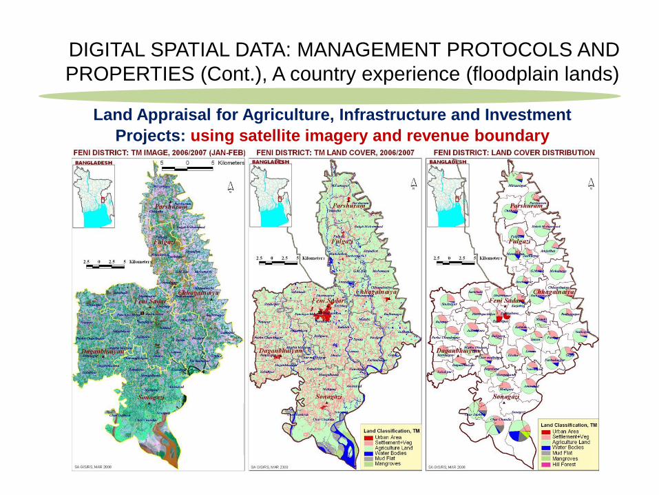
DIGITAL SPATIAL DATA: MANAGEMENT PROTOCOLS AND
PROPERTIES (Cont.), A country experience (floodplain lands)
Land Appraisal for Agriculture, Infrastructure and Investment
Projects: using satellite imagery and revenue boundary

DIGITAL SPATIAL DATA: MANAGEMENT PROTOCOLS AND
PROPERTIES (Cont.), A country experience (floodplain lands)
Land Appraisal for Agriculture, Infrastructure and Investment
Projects: using census records and revenue boundary
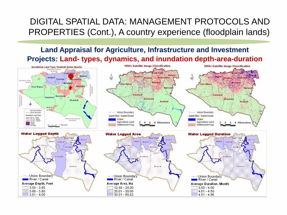
DIGITAL SPATIAL DATA: MANAGEMENT PROTOCOLS AND
PROPERTIES (Cont.), A country experience (floodplain lands)
Land Appraisal for Agriculture, Infrastructure and Investment
Projects: Land- types, dynamics, and inundation depth-area-duration
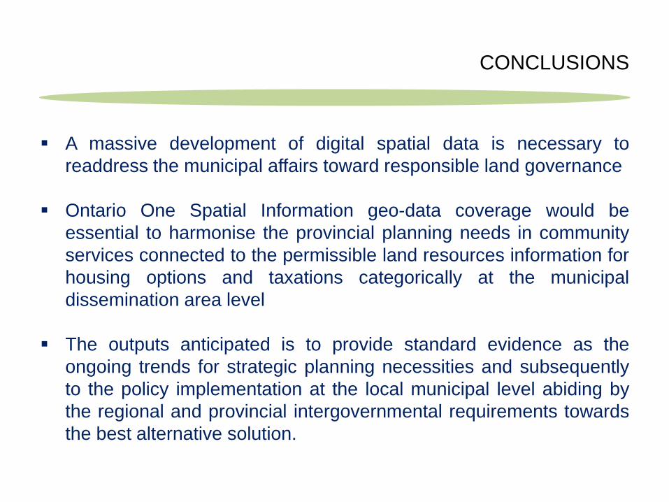
A massive development of digital spatial data is necessary to
readdress the municipal affairs toward responsible land governance
Ontario One Spatial Information geo-data coverage would be
essential to harmonise the provincial planning needs in community
services connected to the permissible land resources information for
housing options and taxations categorically at the municipal
dissemination area level
The outputs anticipated is to provide standard evidence as the
ongoing trends for strategic planning necessities and subsequently
to the policy implementation at the local municipal level abiding by
the regional and provincial intergovernmental requirements towards
the best alternative solution.
CONCLUSIONS
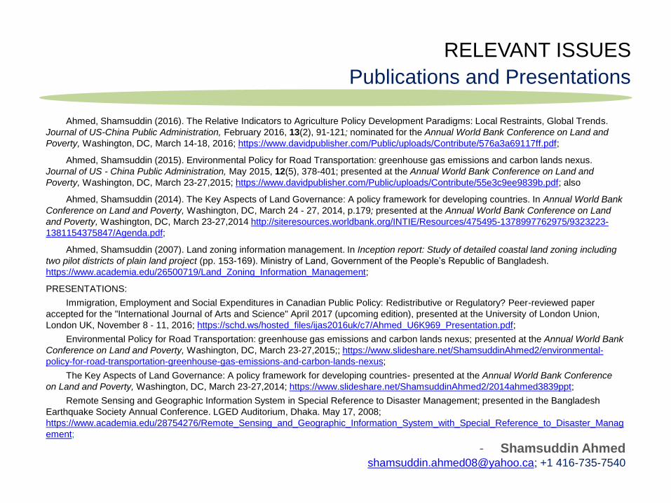
RELEVANT ISSUES
Publications and Presentations
Ahmed, Shamsuddin (2016). The Relative Indicators to Agriculture Policy Development Paradigms: Local Restraints, Global Trends.
Journal of US-China Public Administration, February 2016, 13(2), 91-121; nominated for the Annual World Bank Conference on Land and
Poverty, Washington, DC, March 14-18, 2016; https://www.davidpublisher.com/Public/uploads/Contribute/576a3a69117ff.pdf;
Ahmed, Shamsuddin (2015). Environmental Policy for Road Transportation: greenhouse gas emissions and carbon lands nexus.
Journal of US - China Public Administration, May 2015, 12(5), 378-401; presented at the Annual World Bank Conference on Land and
Poverty, Washington, DC, March 23-27,2015; https://www.davidpublisher.com/Public/uploads/Contribute/55e3c9ee9839b.pdf; also
Ahmed, Shamsuddin (2014). The Key Aspects of Land Governance: A policy framework for developing countries. In Annual World Bank
Conference on Land and Poverty, Washington, DC, March 24 - 27, 2014, p.179; presented at the Annual World Bank Conference on Land
and Poverty, Washington, DC, March 23-27,2014 http://siteresources.worldbank.org/INTIE/Resources/475495-1378997762975/9323223-
1381154375847/Agenda.pdf;
Ahmed, Shamsuddin (2007). Land zoning information management. In Inception report: Study of detailed coastal land zoning including
two pilot districts of plain land project (pp. 153-169). Ministry of Land, Government of the People’s Republic of Bangladesh.
https://www.academia.edu/26500719/Land_Zoning_Information_Management;
PRESENTATIONS:
Immigration, Employment and Social Expenditures in Canadian Public Policy: Redistributive or Regulatory? Peer-reviewed paper
accepted for the "International Journal of Arts and Science" April 2017 (upcoming edition), presented at the University of London Union,
London UK, November 8 - 11, 2016; https://schd.ws/hosted_files/ijas2016uk/c7/Ahmed_U6K969_Presentation.pdf;
Environmental Policy for Road Transportation: greenhouse gas emissions and carbon lands nexus; presented at the Annual World Bank
Conference on Land and Poverty, Washington, DC, March 23-27,2015;; https://www.slideshare.net/ShamsuddinAhmed2/environmental-
policy-for-road-transportation-greenhouse-gas-emissions-and-carbon-lands-nexus;
The Key Aspects of Land Governance: A policy framework for developing countries- presented at the Annual World Bank Conference
on Land and Poverty, Washington, DC, March 23-27,2014; https://www.slideshare.net/ShamsuddinAhmed2/2014ahmed3839ppt;
Remote Sensing and Geographic Information System in Special Reference to Disaster Management; presented in the Bangladesh
Earthquake Society Annual Conference. LGED Auditorium, Dhaka. May 17, 2008;
https://www.academia.edu/28754276/Remote_Sensing_and_Geographic_Information_System_with_Special_Reference_to_Disaster_Manag
ement;
- Shamsuddin Ahmed [email protected]; +1 416-735-7540


