Redlands Planning Scheme
65
Conservation & Open Space Position Paper May 2002 ‘balancing growth and lifestyle in the Redlands’ Redlands Planning Scheme
Transcript of Redlands Planning Scheme
Conservation & Open SpacePosition Paper
May 2002
‘balancing growth and lifestyle in the Redlands’
Redlands Planning Scheme
Conservation and Open Space
116/05/02
Table of Contents
1 Introduction 3
1.1 Background 3
1.2 Purpose of this Paper 3
1.3 Relevant Issues 4
2 Current Planning Scheme: Approach Analysis (Strengths and Weaknesses) 5
2.1 Introduction 5
2.2 Strengths 11
2.3 Weaknesses 11
3 Nature Conservation 12
3.1 Legislative Context 12
3.2 Nature Conservation within Redland Shire 18
3.3 Environmental Inventory 18
3.4 Vegetation Management 25
3.5 Koala Management 26
3.6 Coastal Issues 29
3.7 Wetlands and Waterways 31
3.8 State Agency Interests 33
4 Open Space and Recreation 49
4.1 Introduction 49
4.2 Open Space and Recreation Planning Principles 49
4.3 State Agency Interests 52
5 Summary of Planning Implications 54
5.1 Conservation 54
5.2 Open Space and Recreation 55
6 Planning Strategy Areas 56
6.1 Introduction 56

Conservation and Open Space
216/05/02
6.2 Conservation 56
6.3 Open Space and Recreation 57
7 References 58
Conservation and Open Space
316/05/02
1 Introduction
1.1 Background
The following position paper addressing conservation and open space, is one of twelve (12) position papers addressing key aspects of future land use and development policy in Redland Shire. The paper has been prepared as part of Stage 3 of the Redlands Planning Scheme project and is intended to inform the land use option identification and assessment process programmed to occur in Stage 4. The outcomes of Stage 4 will be reflected in the Redland Shire Planning SchemeStatement of Proposals due to be released in early 2002.
Planning position papers prepared as part Stage 3 are as follows:
1. Population & Demographics2. Residential Development3. Industry & Business4. Commercial & Retail Centres5. Rural6. Conservation & Open Space7. Constraints8. Environmental Management9. Cultural Heritage10. Community & Social Development 11. Transport12. Infrastructure
At the time of preparing this Position Paper, it is noted that Council is preparing a detailed Open Space and Recreation Study for the Shire. Future recreation and open space planning for the Shire will draw heavily on the findings of this Studythat is expected to be completed during Stage 2 of the Planning Scheme preparation process. In the absence of the finding of this study, recreation and open space issues have been addressed only in a generic manner having regard to available source material and State Agency input. Upon finalisation of the Open Space and Recreation Study, detailed findings will be both incorporated in the Planning Study and used to inform the drafting of the Planning Scheme in Stage 2 of the project.
1.2 Purpose of this Paper
In planning for the future growth and land use within the Shire, the ability to balance development with the need to conserve key natural, habitat and recreational values will assume increasing importance.
Many areas of Redland Shire are characterised by high nature conservation and recreational values, including:
! Flora and fauna species which are threatened, rare and/or significant;
! Ecosystems or remnants of ecosystems of state, regional, and/or local government significance.
Conservation and Open Space
416/05/02
In seeking to achieve ‘ecological sustainability’1 the Planning scheme must play a pivotal role in maintaining biodiversity and in protecting areas of natural value. The provision of a full range of active and passive recreation opportunities is also critical in meeting the needs of the shire’s resident and tourist population. In many instances the protection of the natural and recreational values are closely linked.
This paper seeks to:
! identify and examine the Shire’s key conservation and recreation resources;
! assess the community values associated with conservation and recreation; and
! consider land use and growth management approaches relevant to Nature Conservation and recreation management.
1.3 Relevant Issues
The following paper considers a range of issues relevant to conservation in the Shire. These include:
• The legislative context applicable to nature conservation in the Shire including relevant statutory obligations under Federal and State legislation.
• The need to conserve, protect and enhance areas of Federal, State, regional and Local significance from incompatible land use activities that have the potential to have an adverse impact on the environmental values of such areas.
• The need to identify planning scheme mechanisms capable of protecting significant environmental, habitat, and landscape values.
• The need for coordinated approaches to conservation and recreation management.
• Remnant habitat, vegetation, and wildlife management (land use issues associated with both “on” and “off-reserve”management).
• Environmental linkages (including wildlife corridors)
• Waterway and wetland management.
• Management of impacts on the marine environment.
1 as defined under 1.3.3 of the Integrated Planning Act 1997
Conservation and Open Space
516/05/02
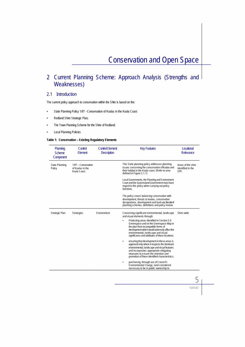
2 Current Planning Scheme: Approach Analysis (Strengths andWeaknesses)
2.1 Introduction
The current policy approach to conservation within the Shire is based on the:
• State Planning Policy 1/97 - Conservation of Koalas in the Koala Coast
• Redland Shire Strategic Plan;
• The Town Planning Scheme for the Shire of Redland;
• Local Planning Policies
Table 1: Conservation – Existing Regulatory Elements
PlanningScheme
Component
ControlElement
Control Element Description
Key Features LocationalRelevance
State Planning Policy
1/97 – Conservation of Koalas in the Koala Coast
This State planning policy addresses planning issues concerning the conservation of Koalas and their habitat in the Koala coast. (Refer to area defined in Figure 2.1.1)
Local Governments, the Planning and Environment Court and the Queensland Government must have regard to this policy when carrying out policy functions.
The policy covers balancing conservation with development, threats to koalas, conservation designations, development and land-use, the role of planning schemes, definitions and policy review.
Areas of the shire identified in the SPP.
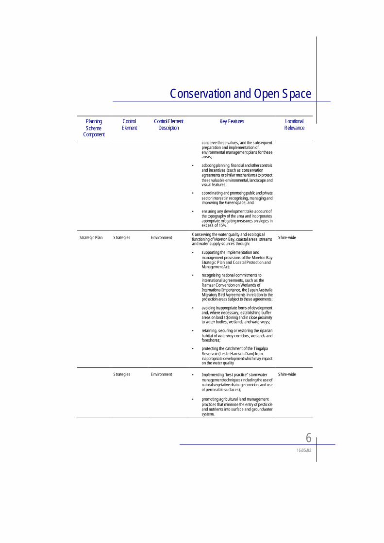
Strategic Plan Strategies Environment Conserving significant environmental, landscape and visual elements through:
• Protecting areas identified in Section 5.0 Greenspace and on the Greenspace Map in the plan from incompatible forms of development which would adversely affect the environmental, landscape and visual significance and attributes of these locations;
• ensuring that development in these areas is approved only where it respects the dominant environmental, landscape and visual features and incorporates appropriate mitigating measures to ensure the retention and promotion of these identified characteristics;
• purchasing, through use of Council’s Environmental Charge, land considered necessary to be in public ownership to
Shire-wide
Conservation and Open Space
616/05/02
PlanningScheme
Component
ControlElement
Control Element Description
Key Features LocationalRelevance
conserve these values, and the subsequent preparation and implementation of environmental management plans for these areas;
• adopting planning, financial and other controls and incentives (such as conservation agreements or similar mechanisms) to protect these valuable environmental, landscape and visual features;
• coordinating and promoting public and private sector interest in recognising, managing and improving the Greenspace; and
• ensuring any development take account of the topography of the area and incorporates appropriate mitigating measures on slopes in excess of 15%.
Strategic Plan Strategies EnvironmentConserving the water quality and ecological functioning of Moreton Bay, coastal areas, streams and water supply sources through:
• supporting the implementation and management provisions of the Moreton Bay Strategic Plan and Coastal Protection and Management Act;
• recognising national commitments to international agreements, such as the Ramsar Convention on Wetlands of International Importance, the Japan Australia Migratory Bird Agreements in relation to the protection areas subject to these agreements;
• avoiding inappropriate forms of development and, where necessary, establishing buffer areas on land adjoining and in close proximity to water bodies, wetlands and waterways;
• retaining, securing or restoring the riparianhabitat of waterway corridors, wetlands and foreshores;
• protecting the catchment of the Tingalpa Reservoir (Leslie Harrison Dam) from inappropriate development which may impact on the water quality
Shire-wide
Strategies Environment • Implementing “best practice” stormwater management techniques (including the use of natural vegetative drainage corridors and use of permeable surfaces);
• promoting agricultural land management practices that minimise the entry of pesticide and nutrients into surface and g roundwatersystems.
Shire-wide
Conservation and Open Space
716/05/02
PlanningScheme
Component
ControlElement
Control Element Description
Key Features LocationalRelevance
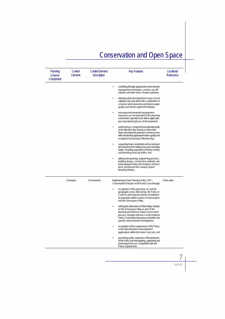
• controlling through appropriate environmental management techniques, erosion, run-off,siltation and other forms of water pollution;
• allowing urban development in areas of acid sulphate soils only where this is undertaken in a manner which prevents any threat to water quality and marine organisms/habitats;
• ensuring environmental management measures are incorporated in the planning construction, operation and, where applicable, post-operational phases of development;
• undertaking a comprehensive planning study of the Moreton Bay Islands to determine future development potential commensurate with maintaining appropriate water quality and ecological functioning of Moreton Bay;
• separating future residential and recreational development from biting insect pest breeding habits, including separation of human activity and breeding areas by buffer; and
• utilising site planning, engineering practices, building design, construction methods and landscaping to reduce the incidence of insect pests and prevent the creation of pest breeding habitat.
Strategies Environment Implementing State Planning Policy 1/97 –Conservation of koalas in the Koala Coast through:
• recognition of the provisions of, and the geographic areas affected by, the Policy in Council’s planning documents including its incorporation within section 5.0 Greenspace and the Greenspace Map;
• refining the delineation of Other Major Habitat on the Greenspace Map as part of the planning and land use impact assessment process, through reference to the Redland Shire’s Environment Inventory and further site specific environmental investigations;
• recognition of the requirements of the Policy in the determination of development applications within the Koala Coast are; and
• promoting public awareness of the provisions of the Policy and investigating, supporting and promoting land uses compatible with the Policy requirements.
Shire-wide
Conservation and Open Space
816/05/02
PlanningScheme
Component
ControlElement
Control Element Description
Key Features LocationalRelevance
EcologicallySustainableDevelopment
The overriding aim of the Strategic Plan to achieve orderly and ecologically sustainable development in the Shire involves adoption of an environmentally sound approach to development and a decision making process which integrates long and short term economic, environmental, social and equity considerations. Ecologically sustainabledevelopment will be achieved in the Shire by:
• adopting a compact urban form which does not intrude on sensitive environmental areas of the Shire through:
• identifying areas considered of significant environmental, landscape and visual value on the Greenspace Map;
• adopting appropriate planing controls to exclude further large scale or intensive urban development activities from most areas identified on the Greenspace Map;
• promoting an increase in residential densities in new development in existing urban areas and on Greenfield sites through adoption of the principles of the Australian Model Code for Residential Development (AMCORD);
• limiting the extent of larger lot residential development (such as Residential Low Density and Park Residential deve lopment)throughout the Shire; and
• restricting future urban development to areas which represent orderly and logical extensions to the existing urban settlement pattern.
Shire-wide
Preferred Dominant Land Use
Public Open Space This designation indicates the location of areas which are currently in public ownership or are expected to come under Council control for use for parks and recreation purposes.
These areas are intended to perform a role in meeting the recreational needs of Shire residents for active and passive recreational pursuits. It is also intended to recognise the importance of these areas in many locations for environmental functions such as waterway preservation, maintenance of fauna habitat and/or corridor and coastal protection/buffering from land uses which would impact on the value of these areas.
Shire-wide
Preferred Dominant Land Use
Special Protection Area
Designates areas within the urban areas of the Shire possessing environmental qualities worthy of preservation and enhancement.
Urban ares of the Shire
Conservation and Open Space
916/05/02
PlanningScheme
Component
ControlElement
Control Element Description
Key Features LocationalRelevance
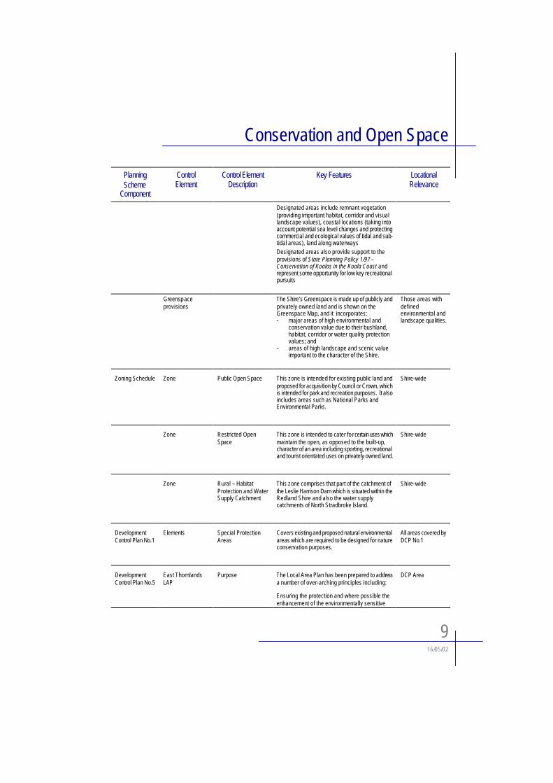
Designated areas include remnant vegetation (providing important habitat, corridor and visual landscape values), coastal locations (taking into account potential sea level changes and protecting commercial and ecological values of tidal and sub-tidal areas), land along waterwaysDesignated areas also provide support to the provisions of State Planning Policy 1/97 –Conservation of Koalas in the Koala Coast and represent some opportunity for low key recreational pursuits
Greenspaceprovisions
The Shire’s Greenspace is made up of publicly and privately owned land and is shown on the Greenspace Map, and it incorporates:- major areas of high environmental and
conservation value due to their bushland, habitat, corridor or water quality protection values; and
- areas of high landscape and scenic value important to the character of the Shire.
Those areas with definedenvironmental and landscape qualities.
Zoning Schedule Zone Public Open Space This zone is intended for existing public land and proposed for acquisition by Council or Crown, which is intended for park and recreation purposes. It also includes areas such as National Parks and Environmental Parks.
Shire-wide
Zone Restricted Open Space
This zone is intended to cater fo r certain uses which maintain the open, as opposed to the built-up,character of an area including sporting, recreational and tourist orientated uses on privately owned land.
Shire-wide
Zone Rural – Habitat Protection and Water Supply Catchment
This zone comprises that part of the catchment of the Leslie Harrison Dam which is situated within the Redland Shire and also the water supply catchments of North Stradbroke Island.
Shire-wide
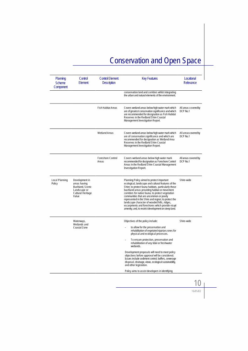
DevelopmentControl Plan No.1
Elements Special Protection Areas
Covers existing and proposed natural environmental areas which are required to be designed for nature conservation purposes.
All areas covered by DCP No.1
DevelopmentControl Plan No.5
East Thornlands LAP
Purpose The Local Area Plan has been prepared to addressa number of over-arching principles including:
Ensuring the protection and where possible the enhancement of the environmentally sensitive
DCP Area
Conservation and Open Space
1016/05/02
PlanningScheme
Component
ControlElement
Control Element Description
Key Features LocationalRelevance
conservation land and corridors whilst integrating the urban and natural elements of the environment.
Fish Habitat Areas Covers wetland areas below high water mark which are of greatest conservation significance and which are recommended for designation as Fish Habitat Reserves in the Redland Shire Coastal Management Investigation Report.
All areas covered by DCP No.1
Wetland Areas Covers wetland areas below high water mark which are of conservation significance and which are recommended for designation as Wetland Area Reserves in the Redland Shire Coastal Management Investigation Report.
All areas covered by DCP No.1
Foreshore Control Areas
Covers wetland areas below high water mark recommended for designation as Foreshore Control Areas in the Redland Shire Coastal Management Investigation Report.
All areas covered by DCP No.1
Local Planning Policy
Development in areas having Bushland, Scenic Landscape or Cultural Heritage Value
Planning Policy aimed to protect important ecological, landscape and cultural features of the Shire; to protect fauna habitats, particularly those bushland areas providing habitat or movement corridors for native fauna; to protect vegetation communities that are uncommon or poorly represented in the Shire and region; to protect the landscape character of wooded hills, ridges, escarpments and foreshores which provide visualamenity; and, to restrict development on steep land.
Shire-wide
Waterways,Wetlands and Coastal Zone
Objectives of the policy include:
- to allow for the preservation and rehabilitation of vegetated riparian zones for physical and ecological processes.
- To ensure protection, preservation and rehabilitation of any tidal or freshwater wetlands.
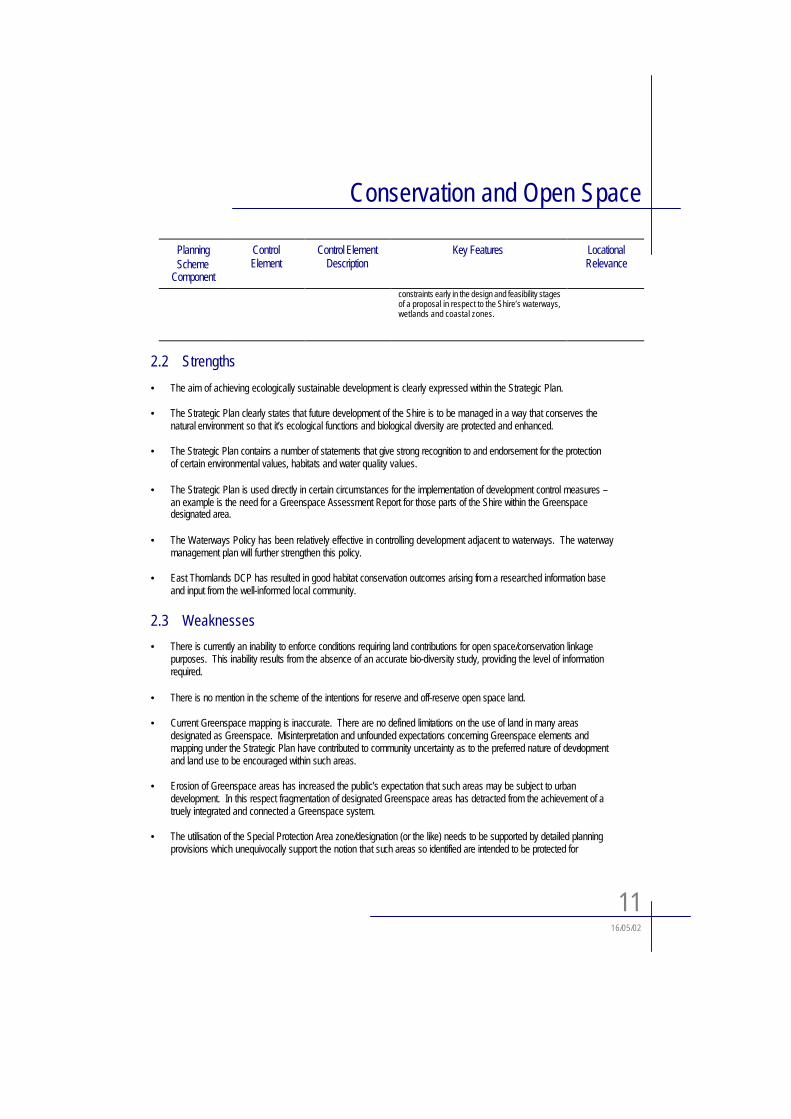
Development proposals will need to meet policy objectives before approval will be considered.Issues include sediment control, buffers, sewerage disposal, drainage, views, ecological sustainability, and other legislation.
Policy aims to assist developers in identifying
Shire-wide
Conservation and Open Space
1116/05/02
PlanningScheme
Component
ControlElement
Control Element Description
Key Features LocationalRelevance
constraints early in the design and feasibility stages of a proposal in respect to the Shire’s waterways, wetlands and coastal zones.
2.2 Strengths
• The aim of achieving ecologically sustainable development is clearly expressed within the Strategic Plan.
• The Strategic Plan clearly states that future development of the Shire is to be managed in a way that conserves the natural environment so that it’s ecological functions and biological diversity are protected and enhanced.
• The Strategic Plan contains a number of statements that give strong recognition to and endorsement for the protection of certain environmental values, habitats and water quality values.
• The Strategic Plan is used directly in certain circumstances for the implementation of development control measures –an example is the need for a Greenspace Assessment Report for those parts of the Shire within the Greenspace designated area.
• The Waterways Policy has been relatively effective in controlling development adjacent to waterways. The waterway management plan will further strengthen this policy.
• East Thornlands DCP has resulted in good habitat conservation outcomes arising from a researched information base and input from the well-informed local community.
2.3 Weaknesses
• There is currently an inability to enforce conditions requiring land contributions for open space/conservation linkage purposes. This inability results from the absence of an accurate bio-diversity study, providing the level of information required.
• There is no mention in the scheme of the intentions for reserve and off-reserve open space land.
• Current Greenspace mapping is inaccurate. There are no defined limitations on the use of land in many areas designated as Greenspace. Misinterpretation and unfounded expectations concerning Greenspace elements and mapping under the Strategic Plan have contributed to community uncertainty as to the preferred nature of developmentand land use to be encouraged within such areas.
• Erosion of Greenspace areas has increased the public’s expectation that such areas may be subject to urban development. In this respect fragmentation of designated Greenspace areas has detracted from the achievement of a truely integrated and connected a Greenspace system.
• The utilisation of the Special Protection Area zone/designation (or the like) needs to be supported by detailed planning provisions which unequivocally support the notion that such areas so identified are intended to be protected for
Conservation and Open Space
1216/05/02
environmental conservation purposes. Lands included with such designation would include areas of remnant vegetation which provide important habitat, corridor and visual landscape values.
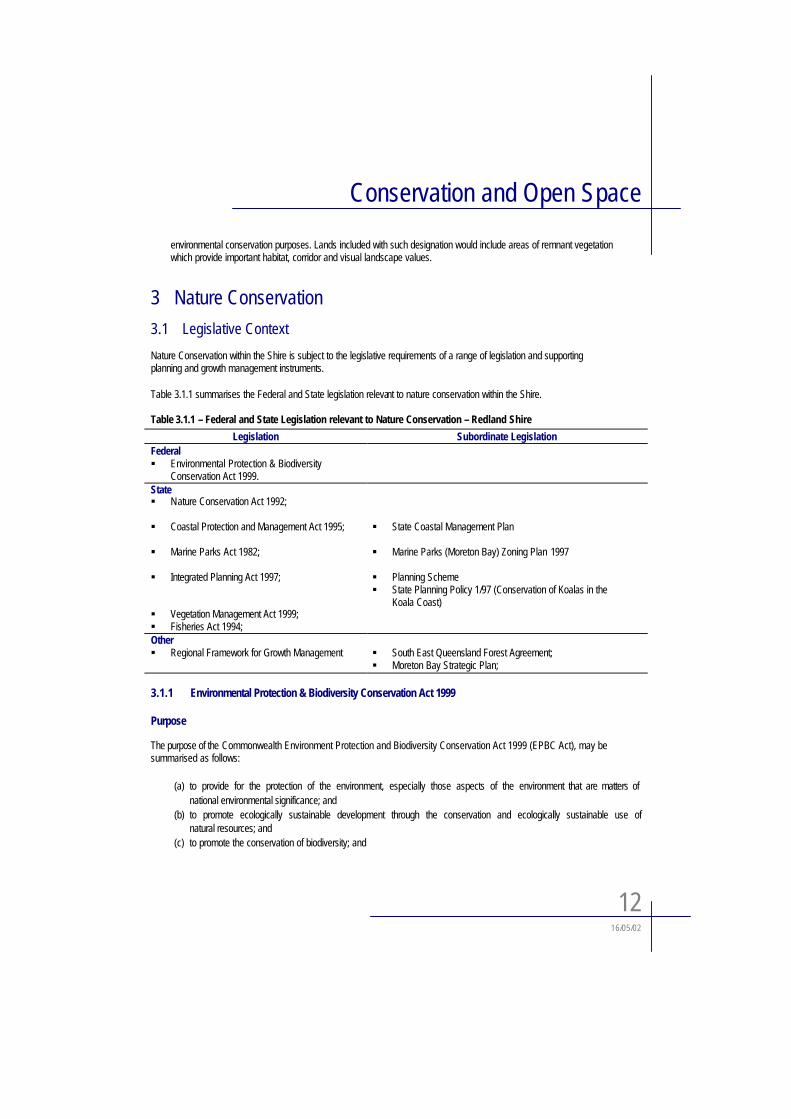
3 Nature Conservation
3.1 Legislative Context
Nature Conservation within the Shire is subject to the legislative requirements of a range of legislation and supporting planning and growth management instruments.
Table 3.1.1 summarises the Federal and State legislation relevant to nature conservation within the Shire.
Table 3.1.1 – Federal and State Legislation relevant to Nature Conservation – Redland Shire
Legislation Subordinate LegislationFederal! Environmental Protection & Biodiversity
Conservation Act 1999.State! Nature Conservation Act 1992;
! Coastal Protection and Management Act 1995;
! Marine Parks Act 1982;
! Integrated Planning Act 1997;
! Vegetation Management Act 1999;! Fisheries Act 1994;
! State Coastal Management Plan
! Marine Parks (Moreton Bay) Zoning Plan 1997
! Planning Scheme! State Planning Policy 1/97 (Conservation of Koalas in the
Koala Coast)
Other! Regional Framework for Growth Management ! South East Queensland Forest Agreement;
! Moreton Bay Strategic Plan;
3.1.1 Environmental Protection & Biodiversity Conservation Act 1999
Purpose
The purpose of the Commonwealth Environment Protection and Biodiversity Conservation Act 1999 (EPBC Act), may be summarised as follows:
(a) to provide for the protection of the environment, especially those aspects of the environment that are matters of national environmental significance; and
(b) to promote ecologically sustainable development through the conservation and ecologically sustainable use ofnatural resources; and
(c) to promote the conservation of biodiversity; and
Conservation and Open Space
1316/05/02
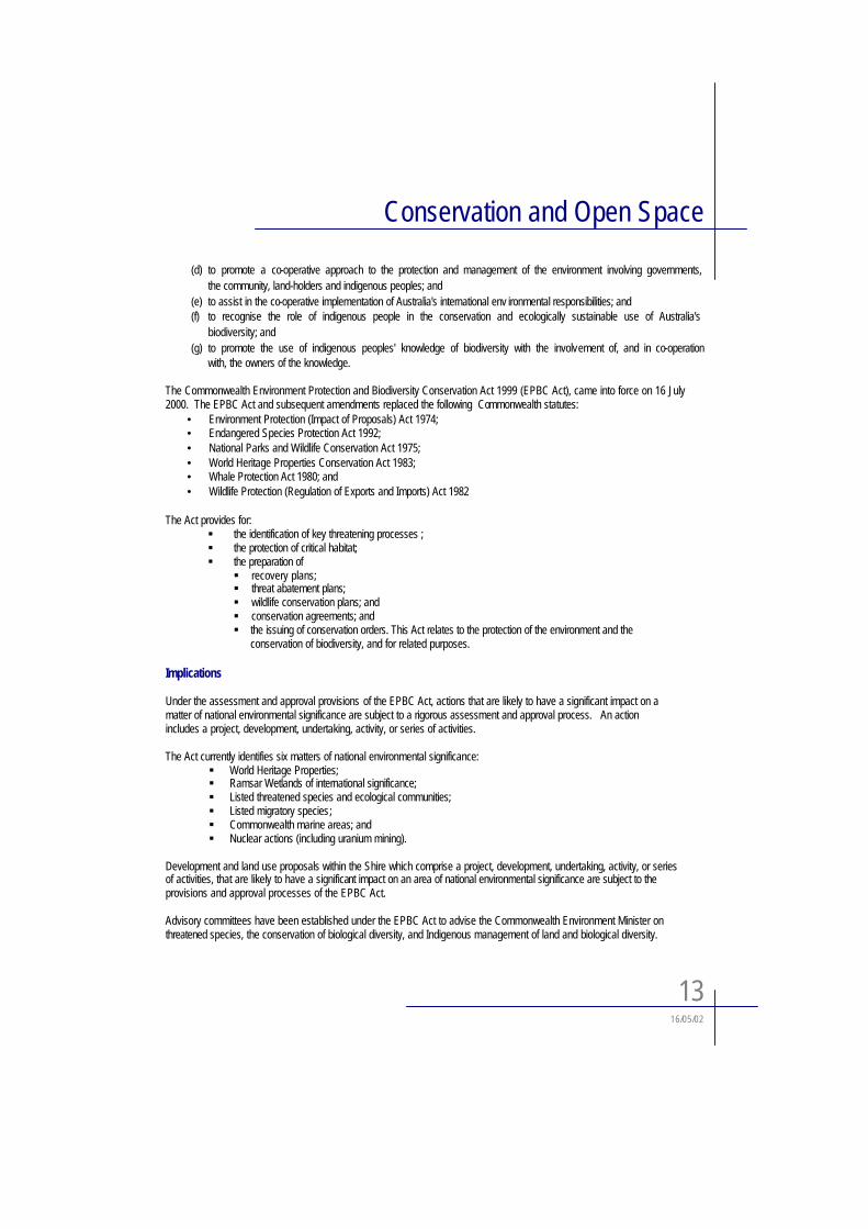
(d) to promote a co-operative approach to the protection and management of the environment involving governments, the community, land-holders and indigenous peoples; and
(e) to assist in the co-operative implementation of Australia's international env ironmental responsibilities; and (f) to recognise the role of indigenous people in the conservation and ecologically sustainable use of Australia's
biodiversity; and (g) to promote the use of indigenous peoples' knowledge of biodiversity with the involvement of, and in co-operation
with, the owners of the knowledge.
The Commonwealth Environment Protection and Biodiversity Conservation Act 1999 (EPBC Act), came into force on 16 July 2000. The EPBC Act and subsequent amendments replaced the following Commonwealth statutes:
• Environment Protection (Impact of Proposals) Act 1974; • Endangered Species Protection Act 1992; • National Parks and Wildlife Conservation Act 1975; • World Heritage Properties Conservation Act 1983; • Whale Protection Act 1980; and • Wildlife Protection (Regulation of Exports and Imports) Act 1982
The Act provides for: ! the identification of key threatening processes ; ! the protection of critical habitat; ! the preparation of
! recovery plans; ! threat abatement plans; ! wildlife conservation plans; and ! conservation agreements; and ! the issuing of conservation orders. This Act relates to the protection of the environment and the
conservation of biodiversity, and for related purposes.
Implications
Under the assessment and approval provisions of the EPBC Act, actions that are likely to have a significant impact on a matter of national environmental significance are subject to a rigorous assessment and approval process. An action includes a project, development, undertaking, activity, or series of activities.
The Act currently identifies six matters of national environmental significance: ! World Heritage Properties; ! Ramsar Wetlands of international significance; ! Listed threatened species and ecological communities; ! Listed migratory species;! Commonwealth marine areas; and ! Nuclear actions (including uranium mining).
Development and land use proposals within the Shire which comprise a project, development, undertaking, activity, or series of activities, that are likely to have a significant impact on an area of national environmental significance are subject to the provisions and approval processes of the EPBC Act.
Advisory committees have been established under the EPBC Act to advise the Commonwealth Environment Minister on threatened species, the conservation of biological diversity, and Indigenous management of land and biological diversity.

Conservation and Open Space
1416/05/02
3.1.2 Nature Conservation Act 1992
Purpose
The Nature Conservation Act is based on principles to conserve biological diversity, ecologically sustainable use of wildlife, ecologically sustainable development and international criteria developed by the World Conservation Union (International Union for the Conservation of Nature and Natural Resources) for establishing and managing protected areas.
The Act’s objective is the conservation of nature. This to be achieved by an integrated and comprehensive conservation strategy for the whole of Queensland addressing the following matters:
- Gathering researching and disseminating information on nature, identifying critical habitats and areas of major interest, and encouraging the conservation of nature by education and co-operative involvement of the community;
- Dedication and declaration of areas representative of the biological diversity, natural features and wildernessof Queensland as protected areas;
- Managing protected areas;- Protecting native wildlife and its habitat;- Ecologically sustainable use of protected wildlife and areas;- Recognition of the interests of Aborigines and Torres Straight Islanders in nature and their co-operative
involvement in its conservation; and- Co-operative involvement of landholders.
Planning ImplicationThe implications of the Act to land use and development within Redland Shire principally relate to the management of protected areas, practices and policies which seek to maintain biodiversity, and wildlife and vegetation management.
3.1.3 Coastal Protection and Management Act 1995
PurposeThe purpose of the Coastal Protection and Management Act is to:
- Provide for the protection, conservation, rehabilitation and management of the coast including its resources and biological diversity;
- Have regard to the goal, core objectives and guiding principals of the national strategy for ecologically sustainable development in the use of the coastal zone;
- Provide with other legislation a coordinated and integrated management and administrative framework for the ecologically sustainable development of the coastal zone; and the framework is something
- Encourage the enhancement of knowledge of coastal resources and the effect of human activities on the coastal zone.
The Act requires the Minister to prepare a state coastal management plan. This plan is titled “State Coastal Management Plan – Queensland’s Coastal Policy”. The plan describes how the region is to be managed and identifies control districts to affect such management.
Planning Implication
The Redland Shire is affected by the provisions of the CPM Act, and accordingly planning strategies and settlement patterns need to acknowledge and be cognisant of the requirements of the CPM Act. Maximising the retention of foreshore areas in a non-urban and publicly accessible state is a key component of policy approaches endorsed under the CPM Act.
Conservation and Open Space
1516/05/02
In December 2001, the Queensland Parliament passed amendments to the Coastal Protection and Management Act 1995 (Coastal Act), making the assessment of all coastal development subject to the requirements of the Act, with the assessment process to be handled under the Integrated Planning Act. The amendments are expected to commence in mid 2002 at which time the EPA will have additional concurrence and referral roles in yet to be defined coastal areas.
3.1.4 Marine Parks Act 1982
PurposeThe aim of the Marine Parks Act 1982 is to provide for the setting apart of tidal lands and tidal waters as marine park and for related purposes.
The functions of the chief executive under the Act are to;
- Assess the suitability of tidal lands and tidal waters for setting apart and declaring as marine parks;- Recommend areas that should be set apart and declared;- Ensure Marine parks that have been set apart and declared are managed and controlled accordingly;- Provide regulations that should be made;- Define areas of interest;- Give public notice and receiving submissions about proposals, and revocation procedures;- Prepare a zone plan in respect of each area set apart and declared as a marine park;- Undertaking of works and delegations;- Establish general offences;- List matters for regulations.
Planning ImplicationThe relevance of the Marine Park Act lies principally in its role as the parent legislation under which the Moreton Bay Marine Park was proclaimed.
3.1.5 Marine Parks (Moreton Bay) Zoning Plan 1997
Purpose
The Moreton Bay Marine Park was proclaimed in February 1993 under the Marine Park Act, 1982. The Marine Park provides the mechanism for the State Government to implement the policies of the Moreton Bay Strategic Plan. The Zoning Plan was formally adopted by the State Government in 1997.
Planning Implication
This provides for five zones and six designated areas to provide a balance between human needs and the needs to conserve Moreton Bay’s special values. Implications of the plan are discussed in greater detail in Section 3.6.4 of this report.
3.1.6 Integrated Planning Act 1997
Purpose
The purpose of the Integrated Planning Act 1997 is to achieve ecological sustainability by achieving a balance between ecological, economic and social outcomes. The purpose of the Act requires the achievement of “ecological sustainability” in a manner that includes ensuring that decision-making processes provide for equity between present and future generations.
Conservation and Open Space
1616/05/02
Conservation therefore has distinct relevance to the purpose of the Act and advancing that purpose.
The Integrated Planning Act 1990 also stipulates in section 2.1.3 that a planning scheme must amongst other things, co-ordinate and integrate the matters (including the core matters) dealt with by the planning scheme, including any State and regional dimensions of the matters 2
Core matters for the preparation of a planning scheme are set out in Schedule 1 of the Act and include:(a) land use and development;(b) infrastructure; and(c) valuable features.
Valuable features relate strongly to conservation and are defined as including the following:
(a) resources or areas that are of ecological significance (such as habitats, wildlife corridors, buffer zones, places supporting biological diversity or resilience, and features contributing to the quality of air, water (including catchments or recharge areas) and soil);
(b) areas contributing significantly to amenity (such as areas of high scenic value, physical features that form significant visual backdrops or that frame or define places or localities, and attractive built environments);
Planning ImplicationThis paper is one of the mechanisms by which valuable features are to be addressed in the planning scheme preparation process.
3.1.7 State Planning Policy 1/97 (Conservation of Koalas in the Koala Coast)
PurposeState Planning Policy 1/97 addresses planning issues related to the conservation of Koalas and their habitat in the Koala coast.
Planning ImplicationState Planning Policy 1/97 addresses the conservation of Koalas and their habitat in the Koala Coast area. Both State and Local Governments and the Planning and Environment Court are required to have due regard to the provisions of the policy in exercising their planning and land use management functions.
The provisions of the policy provide comprise a significant constraint to future development of urban and semi urban nature particularly within areas of the Shire, which have to date, remained in a rural and/or natural state. The policy addresses threats to the koala population, development and land use within the koala coast area, and the role of planning schemes in implementing appropriate management controls.
2 refer section 2.1.3 of the Integrated Planning Act.
Conservation and Open Space
1716/05/02
3.1.8 Vegetation Management Act 1999
PurposeThe purposes of this Act are to regulate the clearing of vegetation on freehold land to—
(a) preserve the following—(i) remnant endangered regional ecosystems;(ii) vegetation in areas of high nature conservation value and areas vulnerable to land degradation; and
(b) ensure that the clearing does not cause land degradation; and(c) maintain or increase biodiversity; and(d) maintain ecological processes; and(e) allow for ecologically sustainable land use.
Planning Implication The key implication of the Vegetation Management Act is that vegetation clearing on private land is defined as operational works and comprises assessable development under the IPA. Applications for development approval for operational works (vegetation clearing) are subject to referral to the designated assessment manager being the Department of Natural Resources and Mines.
3.1.9 Fisheries Act 1994
PurposeAn Act for the management, use, development and protection of fisheries resources and fish habitats and the management of aquaculture activities and for related purposes. The objectives of this Act include—
1. Ensuring fisheries resources are used in an ecologically sustainable way; and2. Achieving the optimum community, economic and other benefits obtainable from fisheries resources; and3. Ensuring access to fisheries resources is fair.
The objectives are to be achieved mainly by —(a) Establishing the Queensland Fisheries Policy Council as a representative body to advise on strategic policy
issues affecting fisheries resources and fish habitats; and(b) Establishing the Queensland Fisheries Management Authority to manage and protect fisheries resources with
the chief executive of the department; and(c) Giving appropriate powers to enable the Authority and chief executive to perform their respective functions; and(d) Providing for the management and protection of fish habitats; and(e) Providing for the management of commercial, recreational and indigenous fishing; and(f) Providing for the prevention, control and eradication of disease in fish; and(g) Providing for the management of aquaculture.
Planning ImplicationRedland Shire includes a significant area of coastline both on the mainland and Moreton Bay Islands. Development on or adjacent to the coast needs to be cognisant of the potential impacts on the receiving waters of Moreton Bay. Land use proposals located in close proximity to the Coast need to take cognisance of the effect of zoning provisions for Moreton Bay to ensure an appropriate level of compatibility is obtained. Development resulting in the removal of marine plants also requires relevant approvals pursuant to the Fisheries Act.
Conservation and Open Space
1816/05/02
3.2 Nature Conservation within Redland Shire
3.2.1 Areas of Conservation Value
The Environmental Protection Agencies ‘Guidelines for Protection of Regional Landscape Values’ defines areas of nature conservation value as:
“areas of land or water that, as assessed by the Regional Nature Conservation Strategy for South East Queensland, contribute significantly to the biodiversity of nature, the viability of biotic communities and the functioning of natural ecosystems.
Land within nature conservation value includes areas that contain native wildlife (flora and fauna) and landforms associated with different wildlife communities. Specifically, such areas include habitat and movement corridors for wildlife; areas required for ecological and other scientific purposes; and major landforms (e.g. rivers, streams, bays, remnant vegetation/bushland, estuaries, wetlands, coastlines, lakeshores, valleys, hills and subterranean features such as lava tubes and caves.”
The identification and analysis of Redland Shire’s underlying conservation values has been undertaken through thepreparation of the Redland Shire Environmental Inventory.
3.3 Environmental Inventory
3.3.1 Background
In January 1995, Redland Shire Council commissioned Chenoweth and Associates Pty Ltd in association with EDAW(Australia) to undertake Stage 1 of a two stage Environmental Inventory as part of Council’s Habitat Protection Strategy.
The Stage 1 Redland Environmental Inventory Draft Report (6 March 1996) provides mapping of the Shire’s habitats and their ecological function, an information base of the known flora and fauna within these habitats, and some direction as to priorities for future research. Stage 2 of the Redland Environmental Inventory has commenced and consists of periodic updating of the environmental information and mapping based on more accurate information about habitats and wildlife, and on continuing application and refinement of the Stage 1 methodology.
The identification of significant resources and other values in of the Redland Environmental Inventory is an key initial step in achieving environmentally responsive planning. It is equally import however that appropriate strategic and land usemechanisms are used to protect such values following identification. The Redland Environmental Inventory provides aframework for Council and community decision making based on a clear appreciation of these environmental values, constraints and opportunities. The inventory provides a comprehensive analysis of the combined conservation values and significance of specific areas within the Shire. Accordingly it provides a sound basis for land use planning andmanagement.
A summary of the key findings of the Stage 1 Environmental Inventory Report is presented below.
3.3.2 Environmental Overview
The Shire’s significant environmental attributes may be summarised as follows;
• Regional Context
Conservation and Open Space
1916/05/02
Large areas of Redland Shire have been identified in planning strategies for South East Queensland as containingbushland habitat of regional significance. These areas have been identified as representing a major recreational andenvironmental resource, important for vegetation, fauna, water supply and recreation within Redland Shire and South East Queensland.
• GeologyThe geology of Redland Shire has resulted from volcanic activity, uplifting, faulting and depositing through ancientalluvial processes and stream activity. The rich agricultural soils of the region have been formed from the weathering of the balsatic flows of the Lamington Group.
Moreton Bay forms a back barrier lagoon system with a network of channels and deltaic islands. The inner Bay Islands were once part of the mainland before glacial melting resulted in the current ‘drowned’ landscape. Peel Island is underlain by areas of living coral, North Stradbroke Island consists largely of dunes and the coastal perimeter features significant environmental and hydrological resources, particularly Eighteen Mile Swamp.
• HydrologyThe major watercourses which influence the hydrology of Redland Shire (Logan River and Coolnwynpin, Tingalpa, Hilliards and Eprapah Creeks) support a diverse ecosystem of aquatic and riverine flora and fauna, freshwaterwetlands and swamps. The tidal and estuarine wetland which fringe the watercourses form the foundation of thedelicate coastal and mangrove ecosystems.
Leslie Harrison Dam and Eighteen Mile Swamp provide a significant ecological function on a regional level as a water bird and aquatic fauna habitat; Eighteen Mile Swamp in particular supports a diverse range of unique vegetationspecies not commonly found in South East Queensland.
• VegetationOut of fifteen local authorities surveyed in the South East Queensland region, Redland Shire was identified as having the largest land area which remains vegetated with approximately 56% occupied by remnant bushland. The bushland in the South East Queensland region is becoming increasingly fragmented, largely as a result of high rates ofpopulation growth, and resulting urbanisation.
The vegetation of Redland Shire may be broadly characterised as:
- Closed Forest: Incorporates rainforests, riparian forests, vine forest and palm forest, the latter being represented along Tingalpa, Buhot and Eprapah Creeks;
- Eucalypt Open Forest and Woodlands: These are the most widespread naturally occurring plant communities in the Shire, typically found on hillslopes and in the vicinity of Mount Cotton;
- Melaleuca Open Forests and Woodlands: Occur in areas with poor drainage, usually along creek lines and along the coastal lowland of the Shire, as well as in the Black Swamp and at Sunny Bay Drive;
- Heathland: These represent diverse communities of shrubs which tend to occur in a mosaic with open forest and woodland communities;
- Mangroves and Other Littoral Communities: Dominated in the region by grey mangrove with two extensive stands of littoral communities located at Geoff Skinner Reserve and Point Halloran, and also found on many of thesmaller low lying bay islands.
The distribution of vegetation types is illustrated on Figure 3.3.1.

Conservation and Open Space
20 16/05/02
• FaunaThe following provides a general indication of the diversity of fauna within Redland Shire:
- Koalas: One of the most significant faunal species in Redland Shire, mainly found at Mt Cotton, Sheldon, Thornlands and along creek corridors. The size and viability of the Koala population have resulted I it being acknowledged as nationally significant;
- Other Mammals: Eastern Grey Kangaroo, wallabies, gliders, possums, echidnas, rodent species, bandicoots, flying foxes, and the common Benturing Bat are found throughout the Shire, with the vulnerable Dugong and Humpback Whales, Sperm Whale, Spinner Dolphin and Bottle-Nosed Dolphin found in the sheltered waters of Moreton Bay;
- Birds: The Shire has a large diversity of bird species as a result of the variety and availability of habitat areas, particularly a number of wetland areas which have been identified as RAMSAR sites significant for migratory wading birds. A number of rare and significant bird species have been recorded;
- Reptiles: A range of reptiles have been recorded including vulnerable and endangered species;
- Frogs, Freshwater Fish and Insects: A number of different species has been recorded including one of the rarest butterflies in Australia.
3.3.3 Inventory Framework and Composition
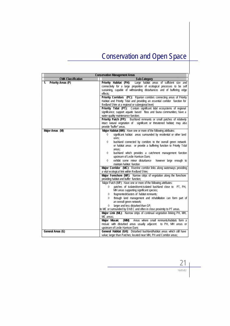
For the purpose of the Inventory and its findings, the Shire has been categorised and mapped into various Conservation Management Areas (CMAs) according to the relative significance of areas for conservation management purposes. Four broad categories of CMA (Priority, Major, General, Enhancement) have been devised. These have been further subdivided into type classifications including Habitat, Patch, Mosaic, Corridors, Links, Tidal, and Foreshore. The CMA locational codes are comprised of an Alphabetical Code (described below) and a numeric code which indicates the location of the areaconcerned.
The mapping provided as part of the Stage 1 Redland Environmental Inventory Draft Report was amended as part of Stage 2 of the Redland Environmental Inventory. The amendments were based on more accurate information on significanthabitats and wildlife, and on continuing application and refinement of the Stage 1 methodology.
The Stage 2 mapping is used as a basis for the Strategic Plan Preferred Dominant Land Use Map and Greenspace Map.
The overall characteristics of the principal CMA classifications are as follows:
Conservation and Open Space
2116/05/02
Conservation Management AreasCMA Classification Sub-Category
Priority Habitat (PH): Large habitat areas of sufficient size andconnectivity for a large proportion of ecological processes to be selfsustaining, capable of withstanding disturbances and of buffering edgeeffects;Priority Corridors (PC): Riparian corridors connecting areas of PriorityHabitat and Priority Tidal and providing an essential corridor function for Redland Shire at a regional or subregional level;Priority Tidal (PT): Contain significant tidal ecosystems of regional significance; support aquatic based flora and fauna communities; have awater quality maintenance function;
1. Priority Areas (P)
Priority Patch (PP): Bushland remnants or small patches of relatively intact natural vegetation of significant or threatened habitat; may alsoprovide “buffer” areas.Major Habitat (MH): Have one or more of the following attributes:
◊ significant habitat areas surrounded by residential or other land uses;
◊ bushland connected by corridors to the overall green network or habitat areas or provide a buffering function to Priority Tidalareas;
◊ bushland which provides a catchment management functionupstream of Leslie Harrison Dam;
◊ exhibit some minor disturbance however large enough tomaintain habitat function
Major Corridor (MC): Riverine corridor links along waterways providinga vital ecological link within Redland Shire;Major Foreshore (MF): Narrow strips of vegetation along the foreshore providing habitat and buffer function;Major Patch (MP): Have one or more of the following attributes:
◊ patches of isolated/semi-isolated bushland close to PT, PH, MH areas supporting significant species;
◊ fragmented/clusters of habitat remnants;◊ through land management and rehabilitation can form part of
an overall green network;◊ larger and less disturbed than GP;
to MC or surrounded by EH/EC and often in close proximity to PT areas.Major Link (ML): Narrow strips of continual vegetation linking PH, MH, MC areas;
Major Areas (M)
Major Mosaic (MM): Areas where small remnants/habitats form amosaic with disturbed areas usually adjacent to PH, MH areas orupstream of Leslie Harrison Dam;
General Areas (G) General Habitat (GH): Disturbed bushland/habitat areas which still have value; larger than Patches; located near MH, PH and Corridor areas;
Conservation and Open Space
2216/05/02
Conservation Management AreasCMA Classification Sub-Category
General Corridor (GC): Have one or more of the following attributes:◊ narrow, disturbed, fragmented native riparian vegetation along
waterways;◊ vital linkage function;◊ small coastal and significant minor tributaries off MCs.
General Patch (GP): Have one or more of the following attributes:◊ scattered bushland with local habitat and amenity value;◊ fragmented bushland with a habitat function;◊ poor connectivity with other areas, however, may be near MH
and MP areas;◊ have greater disturbance than MPs;
General Links (GL): Small narrow vegetated links adjoining localised and/or isolated patches of bushland to other Major/General bushlandtracts/corridors.Enhancement Habitat (EH): Cleared or degraded areas near bushland areas of environmental significance representing opportunities forrehabilitation, habitat extensions, buffers and/or links.Enhancement Corridors (EC): Exhibit the following:
◊ opportunities for revegetating a creek/waterway/drainage line toextend an existing corridor to link Habitat and Patch areas;
◊ substantially cleared or degraded;◊ opportunity for potential expansion or widening of existing
corridors;◊ located along main and significant minor tributaries.
Enhancement Foreshore (EF): Cleared or disturbed areas adjacent to foreshores with potential to be rehabilitated to enhance and protect thecoastal ecosystem particularly tidal wetland areas.
Enhancement Areas (E)
Enhancement Link (EL): cleared or degraded areas representingopportunities for revegetation to link Habitat and Patch areas.(These differ from Enhancement Corridors in that they do not run along creeks/waterways/drainage lines.)
Planning Implications
Information mapped and presented within the Conservation Management Areas format can be used as a ‘Green Base’ for land use planning. This includes setting the broad framework for areas of conservation significance to be retained within the strategic planning process as well as highlighting environmental and conservation issues to be addressed in the futuredevelopment of individual land parcels. Although these mapped units convey a definite hierarchy of conservationsignificance and development constraint, they are also somewhat adaptable and flexible.
Priority areas (P) will be the most restrictive category and oriented towards environmental conservation.
Priority Habitat areas (PH) are generally large and continuous, represent important regional bushland areas and areintended to define areas which should remain relatively undisturbed if their habitat values are to be retained. Priority Corridors (PC) may include disturbed land and canopy breaks in conjunction with preserved bushland and riparian zones, which may need to be rehabilitated to maintain the corridor function.
Conservation and Open Space
2316/05/02
Priority Tidal areas (PT) are coastal and estuarine areas that contain natural marine ecosystems such as saltmarsh and mangroves. Isolated clearing within Priority Habitat areas have been designated as Enhancement Habitat (EH) where their strategic location and potential susceptibility to weeds and domestic animals indicate that strict environmental standards and rehabilitation should be implemented where possible. Priority Patches (PP) are isolated areas of bushland located within or adjacent to Priority Tidal (PT) units which provide a valuable ecological function to the coastal ecosystem.
Within Major areas, the conservation of natural values also comprises a primary consideration and any development and/or land use must be ecologically sustainable and ensure conservation values are not compromised. Major Habitat areas (MH) are continuous tracts of bushland that may include some disturbance but will provide viable habitat for a range of plants and animals and which buffer, surround and extend Priority habitat areas. Some Major Habitat areas (MH) are pockets of habitat linked to Priority Corridors which primarily function as temporary refuges, breeding and restocking areas for wildlife. Major Patches (MP) are isolated or semi-isolated remnants which still retain integrity and habitat value.
Major Corridors (MC) have been defined along creeks and drainage lines likely to function as faunal movement routes.Major Links (ML) are usually shorter in length, not necessarily along drainage routes and may join fragmented bushland.
Areas designated as Major Foreshore (MF) consist of narrow strips of vegetation along the foreshore regions of the Shire.They often correspond to coastal wetlands and other coastal regions.Major Mosaic areas (MM) include strategically located but fragmented bushland where development should be aimed to retain or enhance existing ecological values wherepossible.
Vegetation and habitat which has been significantly disturbed or fragmented have been classified as General. Within these areas, detailed planning and design should consider habitat values, ecological values and other localised areas ofsignificance, but generally there are opportunities for sensitive development. As with the other categories, General Habitat (GH), General Patches (GP), General Corridors (GC), General Links (GL) and General Mosaic (GM) describe the main values and functions of these areas. However, these units are generally on a smaller scale and corridors tend to benarrower.
Cleared areas with strategic potential which represent opportunities for rehabilitation and ecologically sustainabledevelopment have been mapped as Enhancement CMAs. Enhancement Habitat (EH) areas are classified as those areas which consist of cleared or highly disturbed land with varying land uses where opportunities exist for revegetation andrehabilitation to extend present habitats. Enhancement Corridors (EC) are areas situated along the waterways or drainage lines which have previously been cleared but have the potential to link areas of habitat. Enhancement Links (EL) are usually shorter in length, not situated along waterways and may provide a future potential to join fragmented bushland.
3.3.4 Inventory Application Under Current Land Use Framework
The environmental characteristics identified in the Environmental Inventory are considered to be of significance andaccordingly are given due recognition under the existing Strategic Plan. To this end all the Conservation ManagementAreas (CMAs) in the Environmental Inventory are shown on the Greenspace Map as a single Greenspace layer. Land uses occurring within areas denoted as having environmental significance on the Greenspace Map are required to have dueregard to the particular characteristics described in the Environmental Inventory affecting these areas. These characteristics are described in detail in the Stage 1 Redland Environmental Inventory.
CMA’s which the Environmental Inventory identified in the waters of Moreton Bay lie outside of the jurisdiction of thePlanning Scheme. Notwithstanding this, it was considered important to include these onto the Greenspace to reflect the relationship between terrestrial land use and the quality of the marine environment particularly in respect of possible impacts on aquatic ecosystems from inappropriate stormwater quality management.
Conservation and Open Space
2416/05/02
Inclusion of Environmental Inventory components under the current Strategic Plan
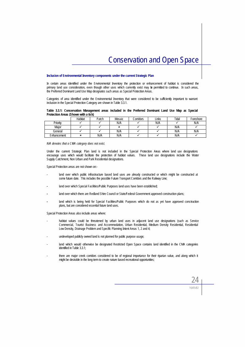
In certain areas identified under the Environmental Inventory the protection or enhancement of habitat is considered theprimary land use consideration, even though other uses which currently exist may be permitted to continue. In such areas, the Preferred Dominant Land Use Map designates such areas as Special Protection Areas.
Categories of area identified under the Environmental Inventory that were considered to be sufficiently important to warrantinclusion in the Special Protection Category are shown in Table 3.3.1.
Table 3.3.1: Conservation Management areas included in the Preferred Dominant Land Use Map as Special Protection Areas (Shown with a tick)
Habitat Patch Mosaic Corridors Links Tidal ForeshorePriority " " N/A " N/A " N/AMajor " " # " " N/A "
General " " N/A " " N/A N/AEnhancement # N/A N/A " " N/A "
N/A denotes that a CMA category does not exist.
Under the current Strategic Plan land is not included in the Special Protection Areas where land use designations encourage uses which would facilitate the protection of habitat values. These land use designations include the WaterSupply Catchment, Non Urban and Park Residential designations.
Special Protection areas are not shown on:-
- land over which public infrastructure based land uses are already constructed or which might be constructed at some future date. This includes the possible Future Transport Corridors and the Railway Line;
- land over which Special Facilities/Public Purposes land uses have been established;
- land over which there are Redland Shire Council or State/Federal Government approved construction plans;
- land which is being held for Special Facilities/Public Purposes which do not as yet have approved constructionplans, but are considered essential future land uses.
Special Protection Areas also include areas where:
- habitat values could be threatened by urban land uses in adjacent land use designations (such as ServiceCommercial, Tourist Business and Accommodation, Urban Residential, Medium Density Residential, Residential Low Density, Drainage Problem and Specific Planning Intent Areas 1, 2 and 4;
- undeveloped publicly owned land is not planned for public purpose usage;
- land which would otherwise be designated Restricted Open Space contains land identified in the CMA categories identified in Table 3.3.1;
- there are major creek corridors considered to be of regional importance for their riparian value, and along which it might be desirable in the long term to create nature based recreational opportunities;
Conservation and Open Space
2516/05/02
- allotments are operated by community based organisations and have some form of fauna or flora sanctuary status or are subject to voluntary conservation agreements;
- the CMA designations shown in Table 3.3.1 are identified for environmental protection and enhancement inrelation to nearby urban land use designations within the Major Business Centre designations.
3.3.5 Review of Inventory Application
A review of the application of the existing Greenspace system has identified the following limitations and weaknesses:
! Greenspace mapping has contributed to inaccurate perceptions concerning the conservation status of certain areas, with only some greenspace elements being supported by compatible preferred dominant land use designations under the current strategic plan;
! Certain Greenspace areas have been developed due to inconsistent underlying zoning; and! The absence of complementary land use controls and development standards to support the strategic
greenspace policies has limited Council’s ability to protect environmental values in those Greenspace areas not designated as Special Protection and or Restricted Open Space.
The current approach to Greenspace and Special Protection Areas is fragmented and confusing and misunderstood by the community. The review of Greenspace system has highlighted the need for the approach to nature conservation under theIPA Planning Scheme to be cognisant of the following:
! The need to move away from a compartmentalised approach to Greenspace mapping which is characterised by the separate identification of Greenspace elements and preferred land use outcomes;
! The need for greater specificity in the designation of areas subject to varying levels of environmental/conservation constraint. This may for example result in different designations being allocated to environmental areas having core, non-core and linkage functions.
! The need to ensure environmental values in areas designated for non- conservation purposes are recognisedand addressed in the development assessment process through the preparation and application of appropriate environmental codes;
3.4 Vegetation Management
3.4.1 Remnant Vegetation Mapping and Assessment
A remnant vegetation mapping and assessment study was recently undertaken by Landscape Assessment, Management and Rehabilitation Pty Ltd which was part of a larger project aimed at also characterising the non-remnant and pre-clearingextent of the vegetation mosaic. The report details the most significant components of the remnant vegetation mosaic within Redland Shire.
It is essential to gain an adequate appreciation of the natural resources within Shire’s vegetated areas in order to protect and enhance those values that the community and Redland Shire Council deem to be important for the present and future environmental integrity of the Shire. The aim of the mapping and assessment project was to adequately document remnant vegetation so that its values may be incorporated into a land management and conservation decision-making process. This process is expected to play a role in determining preferred management approaches to varying areas of remnant natural vegetation.
Conservation and Open Space
2616/05/02
Despite important caveats and constraints on this and other vegetation mapping exercises, the products provide useful land management tools for landholders, statutory authorities and other stakeholders. Specifically, it is possible to gauge theextent, location and frequency of the defined vegetation units. This provides a basis for comparison with past records of vegetation distribution to assess clearing rates for the respective vegetation units and to determine the rarity of remainingcommunities, some of which have been designated as containing rare and threatened species.
Within the context of the IPA Planning Scheme, areas identified in this study as containing vegetation units of high ormoderate significance need to be recognised and protected under compatible land use designations.
3.5 Koala Management
3.5.1 BackgroundThe Redland Shire contains a highly significant and viable Koala population of both regional and national significance.
There are two primary mechanisms which seek to secure the protection of the Koala population within the Shire, these are:! Koala Bushland Coordinated Conservation Area; and! State Planning Policy 1/97 – Conservation in the Koala Coast
3.5.2 Koala Bushland Coordinated Conservation AreaThe Koala Bushland Coordinated Conservation Area consists of 1170 hectares of remnant bushland within Logan andRedland Shires. The primary aim of the area is to protect koalas and their habitat, to protect stream flora and faunacommunities, and protect bushland catchments. It is a formal long-term means for landholders to coordinate management of their properties. The coordinated conservation area contains:
• Daisy Hill State Forest,• Venman Bushland National Park,• Ford Road Conservation Area and • Road Reserves
Participating landholders include:• Department of Natural Resources• Queensland Parks and Wildlife Service• Logan City Council; and• Redland Shire Council
All landholders have entered into voluntary agreement to use the land under their control for conservation purposes, while maintaining their own particular interests. The coordinated conservation area is protected under the Nature Conservation Act 1992, which specifies principles for management. Regulations also apply which control activities within this area.
3.5.3 State Planning Policy 1/97 - Conservation of Koalas in the Koala CoastState Planning Policy 1/97 has been prepared recognising and addressing issues relating to the conservation of koalas within the Koala Coast. Relevant extracts from this policy are outlined in this section of the report. A major proportion of the Koala Coast is situated within Redland Shire.
The Koala Coast as defined by the Policy includes large and extensive areas of relatively unfragmented habitat whichcontaining large numbers of koalas at unusually high density. The Koala Coast has a number of characteristics which make it one of the most significant koala habitats in Australia. These characteristics include:
Conservation and Open Space
27 16/05/02
• the existing large koala population;• extensive area of habitat;• high density of food and shelter trees; and• relative lack of habitat disturbance.
The Policy also refers to koala habitat values. Koala habitat values are all those characteristics of an area that make it suitable as habitat or refuge for koalas, including the nature, extent and condition of habitat and location of the site inrelation to other areas of habitat.
The area, therefore, presents a unique and very important opportunity to conserve a large component of the regional koala population. The Koala Coast has also been identified as having broader nature conservation values including biologically significant areas such as rainforests and wetlands. These areas support some rare and endangered flora and faunal species. Conservation within the Koala Coast, whilst specifically aimed at the protection of koalas will also achieve broader nature conservation objectives.
Threats to KoalasThe demands for urban expansion and other forms of development (including rural residential) are threatening the extentand quality of the remaining habitat. The main threat to the long term survival of the koala is therefore the loss and/orfragmentation of habitat through urban development as well as from clearing of vegetation for agriculture and otheractivities. Traffic and domestic dogs also threaten koala numbers.
Conservation DesignationsThe State Planning Policy establishes three broad geographic designations: the Koala Conservation Area, Other MajorHabitat and the Koala Coast Balance Area (delineated on Figure 2.1.1). Characteristics and objectives of these areas are as follows:
• Koala Conservation Area - a significant planning objective is the conservation of koalas and their habitats in ways that do not affect existing
uses and development rights or remove development commitments ;- designates a large integrated and relatively undisturbed area which allows koalas to move and disperse for
breeding, social behaviour and feeding purposes, thereby allowing koala sub-populations to interact, which is necessary to maintain genetic diversity and the population’s long-term sustainability ;
- generally comprises areas of intact or partly cleared bushland with intrinsic koala habitat values, plus some areas cleared of vegetation which overall provides a highly favourable habitat for koalas;
• Other Major Habitat - with two exceptions, the general characteristics and intent of this designation are identical to those for the Koala
Conservation Area;- the first exception is that most of the Other Major Habitat does not form part of a single cohesive area;- the second exception is that the precise alignment of Other Major Habitat designation boundaries can be
amended by local governments, either in their planning schemes or through development assessment.
• Koala Coast Balance Area- comprises all land in the Koala Coast not included in either of the above designations;- includes land under a variety of different land uses and land which will be subject to a variety of different land uses
and developments in the future;- significant koala habitat should be conserved wherever practicable in the Koala Coast Balance Area.
Conservation and Open Space
2816/05/02
3.5.4 Planning Implications
Development and Land Use in the Koala Coast
Development anywhere in the Koala Coast should, as far as practicable, minimise adverse impacts on koala habitat values.In particular, in the Koala Conservation Area and Other Major Habitat, development must be compatible with theconservation of koala habitat values except in circumstances where:
• the development is a right or commitment provided for in the relevant Planning Scheme (ie. clearly designated in a Strategic Plan or Development Control Plan, a development not requiring a planning approval, a non-discretionarysubdivision provision or an existing development approval); or
• an overriding need for the development in terms of the public interest can be demonstrated and there is no other site suitable and reasonably available for the proposed purpose (proposal would need to demonstrate a significant overall net benefit to the community that outweighs environmental impacts).
The following criteria need to be met in order for a development proposal to be considered compatible with the conservation of koala habitat values:
• little or no clearing of vegetation would be required;• for sites in the Koala Conservation Area, minimal additional night-time traffic movements would be generated on the
road network in the Koala Conservation Area;• any impedance or threats to the movement of koalas through or across the site would be minimised;• there would be no other significant detrimental environmental impacts on the koala habitat values in the surrounding
area; and• koala habitat values would be substantially maintained or enhanced;
The Planning Guidelines Conservation of Koalas in the Koala Coast accompanying the Policy states in particular that low-density residential development (e.g. ‘park’ residential) does not meet the above criteria and would be inconsistent with the policy.
The Role of Planning Schemes
Planning Schemes are the principal instruments through which koala habitat values on private land will be protected from inappropriate land uses and development. Areas identified as having koala habitat value should therefore be regarded as being constrained to appropriate land uses.
Planning schemes are expected to incorporate the Koala Conservation Area and define and designate the boundaries of the Other Major Habitat.
The preferred pattern of land use in the Strategic Plan has been designed to minimise adverse impacts on koala habitat values. A strategy of consolidating growth within and adjacent to existing and committed urban areas, together withemphasising infill and higher density development is considered to have the least adverse impacts. New or amendedPlanning Schemes should not extend or intensify any existing development rights for developments which are incompatible with the conservation of koala habitat values in the Koala Conservation Area and Major Corridors.
Local governments should use a variety of approaches to minimise any potentially detrimental impacts of committeddevelopment on koala habitat values. These include negotiating with development proponents to achieve the bestpracticable outcomes for habitat protection, and using planning conditions attached to development approvals. Planningschemes could allow for ‘density bonuses’ to be offered over parts of a site to permit an equivalent or increased
Conservation and Open Space
29 16/05/02
development yield in return for conserving habitat areas on the remainder of the site. Alternative land uses that may be more compatible with conserving koala habitat values could also be encouraged.
Planning Schemes ought to include provisions showing the local authority to require planning applications for land in the koala coast to be accompanied by a koala habitat impact assessment where considered necessary.
The new planning scheme is obliged to recognise the development constraints imposed by this State Planning Policy and reflect these in any ensuing planning framework adopted for the Shire. The work undertaken as part of Council’sEnvironmental Inventory will assist in further defining areas of environmental significance within the designated MajorCorridor areas.
3.6 Coastal Issues
3.6.1 Legislative ContextThere are a number of pieces of legislation affecting land use within coastal areas of the Redland Shire, they are:
- Coastal Protection and Management Act 1995- Coastal Management Plan- Fisheries Act 1994- Moreton Bay Strategic Plan- Moreton Bay Zoning Plan
This Section of the report comments upon relevant parts of the Moreton Bay Strategic Plan and the Draft Zoning proposals of the Moreton Bay Marine Park which impinge on the coastal waters of Redland Shire. A brief comment is also made in respect of the Fisheries Act 1976-1989. Commentary on the provisions of the Coastal Management Protection Act has been included previously in Section 3.1.2 of this report.
3.6.2 Moreton Bay Strategic Plan OverviewThe Queensland State Government adopted the Moreton Bay Strategic Plan in February 1993 as a policy documentencompassing the Government's vision for management of Moreton Bay from Caloundra in the north to Southport in the south.Whilst not having statutory force, government departments and agencies are nevertheless required to observe the Plan's provisions. The Plan comprises a goal of ecologically sustainable use of the Bay supported by aims and objectives for planning and management decisions in respect of a range of preferred uses and levels of protection for Moreton Bay.
Management Categories of Strategic PlanThe Strategic Plan Map shows a range of management categories in term of preferred activities and locations, but these do not confer or imply use rights. The main categories of importance to Redland Shire are as follows:-
(i) General Use - The primary intent allows a wide range of uses which have minimal environmental impact. The area covers the major part of Moreton Bay from Raby Bay northwards to Caloundra. Raby Bay however is the only part of Redland Shire coastline which comes under this management category. The relevant secondary intent of this category, in respect of Raby Bay (and the new Cleveland Harbour) is to allow shipping, fishing, recreational, educational and research uses. The appropriate scale and nature of development is to be in balance with the local environment.
Conservation and Open Space
3016/05/02
(ii) Habitat Conservation - The primary intent is to identify important biological habitats. The area generally covers all of Moreton Bay south of Raby Bay, but includes coastal areas north of Raby Bay as well. Therefore, except for Raby Bay, the whole of the Redland Shire mainland coastal areas, all the Bay Islands, and Stradbroke Island are surrounded by this category.
The relevant secondary intents allow for commercial and recreational fishing, traditional Aboriginal fishing andhunting, recreational and research activities, which would not degrade the natural habitat areas and cultural heritage values.
(iii) Protection - The primary intent is to protect critical ecological communities and cultural heritage places and prevent or restrict incompatible uses. The area covers a large part of North Stradbroke Island (primarily the existing and proposed national and environmental parks, Eighteen Mile Swamp water reserve and Swan Bay Fish Sanctuary), Peel Island and a small part of the mainland east of Eprapah Creek.
The relevant secondary intents allow environmentally responsible non-extractive recreational, tourist,educational/interpretive and research based uses, which will not endanger significant biological communities and habitats or cultural heritage values and places.
(iv) Marinas and Harbours - The primary intent is for recreational boating, commercial water transport and associated on-shore facilities. The identified marinas and harbours in Redland Shire are the Raby Bay Boat Harbour, Cleveland Point; Toondah Harbour; Victoria Point jetty; Weinam Creek, Redland Bay; and One Mile Jetty, Dunwich. The Dunwich sands jetties and ferry terminal are included under the Ports and Industries Category, the only location in Redland Shire (This category primarily relates to the Port of Brisbane operations and sea lanes plus other water based industrial activities).
The Marinas and Harbours category does not cover Wellington Point jetty; Redland Bay jetty and Vehicular Ferry Terminal, north of Weinam Creek; or any of the Bay Islands jetties which are used by regular commercial boat transport.
The secondary intents are to provide for research and tourism, ancillary marine and terrestrial support facilities and infrastructure for the primary uses and to minimise impacts on valuable flora and fauna habitats and aquatic systems. This category primarily identifies existing marinas and boat harbour facilities and does not attempt to identify sites suitable for new facilities. As noted above, however, not all existing facilities in Redland Shire are covered.
(v) Island Village - The primary aim is for low density, low impact residential and ancillary development including low impact and limited tourist development. The areas in Redland Shire cover the five inhabited Bay Islands plus five localities on North Stradbroke Island (Dunwich, Amity Point (two areas), Flinders Beach, Point Lookout).
The secondary intents also include low key tourist accommodation; related commercial, day -visitor and essential urban support facilities.
3.6.3 Moreton Bay Marine Park and Zoning Plan
OverviewThe Moreton Bay Marine Park was proclaimed in February 1993 under the Marine Park Act, 1982. The Marine Park provides the mechanism for the State Government to implement the policies of the Moreton Bay Strategic Plan. The Zoning Plan was formally adopted by the State Government in 1997.
Conservation and Open Space
3116/05/02
Zoning ProvisionsThe Queensland Parks and Wildlife Service, with public input, has developed a zoning plan over the marine park, similar to a Planning Scheme over land. Moreton Bay Marine Park has five zones and six designated areas. They provide a balance between human needs and the need to conserve the Bay's special values.
Each zone has objectives defining activities that are allowed, those that require permits and those that are prohibited. Designated areas have special management requirements and are as important as the zones.
A description of the key zoning categories area provided as follows:
General use zones These provide areas for reasonable use and enjoyment of the marine park while allowing activities such as shipping operations. Much of the park is general use zone.
Habitat zones These provide areas for reasonable use and enjoyment while maintaining productivity of the natural communities by excluding activities such as shipping operations and mining.
Conservation zones These conserve the natural condition to the greatest possible extent and provide for recreational activities free from commercial trawling.
Buffer zone This area around Flinders Reef is very similar to a protection zone but allows trolling for pelagic fish.
Protection zones These are 'look but don’t take' areas of high conservation value. All forms of fishing and extracting are prohibited so people can enjoy the undisturbed nature of the area.
3.6.4 Fisheries Act 1976-1989
The Fisheries Act also has direct application to in Moreton Bay, particularly on development activities located on foreshore areas.The Fisheries Act protects mangrove areas and other related plant species in order to maintain the habitat of local and offshore fisheries. The Department of Primary Industries (DPI) Land Use and Fisheries Division administers the Act in respect of Applications for a Permit to remove Mangrove/Marine Plants. Therefore, any foreshore activity, including existing or proposed marinas, boat harbours and jetties which seek to remove mangrove/marine plants are required to obtain approval under Section 50 of the Fisheries Act..
Since the Moreton Bay Strategic Plan was adopted in 1993 and the Marine Park declared, DPI liaises closely with the Environmental Protection Agency (EPA) which administers the Marine Park. Both Departments now make combined decisions in respect of permits to remove mangrove/marine plants.
3.7 Wetlands and Waterways
3.7.1 Introduction
Redland Shire contains a number of catchments that drain a number of short coastal waterways into Moreton Bay or the Logan River. The largest waterways are Eprapah, Hilliards and Tingalpa Creeks. A number of tidal and estuarine wetlands fringe these waterways, in particular, Logan River, Tingalpa Creek and Hilliards Creek. These wetlands form the basis for the coastal and mangrove ecosystems.
The Shire also contains a number of ecologically significant wetlands including Black Swamp, Egret Colony, Tarradanapin Creek wetland and the extensive wetlands of North Stradbroke Island.
Conservation and Open Space
3216/05/02
Water quality in the Shire varies significantly in the Shire between waterways and between upper and lower reach locations.Historically the Shire was predominantly rural. However, the Shire has gone through, and continues to experience rapid urbanisation.
As part of this urbanisation process, water quality has received increasing prominence with both Council and the wider community.
3.7.2 Issues
There are a number of key issues that need to be addressed. These primarily have been described as existing water quality, raising the standards of stormwater treatment and the progressive improvement of receiving waterways throughout the Shire. It has been suggested that:
• Traditionally water quality control has not extended much beyond effluent treatment of municipal and industrial wastewater.
• Stormwater has commonly discharged directly into receiving waters and contributed to some waterways being significantly degraded.
Council is redressing a number of issues through both refinements to the development assessment processes and through the preparation of scientifically based studies. Separate studies are being undertaken for each of the major catchments in the Shire. Each of these studies includes a number of significant phases, including Scoping Study, Waterway Health Assessment and Community Consultation prior to the preparation of the Waterway Management Plan. It is intended that these catchment based studies provide the basis for land use decisions as well as a basis for establishing a range of other actions.
3.7.3 Principles
Key principles relevant to the preparation of the IPA Planning Scheme include the following:
• Healthy waterways are vital to the maintenance of biodiversity and to allow for a range of human activities.
• Inappropriate land uses and land use practices can have a dramatic impact on waterbodies – including the intentional discharge or accidental release of pollutants, increased sediment and nutrient loads, changes to runoff and erosion rates and infiltration rates to groundwaters – resulting in reduced productivity and diversity in waterways, estuaries and Moreton Bay.
• Catchment based planning supported by appropriate development standards will greatly assist in the identification of land use and land management issues and the identification of appropriate solutions
3.7.4 Planning Implications
From the preceding discussion on waterways and wetlands, the following implications for the Planning Scheme are drawn:
• Significant advances in the health of waterways and wetlands in the Shire can be achieved by reviewing land use patterns and development conditions and by acting on the outcomes of the waterway management plan beingprepared for the major catchments in the Shire.
• Irrespective of the process of waterway management plan preparation, the review of land uses needs to beundertaken on a catchment basis, in consultation with relevant Council officers and anticipating waterwaymanagement plan outcomes.
Conservation and Open Space
3316/05/02
• Waterways and wetlands form significant components of any Shire wide strategy to achieve biodiversity, including protection of adequate riparian corridors, revegetation of cleared corridors, restoration of wetland areas (whereclearing of low-lying land has occurred), weed management and monitoring supported by a network of reserves and habitats.
• Water quality controls and management include the need to set water quality standards for waterways and forwastewaters, appropriate provisions for on-site treatment, recycling and stormwater disposal
• Adoption of best practice and a focus on water sensitive urban design can provide innovative, quality outcomes
The proposed Planning Scheme for Redland Shire will need to:
• Aim to protect or enhance environmental values and valuable features of the Shire’s waterways and wetlands to ensure their ecological sustainability within a catchment context
• Incorporate in the Planning Scheme objectives to identify the environmental values and valuable features of the Shire’s waterways and wetlands within a catchment context and to protect the environmental values of the waterways and wetlands through setting agreed objectives and assessment provisions
In achieving this, the following provisions should be incorporated in the Planning Scheme:
• Catchment based provisions need to be included in the Planning Scheme covering the location and acceptableperformance criteria for on-site domestic waste treatment systems, having regard to the number of existing on-sitesystems in the locality, the potential cumulative effects on water quality, lot size, soil type, slopes, hydrology and hydro-geological characteristics, the proximity of surface and groundwater, rainfall and climatic conditions, existingwater quality and water quality objectives of the waterways.
• Environmental plans covering the extent of the urban strormwater systems and addressing urban stormwater quality (including soil erosion and sediment control)must be developed and implemented to improve stormwater quality in a manner that is consistent with relevant water quality objectives and developed to be integrated with catchment based planning and land use planning.
• The waterway management plans – currently in preparation and which identify environmental values and supported by water quality guidelines and objectives, encouraging best practice environmental approach – need to be called up by the Planning Scheme in management and policy formulation and in determining appropriate development controls.
• Any relevant Environmental Water Provisions and Groundwater Protection guidelines prepared by the Department of Natural Resources and Mining
• Reference also needs to be given to the Environmental Protection Act 1994 and the Environmental Protection (Water) Policy 1997, Australian Water Quality Guidelines and the South East Queensland Regional Framework for Growth Management (SEQ 2001)
3.8 State Agency Interests
3.8.1 SEQ Regional Framework for Growth Management (RFGM)
The Regional Framework for Growth Management incorporates a range of regional policies relevant to nature conservation in the Shire. Relevant regional policy principles may be summarised as follows:
Objective: “To conserve areas of regionally significant nature conservation value.”
Conservation and Open Space
3416/05/02
Principles: 1.1 The diversity of landscapes, plants and animals in the region and the ecological processes essential for their continued existence should be maintained and restored.
1.2 The decline in coverage of remnant vegetation in both the terrestrial and marine environments should be halted and linkages connecting vegetation remnants should be maintained or restored where viable.
1.3 The values of the region’s riverine and coastal resources should be sustained for present and future generations by ensuring integrated catchment management and ecologically sustainable development.
1.4 Native riparian and in-stream vegetation should be protected or rehabilitated, and managed to ensure the environmental and economic values of waterways are maintained.
1.5 Decisions regarding the natural environment should have regard to the goal, core objectives and guidingprinciples of the National Strategy for Ecologically Sustainable Development, and should be based upon the precautionary principle where environmental impacts cannot be accurately predicted.
1.6 Significant nature conservation areas should be maintained and protected by preventing urban and rural residential encroachment.
1.7 Uses which are incompatible with nature conservation should not be located adjacent to or in critical conservation areas.
1.8 The pattern of development in South East Queensland should, taking into account other principles, minimise the total land take for urban, rural residential and infrastructure purposes and thereby reduce the encroachment on the natural environment.
Actions relevant to Redland Shire include:
1. Extend the area of National Parks, Conservation Parks, or other forms of protection, to include examples of the region’s landscape elements and vegetation communities which are of regional significance.
Investigate for National Park, Conservation Park or other forms of protection, the following areas:• Carbrook wetlands; • Mt Cotton/Native Dog Creek corridor; and
2. Through agreement with Traditional Owners, identify appropriate mechanisms to protect significant landscape elements and vegetation communities on North Stradbroke Island.
3. Prepare and implement a Regional Nature Conservation Strategy on the basis of comprehensive inventories of thenatural environment. The Strategy should implement a common system for defining and designating areas of regionaland sub-regional significance for nature conservation in planning documents and environmental management. TheStrategy should inform the development of the SEQ Regional Vegetation Management Plan, the SEQ Strategic Guide to Natural Resource Management, agency planning and IPA planning schemes. The Strategy, and the identification and assessment of remnant vegetation and bushland corridors by local planning, should be used to ensure protection of significant remnant vegetation in the region.
4. Significant nature conservation areas are shown on the Environmental Constraints Maps.
5. Update the maps through the Regional Nature Conservation Strategy and as relevant information becomes available from EPA and Councils and use as a basis for Local Government planning.
Conservation and Open Space
3516/05/02
6. Review planning schemes to ensure that areas of regional and sub-regional nature conservation significance, and the broad linkage areas connecting these, are retained.
7. Develop and promote a common approach to producing components of local planning documents and conditionsrelating to nature conservation.
8. Continue nature conservation studies and data acquisition, with emphasis on: • remnant vegetation, including that on public lands; • native fauna and significant habitat information; • analysis of Nature Search data; • areas of regional and sub-regional nature conservation significance; and • fish habitat areas, to determine if all significant habitats have been identified.
9. Monitor and report on the rate of vegetation change in the region every two years.
10. Monitor and report on changes to marine and freshwater wetland habitats.
11. Develop and implement State and local policies, regional vegetation management plans, area management plans, and guidelines for nature conservation. As appropriate, these will include:
• advice on options available for the protection of vegetation on freehold land; • measures to encourage private landholders to become involved voluntarily in nature conservation; • measures for the protection, rehabilitation and management of marine and freshwater habitats, wetlands, and
riparian and in-stream vegetation; • measures for the control and management of pest plants and animals and aquatic pest species; • measures for the identification and protection of cultural heritage; and • measures for separating conflicting land uses.
12. Complete and implement a Coastal Management Plan for the SEQ region. This includes: • the identification of sensitive coastal areas and buffer zones, such as mangroves, fish habitats and associated
saline wetlands, wader bird sites and intertidal rocky shores; • considering the impacts of sea level rise on coastal development and processes; and • the development of a coordinated management framework.
13. Ensure that acceptable levels of environmental change to Moreton Bay and its islands are not exceeded, including changes to wildlife, groundwater, vegetation cover and waste management. Assess the impacts of sea level rise on Moreton Bay islands.
14. Implement the modified implementation strategy for the Southern Moreton Bay Islands Land Use andDevelopment Strategy to facilitate sustainable population levels on the Southern Moreton Bay Islands.
15. Make adequate provision of water for the environmental requirements of all catchments in SEQ, throughwater resource auditing, planning and licensing processes, as appropriate to each catchment.
16. Consider water cycle values (infiltration, runoff and evaporation rates) and water for environmentalrequirements (atmospheric moisture, surface water, soil water, groundwater) in development assessmentand planning processes.
Conservation and Open Space
3616/05/02
17. Develop and implement a State of the Environment/Regional Performance Monitoring reporting system toestablish a comprehensive database on the condition and trends of environmental resources in the region.
18. Establish environmental performance indicators and standards so that programs can be placed in context and corrective action taken to avoid limits being exceeded. Indicators should include:
• the health of ecological processes; water quality; • air quality; • noise;• remnant vegetation; • abundance of flora and fauna; land degradation; • pest plants and pest animals; • loss of agricultural areas; • condition of fish habitats; • water use; • waste production; and • regional open space
3.8.2 Environmental Protection Agency
The Environmental Protection Agency is the lead agency with regards to Nature Conservation in the Redland Shire. The core areas of State interest that have been identified are:
• Nature Conservation and Biological Biodiversity;• Protected Area Estate Management;• Coastal Zone/Wetlands; and• Regional Landscapes;
(A) Nature Conservation and Biological Diversity
Relevant MatterConsideration should be given to ensuring areas of native vegetation, wildlife corridors and other areas of conservationsignificance are identified and incorporated in the plan to ensure biological diversity is achieved at regional and state levels as well as the local level.
The draft Regional Nature Conservation Strategy for South East Queensland 2001-2006, through the output of theBiodiversity Planning Assessment, identifies areas of state and regional nature conservation significance. These have been assessed in accordance with the Common Conservation Classification System that enables the conservation significance of mapped remnant vegetation units to be assessed against standardised criteria and varying levels of data that can beconsistently applied throughout the region and at the local level. The biodiversity planning assessment should be reflected, in addition to Council’s own mapping data, to identify areas of conservation significance.
The Planning Scheme provides for the conservation of biodiversity values through:
• Accurate identification of conservation values;
• including significant nature and habitat areas in appropriate land use designations. The approach to designation may include the separate identification of:
- areas with high conservation value (as a conservation designation);
Conservation and Open Space
3716/05/02
- areas possessing conservation values requiring protection that are designated for non-conservationpurposes;
- areas performing a corridor or linkage function between associated areas of conservation value.
• The allocation of development assessment categories having regard to the potential impacts of alternative land uses and activities on areas of conservation value;
• Assessment criteria and code requirements which secure the identification and protection of conservation values as part of the development assessment process;
• Administrative provisions supporting conservation mechanisms embodied in the Planning Scheme. These may forexample include:
- schedules of rare, threatened & notable species; and- content guidance for flora and fauna studies/assessments, Environmental Management Plans etc; - guidance for conservation management (e.g. maintaining wildlife corridors; landscaping with locally
native species); and- compensatory habitat requirements (‘no net loss’);
Relevant legislation, programs, policies, references, guidelines
EPA State Interest Planning Policy for Nature Conservation in Planning Schemes
• Section 4.(3) of Schedule 1 to the Integrated Planning Act (as part of valuable features)
• Nature Conservation Act 1992
• Regulations under the Nature Conservation Act 1992
• Management Plans for National Parks or Conservation Parks
• Draft Regional Nature Conservation Strategy for South East Queensland 2001-2006
• Section 1 - Conservation of the Natural Environment, Section 5 - Regional Landscape Open Space, Section 6 - Urban Growth and Section 11 - Liveability of the South East Queensland Regional Framework for Growth Management 1998
• Terrestrial Flora / Fauna Survey Guidelines outline recommended requirements for local flora and fauna studies.These guidelines provide guidance with respect to best practice.
• The Environmental Planning Resource Manual; and
• The Suggested Conservation Criteria for Development Assessment for Use By Local Government Officers are relevant to the assessment of development applications.
Community Nature Conservation (CNC) is a program for assisting landholders, government, industry and the community to manage and protect habitat for wildlife, while providing production benefits. A number of programs, such as Land for Wildlife and Nature Refuges, provide opportunities for landholders and community members get involved in nature conservation.
(B) Protected Area Estate Management
Relevant Matter
Redland Shire contains and is adjacent to the following protected area estate-
- Venmans Bushland National Park- Koala Bushland Coordinated Conservation Area / Daisy Hill Forest Reserve
Conservation and Open Space
3816/05/02
- Carbrook Conservation Park- Southern Moreton Bay Islands National Park- Moreton Bay Marine Park
The planning scheme should protect the above assets by ensuring:
1. Land uses and development adjacent to protected areas will minimise edge effects on protected area estate;2. Development proposals adjacent to/upstream from protected areas will be subject to impact assessment;3. Connectivity between vegetated areas and protected area estate through adequate corridors and other measures to
ensure biological diversity and long term viability of conservation reserves; and4. Consistency with recommendations for adjacent land uses and practices outlined by management plans for
conservation reserves.
Relevant Legislation, programs, policies, references, guidelines
- Section 4.(3) of Schedule 1 to the Integrated Planning Act (as part of valuable features)- Nature Conservation Act 1992- Regulation to the Nature Conservation Act 1992- Conservation plans – Conservation and management of the dugong in Queensland 1999-2004, Conservation and
management of whales and dolphins in Queensland 1997-2001- EPA State interest Planning Policy for Nature Conservation in Planning Schemes- Section 1 – Conservation of the Natural Environment of the South East Queensland Regional Framework for Growth
Management 1998
(C) Coastal Zone / Wetlands
Relevant Matter
1. The protection of wetlands is the objective of the Strategy for the Conservation and Management of Queensland Wetlands, January 1999. Objective 1 states:
‘Avoid the further loss or degradation of natural wetlands unless overriding public interest can be shown’.
2. The State Coastal Management Plan has been endorsed and will come into effect on 27 February 2002. It describes how the coastal zone is to be managed as required by the Coastal Protection and Management Act 1995. Policies for managing the major coastal issues are detailed under the following headings:
• coastal use and development; • physical coastal processes (the effects of waves, tides, currents and coastal storms); • public access to the coast; • water quality; • Indigenous traditional owner cultural resources • cultural heritage; • coastal landscapes; • conserving nature; • coordinated management; and • research and information.
The plan will have the effect of a State Planning Policy and is to be supported by regional plans.
Conservation and Open Space
3916/05/02
International conservation agreements, including CAMBA and JAMBA, are relevant to Redland Shire due to the coastal zone and wetlands present within Redland Shire and the role they play for migratory wader species.
The planning scheme should protect the coastal zone / wetlands by providing:
1. maps / schedules which indicate the locations of wetlands and coastal zone areas of significance;
2. inclusion of the coastal zone and wetlands in an appropriate land use category, which, promotes conservation ofwetlands and encourages appropriate management of upstream land uses, activities and development; and
3. assessment mechanisms and code provisions which:
a) have regard to the State Coastal Management Plan and Wetland Strategy and conserve and protect significantcoastal areas and wetlands; and
b) require investigation of impacts of development proposed over and adjacent to coastal and wetland areas.
Relevant legislation, programs, policies, references, guidelines
• State Coastal Management Plan
• Coastal Protection and Management Act 1995
• Section 4.(3) of Schedule 1 to the Integrated Planning Act 1999 (as part of valuable features)
• Nature Conservation Act 1992
• Strategy for the Conservation and Management of Queensland Wetlands 1999.
(D) Regional Landscapes
Relevant Matter
The regional landscapes of Redland Shire are significant in that they encompass terrestrial and aquatic landforms from North Stradbroke and Moreton Islands to the forested landscapes of Venman Bushland National Park and Daisy Hill Forest Reserve.
The Regional Landscape Unit has produced the following guideline, Regional Landscape Values - Guidelines for Their Protection in Local Government Planning Schemes in South East Queensland. This document will assist Council in identifying regional landscape values and how these values may be incorporated into the planning scheme.
Relevant legislation, programs, policies, references, guidelines
Section 4.(3) of Schedule 1 to the Integrated Planning Act 1997 (as part of valuable features)Regional Landscape Values – Guidelines for Their Protection in Local Government Planning Schemes in South East Queensland. Regional Landscape Unit. EPA; andSection 5 – Regional Landscape. SEQ Regional Framework for Growth Management 2000.
Conservation and Open Space
4016/05/02
3.8.3 State Interest Planning Policy for Nature Conservation in Planning Schemes.
The Environmental Protection Agency have prepared a number of State Interest Planning Policies (SIPP) to articulate the manner in which planning schemes should address the key State interests of the Agency. The Nature conservation SIPP provides direction on addressing State conservation interests under the Planning Scheme.
STATE INTEREST PLANNING POLICY REQUIREMENT INCORPORATION OF REQUIREMENT
Part 1 – Any statutory obligations, programs or policies of the State which must be given effectthrough a planning scheme.
1. Planning schemes must coordinate and integrate theintent, principles and management strategies of any management or conservation plans prepared underthe Nature Conservation Act 1992 or the Wet Tropics Management Plan prepared under the Wet TropicsWorld Heritage Protection Management Act 1993.
In accordance with Sections 122, 123 and 137 of the Nature Conservation Act 1992 the Planning Scheme must beconsistent with a regulation giving effect to a managementplan or a conservation plan, and that the regulation or plan prevails over a planning scheme where there is anyconflict/inconsistency.
Part 2
Any programs or policies of the State which should be given effect through a planning scheme
1a. Where detailed flora and fauna surveys of all key areas of nature conservation value in the local government area have been undertaken and are to be used as the basis for scheme provisions, the survey results should be referred to the Environmental Protection Agency to identify any State interests. Any such State interests (as outlined in Appendix 1) should be identified inplanning schemes. Survey results should bepresented in a form suitable for this purpose.
The Integrated Planning Act 1997 identifies valuablefeatures, including resources or areas of ecologicalsignificance, as being a core matter that should becoordinated and integrated by planning schemes. TheNature Conservation Act 1992 also identifies some keyelements of nature conservation value, including protectedwildlife and its habitat (Section 73), critical habitats (Sections 73, 13 and 102), areas of major interest (Sections 49 and102) and biological diversity (Sections, 5 and 8) that require specific identification and protection.
The object of the Nature Conservation Act 1992 is theconservation of nature, which is to be achieved inter alia by the gathering of information including research on natureand identification of critical habitats and areas of majorinterest. The intent of the Nature Conservation Act 1992 is to conserve nature in the broadest sense over the whole of Queensland, not just in national parks and not just forcertain species of animals and plants. Adequate,compatible and up-to-date information on natureconservation values in the local government area istherefore essential to achieve this. Surveys conductedaccording to a suitable standard using a recognised system of assigning nature conservation significance to inventory and spatial data will assist this process.
Conservation and Open Space
4116/05/02
1b. For local gov ernment areas where:− detailed flora and fauna surveys of all key areas
of nature conservation value in the localgovernment area have not been completed; or
− partial3 flora and fauna surveys have beenundertaken and potential, but as yet unidentifiedState interests, may still exist:
Areas of potential4 nature conservation value andvaluable features should be identified in planningschemes. Scheme measures should also require site specific flora and fauna surveys to be undertakenwhere reconfiguration of a lot or material change ofuse (start of a new use) is proposed within areasidentified as of potential nature conservation value.
In the absence of adequate flora and fauna surveys covering all key areas of nature conservation value in the localgov ernment area, it is necessary for broad areas of potential nature conservation significance to be identified to ensurethat State interests are not adversely affected. Within such areas, site specific surveys providing appropriately detailed nature conservation information should be requested at thedevelopment assessment stage to enable assessment ofpotential impacts either alone or as part of cumulativeimpacts on nature conservation values. This approach is encouraged to ensure that the objective of the NatureConservation Act 1992, the conservation of nature, is met.
Advice on the identification of potential areas of natureconservation value can be provided by the EnvironmentalProtection Agency.
2. Known and potential areas of high nature conservationvalue of State interest such as places supporting high biological diversity, important habitats, wildlifecorridors and buffer zones should be protectedthrough appropriate planning scheme provisions.
State and local government are party to the following:
− Intergovernmental Agreement on the Environment1992 - the parties agreed that conservation of biological diversity and ecological integrity should be afundamental consideration in the development andimplementation of environmental policy and programsby all levels of government;
− National Strategy for Ecologically SustainableDevelopment - this strategy requires governments to“protect biological diversity and maintain ecologicalprocesses and life support systems”;
− National Strategy for the Conservation of Australia’sBiodiversity - this strategy’s goal is the incorporation of biodiversity conservation in all relevant decision making and management processes; and
− National Strategy for the Conservation of AustralianSpecies and Ecological Communities Threatened withExtinction - this strategy aims to enable Australia’s
3 Partial means incomplete or not undertaken for all key areas of nature conservation value in the local government area. This includes reconnaissance surveys which are an overview/snapshot survey rather than a systematic survey.
4 Potential means nature conservation values which exist but as yet are unknown, unrecognised or unprotected and are either within areas identified as having broad nature conservation value or other areas believed to contain a specie (if solitary) or population of species of special interest (endangered, rare, threatened, at its geographic limit or of cultural significance) but sightings have not been scientifically confirmed.
Conservation and Open Space
4216/05/02
species and ecological communities threatened withextinction to survive and thrive in their natural habitats; to retain their genetic diversity and potential forevolutionary development; and to prevent furtherspecies and ecological communities from beingthreatened.
3. Planning schemes should prescribe as assessabledevelopment those developments for facilities andareas listed under Schedule 6 and 7 of the IntegratedPlanning Regulation 1998 as being for referralcoordination. Any potential detrimental impact shouldbe managed through appropriate codes or othermechanisms in the planning scheme (e.g. makingthem impact assessable).
Schedule 6 and 7 of the Integrated Planning Regulation1998 lists facilities and areas for referral coordination underthe Integrated Development Assessment System. Thisarrangement provides for the Environmental ProtectionAgency to contribute to a whole of government informationrequest through the Department of Communication andInformation, Local Government, Planning and Sport. Totrigger the referral coordination process, it is necessary fordevelopment to be assessable under the planning scheme.
4. Planning scheme provisions should be consistent with the principles and policies of the State CoastalManagement Plan and any Regional CoastalManagement Plans and the Koala Coast StatePlanning Policy (where applicable to the localgovernment area).
The Environmental Protection Agency is developing Stateand Regional Coastal Management Plans under the Coastal Protection and Management Act 1995 that will be forwarded to the Governor in Council for endorsement. Section 43(b)(i) of the Coastal Protection and Management Act as amended by Section 30 of the Local Government and OtherLegislation Amendment Act 1999, specifies that a coastalmanagement plan should be considered as a State Planning Policy for the purpose of local government planningschemes. Such plans should therefore be considered in the preparation or review of planning schemes and anyinconsistencies resolved.
The Koala Coast State Planning Policy is a policy of State interest which should be given effect through the preparation and implementation of planning schemes.
Conservation and Open Space
4316/05/02
5. Planning schemes should address relevant provisions and commitments of any final Regional Framework for Growth Management (RFGM), regional plans andState strategies and agreements, applicable to thelocal government area, to protect nature conservationvalues, for example:− Great Sandy Region Management Plan;− Wet Tropics Management Plan; − the South East Queensland Forest Agreement
(SEQFA); and− Moreton Bay Strategic Plan.
Regional plans which have been endorsed by the Stategovernment in consultation with local government provideguidance on resource and growth management in eachregion. Where such agreed plans, strategies or agreements may exist, the planning scheme should address the relevant objectives, requirements or commitments adopted by theRFGM, regional plan or strategy in ways that give effect to nature conservation values protection.
6. Planning scheme performance criteria/ indicators should require monitoring of development impacts on:
− Endangered, vulnerable and rare wildlife;
− Common wildlife of special cultural significance,including the koala, echidna and platypus, andspecies of conservation concern subject to theJapanese Australian Migratory Birds Agreement(JAMBA), the Chinese Australian Migratory BirdAgreement (CAMBA) and the Convention on theConservation of Migratory Species of WildAnimals;
− Protected areas;
− areas of critical habitat and areas of major interest;
− 'endangered' and 'of concern' regionalecosystems; and
− biological diversity.
Section 218 of the Environmental Protection Act 1994requires state of environment reports every four years,including the review and assessment of nature conservation values. Some local governments contribute to the Statereport or develop their own state of environment reports.Where practical and relevant, planning scheme performanceindicators should be consistent and compatible with state of environment indicators to prevent duplication of monitoringeffort. A list of appropriate indicators for local and regional reporting is available from the Environmental ProtectionAgency.
The Nature Conservation Act 1992 also requiresgovernments to monitor specified areas and to assessimpacts on endangered, vulnerable and rare wildlife(Schedules 2, 3, and 4 of the Nature Conservation (Wildlife) Regulation).
Coordination of the environmental reporting functions of both local and State government is desirable to ensure thatrelevant information is integrated and meaningful trendsdocumented.
7. Areas significant to nature conservation should beidentified and where appropriate spatially representedin planning schemes, if applicable to the localgovernment area. Planning scheme provisions shouldthen ensure activities on site, in or adjacent to suchareas are not incompatible with their designation and
A planning scheme functions as a whole-of-governmentpolicy document, incorporating State, regional and localissues for a local government area, and it is spatially based.It is essential that the planning scheme spatially identifies significant nature conservation areas, and provides foradequate protection of these areas and their associated
Conservation and Open Space
4416/05/02
management objectives. Examples include:− all protected areas as defined under the Nature
Conservation Act 1992;− Marine Park Areas declared under the Marine
Park Act 1992 and Great Barrier Reef Marine Park Act 1975;
− Critical habitats, and areas of major interest as defined under the Nature Conservation Act1992, or other areas recognised as importanthabitat for threatened or rare species;
− Areas of High Nature Conservation Value asdefined by the Environmental Protection Agency;
− Areas of High Degradation Risk;− World Heritage areas;− Wetlands of regional, State and national
significance and Ramsar sites of internationalimportance;
− ‘of concern’ and ‘endangered’ regionalecosystems; and
− areas affected by the Koala Coast StatePlanning Policy.
values (e.g. buffers, corridors, landscape values,catchments) through the inclusion of appropriate planningscheme provisions.
Protected areas defined under the Nature Conservation Act 1992 and Marine Parks Act 1982 are property and program interests of the Environmental Protection Agency. Under the Nature Conservation Act 1992, various types of protectedareas can be dedicated or declared to protect Queensland’s biological diversity and outstanding natural and culturalfeatures. Queensland also derives considerable economic advantage from recreation and tourism in protected areasand Marine Parks. Planning scheme provisions shouldensure these areas are not adversely affected by adjacentdevelopment and activities.
Critical habitats and areas of major interest may be declared to protect significant nature conservation values includingviable populations of protected wildlife or communities ofnative wildlife. The Nature Conservation Act 1992 declares all protected animals as the property of the State and all protected plants, other than plants on private land, as theproperty of the State. Sections 88 and 89 of the Nature Conservation Act specify that a person should not take aprotected animal or plant other than under an applicableconservation plan or a licence, permit or otherauthority/exemption.
Ramsar sites are subject to the “Convention on Wetlands of International Importance, especially as Waterfowl Habitat”(Ramsar Convention). As signatory to the RamsarConvention, the Commonwealth government has nominatedspecific wetland areas selected by the State to the List ofWetlands of International Importance (Ramsar sites) andhas prepared a national Directory of Important Wetlands inAustralia 1996 based on State inventories. TheEnvironmental Protection Agency has provided furtherinformation on the values of these 165 Queensland listedsites in its publication “Characteristics of Important Wetlands in Queensland”. The list is not exhaustive and as leadagency for wetland conservation and management inQueensland the Environmental Protection Agency hasdeveloped a Cabinet endorsed “Strategy for theConservation and Management of Queensland Wetlands1999” which advocates the identification of wetlands andprotection through planning and development assessmentprocesses. Wetlands of international, national, State andregional significance are therefore State interests of theEnvironmental Protection Agency.
Marine Parks whilst outside the jurisdiction of local
Conservation and Open Space
4516/05/02
governments (unless responsibility for below the HighestAstronomical Tide has been devolved) can be affected by adjacent activities. Planning scheme provisions shouldtherefore ensure Marine Parks are not adversely affected by activities permissible by the planning scheme. TheEnvironmental Protection Agency has recently published“The Conservation Status of Queenslands BioregionalEcosystems” which provides a reference document forcatchment, local government and conservation planning. Itlists bioregional ecosystems as ‘endangered’, ‘of concern’ and ‘of no concern at present’. ‘Endangered’ and ‘ofconcern’ regional ecosystems are areas of particular Stateinterest. The publication will serve as a basis for futureamendments to the list.
The Koala Coast State Planning Policy should be giveneffect through the planning scheme. Spatial representationof areas incorporated by the Policy is one mechanism toidentify this interest.
All of the above areas should not be adversely affected by planning schemes. This can be achieved by identifyingrelevant areas in the planning scheme and developingappropriate provisions to address cumulative impacts,compatibility with adjacent uses and the need for buffers.Inclusion of such provisions in planning schemes will provide certainty and clarity for decision-makers and assist inachieving a whole-of-government planning document. Data on these sites can be obtained from the EnvironmentalProtection Agency.
8. Planning schemes should include relevant provisionsfor compliance with the JAMBA and CAMBA and the Convention on the Conservation of Migratory Species of Wild Animals (CSM or Bonn Convention), such as spatial identification and appropriate managementmeasures to protect important habitats used bymigratory species listed in these treaties that are ofconservation concern.
Section 26 of the Nature Conservation Act 1992 specifies that international agreement areas are to be managed tomaintain the area’s importance to the conservation of nature and to conserve the area’s native wildlife habitat as far as practicable. Schedule 9 of the Inter GovernmentalAgreement on the Environment also specifies the agreement of State and local government to cooperate in fulfillingAustralia’s commitments under international natureconservation treaties. This, together with the Environmental Protection Agency’s primary responsibility for protection ofwildlife under the Nature Conservation Act 1992, makesareas and species subject to international agreements aState interest which should not be adversely affected by planning schemes.
Schedule 5, Section 9 of the Nature Conservation (Wildlife) Regulation also requires all governments to have regard tothe special cultural significance and managementrequirements needed to conserve existing populations of
Conservation and Open Space
4616/05/02
wildlife subject to the international agreements.
Part 3
Any statutory obligations, programs, policies, and property interests of the State which should not be adversely affected by planning scheme provisions
1. Planning schemes should ensure the integrity of theprotected area estate is not adversely affected byactivities permissible under planning schemeprovisions.
This is critical for a number of protected areas especially those that are small but which contain important natureconservation values and occur in largely urban or semi-urban settings. Threats from external sources which can be related, directly or indirectly to planning, such as weeds, fire, pest animals, stream and surface water contamination canbe a major problem in protecting the estate.
2. Planning scheme provisions should not adverselyimpact on the intent of approved recovery plans forrare and threatened species and regional ecosystems.
The Nature Conservation (Wildlife) Regulation provides forthe development of recovery plans and a conservation plan can give legislative effect to a Recovery Plan. TheEnvironmental Protection Agency has a program area forthe development of such plans, which document theresearch and management necessary to stop the decline,support the recovery and enhance the chance of long-termsurvival in the wild of a stated species or community ofwildlife through cooperative arrangements with landholdersand local governments. Recovery plans for endangeredwildlife may be adopted by the Commonwealth underCommonwealth legislation. The planning scheme shouldnot impact on the intent, principles and managementstrategies contained in such plans.
Sections 83 and 84 of the Nature Conservation Act 1992specify that all protected animals are the property of theState irrespective of land tenure. The Act also specifies allprotected plants (other than protected plants on private land) are the property of the State. Sections 88 and 89 of theNature Conservation Act 1992 specify that a person must not take a protected animal or plant other than under anapplicable conservation plan or a license, permit or otherauthority/exemption. Threatened or rare species are aparticular State interest which should not be adverselyaffected by the planning scheme.
Conservation and Open Space
4716/05/02
Part 4
The role of the State agency in the plan making process and operation of the plan for the local government area
1. An agreement (memorandum of understanding,protocol, or non-statutory attachment to planningscheme) may be developed between theEnvironmental Protection Agency and localgovernment to provide for consultation on mattersrelating to flora and fauna surveys, natureconservation management and assessment of impacts on areas of nature conservation significance.
Section 3.2.7(1) of the Integrated Planning Act 1997 enables the assessment manager or any concurrence agency for an application to ask any person for advice or comment about the application at any stage. In addition, the localgovernment could consult with the Agency in relation to flora and fauna surveys and planning for nature conservation and biodiversity which could be of assistance to localgovernment. Any agreement developed would bedependent on the resources and expertise available in thelocal government and relevant Environmental ProtectionAgency region and on the environmental sensitivity of thearea.
2. Reciprocal arrangements will be sought with localgovernments on the provision of information. Inparticular:
• information held by the Environmental ProtectionAgency, including biological survey data, will be available for the development of planningschemes. Where issues of confidentiality arise, appropriate agreements will be sought with local governments to ensure the information is usedappropriately; and
• survey data (whether site or local area) is avaluable resource for collation by theEnvironmental Protection Agency andarrangements for obtaining this data will besought with local government.
The Environmental Protection Agency holds some datarelating to nature conservation issues. This includes:
(a) WildNet - an electronic database which includes marine and terrestrial fauna and flora information including:• taxonomy;• distribution and abundance;• site information;• status, including legislative;• international agreement obligations; and• reference to management documents, publications,
data sets, projects and expertise.(Note: some information contained within the WildNetdatabase is confidential. This relates to the geographicallocations of rare and threatened species. Such information will be provided in a manner that will not jeopardise thespecies, for example, broad areas of sensitivity).
(b) The Queensland Herbarium holds current and detailedflora information in the HERBRECS and CORVEG systems.
(c) GIS information on:• national parks;• marine parks;• conservation parks;• coordinated conservation areas;• resources reserves;• wilderness areas;
Conservation and Open Space
4816/05/02
• nature refuges;• National Wilderness Inventory;• regional ecosystem types;• vegetation types;• satellite data;• Ramsar sites and significant wetlands;• World Heritage and Wet Tropics areas;• Great Sandy Region Management Plan areas; and• areas of critical habitat and major interest identified
under the Nature Conservation Act 1992.
This information can be made available to local government upon request. To update and extend the databases held by the Environmental Protection Agency, relevant informationand a compatible or common system of evaluating natureconservation information will be sought from localgovernments undertaking flora and fauna surveys.

Conservation and Open Space
4916/05/02
4 Open Space and Recreation
4.1 Introduction
Adequate provision for the recreational and open space needs of the community is an essential prerequisite for effective growth management and land use planning. Meaningful open space and recreation planning is based on the consideration of existing and future demand, the identification of appropriate areas to address that demand and the location and design of recreation facilities.
At the time of preparing this Position Paper, it is noted that Council is preparing a detailed Open Space and Recreation Study for the Shire. Future recreation and open space planning for the Shire will draw heavily on the findings of this Study that is expected to be completed during Stage 2 of the Planning Scheme preparation process. In the absence of the finding of this study, recreation and open space issues have been addressed only in a generic manner having regard to available source material and State Agency input. Upon finalisation of the Open Space and Recreation Study, detailed findings will be both incorporated in the Planning Study and used to inform the drafting of the Planning Scheme in Stage 2 of the project.
4.2 Open Space and Recreation Planning Principles
Sport & Recreation Queensland, the State Governments peak recreation planning and advisory agency, have issued a report titled “Open Space for Recreation and sport: Planning Principles”. This provides a series of recommended principles upon which Council’s open space and recreation planning may be based. Relevant principles and associated implications for the preparation of the Planning Scheme may be briefly summarised as follows:
1. Sustainable Recreation
Sustainable recreation can be defined as:
The use of areas/settings for recreation purposes both:• Within the capacity of those areas/settings to sustain natural processes; and• So that the benefit of the use to the present generation does not diminish the potential to meet the needs and
aspirations of future generations.
Sustainable recreation plays a key role in the Planning Scheme’s ability to achieve ecological sustainability.
2. Regional Recreational Planning
Coordinated planning with adjoining local governments is recommended to ensure:• Continuity of outdoor recreation netw orks across a region;• Continuity of cycle paths and other non-motorised trail networks;• Improved used access through compatible policies and practices;• Inappropriate and incompatible land uses in adjoining local government areas are avoided. For example,
residential development, adjacent to another council’s existing major sports facility, without appropriatebuffering/linkages; and
Conservation and Open Space
5016/05/02
• Recreation management issues which cross local government boundaries and/or affect adjoining localgovernments are dealt within a coordinated and complementary way.
Open Space and recreation planning needs to be considered in a regional as well as district and local context. A clearly defined hierarchy of open space/sport/recreation areas provides a sound basis for identifying and responding to differing recreation needs at the regional, district and local levels.
3. Recreation Setting Diversity
The approach to open space planning and recreation management under the Planning Scheme needs to seek to maintain a diverse range of public and private recreation settings. Ideally such settings should be representative of the range oflandscape classes evident within the Shire, so that a continuum of recreation experiences ranging from urban to wilderness recreation experiences is retained.
4. Protection of Natural Landscape Values
Prominent natural landscape features should be identified, protected and managed for their recreational, natureconservation, historical, visual, educational and cultural heritage value. The maintenance of recreation values is oftendirectly linked to the preservation of visual, scenic and environmental quality, and to that extent the protection of landscape values through the management of land use and development processes is highly significant.
The recreational value of a nature landscape feature can also be diminished by uncontrolled and/or inappropriaterecreational use. Consequently, recreation should be actively managed to minimise unacceptable impacts and ensure the quality of the resource is maintained. Some natural landscape features may need the specific statutory protection provided by tenures such as National Park or State Forest, or by land use control’s which restrict development.
Management Plans developed by public landowners can address potential issues and conflicting usage of natural landscape areas and ensure their sustainability.
5. Recreation Needs Assessment and Adjacent Land Uses
Recreation and open space planning must be based on the accurate identification and measurement of future demand and needs.
The early assessment and identification of land required for recreation and sport will assist Council in minimising potential conflict between adjacent land uses. While recreation and sport facilities must be accessible to the community , the Council also needs to consider the potential impact of these facilities on the amenity of surrounding areas.
The identification of appropriate areas for these facilities during the plan making and development assessment processes, and subsequent protection or reservation under the Planning Scheme, will ensure adequate provision in suitable locations.Activities located away from environmentally sensitive areas and residential areas can minimise potential conflicts.Management mechanisms to minimise the impact of recreation and sporting facilities on adjacent areas of natureconservation, cultural heritage, water catchment or agricultural production value may be required where separation is less practicable.
6. Compatible Recreation Activities
To maximise community benefits from investment in land and facilities for recreation and sport:
• Recreation, sport and open space areas/facilities should be designed and managed for concurrent multiple uses; and
Conservation and Open Space
5116/05/02
• Where concurrent use is not possible, facilities and land should be shared between recreation and/or sportactivities.
7. Open Space Design
The Planning Scheme will play a key role in the location and design of recreation facilities through the application ofappropriate development standards through the land development process. Design standards need to:
• Distinguish between the intended role of the recreation resource (i.e. active v passive, landscape protection,linkage or area etc);
• Provide for the appropriate location and siting of recreational facilities;• Facilitate multiple, shared and/or concurrent use wherever possible;• Avoid open space fragmentation by encouraging the design of integrated networks which enhance connectivity;• Encourage appropriate facility provision and treatment of recreation areas.
8. Open Space Funding
Infrastructure Charges Schedules and/or Infrastructure Payments Schedules provide the opportunity to Council to providefor the dedication of land for open space/recreation purposes or to obtain financial contributions in lieu of land.
The progressive allocation of suitably located and designed recreation areas as part of the land development process, provides a useful mechanism to respond to localised needs. This must however occur within a structured framework which recognises the need for such dedications to contribute in a meaningful way to the development of an integrated and linked open space/recreation system.
9. Tourism
Tourism often provides the opportunity to experience natural environments through outdoor recreation activities. For these types of outdoor recreation/tourism products to be sustainable (both ecologically and economically), they must seek tominimise impacts on the physical, social or management characteristics of the natural recreation settings on which they depend.
Certain forms of tourism provide opportunities to enhance the range of available recreation opportunities. Expansion in the base of recreational opportunities needs to be encouraged.
10. Non-Motorised Recreation Trail Network
The protection of non-motorised trail networks including pedestrian and cycle networks enhance connectivity andrecreational diversity. Development standards, particularly those related to allotment reconfiguration provide a meanswhereby the provision of appropriate networks may be secured via the land development process.
CONCLUSIONS
Within the context of the preparation of IPA Planning Scheme, open space and recreation planning for the Shire needs to be cognisant of the requirement to:
• Provide for the active and passive recreational needs of the residents and visitors to the Shire;• Ensure that future urban growth is matched by the equitable and efficient provision of land for public space
purposes;
Conservation and Open Space
5216/05/02
• Encourage the development of a fully integrated and linked open space/recreation system at the regional, district and local levels;
• Ensure that open space and recreation facilities are appropriately located and designed;• Ensure that land dedicated for public open space purposes enhances the amenity of the urban environment;• Protect the visual amenity and scenic landscape quality of the Shire’s developing and natural areas;• Facilitate the protection of natural areas and the maintenance of biodiversity within Redland Shire to the extent
possible through the open space dedication and facility development processes; and• Identify and protect opportunities for commercial recreation ventures (e.g. Eco-tourism) from incompatible
development.
4.3 State Agency Interests
4.3.1 Sport & Recreation Queensland
General
Sport and Recreation Queensland (SRQ) have defined their State Interests in terms of a series of guiding principles. Areas of interest may be summarised as follows:
• Recreation Setting Diversity• Natural Landscape Features• Sustainability Of Recreation• Undeveloped Open Space• Open Space Fragmentation• Cross Boundary Strategic Planning• Regional Significant Open Space• Regional Recreation And Sport• Open Space Standards• Multiple Uses Of Open Space• Redevelopment/Recycling Of Land For Recreation And Sport• Tourism And Outdoor Recreation• Compatible Recreation Activities• Recreation And Adjacent Land Uses• Facility Location And Co-Locations Of Facilities• Non-Motorised Recreation Trails Network• Connectivity Of Recreation Areas• Developer Contributions
Principles relevant to the preparation of the Planning Scheme have been addressed in more detail under Section 4.2 of this Paper.
Real Property Interest
SRQ has no real property interest in the Redland Shire area. The Department of Innovation, Information Economy, Sport and Recreation Queensland however have jointly funded new sport and recreation facilities and requests that planningscheme provisions protect the use of these facilities for sport ad recreation purposes and minimise any adverse impacts from surrounding land uses. Relevant facilities include:
Conservation and Open Space
5316/05/02
• Multi-purpose clubhouse at Sheldon for the Redland Baseball Club,• Skate Park facility at Capalaba,• Five turf wickets, one synthetic wicket and two practice nets at Muddies Cricket and Recreation Club at Alexandra
Hills, and• A Fitness Circuit for the Sharks Sporting Club Inc at Victoria Point.
Additional Issues
Associated areas of interest for SRQ specific to Redland Shire relate to:
• Recreational trails at a regional and sub-regional level;• Allocation of land for a trail bike park;• Need for public transport and access to recreation facilities throughout Redlands especially in Redland Bay;• Bikeway development throughout the Shire;• Infrastructure Charges Plans for recreational land/facilities; and• Draft Redland Shire Recreation and Open Space Plan, land use actions and recommendations should inform the
planning scheme and infrastructure charging mechanisms. The Plan should assist in identifying existing andfuture Recreation, Outdoor Recreation and Sport Facility opportunities.
Conservation and Open Space
5416/05/02
5 Summary of Planning Implications
5.1 Conservation
! Conservation in Redland Shire is subject to the provisions of a range of Federal and State legislation and regional and local planning instruments. The primary components of the legislative/regulatory framework include:
Legislation Subordinate LegislationFederal! Environmental Protection & Biodiversity
Conservation Act 1999.State! Nature Conservation Act 1992;
! Coastal Protection and Management Act 1995;
! Marine Parks Act 1982;
! Integrated Planning Act 1997;
! Vegetation Management Act 1999;! Fisheries Act 1994;
! State Coastal Management Plan
! Marine Parks (Moreton Bay) Zoning Plan 1997
! Planning Scheme! State Planning Policy 1/97 (Conservation of Koalas
in the Koala Coast)
Other! Regional Framework for Growth Management ! South East Queensland Forest Agreement;
! Moreton Bay Strategic Plan;
The various components of the legislative/regulatory framework impose differing approval and assessment requirements on development and land use and/or seek to secure the protection of natural values/areas. Section 3.1 of this paper examines the implications of the various elements of the conservation legislative framework.
• Redland Shire has rich and diverse conservation values that require protection and management through the planning scheme. These relate to the intrinsic physical, landscape, hydrological, habitat, vegetation and wildlife values of the Shire. Strategies to secure environmental protection need to seek to maintain and enhance biodiversity.
• The Shire’s Environmental Inventory and vegetation mapping provide a sound basis for the identification of conservation values, and may be utilised as a basis for land use planning.
• Some refinement in the application of environmental protection mechanisms under the current planning scheme is required to facilitate greater clarity and certainty particularly in respect of the use of Greenspace Mapping and Special Protection areas.
• The management of the nationally significant Koala Population and the protection of core koala habitat areas need to be reinforced through the incorporation and application of appropriate planning controls under the Planning Scheme.
• Redland Shire covers a significant area of coastline both on the mainland and Bay Islands. Land use proposals located in proximity to the coast need to cognisance of the effect of a range of mechanisms influencing coastal management including in particular the Coastal Protection Act and the Moreton Bay Strategic and zoning plans.

Conservation and Open Space
5516/05/02
• Effective land use management within the Shires coastal areas is critical to the maintenance and protection of the quality of the receiving waters of Moreton Bay. In this regard urban settlement patterns, foreshore access and the detailed design of urban areas to implement effective stormwater quality control is critical;
• An integrated approach to Urban Water Quality management including catchment based standards for domestic waste systems, waterway management plans and the application of groundwater protection guidelines is required to effectively protect the shires wetlands and waterways and Moreton Bay.
5.2 Open Space and Recreation
• Detailed planning and assessment of recreation values is presently the subject of the Redland Shire Open Space and Recreation Study. When completed this study will provide the basis for open space and recreation planning at the strategic and detailed design level.
• Provisions addressing open space and recreation planning under the planning scheme need to have regard to a range of strategic principles addressing issues related to the diversity of recreation settings, the protection of natural landscape values, connectivity and linkage, open space /facility location and design, and maximising recreation-basedtourism opportunities.
• The need to integrate State recreation planning interests related to:
- Recreation Setting Diversity- Natural Landscape Features- Sustainability of Recreation- Undeveloped Open Space- Open Space Fragmentation- Cross Boundary Strategic Planning- Regional Significant Open Space- Regional Recreation and Sport- Open Space Standards- Multiple Uses of Open Space- Redevelopment /Recycling of Land for Recreation and Sport- Tourism and Outdoor Recreation- Compatible Recreation Activities- Recreation and Adjacent Land Uses - Facility Location and Co- locations of Facilities- Non-motorised Recreation Trails Network- Connectivity of Recreation Areas - Developer Contributions
Conservation and Open Space
5616/05/02
6 Planning Strategy Areas
6.1 Introduction
The following section outlines planning strategy areas relevant to conservation and open space and recreation.
6.2 Conservation
6.2.1 Significant Area Protection
The protection of areas for environmental conservation purposes comprises a key component of the conservation strategy for the Shire. The preservation of significant ecological and habitat areas provides a key means by which the maintenance and enhancement of biodiversity may be encouraged. The Planning Scheme preparation process has identified a number of areas as possessing important environmental values, only some of which have been formally recognised under some form of protected area estate tenure (Eg National Park). The planning scheme will seek to protect areas of identified significance through the allocation of appropriate land use designations and development controls.
6.2.2 Non-Protected Estate Management
The protection of environmental and habitat values in areas of non-protected estate or areas otherwise designated forprotection purposes must be achieved via the strategic planning and development and land use assessment process. The Planning Scheme needs include appropriate environmental assessment criteria and codes/development standards tosecure conservation outcomes where required as part of the use and development of areas not designated for conservation purposes.
6.2.3 Environmental Integrity
Conservation strategies should necessarily seek to ensure the integrity of the Shire’s conservation values are maintained through the application of approaches and controls which manage impacts on protected and/or significant areas. Land use controls that encourage the provision of habitat linkages and wildlife corridors and reduce urban edge impacts providenotable examples.
6.2.4 Landscape Protection
The maintenance of visual and scenic landscape values is important in retaining the aesthetic diversity and quality of the Shire’s urban, rural and natural areas. The protection of landscape values is intrinsic to the retention of the Shire’s unique character attributes and the maintenance of “sense of place”. It is necessary for the planning scheme to actively encourage and ensure the landscape values of the Shire are retained through the spatial allocation of preferred land uses, the adoption of visual amenity controls and the sympathetic design of development.
Conservation and Open Space
5716/05/02
6.2.5 Koala Conservation
The nationally significant koala population and core habitat area warrant specific attention under the Planning Scheme. In addition to reaffirming and providing the land use mechanisms by which the provisions of State Planning Policy 1/97 should be implemented, it is important that broader land use strategy pays regard to the need to protect the koala population. Vegetation controls, buffering requirements and the separation of incompatible uses comprise examples of the manner inwhich the Planning Scheme may assist in the protection of Koala habitat values.
6.2.6 Coastal, Wetland and Waterway Management
The effective management of land use and activities in and adjacent to coastal areas and the Shire’s network of waterways and wetlands are a significant prerequisite to the maintenance of water quality and protection of the marine environment. Land use and development provisions that seek to facilitate suitable settlement patterns achieve acceptable buffering andsecure appropriate environmental performance will be required under the Planning Scheme.
6.3 Open Space and Recreation
6.3.1 Provision Commensurate with Need
Open space and recreation facility provision needs to remain commensurate with the changing needs of the community and be responsive to the quantum and location of growth. The provision, appropriate design and funding of open space and recreation land are capable of being effectively facilitated by the Planning Scheme.
6.3.2 Recreational Diversity
Recreational diversity refers to the need to maximise the diversity of recreational settings thereby retaining a variety ofpotential recreational experiences. The mix of active and passive opportunities in an urban, rural and natural context is an important planning outcome for the Planning Scheme.
6.3.3 Open Space Design
The provision of open space and recreation facilities that are appropriately located, designed and developed, is critical in meeting the active and passive recreational needs of the community, and in maintaining landscape values and appropriate standards of visual amenity. Planning Scheme codes provide a suitable mechanism for the application of appropriaterecreational and open space design standards.
6.3.4 Open Space Funding
Funding mechanisms to secure contributions towards the dedication of land for open space and associated facilitydevelopment comprise an important component of Council’s infrastructure funding framework. The efficient sequencing ofdevelopment and coordination with Council’s infrastructure funding mechanisms will assist the timely and efficient provision of open space and recreation facilities.
Conservation and Open Space
5816/05/02
7 References
1. Anon. (1998) Open Space for Recreation and Sport Planning Principles: A Guide for Local Government, Brisbane.
2. Brisbane City Council, Logan City Council & Redland Shire Council (2001) Tingalpa Creek Waterway Management Plan : Search Conference Information Kit, Brisbane City Council Water & Environment, City Design, Brisbane.
3. Brisbane City Council, Logan City Council, Redland Shire Council (2001) Tingalapa Creek: Waterway Management Plan Proposal City Design Brisbane City Council, QLD.
4. Brisbane City Council, Logan City Council, Redland Shire Council (2001) Tingalpa Creek – Waterway Management Plan Proposal City Design Brisbane City Council, QLD.
5. Brisbane City Council, Logan City Council, Redland Shire Council (2001) Tingalpa Creek Waterway Management Plan – Community Consultation Stage 1 Outcomes Brisbane City Council City Design, Brisbane.
6. Brisbane City Council, Logan City Council, Redland Shire Council Tingalpa Creek: Know Your Creek Healthy Waterways, Brisbane.
7. Department of Natural Resources & Mines (2001) Regional Landscape Values: Guidelines for Their Protection in Local Government Planning Schemes in South East QLD Environment Protection Agency, QLD Government, QLD.
8. Queensland Government (1997) State Planning Policy 1/97: Conservation of Koalas in the Koala Coast, Queensland Government, Queensland.
9. Queensland Government (2001) Environmental Planning Resource Manual, Planning and Development Assessment Branch, Environmental Protection Agency, Environmental Protection Division, Queensland.
10. Queensland Government (2001) Regional Landscape Values: Guidelines for their Protection in Local Government Planning Schemes in SEQLD, Department of Environmental Protection Agency, Queensland Government; Queensland.
11. Queensland Government (2001) State Coastal Management Plan – Queensland’s Coastal Policy, Environmental Protection Agency, Queensland Government, Queensland.
12. Redland Shire Council (1995) Landscape and Visual Assessment Gillespies Asia Pacific, Brisbane.
13. Redland Shire Council (1996) Criteria for Assessing Whether Land Uses are Compatible with Habitat Conservation and Landscape Protection, Environmental Planning and Development, Redland Shire Council, Queensland.
14. Redland Shire Council (1996) Development Coastal Plan 3 : Point Lookout Redland Shire Council & Qld Department of Lands, QLD.
15. Redland Shire Council (1996) Policy Statement: Land Planning Policy ‘Waterways, Wetlands & Coastal Zone’ Redland Shire Council, QLD.
16. Redland Shire Council (1996) Redland Environmental Inventory Draft Report Chesworth Associates, Brisbane.
Conservation and Open Space
5916/05/02
17. Redland Shire Council (1997) Policy Statement : Local Planning Policy - Development in Areas Helping Bushland, Scenic Landscape & Heritage Value Redland Shire Council, QLD.
18. Redland Shire Council (1997) Policy Statement: Development in Areas Having Bushland Scenic Landscape or Cultural Heritage Value, Redland Shire Council, Queensland.
19. Redland Shire Council (1997) Strategic Plan Review: Planning Study Redland Shire Council, Queensland.
20. Redland Shire Council (1998) Development & Control Plan 5 : Part B East Thornlands Planning Study Redland Shire Council, Queensland.
21. Redland Shire Council (1998) Development Control Plan 5 : East Thornlands LAP Redland Shire Council, QLD.
22. Redland Shire Council (1998) Development Control Plan 5 West Thornlands LAP Redland Shire Council, QLD.
23. Redland Shire Council (1998) Local Law No.6 : Protection of Vegetation Redland Shire Council, QLD.
24. Redland Shire Council (1998) Redland Shire Environmental Inventory CMA Database. Redland Shire Council, Queensland.
25. Redland Shire Council (1998) Town Planning Scheme for the Shire Queensland Government, Queensland.
26. Redland Shire Council (1999) Catchment Management Strategy Redland Shire Council, QLD.
27. Redland Shire Council (1999) Planning & Land Use Strategy: Southern Moreton Bay Islands Planning Strategy , GHD, Brisbane.
28. Redland Shire Council (2000) Draft Redland Shire Community Plan Redland Shire Council, Queensland.
29. Redland Shire Council (2001) Vegetation of Redland Shire – A Summary Landscape Resource Assessment & Management Pty. Ltd., Queensland.
30. Redland Shire Council Vegetation Enhancement Strategy : Draft Environmental Management, Queensland.
31. Redland Shire Council Policy Statement : Habitat Significant Areas Redland Shire Council, Queensland.
32. Redland Shire Council Policy Statement: Habitat Significance Areas, Redland Shire Council, Queensland.

Koa
laC
oast
Pol
icy
Are
asK
oala
Con
serv
atio
nA
rea
Maj
orC
orrid
ors
Bal
ance
Are
a
Loca
lAut
horit
ies
outs
ide
RS
CO
utlin
eof
RS
CR
oad
Cen
trel
ines
Mai
nR
oad
Net
wor
k
Lege
nd
Koa
laC
oast
Po
licy
Are
as
Red
land
Shi
reC
ounc
il
Pla
nnin
gS
chem
eM
appi
ngC
onse
rvat
ion
& O
pen
Spa
ce
j\i
f\
k\d
019\
IPA
TP
l\
iti22/1
0/20
01M
ap2.
1.1
N
Pro
duce
dby
Land
Use
Man
agem
ent
RE
DLA
ND
SH
IRE
CO
UN
CIL
2000
020
0040
00M
eter
s1:
1000
00
Bris
bane
City
Cou
ncil
Loga
nC
ityC
ounc
il
Gol
dC
oast
City
Cou
ncil
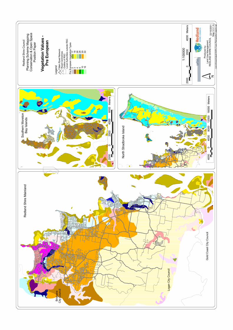
j:\ar
cinf
o\w
ork\
dpe0
19\IP
AT
own
Pla
n\po
sitio
npa
pers
.apr
Bris
bane
City
Cou
ncil Lo
gan
City
Cou
ncil
Gol
dC
oast
City
Cou
ncil
Nor
thS
trad
brok
eIs
land
Sou
ther
nM
oret
onB
ayIs
land
sR
edla
ndS
hire
Mai
nlan
dR
edla
ndS
hire
Cou
ncil
Pla
nnin
gS
chem
eM
appi
ngC
onse
rvat
ion
& O
pen
Spa
ceP
ositi
onP
aper
Veg
etat
ion
Val
ues
-P
reE
urop
ean
Lege
nd
22/1
0/20
01M
ap3.
3.1
AN
Pro
duce
dby
Land
Use
Man
agem
ent
RE
DLA
ND
SH
IRE
CO
UN
CIL
2000
020
0040
0060
00M
eter
s
4000
040
0080
0012
000
1600
0M
eter
s
2000
020
0040
00M
eter
s1:
1000
00
Pre
Eur
opea
nV
eget
atio
nT
ypes
2 3 4 9 10 16
17 18 26 28 29 30
Loca
lAut
horit
ies
outs
ide
RS
CO
utlin
eof
RS
CR
oad
Cen
trel
ines
Mai
nR
oad
Net
wor
k
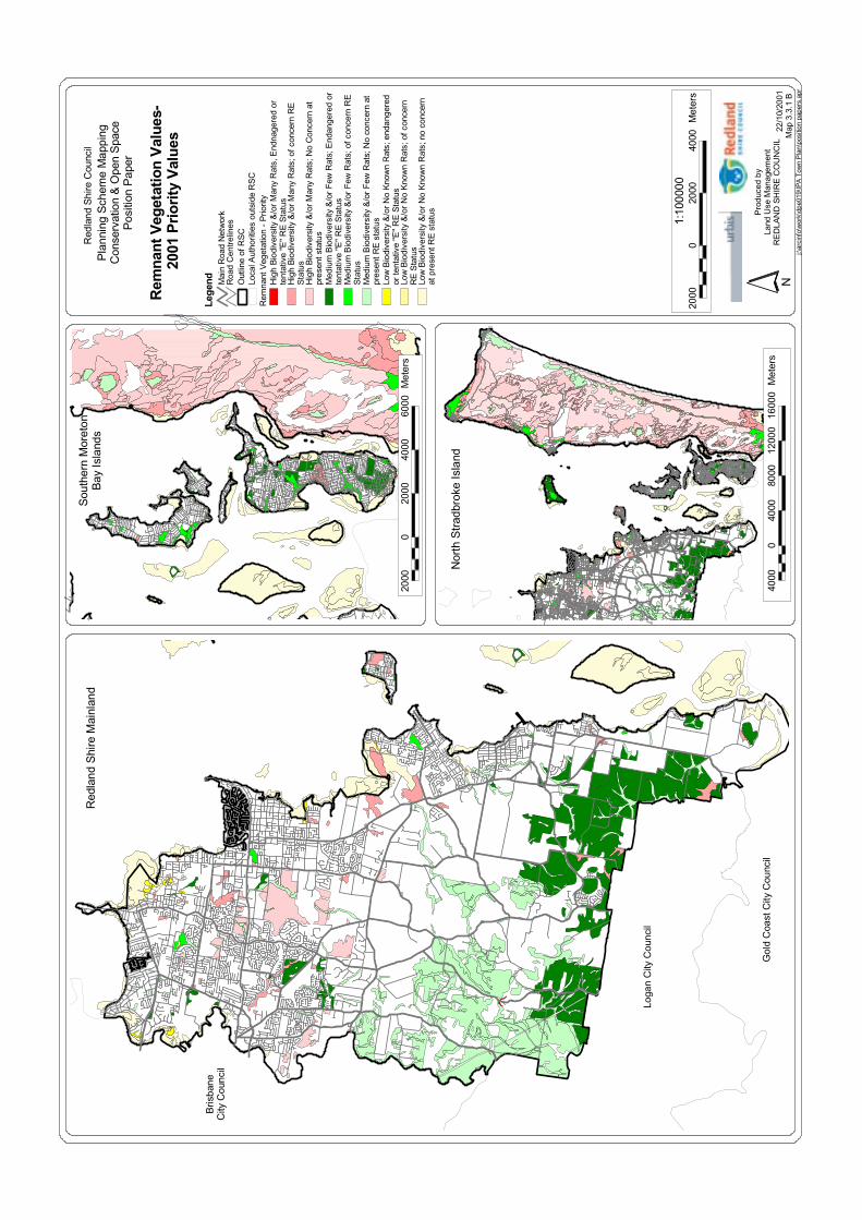
j:\ar
cinf
o\w
ork\
dpe0
19\IP
AT
own
Pla
n\po
sitio
npa
pers
.apr
Bris
bane
City
Cou
ncil
Loga
nC
ityC
ounc
il
Gol
dC
oast
City
Cou
ncil
Nor
thS
trad
brok
eIs
land
Sou
ther
nM
oret
onB
ayIs
land
sR
edla
ndS
hire
Mai
nlan
dR
edla
ndS
hire
Cou
ncil
Pla
nnin
gS
chem
eM
appi
ngC
onse
rvat
ion
& O
pen
Spa
ceP
ositi
onP
aper
Rem
nant
Veg
etat
ion
Val
ues-
2001
Pri
ori
tyV
alu
es
22/1
0/20
01M
ap3.
3.1
BN
Pro
duce
dby
Land
Use
Man
agem
ent
RE
DLA
ND
SH
IRE
CO
UN
CIL
2000
020
0040
0060
00M
eter
s
4000
040
0080
0012
000
1600
0M
eter
s
2000
020
0040
00M
eter
s1:
1000
00
Leg
end
Rem
nant
Veg
etat
ion
-P
riorit
yH
igh
Bio
dive
rsity
&/o
rM
any
Rat
s,E
ndna
gere
dor
tent
ativ
e"E
"R
ES
tatu
sH
igh
Bio
dive
rsity
&/o
rM
any
Rat
s;of
conc
ern
RE
Sta
tus
Hig
hB
iodi
vers
ity&
/or
Man
yR
ats;
No
Con
cern
atpr
esen
tsta
tus
Med
ium
Bio
dive
rsity
&/o
rF
ewR
ats;
End
ange
red
orte
ntat
ive
"E"
RE
Sta
tus
Med
ium
Bio
dive
rsity
&/o
rF
ewR
ats;
ofco
ncer
nR
ES
tatu
sM
ediu
mB
iodi
vers
ity&
/or
Few
Rat
s;N
oco
ncer
nat
pres
entR
Est
atus
Low
Bio
dive
rsity
&/o
rN
oK
now
nR
ats;
enda
nger
edor
tent
ativ
e"E
"R
ES
tatu
sLo
wB
iodi
vers
ity&
/or
No
Kno
wn
Rat
s;of
conc
ern
RE
Sta
tus
Low
Bio
dive
rsity
&/o
rN
oK
now
nR
ats;
noco
ncer
nat
pres
entR
Est
atus
Loca
lAut
horit
ies
outs
ide
RS
CO
utlin
eof
RS
CR
oad
Cen
trel
ines
Mai
nR
oad
Net
wor
k
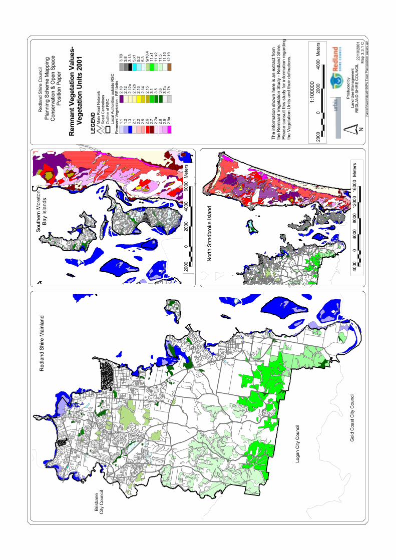
j:\ar
cinf
o\w
ork\
dpe0
19\IP
AT
own
Pla
n\po
sitio
npa
pers
.apr
Bris
bane
City
Cou
ncil
Loga
nC
ityC
ounc
il
Gol
dC
oast
City
Cou
ncil
Nor
thS
trad
brok
eIs
land
Sou
ther
nM
oret
onB
ayIs
land
sR
edla
ndS
hire
Mai
nlan
dR
edla
ndS
hire
Cou
ncil
Pla
nnin
gS
chem
eM
appi
ngC
onse
rvat
ion
& O
pen
Spa
ceP
ositi
onP
aper
Rem
nant
Veg
etat
ion
Val
ues-
Veg
etat
ion
Uni
ts20
01 22/1
0/20
01M
ap 3
.3.1
CN
Pro
duce
dby
Land
Use
Man
agem
ent
RE
DLA
ND
SH
IRE
CO
UN
CIL
2000
020
0040
0060
00M
eter
s
4000
040
0080
0012
000
1600
0M
eter
s
2000
020
0040
00M
eter
s1:
1000
00
Rem
nant
Veg
etat
ion
-R
EU
nits
1.1
1.2
1.3
2.1
2.2
2.5
2.6
2.7
2.7a
2.8
2.9
2.9a
2.10
2.12
2.12
a2.
12b
2.13
2.14
2.15
3.1
3.5
3.6
3.7a
3.7b
3.7B
3.8
3.13
5.x1
5.2
5.3
9/10
.411
.x1
11.x
211
.511
.10
12.1
9
Loca
lAut
horit
ies
outs
ide
RS
CO
utlin
eof
RS
CR
oad
Cen
trel
ines
Mai
nR
oad
Net
wor
kLE
GE
ND
The
info
rmat
ion
show
nhe
reis
anex
trac
tfro
mth
eR
emna
ntV
eget
atio
nS
tudy
-R
edla
ndS
hire
.P
leas
eco
nsul
tthi
sst
udy
for
info
rmat
ion
rega
rdin
gth
eV
eget
atio
nU
nits
and
thei
rde
finat
ions
.
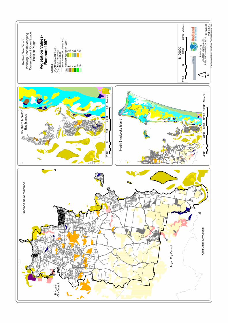
2000
020
0040
00M
eter
s1:
1000
00
4000
040
0080
0012
000
1600
0M
eter
s
2000
020
0040
0060
00M
eter
s
Pro
duce
dby
Land
Use
Man
agem
ent
RE
DLA
ND
SH
IRE
CO
UN
CIL
N22
/10/
2001
Map
3.3.
1 D
Lege
nd Mai
nR
oad
Net
wor
kR
oad
Cen
trel
ines
Out
line
ofR
SC
Loca
lAut
horit
ies
outs
ide
RS
C
302928261817
1610943219
97R
emna
ntV
eget
atio
nTy
pes
Veg
etat
ion
Val
ues
-R
emn
ant1
997
Pla
nnin
gS
chem
eM
appi
ngC
onse
rvat
ion
& O
pen
Spa
ceP
ositi
onP
aper
Red
land
Shi
reC
ounc
ilR
edla
ndS
hire
Mai
nlan
dS
outh
ern
Mor
eton
Bay
Isla
nds
Nor
thS
trad
brok
eIs
land
Gol
dC
oast
City
Cou
ncil
Loga
nC
ityC
ounc
il
Bris
bane
City
Cou
ncil
j:\ar
cinf
o\w
ork\
dpe0
19\IP
AT
own
Pla
n\po
sitio
npa
pers
.apr