Arizona Independent Redistricting Commission The Redistricting Process
1
Redistricting California: An Overview of Data & Processes to aid the Evaluation of Applicants
Karin Mac Donald, DirectorJaime Clark, Redistricting Data & Access CoordinatorStatewide Database – Berkeley [email protected]; [email protected]
http://statewidedatabase.org

2
Who we are and what we will do today:
Statewide Database: Redistricting Database for the State of California – https://statewidedatabase.org
Karin’s and Jaime’s redistricting experience
Overview of this session: Introduce Data used in Redistricting Provide Context for qualifications of applicants the ARP will look
for Provide realistic examples of how qualifications may be applied Live Demo on moving lines and how districts are constructed

3
Qualifications on which candidates will be selected:
Analytical Skills – includes ability to understand technical materials incl. maps and statistical info; resolve complex problems
Ability to be impartial – includes ability to evaluate information with an open mind, make decisions that set aside personal views/interests
Appreciation for California’s diverse demographics and geography – understanding that CA benefits from having effective participation by persons of all demographic characteristics incl. race, ethnicity, gender, sexual orientation, economic status
Applicants DO NOT need to be EXPERTS to be selected!

Analytical skills
Successful applicants should be able to: Learn about the different datasets Understand which data are used to measure
or satisfy the various criteria Ask for clarification and explanations Receive input and be able to contextualize it Weigh conflicting input and data Analyze trade-offs and make decisions
4
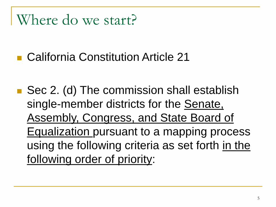
Where do we start?
California Constitution Article 21
Sec 2. (d) The commission shall establish single-member districts for the Senate, Assembly, Congress, and State Board of Equalization pursuant to a mapping process using the following criteria as set forth in the following order of priority:
5

Criterion 1: Equal Population
(1) Districts shall comply with the United States Constitution. Congressional districts shall achieve population equality as nearly as is practicable, and Senatorial, Assembly, and State Board of Equalization districts shall have reasonably equal population with other districts for the same office, except where deviation is required to comply with the federal Voting Rights Act or allowable by law.
6

Which data are used for the Equal Population Criterion? Decennial Census PL94-171 file Census block level dataset Reports total population and other variables Equal Population means assign everyone to a
district NOT only Citizens, Voters, eligible voters,
registered voters but rather EVERYONE* who was counted by the census
*there is a caveat
7

Criterion 2: Federal Voting Rights Act
(2) Districts shall comply with the Federal Voting Rights Act (42 U.S.C. Sec. 1971 and following)
Please note that there will likely be some confusion regarding the California Voting Rights Act which does NOT in any way apply to statewide redistricting
Applicants should have the analytical skills to be able to learn about the differences and explain this to the public
8

Data necessary to comply with the FVRA Two parts to comply:
Measuring/analyzing Expert conducts a Racially Polarized Voting Analysis Applicants must be able to work with their Expert(s) and Counsel to
make decisions about Majority/Minority districts Drawing a district
Applicants must be able to work with their redistricting consultant to construct districts that comply with the FVRA
Census data American Community Survey Voter Registration Statement of Vote Geography
Note that having political data available does not mean that they should or will be used for political purposes; these data are necessary for FVRA compliance
9

Criterion 3: Contiguity & Data used
(3) Districts shall be geographically contiguous
Geographic Criterion
Data used: Census geography
10

Criterion 4: Local jurisdictions & Communities
(4) The geographic integrity of any city, county, city and county, local neighborhood, or local community of interest shall be respected in a manner that minimizes their division to the extent possible without violating the requirements of any of the preceding subdivisions. A community of interest is a contiguous population which shares common social and economic interests that should be included within a single district for purposes of its effective and fair representation.
11

Data to meet Criterion 4 Cities, Counties, Cities and Counties? Census geography
Neighborhoods? Not readily available; Public testimony, Data/
Geography submitted by Public, Cities, etc.
Communities of Interest? Not readily available; Public testimony, Data/
Geography submitted by Public, local officials, etc.; sometimes supplemented with other data.
12

Criterion 5: Compactness & Data used (5) To the extent practicable, and where this
does not conflict with the criteria above, districts shall be drawn to encourage geographical compactness such that nearby areas of population are not bypassed for more distant population.
Geographic Criterion
Data used: Census Geography
13
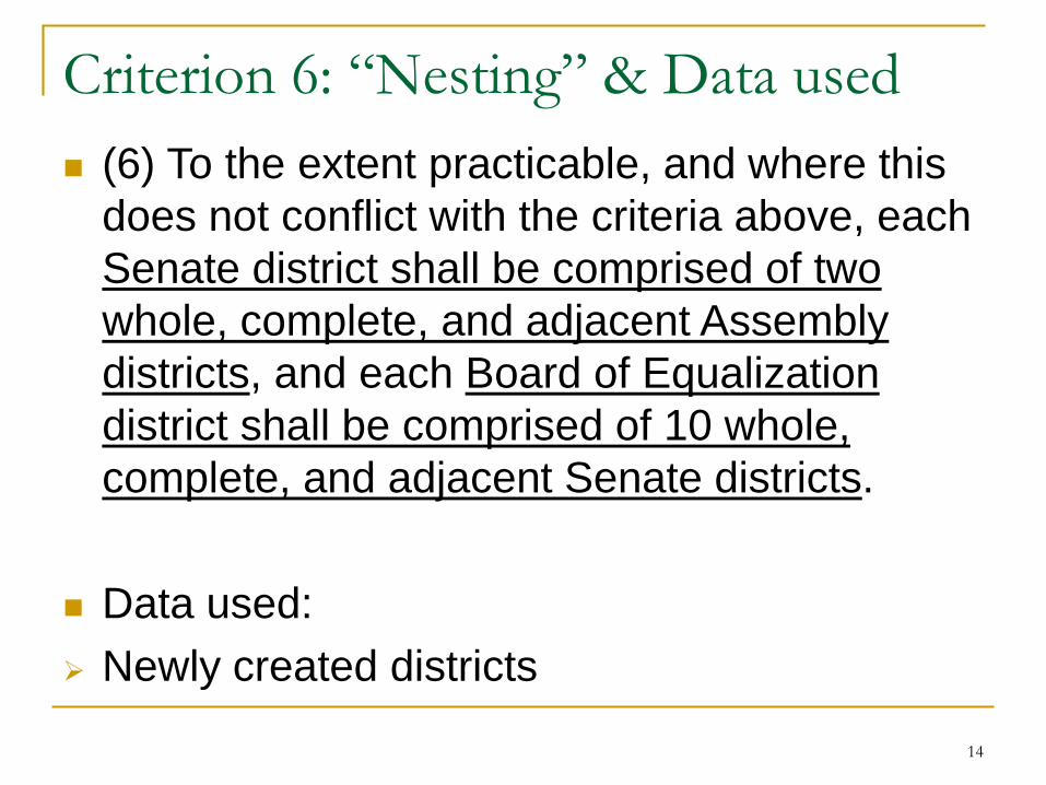
Criterion 6: “Nesting” & Data used (6) To the extent practicable, and where this
does not conflict with the criteria above, each Senate district shall be comprised of two whole, complete, and adjacent Assembly districts, and each Board of Equalization district shall be comprised of 10 whole, complete, and adjacent Senate districts.
Data used: Newly created districts
14

15
Redistricting Criteria and Data used: Equal Population – Decennial Census; PL94-171file Compliance with the Federal Voting Rights Act; PL94-
171, Statement of Registration, Statement of Vote, Citizen Voting Age Population from American Community Survey (ACS)
Contiguity – Census Geography Respect for City and County boundaries – Census
Geography Respect for Neighborhoods – Public Testimony,
Data/Geography submitted by Public, Cities/Counties, etc.
Respect for Communities of Interest – Public Testimony, Data/Geography submitted by Public
Compactness – Census Geography Nesting – Newly created districts

The Decennial Census Conducted every 10 years since 1790 Determines the number of people living in the
US “Count people once, only once and in the right
place” The only “count” of the population Provides a ‘snapshot’ of the US population Collects data from every household and more Previously known as the “short form”
Census Day is April 1 2020
16

What does the Census ask everyone? Basic questions including: Name Age Race Hispanic/Latino/Spanish Origin Sex Relationship Owner/Renter Will NOT ask a Citizenship question
17

Census Data – P.L. 94-171 Mission: Provide the officers or public bodies having initial
responsibility for the legislative apportionment or districting of each State an opportunity to identify the geographic areas for which specific tabulations of population are desired and to deliver those tabulations in a timely manner.
Identified “geographic areas desired”:• Census Tabulation Blocks
Requirements:• Conduct the program in a non-partisan manner• Deliver the tabulations to the governor and the officers or
public bodies having initial responsibility for the legislative apportionment or districting of each State no later than 1 year from Census Day (April 1, 2021)
18

What is in the P.L. 94-171 datafile? Final 2018 Prototype P.L. 94-171 Redistricting Data File Design
Table P1 – Race Table P2 – Race for the Population 18 Years and Over Table P3 – Hispanic or Latino, and not Hispanic or Latino by
Race Table P4 – Hispanic or Latino, and not Hispanic or Latino by
Race for the Population 18 and Over Table H1 – Occupancy Status (Housing)
New Table: Table P5 – Group Quarters Population by Group Quarters Type*
*Group quarters table includes only total population
19

The American Community Survey Aka ACS Replaced the “long form” starting in 2005 2010 was the first “short form only” census ACS is conducted monthly Is released yearly Collected data include: educational attainment,
income, housing costs, disability status, employment and more
Collects data on Citizenship Releases Citizen Voting Age Population (CVAP)
20

More about the ACS The ACS is not a “count” of the population It produces estimates that are comparable for
geographies recognized by the Census bureau Also described as a “portrait” of the population 5-year ACS estimates are released yearly for
small geographies 3-year and 1-year estimates are released for
larger geographies ACS data are NOT released on the census block
level
21

22
PL94 Data are Tabulated and Reported for All Geographic Entities
Census Geography
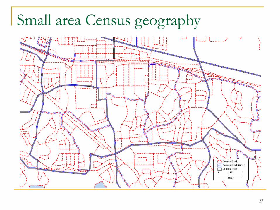
Small area Census geography
23
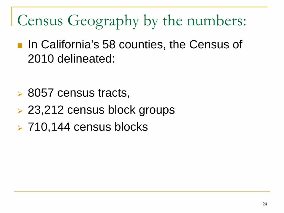
Census Geography by the numbers: In California’s 58 counties, the Census of
2010 delineated:
8057 census tracts, 23,212 census block groups 710,144 census blocks
24

Election Data Necessary for FVRA assessment and
compliance Used along with P.L.94-171 data and ACS Consist of two datasets: SOR: Statement of Registration SOV: Statement of Vote
Collected by Registrars of Voters and Secretary of State
SOR: Individual level dataset SOV: Precinct level dataset
25

A note about geographies The datasets we have discussed are released
on different geographies: Census blocks (smallest) Census block groups and tracts Election precincts
Census geography: maintained by Census bureau stays constant for 10 years
Precinct geography: Maintained by 58 Registrars of Voters Organizing units to conduct elections and release
results Change frequently - often with each election
26

Election Precincts versus Census Blocks
27

Census Blocks versus Election Precincts
28

What is a Redistricting Database? A Redistricting Database solves the problem
of conflicting, frequently changing geographies
It contains various datasets, merges them and releases them on the census block level
It typically contains: Census Data American Community Survey Data (CVAP) Statement of Vote Data Statement of Registration Data
29
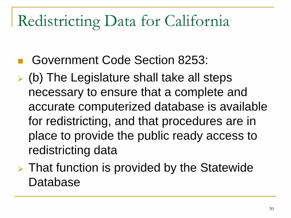
Redistricting Data for California
Government Code Section 8253: (b) The Legislature shall take all steps
necessary to ensure that a complete and accurate computerized database is available for redistricting, and that procedures are in place to provide the public ready access to redistricting data
That function is provided by the Statewide Database
30

The Statewide Database The Redistricting Database for the State of
California Part of Berkeley Law on the UC Berkeley
campus Longitudinal dataset (back to 1992) Public, non-partisan, free-of-charge Available in different formats Provides data and geography for the entire
State of California
31

https://statewidedatabase.org - Our Data:
Census – Pl94-171 Statement of Vote from statewide elections Statement of Registration from statewide
elections American Community Survey: Citizen Voting
Age Population (CVAP) Precinct data and geography Each year ending with 1: A redistricting
dataset containing new census data and multiple elections on the census block level
32

33
Total Deviation
% Total Deviation
Deviation Range
%Deviation Range
Average Deviation
% Average Deviation
Assembly 9,224 1.981% -4,573 to 4,651
-0.982% to 0.999% 2,357 0.506%
Senate 18,489 1.985% -9,226 to 9,263
-0.991% to 0.995% 4,185 0.449%
Congress 2 0.000% -1 to 1
-0.014% to 0.014% 0.66 0.000%
BOE 168,718 1.812% -93,132 to 75,586
-1.000% to 0.812% 58,709 0.630%
Equal Population in Practice

34
Federal Voting Rights Act Considerations

Reallocation of Inmate Data for Census 2020 AB420(Davis) and AB2172(Weber) Require the California Department of
Corrections and Rehabilitation (CDCR) to provide a dataset to the Citizen Redistricting Commission (CRC) and the Legislature between April 1, 2020, and July 1, 2020 regarding the last known place of residence of each inmate in a facility under the control of the CDCR on April 1, 2020.
Requires CDCR to provide information about the ethnicity, as identified by the inmate, and any information about the race of the inmate to the extent such information is maintained by CDCR.
35

Reallocation Data project cont. Requires the Legislature, in coordination with
the CRC, to ensure that the information provided by CDCR is included in the computerized database that is used for redistricting.
Requests the CRC to deem each incarcerated person as residing at his or her most recent residential address, rather than at the institution of his or her incarceration
36

What does this mean? 1. California will be adjusting the data it receives
from the Census i.e. the PL94-171 Total Population, Race and Ethnicity
Counts will be adjusted such that Inmates under the control of the CDRC on Census Day (in group quarters) are reallocated to their last known residential address
2. The Citizen Redistricting Commission must consider whether to use the adjusted dataset for redistricting
3. The CRC must be able to explain to the public why the redistricting data for California are slightly different from the PL94-171 data as released by the census.
37

To summarize:
Applicants for the Redistricting Commission should possess the analytical skills to: Learn about the different datasets that are part of
a Redistricting database Understand why redistricting datasets are built on
the census block level Make decisions about the adjusted dataset Explain to the public why data they may be using
as part of a privately owned software package may differ from the official redistricting dataset
38

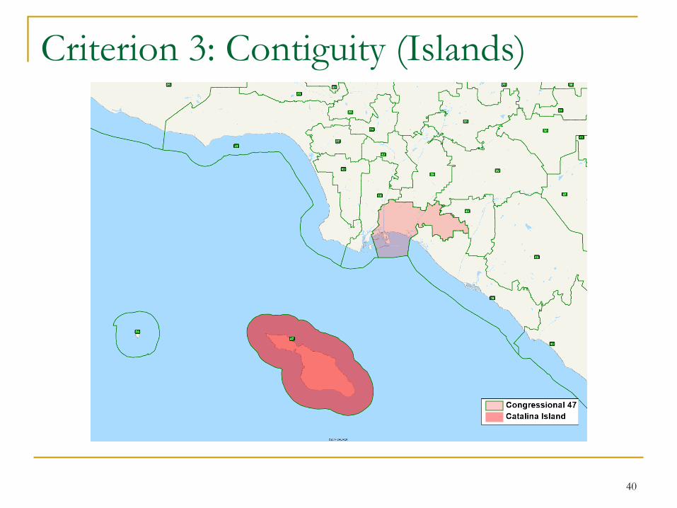
(3) Districts shall be geographically contiguous.
Definition: A district in which all parts are connected to each other
in other words: A district in which one may travel from any
location to any other location without crossing the district boundary
Census geography is used to meet this criterion
39
Criterion 3: Contiguity
40
Criterion 3: Contiguity (Islands)

41
Criterion 3: Contiguity (Bridge)
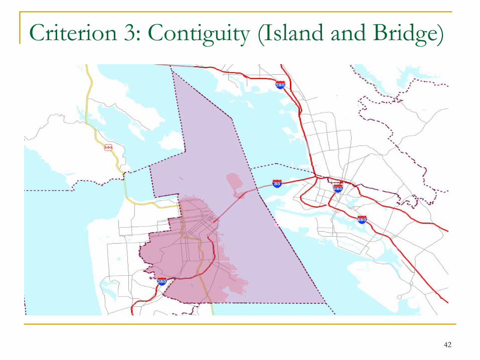
Criterion 3: Contiguity (Island and Bridge)
42
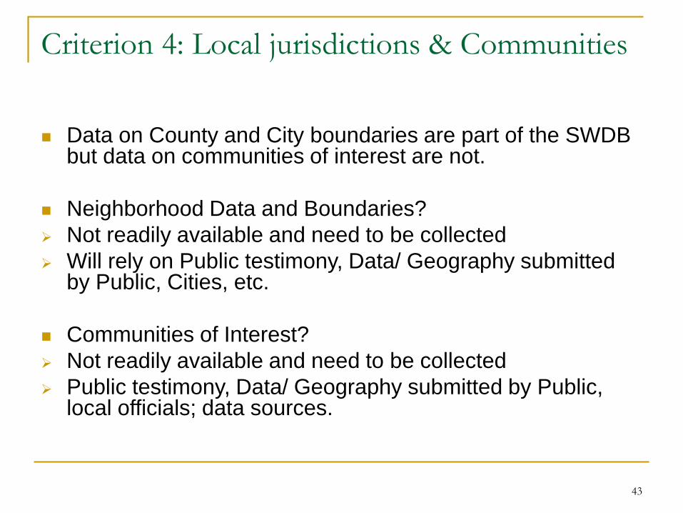
Data on County and City boundaries are part of the SWDB but data on communities of interest are not.
Neighborhood Data and Boundaries? Not readily available and need to be collected Will rely on Public testimony, Data/ Geography submitted
by Public, Cities, etc.
Communities of Interest? Not readily available and need to be collected Public testimony, Data/ Geography submitted by Public,
local officials; data sources.
43
Criterion 4: Local jurisdictions & Communities

Neighborhoods, Communities and Public Input
Government Code Section 8253: The commission shall establish and
implement an open hearing process for public input and deliberation that shall be subject to public notice and promoted through a thorough outreach program to solicit broad public participation in the redistricting public review process
44

Communities of Interest: what are they?
California Constitution Article 21 provides definitions and some examples:
A community of interest is a contiguous population which shares common social and economic interests that should be included within a single district for purposes of its effective and fair representation.
Examples of such shared interests are those common to an urban area, a rural area, an industrial area, or an agricultural area, and those common to areas in which the people share similar living standards, use the same transportation facilities, have similar work opportunities, or have access to the same media of communication relevant to the election process.
Communities of interest shall not include relationships with political parties, incumbents, or political candidates.
45

How to define Communities of Interest Through a public input process that solicits
information from those that live or work in the community
Request oral or written testimony about the community
Ask the public for input on: What bonds the community/what is the
commonality? Where is the community located? What are its
borders Why should it stay together?
46

A note about Communities of Interest
They may or may not be supported by quantitative data, such as Census or American Community Survey (ACS) data (and don’t need to be)
There may be conflicting information about a Community of Interest
They can vary in size and range from small to large They can have a ‘current’ interest or a ‘goal’ to binds them Neighborhoods and Communities of Interest are part of the
same Criterion (4) and are not ranked within the Criterion; i.e. they hold the same weight as Cities and Counties.
The law does not limit the kinds of interests that bind a community (exception: no political parties, candidates or incumbents, please!)
47

Communities of Interest: Examples Economic interests: Current situation -- common employment or
economic opportunities (or lack thereof). Goals -- expanding opportunities, development,
bringing in businesses and jobs, etc. Social interests: Current -- schools, culture, transportation, parks Goals -- improving recreation opportunities or
public safety, etc.
48

Community of Interest Examples cont. Foothill counties sharing the same watershed Communities organizing around a historic
neighborhood Cities with a shared transportation corridor Cities with a commonality of economic interests Areas with a high non-English speaking cultural
community Organized neighborhoods with an active group Communities organizing around economic
development Coastal communities working to fight off-shore
drilling
49

Where is L.A.’s Koreatown?
50
https://commons.wikimedia.org/wiki/File:Visual_depiction_of_Koreatown_boundaries_according_to_different_sources.png

Criterion 5: Compactness (5) To the extent practicable, and where this
does not conflict with the criteria above, districts shall be drawn to encourage geographical compactness such that nearby areas of population are not bypassed for more distant population.
Census Geography and Population are used to measure this criterion
51

Criterion 5: Compactness
Addresses the geography of the district Assumed to “guard against all types of
gerrymandering” “drastic departures from compactness are a signal that something may be amiss”
There are hundreds of measures that have been developed to measure compactness; note: CA has a definition
Courts have used the “eyeball approach”and said that “appearances do matter”
52

Criterion 5: Compactness
It can be difficult to create a compact district There may be trade-offs with other criteria,
i.e. Cities may not be compact but are part of a higher ranked criterion
It can be difficult to ascertain whether a district is non compact without having more information
Nesting two compact Assembly districts may result in a non-compact Senate district
53
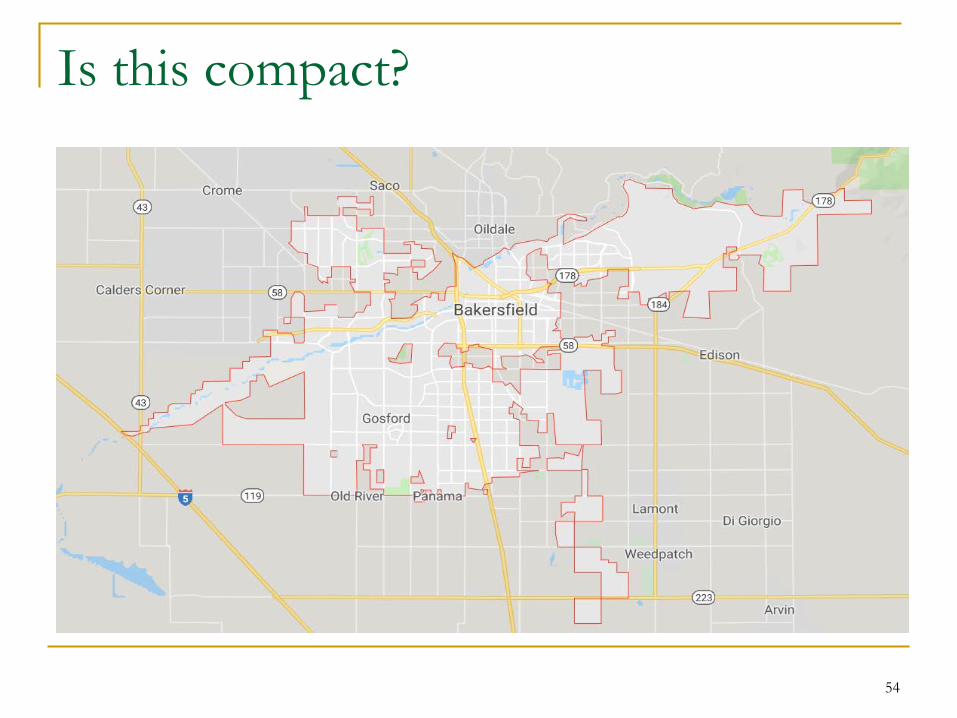
Is this compact?
54

55
Compactness and the resolution of complex problems
Lessons learned from research:
Criteria Interaction effects on Compactness
Majority/Minority Seats Preserving City and County Boundaries Respecting Communities of Interest

Criterion 6: Nesting (6) To the extent practicable, and where this
does not conflict with the criteria above, each Senate district shall be comprised of two whole, complete, and adjacent Assembly districts, and each Board of Equalization district shall be comprised of 10 whole, complete, and adjacent Senate districts.
The newly created districts are used for this criterion
It is the lowest ranked criterion
56

Nesting in Research Trade-offs with other criteria Constrains line drawing process May ‘double a wrong’ if Assembly Districts did
not meet the needs of a community City Splits Community of Interest Splits
Compactness
57

Nesting in Practice
58

59
Qualifications on which candidates will be selected:
Analytical Skills – includes ability to understand technical materials incl. maps and statistical info; resolve complex problems
Ability to be impartial – includes ability to evaluate information with an open mind, make decisions that set aside personal views/interests
Appreciation for California’s diverse demographics and geography – understanding that CA benefits from having effective participation by persons of all demographic characteristics incl. race, ethnicity, gender, sexual orientation, economic status
Applicants DO NOT need to be EXPERTS to be selected!

What’s next?
Line drawing and illustration of criteria implementation
THANK YOU!
60