REDEVELOPMENT PLAN FOR THE ALBANY...
21
REDEVELOPMENT PLAN FOR THE ALBANY AVENUE/WOODLAND STREET PROJECT HARTFORD REDEVELOPMENT AGENCY DEPARTMENT OF DEVELOPMENT SERVICES 250 CONSTITUTION PLAZA, 4 th FLOOR HARTFORD, CONNECTICUT 06103 APPROVED BY THE HARTFORD REDEVELOPMENT AGENCY ON OCTOBER 13, 2005
Transcript of REDEVELOPMENT PLAN FOR THE ALBANY...
REDEVELOPMENT PLAN
FOR THE
ALBANY AVENUE/WOODLAND STREET PROJECT
HARTFORD REDEVELOPMENT AGENCY DEPARTMENT OF DEVELOPMENT SERVICES 250 CONSTITUTION PLAZA, 4th FLOOR HARTFORD, CONNECTICUT 06103 APPROVED BY THE HARTFORD REDEVELOPMENT AGENCY ON OCTOBER 13, 2005
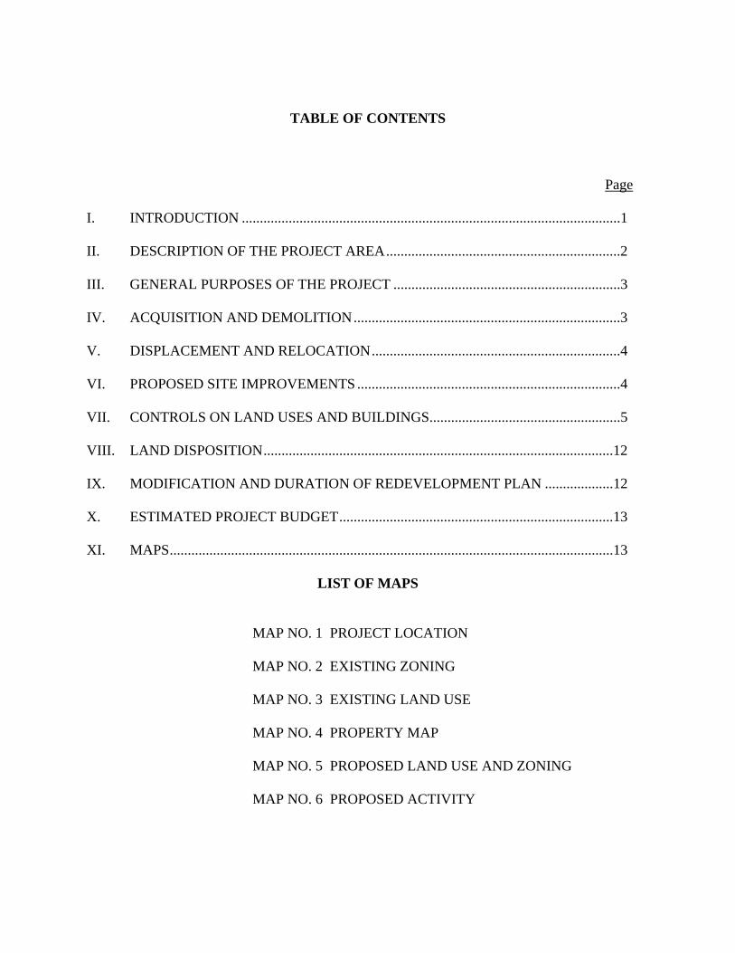
TABLE OF CONTENTS
Page I. INTRODUCTION .........................................................................................................1 II. DESCRIPTION OF THE PROJECT AREA.................................................................2 III. GENERAL PURPOSES OF THE PROJECT ...............................................................3 IV. ACQUISITION AND DEMOLITION..........................................................................3 V. DISPLACEMENT AND RELOCATION.....................................................................4 VI. PROPOSED SITE IMPROVEMENTS .........................................................................4 VII. CONTROLS ON LAND USES AND BUILDINGS.....................................................5 VIII. LAND DISPOSITION.................................................................................................12 IX. MODIFICATION AND DURATION OF REDEVELOPMENT PLAN ...................12 X. ESTIMATED PROJECT BUDGET............................................................................13 XI. MAPS...........................................................................................................................13
LIST OF MAPS
MAP NO. 1 PROJECT LOCATION MAP NO. 2 EXISTING ZONING MAP NO. 3 EXISTING LAND USE MAP NO. 4 PROPERTY MAP MAP NO. 5 PROPOSED LAND USE AND ZONING MAP NO. 6 PROPOSED ACTIVITY
1
I. Introduction
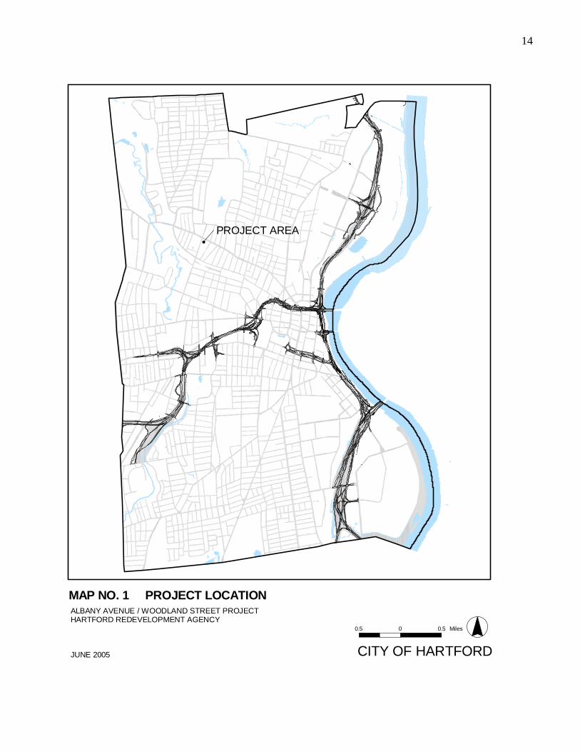
The Albany Avenue/Woodland Street Project (thereinafter called the “Project”) is located
northwest of the City’s downtown within the Upper Albany Neighborhood (see Map #1
Project Location). It is a deteriorated area of approximately 1.91 acres of land more than
twenty-six (26) percent of which is vacant.
Albany Avenue is a major corridor for the Hartford region linking commuters between
suburban towns in the west and north and the downtown area. Generally these commuters do
not utilize retail, services or business opportunities along Albany Avenue. Upper Albany
Avenue contains a mix of retail and service uses but residents in the neighborhood are
presently taking advantage of shopping options in neighboring West Hartford and Bloomfield.
Many of the businesses in this area are associated with locally-owned grocery/liquor
establishments, personal services and restaurants or take-outs principally targeted to walk-in
traffic. Throughout the Upper Albany Avenue retail corridor there is evidence of the
Caribbean/West Indian, African-American and Hispanic influence that is the multi-cultural
dimension of the local population base.
This Redevelopment Plan (thereinafter called the “Plan”) provides for the creation of
neighborhood business development along the Albany Avenue and Woodland Street frontage.
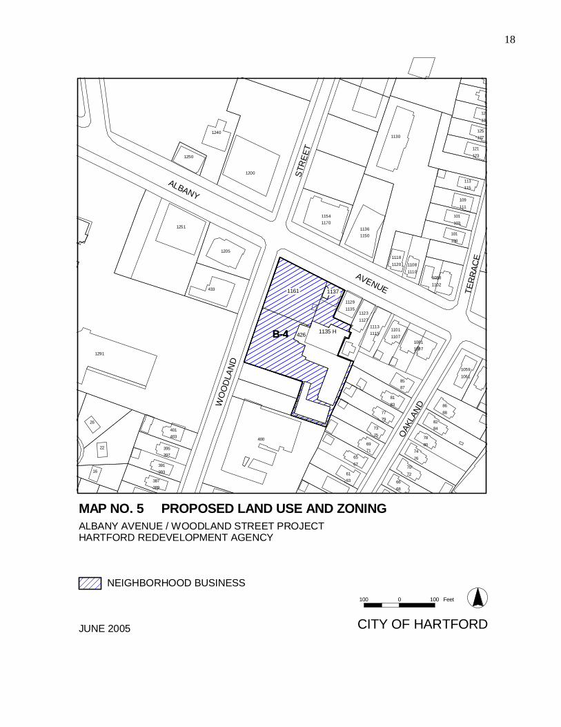
Neighborhood business allows most types of retail and office uses. Residential uses are
allowed on upper floors of mixed use buildings. The Plan proposes to change the existing
zone district from B-3 to B-4, to conform with the adjacent B-4 zone fronting on Albany
Avenue. The proposed land uses within the Project area are in conformity with the City of
Hartford’s Plan of Development, adopted by the Commission on the City Plan on June 4,
1996.
The Plan which has been prepared by the Hartford Redevelopment Agency (hereinafter called
“Agency”) is in accordance with the provisions of Chapter 130 of the Connecticut General
Statutes. Due to the small size of the Project, it has the potential to achieve visible results in a
relatively short period of time as well as to make a substantial impact on the area as a whole.
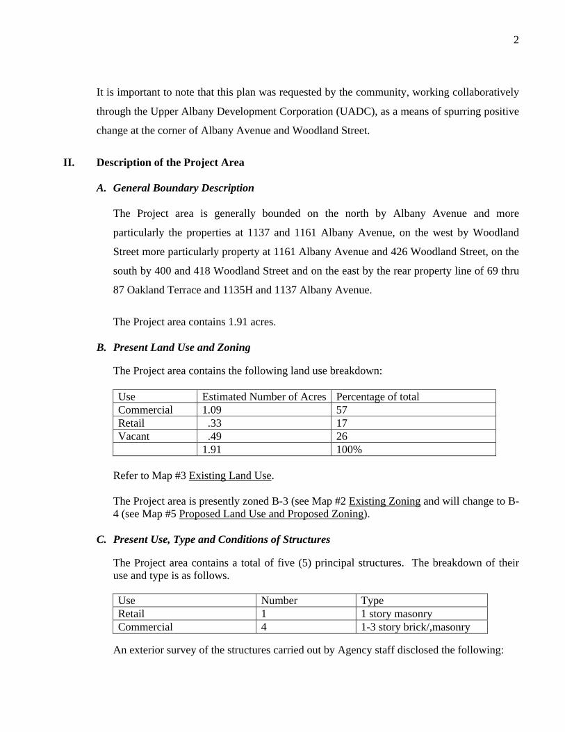
2
It is important to note that this plan was requested by the community, working collaboratively
through the Upper Albany Development Corporation (UADC), as a means of spurring positive
change at the corner of Albany Avenue and Woodland Street.
II. Description of the Project Area
A. General Boundary Description
The Project area is generally bounded on the north by Albany Avenue and more
particularly the properties at 1137 and 1161 Albany Avenue, on the west by Woodland
Street more particularly property at 1161 Albany Avenue and 426 Woodland Street, on the
south by 400 and 418 Woodland Street and on the east by the rear property line of 69 thru
87 Oakland Terrace and 1135H and 1137 Albany Avenue.
The Project area contains 1.91 acres.
B. Present Land Use and Zoning
The Project area contains the following land use breakdown: Use Estimated Number of Acres Percentage of total Commercial 1.09 57 Retail .33 17 Vacant .49 26 1.91 100%
Refer to Map #3 Existing Land Use.
The Project area is presently zoned B-3 (see Map #2 Existing Zoning and will change to B-4 (see Map #5 Proposed Land Use and Proposed Zoning).
C. Present Use, Type and Conditions of Structures
The Project area contains a total of five (5) principal structures. The breakdown of their use and type is as follows.
An exterior survey of the structures carried out by Agency staff disclosed the following:
Use Number Type Retail 1 1 story masonry Commercial 4 1-3 story brick/,masonry
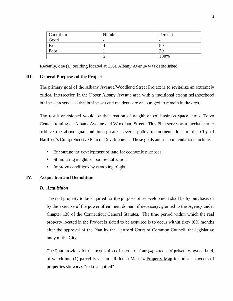
3
Condition Number Percent Good - - Fair 4 80 Poor 1 20 5 100%
Recently, one (1) building located at 1161 Albany Avenue was demolished.
III. General Purposes of the Project
The primary goal of the Albany Avenue/Woodland Street Project is to revitalize an extremely
critical intersection in the Upper Albany Avenue area with a traditional strong neighborhood
business presence so that businesses and residents are encouraged to remain in the area.
The result envisioned would be the creation of neighborhood business space into a Town
Center fronting an Albany Avenue and Woodland Street. This Plan serves as a mechanism to
achieve the above goal and incorporates several policy recommendations of the City of
Hartford’s Comprehensive Plan of Development. These goals and recommendations include:
Encourage the development of land for economic purposes
Stimulating neighborhood revitalization
Improve conditions by removing blight
IV. Acquisition and Demolition
D. Acquisition
The real property to be acquired for the purpose of redevelopment shall be by purchase, or
by the exercise of the power of eminent domain if necessary, granted to the Agency under
Chapter 130 of the Connecticut General Statutes. The time period within which the real
property located in the Project is slated to be acquired is to occur within sixty (60) months
after the approval of the Plan by the Hartford Court of Common Council, the legislative
body of the City.
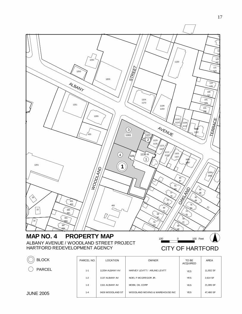
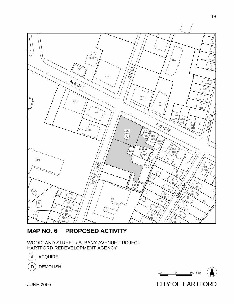
The Plan provides for the acquisition of a total of four (4) parcels of privately-owned land,
of which one (1) parcel is vacant. Refer to Map #4 Property Map for present owners of
properties shown as “to be acquired”.
4
E. Demolition
Five (5) principal structures are slated for demolition under this Plan. They are located at
1135H and 1137 Albany Avenue and three (3) structures at 426 Woodland Street. See
Map #6 Proposed Activity. These structures are in fair to poor condition. The acquisition
and demolition of these structures will provide the land needed to assemble 1.91 acres of
land for disposition. This will allow the new construction of a neighborhood business
Town Center development fronting on Albany Avenue and Woodland Street.
V. Displacement and Relocation
It is anticipated that three (3) businesses will be displaced. The retail and commercial
operations that are to be displaced are a take-out fast food facility, an automotive repair shop
and a furniture and merchandise storage facility.
The Agency is ultimately responsible for the relocation of these three (3) businesses as the
result of actions that are carried out in accordance with the Plan.
Agency staff will maintain continuous contact with the relocation process in order to minimize
hardship. Relocation assistance will be furnished in accordance with State and Federal
statutory requirements specifically the Federal Uniform Relocation Assistance and Real
Property Acquisitions Policies Act of 1970, as amended, and the State Uniform Relocation
Assistance Act.
It will be the policy of the Agency to avoid evictions except where tenants fail to honor their
obligations to the Agency.
VI. Proposed Site Improvements
The Project area is currently serviced by Albany Avenue and Woodland Street which have
curbs and sidewalks and is also serviced by all major utilities. At present, no street or site
improvements are anticipated. The future improvement of the intersection of Albany Avenue
and Woodland Street is part of the Transportation Improvement Program for review for the
5
Capitol Region dated February 16, 2001 that was submitted to the Connecticut Department of
Transportation for review.
VII. Controls on Land Uses and Buildings
The following sections set forth both general and specific land use and building controls which
the Agency considers to be the minimum required to implement the Albany Avenue/Woodland
Street Plan. Any variations from these controls must be justified by redevelopers in a written
statement, with final determination to be made by the Agency.
F. General Controls
The redevelopment of all parcels and new construction within the Project area shall
conform to the following controls where applicable:
1. The Redevelopment Plan for the Albany Avenue/Woodland Street Project
adopted by the Agency and approved by the Court of Common Council.
2. The City of Hartford Zoning Ordinance, adopted February 26, 1968 with
amendments to date.
3. The State of Connecticut Building Code with amendments to date.
The most restrictive provision of these documents with respect to a particular condition
shall govern. During the period for which these controls are in effect, any new
construction expansion or reuse of property shall be in compliance with the controls and
regulations set forth in this document.
The Agency may permit the short term use of cleared land for active parking on a license
or lease basis if it is determined that such use will not impede further development of the
Project area. Any license or lease agreements shall be in accordance with the City of
Hartford Code. Other uses serving a community function may be acceptable.
6
The Agency may establish such interim uses as it deems desirable and feasible in the
public interest on property which has been acquired and not yet sold to a developer
provided such uses do not have an adverse affect on any adjacent property or inhibit the
disposition of such property.
G. Specific Controls
The following controls shall apply to all new construction in the project area.
1. Building Height
New structures will not be greater than three nor less than two stories in height.
a) The minimum neighborhood business floor to floor height will not be less
than eleven feet.
b) The minimum residential floor to floor height will not be less than ten feet.
2. Building Design
a) New structures shall recognize in their design the architecture of vintage
neighboring structures in terms of overall proportion, window proportion,
solid-to-void proportion, solid-to-void rhythms, material, texture, color, and
the relationship of architectural details and roof shapes. Existing structures
are faced, for the most part, with red brick laid in a running band with belt
and water table courses. Windows have a height-to-width ratio of two to
one or greater and are accented with either stone lintels or segmental arches.
Roofs are generally flat with pronounced cornices or have shallow pitches
with pronounced overhangs.
b) Brick will be the predominant material used for the exterior finish of new
buildings. Generally, vintage architectural styles shall predominate regard-
ing new buildings proposed within the Project.
7
c) New structures where feasible and practical, shall be built to the building
line.
d) New buildings should front onto the street. The two exterior street facing
walls on the southeast corner of Albany Avenue and Woodland Street
should be considered as building fronts and should be designed as such.
3. Parking
For all areas, the following general requirements are stipulated:
a) Parking for neighborhood business uses will be provided off street, at the
rate of 1.0 space for each 600 square feet of gross floor area.1
b) Parking for office business uses will be provided off street, at the rate of 1.0
space for each 500 square feet of gross floor area.1
c) The maximum number of on-site parking spaces for non-residential uses
shall not exceed the minimum requirements by more than twenty percent. d) Development standards:
1) Parking stalls shall not be located closer than ten (10) feet from any
building containing residential units.
2) Parking spaces shall be located a minimum of 3.0 feet from any building
used for retail and/or office purposes and also screened from any
property line.
1 Floor area is defined as floor area used for service to the public including
areas occupied by equipment used for the display of merchandise. It shall
not include areas used principally for non-public areas as defined under
Section 35-945 of the Hartford Zoning Ordinance.
8
3) Parking areas shall be provided with landscaped islands and strips to the
maximum feasible between rows of parking stalls.
Buffer landscaped strips, five feet wide at minimum, shall be provided
along front property lines. Long unbroken rows of parking stalls are to
be avoided as much as possible, by the installation after every ten (10)
stalls, of a landscaped island that is at least nine feet in width and
eighteen (18) feet in length.
Islands and strips shall be landscaped in entirety with grass or other
ground cover and shall be planted with trees of at least 3.5 inch caliper
at time of planting. Trees in planting strips shall be spaced apart at 30
feet on center
4) All parking areas are to be paved and curbed.
5) Parking areas that abut adjacent property are to be screened with a
masonry wall or other architectural or landscape divide that will
effectively screen cars from view.
6) The perimeter of parking lots will be planted with deciduous trees, of a
minimum 3.5 inch caliper, placed on thirty-foot centers.
7) Parking lots shall be lit at night to a maintained minimum of one foot
candle. Light is to be sharply cut off at property lines, and no light
source is to be visible from any residential unit within and adjacent to
the Project area.
9
4. Screening and Location of Service Facilities
Trash collection facilities and other potentially unsightly areas that are visible
from adjacent properties, from residential units within the project area, or from
public rights-of way are to be screened from view by solid walls, at least five
feet in height, that are architecturally compatible with the buildings within the
Project area. All service areas are to be located in such a manner that neither
pedestrian nor vehicular traffic will ever be blocked by service vehicles.
5. Walkways
Walkways separate from driveways and parking areas shall be provided for
convenient pedestrian access to all entryways of structures within the project.
6. Landscaping
All areas not occupied by a structure, and not required for parking areas,
driveways, walkways or loading areas are to be landscaped with grass, ground
cover, trees, shrubs or other plantings, or improved as pedestrian areas with
textured paving materials, seating and other pedestrian amenities. Street trees
of a minimum 3.5 inch caliper, at time of planting, are to be planted at a ratio of
one tree for every twenty-five feet of street frontage where feasible.
7. Signs
a) Signs are permitted only for the purpose of identifying on-premises
business establishments, and are to be one of the following types and sizes.
1. Signs displayed on business premises with reference to any of all of the
following: the business or activity carried on, the goods sold or services
provided; and, the names and qualifications of the person, partnership or
corporation carrying on such business or activity or supplying given
goods or services are limited to one sign in area when:
10
a. the use is not on the ground floor or,
b. the use is on the ground floor and the establishment does not have
shop windows equal in area to fifty percent of the establishment’s
street front elevation, measured to an overall height of eleven feet.
2. Signs displayed on business premises with reference to any or all of the
following: the business or activity carried on; the goods sold or the
services provided; and, the names and qualifications of the person,
partnership, or corporation carrying on such business or activity or
supplying given goods and services, provided that such activity is
contained on the ground floor of the premises, and when:
a. the shop or establishment in question has shop windows equal in
area to fifty percent or greater of the shop’s street frontage
elevation measured to an overall height of eleven feet;
b. the space occupied by such a sign on any external face of the
building does not exceed ten percent of the overall area of that
face measured to an overall height of eleven feet;
c. the sign is architecturally compatible with the structure, and does
not rise higher than two feet below the sill of any upper story
window.
3. Signs of a temporary nature for the purposes of leasing or sale of the
property on which they are located, and signs of a temporary nature
advertising local events and activities are permitted. These signs are
restricted in size to nine square feet and shall be removed promptly or
within one week after the designated activity has ceased.
b) Lettering painted on windows is exempt from the above area requirements
providing its height does not exceed three inches and the total area of the
11
copy does not exceed five percent of the glazed area of the window upon
which it is applied.
c) No more than three faces and one logo type are permitted on any sign.
e) Operable awnings, with the name of the on-premises establishment, are
permitted in addition to other permitted signs provided the copy applied to
the awning does not exceed ten percent of the area of the awning.
f) If multiple enterprises are to be found in a single structure, the permitted
sign (s) of each enterprise are to be coordinated across the building face in
terms of placement, proportion, and graphic quality.
g) Free standing signs and signs which advertise goods and services not
procured on the plot on which such sign is located are prohibited.
h) Roof top signs are prohibited.
i) All sign requests are to be submitted to the Redevelopment Agency for
review and administrative approval prior to application for a sign permit.
8. Additional Requirements for Submission
a) Redevelopers shall submit an illustrative site plan that demonstrates
compliance with all controls listed herewith and includes a preliminary
landscape plan. Submission of a separate final landscape plan, prepared by
a registered landscape architect is also required. The B-4 district is a
neighborhood retail business district that is characterized by the traditional
urban storefront business. As it is oriented to pedestrian traffic, the B-4
district prohibits such heavy commercial operations as gasoline sales, auto
sales and restaurants with drive-through windows. Residential uses are also
permitted and are often found on the upper floors of structures with ground
level retailers.
12
VIII. Land Disposition
After the land has been prepared for redevelopment, the Agency will arrange for the sale of
this property to one or more redevelopers for the uses specified in the Plan. The Project has a
total disposition area of 1.91 acres.
The Agency will publicly announce the availability of land and solicit proposals from
interested redevelopers using the standard Agency Request for Proposal (RFP) process.
Redevelopers shall be nominated as Tentative Developer to carry out the Plan on the basis of
the submission of an outstanding design plan and overall capability to carry out the proposed
redevelopment, pursuant to standard Agency requirements. Upon selection, the redeveloper
nominations are given 120 days to comply with these requirements. Upon satisfactory
compliance with these requirements, selected redevelopers will be granted initial authorization
to carry out the proposal. No redeveloper shall receive final approval to enter into a land
disposition agreement with the Agency until the Agency is assured of the financial ability of
the redeveloper to undertake the redevelopment and has met all standard Agency requirements.
Any contract for sale of Agency property in this Project shall be approved by the Hartford
Court of Common Council before final approval of the Agency.
IX. Modification and Duration of Redevelopment Plan
H. Modification
This Plan may be modified at any time by the Agency, provided if it is modified after the
lease or sale of real property in the Project area, the modification must be consented to by
the redeveloper or redevelopers of such real property or their successors in interest, whose
interest is affected by the proposed modification. Where the proposed modification will
substantially change the Plan as previously approved by the Hartford Court of Common
Council, the modification must similarly be approved by said Court of Common Council.
I. Duration
This Plan and any modification thereof shall be in full force for a period of twenty (20)
years commencing on the date of approval of this Plan by the Court of Common Council.
13
X. Estimated Project Budget
The Albany Avenue/Woodland Street Project execution activities will be financed, in part, by
the proceeds of the sale of Upper Albany Plaza. Additional sources of financing will be
pursued to implement the anticipated activities.
XI. Maps Maps Number 1 through 6 attached are hereby incorporated within and made part of this Plan.
14
ALBANY AVENUE / WOODLAND STREET PROJECTHARTFORD REDEVELOPMENT AGENCY
JUNE 2005
0.5 0 0.5 Miles
#
PROJECT AREA#
CITY OF HARTFORD
MAP NO. 1 PROJECT LOCATION
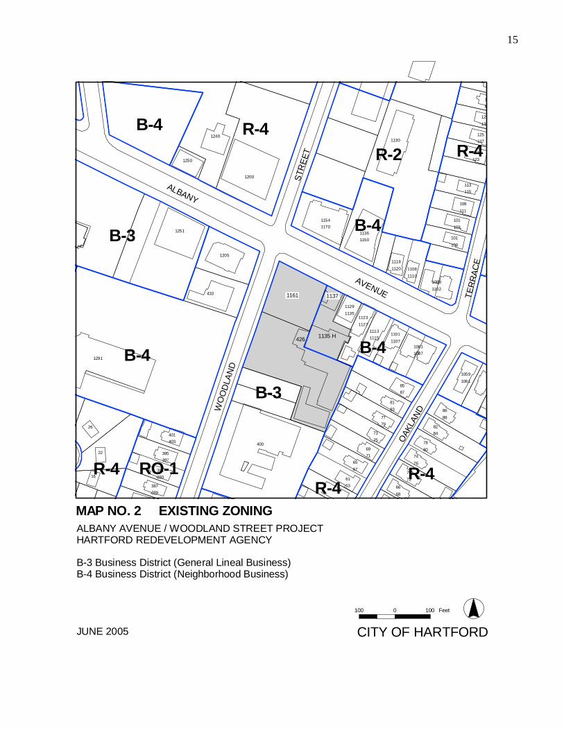
15
CITY OF HARTFORD
B-4
R-4
B-3
R-2
R-4R-4
B-3
R-4
R-4
B-4
B-4
B-4
RO-1TE
RR
ACE
STR
EET
OAK
LAND
ALBANY
WO
OD
LAN
D
AVENUE
1
1130
129
1240 125
121
1250
113
109
1154
1251 1136
101
101
12051118
1108
1088
433
1129
1123
11131101
1291
1081
1059
85
81
86
400
77
822673401
7869
3952274
65
70391
6116
66387
1
131
127
123
115
111
1170
1150
103
103
1120
1110
1102
1135
1127
11151107
1097
1061
87
83
8879
8475403
8071
39776
67
72393
63
68389
1161
426 1135 H
1137
1200
100 0 100 Feet
ALBANY AVENUE / WOODLAND STREET PROJECTHARTFORD REDEVELOPMENT AGENCY
B-3 Business District (General Lineal Business)B-4 Business District (Neighborhood Business)
JUNE 2005
MAP NO. 2 EXISTING ZONING
16
TER
RAC
E
STR
EET
OAK
LAND
ALBANY W
OO
DLA
ND
AVENUE
1
1130
129
1240 125
121
1250
113
109
1154
1251 1136
101
101
12051118
1108
1088
433
1129
1123
11131101
1291
1081
1059
85
81
86
400
77
822673401
7869
3952274
65
70391
6116
66387
1
131
127
123
115
111
1170
1150
103
103
1120
1110
1102
1135
1127
11151107
1097
1061
87
83
8879
8475403
8071
39776
67
72393
63
68389
1161
426 1135 H
1137
1200
ALBANY AVENUE / WOODLAND STREET PROJECTHARTFORD REDEVELOPMENT AGENCY
JUNE 2005
100 0 100 Feet
CITY OF HARTFORD
AUTO-REPAIR
RETAIL
VACANT LAND
WAREHOUSE
MAP NO. 3 EXISTING LAND USE
17
4
3
2
1
TER
RAC
E
STR
EET
OAK
LAND
ALBANY W
OO
DLA
ND
AVENUE
1
1130
129
1240 125
121
1250
113
109
1154
1251 1136
101
101
12051118
1108
1088
433
1129
1123
11131101
1291
1081
1059
85
81
86
400
77
822673401
7869
3952274
65
70391
6116
66387
1
131
127
123
115
111
1170
1150
103
103
1120
1110
1102
1135
1127
11151107
1097
1061
87
83
8879
8475403
8071
39776
67
72393
63
68389
1161
426 1135 H
1137
"!1
1200
100 0 100 Feet
CITY OF HARTFORD
BLOCK
PARCEL
ALBANY AVENUE / WOODLAND STREET PROJECTHARTFORD REDEVELOPMENT AGENCY
JUNE 2005
LOCATION
1135H ALBANY AV
1137 ALBANY AV
1161 ALBANY AV
0426 WOODLAND ST
OWNER
HARVEY LEVITT / ARLINE LEVITT
NOEL F MCGREGOR JR.
MOBIL OIL CORP
WOODLAND MOVING & WAREHOUSE INC
TO BEACQUIRED
YES
YES
YES
PARCEL NO.
1-1
1-2
1-3
1-4
YES
AREA
11,932 SF
2,614 SF
21,095 SF
47,480 SF
MAP NO. 4 PROPERTY MAP
18
TER
RAC
E
STR
EET
OAK
LAND
ALBANY
WO
OD
LAN
D
AVENUE
1
1130
129
1240 125
121
1250
113
109
1154
1251 1136
101
101
12051118
1108
1088
433
1129
1123
11131101
1291
1081
1059
85
81
86
400
77
822673401
7869
3952274
65
70391
6116
66387
1
131
127
123
115
111
1170
1150
103
103
1120
1110
1102
1135
1127
11151107
1097
1061
87
83
8879
8475403
8071
39776
67
72393
63
68389
1161
426 1135 H
1137
B-4
1200
B-4
ALBANY AVENUE / WOODLAND STREET PROJECTHARTFORD REDEVELOPMENT AGENCY
NEIGHBORHOOD BUSINESS
JUNE 2005 CITY OF HARTFORD
100 0 100 Feet
MAP NO. 5 PROPOSED LAND USE AND ZONING
19
A
TER
RAC
E
STR
EET
OAK
LAND
ALBANY W
OO
DLA
ND
AVENUE
1
1130
129
1240 125
121
1250
113
109
1154
1251 1136
101
101
12051118
1108
1088
433
1129
1123
11131101
1291
1081
1059
85
81
86
400
77
822673401
7869
3952274
65
70391
6116
66387
1
131
127
123
115
111
1170
1150
103
103
1120
1110
1102
1135
1127
11151107
1097
1061
87
83
8879
8475403
8071
39776
67
72393
63
68389
1161
426 1135 H
1137
1200
A/D
A/D
A/D
A/D
100 0 100 Feet
CITY OF HARTFORD
WOODLAND STREET / ALBANY AVENUE PROJECTHARTFORD REDEVELOPMENT AGENCY
JUNE 2005
A ACQUIRE
D DEMOLISH
MAP NO. 6 PROPOSED ACTIVITY