Recreation—Bristol Bay Drainages...Recreation—Bristol Bay Drainages September 22, 2011 25-1 25....
6
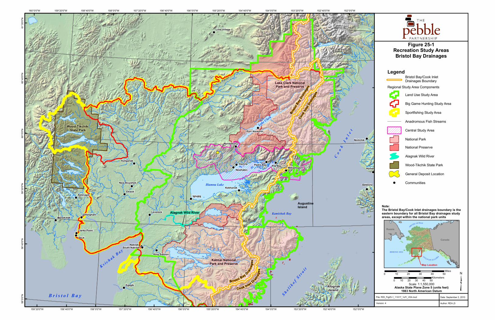
Recreation—Bristol Bay Drainages September 22, 2011 25-1 25. RECREATION 25.1 Introduction The recreation study inventoried, described, quantified, and mapped the outdoor recreational resources and activities in the Bristol Bay drainages study areas (Figure 25-1). The study objectives were as follows: • Describe the location, use, and management status of important recreational resources in the study areas. • Describe, quantify, and map the location of recreational activities. • Estimate the economic contribution of recreation to the economy in the study areas. A regional study area and a central study area were defined in the Bristol Bay drainages for the recreation baseline study (Figure 25-1). The regional study area comprises three overlapping study areas: land use, big game hunting, and sportfishing. The regional study area was flexibly defined to fit the geographic databases for different recreational resources, activities, and management regimes. The central study area encompasses the local drainage areas in the immediate vicinity of the Pebble Deposit and along the northeastern extent of Iliamna Lake (the central study area coincides with the mine study area, transportation-corridor study area, and Iliamna Lake study area depicted on Figure 1-4 in Chapter 1). The study area boundaries for land use, big game hunting, and sportfishing were defined as follows: • The land use study area encompasses about 22,526 square miles. Its boundary is based on the State of Alaska’s 2005 Bristol Bay Area Plan for State Lands (ADNR, 2005a) and Nushagak and Mulchatna Rivers Recreation Management Plan (ADNR, 2005b), and the boundaries of the Katmai and Lake Clark national parks and preserves. • The sportfishing study area encompasses an estimated 26,233 square miles. Its boundary is based on the Alaska Department of Fish and Game’s fishery management areas. • The big game hunting study area encompasses an estimated 23,283 square miles. Its boundary is based on sub-units of the Alaska Department of Fish and Game’s game management units 9 and 17. The baseline description draws on state and federal land use plans and resource management documents, published and online reports, and documents and unpublished data records, with additional information from extensive Internet searches and other unpublished sources. The National Park Service does not have detailed management plans for the national parks and preserves in the regional study area; much information on the parks and preserves came from National Park Service websites and publications. Because some recreational uses of state and federal lands do not require registration or permits, such uses are not systematically counted and may go unnoticed. Routine outdoor recreation of local residents goes mostly
Transcript of Recreation—Bristol Bay Drainages...Recreation—Bristol Bay Drainages September 22, 2011 25-1 25....
Recreation—Bristol Bay Drainages
September 22, 2011 25-1
25. RECREATION
25.1 Introduction The recreation study inventoried, described, quantified, and mapped the outdoor recreational resources and activities in the Bristol Bay drainages study areas (Figure 25-1). The study objectives were as follows:
• Describe the location, use, and management status of important recreational resources in the study areas.
• Describe, quantify, and map the location of recreational activities.
• Estimate the economic contribution of recreation to the economy in the study areas.
A regional study area and a central study area were defined in the Bristol Bay drainages for the recreation baseline study (Figure 25-1). The regional study area comprises three overlapping study areas: land use, big game hunting, and sportfishing. The regional study area was flexibly defined to fit the geographic databases for different recreational resources, activities, and management regimes. The central study area encompasses the local drainage areas in the immediate vicinity of the Pebble Deposit and along the northeastern extent of Iliamna Lake (the central study area coincides with the mine study area, transportation-corridor study area, and Iliamna Lake study area depicted on Figure 1-4 in Chapter 1). The study area boundaries for land use, big game hunting, and sportfishing were defined as follows:
• The land use study area encompasses about 22,526 square miles. Its boundary is based on the State of Alaska’s 2005 Bristol Bay Area Plan for State Lands (ADNR, 2005a) and Nushagak and Mulchatna Rivers Recreation Management Plan (ADNR, 2005b), and the boundaries of the Katmai and Lake Clark national parks and preserves.
• The sportfishing study area encompasses an estimated 26,233 square miles. Its boundary is based on the Alaska Department of Fish and Game’s fishery management areas.
• The big game hunting study area encompasses an estimated 23,283 square miles. Its boundary is based on sub-units of the Alaska Department of Fish and Game’s game management units 9 and 17.
The baseline description draws on state and federal land use plans and resource management documents, published and online reports, and documents and unpublished data records, with additional information from extensive Internet searches and other unpublished sources. The National Park Service does not have detailed management plans for the national parks and preserves in the regional study area; much information on the parks and preserves came from National Park Service websites and publications. Because some recreational uses of state and federal lands do not require registration or permits, such uses are not systematically counted and may go unnoticed. Routine outdoor recreation of local residents goes mostly
Pebble Project Environmental Baseline Studies, 2004-2008, Technical Summary
25-2 September 22, 2011
undocumented. Unless otherwise noted, sportfishing data are from 1999 through 2005 and hunting data are from 2000 through 2005.
25.2 Results and Discussion The regional study area is sparsely populated and mostly wilderness or near-wilderness. The state and federal governments are the largest landowners. Principal uses of the region’s resources are subsistence and recreation. Approximately 57 percent of the land use study area is managed primarily for recreation, including three national park units (totaling 11,697 square miles) and 1,248 square miles of state lands. Residents use the area for recreation, but recreational visitors are more numerous. Recreation and related services are important contributors to some local economies.
The Bristol Bay Area Plan (ADNR, 2005a) identifies state lands with high public recreational value based on a comparative analysis of recreational resources and uses. The most common recreational uses in the plan are sportfishing, big game hunting, camping, river and water sports, wildlife viewing, and nature photography. Noteworthy wildlife includes caribou, moose, and brown bears. Five planning regions are within the land use study area. The Nushagak and Mulchatna Rivers Recreation Management Plan (ADNR, 2005b) complements and elaborates on the Bristol Bay Area Plan. It identifies 29 public-use sites on state lands in the land use study area; all are remote campsites or small aircraft landing areas. The Pebble Deposit and transportation-corridor study area are not designated for recreation. The state has designated a Lower Talarik Creek Special Use Area for recreation and preservation of the rainbow trout fishery in Lower Talarik Creek.
The National Park Service units in the regional study area are the Lake Clark and Katmai national parks and preserves and the Alagnak Wild River. The national parks and preserves include substantial areas designated as federal wilderness. The parks are closed to hunting; the preserves and the Alagnak Wild River are open to hunting. Sportfishing is allowed throughout.
Lake Clark National Park and Preserve encompasses about 4 million acres; Native corporations own portions of the land within the boundaries. Small planes, floatplanes, or boats are the main means of access. Backpacking trips, hiking, rafting trips, and wildlife viewing are popular. In 2006, the National Park Service reported 5,320 recreational visits and 3,939 recreational visitor days (of 12 hours or more). In the years 2000 through 2006, the numbers of visitors averaged 5,051 visitors per year, mostly from June through September.
Katmai National Park and Preserve encompasses about 4.1 million acres; approximately 72,000 of those acres are not federally owned. Visitor access is by floatplane or small plane. There is one improved camping area in the park, near Brooks Camp (with 18 campsites), and only a few short improved trails. Three lodges are operated under National Park Services concession, and there are four remote lodges on private inholdings. Recreational attractions include wildlife viewing, sportfishing, sightseeing, flight-seeing, nature photography, canoeing, five active volcanoes, and remote wilderness land and waters. Brooks Camp, for brown bear viewing, and the overlook for the Valley of Ten Thousand Smokes are by far the most popular visitor destinations in the park. Data report 68,630 recreational visits in 2006, with 7,430 overnight
Recreation—Bristol Bay Drainages
September 22, 2011 25-3
stays. Data show a decline in recreational visits from 2000 through 2005, but an increase in 2006. Ninety-eight percent of all visits occurred during June through September.
The Alagnak Wild River is a 67-mile-long river corridor that encompasses 30,665 acres. Primary access is by floatplane. Five remote, private recreational lodges are situated along the corridor. The Alagnak River is the most productive fly-in sport fishery in southwest Alaska, and the Alagnak Wild River corridor is one of the region’s most popular destinations. Other recreational activities include river rafting, wildlife viewing, and backcountry camping. There are no published visitor statistics for the Alagnak Wild River and, therefore, no estimates of economic impacts.
The National Park Service requires commercial operators in park units to obtain a commercial use authorization for each type of service offered in the parks. The most common commercial use authorizations in the parks in the regional study area are for sportfishing (133), bear viewing (120), air taxis (81), and photography guides (68).
It is estimated that nonlocal visitors to Lake Clark National Park and Preserve spent $352,000 in 2006, generating an estimated seven jobs and $141,000 in personal income. The National Park Service payroll at Lake Clark National Park and Preserve supported an additional 37 jobs and $2,202,000 in personal income. Non-local visitors to Katmai National Park and Preserve spent an estimated $3,316,000, generating 66 jobs and $1,151,000 in personal income. The payroll for Katmai National Park and Preserve supported an additional 56 jobs and $2,943,000 in personal income.
The Bureau of Land Management administers other federal lands in the regional study area. The State of Alaska manages fish and wildlife resources on those lands.
Across the regional study area, sportfishing supports a recreation-based economy that includes air taxi services, lodges, guides, outfitters and suppliers, and other businesses. The sport fishery is primarily a catch-and-release freshwater fishery. In a typical year, it is estimated that more than 15,000 sportfishers make about 35,000 trips to the region, spend about 70,000 days fishing, and catch 400,000 fish. In 2004, 88 percent of sportfishers came from outside Alaska. Access is by small plane or riverboat.
Freshwater sportfishing accounted for about 90 percent of all sportfishing in 1999 through 2005. In 2004, more than 90 percent of the catch was released. The primary species caught in the sportfishing study area were rainbow trout (36 percent), grayling (14 percent), king salmon (almost 13 percent), sockeye salmon (more than 10 percent), Dolly Varden (9 percent), and coho salmon (6 percent).
The central study area accounted for 8.4 percent of angler days and 7.4 percent of the catch in the regional study area. About 16 percent of the total catch in the central study area was retained as harvest. The most frequently caught species in the central study area, by annual average, were sockeye salmon (9,127), rainbow trout (7,197), grayling (6,056), Dolly Varden (3,987), coho salmon (848), and king salmon (412). Analysis of data indicated a decline in angler days and total catch between 1999 and 2005.
Pebble Project Environmental Baseline Studies, 2004-2008, Technical Summary
25-4 September 22, 2011
The type of hunting relevant to this study is the general-season hunt, which is open to most people and includes some subsistence hunting. Caribou, moose, and brown bear are the main big game species hunted across the hunting study area. There was also some hunting for black bear, Dall sheep, and wolves. Generally, state lands are open for hunting as allowed by regulation, but national parks, though not the preserves, and other parts of the study area are wholly or partly closed to hunting. Overall, the data over the past decade showed a steep decline in caribou herd size, hunting, and harvest in the regional and central study areas, and a modest drop in moose hunting. Brown bear hunting was stable.
The caribou harvest from the two primary caribou herds (Mulchatna and Alaska Peninsula North, both of which are declining) fell from 9,684 in 2000 to 2,179 in 2005, not including harvest from restricted permit hunts. The annual harvest in the hunting study area ranged from a high of 2,426 in 1999 to only 312 in 2006. The average number of caribou hunters in the hunting study area fell from 3,615 in 2000 to 1,936 in 2005, and hunter days dropped by 55 percent. In 2005, two-thirds of caribou hunters in the hunting study area were Alaska residents. Resident hunters were more successful than nonresident hunters—75 percent of resident hunters harvested a caribou. Hunters accessed the area mostly by plane and spent an average of 5.3 days per trip. Between July 1, 2004 and June 30, 2006, most of the Mulchatna Herd harvest occurred in August and September; the Alaska Peninsula North Herd harvest was spread more evenly.
The hunting study area yielded an annual average harvest of 285 moose during the years 2000 through 2005. The total annual moose harvest for the hunting study area dropped by almost half in that period, and the central study area showed a similar trend. In the hunting study area in 2005, more moose hunters were residents (56 percent) than were nonresidents (43 percent). The rate of success for both was about 29 percent. Most moose hunters (64 percent) in 2005 accessed the hunt area by airplane. From 2000 through 2005, more than 90 percent of the annual harvest occurred in September.
The brown bear harvest in the hunting study area during 2000 through 2005 averaged 111 bears annually. Year-to-year harvest fluctuations stemmed largely from alternate-year hunting restrictions.
An inventory of 73 recreational lodges in the sportfishing study area was compiled for 2006 through 2008. The inventory does not include unimproved, transient camp facilities, but does include lodges that may be closed or used for other purposes in any given season. Lodges typically are owner-operated.
Lodges are primarily geared to the sportfishing season (June through September), but some cater to big game hunters. The rate for a sportfishing trip may range from $3,500 to $8,000 or more per person, depending in part on the length of stay and the services provided. High-end trips typically include guide services, flights to more remote areas, gear, fish packaging, accommodations, and food. Several lodges maintain planes and boats to provide transportation services. Low-end lodges typically offer simpler facilities and fewer services.
Most lodges are owned by nonresidents of the region. The lodges employ mostly nonlocal seasonal workers and import most of their fuel, foodstuffs, and other supplies. As a result, the lodges’ contribution to resident earnings and local economies is limited.
Recreation—Bristol Bay Drainages
September 22, 2011 25-5
25.3 References Alaska Department of Natural Resources (ADNR). 2005a. Bristol Bay Area Plan for State
Lands. Division of Mining, Land and Water, Anchorage, AK.
———. 2005b. Nushagak and Mulchatna Rivers Recreation Management Plan. Division of Mining, Land and Water, Anchorage, AK.
!
!
!
!
!
!
!
!
!
!
!
!
!
!
!
!
!
!
!
!
!
!
!
!
! !
!
!
!
!
!
!
!
Ekuk
Kenai
Homer
Ekwok
Aniak
Kodiak
Tyonek
Togiak
Egegik
Iliamna
Igiugig
Seldovia
Pile Bay
Levelock
Kokhanok
Sleetmute
NondaltonNinilchik
Manokotak
Koliganek
Aleknagik
Port Lions
Dillingham
King Salmon
Williamsport
New Stuyahok
Lime Village
Kashiagamiut
Clarks Point
Port Alsworth
Naknek
Newhalen
South Naknek
Pedro Bay
K v i c h a k B a y
Iliamna Lake
S h e l i ko f S
t r a i t
Co o k I
n l et
Lake Clark
B r i s t o l B a y
Augustine Island
AfognakIsland
Kamishak Bay
Katmai NationalPark and Preserve
Lake Clark NationalPark and Preserve
Wood-Tikchik State Park
Alagnak Wild River
152°0'0"W
152°0'0"W
152°40'0"W
152°40'0"W
153°20'0"W
153°20'0"W
154°0'0"W
154°0'0"W
154°40'0"W
154°40'0"W
155°20'0"W
155°20'0"W
156°0'0"W
156°0'0"W
156°40'0"W
156°40'0"W
157°20'0"W
157°20'0"W
158°0'0"W
158°0'0"W
158°40'0"W
158°40'0"W
159°20'0"W
159°20'0"W160°0'0"W
61°20
'0"N
60°40
'0"N
60°0'
0"N59
°20'0"
N58
°40'0"
N58
°0'0"N
LegendBristol Bay/Cook Inlet Drainages Boundary
Regional Study Area ComponentsLand Use Study Area
Big Game Hunting Study Area
Sportfishing Study Area
Anadromous Fish Streams
Central Study Area
National ParkNational Preserve
Alagnak Wild River
Wood-Tikchik State Park
General Deposit Location
! Communities
0 10 20 30 40 50Kilometers ³
0 10 20 30 40 50Miles
1:1,550,000ScaleAlaska State Plane Zone 5 (units feet)
1983 North American DatumDate: September 2, 2010
Author: RDI-LS
Figure 25-1Recreation Study AreasBristol Bay Drainages
Canada
ARCTIC OCEAN
GUL F OF AL A SKA
Russia
BERING SEA
Map Location
File: RDI_Fig25-1_11X17_1of1_V04.mxd
Version: 4
Bristol Bay D raina
ges
Cook Inlet Draina
ges
Bristol
Bay Dr
ainag
es
Cook
Inlet
Drain
ages
Note:The Bristol Bay/Cook Inlet drainages boundary is theeastern boundary for all Bristol Bay drainages studyareas, except within the national park units