Records in Karnataka: Computerized Land Registration System
31
Urban Property Ownership Records in Karnataka: Computerized Land Registration System for Urban Properties S Manasi, K C Smitha, R G Nadadur, N Sivanna, P G Chengappa
Transcript of Records in Karnataka: Computerized Land Registration System

Urban Property OwnershipRecords in Karnataka:Computerized LandRegistration System forUrban Properties
S Manasi, K C Smitha, R G Nadadur,N Sivanna, P G Chengappa

ISBN 978-81-7791-164-0
© 2013, Copyright ReservedThe Institute for Social and Economic Change,Bangalore
Institute for Social and Economic Change (ISEC) is engaged in interdisciplinary researchin analytical and applied areas of the social sciences, encompassing diverse aspects ofdevelopment. ISEC works with central, state and local governments as well as internationalagencies by undertaking systematic studies of resource potential, identifying factorsinfluencing growth and examining measures for reducing poverty. The thrust areas ofresearch include state and local economic policies, issues relating to sociological anddemographic transition, environmental issues and fiscal, administrative and politicaldecentralization and governance. It pursues fruitful contacts with other institutions andscholars devoted to social science research through collaborative research programmes,seminars, etc.
The Working Paper Series provides an opportunity for ISEC faculty, visiting fellows andPhD scholars to discuss their ideas and research work before publication and to getfeedback from their peer group. Papers selected for publication in the series presentempirical analyses and generally deal with wider issues of public policy at a sectoral,regional or national level. These working papers undergo review but typically do notpresent final research results, and constitute works in progress.

URBAN PROPERTY OWNERSHIP RECORDS (UPOR) IN KARNATAKA
COMPUTERIZED LAND REGISTRATION SYSTEM FOR URBAN PROPERTIES1
S Manasi, K C Smitha, R G Nadadur, N Sivanna, P G Chengappa∗
Abstract
Effective land governance mechanism has been long overdue initiative in India. The challenges
posed by the recent global developments, especially rapid urbanization, unregulated migration to
urban centres, ineffective land management practices, institutional fragmentation, decentralized
reforms and lacuna in the legal system to guarantee land titles, etc. have increased the
complexity of land administration in the country. It is with the intention of addressing these
problems that the UPOR has been initiated in Karnataka. It is expected that UPOR will promote
efficiency in service delivery and enable citizen interface with the digital management of land
records throughout the state.
Background
The smooth functioning of an economic system requires accurate and efficient maintenance of the land
records in order to authenticate land related transactions and eliminate spurious land deals. Increased
urbanization has created complex land transaction-related issues. Some of the problems associated with
urban land transactions include unnatural increase in the demand for urban property, creation of fake
documents, ‘benami’ and fraudulent land transactions, etc., and most of these maladies can be traced
to insufficient checks/control at various official levels for monitoring irregularities in land transactions.
Putting in place appropriate mechanisms to check these ills will go a long way in reducing public
insecurity. A study conducted by Mckinsey2 in India has shown that India loses 1.3 percent of its
potential growth due to poorly maintained land records. Much of the registration process in India does
not result in valid ownership titles. Hence, more than 70 per cent of all legal disputes are regarding
land. The paper throws light on the initiation Urban Property Ownership Records (UPOR), in Karnataka
State, which is a computerized process of land title registration system for urban areas meant to ensure
authentication of property titles. The paper is divided into three sections: Section one provides historical
perspective on the concept of city survey in Karnataka and recent development in urban centres of
Karnataka. Section two gives details regarding the UPOR initiative and the stages of its implementation.
Finally, Section three presents the different set of stakeholders and the complexities involved in the
implementation of this programme.
1 This paper is based on a larger study supported by The World Bank, USA, carried out by the Centre for Ecological
Economics and Natural Resources, Institute for Social and Economic Change, Bangalore, India in 2011 and 2012.
∗ S Manasi is Associate Professor, CRUA; K C Smitha is Research Associate, CEENR; N Sivanna is Adjunct Professor,
R K Hegde Chair; P G Chengappa is ICAR National Professor, ISEC, Bangalore and R G Nadadur is Retired from
Indian Administrative Service, Govt of Karnataka, and Chief Operating Officer of Gurudev Sri Sri Ravishankar’s
Vidya Mandir Trust, Bangalore. 2 Mckinsey (2001). India the Growth Imperative, Washington DC: Mckinsey Global Institute

2
Section I
Concept of City Survey - A Historical Perspective Historically, the first formal and recorded urban mapping or city survey in the country was introduced
during the year 1900-10. Such a measurement was first carried out in the Bombay Presidency and it
later spread to other major cities so that, by 1918, the system had became a full-fledged one. The
Karnataka Survey Settlement and Land Records (KSSLR) Department is one of oldest survey
departments established under the Bombay Revenue Act and Karnataka Land Revenue Act (KLR Act,
1964). At present, urban mapping exists in 48 urban centres of Karnataka, even though the records are
not fully updated. Across 42 sectors of Belgaum, it has been completed by continuing the system that
prevailed in the Bombay Province. The city survey concept was introduced in 6 more districts of
Karnataka, between 1969 and 1975. These districts are Bellary, Gulbarga, Kolar Gold Fields (in Kolar
district), Mysore, Bangalore and Davangere. As many as 112 villages of Belgaum had been notified for
mapping and measurement much earlier to 1969. Similarly, 137 sq. kms of Bangalore core city was
measured and mapped, barring new extensions and fringe areas. As per the available records, in
Karnataka, survey was carried out during different periods as described below -
Table 1: Survey Carried during Different Periods
Sl.No. Survey in Different Periods
1 Original Survey carried out between 1863 and 1890. All the documents prepared during
original survey are in modi Marathi language.
2 Re-survey carried out between 1900 to1920.
3 Hissa survey carried out between 1926 and 1940.
4 Second Re-classification carried out between 1955 to 1966
Source: The Survey, Settlement and Land Records Department, Government of Karnataka (GOK).
Though there has been a manifold increase in property rates in urban India in the past few
years, urban land management practices have not witnessed commensurate up-dating and still remain
unplanned and unorganized. This has been further accentuated by the rise in the middle class
population, large scale migration to cities of south Karnataka particularly to Bangalore, and rise in
income levels of the educated and employed middle class in cities. Hence, the need for a well
maintained land record system for urban areas cannot be over emphasized, particularly in the context
of soaring land market prices and a competitive urban economy that contributes a large share of the
gross domestic product (GDP).
In the light of a very significant increase in disposable incomes, the property transactions also
have increased substantially as evidenced by the spurt in the number of property registrations especially
in Bangalore in the recent years. Moreover, in the absence of authentic property documents, there is a
misconception among the urban citizens that the municipal ‘Khata’ is the legal property document
indicating the title status. This apart, most of them do not register their property transactions with the
3
authorities concerned for many years unless it is a sale or partition of the property. . Most people are
not aware that the sale deed and ‘Khata’ are not considered legally valid and they do not guarantee
title/ownership of a property. These documents serve as simple proxies for land title. . A sub-registrar
authenticates only transactions, not titles.
Recent Developments in Urban Centres of Karnataka In recent years, though the state of Karnataka has experienced a slower growth rate, the state’s GSDP
(Gross State Domestic Product) is estimated to grow at 6.4 per cent (according to the Economic Survey
of Karnataka) in the year 2011-12 and reach Rs 2,97,964 Crore as against Rs 2,79,932 Crore in 2010-
11. This can be attributed to the growth in manufacturing (4.1 per cent) and service sectors (10.6 in
2011-12)3. Manifold increase in public sector investment followed by private sector investment as a
result of liberalization policies and urban sector reforms4 since two decades it has substantially impacted
the land rights profile of urban citizens. Given the impact of such macro policies, there is a need for
proper implementation of Karnataka’s urban land legislation and regulations. This need is made more
urgent by a number of recent developments such as rapid urbanization, poor urban land management,
increased private investment, unprecedented demand for urban land, reforms brought in like
decentralization lacuna in existing legal system, etc.
1. Rapid Urbanization
The process of rapid urbanization5 in Indian cities has shaped the pattern of economic growth; the
massive migration6 from rural areas to urban centres commenced in the decade 1990-2000 continues
till date. As a result, cities have become major centres of industrial development and have contributed
to a boom in construction and service sector industries. The expansion of these sectors has created
enormous job and investment opportunities and urban sprawl. By 2025, 50 per cent of Karnataka’s7
population (40 million) is expected to live in urban areas. However, existing urban planning instruments
are inadequate to deal with the ongoing haphazard development, and may lead to serious regional
imbalance in the days to come. In addition, much of official attention and resources are being bestowed
on other large cities in Karnataka than Bangalore, so there is less ‘Bangalore-centric’ development.
Besides, the rate of urban poverty is more than rural poverty in the state. Urban poverty constitutes
3 The Businessline, Hindu (2012). Karnataka's economic growth to slow down to 6.4% in 2011-12, March 20th.
www.thehindubusinessline.com 4 Urban sector reforms are initiated by government of India through JNNURM Project (2005)-Jawaharlal Nehru
Urban Renewal Mission. The mission insists on optional land reforms for both rural and urban areas through
computerisation. 5 Nearly 28 per cent of total population live in urban areas in India (UDP 2009:3). 6 Migration towards the higher order of urban centres has the effect of 66 per cent of the urban population
concentrated in 23 Class I cities. Mysore and Hubli-Dharwad constitute emerging metropolitan cities in Karnataka
(UDP 2009:3). 7 Urban settlement structure in Karnataka is highly dense with 67 per cent of urban population living in 24 cities
(UDP 2009: 5).

4
32.6 per cent in Karnataka which is high compared to the other states. The fundamental need is to
accelerate orderly urban development in towns and cities other than Bangalore, to act as counter-
magnets to attract migrants as also to regulate the allocation and use of land in a fair and equitable
manner in urban areas.
2. Private Investment and Demand for Urban Land
Demand for urban land is the result of several factors like macro level liberalization policies in promoting
private investment in the delivery of basic services, development of service sector in the form of
establishing IT (Information Technology)/BT (Biotechnology) industries, rural-urban divide resulting in
mass exodus of migrants from rural areas to cities in search of job opportunities and opportunities in
the mining sector (iron ore) in districts like Bellary region in Karnataka. As a result, great demand for
urban land is created by both informal communities and investors have given rise to conversion of land
from agricultural land to non-agricultural uses. As this is most often done without clear land titles, such
dubious land transactions and land litigations have changed the very concept of land use (Wadhwa
2002). This is further aggravated by the absence of updated land records, which often lead to time and
cost overruns in several development projects. The state finds itself unable to protect its own land
rights as well as that of its citizens, from large scale encroachments, court litigations and land mafia.
The lacuna in the existing legal framework concerning ownership of land is far too apparent. Hence, the
need for a system of state guarantee for land title or property rights.
3. Decentralized Reforms
Decentralized reforms were ushered through 73rd and 74th constitutional amendments. This has
increased the number of players in the land sector with more opportunities to access services, and has
necessitated a comprehensive land policy. Decentralized governance has transferred authority to local
governments to mobilize resources besides managing land and delivering titles. Urban land constitutes a
very important asset of the local government, generating significant financial resources through land
management and taxation (Burns 2007). Local land management practices have assumed greater
significance through development process in terms of facilitating infrastructure, access to basic
amenities and facilitating sustainable natural resource management. At the same time, danger exists in
terms of local institutional overlapping, and conflicting agendas that increase the cost and, thus,
harmfully affect long-term development. Emergence of decentralized local governance has facilitated
greater development in land administration.
4. Urban Land Management Practices
Effective urban land management is critical to urban development. The absence of well planned urban
land management results in spiraling land prices, speculation and inflation, and growth of informal
settlements that adversely impact social welfare and overall development. Inadequate land
management framework in urban areas also results in violation of land use regulations and in
encroachments (UDP 2009: 9; Dowall and Clark 1996: 5). Typically, urban land regulations are

5
influenced by zoning, regulated densities, building by-laws, master plan and comprehensive city
development plans.
Violation of urban land use regulations is due to lack of valid cadastral, registration, and
approved records; it results in haphazard and unconstrained land use and seriously impact the efficiency
of the city governance. Further, increase in the volume of urban land transactions due to rapid
industrialization, and changes in land use pattern due to urbanization, have further complicated the
formal process of land registration. The situation is aggravated by informal settlements such as slums8
and encroachments on urban land. Lack of formal security of land tenure causing disjunction in planning
if the informal settlements need to be recognized in the planning instruments (Ramanathan 2009).
Under such developments, the city administration has less control over land regulation, allocation and
management.
5. Lacuna in Legal System to Guarantee Land Titles
Time and again, uncoordinated, disintegrated and outdated land related legislation has lead to critical
situations in many developing countries (Burns 2007). Lack of effective implementation, and
predominance of deeds9 system over title registration system, in the existing land transfer system in
India, mean that the title is not backed by any state guarantee (Wadhwa 2002). There are instances of
land related conflicts leading to court litigation involving social cost and disrupting societal harmony.
Though the constitution of India had originally guaranteed right to property as a fundamental
right, by the 44th constitutional amendment in 1978, the right to property was reduced to the status of
legal right and is no longer a fundamental right with constitutional remedies. In Karnataka, land use is
regulated by Karnataka Land Reforms Act of 1964 and Indian Registration Act of 1908. While these acts
envisage compulsory registration of sale of land, they do not provide for registration of title, but only
result in registration of a deed of transaction. Registration process merely acts as a fiscal instrument of
the state to collect a ‘fee’, but does not provide statutory guarantee10 to the land title. Further, Section
18 of the Registration Act does not stipulate compulsory registration of all land-related transactions11
(Wadhwa 1989, Ramanathan 2009). As a result, existing legal titles do not reflect any changes resulting
in succession or transfer, or more broadly the customary rights recognized in the community (like
slums/informal settlements), and these differences add to the existing complexities in urban land
dynamics.
8 Nearly 7.8 per cent of the urban population lives in slums in 35 towns of Karnataka state. According to the NSSO,
58th round (2002), the number of slums in Karnataka is estimated to be 1983 with 4,83,828 households (UDP
2009: 10). 9 A deed does not in itself prove title; it is merely a record of an isolated transaction. 10 State laws does not entertain any suit against the state government or any officer of the state government in
respect of a claim to have any entry made in any record or register maintained by the government or to have any
entry omitted or amended (Wadhwa 2002). 11 Such as state acquisition of land, court decrees, land orders, partitions, mortgages, agreements to sell the land
etc.

6
Section II
Initiation of ‘Urban Property Ownership Records’ (UPOR) in
Karnataka Urban local bodies (ULBs)12 in Karnataka have been maintaining property tax details through a property
tax record called “Khata13”. ‘Khata’ document is presumed to be a property ownership record. Moreover,
as ULBs are not authorized to create and maintain property ownership records, they maintain only
“Khatas” for the purpose of tax collection from urban citizens, and Khata is not a Record of Rights (RoR)
issued in respect of revenue or agricultural land. Therefore, having Khata per se does not indicate legal
status.
The existing city survey system is now being extended to all the major cities of the state as the
Urban Property Ownership Rights (UPOR). Initially, pilot projects are being carried out in the cities of
Mysore, Hubli-Dharwad, Shimoga, Mangalore and Bellary in order to cover all the municipal and urban
properties in stages, in accordance with the provisions of KLR Act. The Act requires the creation of
property ownership cards for areas with more than 5000 population.
The purpose of property ownership records is to improve liquidity and increase transactions
while enabling the property owner to readily monetize his assets. In addition, the creation of urban
property record system aims at reducing cost and time involved in land related litigations. Further the
goal of the UPOR is to enhance and promote efficiency in service delivery while promoting citizen
interface with the digitized management of land records throughout the state.
The UPOR is also intended to ensure transparency in land administration procedures, simplify
the process of registration, provide greater access to information, centralize land records data and
thereby improve accountability. It is expected that UPOR will result in the elimination of corruption and
middlemen in the realm and promote good governance. One of the primary aims of UPOR is to create
an approved land record system of documents by a statutory authority in urban areas in order to enable
the other stakeholders to make use of this database.
The state government is also examining a proposal to make the property card mandatory for
sale and purchase of property, home loans and other land related transactions. The government
believes that the card will help individuals and organizations in buying and selling land, as records will
be accurate and appear both on the map and in the ownership data. The property record created
through this project will be evidence of property ownership for all regulatory and legal purposes.
Property record over the years is expected to be updated regularly and will, therefore be current
relevancy.
12 There are 213 ULBs in Karnataka varying in size based on population from 10,000 to almost a million. Bangalore
city, the state capital, has almost reached 9 million. 13 Khata means an account maintained by city municipal council (CMC) for collecting property tax from property
owners and it is not an ownership document.

7
1. Mandates of Survey Settlement and Land Records (SSLR)14
The Survey, Settlement and Land Records Department, Government of Karnataka (GOK), has been
mandated under the Karnataka Land Revenue Act of 1964, and KLR Rules of 1966 to prepare, maintain
and preserve spatial and non-spatial data relating to ownership of land for properties in urban areas of
Karnataka. The specific sections of the KLR Act 1964 governing the implementation of UPOR in
Karnataka include (a) Chapter 1 – Section 1(2) and Section 2(2, 6, 38), and (b) Chapter XIII – All
Sections (148 to 156) popularly known as “City Survey”.
The main objective of city survey is to initiate the process of an accurate survey of private and
government properties (like buildings, houses, roads, playgrounds, parks etc;), generate a survey
sketch including other property related documents in cities and towns and accord a specific and
permanent identification number to each property. This process is mainly related to administrative, legal
and economic aspects of land based transactions. City survey maps are the main source of information
for city planning like roads, road numbers, railway lines, parks, playgrounds, individual and government
properties, and institutional properties with specific numbers and sketch details.
This information in turn is used by other departments like, electricity companies, water supply
department, municipal corporations and ULBs for tax assessment purposes, while police department,
urban land development bodies, census department use it for their developmental planning and
projects. Thus, the survey department renders services like, supply of survey maps and sketches,
certified copies of property details like buildings, lands and property register cards.
It is important and essential, for every land-owner, to have proper and legally acceptable
documents related to property. Without the city survey process, there can be no proper and specific
document related to area, survey numbers, details of owner and mode of acquisition, possession rights
encumbrance etc. As mentioned earlier, ‘Khata’ issued by a Municipality or Corporation for the purpose
of paying revenue tax is considered as property right certificate by citizen but the fact is that it does not
legally constitute a document attesting ownership of property. Property cards that are proposed to be
issued to all land-owners will be ownership records with legal sanction as per section 133 of Karnataka
Land Revenue Act 1964, and would replace the existing records of presumptive ownership. The records
will be maintained in the form of maps and sketches depicting boundaries and the extent of individual
properties and text relating to ownership, land use and other land related particulars.
In order to make the process citizen-friendly, as per the Karnataka Land Revenue (KLR) Act
1964, the Survey, Settlement and Land Records Department (SSLR) introduced Urban Property
Ownership Records (UPOR), a comprehensive framework, for the creation and management of urban
property records in December 2009. The Work Order was issued on 2nd December 2009, while Master
Services Agreement was signed on 11th January 2010.
Although SSLR maintains urban property records in Bangalore, Mysore and 41 other towns of
Karnataka, due to insufficient manpower and financial crunch, the records are not getting updated, on a
regular basis. On the lines of the successful implementation of Bhoomi, in rural Karnataka, the need for
a similar property records system was felt for urban centres also (Mukerji 2011). Form 2013 Property
Card (PC) will become a statutory requirement and would be made mandatory for transactions like bank 14 Based on the extracts from the Concept Note of UPOR.
8
loans or selling property in all urban centres where the records are up-to-date and accessible for official
used.
The UPOR property ownership records are legally authenticated documents, finalized through a
statutory enquiry process as per law including ascertaining the ownership of properties and
measurements, and used as legal and primary references for resolving any kind of legal disputes related
to ownership, location, dimensions and areas of urban properties.
UPOR is being implemented in five cities of Karnataka since December 2009. It is a process of
confirming the presumptive property title and providing a conclusive property title of all “urban
properties” as mandated under the Land Revenue Act and 1964 and Rules 1966. The project aims to
create a comprehensive database, both spatial and non-spatial, of all properties of urban centres in
Karnataka. It is planned to extent UPOR to other cities and towns after the results of these pilot
projects are known and studied.
2. Objectives of UPOR
The main objective of UPOR is to issue ownership title to urban households and the creation of a fresh
data base for urban mapping. It is important to note here that the generation of revenue is not the sole
purpose of urban mapping under UPOR. The sub-objectives of UPOR include:
• Measurement and mapping of all non agricultural lands and urban properties
• Creating and maintaining Record of Rights (RR) for all non agricultural lands.
• The preservation of existing land records by the revenue department.
A robust system of UPOR is created for every property with a view to documenting accurately both
spatial characteristics of properties and record of rights data in respect of (i) land parcels (ii) structures
/buildings (iii) roads etc. This property record will serve as a trusted record for all land related
transactions. The property card created under UPOR would serve as evidence for property ownership
for regulatory and legal purposes. The property card issued will continue to remain valid and will not
become obsolete or inaccurate. All the property record related transactions and services are intended to
be fulfilled through this project (UPOR webpage)15.
3. Outline and Scope of the UPOR16
Under UPOR, property records will be recreated for urban areas under the provisions of Karnataka Land
Revenue Act 1964. UPOR was initiated to create and maintain property ownership records in five urban
bodies within a framework for management of land records in urban centres. Five cities were selected
on a pilot basis - Mangalore, Bellary, Mysore, Hubli-Dharwad and Shimoga. The Revenue Department
has been working on making the land records of the state, both cadastral as well as textual data, more
accurate across cities. Another interesting feature of the project is that UPOR is being implemented
15 UPOR objectives are listed out in City Survey Department-UPOR webpage www.upor.karnataka.gov.in. . 16 UPOR outline and scope are presented in Request for Proposal (2009).

9
through Public-Private-Partnership (PPP) mode, in particular BOOT17. Government of Karnataka has
teamed up with private sector partners in the area of land administration and records. The UPOR
authorities, led by the Deputy Commissioner of the District concerned have set up Citizen Facilitation
Centres for receiving relevant documents from property owners for ascertaining their ownership claims.
The task of creating and maintaining the property records for urban areas involves 4 distinct
steps.
1. Creation of Property records which includes (i) survey and mapping of all properties in the cities,
and (ii) verification of ownership claims.
2. Continuous management and maintenance of property records includes (a) creation of property
records for new extensions of cities (b) Documenting changes in property records in the context of
new constructions, and (c) Updating changes in land use and mutation of property records in case
of sale/partition
3. Operation and Maintenance of service delivery channels through ‘Bangalore One’ centres to deliver
various property record related services to citizens. These service centres are established by the
Survey Department. The above three tasks are performed by the service provider, and finally
4. Creation of IT infrastructure that will enable the storage of property records and delivery of various
property record related services like (i) Title Enquiry; (ii) Certifying Transactions and (iii) Changes in
property records. The IT infrastructure comprises (a) Software application; (b) Various COTS
software products; (c) Servers, Storage and other IT hardware. These activities are carried out by
technical service providers.
The first three tasks are performed by service providers (SP), and while the fourth by Technical
Service Providers (TSP).
4. Benefits of City Survey/ UPOR Property Card
Some of the benefits that are expected to accrue to the owners of properties are
(i) Security for property
(ii) Protection from unauthorized acquisition
(iii) Exact property details and also other relevant survey numbers
(iv) Facilitates seeking of legal assistance from courts in case of disputes
(v) Enables in availing bank loans by submitting the survey documents
(vi) Facilitates access to water and electricity services
(vii) Provides information on transfer/ mutation of properties
(viii) Allotment of a permanent and specific number to each individual property prevents the
occurrence of frauds in the process of buying and leasing of properties
(ix) Helps in obtaining building plan approval
(x) Protection from unauthorized encroachment of Government lands
(xi) Property record over the years will remain current and accurate
17 Build, Own, Operate, and Transfer (BOOT) model followed for the implementation of UPOR

10
5. List of Services ‘Expected to be Delivered’ by UPOR18
The following services are expected to be delivered by the UPOR project.
1. Information Services which includes:
Search for various types of properties and related documents like sale deeds,
History of transactions of various properties post UPOR project;
Various thematic layers of Maps (for example roads, public amenities, government properties
etc), and
Search for the entire city based list of properties based on the parameters of the property
database.
2. Information to owners/power of attorney holder or lessee, bank etc. on transaction initiated in
respect of property.
3. Search and Print (Certified Copies) which includes: (i) Certified copies of ownership record and (ii)
Certified copies of transaction recorded in the UPOR database.
4. Map Services include: (i) Maps of the properties with the adjacent properties mapped, (ii) Maps of
the locality like sector 7 HSR layout and (iii) Division of the city into different squares of 1 km to 1
km and mapping of all properties in the maps.
5. Transaction Services include (i) Transfer of ownership through registration and without registration.
(ii) Charge details consist of (a) Creation of Charge (b) Release of Charge and (c) Reducing charges
on the repayment of the loan by the property owner. (iii) Details on recording of any transactions
include: Power of Attorney, long term lease and (iv) Details on sub-division of property.
6. Survey Management Process for (a) resurvey (b) sub-division and (c) amalgamation cases - these
could include special cases such as (i) the acquisition of land by government for public works (ii)
purchase of 2 adjacent properties by a private individual and the creation of a single
commercial/residential building (d) hudbust-refixation of properties and (e) additional
services/Survey on demand on instructions from courts/agencies and other government
departments.
7. Appeal provision includes handling cases related to courts and court commissions/partitions.
8. Services related to the municipal department include: the Dept of Survey Settlement and Land
Records, by networking with urban development departments and the City Municipal Corporation
(CMC), maintains details on property taxes, accepts applications for building plan permits and grant
permission. While delivering such services through UPOR following services are offered:
Statements of tax dues on property;
retrieval of building plan on the property;
application for building plan permission;
payment of property taxes;
preparation of demand notices for the municipalities;
generation of overdue notice for the municipality;
any change in the land use pattern and
layout approval. 18 Notes collected from RFP (2009: 9-10).

11
6. Implementation of UPOR: Public-Private Partnership Model (PPP)
The public-private-partnership (PPP) model has been followed for the city survey, wherein private
agencies were selected through bidding, and they have to implement the UPOR activities in a phased
manner across five pilot cities (Mysore, Mangalore, Bellary, Hubli-Dharwad and Shimoga) in Karnataka.
The PPP would ensure the UPOR implementation within a fixed time frame, while following business
model of cost maintenance. The initiative of PPP in geospatial industry is considered as the most ideal
model in the context of Karnataka (Geospatialtoday.com)19. However, this model is constantly being
reviewed and re-examined in the light of the experience in the earliest project area, i.e.Mysore. At
present, the PPP (Public-Private Partnership) BOOT (Built-Own-Operate and Transfer) model for urban
mapping is being implemented in 5 cities.
Table 2: List of Selected Service Providers for Five Pilot Cities of Karnataka
for UPOR Implementation
Name of the City Name of the Service Provider
Mysore M/s. SECON Pvt Ltd
Mangalore M/s. CMS Computers Ltd and Navayuga Spatial Technologies Pvt. Ltd
Hubli-Dharwad M/s. CMS Computers Ltd and Navayuga Spatial Technologies Pvt. Ltd
Shimoga M/s. InfoTech Geospatial (India) Ltd & HCL Infosystems Ltd
Bellary M/s Navayuga InfoTech Pvt. Ltd & Map World Technologies Ltd
Source: UPOR Concept Note
1. Subcontracting through PPP model20
The implementation work has been sub-contracted to two categories of vendors namely Service
Providers (SP) and Technical Service Providers (TSP). While SP is in charge of the creation of both
spatial and non-spatial data base under the supervision of the department staff, TSP is in charge of the
creation of software, not only for pilot cities but also for the entire state. TSP is responsible for storage
and continuous online updation of property details.
The selection of both SP and TSP was done through a tender notification for carrying out the
survey work, creation and maintenance of UPOR project records. The Technical Scrutiny Committee,
duly assisted by a subcommittee constituted for scrutinizing the bids submitted for UPOR project,
evaluated all the bids received.
The overall cost of the project was incurred by the SSLR department, but the vendors are to
share a portion of the project cost. The vendors are to recover their share of cost through user charges
imposed on property cards issued to property owners. The central decision-making process remains
with the SSLR. No sub-contracting is allowed unless specifically mentioned in the bidding process.
The respective Deputy Directors of Land Records (DDLRs)21 have been appointed as Project
Officers (POs) who would be in charge of the projects at the local level. Apart from the DDLRs, 30
19 Visit www.geospatialtoday.com for more details on UPOR project in Mysore. 20 Notes from UPOR- Concept Note, page 5.

12
surveyors have been identified for each location. The surveyors are required to accompany the vendors
and monitor and guide them at all the stages, considering that the ongoing initiative is quit unique and
in a way the first of its kind. In all 150 surveyors and 5 DDLRs have been imparted training at the
Survey Training Institute (STI) in Mysore for a month. Citizen Service centers have also been
constituted in all the cities where the project is being implemented for the collection of documents from
property owners where the project is being implemented.
7. Duration of the Project
The time frame fixed for the project was 6 years for both SP and TSP starting 270 days from the issue
of order to the service provider. The date of commencement of operations was as mentioned in Volume
III of the RFP for SP and TSP.
8. Governance Structure: Project Monitoring
The progress of each UPOR project was to be monitored by different committees constituted for the
purpose. The monitoring activity comprises of four prime execution stages of UPOR project which
include: (i) Constituting Project Monitoring Committee (ii) Constituting Project Management Unit (PMU)
and (iii) Inter-departmental Coordination and Coordination between Vendors.
The Project Monitoring Committee (PMC) has been set up for reviewing the progress of the
project and also for resolving any disputes between vendors during the implementation of the project.
The PMU is in-charge of core regulatory responsibilities besides supporting the implementation of the
project with its expertise. In fact, PMU facilitates inter-departmental coordination with other local bodies
like Municipalities and Urban Development Departments (UDD) for passing on the required information
to the vendors for the smooth implementation of the project objectives. In addition, DDLRs are
appointed as project officers in charge of the following tasks in each city:
for monitoring day-to-day work and submitting daily progress reports;
coordinating with other agencies and departments (like DC office, AC office, Taluk office,
Municipality, Housing board etc) for receiving property related data;
providing day-today guidance to vendors;
arranging press meets on the progress achieved;
promoting awareness and publicity regarding UPOR;
validating of data at various stages and submitting reports to the Commissionerate and
attending periodic meetings at Commissionerate office in Bangalore.
9. Coordination between Vendors
Largely, all specificities were worked out. The UPOR project being complex in terms of scale, conflicts
might arise between the two types of vendors (SP and TSP) and between the department and vendors
during the implementation process. RFP serves as a guide for conflict resolution in respect of any
differences; however, in case RFP is not able to resolve the differences, then PMU convenes a meeting
21 Sourced from UPOR webpage please visit UPOR webpage www.upor.karnataka.gov.in for more details

13
of the parties for an amicable settlement with minimum financial loss to either party. If the issue is not
resolved at the PMU level then, the parties in conflicts are referred to the Project Monitoring Committee
(PMC).
10. The City Survey
The city survey work under UPOR relates to both spatial and non-spatial data. The spatial data involves
the establishment of control networks via primary, secondary and tertiary control points and maps,
while non-spatial data includes:
collection of data and verification of documents;
measurement of properties;
preparation of index mapping;
creation of a master data base (data entry);
collection of original documents;
scanning of the documents and
preparation of draft property cards.
The four stages of city survey include: (a) Establishing control networks (b) Conducting a detailed
survey of each property (c) Title Enquiry Process and preparation of Property Cards and (d) Citizen
Service Delivery.
1. Establishment of Control Networks22
One of the major tasks of the project is to establish control networks which include (i) Primary control
point; (ii) Secondary control point; and (iii) Tertiary control point. These control points are established
for fixing coordinates, linked to each other for accuracy. The Town Planning Authority (TPA) in the
respective to cities has already established PCPs and SCPs. But the main area of interest under UPOR
was to establish a robust control point network covering 100 per cent of developed area as well as 50
per cent of buffer area. Considering future developments, additional PCPs (one for every 4 kms) and
SCPs (for every 1 sq km) were to be established. The coordinates for these points are satellite based
and obtained using DGPS, and observation is carried out as per the identified accuracy points. The
obtained coordinates are processed in house. Based on the instruments of Town Planning in Mysore,
the Survey of India and Town Planning Authority have together established 67 PCPs, 160 SCPs and
8,340 TCPs in Mysore city.
2. Use of ETS instrument
A Base Map on a scale 1:20,000 was compiled for Mysore City, using Survey of India (SOI) Maps and
updated Satellite Image. The Base Map is on WGS 84 Datum and Universal Traverse Mercator (UTM)
Projection. Survey of India (SOI) had established Primary Control Points (PCP), and the additional PCPs
22 Regarding control points, a note is taken from UPOR-Concept Note and UPOR webpage
www.upor.karnataka.gov.in.

14
established subsequently have been plotted on the base map. The established PCP and SCP points have
been further extended to Main Line Traverse (MT) and Secondary Line Traverse (ST) by providing
Tertiary Control Points (TCPs). Main Line Traverses commence from PCP & SCP and converge on closed-
in PCP & SCP using ETS, for achieving a high degree of accuracy. TCPs having 03 cm positional
accuracy have been established on permanent structures (see Flow chart 1).
All the TCPs have been established in such a way that there is at least one TCP within a range
of 100 metres from the other one and with fair inter-visibility, using TCP Points. The total station
readings are taken as per the requirements.
Flow Chart I: UPOR Second Stage UPOR- Implementation Process in Mysore city
Source: UPOR Office, Mysore
Demarcation of Property corners by
the Department
Survey with ETS and Generation of Map
Validation of Survey by the Department
Collection of Documents from
Citizens
Data Entry of Collected Documents
Validation of Spatial and Non Spatial data
by SP
Submission of Spatial and Non-Spatial records to the Department
for Title Enquiry Process
Validation of Data by the Department
Generation of Preliminary index map
Data Entry of all Secondary source data
Serving Notice

15
3. Index Mapping: UPOR
After establishing control networks, the next stage is index mapping. There are three steps involved in
index mapping. They are: (i) dividing the entire city area is into sectors and zones; (ii) giving numbers
to all the properties; and (iii) geo-referencing of village maps.
11. Survey: Non-Spatial Survey
The second and third stages of UPOR implementation relate to a non-spatial survey. There are seven
steps involved in a non-spatial survey. They are (i) collection of data and verification of documents; (ii)
measurement of properties; (iii) preparation of index mapping; (iv) creation of a master data base; (v)
collection of original documents; (vi) scanning of the documents; and (vii) preparation of draft property
cards.
1. Second Stage of UPOR Implementation: Activities Involved
During the second stage of UPOR implementation, as the first step, different sets of stakeholders are
informed of the survey through a notice from the department of city survey. Stakeholders are requested
to23 produce relevant ownership documents for scanning and verification. The list of documents
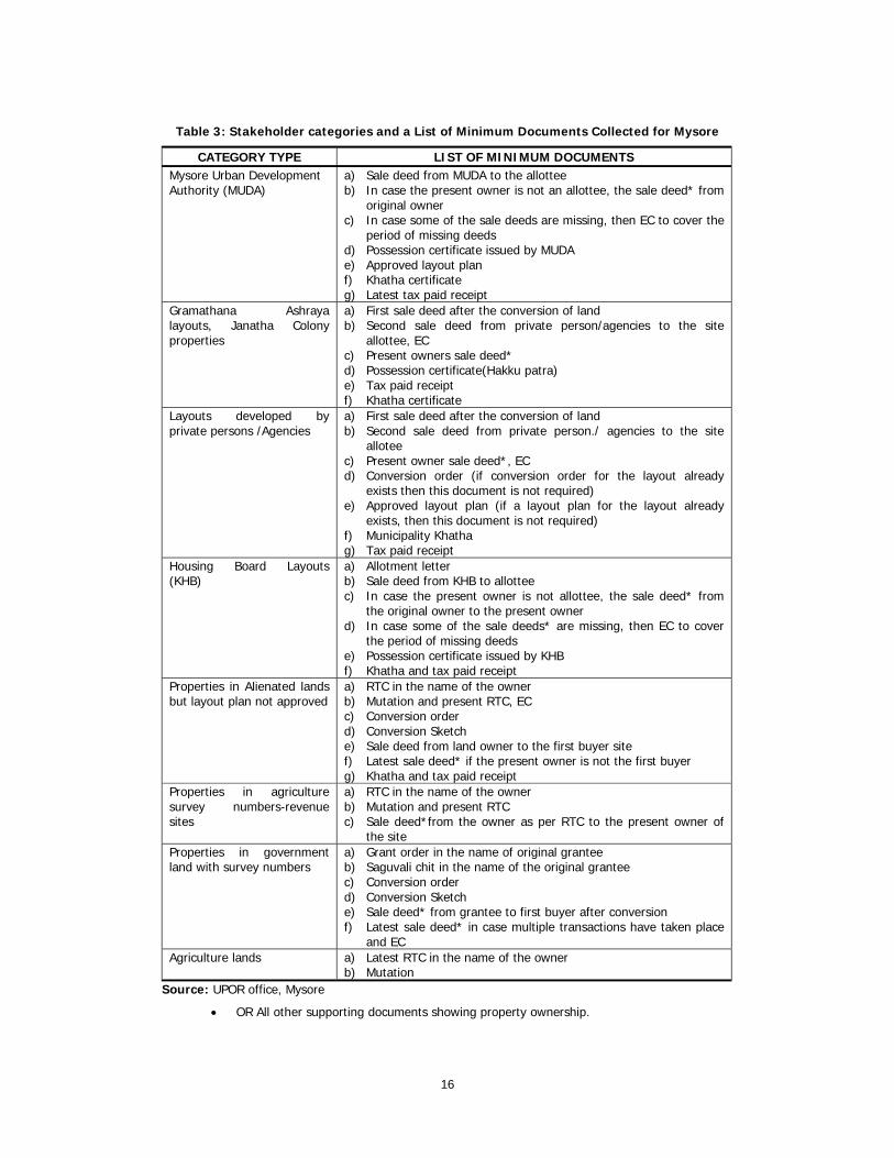
depends on property type and category of stakeholders. Table 3 presents details of stakeholder’s
categories and list of documents collected by the SSLR in Mysore city. The UPOR office in Mysore city
has received about 90,000 documents (files)24. The second step is the detailed spatial planning to be
carried out for demarcating and categorizing the properties in the city (see Table 3).
As each individual property is unique, in terms of coordinate25 measurements, the entire city is
divided into zones, sectors and village properties. The city of Mysore is divided into 11 zones, 50
sectors, and 42 villages. As the survey knowledge of service providers is inadequate, 32 surveyors have
been appointed by the department for the measurement of individual properties in the city.
23 Quantifiable details are collected from UPOR office, Mysore. 24 Quantifiable details presented in this chapter for Mysore is up to December 2011. 25 Coordinates for each property is fixed based on easting, westing, southing and northing measurements in the city.
16
Table 3: Stakeholder categories and a List of Minimum Documents Collected for Mysore
CATEGORY TYPE LIST OF MINIMUM DOCUMENTS Mysore Urban Development Authority (MUDA)
a) Sale deed from MUDA to the allottee b) In case the present owner is not an allottee, the sale deed* from
original owner c) In case some of the sale deeds are missing, then EC to cover the
period of missing deeds d) Possession certificate issued by MUDA e) Approved layout plan f) Khatha certificate g) Latest tax paid receipt
Gramathana Ashraya layouts, Janatha Colony properties
a) First sale deed after the conversion of land b) Second sale deed from private person/agencies to the site
allottee, EC c) Present owners sale deed* d) Possession certificate(Hakku patra) e) Tax paid receipt f) Khatha certificate
Layouts developed by private persons /Agencies
a) First sale deed after the conversion of land b) Second sale deed from private person./ agencies to the site
allotee c) Present owner sale deed*, EC d) Conversion order (if conversion order for the layout already
exists then this document is not required) e) Approved layout plan (if a layout plan for the layout already
exists, then this document is not required) f) Municipality Khatha g) Tax paid receipt
Housing Board Layouts (KHB)
a) Allotment letter b) Sale deed from KHB to allottee c) In case the present owner is not allottee, the sale deed* from
the original owner to the present owner d) In case some of the sale deeds* are missing, then EC to cover
the period of missing deeds e) Possession certificate issued by KHB f) Khatha and tax paid receipt
Properties in Alienated lands but layout plan not approved
a) RTC in the name of the owner b) Mutation and present RTC, EC c) Conversion order d) Conversion Sketch e) Sale deed from land owner to the first buyer site f) Latest sale deed* if the present owner is not the first buyer g) Khatha and tax paid receipt
Properties in agriculture survey numbers-revenue sites
a) RTC in the name of the owner b) Mutation and present RTC c) Sale deed*from the owner as per RTC to the present owner of
the site Properties in government land with survey numbers
a) Grant order in the name of original grantee b) Saguvali chit in the name of the original grantee c) Conversion order d) Conversion Sketch e) Sale deed* from grantee to first buyer after conversion f) Latest sale deed* in case multiple transactions have taken place
and EC Agriculture lands a) Latest RTC in the name of the owner
b) Mutation Source: UPOR office, Mysore
• OR All other supporting documents showing property ownership.
17
In the third step, government surveyors identify property corners which are critical to
determining the boundaries of properties. The discretion of private agency is not considered for this
critical activity. Here, all the three control points network (PCPs, SCPs and TCPs) and assign a ‘value’ for
each property. These values are fixed for all the properties including roads, lakes and public
establishments in the city and used as coordinates for measuring individual plots/sites and households.
As the fourth step, boundaries are fixed using Electronic Total Stations (ETS) to arrive at coordinates.
As the work proceeds, in the fifth step, using UPOR vectorization software, property maps are
prepared, also referred to as ‘Index Mapping’. Maps are generated for the entire city survey jurisdiction.
A Detailed survey map is generated depicting roads, public establishments and households. Complete
details are collected block, compound and plinth area wise. A relevant notice is issued regarding the
survey date to the individual property owners in the city. Lastly, the survey has to be validated by the
SSLR department as the final step in this process.
2. Departmental Validation of Survey
The department selects 5,000 properties randomly (20 per cent of the work) from each sector and
checks for validation. Going by the coordinates drawn using ETS, a variation between 1 per cent
minimum and 2 per cent maximum is ignored. However, if the difference is 10 per cent for each sector,
then the entire sector is resurveyed.
After mapping of the city properties, in the sixth step, a master data base is generated by
collecting documents from urban authorities, municipalities and individual property owners. For example
municipal data, alienation data, government land, data city survey details (Mysore, Bellary and Hubli-
Dharwad) are collected. Vendors (SP) collect relevant documents from property owners (citizens) in the
city. These documents are scanned using UPOR software before porting the same. Households without
documents are left out. Finally, exception reports are prepared.
3. Entry in Master Data Base Using UPOR Software
After submission of the data and the subsequent porting of the same using the UPOR software, details
are incorporated in the Master Data base. These details include: Basic data entry: (i) Municipal Data;
(ii) Alienation Data; (iii) City Survey Data; (iv) Government Land Data; and (v) Land Acquisition Data.
• Culled out Information : (i) Chalta Number26, (ii) Holder/GPA Details, (iii) Lease Details, (iv)
Issues and Rights, (v) Property Category and (vi) Shared Property.
• Quality Control Data: (i) Municipal Data, (ii) Alienation Data, (iii) City Survey Data, (iv)
Government Land Data, (v) QC culled out information Data Entry, (vi)Holder/GPA details, (vii)
Lease details, (viii) other details, (ix) Issue and Rights and (x) Property Category.
• Scanning and Indexing documents.
• Operators: (i) Field Data entry of government surveyor- rejected records or (ii) Re-data entry
of government- surveyor rejected records.
• Survey Supervisor: (i) Supervisor confirmation 26 Chalta number means plot number. Sub-Chalta number sub-plot number.
18
• SP Supervisor: (i) Notice generation for re-survey/document collection (ii) Notice generation
for title enquiry and (iii) Date of update notice served
• Enquiry officer: (i) Initial approval from EO, (ii) Final approval, (iii) objection entry approval,
(iv) Objection enquiry decision and (v) Abstract report.
• Government Surveyor: (i) Confirmation of enquiry process, (ii) Objection entry (iii) Notice
generation for objection enquiry and (iv) Objection endorsement.
• Generation of government surveyor reports and creation of exception reports and
• Final porting status report for preparation of draft PR cards.
Subsequent to the porting of documents by the SP, the UPOR software groups the various
chaltas27 into: (i) Chaltas with minimum required documents (ii) Chaltas not having the minimum
documents - categorized as chaltas with insufficient documents and (iii) Chaltas or properties with other
lacunas (for example chaltas without owners or notices issued but documents not provided or a single
chalta number block).
12. Third and Final stage of UPOR implementation: Title Enquiry Process
(TEP)
In the third and final stage of UPOR implementation, Title Enquiry (TE) process is initiated. The title
enquiry process is in progress in three cities out of five UPOR cities. Under TE process, four steps are
involved for verifying the ownership claims of properties and the preparation of draft property cards
(DPC). They include:
• Based on the data collected during first and second stages, the title enquiry process gets initiated
by TE team.
• Confirmation of tenure and boundaries of the properties
• Preparation of draft Property Cards
• Preparation of final Property Card, Enquiry Register and Property Maps
Compliance with respect to legal aspects of implementation of
UPOR project28 Efficient service delivery is the essence of UPOR project. To regulate the relationship with various
partners such as (i) service providers (ii) department of SSLR (iii) project organization and (iv) key
stakeholder departments, a set of Service Level Agreements (SLAs) have been drawnup for (a) time
bound implementation of the project and (b) delivery of services to the stakeholders. The RFPs clearly
mention the legal and commercial implications of compliance and non-compliance with respect to both
SP and TSP as specified in Volume III of RFP. Besides, all the partners and participants design their
system of functional requirements to enable compliance with the SLA.
27 Details collected from Circulars (2010-11), UPOR, Department of Revenue, Bangalore. 28 Source from UPOR webpage, www.upor.karnataka.gov and RFP (2009: 23-24).

19
1. Privacy Protection of UPOR29
There were physical barriers to accessing property records in the pre-UPOR phase. However, with the
computerization of property records through UPOR project, SSLR aims to protect the confidentiality of
property ownership details which could be shared only by property owners.
Accordingly, some essential security measures have been taken by both SP and TSP for
maintaining property confidentiality of records through biometrics/PKI. These are -
• Biometric security: Property owners or those who have interest in the property like GPA
holders or lease holders enroll biometric identification unit of the department. Such biometric
based identification is considered for only those property owners whose property is worth less
than Rs 1.00 crore.
• PKI security: Financial institutions like banks that accept mortgages against property or
property owners compulsorily enroll for PKI based identification security with the department.
All the services delivered by UPOR are PKI and biometric enabled and all services of UPOR are
certified either through PKI or biometrics by the authorized signatories.
2. Provision of Services to External Agencies30
SSLR shares the cadastral data with the public agencies on request free of cost or on case to case basis
if such services are not listed in the table. Sometimes it may be chargeable using infrastructure of SP
and TSP with the share of revenue being 75 per cent and 15 per cent respectively. If datasets are
requested by the private agencies, such requests are studied by SSLR which enjoys the absolute right to
accept or reject. Further, such requests are considered on the basis of 75 per cent and 15 per cent
share of revenue.
3. UPOR project31 - Expansion Portfolio
In case of any expansion of portfolio or addition of more services to the UPOR project, both SP and TSP
are to comply with by providing additional services without any additional charges. Further, both SP and
TSP are to recover the charges only through user charges during provisioning of services, In case of any
services that cannot be related to the existing category of services the charges to be paid to both SP
and TSP as decided by the PMC on 75:15 share basis.
Channels of Service Delivery32 SSLR is expected to deliver UPOR project services through 1-3 citizen service centres in every city.
Channels of service delivery or the integration process are developed by UPOR project for enhancing
29 Source from RFP (2009:20). 30 Source from RFP (2009: 21) 31 Source from RFP (2009: 23). 32 Notes from RFP (2009:11).

20
the convenience of citizens and also facilitating efficient service delivery. As on date, one Citizen
Facilitation centre each has been set up and functioning at both Mysore and Shimoga.
1. Expected Services from UPOR
It is expected that Services under the Urban Property Ownership Records Project will be delivered from
Service Centres which may range between one and three in each project area. These centers have
already been set up by SSLR in every city. The exact number of service centers is given in Section 1.1.
of Vol 1C of the RFP for Selection of Service Providers. In addition to these physical service centers,
government would also facilitate delivery of service through:
Citizen Service Centres (CSCs) are promoted by government agencies like Nemmadi/Bangalore,
One/Hubli-Dharwad one for accessing multiple services including UPOR.
UPOR services are also delivered through Commercial Internet centres.
Citizens can access some services of UPOR through own service Internet portals.
UPOR promotes networking with government establishments and banks for accessing
information from both the sources (see Chart below).
CHART
INTERNET
SHIMOGA MUNICIPALITY
BELLARYMUNICIPAL
CORPORATION
MANGALOREMUNICIPAL
CORPORATION
MYSOREMUNICIPAL
CORPORATION
HUBLI DHARWADMUNICIPAL
CORPORATION
SERVICE CENTRES
BANK
COURT
REGISTRATION DEPARTMENT
URBAN PROPERTY RECORDS DATABASE
FUNCTIONAL ARCHITECTURE OF INTEGRATION PROCESS IN RESPECT OF URBAN PROPERTY RECORDS PROJECT, KARNATAKA
Source: RFP (2009: 11)

21
Experiences gained from UPOR Project As stated in earlier paragraphs, the UPOR project has commenced operation in five cities of the State.
However, tangible progress has been achieved only in Mysore with almost 90% of the 2.75 lakh
properties having identified and the survey completed.
As regards the other cities, Hubli-Dharwad (50 per cent) and Shimoga (70 per cent) have
registered good progress. The experience gained in Mysore, Hubli-Dharwad and Shimoga is found
relevant for the present analysis as the scale of operation in these cities was considerably bigger
operation as compared to other cities (see Flow Chart II and Flow chart III).
Flow Chart II: Stages of UPOR Implementation Process
Set Up Control Networks
Detailed Survey of Properties
Title Enquiry Process
Issue of PR cards
Citizen Service Delivery
Source: UPOR Office, Mysore
A
B
C
D
E
22
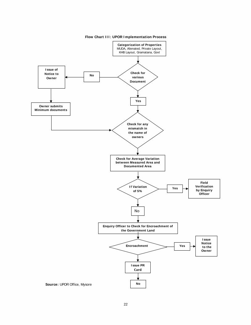
Flow Chart III: UPOR Implementation Process
Source: UPOR Office, Mysore
Check for Average Variation between Measured Area and
Documented Area
If Variation of 5%
Yes
Field Verification by Enquiry
Officer
No
Enquiry Officer to Check for Encroachment of the Government Land
Encroachment
Issue Notice to the Owner
Issue PR Card
No
Check for any mismatch in the name of
owners
Check for various
Document
Issue of Notice to
Owner
Owner submits Minimum documents
No
Yes
Categorization of Properties MUDA, Alienated, Private Layout,
KHB Layout, Gramatana, Govt
Yes
23
Section III
Demand for Property Cards from Stakeholders
A stakeholder, by definition, is one with an interest or concern in something. It can be a person, group
or organisation having a direct or indirect stake in an organization or activity. Although in respect of a
project like UPOR, all are to be considered as stakeholders, but not all are equal given their differing
interests and the roles they play. Therefore, there can be primary level and secondary level
stakeholders, but all are to be an integral part of a project. They can be the end users or clients, people
from whom requirements are drawn, people who help, organize and influence the design and finally
people who reap the benefits of the completed project. Hence, the involvement of all stakeholders is
extremely important as it contributes to the success of a project as a concept, besides building
confidence in the project, and ultimately resulting in complete acceptance by the target group. These
groups can be broadly categorized into executive level, expert level and end user level. An attempt is
made to assess the viability of this major intervention in the property titling process after having gained
a clear understanding of the problems faced by different types of users of the scheme and demands
from these quarters.
1. Key Stakeholders
The present UPOR project has been launched with the assumption that such an intervention will be
useful to citizens. Therefore, an attempt is made here to understand the expectations of different types
of users and also to identify the potential users especially of TEP data base. These institutions across
society will ultimately play an important role in determining the design of a pricing strategy, extent of
coverage, compliance from SPs for the UPOR project and the associated database to remain an
economical proposition from the investors’ point of view. As a primary stakeholder, the department has
finalized a detailed RFP for SPs and TSPs of the UPOR task, inclusive of documents for detailing the
roles and responsibilities, functional and technical specifications, commercial terms and bid documents,
Master Service Agreement etc. Properties belonging to the ULBs, UDA, KHB, in addition, banks, courts
and lawyers, builders, private agencies etc. are major end users of property data. (see Flow Chart IV)

24
Flow Chart IV: Classification of Stakeholders
2. Implementation Constraints of UPOR
The implementation of UPOR project in five pilot cities of Karnataka, has thrown up several process
related obstacles, challenges and constraints. Many of these are known to the various authorities in
government and are being addressed. It is expected that they will be resolved and addressed, else,
might adversely affect the UPOR.
These challenges and obstacles may be broadly classified into four categories. These are –
a) Operational constraints in Government;
b) Staff constraints in Government;
c) Demand related issues in respect of PRCs;
d) Problems in respect of linkages in the UPOR process
Expectedly all these challenges have surfaced during the implementation of UPOR. As oberved
during the study, that these problems have been identified by the authorities concerned. Also, there
have been attempts at resolving them at various levels in government. However, some of the issues
and problems still persist. They may have to be taken note of, at higher levels in government and
Primary
Dept of City Survey
Local Development Authorities 1. Urban Development Department 2. City Municipal Corporation 3. Town Planning Authority 4. Karnataka Slum Clearance Board (KSCB) 5. KIADB and KSSIDC
Civil Society 1. Residential Welfare Associations 2. Community Based Organisations (CBOs) 3. Industrial Associations
Private Vendors 1. Service Provider (SP) 2. Technical Service Provider (TSP)
Secondary
1. Slum Dwellers 2. Unauthorized Settlements 3. Other agencies that access UPOR services
Land Owners/Clientele 1. Residential/Commercial 2. Builders/Land Developers 3. Industries
1. Banks 2. Courts and Legal Experts
Stakeholders

25
appropriate decisions taken to resolve them. Otherwise, there is every possibility that they may become
hindrances in the speedy and timely completion of the project.
3. Slums and UPOR
Slums constitute one of the significant portions of urban centres. At present, these areas have been
marked under the UPOR project though individual level titling process is yet to commence. The slum
areas are marked as individual blocks in the survey; therefore, UPOR has not processed any individual
documents belonging to authorised slums.
Most of the slums are located either on (i) private (ii) vacant or (iii) government land. The slums
located on government land will be authorised under city Municipal Corporation or urban development
authority regulations. Only authorised slums will receive ‘Hakku patras’ or ‘Possession certificate’ or
‘Niveshana patra’ and these documents will be issued on lease for a period of 20 years. Besides, the
slums on authorised land have to pay beneficiary contributions to City Municipal Corporation (CMC) to
transfer the land on registration. The number of slums on private land or unauthorised ones is more
than that s on government land with authorisation. Most of the slums located on private land and
vacant lands are subject to disputes and are categorized as unauthorised or illegal slums. Unauthorized
slums do not posses documents to validate their stay it the city; therefore UPOR has processed only
documents of authorised slums.
Table 4: Status of Slums under UPOR
Details Hubli- Dharwad Mysore Bellary Shimoga
Authorized slums 73 Hubli
33 Dhawad 86 53 48
Authorized slums identified as blocks 10 86 53 48
No. of unauthorized slums - 72 11 11
Ashraya Colonies 3 7 - -
Source: Field Survey from Pilot Cities of UPOR
Most of the authorized slums are identified as blocks (see table 4). The table above presents
the number of authorised and unauthorised slums in the pilot cities of UPOR. In all the five pilot cities of
UPOR, currently the whole area of authorised slum is declared as single chalta and block. Once
properties are regularized by the concerned departments like City Corporation or UDA, these properties
will later receive single chalta numbers and will become eligible for draft property card. The same
procedure is applied to slums/tenements on agriculture land. These slum dwellers receive ‘Hakku-
Patras’ on lease basis for 20 years. They have to make a monthly payment of Rs 10 to City
Corporation/UDA for 20 years. UPOR has issued notice to authorized slums r with Hakku-Patras which
could make them eligible for draft PR card as ‘lease-holders’. In addition, there are certain central
government schemes for construction of houses for slum dwellers with beneficiary contributions. Such
housing schemes include (i) HUDCO scheme (ii) 3 SCP houses (iii) VAMBAY houses and (iv) NBA toilet

26
blocks. Four hundred and forty-one houses have already been built under IHSDP housing and
infrastructure scheme in Hubli.
Concluding Remarks The existing urban land management practices in Karnataka have been analyzed from various contexts,
like objectives and effects of urban land tenure and related practices. The objective of this paper is to
capture and document the process and implementation of UPOR in five cities. The new and highly
innovative solutions to the existing disintegrated land management practices appear to support the
need for land reforms and thereby promote effective land governance.
It is hoped that, over a period of time, all these matters will be taken cognizance of, by the
concerned authorities in government. Once they are examined and appropriate decisions taken, the
UPOR could well revolutionize the systems of land governance in urban areas in Karnataka.
References Burns, Tony (2007). Land Administration Reform: Indicators of Success, Future Challenges. Agriculture
and Rural Development Discussion Paper 37. Washington DC: The World Bank.
Chawla, Rajiv (2004). Online Delivery of Land Titles to Rural Farmers in Karnataka, India. Paper
presented at Seminar titled ‘Scaling Up Poverty Reduction: A Global Learning Process and
Conference’, Shanghai, May 25-27.
Dowall, David E and Giles Clark (1996). A Framework for Reforming Urban Land Policies in Developing
Countries. Washington DC: The World Bank.
Mckenzie (2001). India the Growth Imperative. Washington DC: Mckinsey Global Institute.
Mukerji, Anirban (2011). Urban Property Ownership Records: Background Document. Access from
(http://www.slideshare.net/anirmukerji/urban-property-ownership-records-background-
document) on dated November 20th 2011.
Pathak, R D and R S Prasad (2005). Role of E-governance in Tackling Corruption and Achieving Societal
Harmony: Indian Experience. Paper presented at Workshop on ‘Innovations in Governance and
Public Service to Achieve a Harmonious Society’, Beijing: NAPSIPAG.
Ramanathan, Swathi (2009). Security of Title to Land in Urban Areas in ‘Indian Infrastructure Report:
Land-A Critical Resource for Infrastructure’, 3iNetwork and Infrastructure Development Finance
Company. New Delhi: Oxford University Press.
Roy, Subir (2007). Bhoomi: A Revolution in Rural Land Record System. Access from
http://ia.rediff.com/money/2007/apr/10spec1.htm on 12th November 2011
Sarah, A (2003). “Information Technology & Governance”, NALSAR University of Law, Shamirpet, AP,
India. Available on :http://loksatta.org/itgovernance.pdf#search
='Information%20Technology%20%26%20Governance,
UDP (2009). Urban Development Policy for Karnataka. Bangalore: Urban Development Department.
Wadhwa, D C (1989). Guaranteeing Title to Land: A Preliminary Study. Economic and Political Weekly,
24 (41): 2323-2331+2333-2334.

27
————— (2002). Guaranteeing Title to Land, Economic and Political Weekly, 37 (47): 4699-4722.
Documents Accessed
Request For Proposal (2009). Selection of Service Provider for Urban Property Ownership Records
Project, Volume I A, Bangalore: Commissioner Survey Settlement and Land Records.
Request for Proposal (2009b). Selection of SP for Urban Property Ownership Records Project, Volume II
(Commercial Terms and Bid Documents), Reference –Notification Number STR: 05 TCS: 4: 09-
10, Bangalore: Commissioner Survey Settlement and Land Records.
Press Note (2011). Press noted was released on December 11 2011 at Mysore during Chief Minister of
Karnataka Mr. Sadananda Gowda visit to distribute UPOR certificates to some Mysore property
owners.
The Deccan Herald (2011). Unique 'Property Cards' for Mangaloreans, Accessed from
(http://www.daijiworld.com) dated November 14th 2011.
The Hindu (2011). UPOR cards to be distributed soon. Dated July 20th. Access from www.thehindu.com

245 Is Young Maternal Age A Risk Factor forSexually Transmitted Diseases andAnemia in India? An Examination in Urbanand Rural AreasKavitha N
246 Patterns and Determinants of FemaleMigration in India: Insights from CensusSandhya Rani Mahapatro
247 Spillover Effects from MultinationalCorporations: Evidence From West BengalEngineering IndustriesRajdeep Singha and K Gayithri
248 Effectiveness of SEZs Over EPZsStructure: The Performance at AggregateLevelMalini L Tantri
249 Income, Income Inequality and MortalityAn empirical investigation of therelationship in India, 1971-2003K S James and T S Syamala
250 Institutions and their Interactions:An Economic Analysis of IrrigationInstitutions in the Malaprabha DamProject Area, Karnataka, IndiaDurba Biswas and L Venkatachalam
251 Performance of Indian SEZs: ADisaggregated Level AnalysisMalini L Tantri
252 Banking Sector Reforms and NPA:A study of Indian Commercial BanksMeenakshi Rajeev and H P Mahesh
253 Government Policy and Performance: AStudy of Indian Engineering IndustryRajdeep Singha and K Gayithri
254 Reproduction of Institutions throughPeople’s Practices: Evidences from aGram Panchayat in KeralaRajesh K
255 Survival and Resilience of Two VillageCommunities in Coastal Orissa: AComparative Study of Coping withDisastersPriya Gupta
256 Engineering Industry, CorporateOwnership and Development: Are IndianFirms Catching up with the GlobalStandard?Rajdeep Singha and K Gayithri
257 Scheduled Castes, Legitimacy and LocalGovernance: Continuing Social Exclusionin PanchayatsAnand Inbanathan and N Sivanna
258 Plant-Biodiversity Conservation inAcademic Institutions: An EfficientApproach for Conserving BiodiversityAcross Ecological Regions in IndiaSunil Nautiyal
259 WTO and Agricultural Policy in KarnatakaMalini L Tantri and R S Deshpande
260 Tibetans in Bylakuppe: Political and LegalStatus and Settlement ExperiencesTunga Tarodi
261 Trajectories of China’s Integration withthe World Economy through SEZs: AStudy on Shenzhen SEZMalnil L Tantri
Recent Working Papers262 Governance Reforms in Power Sector:
Initiatives and Outcomes in OrissaBikash Chandra Dash and S N Sangita
263 Conflicting Truths and ContrastingRealities: Are Official Statistics onAgrarian Change Reliable?V Anil Kumar
264 Food Security in Maharashtra: RegionalDimensionsNitin Tagade
265 Total Factor Productivity Growth and ItsDeterminants in Karnataka AgricultureElumalai Kannan
266 Revisiting Home: Tibetan Refugees,Perceptions of Home (Land) and Politicsof ReturnTarodi Tunga
267 Nature and Dimension of Farmers’Indebtedness in India and KarnatakaMeenakshi Rajeev and B P Vani
268 Civil Society Organisations andElementary Education Delivery in MadhyaPradeshReetika Syal
269 Burden of Income Loss due to Ailment inIndia: Evidence from NSS DataAmrita Ghatak and S Madheswaran
270 Progressive Lending as a DynamicIncentive Mechanism in MicrofinanceGroup Lending Programmes: EmpiricalEvidence from IndiaNaveen Kumar K and Veerashekharappa
271 Decentralisation and Interventions inHealth Sector: A Critical Inquiry into theExperience of Local Self Governments inKeralM Benson Thomas and K Rajesh
272 Determinants of Migration andRemittance in India: Empirical EvidenceJajati Keshari Parida and S Madheswaran
273 Repayment of Short Term Loans in theFormal Credit Market: The Role ofAccessibility to Credit from InformalSourcesManojit Bhattacharjee and Meenkashi Rajeev
274 Special Economic Zones in India: Arethese Enclaves Efficient?Malini L Tantri
275 An Investigation into the Pattern ofDelayed Marriage in IndiaBaishali Goswami
276 Analysis of Trends in India’s AgriculturalGrowthElumalai Kannan and Sujata Sundaram
277 Climate Change, Agriculture, Povertyand Livelihoods: A Status ReportK N Ninan and Satyasiba Bedamatta
278 District Level NRHM Funds Flow andExpenditure: Sub National Evidence fromthe State of KarnatakaK Gayithri
279 In-stream Water Flows: A Perspectivefrom Downstream EnvironmentalRequirements in Tungabhadra RiverBasinK Lenin Babu and B K Harish Kumara
280 Food Insecurity in Tribal Regions ofMaharashtra: Explaining Differentialsbetween the Tribal and Non-TribalCommunitiesNitin Tagade
281 Higher Wages, Cost of Separation andSeasonal Migration in IndiaJajati Keshari Parida and S Madheswaran
282 Pattern of Mortality Changes in Kerala:Are they Moving to the Advanced Stage?M Benson Thomas and K S James
283 Civil Society and Policy Advocacy in IndiaV Anil Kumar
284 Infertility in India: Levels, Trends,Determinants and ConsequencesT S Syamala
285 Double Burden of Malnutrition in India:An InvestigationAngan Sengupta and T S Syamala
286 Vocational Education and Child Labour inBidar, Karnataka, IndiaV Anil Kumar
287 Politics and Public Policies: Politics ofHuman Development in Uttar Pradesh,IndiaShyam Singh and V Anil Kumar
288 Understanding the Fiscal Implications ofSEZs in India: An Exploration in ResourceCost ApproachMalini L Tantri
289 Does Higher Economic Growth ReducePoverty and Increase Inequality?Evidence from Urban IndiaSabyasachi Tripathi
290 Fiscal DevaluationsEmmanuel Farhi, Gita Gopinath and Oleg Itskhoki
291 Living Arrangement Preferences andHealth of the Institutionalised Elderly inOdishaAkshaya Kumar Panigrahi and T S Syamala
292 Do Large Agglomerations Lead toEconomic Growth? Evidence from UrbanIndiaSabyasachi Tripathi
293 Representation and Executive Functionsof Women Presidents andRepresentatives in the GramaPanchayats of KarnatakaAnand Inbanathan
294 How Effective are Social Audits underMGNREGS? Lessons from KarnatakaD Rajasekhar, Salim Lakha and R Manjula
295 Vulnerability Assessment Of TheAgricultural Sector In Yadgir District,Karnataka: A Socio-Economic SurveyApproachSarishti Attri and Sunil Nautiyal
296 How Much Do We Know about theChinese SEZ Policy?Malini L Tantri
297 Emerging Trends in E-Waste Management- Status and IssuesA Case Study of Bangalore CityManasi S
298 The Child and the City: AutonomousMigrants in BangaloreSupriya RoyChowdhury
299 Crop Diversification and Growth of Maizein Karnataka: An AssessmentKomol Singha and Arpita Chakravorty
300 The Economic Impact of Non-communicable Disease in China and India:Estimates, Projections, and ComparisonsDavid E Bloom, Elizabeth T Cafiero, Mark EMcGovern, Klaus Prettner, Anderson Stanciole,Jonathan Weiss, Samuel Bakkia and LarryRosenberg
301 India’s SEZ Policy - Retrospective AnalysisMalini L Tantri
302 Rainwater Harvesting Initiative inBangalore City: Problems and ProspectsK S Umamani and S Manasi
303 Large Agglomerations and EconomicGrowth in Urban India: An Application ofPanel Data ModelSabyasachi Tripathi
304 Identifying Credit Constrained Farmers: AnAlternative ApproachManojit Bhattacharjee and Meenakshi Rajeev
305 Conflict and Education in Manipur: AComparative AnalysisKomol Singha
306 Determinants of Capital Structure ofIndian Corporate Sector: Evidence ofRegulatory ImpactKaushik Basu and Meenakshi Rajeev
307 Where All the Water Has Gone? AnAnalysis of Unreliable Water Supply inBangalore CityKrishna Raj
Price: Rs. 30.00 ISBN 978-81-7791-164-0
INSTITUTE FOR SOCIAL AND ECONOMIC CHANGEDr V K R V Rao Road, Nagarabhavi P.O., Bangalore - 560 072, India
Phone: 0091-80-23215468, 23215519, 23215592; Fax: 0091-80-23217008E-mail: [email protected]; Web: www.isec.ac.in