Record of Decision - Agricultural Research Service · Record of Decision 1 Background The USDA,...
58
United States Department of Agriculture Record of Decision U.S. Sheep Experiment Station Grazing and Associated Activities Project Agricultural Research Service Pacific West Area September 2017
Transcript of Record of Decision - Agricultural Research Service · Record of Decision 1 Background The USDA,...

United States Department of Agriculture
Record of Decision
U.S. Sheep Experiment Station Grazing and Associated Activities Project
Agricultural Research Service Pacific West Area September 2017

In accordance with Federal civil rights law and U.S. Department of Agriculture (USDA) civil rights regulations
and policies, the USDA, its Agencies, offices, and employees, and institutions participating in or administering
USDA programs are prohibited from discriminating based on race, color, national origin, religion, sex, gender
identity (including gender expression), sexual orientation, disability, age, marital status, family/parental status,
income derived from a public assistance program, political beliefs, or reprisal or retaliation for prior civil rights
activity, in any program or activity conducted or funded by USDA (not all bases apply to all programs).
Remedies and complaint filing deadlines vary by program or incident.
Persons with disabilities who require alternative means of communication for program information (e.g.,
Braille, large print, audiotape, American Sign Language, etc.) should contact the responsible Agency or
USDA’s TARGET Center at (202) 720-2600 (voice and TTY) or contact USDA through the Federal Relay
Service at (800) 877-8339. Additionally, program information may be made available in languages other than
English.
To file a program discrimination complaint, complete the USDA Program Discrimination Complaint Form,
AD-3027, found online at http://www.ascr.usda.gov/complaint_filing_cust.html and at any USDA office or
write a letter addressed to USDA and provide in the letter all the information requested in the form. To request a
copy of the complaint form, call (866) 632-9992. Submit your completed form or letter to USDA by: (1) mail:
U.S. Department of Agriculture, Office of the Assistant Secretary for Civil Rights, 1400 Independence Avenue,
SW, Washington, D.C. 20250-9410; (2) fax: (202) 690-7442; or (3) email: [email protected].
USDA is an equal opportunity provider, employer and lender.

Record of Decision
i
Table of Contents
Background ...................................................................................................................................................1 Decision .........................................................................................................................................................2 Reason for the Decision.................................................................................................................................3
Other Alternatives Considered ..................................................................................................................5 Alternative 2 – No Grazing Alternative ................................................................................................5 Modified Alternative 3 ..........................................................................................................................6 Modified Alternative 4 ..........................................................................................................................7 Modified Alternative 5 ..........................................................................................................................7 Original Alternatives 1, 3, 4, and 5 .......................................................................................................7 Alternatives Eliminated from Detailed Study .......................................................................................8
Public Involvement ...................................................................................................................................8 Observers ...............................................................................................................................................8 2011 Field Tour .....................................................................................................................................8 Draft Environmental Impact Statement 2011 Comment Period ............................................................8 Revised Draft Environmental Impact Statement 2016 Comment Period ..............................................9
Interagency Coordination ..........................................................................................................................9 Findings Required by Other Laws and Regulations ....................................................................................10
Endangered Species Act ..........................................................................................................................10 National Historic Preservation Act .........................................................................................................13 Clean Air Act ..........................................................................................................................................14 Clear Water Act and Executive Orders for Wetlands and Floodplains ...................................................14 Environmental Justice .............................................................................................................................15
Implementation ............................................................................................................................................15 Administrative Review ................................................................................................................................15 Contact Person .............................................................................................................................................15 Appendix A – Description of the Selected Alternative ...............................................................................16 Appendix B - Project Maps .........................................................................................................................38 Appendix C – Errata for the Final Environmental Impact Statement .........................................................53


Record of Decision
1
Background The USDA, Agricultural Research Service, U.S. Sheep Experiment Station (Sheep Station) in
Dubois, Idaho proposes to continue historical and ongoing grazing and associated activities in
furtherance of its mission to develop integrated methods for increasing production efficiency of
sheep and simultaneously to improve the sustainability of rangeland ecosystems. The Sheep
Station’s Headquarters, Henninger and Humphrey Ranches are located in the Upper Snake River
Plain, approximately six miles north of Dubois, Idaho, which is the Clark County seat, and its
East and West Summer Ranges are in the Centennial Mountains of Montana (Beaverhead
County). Through memoranda of understanding, the Sheep Station also utilizes the Mud Lake
Feedlot (Department of Energy) and the Caribou-Targhee National Forest Meyers Creek, East
Beaver Creek, and Snakey Canyon-Kelly Canyon1 (Snakey-Kelly) allotments (USDA, U.S.
Forest Service).
As shown in Map 1 of Appendix B – Project Maps, the project area includes:
27,930 acres of Agricultural Research Service property at Headquarters, which has office,
laboratory, animal, equipment, and residential buildings, dry-lot facilities for research
throughout the year, lambing facilities, and lands used for spring and autumn grazing and
rangeland research;
Approximately 16,600 acres of Agricultural Research Service property in the Centennial
Mountains of Montana, which is used for summer grazing and rangeland research;
2,600 acres of Agricultural Research Service property at the Humphrey Ranch in Idaho,
which is near Monida, Montana, has animal facilities and equipment buildings, and is used
for spring, summer, and autumn grazing and rangeland research; and
1,200 acres of Agricultural Research Service property at the Henninger Ranch near Kilgore,
Idaho, which has animal facilities and is used for summer grazing and rangeland research.
The lands range in elevation from approximately 4,800 feet to nearly 10,000 feet, with average
annual precipitation that ranges from approximately 10 inches in the Snake River plain to greater
than 21 inches in the Centennial Mountains. Because of its diverse geography, the Sheep Station
has lands that contain subalpine meadow, foothill, sagebrush steppe, and desert shrubland
ecosystems. This diversity provides unparalleled research opportunities within the Agricultural
Research Service.
The primary mission of the Sheep Station is to develop integrated methods for increasing
production efficiency of sheep and simultaneously to improve the sustainability of rangeland
ecosystems. The Sheep Station is managed to meet Agricultural Research Service and USDA
goals as defined in the National Programs, NP 101 and NP 2152. The mission for NP 101 is to
foster an abundant, safe, wholesome and competitively priced supply of animal products
produced in a viable, competitive, and sustainable animal agriculture sector of the U.S. economy.
The mission of NP 215 is to improve food and energy security, while enhancing the natural
resources base by developing and transferring economically viable and environmentally
protective technologies for sustainable range, pasture, forage and turf production systems. The
1 Refer to p. 2, Decision, first bullet. 2 More detail about the Agricultural Research Service National Programs is available on the following
website: https://www.ars.usda.gov/research/programs/
U.S. Sheep Experiment Station Grazing and Associated Activities Project
2
research strategy of the Office of National Programs and Sheep Station is to gain an
understanding of the interactions between sheep and the environments in which they are produced
that can be used to improve sheep production systems and ensure the sustainability of grazing-
land ecosystems.
The environmental analysis of Sheep Station activities was undertaken pursuant to the National
Environmental Policy Act. The final environmental impact statement (FEIS) documented the
analysis of five alternatives to meet this need.
Decision Based upon a comprehensive and lengthy review of all alternatives, modified alternative 1, which
is a continuation of current management, will be implemented. Minor adjustments have been
made to the decision. A review of the adjustments has been conducted and the agency has
determined that the effects are within the range of effects analyzed in the FEIS (see Supplemental
Information Report3).
To meet Agricultural Research Service strategic plan goals and National Program objectives as
well as support the Congressionally-directed mission of the Sheep Station, the ongoing Sheep
Station operations, as described in modified alternative 1, will continue. The selected alternative
(modified alternative 1) is described in detail on pages 35 to 56 of the Final Environmental
Impact Statement. This detailed description is also included in full in Appendix A – Description
of the Selected Alternative (p. 16).
Modified alternative 1 proposed no new federal action. It is a continuation of the historical and
ongoing grazing and associated activities necessary to achieve the mission of the station. Ongoing
activities will continue, which support rangeland and sheep research to increase the production
efficiency of sheep and improve the sustainability of rangeland ecosystems. The decision includes
the following:
Continued current grazing operations on Headquarters pastures, Henninger and
Humphrey Ranches, and East and West Summer Ranges. In addition, the decision
includes continuing to utilize the Forest Service East Beaver and Meyers Creek
allotments and the Department of Energy Mud Lake property (see Map 2 in Appendix B
– Project Maps). Sheep and cattle grazing, as well as limited horse grazing, will be
continued at rates well below the range carrying capacity in a rest rotation fashion.
Although the decision includes grazing the Forest Service Snakey-Kelly Allotments,
these allotments will not be utilized (i.e., no sheep grazing will occur) until the Forest
Service authorizes use for sheep grazing (see Supplemental Information Report3).
Continued use and maintenance of infrastructure, including: sheep trucking routes, sheep
trailing routes, fences, roads, fire lines, and stock water troughs and developments.
Continued maintenance and use of herder camps in trailers on Headquarters Range,
Humphrey Ranch and Henninger Ranch and camp tents on the summer range.
Continued range improvement and range research activities including wildfire mitigation,
prescribed burning, shrub management using prescribed fire and herbicides, and seeding.
3 http://www.ars.usda.gov/News/docs.htm?docid=17878

Record of Decision
3
Continued use of integrated pest management to manage invasive plant populations,
including sheep grazing, biocontrol, and herbicide application.
Continued use of predator avoidance and abatement strategies to minimize conflicts with
large predators, such as full-time sheep herders and guard dogs and minimization of
attractants.
Continued use and implementation of design features, best management practices,
wildlife conservation measures, and monitoring which are designed to minimize impacts
to wildlife, watersheds, and heritage resources.
Reason for the Decision When compared to the other alternatives, alternative 1 (continuation of current management) will
best meet the need to provide for grazing and associated activities at the Sheep Station in support
of the mission of the Agricultural Research Service on in Dubois, Idaho to develop integrated
methods for increasing production efficiency of sheep and simultaneously improve the
sustainability of rangeland ecosystems. The selected alternative allows the Sheep Station to
continue USDA-mandated research obligations in accordance with the Agricultural Research
Service Office of National Programs. Specific National Programs (NP) Action Plan objectives
include:
Improving production and production efficiencies and enhancing animal well-being and
adaptation in diverse food animal production systems (NP 101 Action Plan, Component 1)
Understanding, Improving, and Effectively Using Animal Genetic and Genomic Resources
(NP 101 Action, Component 2)
Measuring and Enhancing Product Quality and Enhancing the Healthfulness of Meat
Animal Products (NP 101 Action, Component 3)
Improved Rangeland Management for Enhanced Livestock Production, Conservation, and
Ecological Services (NP 215 Action Plan, Component 1), which include:
o developing economic livestock grazing systems for rangelands that meet global
food security objectives while being adaptable to changing climate and varying
environmental conditions and preserve the natural resources integrity, and,
o addressing the need for management strategies and practices that enhance and
conserve rangeland ecosystems to provide multiple ecosystem services including
forages for livestock, soil conservation, water quality, control of invasive species,
recreation and wildlife habitat conservation under changing environmental
conditions.
Continuation of current management will meet these research needs by allowing over 100 years
of sheep and rangeland research activities to continue. The research will lead to an understanding
of how land management (e.g., grazing, rest, prescribed fire, seeding, selective plant removal, and
restoration) and disturbance (e.g., wildfire, fire mitigation, grazing, invasive species, and climate
change) affects the long-term health of rangelands. Results from this research will guide land
managers towards implementing management practices that best accommodate multi-use needs,
while simultaneously ensuring sustainable rangeland ecosystems. Furthermore, results from the
research will facilitate livestock producers in selecting sheep that are best suited for rangeland
ecosystems and to manage livestock in a responsible manner that ensures that rangelands remain

U.S. Sheep Experiment Station Grazing and Associated Activities Project
4
robust and capable of providing multiple ecosystem services. No other USDA research facility
provides information relevant to high elevation sheep production in the intermountain west.
Based on the analysis and findings presented in the FEIS, the selected alternative, continuation of
current management, would result in no major adverse effects to the following resources: range,
soils, hydrology, sensitive plants, cultural resources, and several wildlife species (Canada lynx,
grizzly bear, gray wolf, pygmy rabbit, fish and amphibians). Grazing utilization rates are well
below available forage and sustainable grazing systems are utilized. Rangeland resources would
remain in good condition. Soils are stable on all properties/allotments, except Henninger where
there is a downward trend from decreased plant vigor. Effects to hydrology are limited to site-
specific locations and would not be evident at the 6th level watershed. Carnivore use of the
Centennial Mountain range would continue similar to the current condition, and continued
activities would not reduce connectivity in the Centennial Range.
Sheep Station activities also would result in beneficial effects. For example, targeted grazing and
integrated pest management approaches reduce the harmful effects of invasive species, and the
development of a mosaic sagebrush community with prescribe burning minimizes risk of
catastrophic wildfire, enhances sage grouse habitat, and improves forage quality and diversity. In
addition, the Sheep Station is a major employer in Clark County and provides important
economic contributions to local businesses and public services.
The continuation of grazing and associated activities will still result in some negative
environmental effects. These effects were minimized through the continuation of former and
implementation of new conservation measures, design features, and mitigations, as described in
the Design Features, Best Management Practices, Monitoring in Appendix A. There are some
minor ongoing effects to watersheds from certain sheep trails, so design features have been
proposed to stabilize these conditions. Sheep grazing on the headquarters range could affect sage-
grouse breeding, nesting, and early brood-rearing activity; however, short duration and rest
rotation grazing practices minimize the effects. Combined with small, low-frequency prescribed
burns and post-burn resting, Sheep Station management would provide benefits to sage grouse
habitat in the long term; overall the balance of effects to this species would be fairly neutral and
sage-grouse populations would be maintained. Overall, habitat for sage grouse on the Sheep
Station properties would be maintained in a healthy condition. The project may affect, but is not
likely to adversely affect the Yellowstone Distinct Population of grizzly bear because long-
standing conservation measures will remain in place that have minimized potential conflicts
between domestic sheep and grizzly bears. Finally, Sheep Station grazing activities on the Forest
Service Snakey-Kelly allotments4 has the potential to negatively affect the Idaho bighorn herds
reintroduced into the Beaverhead range. Long-standing grazing and monitoring procedures, in
addition to design features previously required by the U.S. Forest Service, have been included to
minimize the risk of transmission.
There has been substantial public concern regarding the Sheep Station grazing activities and
several wildlife species and wildlife habitat connectivity, in general. However, in coordination
with other relevant federal and state agencies, conservation measures and design features were
developed that sufficiently mitigate potential adverse impacts to wildlife. Monitoring to
document and identify wildlife interactions will continue. For example, monitoring for nearby
wild bighorn sheep populations has always been an important component of the Sheep Station
4 Although the decision includes grazing the Forest Service Snakey-Kelly Allotments, these allotments will
not be utilized (i.e., no sheep grazing will occur) until the Forest Service authorizes use for sheep grazing
(see Supplemental Information Report, http://www.ars.usda.gov/News/docs.htm?docid=17878).

Record of Decision
5
grazing program. Coordination with other federal and state agencies will continue in order to
accomplish multi-agency conservation goals and produce relevant research to support land
managers who are conducting high elevation sheep grazing in the intermountain west. This
alternative meets the requirements under relevant federal laws – see Findings Required by Other
Laws and Regulations.
This alternative best meets the purpose and need, while minimizing environmental effects to the
extent practical and meeting the requirements of relevant laws, regulations, and policies.
Other Alternatives Considered In addition to the selected alternative, four other alternatives were considered, which are
discussed below. A more detailed comparison of these alternatives can be found in the FEIS on
pages 65-89.
Alternative 2 – No Grazing Alternative
Alternative 2 was developed in response to the public suggestion that sheep grazing be eliminated
completely from the Sheep Station operation. Grazing would not occur on any of the Agricultural
Research Service lands or allotments. The University of Idaho would either dispose of the sheep
or relocate the sheep to alternative lands outside of this project.
Under alternative 2, with no sheep grazing or associated activities, the Sheep Station could not
study interactions between sheep and the environments in which they are produced, and therefore
does not meet the purpose and need. Alternative 2 would preclude research necessary to the
development of genetic improvement programs needed to enhance adaptability, productivity, and
suitability of sheep that are grazing western U. S. rangelands, and to enable the Sheep Station to
develop and evaluate environmentally adapted breeds and genetic lines of sheep. Alternative 2
would preclude research involving prescribed burning, seeding, and cattle and horse grazing
activities that influence availability of nutrients on western U.S. rangelands and, thus, the well-
being of sheep. Alternative 2 would preclude the co-species grazing with sheep and cattle
required to manage decadent forage, maintain range condition and reduce the risk of fire on
research lands. Alternative 2 would preclude seeding required to evaluate restoration,
rehabilitation, and mitigation activities to manage disturbed sites (e.g., road sides, firebreaks,
historical borrow pits, and mines) that may be susceptible to weed invasion or erosion.
Alternative 2 would preclude integrated pest management components necessary to developing
rangeland monitoring tools. Seeding, prescribed burning, and sheep grazing activities are needed
to evaluate plant species that are developed for rangeland improvement programs. Alternative 2
would jeopardize a 90-year-old rangeland research program, focused on describing post-fire
vegetation dynamics and developing post-fire grazing strategies in mountain big sage and three-
tip sage ecosystems, and a 50-year-old sage grouse monitoring program. Therefore, this
alternative would prevent the Sheep Station from meeting all program objectives.
Ending grazing would have little effect on range resources, except on Henninger range where
vegetation would move to fair condition with an upward trend. Invasive weed control would not
continue. Soils would have slight improvement where grazing is eliminated. Reduced grazing
may reduce hydrological effects, but may not be measurable at the 6th watershed level. Potential
effects to some wildlife species would be reduced compared to alternative 1.
Alternative 2 was the environmentally preferred alternative as defined in 36 CFR 220.3. Question
6A of CEQ’s 40 most-asked questions regarding CEQ’s NEPA regulations defines that term to

U.S. Sheep Experiment Station Grazing and Associated Activities Project
6
ordinarily mean the alternative which best protects, preserves, and enhances historic, cultural, and
natural resources. Under that definition, Alternative 2 (no grazing) was assumed to be the most
environmentally preferable because no Sheep Station grazing or management activities would
take place on Agricultural Research Service lands and Forest Service allotments. While the FEIS
found that there may be some slight improvement in conditions or reduced risk of effects from
this alternative, it should be noted that no data were available to substantiate if indeed this
alternative would result in a net positive impact on the environment. Beneficial practices, such as
treatment of invasive species, mitigation of catastrophic wildfire risk, restriction of hunting, and
erosion-control activities, would be eliminated under this alternative.
While this alternative may have reductions in some environmental effects, it would eliminate all
the research activities conducted by the Sheep Station and does not meet the purpose and need.
Modified Alternative 3
Alternative 3 was developed in response to the public suggestion that sheep grazing be eliminated
in the Centennial Mountains. No sheep grazing would occur on the East Summer Range, West
Summer Range, and Humphrey Ranch east of Beaver Creek, as well as on the following
allotments: East Beaver and Meyers Creek. Sheep grazing would continue to occur on
Headquarters, Henninger Ranch, Humphrey Ranch west of Beaver Creek, and the Snakey-Kelly
allotments (see Fn. 4, p. 4).
Ending sheep grazing on East Summer Range, West Summer Range, and Humphrey Ranch east
of Beaver Creek would have little effect to range resources. Not grazing in the Centennials
would result in greater utilization of the lower elevation properties and a reduced sheep flock. In
addition, this alternative meets the purpose and need less fully because it limits the Sheep
Station's ability to mimic high elevation grazing activities typical of sheep management in the
intermountain west. The use of the high elevation pastures allows the Sheep Station to better meet
Agricultural Research Service Office of National Programs research objectives to study
“interactions between sheep and the environments in which they are produced that can be used to
improve sheep production systems and ensure the sustainability of grazing land ecosystems.”
Sheep producers in the intermountain west use high elevation pastures to produce sheep. To best
mimic and conduct research on typical sheep grazing practices, grazing the Agricultural Research
Service summer ranges is necessary.
While this alternative would have no effect (or potential for reduced effect) to wildlife species, it
is expected that carnivore use of the Centennial Mountain range would continue to be similar to
the current condition, with additional potential for black bears and wolves to more fully utilize the
current habitat within a given home range. Changes in the effectiveness of the Centennial Range
as a wildlife migration corridor remain speculative, but are unlikely since evidence suggests that
Sheep Station activities have a minimal effect to wide ranging carnivore use of the habitat.
Some commenters expressed support for alternative 3 and expressed a desire for Agricultural
Research Service summer rangelands to be open to public recreation use. However, none of the
alternatives that were considered in detail would include opening the Agricultural Research
Service properties for further public recreational use because this is not part of the
Congressionally-designated purpose of the Sheep Station.
Overall, the minor reduction in potential effects to wildlife species using the Centennial Mountain
Range do not warrant selecting an alternative that would eliminate seasonal use of the high
elevation summer ranges.
Record of Decision
7
Modified Alternative 4
Alternative 4 was developed in response to the public suggestion that grazing be eliminated
adjacent and within the grizzly bear primary conservation area. No grazing would occur on the
East Summer Range as well as on the Meyers Creek Allotment. Grazing would continue to occur
on Headquarters, Henninger Ranch, Humphrey Ranch, West Summer Range, and Snakey-Kelly
(see Fn. 4, p. 4) and East Beaver allotments.
Modified alternative 4 has a moderate impact to the program but meets the purpose and need with
some limitations. Because some grazing at high elevations, grazing elsewhere, and supporting
activities would be eliminated or altered, research would be limited. This alternative would limit
research into predator avoidance. Furthermore, this alternative would limit research to develop
management strategies to enhance sheep well-being in diverse production environments.
Alternative 4 may affect, but is not likely to adversely affect the grizzly bear. Effects of this
alternative were found to be similar to alternative 1, however, the potential encounters between
domestic sheep and grizzly bears are reduced.
Overall, this alternative would reduce effects to grizzly bear within the primary conservation area,
while still meeting the purpose and need somewhat. However, this alternative was not selected
because the effects to grizzly bears under alternative 1 are minimized with conservation
measures. The potential benefits to bears are so small (given the historic absence of Sheep
Station-related grizzly mortalities), they do not justify the diminution in research yields that
define the purpose and need.
Modified Alternative 5
Alternative 5 was developed in response to the public suggestion that grazing be eliminated to
avoid areas that are near bighorn sheep range. No grazing would occur on the Snakey-Kelly
Allotments. Grazing would continue to occur on Headquarters, Henninger Ranch, Humphrey
Ranch, East and West Summer Range, Myers Creek allotment, and East Beaver allotment.
Modified alternative 5 has a major impact to the program but meets the purpose and need with
some limitations. Because sheep numbers would be decreased by 40 percent, some grazing and
supporting activities would be eliminated or altered, and research could be limited. Research
currently involving these areas could not occur. Reduced sheep numbers could adversely affect
some existing research.
This alternative would reduce one potential vector for bighorn sheep infection. However, it is
uncertain whether ending Sheep Station sheep grazing on the Snakey-Kelly Allotments would
completely eliminate this potential source of infection to bighorn sheep in the Beaverhead
Mountains. With design features and coordination with the U.S. Forest Service to minimize risk
of infection, alternative 1 sufficiently reduces negative environmental effects.
Original Alternatives 1, 3, 4, and 5
Alternatives 1, 3, 4, and 5 were modified between the 2011 DEIS and the 2016 Revised DEIS.
Changes were made to the proposed action and alternatives to adjust for the loss of Bernice
Allotment and updated to be consistent with current practices:
Operations – changes to sheep numbers, utilization rates, and movements

U.S. Sheep Experiment Station Grazing and Associated Activities Project
8
Range Improvement Activities – prescribed burning, invasive species management, and
other associated activities have been amended to match current practices. In conjunction
with the prescribed burning, new sagebrush management experimental activities are being
proposed, including aerial application of herbicide in strips to serve as fuel breaks.
The original Alternatives were modified to exclude Bernice Allotment from all alternatives, adjust
sheep numbers and pasture movements for alternatives 1, 3, 4 and 5, and include the portion of
Humphrey Ranch that is west of Beaver Creek in the grazed areas for modified alternative 3.
The original alternatives 1, 3, 4, and 5 are no longer feasible and therefore, were not selected.
Alternatives Eliminated from Detailed Study
In addition to the alternatives described above, other alternatives suggested in public comments
were considered. These alternatives were eliminated from detailed study for various reasons.
These alternatives are described on FEIS starting on page 65.
Public Involvement
Observers
Field surveys were conducted by USDA Forest Service, TEAMS Enterprise specialists
throughout the summer of 2009. Observers on the various trips included representatives from
Western Watersheds Project and Defenders of Wildlife.
2011 Field Tour
On August 16, 2011 interested parties and the general public were invited to a field tour on the
Sheep Station. The tour included presentations of various research activities ongoing at the Sheep
Station, including: plant recovery after fires, remote sensing and rangeland monitoring,
biodiversity and ecosystem integrity, climate change and plant populations, soils, grazing and
rangeland management, and environmentally-adapted livestock. Participants included
Agricultural Research Service staff, area livestock producers, researchers, the state Senator’s
office, county commissioners, members of the public and representatives of various non-
governmental organizations, including: Western Watersheds Project, Sierra Club, economic
development region, Natural Resources Defense Council, Greater Yellowstone Coalition, and
National Wildlife Federation.
Draft Environmental Impact Statement 2011 Comment Period
In response to the 2011 DEIS, the Agricultural Research Service received 56 unique comment
letters and over 15,000 form letters from individuals, organizations, agencies, and business
owners. Commenter perspectives varied, but in general, raised similar concerns as those received
on the 2009 Environmental Assessment and in the scoping period for the DEIS. Commenters
expressed concerns about potential impacts of the project, including impacts to wildlife (grizzly
bears, bighorn sheep, wolves, aquatic species, and wildlife corridors), native plants and non-
native invasive species, range, soils and water resources, recreation, cultural resources, public
access, and concerns about the impacts from and to climate change. Many comments included
recommendations or preferences for selecting alternatives or eliminating alternatives. Other
comments focused more on process issues such as NEPA compliance, interagency consultation,
and the overall purpose or mission of the Sheep Station.

Record of Decision
9
Agricultural Research Service began reviewing these comments and responding to the comments
in early 2012. However, soon after the comment period, notification was received that use of the
Bernice allotment would expire in December 2012 and would not be renewed. Due to this
changed circumstance, a supplemental DEIS was initiated in 2013 to incorporate new information
because of losing the Bureau of Land Management Bernice allotment. Preparing the supplemental
DEIS was delayed due to various factors and it was ultimately decided to issue this Revised DEIS
that incorporates relevant information to date. Public comments associated with the 2011
comment period was considered in developing the 2015 DEIS. A detailed response to comments
was prepared and published in Appendix F of the FEIS (http://www.ars.usda.gov/
News/docs.htm?docid=17878).
Revised Draft Environmental Impact Statement 2016 Comment Period
The notice of availability of the Revised Draft Environmental Impact Statement was published on
March 18, 2016, initiating a 45-day comment period. The document was posted to the
Agricultural Research Service website and interested parties who had commented on the project
previously were sent letter or email notice. Following requests from interested parties, the
Responsible Official extended the comment period for an additional 45-days. Written comments
were received from 1,802 individuals and organizations. The correspondence received included
69 unique letters, 2 duplicate letters, 1,722 form letters, and 9 slightly modified versions of the
form letter. A summary of the comments and the Agricultural Research Service responses is
included in Appendix F of the FEIS.
Interagency Coordination The Agricultural Research Service has worked in consultation with other federal agencies in the
conservation of species of concern. As required by the Endangered Species Act, the U.S. Fish and
Wildlife Service was consulted on the effects of Sheep Station operations on threatened and
endangered species such as grizzly bears. The conservation and predator avoidance measures,
described as part of the proposed action, and alternatives were developed in collaboration with
the U.S. Fish and Wildlife Service to facilitate grizzly bear recovery. In addition, the Agricultural
Research Service, Forest Service, Bureau of Land Management, and Idaho Fish and Game are
entertaining several collaborative research ventures. This collaboration(s) would be focused on
many domestic livestock-wildlife issues about habitat use and management, conflict reduction,
and assessment of contact risk. Collaboration with the Sheep Station increases the number of
opportunities for statistically valid research that cannot be conducted elsewhere (see appendix E
of the FEIS).
The Sheep Station coordinates directly with Idaho Fish and Game on numerous wildlife
management strategies including conducting sage grouse lek counts, participation in annual
coordination meetings relative to grizzly bear and wolf management, and information sharing
regarding research proposals including prescribed fire. The Sheep Station has indicated a
willingness to collaborate on research regarding interaction between domestic sheep and wildlife.
The State of Montana has not informed the Agricultural Research Service of any plans to
reintroduce bighorn sheep near the Agricultural Research Service properties in Montana.
The Sheep Station coordinates directly with the Idaho State Historical Preservation Office. Idaho
State Historical Preservation Office has visited the Sheep Station and provided requests and
guidance on preserving the historical appearance of many of the historical buildings. The Sheep

U.S. Sheep Experiment Station Grazing and Associated Activities Project
10
Station has also reached out to the Shoshone-Bannock Tribes during commenting periods, and
have addressed requests that were submitted during the commenting periods.
Findings Required by Other Laws and Regulations This decision to continue current management, as described under alternative 1, is consistent with
the Sheep Station mission and purpose and need. It is also compliant with relevant laws,
regulations, and policies.
Endangered Species Act Effects to federally-listed species are described in detail in the FEIS. Three species that are
currently listed, proposed for listing, or were previously listed are considered (see list below).
Grizzly Bear (previously listed as threatened): The final rule removing the Yellowstone
Distinct Population Segment of grizzly bear from the list of federally-endangered and
threatened wildlife (50 CFR 17) was published in the Federal Register on June 30, 2017
and took effect on July 31, 2017 (82 FR 30502).
Canada Lynx (currently listed as threatened): The project biologist determined the
selected alternative may affect, but is not likely to adversely affect Canada lynx. The U.S.
Fish and Wildlife Service provided a letter that concurred with this determination.
North American Wolverine (not currently listed, proposed to be listed as threatened): The
selected alternative is not likely to jeopardize North American wolverine.
In accordance with the regulations set forth in Section 7 (a) of the Endangered Species Act
consultation with the U.S. Fish and Wildlife Service for the selected action was completed. The
consultation history for effects to threatened and endangered wildlife is described below. There
are no effects to federally-listed plant species.
On May 6, 2008, and again on August 14, 2009 a list of threatened, endangered, and proposed
species that may be present in the action area was discussed with the U.S. Fish and Wildlife
Service (Arena 2008, personal communications; USDI Fish and Wildlife Service 2009). Results
of these discussions concluded that only Canada lynx, Yellowstone Distinct Population of grizzly
bear, and Northern Rocky Mountain gray wolf (currently delisted) have the potential to occur in
or near the project area. At the time, no other species with federal listing status occurred in the
area. No critical habitats occurred in the project area.
A review of available information was conducted to assemble occurrence records, describe
habitat needs and ecological requirements, and to determine whether additional field
reconnaissance is needed to complete the analysis. Sources of information included interviews
with Sheep Station staff, interviews with Forest Service biologists on the Caribou-Targhee
National Forest, interviews with state wildlife agency employees, review of Idaho and Montana
State Natural Heritage Program databases, and published research. An independent wildlife
biologist (employed by the USDA Forest Service – TEAMS Enterprise Unit) visited the sites on
four separate occasions including May 6th through 8th, 2008; July 6th through 14th, 2008; June
21st through 26th, 2009, and August 17th through 21st, 2009 to verify wildlife habitat types,

Record of Decision
11
observe resource conditions, review details of proposed activities, gather additional site
information, and contact local biologists from state and federal agencies.
2008 - Interim U.S. Sheep Experiment Station and Associated Grazing Activities
The project biologist met informally several times with United States Fish and Wildlife Service
staff in Chubbuck, Idaho (Arena 2008, personal communication). The initial meeting conducted
on May 6, 2008 familiarized the Fish and Wildlife Service biologist with the project location and
description of proposed activities. At that time, the project biologist and Fish and Wildlife Service
biologist reviewed a list of species in or near the project area having federal status. A preliminary
discussion of species occurrences in the area and potential project effects indicated that Canada
lynx was the only federally-listed species and that effects are unlikely or minimal.
One federally-listed plant species, Ute ladies’-tresses (Spiranthes diluvialis), has been
documented or has potential habitat near the geographic area of the Sheep Station. Upon review
with the Fish and Wildlife Service, it was agreed there is no habitat in the project area.
Additional phone calls and email exchanges occurred in September and October 2008 to review
potential effects to species, clarify procedural questions, and agree that the Sheep Station would
work with the Chubbuck, ID Fish and Wildlife Service office as the lead contact. On December 9,
2008, the Fish and Wildlife Service concluded the consultation process for the interim grazing
activities by providing written concurrence with the project biologist's determination of effects on
listed species which included “Not Likely to Adversely Affect” Canada lynx (USDI Fish and
Wildlife Service 2008). Similarly, the Fish and Wildlife Service acknowledged the biologist's
determination that the project was “Not Likely to Jeopardize the Continued Existence of Gray
Wolf.”
2009 - U.S. Sheep Experiment Station and Associated Grazing Activities
On August 14, 2009, the biologist met with the U.S. Fish and Wildlife Service in Chubbuck, ID to
again start the process of consultation. This phase of the project is the same as the interim phase,
but activities and effects are considered over a longer time period, with more extensive scoping
and public review. At the time of this meeting, (USDI Fish and Wildlife Service 2009) Canada
lynx was the only listed species in the project area. The northern Rocky Mountain distinct
population segment of gray wolf had been delisted on May 4, 2009.
In September 2009, grizzly bears in the Yellowstone distinct population segment were restored as
a threatened species. On October 1, 2009 the biologist contacted the Fish and Wildlife Service to
discuss the recent court order relisting the Yellowstone distinct population segment of grizzly
bear. Discussions included possible determinations and consultation process for control actions
including hazing, trap and transport, lethal control, and personal safety if a herder is threatened by
a bear. Similarly, the Sheep Station expressed their desire to participate in any upcoming Level 1
streamlined consultation meetings that occur between the Fish and Wildlife Service and the
Caribou-Targhee National Forest, which also were likely to include discussions regarding
previously analyzed projects in grizzly bear habitat. Based on the results of these discussions and
a minimal history of Sheep Station encounters with grizzly bears (none with lethal control), the
Sheep Station director concluded that the proposed action and alternatives do not include trap and
transport or lethal control. These activities have not occurred in the past and are not expected to
occur in the future.

U.S. Sheep Experiment Station Grazing and Associated Activities Project
12
Greater sage-grouse, pygmy rabbit, and northern Rocky Mountain gray wolf are all species that
are not federally listed, but were recently either federally-listed or petitioned. Therefore, there is
some possibility that one or all the species could become federally listed. These species occur on
Sheep Station properties and should they become listed, the Sheep Station would need to initiate
(or reinitiate) consultation on the potential effects the proposed activities may have on these
species. Considering this, the wildlife analysis performed for this DEIS considers whether
continued operation (proposed action) would cause any irreversible or irretrievable commitment
of resources to these three species, vis-à-vis effects analysis. The wildlife analysis found that
continued operations would not make such a commitment.
For the wolf, Sheep Station activities were analyzed in the 2008 wildlife report when the wolf
was designated as a nonessential experimental population. The biologist’s analysis and “No
Jeopardy” determination was reviewed and recognized by the Fish and Wildlife Service. Wolves
are no longer listed or proposed in Montana and Idaho, where the project occurs, so a biological
determination is not required. The effects of the revised proposal are minimal and the same as
those described in the 2008 biological analysis, so no further analysis will be completed. Should
sage-grouse or pygmy rabbit become listed or critical habitat designated within the project area,
prescribed burning activities would be deferred until consultation is completed. The current
project proposal would not hinder or prevent the Sheep Station from implementing reasonable
and prudent alternatives to protect those species (such as delaying prescribed fire treatments or
modifying grazing strategies) until the consultation process is completed.
2011 – Biological Assessment Submitted for U.S. Sheep Experiment Station and Associated Grazing Activities
On August 19, 2011, the biologist submitted a Biological Assessment (BA) to the U. S. Fish and
Wildlife Service. This BA found that projects activities “May Adversely Affect” grizzly bears in
the Yellowstone Distinct Population Segment, and were “Not Likely to Adversely Affect” Canada
lynx. The purpose of the 2011 BA was to accommodate that grizzly bears were returned to the list
as a threatened species, and to account for potential take to grizzly bears that could occur because
of habituation to Agricultural Research Service domestic sheep as a food source resulting in lethal
control measures on adjacent private lands.
2011 – Biological Opinion Issued by U.S. Fish and Wildlife Service
On November 8th, 2011, the U. S. Fish and Wildlife Service issued a Biological Opinion
regarding Sheep Station Activities effects on grizzly bears. The Opinion found effects from the
project are not likely to jeopardize the grizzly bear. The Fish and Wildlife Service also concurred
with the project biologist’s finding that activities were “Not Likely to Adversely Affect” Canada
lynx.
2013 – The Project Action Changed by Eliminating Sheep Grazing on BLM Bernice Allotment
The project change was to eliminate sheep and livestock grazing that occurs on the Bernice
Allotment (BLM ownership), and maintain the animals with harvested feed in the Mud Lake
Feedlot during that portion of the winter. Both areas are outside of grizzly bear or lynx habitat.
On February 11th, 2013, the project biologist submitted a letter to the Fish and Wildlife Service
Field Supervisor stating that “The existing Biological Opinion (page 19) indicates that specific
project grazing areas that affect grizzly bears are Tom’s Creek, Big Mountain, O’Dell, Henninger
Ranch, and Meyer’s Creek” (USDA Forest Service ownership). Livestock use and other activities

Record of Decision
13
on these grazing areas is unaffected by the proposed change to the project, and thus, will remain
the same as was analyzed previously. The biologist concluded that the existing consultation and
resulting Biological Opinion would remain applicable and that there was no need to reinitiate
consultation (unless contacted immediately and requested otherwise by the U.S. Fish and Wildlife
Service).
2014 – U.S. Fish and Wildlife Service Issues a Revised Biological Opinion
On May 30th, 2014, the U. S. Fish and Wildlife Service issued a new Biological Opinion that
incorporated updated baseline information, and considered input received from Agricultural
Research Service in a May 16th, 2014 letter and a subsequent interagency Level 2 consultation
meeting on May 20th, and another ARS letter issued May 28th, 2014. The Service’s review of
additional information did not change the no jeopardy conclusion.
2015 - U.S. Fish and Wildlife Service Issues a Revised Biological Opinion
On February 25, 2015, the U.S. Fish and Wildlife Service again issued an amendment Biological
Opinion on effects of the Sheep Station grazing program effects to the threatened grizzly bear.
The Service reviewed and considered information presented in additional relevant documents, as
well as other relevant scientific data, and found that the information did not change the no
jeopardy conclusion. The Biological Opinion remains in effect today.
2016 – Proposed Listing of Wolverine
North American wolverine which has suitable habitat in the action area, has been proposed as
threatened under the Endangered Species Act, as amended (U.S. Fish and Wildlife Service
2016b). Conferencing with the U.S. Fish and Wildlife Service for wolverine is not required unless
the action may jeopardize the species.
2017 – Delisting of the Yellowstone population of grizzly bear
On June 22, 2017, the Secretary of the Interior announced that the Yellowstone population of the
grizzly bear has been recovered to the point where federal protections can be removed and overall
management can be returned to the states and tribes. The final rule removing the Yellowstone
Distinct Population Segment of grizzly bear from the list of federally-endangered and threatened
wildlife (50 CFR 17) was published in the Federal Register on June 30, 2017 and took effect on
July 31, 2017 (82 FR 30502). Despite the delisting of the species, the Sheep Station will continue
to utilize the conservation measures, as described in this decision and will continue to coordinate
with state and federal agencies on grizzly bear management and monitoring.
National Historic Preservation Act Section 106 of the National Historic Preservation Act (NHPA) requires federal agencies to
consider the effects that their federally funded activities and programs have on significant historic
properties. "Significant historic properties" are those properties (historic and prehistoric) that are
included in, or eligible for, the National Register of Historic Places. Properties that have not been
evaluated for significance are considered eligible until such evaluation occurs. The National
Register is a list of districts, sites, buildings, structures, and objects that are significant in
American history, architecture, archeology, and culture. The National Register is administered by
the National Park Service in conjunction with the State Historic Preservation Offices (SHPOs).

U.S. Sheep Experiment Station Grazing and Associated Activities Project
14
As defined in 36 CFR Part 800 (Protection of Historic Properties as amended in August 2004),
the Section 106 process and compliance with such also includes the coordination with other
reviews, including NEPA, the Native American Graves Protection and Repatriation Act, the
American Indian Religious Freedom Act, the Archaeological Resources Protection Act and any
agency specific legislation (36 CFR Part § 800.3). Coordination and consultation with Idaho and
Montana State Historic Preservation Offices fulfills compliance with Section 106 of the National
Historic Preservation Act.
The Heritage Management Plan (Plan) considers all activities in the Sheep Station five-year
action plan for Section 106 compliance procedures. The Plan also includes survey, recording and
evaluation of Agricultural Research Service historic facilities, and provide a guidance plan for
general maintenance and facility use of the historic resources (see FEIS appendix D).
The Plan provides for a phased compliance survey procedure. According to 36 CFR Part 800, a
phased identification and evaluation is possible when:
…alternatives under consideration consist of corridors or large land areas, or where
access to properties is restricted, the agency official may use a phased process to conduct
identification and evaluation efforts. The agency official may also defer final
identification and evaluation of historic properties if it is specifically provided for in a
memorandum of agreement executed pursuant to § 800.6, a programmatic agreement
executed pursuant to §800.14 (b), or the documents used by an agency official to comply
with the National Environmental Policy Act pursuant to §800.8 (36 CFR Part 800.4).
The phased-in compliance procedure will be conducted in consultation with the Idaho State
Historic Preservation Office and will provide direction for surveying areas of high probability
regarding the potential occurrence of historic properties. This will include a sampling procedure
of the high probability areas, phased in over a three- to five-year period, depending on the
occurrence of historic properties.
Clean Air Act The smoke concentrations from prescribed burning operations are expected to be within National
Ambient Air Quality Standards and state of Idaho air quality standards. Idaho’s smoke
management program is EPA-certified, and the prescribed fire activities associated with the
project would meet Clean Air Act requirements. In addition, since the nearest class 1 area is
approximately 50 air miles away, there would be no significant impacts to any class 1 area.
Clear Water Act and Executive Orders for Wetlands and Floodplains The selected alternative would meet the intent of the Clean Water Act and the Executive Orders
for wetlands and floodplains. Under the selected alternative, the type and magnitude of direct,
indirect or cumulative effects is expected to remain the same as current conditions except for
reductions in localized sediment transportation at two sheep trails, where mitigation measures
would be implemented and changes are not likely to be measurable in either 6th level watershed.
There would be no modification to current floodplain function, water-influenced soils and
riparian areas, as sheep numbers and grazing locations do not change from the existing
conditions.

Record of Decision
15
07/23/2018
Environmental Justice The Environmental Justice principles set forth in Executive Order 12898 and CEQ (1997) were
considered in regard to activities on the Sheep Station. The project was reviewed to determine if
the proposed actions adversely impact minority and low-income populations. It was determined
that any adverse indirect or induced effects would be spread amongst all segments of the
population despite their racial, ethnic or poverty status. There are no disproportionate adverse
impacts to minority or low-income groups.
Implementation This project may be implemented on immediately.
Administrative Review This decision is not subject to administrative review.
Contact Person For additional information concerning this decision, contact Gary Mayo, Legislative Affairs
Officer USDA, Agricultural Research Service via email at [email protected].
Dr. Robert Matteri Date
Area Director
USDA, ARS, Pacific West Area

Appendix A – Description of the Selected Alternative
16
Appendix A – Description of the Selected Alternative The Decision selects modified alternative 1, a continuation of current management. The following is a
detailed description of the selected alternative, as excerpted from pages 35 to 56 of the Final
Environmental Impact Statement.
Operations The Sheep Station operations include grazing and range management activities associated with ongoing
rangeland research and sheep genetics/production research. To accomplish rangeland and sheep research
objectives, the Sheep Station uses a variety of lands, which includes Agricultural Research Service
properties, Forest Service grazing allotments, and a Department of Energy lease. Agricultural Research
Service lands are used for rangeland research and sheep research. Rangeland research is not conducted on
National Forest System lands; National Forest System lands provide necessary grazing in support of
sheep research objectives. The Department of Energy property (Mud Lake) is used as a feedlot for sheep.
Rangeland research grazing objectives are accomplished using co-species grazing management between
sheep and cattle. Sheep research objectives are primarily focused on improving sheep genetics for values
such as flock production, quality, and health. The Sheep Station maintains a complete infrastructure for all
phases of sheep production. The University of Idaho owns the Station sheep flock (“the flock”), but the
flock is managed and maintained (e.g., husbandry, retention and selection) by the Agricultural Research
Service to accomplish unit-specific research objectives. The flock consists of an approximate maximum
of 3,000 mature sheep. However, depending on sheep and rangeland research objectives, the flock may
range from 0.5 to 1.1-times the approximate maximum of mature sheep. During spring and summer
grazing periods, most mature ewes are attending lambs (generally 1 to 2 lambs per ewe). The flock grazes
rangelands 8 to 9 months each year (~May thru January) and is housed in feedlots 3 to 4 months each year
(~January thru April); when in feedlots, sheep are fed harvested feeds.
Cattle and limited horse grazing are only used as a rangeland management tool to accomplish research or
grazing objectives when there is excess forage on Agricultural Research Service lands. Such grazing is
accomplished through agreements with private entities and the University of Idaho that allow them to
graze their cattle or horses. The Sheep Station does not currently have cattle production or genetic
research objectives.
When grazing Agricultural Research Service lands, livestock numbers are kept well below range carrying
capacity to maintain favorable range conditions. For example, on neighboring federal lands, Forest
Service and BLM allow other grazing permittees to remove up to 55 percent of annual forage production.
The Agricultural Research Service removes less than 10 percent of the annual forage produced with sheep
grazing on most properties and up to but not exceeding 25 percent on other properties. Likewise, the
Sheep Station uses less one-half of the allowed animal unit months (AUMs) when grazing Forest Service
allotments. All Agricultural Research Service grazing lands are grazed annually in a rest rotation fashion.
Depending on range condition, rest rotations are generally two years of grazing and one year of grazing
rest.
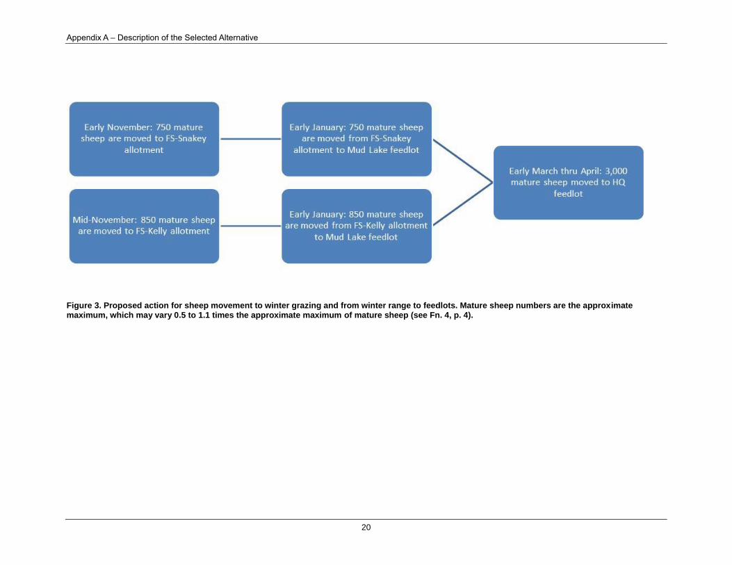
Figure 1 through Figure 3 demonstrate movement of sheep across Agricultural Research Service grazing
lands (Headquarters, Humphrey Ranch, Henninger Ranch, Summer East Range, and Summer West
Range) and Forest Service allotments (Beaver Creek, Meyers Creek, Snakey-Kelly [see Fn. 4, p. 4])
throughout a typical season. Table 1 displays annual sheep utilization of forage on Agricultural Research
Service and National Forest System lands. Grazing periods are approximated and relate to the
approximate time of the month (early, mid, late), which reflects variations from year to year due to

Record of Decision
17
weather and forage conditions (i.e., range readiness). In the figures and Table 1, mature sheep numbers
are an approximated maximum of 3,000; sheep numbers may range from 0.5 to 1.1 times the approximate
maximum in support of rangeland research and sheep research objectives. A mature sheep is a ewe or ram
that is sexually mature and retained as a part of the core breeding flock.

Appendix A – Description of the Selected Alternative
18
Figure 1. Proposed action for sheep movement out to spring and summer range. Mature sheep numbers are the approximate maximum, which may vary 0.5 to 1.1 times the approximate maximum of mature sheep.

Record of Decision
19
Figure 2. Proposed action for sheep movement from summer ranges to fall range. Mature sheep numbers are the approximate maximum, which may vary 0.5 to 1.1 times the approximate maximum of mature sheep.
Appendix A – Description of the Selected Alternative
20
Figure 3. Proposed action for sheep movement to winter grazing and from winter range to feedlots. Mature sheep numbers are the approximate maximum, which may vary 0.5 to 1.1 times the approximate maximum of mature sheep (see Fn. 4, p. 4).

Environmental Impact Statement
21
Sheep grazing periods and AUM5, for a typical year, are shown in Table 1, which is based on plant
productivity estimates from the last 15 years of sheep grazing data (Taylor 2015, personal
communication) and demonstrates the expected distribution of sheep AUM utilization. Animal unit
months are based on approximate grazing dates; actual grazing dates vary from year to year depending on
weather and plant conditions.
Table 1. Proposed action: Annual AUMa utilized per property within the grazing periods that are specified. The calculations are based on maximum of 3,000 sheep b (Taylor 2015, personal communication).
Properties AUM
Available AUM
Utilized Utilization Percent
Approximate Grazing Periods
Agricultural Research Service properties
48,667 3,625 8 percent
Headquarters 28,353 1,750 6 percent late April to early July;
late August to early December
Humphrey Ranch 4,476 800 18 percent early June to late October
Henninger Ranch 1,914 350 18 percent mid-June to mid-July;
late August to mid-September
East Summer Range (Toms Creek) c 4,043 225 6 percent mid-July to early September
West Summer Range (Odell Creek/ Big
Mountain) c
9,881 500 5 percent early July to early
September
Allotments on FS lands
22,709 712 3 percent
Snakey-Kelly c 1,756 440 25 percent early November to late
December
East Beaver 17,877 250 1 percent mid-June to late August
Meyers Creek d 3,076 22 1 percent mid-July; early September
a Animal Unit Month. By definition, one (1) AUM represents 790 lbs. of dry forage consumed over 30.44 days by a 1,000-lb cow that
is nursing a calf. Five (5) mature sheep (see footnote b immediately below) are equivalent to one (1) AUM.
b A mature sheep is any sexually-mature ewe or ram that that is retained as a part of the core breeding flock.
c Although the decision includes grazing the Forest Service Snakey-Kelly Allotments, these allotments will not be utilized (i.e., no
sheep grazing will occur) until the Forest Service authorizes use for sheep grazing (see Supplemental Information Report, http://www.ars.usda.gov/News/docs.htm?docid=17878).
d Unlike all other grazing properties, where rest rotations are conducted within property grazing subunits, rest rotation is applied to
the whole grazing units of West Summer Range (Odell and Big Mountain) and East Summer Range (Toms Creek). Rotations are two years of grazing and one-year rest (no grazing); therefore, annual AUM utilized are calculated as an annual average over three years, with one of the three years having a value of zero (the rest year). Grazing on FS-Meyers Creek allotment is always in conjunction with Agricultural Research Service -Toms Creek.
As mentioned previously, on Agricultural Research Service properties, sheep are limited so they remove
less than 10 percent on Headquarters, East Summer Range, and West Summer Ranges; and less than 20
percent on Humphrey Ranch and Henninger Ranch. For comparison, note that on neighboring National
Forest System and BLM properties, BLM and Forest Service allow other permittees that are grazing cattle
to remove up to 55 percent of annual forage growth. This means that Sheep Station grazing is at levels
well below generally accepted grazing practices on other federal lands.
5 Animal Unit Month. By definition, one (1) AUM represents 790 lb of dry forage consumed over 30.44 days by a
1,000-lb cow that is nursing a calf. Five (5) mature sheep (see footnote b immediately below) are equivalent to one
(1) AUM.

Appendix B – Project Maps
22
Infrastructure
Sheep Transportation by Truck
The sheep are trucked between grazing locations that are not contiguous or are not within trailing
distance. Sheep are trucked from Headquarters to the Mud Lake Feedlot, Humphrey Ranch, and to Forest
Service and Bureau of Land Management allotments (Table 2).
Table 2. The number of sheep trucked in and out each year for each range area and allotment
Property Sheep
Humphrey 650 rams and ewes
Winter Range (USDA FS Allotments) 2,100 ewes (± 100 depending on year)
10 rams
Mud Lake (DOE) 3,000 animals (± 1.1-fold at shearing and breeding
time)
There are permanent corrals and loading chutes at Headquarters, Mud Lake feedlot, Humphrey, and
Henninger. At the Snakey-Kelly allotments (see Fn. 4, p. 4), sheep are unloaded on Forest Service Road
202. Suitable roads and semi-truck and trailer access are available at the loading sites. Trucking occurs on
State Highways, County Roads, and National Forest system roads.
Headquarters and Mud Lake feedlot truck loading sites are similar in size and ground cover condition.
Both truck loading sites have permanent corrals with bare soil similar to sheep pens. The Headquarters
loading pen is 0.6 acre. The Mud Lake feedlot loading pen is 0.4 acre. The Humphrey and Henninger
Ranch sites are similar. The loading corral at Humphrey is 0.4 acre and Henninger loading corral is 0.8
acre. The Humphrey and Henninger loading sites have low vegetation ground cover.
Sheep Trailing Route Use and Maintenance
Trails are used to move sheep between and within grazing areas. These routes may be on roads (primitive,
gravel, paved) or historical livestock trails. Table 3 displays the annual trailing routes on roads that are
used by Sheep Station personnel (see also Map 2).
Table 3. Annual sheep trails
Trail Description
Headquarters to Henninger Ranch (21 miles; 2 days)
Sheep are trailed on an unnamed two-track road (2.5 miles), Clark County Road Spencer-Idmon (9.7 miles), and Clark County Road A2
(8.7 miles).
Henninger Ranch to FS-Meyers Creek allotment (11 miles)
Sheep are trailed on Clark County A2.
To/from Henninger Ranch and West Summer Range (9.4 miles)
Sheep are trailed on Clark County A2 (3.9 miles) and FS 327 (5.5 miles)
From East Summer Range to Henninger Ranch
Sheep are trailed on FS 042 (6.4 miles) and Clark County A2 (11 miles)
To/from FS-Snakey-Kelly a allotments (10 miles)
Sheep are trailed on FS 202, and along FS 184, 279 or 202.
a See Fn. 4, p. 4

Environmental Impact Statement
23
In timbered areas on East Summer Range and
West Summer Range, sheep are moved along
historical livestock trails (Figure 4). Herders
on horseback move sheep from one grazing
location to another. There are about four miles
of maintained sheep trails through timbered
areas on the East Summer Range and West
Summer Range, which are utilized as shown
in Table 4. Trail locations are shown on Map 9
and Map 10
Trails through timber patches are short,
generally less than 0.5 miles long. Annual trail
maintenance is conducted through the
timbered areas. Trees that fall across
driveways are moved off the driveways, and
some low-hanging limbs are removed. If
adverse effects to soil or water occur,
mitigation measures (e.g., cross drains with woody debris to divert overland flow) are implemented or a
trail segment may be rerouted to avoid sensitive areas. Unneeded or unused old driveways are closed and
rehabilitated by seeding with native species covering the trail with woody debris. Sheep are kept off these
restoration areas.
Table 4. Typical annual a number of sheep trailed on summer ranges based on a 3-yr average
Unit Length
(approx. miles) Use Time
(approx. hr.) Horse
Average count of
ewes with lambs a
West Summer Range a
Odell-Skyline Unit - used twice a year 1 2 2 533
Odell-Unit 6 - usually used once a year 0.13 1 2 533
Odell-Unit 4 - usually used twice a year
0.13 0.5 1 533
Odell-Little Odell - used once a year 0.25 1 1 533
Odell-Big Mountain -- used once a year
0.25 1 1 533
Big Mountain - generally used only once a year
0.25 1.5 2 533
Big Mountain-Corrals to Top - usually used 4 times a year
0.5 1.5 2 533
Big Mountain-Canyon Unit – used once or twice a year
1.4 0.8 2 533
East Summer Range a
Toms Creek-Units 5 & 6 – used once or twice a year
0.5 1.5 1 533
Toms Creek-Units 6 & 7 - used once or less a year
0.5 2 1 533
a Rest rotation is applied to the whole grazing units of West (Odell and Big Mountain) Summer Range and East (Toms Creek)
Summer Range. Rotations are two years of grazing and one-year rest (no grazing); therefore, annual AUM utilized are calculated as an annual average over three years, with one of the three years having a value of zero (the rest year). Grazing on FS-Meyers Creek allotment is always in conjunction with ARS-Toms Creek.
Figure 4. Sheep Driveway, Odell Creek

Appendix B – Project Maps
24
Maintenance and Repair of Fences
Pasture Fences
There are about 180 miles of pasture fence on Headquarters Range, Humphrey Ranch, and Henninger
Ranch. Fence locations, including exclosures, are shown on each pasture area (see Map 3 through Map 8).
Most fences are constructed with woven wire on the bottom and barbed-wire strands above.
All fences are inspected and repaired annually, which includes replacing decaying posts and wire and
removing non-functional fences and related materials.
Horse Corral Fence
A horse corral on the West Summer Range (Odell) pasture was constructed and is maintained to confine
horses used for sheep trailing, camp tending, and other sheep grazing management and research activities.
The corral is a drop fence, with all sides constructed with four strands barbed wire. The drop fence is let
down each year after grazing operations are complete.
Exclosure Fences
Exclosures on the Headquarters Range are sheep-proof fence, maintained to keep sheep from grazing
excluded areas. The West Summer Range exclosures are drop fences, put up to exclude sheep when sheep
grazing is being conducted. These drop fences are let down after sheep are removed from the pasture. At
this time, routine work that must be done to keep fences safe and fully functional will be conducted,
which includes replacing posts and wire.
Maintenance and repair of existing roads and fire lines
Roads
The Agricultural Research Service properties include a few miles of paved and gravel road and numerous
primitive roads (Table 5). Most secondary primitive roads are two-track with grass, forbs and low shrubs
between tracks (Figure 5 and Figure 6). No new roads have been developed in at least 15 years.
Table 5. Miles of road on Agricultural Research Service property
Property Miles of paved
road Miles of
gravel road Miles of
primitive road Notes
Headquarters 2 21 119
Humphrey Ranch - - 2.7
Henninger Ranch - - 1.5
East Summer Range - - 1 (closed) Closed and rehabilitated
West Summer Range
- - 0.8 Two-track used to access
horse corrals
Total 2 21 125
In the 1950s, the BLM authorized a private company to construct 7.8 miles of road on Summer West
Range to access a phosphate mine. Since then, the entire road has been closed, culverts pulled, fill in the
draw crossing excavated and drainage features restored. The road bed has grass, forb, shrub vegetation,
and conifer cover and is now used as a horse-riding and hiking trail. About one mile of primitive two-
track road to Blair Lake on East Summer Range is closed to motorized use and cross drains have been
constructed. Local roads (National Forest System; County) leading to property borders at Headquarters,
Humphrey Ranch, Henninger Ranch, and West Summer Range are locked and gated to prohibit

Environmental Impact Statement
25
unauthorized entry to these areas, where public motorized travel is prohibited. No new road construction
is planned.
Figure 5. Headquarters property displaying the firebreak and associated roads – See Map 5 appendix A
Figure 6. Example of road on Headquarters (sw 05/08)
Annual road maintenance and repair is conducted on main roads as needed. Each year approximately 20
miles of road needs maintenance. Road maintenance includes ongoing upkeep necessary to retain or
restore the road to approved management standards. Maintenance activities could involve cross drain
construction or surface drain installation, spot surfacing, minor culvert installation and replacement, catch
basin reshaping, road side brushing, cleaning and repair of existing cattle guards, and surface grading. All
replacement gravel is weed free and is hauled in from State of Idaho gravel pits. Road maintenance is
confined to the road right-of-way.
Permanent Firelines
A permanent firebreak (approximately, 14,000
feet) around the headquarters office and
housing area is maintained annually with a
motor grader to provide a mineral soil break
about 30 feet wide. Herbicides may be used to
control noxious weeds on the Headquarters
firebreak. Weed management is described in
the pest control section below.
Stock Water Operations In areas where water is not readily accessible
on Headquarters Range, water is trucked to the
sheep and unloaded into portable water
troughs (e.g., metal, fiberglass, or plastic) that
generally accommodate up to 12 mature sheep at one time. Troughs are equipped with ladders for birds to
escape. Troughs are moved as grazing progresses across the pastures; 80 watering sites are used on
Headquarters Range. To reduce hoof action around watering sites, they are generally used for four or less
days and then moved. Watering sites are approximately 0.25 acre and are dominated by bluebunch
Figure 7. Cleared firebreak –fy 2008

Appendix B – Project Maps
26
wheatgrass or crested wheatgrass. Henninger Ranch, Humphrey Ranch, West Summer Range and East
Summer Range have natural and developed surface water available.
Water Developments
Humphrey and Henninger Ranches
Irrigation was in place and ongoing before the Agricultural Research Service purchased the properties
from the private sector. Previous owners constructed ditches to divert creek water at registered (Idaho
Department of Water Resources) points-of-diversion onto grazing pastures. Currently, canvas dams are
placed in diversion ditches to flood pastures at the time sheep graze in the area, from Modoc Creek at
Humphrey Ranch and from West Dry Creek at Henninger Ranch. In accordance with the water district,
water may be diverted annually. The days and amount of water that is diverted varies annually and is
based on water availability as regulated by the water district. Approximately two miles of maintained
irrigation ditch exist at each ranch. Diversion ditches are inspected and maintained annually. Maintenance
includes cleaning with a tractor-drawn ditching implement or backhoe and improving points-of–diversion
(2 on Modoc Creek and 2 on Long Creek). In addition, site-specific planned improvements to water
developments at Humphrey Ranch may include:
installing two new weir boxes on Modoc Creek,
installing catch basins at 2 points-of-diversion along Long Creek, and
installing a temporary water storage tank.
West Summer Range
There are five water developments on Big
Mountain Unit of West Summer Range. Springs
are developed with permanent troughs to collect
water in low-flow areas needed to water up to
900 ewes with lambs (Figure 8). Water
developments are also used by wildlife. Four
developments are flume type, with metal
troughs and metal (3) or wood (1) support
structures. Flumes are 80 to 90 feet in length,
approximately 20 to 24 inches in width, and 14
to 16 inches deep. The fifth development is a
series of round rubber troughs, with about 10
gallons capacity each, installed at springs.
Troughs remain empty (plugs removed) when not in use. When in use, troughs are equipped with ladders
for birds to escape.
Developed water site locations include:
Short Canyon = SENE 1/4 Section 6, T15S, T1W (Round rubber troughs).
Lower Unit 3 = SENE Section 5, T15S, R1W (Flume trough).
Unit 2 = SWNWNW Section 5, T15S, R1W (Flume trough).
Upper Unit 3 = SESW Section 33, T14S, R1W (Flume trough).
Figure 8. Upland water trough (jf – 07/160/8)

Environmental Impact Statement
27
Unit 4 = NENESE Section 4, T15S, R1W (Flume trough).
Maintenance of water sites includes annual spring cleanings. Troughs are repaired when needed.
Camp Tending
Headquarters Range, Humphrey Ranch, and Henninger Ranch
Headquarters Range, Humphrey Ranch and
Henninger Ranch are administered from
existing roads. Herder camp trailers are 12-feet
long by 7-feet wide (Figure 9). A tow-behind
camp commissary is attached to securely store
dog food, oats, saddles, and other gear. These
camps are located near existing roads and are
moved with pickups as sheep graze through the
pastures. Camp activities affect less than 0.25
acre. Camp site equipment and activities
include a horse trough, a horse picketed on a
20- to 30-foot chain, and a dog feeding area.
Camps at Headquarters Range, Humphrey
Ranch, and Henninger Ranch are visited by a
camp tender every two or three days. Crested
wheatgrass and bluebunch wheatgrass provides
the primary ground cover at camp sites. Total area affected by camp sites is a negligible percentage of the
total pasture area. Trash from herders’ camps is transported back to the Headquarters office area for
proper disposal.
Summer Range
Summer camps include a 7 foot by 7-foot teepee tent. Horses are watered at natural water sites or
developments where sheep are watered; generally, one horse is picketed, and one horse is loose. Camp
areas affect about a 50-foot radius area. Camps are moved every three to four days as grazing progresses.
Camps follow the sheep closely and, with frequent moves, have little effect on vegetation at the sites.
Trash from herders’ camps is transported back to the Headquarters office area for proper disposal. Table 6
shows the number of camps in each summer range and season of use.
Table 6. Camps per pasture and season used on Summer Ranges
Range Pasture Camps per Pasture Season Used
West Summer Range Odell 9
early July to early September
Big Mountain 7
East Summer Range Toms Creek 6
Range Improvement
Wildfire Mitigation
To stop wildfires that threaten research study sites, sage grouse nesting and brooding habitat, and research
infrastructure, some fire lines are maintained for quick access and fire suppression. Fire lines that may be
Figure 9. Camp herder trailer

Appendix B – Project Maps
28
used are those that were developed for prescribed fires. Once fire lines recover from initial development
and a stable vegetation community is established, a combination of brush beating and herbicides may be
used to suppress excessive woody species growth. These fire lines are not used as roads and are only
accessed for maintenance (approximately once every 5 years) or fire suppression.
Prescribed Burning
As part of ongoing research activities, the Sheep Station burns portions of the Headquarters Range that
are required to test research hypotheses. The actual burned area over the past 30 years was 6,054 acres: 10
prescribed burns totaling 4,616 acres and 4 wildfires totaling 1,437 acres. Past prescribed burns ranged
from 226 to 758 acres in size (see Map 4).
Over the next five years, several small experimental prescribed burns are planned on the Headquarters
Range. Generalized locations for each burn unit are shown in Map 5 and they include:
Three burns would occur with largest being 275 acres and totaling a maximum of approximately 700
acres over five years (Map 5). These prescribed fires will be in conjunction with a shrub management
study, described further below. The prescribed fires serve two objectives: (1) to validate post-fire
vegetation recovery models, and (2) to reduce woody fuel loads on small strips of land to mitigate
catastrophic wildfire that threaten large, intact areas of sage grouse habitat.
Prescribed burns in pastures 6, 7, and 8, to be followed by revegetation (see below).
30-meter by 30-meter plots in Headquarters exclosures would be burned, treated with biochar, and re-
seeded (see below).
Prior to burning, a burn plan is prepared. For experimental prescribed burns, temporary graded fire lines
(approximately 15 feet wide) are constructed around prescribed burn areas. Temporary fire lines are
constructed with a dozer and motor grader. Fire lines are used for vehicle and equipment access during
burn operations and for research during and after the areas are burned. Once the fire line is no longer
needed, shrub and grass debris are pulled back and spread over the cleared area, which generally occurs
within one year of the burn.
Firelines around prescribed burn areas are allowed to recover. Some fire lines may be managed to
mitigate wildfire risk, which involves brush beating or herbicide treatment (see Range Improvement,
Wildfire Mitigation). Generally, fire lines revegetate with native species within one or two seasons after
the burn. Invasive noxious weeds have not been a problem on the cleared firebreaks. Bromus tectorum L.,
present since 1930s, is an incidental species on the Headquarters Range, but is not persistent at this
elevation or in this environment.
Shrub Management Using Herbicides
As part of experimental practices on the Headquarters property, herbicides may be used to manage
vegetation for both fuel reduction and wildlife habitat purposes. These treatments would be used to
protect and enhance healthy sagebrush ecosystems. Over the next five years, three experimental
applications of herbicide treatments are planned on the Headquarters property (see Map 5). These
herbicide treatments will be in conjunction with a prescribed burn study, which is described in the section
above, “Prescribed Burning.” The herbicide treatments serve four objectives:
(1) Investigate post-herbicide vegetation recovery,
(2) evaluate effectiveness of herbicide treated strips of rangeland to curtail wildfire advancement,

Environmental Impact Statement
29
(3) reduce volatile woody fuel loads on small strips of land to mitigate catastrophic wildfire that threaten
large, intact areas of sage grouse habitat, and
(4) determine the effectiveness of various test herbicides to reduce P. tridentata presence in old sagebrush
stands where sagebrush is decreasing and P. tridentata is increasing.
The treatments would include primarily aerial application of herbicides to reduce shrub density (i.e.,
volatile fuel loads) along long narrow strips through shrub-dense areas. In addition, strategic spot
treatments may be used in these areas to further curtail bitterbrush domination stands that were formerly
dominated by sagebrush stands. The treatments will be followed by the prescribed burning described
above. It is anticipated that these narrow strips will reduce the likelihood that wildfires would advance at
an uncontrolled and destructive rate through contiguous shrub-dense habitats for sage grouse. Herbicide
treatments would target the following species sagebrush and bitterbrush species: Artemisia tridentata
Nutt. subsp. vaseyana (Rydb.) Beetle; Artemisia tripartita Rydb. subsp. tripartita; Purshia tridentata
(Pursh) DC. The herbicide that would be recommended for use is tebuthiuron (a granular formula). All
application would occur according to label specifications and would be conducted consistent with the
herbicide application protocols in Appendix C. Generalized locations for each treated unit are presented
in Map 5. Six herbicide applications would occur with largest being 73 acres and totaling a maximum of
about 375 acres over five years
Seeding
Range improvement activities also include seeding of test plant products for experimental evaluation. In
some cases, if sites are infested with invasive species, they would be treated with herbicide application
prior to seeding. All herbicide application would occur according to label specifications and would be
conducted consistent with the herbicide application protocols in Appendix C. The following specific
seeding activities are proposed for the Headquarters Range and Humphrey Ranch within the next five
years:
Revegetate historical gravel pit in Pasture 4U/1U - Entire area (~52 acres) would be seeded to a mix
of Purshia tridentata (Pursh) DC., Bassia prostrata (L.) A.J. Scott, and Agropyron cristatum (L.)
Gaertn. to evaluate site stabilization and rehabilitation of an abandoned barrow pit.
Revegetation after fire in pastures 6, 7, and 8 - A portion of the burned area would be seeded to novel
varieties of B. prostrata to evaluate performance in sagebrush-steppe conditions.
Revegetation after fire and biochar application in Headquarters exclosures.
Renovate improved pastures at Humphrey – Portion of the area (~10 acres per year; see Map 8) is
periodically reseeded to restore to former vegetative composition. Common plants that are seeded
include Dactylis glomerata L., Phleum L., and Bromus biebersteinii Roem. & Schult., Medicago L.,
and Trifolium pratense L.
Integrated Pest Management
There are some invasive plant populations on Agricultural Research Service properties. These species
become established along roads, where seeds are transported by vehicles, and populations persist where
there is no sheep grazing. Sheep grazing tends to prevent many weeds from becoming established. Some
weed species have spread over time on to Agricultural Research Service properties from adjacent lands
where cattle graze. Weed locations are recorded on maps as they are found. Invasive plant species
infestations are GPS (Global Positioning System) mapped and are targeted for treatment.

Appendix B – Project Maps
30
An adaptive management/integrated pest management approach is used to control and eradicate exotic,
invasive weeds. This integrated approach is coupled with research on ecosystem functions and native
plant communities. As primary weed control, this integrated approach includes the use of strategic sheep
grazing as a biocontrol method to reduce the production of weed seed and spread of weeds and utilizes
targeted herbicide treatments where sheep grazing is ineffective. In addition, specific beetle species are
used for biocontrol, alone or in combination with grazing.
Strategic Sheep Grazing
Precautions are taken to minimize weed spread by sheep grazing. Areas with weeds are grazed in spring
when there is little or no risk of spreading weed seeds. Noxious weeds are not grazed when weed seeds
are developed and there is risk of spreading viable seeds to other areas. If necessary, animals are
quarantined for six days before moving sheep from weed infested areas or from feed with potential weed
seeds to other grazing units.
To control Euphorbia esula (L.) and Centaurea stoebe (L.), grazing is conducted in spring or early
summer when there is no or little risk of spreading weed seeds. Sometimes herbicides are used on
invasive weed species that are not consumed by sheep.
Herbicide Application
Herbicides are sprayed semiannually along some roads and in sheep pens where invasive weeds are
present. Herbicides have been used to control weeds along roadsides, in feedlots and corrals, small
pastures (less than 25 acres), and near building structures for about 30 years. In small confined
infestations, herbicide use is more effective on weeds than sheep grazing. For noxious weed management,
herbicides application methods include:
Spot treatment and hand-wand application control weeds along roadsides, in feedlots and corrals, and
near building structures.
Four-wheeler-mounted and tractor-mounted boom-sprayer application is conducted to control weeds
in small pastures and in large feedlots.
Approximately 90 percent of the application is along roadsides.
Herbicides are also used to control E. esula, C. stoebe, B. tectorum, Cardaria draba (L.) Desv.,
Chenopodium album L., Bassia scoparia (L.) A.J. Scott, Cirsium spp. Occasional herbicide control is
conducted for rare sightings of Hyoscyamus niger L., Arctium lappa L., Isatis tinctoria L., Hieracium
cynoglossoides (Arv.-Touv) P.
Herbicides used to control weeds include, but are not limited to: clopyralid, triclopyr amine, imazapyr,
diuron, picloram, bromacil, non-aquatic glyphosate, 2,4-D amine, and imazapic. Historically, herbicides
are applied to less than 60 acres annually. All application would occur according to label specifications
and would be conducted consistent with the herbicide application protocols in Appendix C.
Cattle and Horse Grazing Periodically, cattle and limited horse grazing is used with cooperative research to achieve research
grazing objectives in years when the sheep do not remove enough forage. Cattle and horses consume
vegetation that sheep typically do not harvest, create more uniform pastures for grazing research, reduce
residual on-site forage for other rangeland research, and reduce fuel loads and fire risk. Cattle and horse
grazing is used mainly on the Headquarters Range and Humphrey Ranch, with less frequent cattle and
horse grazing at Henninger Ranch. The number of animals used varies from year to year depending on
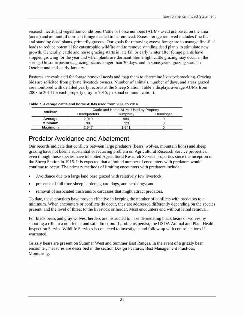
Environmental Impact Statement
31
research needs and vegetation conditions. Cattle or horse numbers (AUMs used) are based on the area
(acres) and amount of dormant forage needed to be removed. Excess forage removed includes fine fuels
and standing dead plants, primarily grasses. Our goals for removing excess forage are to manage fine-fuel
loads to reduce potential for catastrophic wildfire and to remove standing dead plants to stimulate new
growth. Generally, cattle and horse grazing starts in late fall or early winter after forage plants have
stopped growing for the year and when plants are dormant. Some light cattle grazing may occur in the
spring. On some pastures, grazing occurs longer than 30 days, and in some years, grazing starts in
October and ends early January.
Pastures are evaluated for forage removal needs and map them to determine livestock stocking. Grazing
bids are solicited from private livestock owners. Number of animals, number of days, and areas grazed
are monitored with detailed yearly records at the Sheep Station. Table 7 displays average AUMs from
2008 to 2014 for each property (Taylor 2015, personal communication).
Table 7. Average cattle and horse AUMs used from 2008 to 2014
Attribute Cattle and Horse AUMs Used by Property
Headquarters Humphrey Henninger
Average 2,010 984 0
Minimum 786 723 0
Maximum 2,947 1,541 0
Predator Avoidance and Abatement Our records indicate that conflicts between large predators (bears, wolves, mountain lions) and sheep
grazing have not been a substantial or recurring problem on Agricultural Research Service properties,
even though those species have inhabited Agricultural Research Service properties since the inception of
the Sheep Station in 1915. It is expected that a limited number of encounters with predators would
continue to occur. The primary methods of limiting encounters with predators include:
Avoidance due to a large land base grazed with relatively few livestock;
presence of full time sheep herders, guard dogs, and herd dogs; and
removal of associated trash and/or carcasses that might attract predators.
To date, these practices have proven effective in keeping the number of conflicts with predators to a
minimum. When encounters or conflicts do occur, they are addressed differently depending on the species
present, and the level of threat to the livestock or herder. Most encounters end without lethal removal.
For black bears and gray wolves, herders are instructed to haze depredating black bears or wolves by
shooting a rifle in a non-lethal and safe direction. If problems persist, the USDA Animal and Plant Health
Inspection Service Wildlife Services is contacted to investigate and follow up with control actions if
warranted.
Grizzly bears are present on Summer West and Summer East Ranges. In the event of a grizzly bear
encounter, measures are described in the section Design Features, Best Management Practices,
Monitoring.

Appendix B – Project Maps
32
Design Features, Best Management Practices, Monitoring
Wildlife Conservation Measures (Grizzly Bear)
Sheep Station personnel, including herders, implement a number of conservation measures to reduce the
likelihood of potential conflicts between predators, such as grizzly bears and domestic sheep/livestock.
The following conservation measures were extracted from the U.S. Fish and Wildlife Service Biological
Opinion (01EIFW00-2015-F-0275; February 25, 2015) for U.S. Sheep Experiment Station Grazing
Program Agricultural Research Services:
“The proposed action includes nondiscretionary avoidance and minimization measures that
[the Sheep Station] will implement to reduce potential adverse effects to grizzly bears. The
US Fish and Wildlife Service and the Agricultural Research Service worked closely to
develop these measures. Additional best practices and more details on the below are
described in the Assessment (p. 11-13) and are incorporated here by reference. The
Agricultural Research Service and its employees will implement the following measures
during grazing operations:
When creating research plans that include sheep grazing, the Agricultural Research
Service will consider the history of livestock-bear conflicts on Agricultural Research
Service lands. If recurring conflicts develop, the Sheep Station will modify the
grazing schedule and/or sheep movements to avoid additional conflicts.
The Sheep Station will use good husbandry practices so that sheep are as healthy as
possible, are suitable for research, and the number sick or stray animals is kept to a
minimum. An institutional animal care and use committee will evaluate research
protocols and livestock management practices to ensure they are consistent with good
animal husbandry, and comply with federal laws that govern the use of agricultural
animals in research. Protocols and practices that do not comply are not approved.
Sheepherders, working dogs, and guard dogs will be kept with the sheep full-time
when on rangelands to reduce the likelihood of conflicts or encounters with grizzly
bears, and to assist in efficient and prompt movement of animals when necessary. In
the Summer Range, sheep are accompanied by a minimum of two guard dogs, two
herd dogs, and a full-time sheepherder.
Sheep will be bedded in the evenings on an approximately 1-acre area. On moonlit
nights, when sheep have the tendency to get up and graze, sheepherders will exercise
extra vigilance.
Lame livestock, which may occur occasionally, will be watched closely. When lame
animals do not recover, they will be removed from the herd within a short period of
time (approximately every 3 days when the camp tender brings supplies), and
transported back to the Headquarters property.
All unnatural attractants to bears will be minimized. This includes treatment or
removal of livestock carcasses, and proper storage of human foods, garbage, and dog
food. Approved bear-proof containers will be used. Damaged containers will be
repaired or replaced promptly so that they work as designed. Camp tenders and
managers will make periodic visits (approximately every three days) to remove trash
and animal carcasses to eliminate potential bear attractants.

Environmental Impact Statement
33
At least two formal training-orientation meetings will be conducted annually with
Sheep Station employees and herders to review identification of grizzly bear and
other wildlife. Sanitation and garbage removal practices, nonlethal procedures to
address livestock-wildlife encounters, and who to contact should encounters occur
will be discussed at these meetings.
Herders will be instructed to avoid encounters with grizzly bears. Herders may move
sheep to other areas of the pasture to avoid an immediate threat. Moving sheep to
other pastures or locations will occur if encounters persist. For the purposes of this
Opinion, grizzly bear-human encounters encompass any interaction between a grizzly
bear and a human, from sightings to altercations that result in the death or injury of
either the bear or the human.
Herders will report all bear sightings to their supervisor. When on Agricultural
Research Service land, all existing and suspected bear activity and (or) conflicts will
be reported directly to Animal and Plant Health Inspection Service (APHIS), Wildlife
Services. APHIS Wildlife Services would then contact state and federal agencies as
necessary to conduct damage investigations. When on National Forest System lands,
all existing and suspected bear activity and (or) conflicts will be reported directly to
US Forest Service contacts as well as APHIS Wildlife Services. Department of
Energy-administered land is outside of the current range of grizzly bears and outside
of suitable grizzly bear habitat, so a reporting protocol for grizzly bears is not
proposed for these lands.
All sightings that are confirmed grizzly bears, or positive evidence of grizzly bear
near livestock, will be reported by the Sheep Station to the Interagency Grizzly Bear
Study Team within one week.
In an interagency agreement with the USDA Forest Service (USDA Forest Service
2007), the Sheep Station agrees to comply with grizzly bear management goals on
the Meyers Creek and East Beaver Allotments (as described in USDA Forest Service
2004, p.6) including notifying appropriate personnel of grizzly bear conflicts or
encounters, and temporarily stopping or modifying grazing as necessary, should bear
encounters arise with humans or livestock. This agreement may be updated based on
future consultation between the USDA Forest Service and the US Fish and Wildlife
Service regarding livestock use of the Meyers Creek Allotment.”
Grizzly bear trapping, transportation, or lethal removal is not part of the proposed action. Thus, if needed,
it would require additional consultation with the U.S. Fish and Wildlife Service. Other reasonable and
prudent measures may be developed as formal consultation with the U.S. Fish and Wildlife Service
proceeds.
Bighorn Sheep
Measures are in place to minimize contacts between wild and domestic sheep, with specific regard to the
Forest Service Snakey-Kelly allotments (see Fn. 4, p. 4), where such contact is a possibility. These
measures include the full-time presence of herders and guard dogs and daily early morning and late
evening patrolling and scanning, with binoculars/spotting scopes, of the planned grazing-area perimeters.
In the event bighorn sheep are spotted, whether nearby or far off, herders will immediately contact
Agricultural Research Service supervisors, and Agricultural Research Service supervisors will
immediately contact the Idaho Fish and Game, first, then the Forest Service District Ranger and await
Appendix B – Project Maps
34
instructions. In the meantime, herders will monitor the movement of the bighorn sheep and record the day
and time of event, location, number and sex of sheep, and approximate distance of the bighorn sheep from
the domestic sheep. This information will be reported immediately to Agricultural Research Service
supervisors, Idaho Fish and Game Supervisors, and U.S. Forest Service District Ranger. The Sheep
Station will comply with any immediate requests of the Idaho Fish and Game.
Road to Blair Lake
Mitigation to reduce and prevent erosion are needed on this road from where it crosses on to Agricultural
Research Service property to where the road ends, near Blair Lake. Mitigation measures are as follows:
Blair Lake M1: Increase signage and off-trail deterrents (dropped trees) to discourage trespass on
the historically closed road.
Blair Lake M2: From crest of hill down to first meadows): Rills and gullies are starting to develop
on the compacted road surface. Install water bars at the first gradient breaks to get the water off the
road. Install subsequent water bars at gradient breaks until the open meadows are reached. Extend
water bar at least six feet into adjacent hillside along contour or at a slight angle to the slopes
gradient. Hand crews would be used to implement the recommended measures. Knock rut edges
down, and fill in ruts. Place small diameter (four inches or less) brush consistently over the length
of the ruts to slow any surface runoff and encourage deposition of fine grained sediment.
Deposition of fine-grained sediment would provide the opportunity for revegetation from adjacent
sources. If vegetation is not established within three years consider reseeding.
Blair Lake M3: From first meadows to major slope break above where road ends: Install water bars
at noticeable gradient breaks on ruts and road. Extend water bars at least six feet into adjacent
hillside along contour or at a slight angle to the slope gradient. Place small diameter (four inches or
less) brush consistently over the length of the ruts to slow any surface runoff and encourage
deposition of fine-grained sediment. Deposition of fine-grained sediment would provide the
opportunity for revegetation from adjacent sources. If vegetation is not established within three
years consider reseeding.
Blair Lake M4: From major slope break to where road ends: Install water bars at noticeable
gradient breaks on ruts and road to eliminate surface runoff from road. Extend water bars at least 6
feet into adjacent hillside along contour or at a slight angle to the slope gradient. Place small
diameter (4 inches or less) brush consistently over the length of the ruts to slow any surface runoff
and encourage deposition of fine grained sediment. Deposition of fine grained sediment would
provide the opportunity for re-vegetation from adjacent sources. If vegetation is not established
within three years consider re-seeding.
Blair Lake M5: At road end: Harden the sheep driveway across the stream (to minimize sediment
input into stream) with gravel and small cobbles from surrounding area. In addition, harden the last
30 to 50 feet of the road and place a water bar at the road end to divert surface runoff. This would
minimize or eliminate surface runoff and sediment from entering the creek at the road end.
Sheep Crossings
The following mitigation will be implemented at sheep crossings at points OD 4 and OD 5, on the North
and South Forks of Odell Creek. At the North Fork Creek (OD 4 T15S, R2W, Section 11, SW ¼) these
mitigations apply to the main and secondary crossings.
North Fork of Odell Creek M6: At both crossings place water bars at key gradient breaks or embed
12-inch logs at this gradient breaks about 4-5 inches deep, and at an angle of 20-45 degrees across

Environmental Impact Statement
35
the driveway to ensure water is diverted off this area into undisturbed vegetated forest floor, which
would function as a sediment filter strip.
North Fork of Odell Creek M7: At the secondary and smaller crossing, harden the stream banks
with rock, small logs, pole sized timber, or other locally obtained native material (that can harden
stream banks) to prevent further degradation due to sheep crossing the stream.
South Fork of Odell Creek (OD 5 T15S, R2W, Section 14, SW ¼) M8: The far side of the crossing
comes out on to a steep slope, which is largely bare of vegetation. Currently, there are no signs of
rilling or gullying, but mitigation will prevent further degradation due to sheep crossing the stream.
South Fork of Odell Creek M9: Harden the far bank with small rock to provide soil cover or
consider developing an alternative crossing nearby where the entry and exit would not lend its self
to slope issues.
Heritage
To ensure protection for cultural resources:
A Heritage Management Plan outline (appendix D) has been compiled to ensure the protection of
cultural resources. The foundation of this outline is three-fold: to comply with Section 106 of the
National Historic Preservation act, record and provide management guidelines for Sheep Station
historic properties, and develop and implement a survey strategy for the Agricultural Research
Service, Sheep Station, Dubois, Idaho, properties.
If unanticipated discoveries are found during project activities, cease all operations near the
discovery until assessed by a professional archaeologist or historian.
Best Management Practices
Best management practices would be implemented for herbicide application, grazing and stream
crossings. Best management practices have been proven effective across the country in managing non-
point sources of pollution, and their implementation is required in both Idaho and Montana as part of the
Clean Water Act (Seyedbagheri 1996, Schuler and Briggs 2000, USDA Forest Service 2002)
Best Management Practices for Herbicides
A contingency plan, or emergency spill plan, identifies notification requirements, time requirements for
notification, spill management, and parties responsible for cleanup. Factors to be considered during spill
cleanup are the substance spilled, the quantity, and toxicity, proximity to waters and hazard to life,
property, and environment, including aquatic organisms.
During pesticide application, an untreated buffer will be left alongside surface waters, wetlands and
riparian areas. In determining buffer width, the following factors may be taken into consideration:
beneficial water uses, adjacent land use, rainfall, temperature, wind speed and direction, terrain, soils,
vegetative type and aquatic life. Other considerations are: the type of application, persistence on-site,
foliage, spray pattern and droplets and carrier. Table 8 displays the buffer widths used during the
application of herbicide.

Appendix B – Project Maps
36
Table 8. Summary of buffer widths by herbicide
Herbicide Recommended
Buffer Width Comment
2, 4 D 25 feet a
Most formulations of 2,4-D do not bind tightly with soils and, therefore, have the potential to leach down into the soil column and to move off-site in surface or subsurface
water flowsb. .
Imazapyr Up to edgeb Low toxicity to fish and algae; Mobility pH dependent;
Picloram 25 feeta
164 feet
Known surface and groundwater contaminant; 25-foot buffer applies to surface water drainages; 164-foot buffer
applies if herbicide applied near Station groundwater wells
Bromacil 25 feeta
164 feet
Known groundwater contaminant; 25-foot buffer applies to surface water drainages; 164-foot buffer applies if herbicide applied near Station groundwater wells
Clopyralid 25 feeta
164 feet
Considered moderately toxic to fish; 25-foot buffer applies to surface water drainages; 164-foot buffer applies if
herbicide applied near Station groundwater wells
Triclopyr Up to edgeb The water-soluble salt is degraded in the water column through photolysis and hydrolysisb
Diuron 25 feeta
164 feet
Known groundwater contaminant; Moderately toxic to fish and highly toxic to aquatic plants; 25-foot buffer applies to
surface water drainages; 164-foot buffer applies if herbicide applied near Station groundwater wells
Non-aquatic glyphosate
100 feet Relatively low toxicity to birds, mammals and fish.
Aminopyralid 0 feet c
Given its high mobility, and moderate persistence in soil, aminopyralid is likely to leach to ground water irrespective
of soil type; slightly non-toxic (or a low potential for adverse effects) to fish and aquatic organisms d
Tebuthiuron 100 feetd A minimum buffer zone of 100 feet wide will be provided
for aerial application.
a - Bonneville Power Administration, Date Unknown, Transmission System Management Program (DOE/EIS-0285)-Final EIS, Chapter 5;
b - Tu et al, Nature Conservancy Weed Management Handbook
c - Durkin, 2007 Risk Assessment for U.S. Forest Service
d - Thornton, 2011e Bureau of Land Management 2010
Monitoring
Ongoing range management and research includes monitoring conditions on lands used by the Sheep
Station. To help inform our management activities the following monitoring occurs:
Monitoring vegetation and soil on lands and research sites using modern remote-sensing and
historical on-the-ground measurements.
Identifying and assessing invasive and noxious weeds and trespass-traffic.
Assessing AUM availability and harvest.
Monitoring sage grouse use of historical and newly established lek sites.
Monitoring other wildlife.

Environmental Impact Statement
37
Monitoring of design criteria
In addition to ongoing research-related monitoring, the effectiveness of design criteria at the sheep
crossings and road to Blair Lake will be monitored. Areas will be inspected after high precipitation events
and at the beginning of each season of use. Maintenance work will be conducted as needed, based on
inspections. Establishing key photo points will occur for annual monitoring purposes and summarizing
recovery conditions. If needed, additional work to enhance restoration will continue.
With regard to herbicide use, water quality in primary and auxiliary domestic water wells will be
monitored on the Headquarters property. A long-term monitoring plan will be developed only if water
quality concerns are identified during the screening phase of monitoring.

Appendix B – Project Maps
38
Appendix B - Project Maps
Map 1. Vicinity map

Record of Decision
39
Map 2. Proposed Action (alternative 1) overview with allotments and sheep trails (see Fn. 4, p. 4)

Appendix B – Project Maps
40
Map 3. Headquarters pasture overview

Record of Decision
41
Map 4. Headquarters wildfire history

Appendix B – Project Maps
42
Map 5. Headquarters proposed treatments
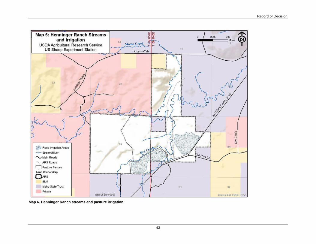
Record of Decision
43
Map 6. Henninger Ranch streams and pasture irrigation

Appendix B – Project Maps
44
Map 7. Humphrey Ranch streams and irrigation

Record of Decision
45
Map 8. Humphrey Ranch proposed seeding

Appendix B – Project Maps
46
Map 9. East Summer Range streams, sheep trails, and features

Record of Decision
47
Map 10. West Summer Range streams, sheep trails, and features

Appendix B – Project Maps
48
Map 11. Department of Energy Mud Lake Feedlot

Record of Decision
49
Map 12. Alternative 2 overview

Appendix B – Project Maps
50
Map 13. Alternative 3 overview (see Fn. 4, p. 4)
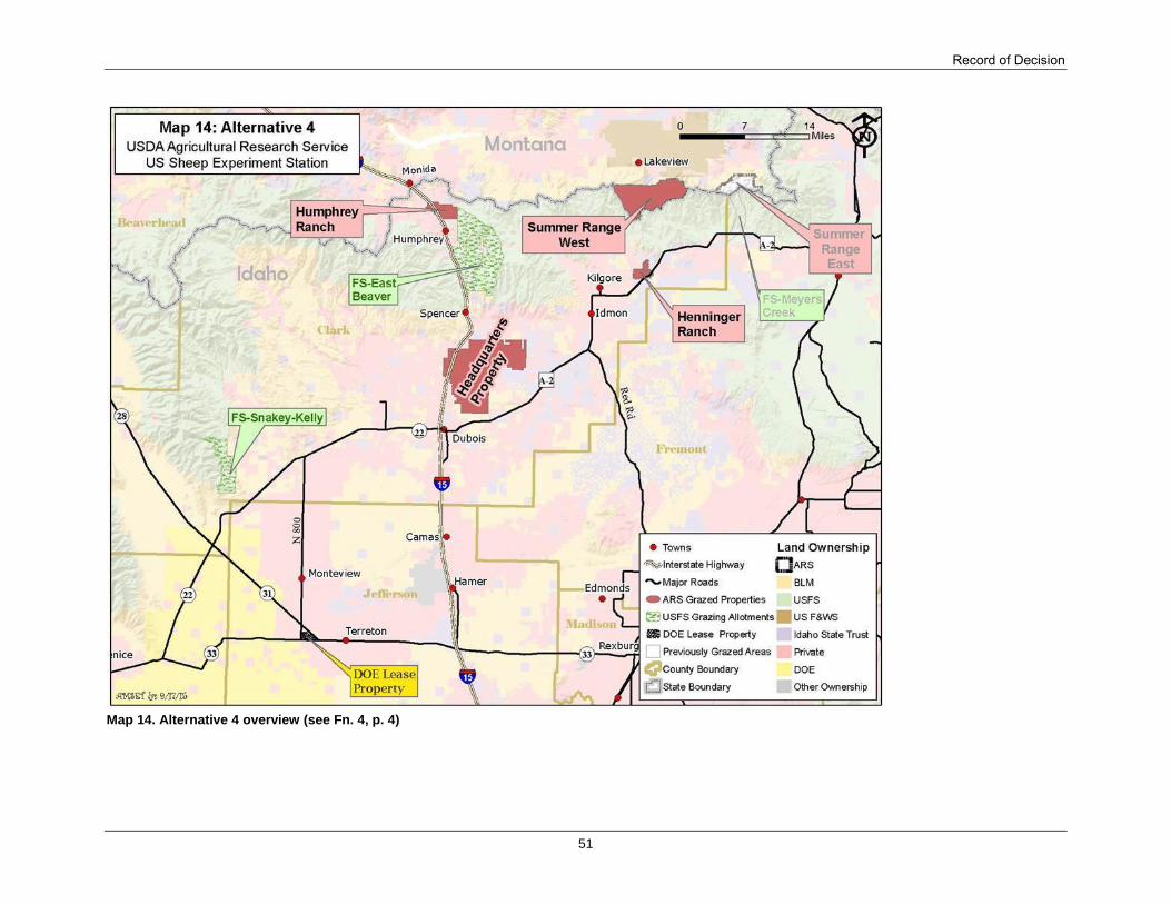
Record of Decision
51
Map 14. Alternative 4 overview (see Fn. 4, p. 4)

Appendix B – Project Maps
52
Map 15. Alternative 5 overview

Record of Decision
53
Appendix C – Errata for the Final Environmental Impact Statement In preparation of this record of decision, the following errors or points-of-clarification were
identified in the Final Environmental Impact Statement and are corrected as described below:
FEIS, page 57, subsection Draft Environmental Impact Statement 2011 Comment Period,
second paragraph, the last two sentences state, “However, a detailed response to
comments has not been prepared at this time. Pursuant to 40 CFR 1503.49(a), a response
to all of the comments received will be prepared and published with the FEIS.” In
preparation of the FEIS, this sentence was not updated to reflect that the comments were
addressed and included in the FEIS, Appendix F. Therefore, the two sentences are
replaced with, “A detailed response to comments was prepared and published in
Appendix F.”
FEIS, page 143, subsection Bighorn Sheep (Ovis canadensis canadensis), first paragraph,
the last sentence states, “Two small herds form prior bighorn sheep reintroductions are
present in the Upper Snake region of Idaho near the Forest Service Snakey-Kelly
Allotments.” This statement could not be verified by Idaho Fish and Game. Therefore,
the sentence is replaced with, “Bighorn sheep are present in the Upper Snake region of
Idaho near the Forest Service Snakey-Kelly Allotments, which are described in Forest
Service Grazing Allotments (Snakey-Kelly), page 147.”
FEIS, page 145, subsection ARS Properties, first paragraph, second sentence: Delete
“California” and replace with “Rocky Mountain.” The incorrect subspecies of bighorn
sheep was stated.
FEIS, page 148, subsection Forest Service Grazing Allotments (Snakey-Kelly) continued
from p. 147, first full paragraph immediately before section Bighorn Sheep Direct and
Indirect Effects, the second to the last sentence states, “This information will be reported
immediately to ARS supervisors and the Forest Service District Ranger.” The Idaho Fish
and Game was inadvertently not included in the contact chain. Therefore, the sentence is
replaced with, “All bighorn sheep sightings will be immediately communicated to the
Sheep Station office, and the Sheep Station will immediately contact the Idaho Fish and
Game, first, then the Forest Service District Ranger.”
FEIS, page 149, subsection Bighorn Sheep Cumulative Effects, second bullet set, the first
bullet states, “Grazing Sheep Station sheep on Forest service lands has only a minimal
risk of contact between bighorn sheep and domestic sheep because of geographic and
temporal separation.” The statement does not clarify the potential for direct contact.
Therefore, the sentence is replaced with, “The resident bighorn herd could be negatively
affected if contact with domestic sheep results in disease transmission. However,
measures are in place to minimize the risk of contact between domestic and bighorn
sheep.”
FEIS, page 161, subsection Sage-grouse Direct and Indirect Effects, Modified Alternative
1, first paragraph, third sentence: Delete “+” and “by avoiding leks, known nesting areas,
and known early brood-rearing areas” and adjust the sentence to read, “From mid-April
through mid-June, approximately 3,300 (includes lambs) sheep would be grazing the
Headquarters pastures. Although this could affect sage-grouse breeding, nesting, and

Appendix B – Project Maps
54
early brood-rearing activity, conservation measures are in place that would minimize
impacts and interactions of sheep with sage-grouse by implementing short duration and
rest-rotation grazing practices.”
FEIS, page 218, section Socioeconomic Summary, first paragraph, first sentence: Delete
“the 13th largest” and replace with “a major”. The sentence should read, “The Sheep
Station is a major employer in Clark County and thus it provides important economic
contributions to local businesses and public services.”
FEIS page 323, Table 45, correspondence ID 146: The Name column should include both
Glenn Hockett and John Meyer; the Affiliation column should include both Gallatin
Wildlife Association and Cottonwood Environmental Law Center.
FEIS, page 416, Table 46, Commenter Number 24, Author Oakey, Brian: In the
Organization of Affiliation column, change “Idaho Department of Fish and Game” to
“Idaho State Department of Agriculture.”
FEIS, page 416, Table 46, Commenter Number 25, Author Bregory, Beardslee: In the
Organization of Affiliation column, add “Idaho Department of Fish and Game.”