Read the Adobe Walls Brochure
6
^ S&MX^ HUTCHINSON COUNTY HISTORICAL MUSEUM (806) 273-0130 • 618 N. Main • Borger, Texas 79007 www.hutchinsoncountymuseum.org • E-mail: [email protected] v:•«V: tf-}*}•//¥ «»'. '•' »*••':V«( V: •'•• • l^^^lfes ^VIJ^^\^vfe^^5*«V<i^. ^;^^^l^^fe^^, ^^^;|^-^|||^te ''''•'^fe'' TEXAS PLAINS TRAIL TEXAS HISTORICAL COMMISSION! TEXAS HERITA8E TRAILS PROGFU -^™^ - ^i^ Funded by the Hotel Occupancy Tax and Friends of the Museum. See our ad in the Fiest Yellow Book.
Transcript of Read the Adobe Walls Brochure

^S&MX^
HUTCHINSON COUNTY HISTORICAL MUSEUM(806) 273-0130 • 618 N. Main • Borger, Texas 79007
www.hutchinsoncountymuseum.org • E-mail: [email protected]
v:•«V:tf-}*}•//¥ «»'. '•' »*••':V«(V:•'•• •l ^ lfes^VIJ^^\^vfe^^5*«V<i .
; ^ l fe^ ,^ ;| - ||| te
''''•' fe''
TEXASPLAINSTRAIL
T E X A S H I S T O R I C A L COMMISSION!TEXAS H E R I T A 8 E TRAILS PROGFU
- ™^ - i
Funded by the Hotel Occupancy Tax and Friends of the Museum. See our ad in the Fiest Yellow Book.

Adobe WallsNestled in the prairies and plains of the Texas Panhandle
is Adobe Walls, the site of two notable conflicts between thenative Plains Indians and the white men. The existence of theComanches and the Kiowas gives Adobe Walls its historicalsignficance.
It was theirs before it was ours. The transition of itsstewardship is filled with harrowing tales of thundering buffalo,broken treaties and desperate fighting.
The first battle involved Christopher (Kit) Carson, wholed United States troops to the protection of the ruins of FortAdobe when a band of Kiowa and Comanche Indians metthem, ready to fight. More than 60 warriors were killed in whatwas called "Kit Carson's last fight."
Settlers were seeking safe passage through the Plains as theytraveled west along the Santa Fe Trail and other treacherousroutes. Many were seeking refuge from the ravages of theongoing Civil War.
Because of the war, the Army was spread thin along theTexas-New Mexico frontier. A fear had spread among the whitesthat the Southern Plains Indians - the Comanche, Kiowa,Arapaho and Cheyenne — might be forming an alliance withthe mountain tribes consisting of the Utes and Jicarilla Apache.There was little the Army could do and a pre-emptive attack bythe military was planned.
Carson was ordered to enlist the Utes and Jicarilla Apachesin a campaign across the Plains with a strategy that if thetribes were pitted against each other, they could never form asignificance alliance. Carson left Fort Bascom on the CanadianRiver and began his 200 mile journey. He had with him, 14officers, 321 enlisted men and 75 Ute and Jicarilla ApacheIndians. In return for their service the Indian scouts were givena blanket, a shirt, a worn rifle and limited ammunition. Moreimportandy, they were given the promise that they could claimwhatever booty they recovered from the Comanche and Kiowacamps.
Nearly three weeks later, after an exhausting trek throughwinter storms and muddy terrain, Carson's forces engaged theenemy near Adobe Walls, an old trading post first establishedin the 1840s.
In the day long battle that followed, Carson's mendestroyed more than 170 Kiowa lodges. Carson estimated theIndian losses at more than 60 dead, but later reports swelledpast 100.
On the Army's side, two soldiers were killed, 21 werewounded. Among the Utes, one was killed, four wounded. Itwas a remarkable outcome. Carson was virtually surroundedby a massive force of more than 3,000 Comanche and Kiowawarriors. But by using the old adobe buildings as shelter andthe howitzer as unequaled firepower, Carson was able to holdhis ground until dark. Then, he wisely retreated.
The buffalo robes and winter provisions of the Comanchesand Kiowas were destroyed. The Utes and the Comanches were
cast against each other and any hope of a union was destroyed.It was the largest Indian battle in Texas history.
By 1867, the government had reached an agreement withthe roving Comanches. The Medicine Lodge treaty caused thetribe to give up its rights to hunt above the Arkansas River,and in return the treaty claimed that the area south of the riverwould be theirs to roam, hunt and develop without intrusionfrom the whites. The area included what is now the Oklahomaand Texas panhandles.
In 1874, everything changed. The war was over andhundreds of veterans, many of whom had lost everything to thebattle between the states, moved westward in search of a newlife. The railroads had pushed into Kansas, but then stopped,dumping hundreds more unemployed workers. The quicksolution for many was to get a rifle and a horse and set out tokill the buffalo.
The Arkansas herd of buffalo reached all the way down tothe Cimarron, where it provided a storehouse for the PlainsIndians. There the herd crossed the paths of the Texas herd thatreached down into the Concho and Pecos regions in the winterand during the spring moved up along the Arkansas River intoColorado.
At one time, the buffalo were considered an endlessresource. Even the Indians doubted, at first, that these huge,thundering animals could ever be vanquished. In 1867, thebuffalo count was to be estimated nearly 50 million.
There had always been a reasonable business in buffalohides. But by the mid-1860s, tanneries all over the worlddiscovered the wonders of buffalo leather. Orders for hidesskyrocketed, and the Plains became crowded with every kindof hard case that came along with a rifle. By the early 1870s,the Plains area was jammed with trading companies seekingto buy robes from the hundreds of buffalo hunters who hadjoined with skinners and teamsters to create a giant assemblyline of death.
For the most part, these men never considered they wererobbing the Indians of their livelihood, nor did they find anyreason to fret about the natural restocking of this valuableresource. They had come to make their fortune with shot andpowder. They killed for the hides and left the meat to rot in thesun.
It was a deprecation the Indians could never understand.For them, the buffalo was a walking storehouse. It providedeverything from clothing to fuel for the campfire.
In just a few short years, the buffalo disappeared inastounding numbers. The hunters kept coming. So did theyoung newcomers, Billy Dixon and Bat Masterson. They allcongregated in Dodge City, Kansas. The Indians protested theslaughter of the buffalo, especially the illegal hunting that wasgoing on in the supposedly protected region below the ArkansasRiver.
In March of 1874, with dozens of wagons loaded with

thousands of dollars' worth of building supplies, a caravanof hunters, skinners, traders and teamsters left Dodge City,crossed the Arkansas and moved into the forbidden land of theMedicine Lodge treaty.
This migration did not put the Comanches and Kiowasin good humor. They tried to get help from the government.The attempt was in vain. In June, they turned inward for thesolution. There was a young warrior, a medicine man, amongthe Comanches who was looking to extend his power amongthe tribes. His name was Isatai, and he promised he could belchforth wagon loads of ammunition from his stomach. He hadthe power, he said, to protect the warriors against the powerfulsmoking guns of the buffalo hunters. Their bullets, he saidwould pass right through the warriors without damage.
His staunchest ally was Quanah Parker, the half-breed sonof a Comanche chief and his captive wife, Cynthia Ann Parker.Isatai and Quanah called together the Kiowas, SouthernCheyenne and Comanches. They made plans to attack thehunters of Adobe Walls, to drive them off the prairie andforever protect the buffalo herds that sustained the Indians ofthe Southern Plains.
"There never was a more splendidly barbaric sight," Dixonlater said in his biography. "In after-years I was glad that I hadseen it. Hundreds of warriors, the flower of the fighting menof the southwestern Plains tribes, mounted upon their finesthorses, armed with guns and lances and carrying heavy shieldsof thick buffalo hide, were coming like the wind."
If that early morning attack on June 27, 1874 had goneas Quanah planned, Dixon would have had nothing to marvelat; nothing to make his scalp itch in fear. He would have beenasleep when the warriors arrived and so, too, would the 27others.
But they weren't. Several hours earlier, a ridge pole thatsupported the roof at Jim Hanrahans saloon had cracked likea rifle shot in the night. Everyone was up to help repair theroof. When the attacking force arrived, it had lost its elementof surprise.
In a day long battle, the hunters divided themselves amongthe few low-ceiling buildings that existed on the site. Therewas Hanrahans Saloon, the small Myers & Leonards storeand the Rath & Wright trading post. With the mud walls as abarricade, the hunters were able to use their booming Sharpsrifles against the Indians who were already demoralized by theirloss of surprise and the sudden knowledge that Isatai's medicinewas far less than promised. In the early fighting, more than adozen warriors and three defenders were killed.
For the next couple of days, Quanah kept his force closeto the Walls but never ventured another frontal attack. On thethird day, a group of chiefs rode up onto a nearby hilltop tolook down on the besieged hamlet. Dixon, being the best ofthe marksmen, was coaxed into trying a "long shot".
He threw his Sharps 50 across a stack of feed and tookaim and fired. The distance was later measured at 1,538 yards,a remarkable shot that Dixon himself described as a "scratchshot", meaning he could probably never duplicate it again.
Across the prairie and on top of the hill, lay a wounded warriorwho had been knocked from his mount by the bullet.
In the end, the Indians' losses were estimated between 30and 40. The entire force of the attackers has been reckoned fromas few as 250 to as many as 1,500. Dixon seemed comfortablewith 700.
Everyone agreed that the cracking ridge pole saved thelives of the hunters, but not everyone agrees that the pole reallycracked. Some say that Hanrahan had been warned of theimpending attack several days earlier when Amos Chapman, agovernment scout, came to the Walls with a small number ofsoldiers.
Knowing the attack was coming, Hanrahan took out hispistol in the pre-dawn hours of June 27 and fired a shot in theair. When the hunters came running he told them the ridgepole had cracked.
Whatever the reason, the alarm had sounded. Quanah,himself injured, withdrew his forces. The end had begun. InJuly, the government gave the troops authority to attack theIndians inside their own territory and subdue them in any waynecessary. There was no more talk of peace, only total surrenderand complete submission.
By September, Col. Ranald MacKenzie and his 4th USCavalry looked down upon hundreds of tepees scatteredfor miles along the bottom of the Palo Duro Canyon. TheComanches and Kiowas were trapped. The end had come.
Adobe Walls had been the hub of the giant wheel that rolledover the Plains Indians. The town fell back to seed followingthe last battle and the prairie grass covered the site. There was a50 year celebration in 1924 and in 1941 a monument honoringthe Indians who died there was erected.
Excerpts from Art Chapman's article on The Battle of Adobe Walls,Houston Chronicle Magazine, August 2, 1992
Billy Dixon (lower left) and Buffalo Huntersat Fort Elliot, 1876.
Photo CourtesyHutchinson County Museum, Borger, Texas
RED RIVER WAR IN THE TEXAS PANHANDLE1874 -1875
During the fall and winter of 1874 - 1875, Southern Plains tribes and the U.S.Army engaged in numerous battles and skirmishes in the Panhandle region ofTexas. These conflicts, collectively known as the Red River War, mark the endof almost 200 years of Comanche domination of the Southern Plains. TheirPlains Indian allies included Kiowas, Kiowa-Apaches, Southern Cheyennes, andArapahos. With their dispersal to reservations, the region was opened to settlementby Anglo-Americans, and a nomadic life that had endured for centuries was endedforever.
Many actual battle sites of the Red River War are located on private land and arenot accessible to the pubic. Fortunately, there are museums, historical markers,and other locales where visitors can learn more about this important chapter ofour nations history.
Buffalo Wallow Battle Ground Monument: This pink granite monument waserected by the Panhandle-Plains Historical Society in 1925 to mark the area of thedramatic fight that took place on September 12,1874. In this vicinity, two civilianscouts and four soldiers were attacked and encircled by some of the same Kiowaand Comanche warriors who had kept the Lyman wagon train under siege fromSeptember 9-12, 1874. All but one of the men who took refuge in the buffalowallow survived. Location: south from Canadian on U.S. 60/83 about 15.5 miles,turn east onto SH 277 and continue for about 7 miles to a dirt road; take a rightturn and continue south for about 1 mile to the monument.
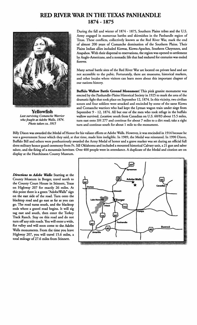
YellowfishLast surviving Comanche Warriorwho fought at Adobe Walls, 1874.
Photo taken ca. 1915
Billy Dixon was awarded the Medal of Honor for his valiant efforts at Adobe Walls. However, it was rescinded in 1914 because hewas a government Scout which they said, at that time, made him ineligible. In 1989, the Medal was reinstated. In 1990 Dixon,Buffalo Bill and others were posthumously awarded the Army Medal of honor and a grave marker was set during an official fulldress military honor guard ceremony from Ft. Sill Oklahoma and included a mounted historical Calvary unit, a 21 gun and sabersalute, and the firing of a mountain howitzer. Over 400 people were in attendance. A duplicate of the Medal and citation are ondisplay at the Hutchinson County Museum.
Directions to Adobe Walls: Starting at theCounty Museum in Borger, travel north tothe County Court House in Stinnett, Texason Highway 207 for exactly 26 miles. Atthis point there is a green "AdobeWalls" signon the east side of the road. Turn onto theblacktop road and go east as far as you cango. The road turns south, and the blacktopends where a gravel road begins. It will zigzag east and south, then enter the TurkeyTrack Ranch. Stay on this road and do notturn off any side roads. You will enter a wide,flat valley and will soon come to the AdobeWalls monuments. From the time you leaveHighway 207, you will travel 15.6 miles, atotal mileage of 27.6 miles from Stinnett.

ADOBE WALLS
WAGON TRAIN
BUFFALO WALLOW FIGHT
I BATTLE OF SWEETWATER (RECK, SEPT. 12
FARNSWORTH'S ENGAGEMENT, NOV.
BATTLE OF MtCLELLAN CHEEK, NOV.
PALO DURO CANYON, SEPT.
BATTLE Of RED RIVER, AUG. 30
Booming BorgerFrom Lawless Beginnings To Progressive Panhandle City
As late as 1925 there were fewer than 100 registered votersin Hutchinson County where some oil well drilling activity wasdeveloping. Then on January 11, 1926 the Smith #1 blew in at10,000 barrels per day and pandemonium broke out. Within days,millions of dollars were spent on leases; within weeks, men by thethousands poured into the area, and by the end of the year, over800 wells had been drilled. It was in the frenzied atmosphere thatwell known town builder, A.P. "Ace" Borger, acquired 240 acres andestablished his namesake.
Borger, Texas burst into being on the raw windy day ofMarch 8, 1926. That morning it was nothing more than a few stakesdriven into the ground and an idea in the, mind of burly, cigarchewing A.P. "Ace" Borger. By sunset, Borger was a reality and Acewas $100,000 richer. The town grew dramatically, both in size andin reputation. By the end of the year it contained 10,000 or 20,000or 30,000 people. Nobody knows for sure because the rowdy, lawless,crowded boom town changed complexion from day to day.
The new town, flooded with workers earning big money, quicklyattracted a large criminal element. That group gained control of thetown before it had a chance to grow. They even made convictedOklahoma murderer, "Two Gun Dick" Herwig, the city's chief lawenforcement officer. During that period of national prohibition, beerjoints and whiskey sales flourished in Borger. Dance halls, gamblingestablishments, and houses of prostitution abounded in the wide opentown. Popular tradition has it that there was a murder per day duringits heyday. Although a murder per day is a considerable overstatementof the situation, the town saw more than its share of violent death.
Local law enforcement either would not or could not bring orderto the chaos that reigned supreme during the boom. Conditionsdeteriorated to the point that state officials were forced to take ahand. At about the time of Borger s first birthday celebration, thegovernor sent the Texas Rangers to clean up the town. They stayed fora short time and about the middle of June declared Borger to be freeof crime and corruption. Those who witnessed the event claimed thatthere was a line of "ladies of the evening" over a mile long trudgingdown the road from Borger to Amarillo after the Rangers gave themuntil sundown to get out of town.
The Ranger interlude proved to be only a lull in the activity,for as soon as they left the criminal activity returned to Borger. Thelawless element was a little more circumspect in its activity this time
and managed to operate a few more years.Then on September 13, 1929, an unknown assailant shot and
killed district attorney Johnny Holmes in Borger. Texas GovernorDan Moody declared martial law in Borger and sent both the Rangersand the National Guard to maintain order. From September 29 toOctober 29 of 1929, the town remained under state control. Thistime when the outside law enforcement authorities left, the hold ofthe criminal element was broken once and for all.
Thus, a stable community, centered around oil and gasproduction and distribution, grew out of the boom-era chaos. Carbonblack plants, refineries, natural gas plants, and a complex pipelinesystem processed and transported Borgers numerous petroleumproducts to the waiting world. By the end of the 1930s, the Borgerarea including Phillips, Sanford and Fritch, was a major Americanpetroleum supplier and an important part of the overall national oilindustry.
Reprinted from A Salute To The Don D. Harrington Petroleum commemorativebooklet published by Panhandle-Plans Historical Museum, Canyon, Texas
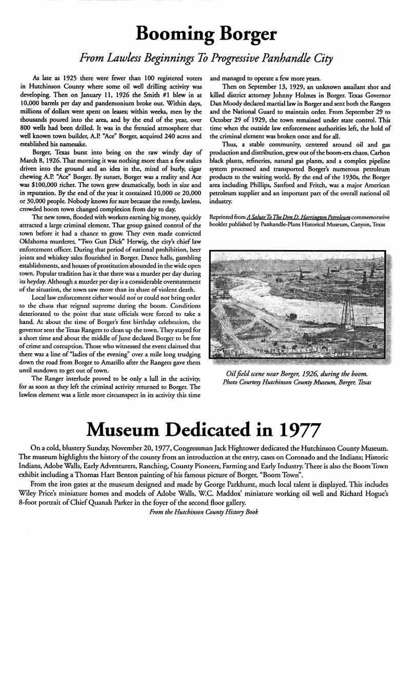
Oil field scene near Borger, 1926, during the boom.Photo Courtesy Hutchinson County Museum, Borger, Texas
Museum Dedicated in 1977On a cold, blustery Sunday, November 20, 1977, Congressman Jack Hightower dedicated the Hutchinson County Museum.
The museum highlights the history of the county from an introduction at the entry, cases on Coronado and the Indians; HistoricIndians, Adobe Walls, Early Adventurers, Ranching, County Pioneers, Farming and Early Industry. There is also the Boom Townexhibit including a Thomas Hart Benton painting of his famous picture of Borger, "Boom Town".
From the iron gates at the museum designed and made by George Parkhurst, much local talent is displayed. This includesWiley Price s miniature homes and models of Adobe Walls, W.C. Maddox' miniature working oil well and Richard Hogue s8-foot portrait of Chief Quanah Parker in the foyer of the second floor gallery.
From the Hutchinson County History Book