Re-inventing the Map - Landcare Research · Re-inventing the Map Experiencing New Zealand: past ......
10
1975 1980 2010 2015 2000 2005 1990 1995 1985 2020 ? Re-inventing the Map Experiencing New Zealand: past – present – future Robert Gibb Landcare Research 12 October 2016 LINK Seminar @ MPI
Transcript of Re-inventing the Map - Landcare Research · Re-inventing the Map Experiencing New Zealand: past ......

1975 1980 2010 2015 2000 2005 1990 1995 1985 2020
?
Re-inventing the Map
Experiencing New Zealand: past – present – future
Robert Gibb
Landcare Research 12 October 2016 LINK Seminar @ MPI

1975 1980 2010 2015 2000 2005 1990 1995 1985 2020
?
1975-2015
gumboots to cellphones
in 40 years

1975 1980 2010 2015 2000 2005 1990 1995 1985 2020
?
1
10
100
1,000
10,000
100,000
1,000,000
10,000,000
100,000,000
1,000,000,000
10,000,000,000
100,000,000,000
1,000,000,000,000
10,000,000,000,000
1975 1980 1985 1990 1995 2000 2005 2010 2015 2020
Speed MHz Cores Removable Storage Capacity Bytes
10 TB
1 TB
100 GB
10 GB
1 GB
100 MB
10 MB
1 MB
100 KB
10 GHz
1 GHz
100 MHz
10 MHz
1 MHz
.
Intel x86 | 64-bit multi-core
CPU: 8-bit | 16-bit | 32-bit
Removable
Storage:
: … … … … … … | USB flash / Memory card - - -
| DVD-RW - - -
| RL 01/02 Cartridge || CD-ROM - - -
Floppy disk - - -
Typical Large Spatial ‘Database’ Size
IBM
DIGITAL EQUIPMENT SUN MICROSYSTEMS
NUMEROUS INTEL x86 VENDORS
SILICON GRAPHICS > SGI > HP
CRAY > SGI > CRAY
10,000x core
1,000x core
100x core
10x core
1x core
Computers enable
data & modelling

1975 1980 2010 2015 2000 2005 1990 1995 1985 2020
?
ISPs ADSL/VDSL KAREN fibre
Post Office leased lines & dial-up – Telecom
+ dial-up ...
1
10
100
1000
10000
100000
1000000
10000000
100000000
1E+09
1E+10
1E+11
1E+12
1E+13
1975 1980 1985 1990 1995 2000 2005 2010 2015 2020
NZ Science Network
NZ Science nodes International speed NZ Science Backbone speed Access speed Removable Storage Capacity Bytes
1 Tb/s
100 Gb/s
10 Gb/s
1 Gb/s
100 Mb/s
10 Mb/s
1 Mb/s
100 Kb/s
10 Kb/s
1 Kb/s
100 b/s
10
1
10 TB
1 TB
100 GB
10 GB
1 GB
100 MB
10 MB
1 MB
100 KB
DSIRnet
Waikato
VUW-Massey
MAFnet
International
MWD
300 b/s
2,400 b/s
4,800 b/s
48 Kb/s
2 Mb/s
512 Mb/s 1 Gb/s
10 Gb/s
100 Gb/s
REANNZ TUIAnet > ISPs
Networks enable communication, sharing & collaboration

1975 1980 2010 2015 2000 2005 1990 1995 1985 2020
?
ISO – International Standards Organisation
TCP/IP network transport standard
UNIX-PC-MAC file mount & print Interchangeable floppy disk file system
CD/DVD file system standard HTTP web service protocol
OGC Geospatial data theory Web Map API
GML - Geographic data files Web features & Web Processing API
Observation & Measurement theory GeoSciML
CityGML Earth Observation
ANZSoilML IndoorML
TimeSeriesML WaterML
DGGS theory
Mail exchange, File transfer, Telnet service protocols
HTML web page file
Program API
Domain design
Data theory
File Formats
Road Rules
Hardware
User’s s/w
Industry competition / Collaboration / IEC - International Electrotechnical Commission Community RFCs IETF - Internet Society
W3C – World Wide Web Consortium OGC – Open Geospatial Consortium
Standards enabling
collaboration & interoperability

1975 1980 2010 2015 2000 2005 1990 1995 1985 2020
?
DSIR: EPIC
ERDAS
GRASS
R Spatial
RIOS python raster Google Earth Engine
Python spatial
MWD: LADEDA ARC/INFO pcArc/Info ArcGIS
OSGeo: QGIS OSGeo: QGIS + GRASS
GenaMap MapInfo
OSGeo: MapServer OSGeo: GeoServer
PYXIS Innovation: WorldView DGGS Google Maps Google Earth
OSGeo: OpenLayers
Image Processing
Vector GIS
Web GIS
Modelling – desktop to cloud to supercomputer
Standards enabling
modular software &
shared software effort
1975 1980 2010 2015 2000 2005 1990 1995 1985 2020
?
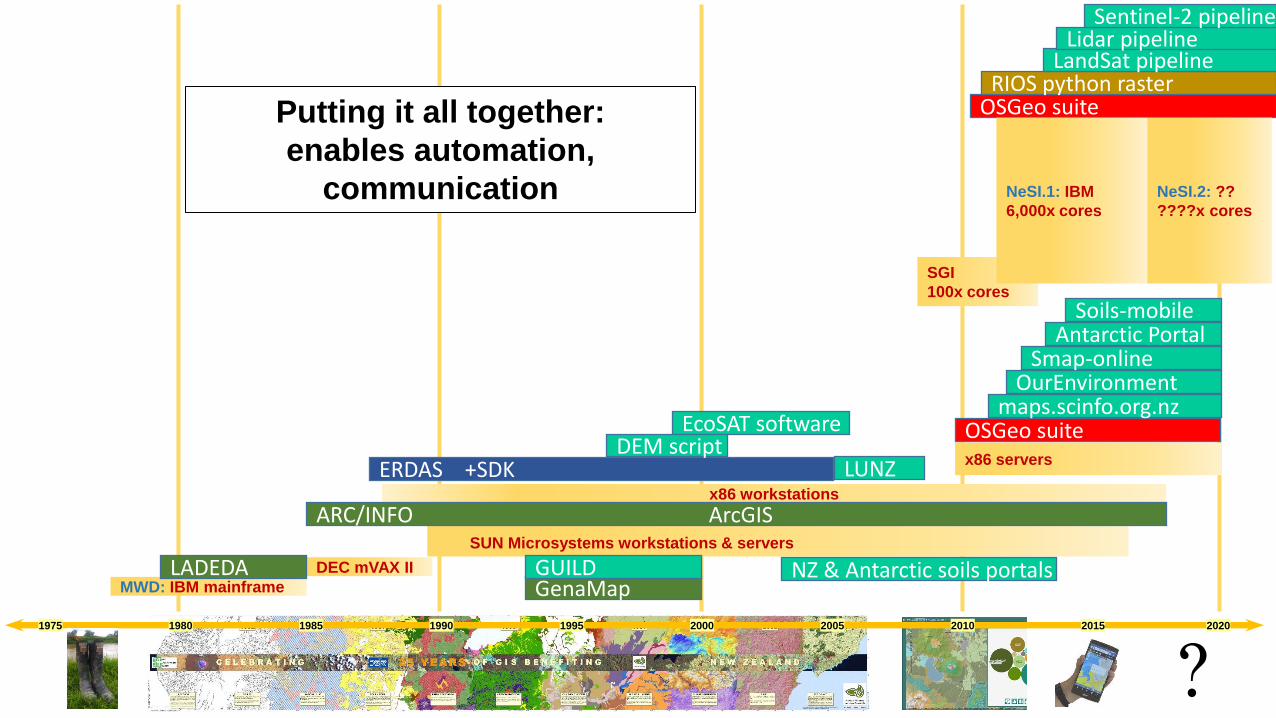
MWD: IBM mainframe
DEC mVAX II
SUN Microsystems workstations & servers
x86 workstations
SGI
100x cores
LADEDA
ARC/INFO ArcGIS
GenaMap
x86 servers
GUILD
OSGeo suite
OurEnvironment Smap-online
Soils-mobile
NZ & Antarctic soils portals
Antarctic Portal
maps.scinfo.org.nz
OSGeo suite RIOS python raster
LandSat pipeline Lidar pipeline
Sentinel-2 pipeline
ERDAS +SDK
EcoSAT software DEM script
NeSI.1: IBM
6,000x cores
NeSI.2: ??
????x cores
LUNZ
Putting it all together:
enables automation,
communication

1975 1980 2010 2015 2000 2005 1990 1995 1985 2020
?
MWD: IBM mainframe
DEC mVAX II SUN Microsystems workstations & servers
x86 workstations
NeSI.1: IBM
6000x cores
LADEDA ARC/INFO
Antarctic Env Dom
NeSI.2: ??
??x cores
OSGeo suite RIOS python raster
LCDB3 base
1m GWRC DEM
ERDAS +SDK
EcoSAT 25m & 15m DEMs
LCDB2 base Land Use NZ LCDB4 base
SPDlib Lidar engine
Antarctic ED 2+
1m Northland LENZ engine 2 & 3
LENZ engine 1 LENZ
LUM 1990 (2000) 2008 2012
Satellite image cube + Big Data + IoT . < < - - - - - - - - - - - - LandSat + Sentinel > >
Putting it all together:
knowledge from data & modelling
DGGS theory

1975 1980 2010 2015 2000 2005 1990 1995 1985 2020
?
National Labour National Labour National ?
? ? MWD Soil Conservation Centre
Bulk Funded DSIR Land & Soil 75% bulk funded
CRI Landcare Research (LR) 100% competitive funding
CRI (LR) 40-50% Core Fund
CRI (LR) + Challenges
NZLRI field mapping commences
to support transparent allocation of
Ministry of Work’s erosion control subsidies
Rogernomics: privatisation & user pays
- MoW SCC becomes DSIR Land Resources
- data becomes a source of quick revenue
LINZ dramatically lowers data charges
reduces cost of topographic data Putting it all together:
Science & Policy NZGOAL + CC
encourages open data
CRIs formed under companies act
expected to compete for all funding
CRIs core funding
some collaboration
Challenges
all collaboration

1975 1980 2010 2015 2000 2005 1990 1995 1985 2020
?
1981-2016
Acknowledgements:
For much of this period I was
either the provider of the infrastructure
or the Informatics Team leader.
So nothing could have been accomplished
without the inspiration, imagination
and hard work of the whole team.
Many thanks to all of you !