RBDMS 2016 Fall Policy Meeting - Groundwater Protection ... Noveber... · RBDMS 2016 Fall Policy...
25
RBDMS 2016 Fall Policy Meeting
Transcript of RBDMS 2016 Fall Policy Meeting - Groundwater Protection ... Noveber... · RBDMS 2016 Fall Policy...

RBDMS 2016 Fall Policy Meeting

• Develop policy, program guidance and standards for:• Web enabling RBDMS
• New RBDMS initiatives for classic, .net, and Web
• Migration path from classic and .net to Web
• Set development and implementation goals for 2017
• April 2017 RBDMS
2
Meeting Goals

RBDMS Overview
3

What is RBDMS?RBDMS (Risk Based Data Management System) is a suite of integrated data management tools that assist state regulatory agencies in the management and oversight of UIC and oil and gas activities. Built from the bottom-up by the system’s users, RBDMS integrates years of experience in multiple states with data management and program best practices to address the ever evolving needs of state regulatory programs.
RBDMS LeadershipRBDMS Steering Committee – Develops policy, budget and priorities. Right now has representatives from Nebraska, North Dakota, Utah, New York and Michigan. Members are mostly directors and deputy directors of state oil and gas programs.
RBDMS Technical Committee – Welcomes representatives from all RBDMS states. Currently consists of representatives from Nebraska, Arkansas, Oklahoma, Alabama, New York, Colorado and Utah. Members are typically programmatic and IT managers from state oil and gas programs.
4
RBDMS
Partner States as of July 2016

1992 1997 1998 2001 2002 2003 2008 2009 2011 2013 2015 2016
5
RBDMS Project Timeline
RBDMS for injection
wells is launched with
support from DOE’s
Office of Oil & Natural
Gas
RBDMS is expanded
to include GIS,
production reporting
and tracking, and a
field inspecting
category.
RBDMS Classic is
installed in Alaska,
Mississippi, North
Dakota, and Nebraska.
RBDMS states
expand public portal
capabilities to assist
state and industry
data users.
RBDMS
Environmental used
to help states manage
data associated with
their source water
protection programs.
The RBDMS eReport
schema for
production and
injection reporting is
completed and
API/PIDEX accepts it
as a national
standard.
RBDMS.Net, coupled
with enhanced
RBDMS Public Portal
and eReport
capabilities.
eForm goes live,
allowing the state’s oil
and gas well permit
review process to
become paperless
and allow for public
access and comment.
FracFocus.org
launched,
supplementing
initiatives by RBDMS
states to ensure
effective regulatory
oversight and
increase public
access to data about
hydraulic fracturing
operations.
Design of the National
Oil and Gas Gateway
begins.
WellFinder mobile
app is launched in
Oklahoma.
Seismic application is
launched in the state
of Oklahoma. RBDMS
now utilized by 24
states and the Osage
Nation.RBDMS Awarded
the DOE 100 Award:
best 100 scientific
and technological
accomplishments the
department had
funded in its first 23
years.
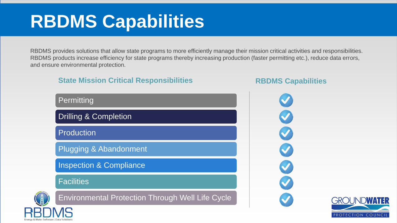
RBDMS provides solutions that allow state programs to more efficiently manage their mission critical activities and responsibilities.
RBDMS products increase efficiency for state programs thereby increasing production (faster permitting etc.), reduce data errors,
and ensure environmental protection.
RBDMS Capabilities
6
Permitting
Drilling & Completion
Production
Plugging & Abandonment
Inspection & Compliance
Facilities
Environmental Protection Through Well Life Cycle
State Mission Critical Responsibilities RBDMS Capabilities

• RBDMS Core (Classic and .net)
• Electronic permitting and reporting
• Field inspection
• Compliance
• RBDMS Environmental
• WellFinder (mobile App)
• RBDMS data portal
• Seismic application
7
RBDMS Product Overview
• Under development• RBDMS Web
• WaterTracker
• AOR 3-D visualization tools
• Updated and enhanced GIS/date interface
• WellFinder (mobile App)
• RBDMS Environmental
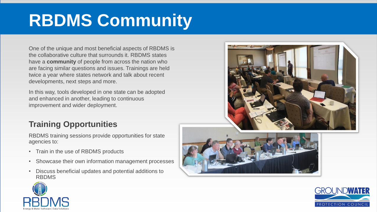
One of the unique and most beneficial aspects of RBDMS is
the collaborative culture that surrounds it. RBDMS states
have a community of people from across the nation who
are facing similar questions and issues. Trainings are held
twice a year where states network and talk about recent
developments, next steps and more.
In this way, tools developed in one state can be adopted
and enhanced in another, leading to continuous
improvement and wider deployment.
Training Opportunities
RBDMS training sessions provide opportunities for state agencies to:
• Train in the use of RBDMS products
• Showcase their own information management processes
• Discuss beneficial updates and potential additions to RBDMS
RBDMS Community
8

9

Electronic Permitting and Reporting – Moving Forward
12/2/2016
10

RBDMS Electronic Permitting/Reporting Status
Existing Under Development Waiting
New York: eform, cold fusion
Michigan: eform
Utah: eform, cold fusion
Alabama: eform
Colorado: eform
North Dakota: PDF forms
Oklahoma: efiler
Nebraska: eform
Arkansas: eform
Oklahoma: eform
Wyoming: eform
Utah: eform
California: RBDMS web forms
New York: Classic
West Virginia: .net
North Dakota: Classic
Mississippi: .net
Other possible
Kansas:
Ohio
Texas
12/2/2016
11

PurposeRBDMS Environmental manages field and other analytical data from areas of oil and gas and mining activities. It is used to track field
observations for soil, sediment, surface water, groundwater, tissue, and air matrices and also accepts analytical water quality and chemical
data reports from industry and third-party laboratories.
12
RBDMS Environmental
Current Updates
• Currently adding more statistical
functions for a variety of state
agencies
• Installing at the Wyoming DEQ,
Wyoming Oil & Gas, and the
Alabama Geological Survey
• Allows for data exports for use by
state program staff in 3rd party GIS
and statistical applications
• Updating the user interface
Water Sample Analysis Map View of Water Monitoring Wells

PurposeeForms integrates seamlessly with RBDMS Core, allowing agencies to collect information from both the regulated community and
the public. eForms increase agency efficiency by allowing oil and gas operators to file for permits and other regulatory forms
electronically and check on their status throughout the review process.
13
RBDMS eForms: Electronic Permitting and Reporting
Product Features
• Color-coding shows the timing status of all tasks
and approaching deadlines for state program staff.
• Program staff receive automated e-mail alerts when
deadlines approach.
• Program staff record comments and conditions of
approval on the same forms that industry submits.
• Roles-based security, SSL ensures that forms in
draft status are kept private from the agency and
the public, yet allows data sharing with other
agencies once forms are submitted.
Colorado eForms

PurposeThe RBDMS Data Portal provides powerful tools for both internal and external users to view and understand RBDMS data and improves
internal and external communication. This is accomplished through internal and public-facing applications that include intuitive search
capabilities, an interactive mapping interface and robust data export options. This tool has been shown to decrease the amount of time
agency staff spend looking for data and responding to public data requests.
14
RBDMS Data Portal
Example of Colorado Data Portal

Purpose
RBDMS Field Inspection is a web-enabled product designed to assist field
inspectors in managing their inspections by minimizing data entry and
maximizing their ability to document site details and problems.
Features
• Offline capabilities
• Secure login
• Available for use in the field on laptops and tablets
• Communicates directly with RBDMS giving supervisors instant results
• Includes a risk matrix to help inspectors prioritize high risk wells
• Access to multilateral and FracFocus data
Usage
Pilot tested in Utah, Michigan and California
15
RBDMS Field Inspection
Field Inspection Screen Images: Secure Log in & Facility/Pit Inspection Form

PurposeWell Finder is a mobile application (iOS & Android) that displays nearby oil, gas,
and injection wells. This tool is used by members of the public, inspectors,
emergency responders and others who must locate wells in their area and
understand basic information about the well. WellFinder is also powered by the
same data as the Oil and Gas Data Gateway which is a central location for
public oil and gas data displayed in both map and tabular formats.
FeaturesSearch wells to display valuable data:
• API (permit) numbers
• Well type (oil, gas, injection, etc.)
• Well status (active or plugged)
• Operator contact information
• Recent & historical production data
• Regulatory agency contacts
UsageTo date, WellFinder contains data for Oklahoma, Nebraska,
New York, Arkansas, and Mississippi.
16
WellFinder Mobile Application
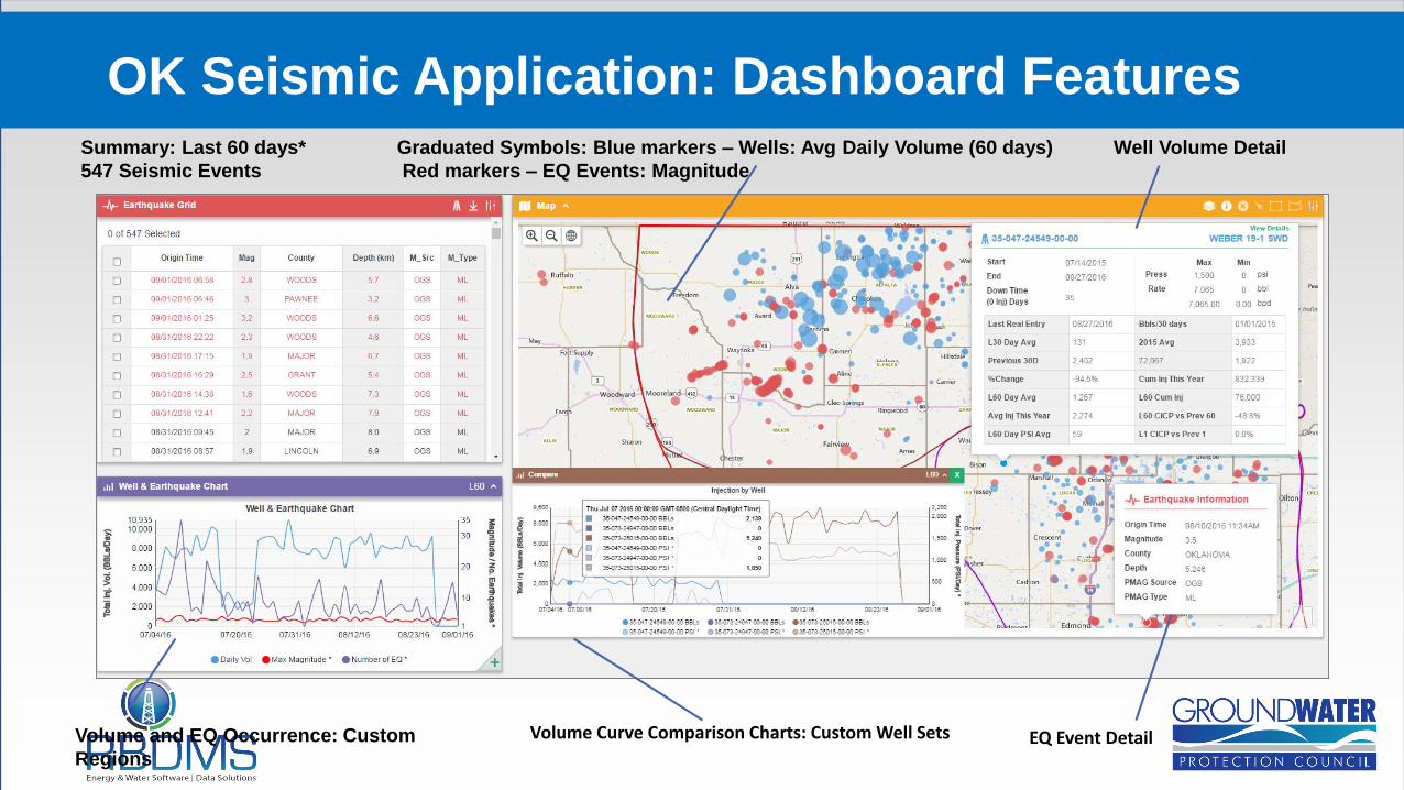
OK Seismic Application: Dashboard Features
Volume and EQ Occurrence: Custom
Regions
Summary: Last 60 days* Graduated Symbols: Blue markers – Wells: Avg Daily Volume (60 days) Well Volume Detail
547 Seismic Events Red markers – EQ Events: Magnitude
Volume Curve Comparison Charts: Custom Well Sets EQ Event Detail
The Future of RBDMS
18
19
RBDMS Next Generation
California WellStar ProjectBeginning in 2015, GWPC began the transition into the next generation of RBDMS in partnership with the California Department of
Conservation’s Division of Oil, Gas, and Geothermal Resources (DOGGR). California selected RBDMS to power their updated oil,
gas and UIC data management system (WellStar). California will be using RBDMS best management practices to upgrade oil and
gas regulatory oversite.
The next generation of RBDMS supplies users with real-time data and collaboration through a modern, web-enabled user interface.
Bringing RBDMS to the web means that both managers and workers will have better tools when and where they need them.
Additional upgrades to the public-facing RBDMS website will improve external communication and agency efficiency.
Area of Review The GWPC is constantly developing new and enhanced tools. Current projects include a mobile field inspection application and an
Area of Review (AOR) 3-D data visualization tool to enhance the ability of agency staff to evaluate aquifer exemptions and potential
risks.
Water TrackerWaterTracker will be installed in California as part of RBDMS 3.0. California Senate Bill 1281 mandates that DOGGR track the
origin and disposition of all water used, produced and disposed in oil and gas operations.

20
Area of Review Module

21
Water Tracking Challenges
RBDMS will be
developing a Water
Tracker product for
source and disposition
data related to
produced water
management.

GWPC Project Reach
22

FY 2016 Objectives
23

24
RBDMS FY 2016 Objectives
Key Project Objectives• Explore additional web based upgrades for RBDMS including .Net, Web, and Environmental
• Upgrade the RBDMS portal user interface in several states to ease public access to data
• Provide training to states
• Improve public access to FracFocus through upgraded search features and a redesigned website
• Update and install RBDMS modules in additional state programs
• Help states address challenges related to produced water reuse
• Support state efforts related to natural gas storage
• Improve the capabilities of eForms to further support electronic commerce and ease paperwork burdens on both states and
industry
• Aid states with continued regulatory improvement through SOGRE

25
RBDMS FY 2016
Project Deliverables• Deploy new eForms with quicker validation for industry
• Explore eForm Builder for simpler form creation for program (non IT) staff
• Perform additional needs assessments: eg. Kansas
• Develop updated Field Inspection module based on research funded in previous fy’s
• Web-enable portions of RBDMS.net
• Additional AOR pilot projects similar to OWSM/OK Seismic App
• Continue state training and sharing innovations across state programs
• Maintain FracFocus Helpdesk support for industry and other users
• Rollout upgraded FracFocus website
• Promote FracFocus usage beyond the U.S.
• Upgrade the WellFinder Mobile App (2.0) and add additional states
• Upgrades states on RBDMS Classic to RBDMS.net
• SOGRE consultations with states
• Produced water primer and forums


![s[l ifsf] nu fgL kf/bzL{ ag fcf}+, k/Dk/fut xf]Og Joj ...krishionline.com/wp-content/uploads/2017/11/krishi-18-2074-8-11.pdf27 Noveber 2017 Monday % %](https://static.fdocuments.net/doc/165x107/60997f41f0b1750c7613a992/sl-ifsf-nu-fgl-kfbzl-ag-fcf-kdkfut-xfog-joj-27-noveber-2017-monday.jpg)