R.B16690.002.04.doc February 2009 - Eurobodalla Shire
61
Wharf Road Coastal Hazard Assessment and Hazard Management Plan A part of BMT in Energy and Environment R.B16690.002.04.doc February 2009
Transcript of R.B16690.002.04.doc February 2009 - Eurobodalla Shire
Wharf Road Coastal Hazard Assessment and Hazard Management Plan
A part of BMT in Energy and Environment
R.B16690.002.04.doc February 2009

G:\ADMIN\B16690.G.MJA_WHARFROADCMP\R.B16690.002.04.DOC
Wharf Road Coastal Hazard Assessment and Hazard
Management Plan
Prepared For: Eurobodalla Shire Council
Prepared By: BMT WBM Pty Ltd (Member of the BMT group of companies)
Offices
Brisbane Denver
Karratha Melbourne
Morwell Newcastle
Perth Sydney
Vancouver

G:\ADMIN\B16690.G.MJA_WHARFROADCMP\R.B16690.002.04.DOC
DOCUMENT CONTROL SHEET
Document :
Project Manager :
R.B16690.002.04.doc
Dr Ian Teakle
BMT WBM Pty Ltd BMT WBM Pty Ltd Level 11, 490 Upper Edward Street Brisbane 4000 Queensland Australia PO Box 203 Spring Hill 4004 Tel: +61 7 3831 6744 Fax: + 61 7 3832 3627 ABN 54 010 830 421 www.wbmpl.com.au
Client :
Client Contact:
Client Reference
Eurobodalla Shire Council
Royce Toohey
Title : Wharf Road Coastal Hazard Assessment and Hazard Management Plan
Authors : Dr Ian Teakle; Malcolm Andrews
Synopsis : A recent DA at Wharf Road, Batemans Bay has been opposed by DECC under the NSW Coastal Policy. This document details the investigations leading to a recommendation on the future management of the area.
REVISION/CHECKING HISTORY
REVISION NUMBER
DATE OF ISSUE CHECKED BY ISSUED BY
0 22 February 2008 MJA IAT
1 23 July 2008 MJA IAT
2 7 November 2008 MJA IAT
3 11February 2009 IAT MJA
4 28 February 2009 IAT MJA
DISTRIBUTION
DESTINATION REVISION
1 2 3 4
Eurobodalla Shire Council
BMT WBM File
BMT WBM Library
4 + CD

CONTENTS I
G:\ADMIN\B16690.G.MJA_WHARFROADCMP\R.B16690.002.04.DOC
CONTENTS
1 INTRODUCTION 1-1
1.1 Historical Context 1-1
2 MANAGEMENT PLAN FRAMEWORK 2-1
2.1 The Coastline Management Manual (1990) 2-1 2.2 The NSW Coastal Policy (1997) 2-1 2.3 Coastal Protection Act 1979 2-2
3 COASTAL PROCESS AND HAZARD ASSESSMENT 3-1
3.1 Review of Previous Reports 3-1 3.1.1 Oceanic Inundation Study, PWD (1989) 3-1 3.1.2 Batemans Bay Vulnerability Study, DLWC (1996). 3-2 3.1.3 Estuary Processes Study, WBM (1999) 3-3 3.1.4 Wharf Road Foreshore Alignment Study, WBM (2000) 3-5 3.1.5 Coastline Hazard Management Plan, WMA (2001) 3-5
3.1.5.1 Hazard Assessment 3-6 3.1.5.2 Management Option Recommendations 3-8
3.2 Inundation Hazard 3-10 3.2.1 Princess Jetty Tide Gauge Analysis 3-10 3.2.2 Future Sea Level Rise 3-11 3.2.3 Inundation Levels 3-11 3.2.4 Inundation Hazard Summary 3-14
3.3 Erosion Hazard 3-14 3.3.1 Short Term Erosion 3-15 3.3.2 Medium Term Erosion/Accretion Cycles 3-15 3.3.3 Long Term Erosion 3-16
3.3.3.1 Historical Trend 3-16 3.3.3.2 Impact of Future Sea Level Rise 3-16
3.3.4 Localised Erosion Risk Due to Structures 3-17 3.3.5 Erosion Prone Area 3-17
4 COASTAL VALUES AND SIGNIFICANCE 4-1
4.1 Issues and Values Derived from EMP Consultation 4-1 4.1.1 Major Issues 4-1
CONTENTS II
G:\ADMIN\B16690.G.MJA_WHARFROADCMP\R.B16690.002.04.DOC
4.1.2 Intermediate Issues 4-1 4.1.3 Minor Issues 4-2
4.2 Issues derived from Public Comments on Development Proposal (Wharf Road Units DA No. 871/02) 4-2
4.2.1 Visual Amenity 4-2 4.2.2 Impacts on Adjacent Foreshore 4-2 4.2.3 Public Access 4-2 4.2.4 Local Drainage Issues 4-2 4.2.5 Maintenance Cost 4-2
5 COASTAL MANAGEMENT OPTIONS 5-1
5.1 Management Goals and Objectives 5-1 5.2 Land Tenure and Zonings 5-1 5.3 Generic Management Options 5-2
5.3.1 Environmental Planning 5-2 5.3.2 Land Acquisition 5-2 5.3.3 Development Control Conditions 5-2 5.3.4 “Soft” Protective Works 5-3 5.3.5 “Hard” Protective Works 5-3
5.3.5.1 Seawalls 5-4 5.3.5.2 Groynes and Artificial Headlands 5-5 5.3.5.3 Offshore Breakwaters and Submerged Reefs 5-5
5.4 Management Option Matrix 5-6 5.5 Management Options for Wharf Road 5-7
5.5.1 Environmental Planning 5-7 5.5.2 Land Acquisition 5-8 5.5.3 Development Control Conditions 5-8 5.5.4 “Soft” Protective Works 5-9 5.5.5 “Hard” Protective Works 5-10
5.5.5.1 Seawall 5-10 5.5.5.2 Groyne/s 5-11
5.5.6 Hybrid Options 5-12 5.5.6.1 Seawall Plus Nourishment 5-12 5.5.6.2 Groynes Plus Artificial Dune 5-12
5.6 Decision Criteria 5-12 5.7 Options Assessment 5-15
5.7.1 Background 5-15 5.7.2 Option Assessment against Criteria 5-15

LIST OF FIGURES III
G:\ADMIN\B16690.G.MJA_WHARFROADCMP\R.B16690.002.04.DOC
5.8 Option Ranking 5-16
6 COMMUNITY CONSULTATION 6-1
6.1 Petition 6-1 6.2 Sam D’Ambrosio (Director Hawkesnest Pty Ltd) 6-1 6.3 Geoff Fielding, Director, Wharf Road Joint Venture 6-2 6.4 Geoff Payne, Director, Zonked Pty Ltd (atf Wharf Road Unit Trust) 6-2 6.5 Southern Rivers Catchment Management Authority 6-2 6.6 The Coastwatchers Association Inc. 6-3 6.7 Summary 6-3
7 FUTURE MANAGEMENT 7-1
7.1 Discussion 7-1 7.2 Recommendation 7-1
8 REFERENCES 8-1
APPENDIX A: LAND TENURE A-1
LIST OF FIGURES
Figure 1-1 Wharf Road Locality Plan. 1-2 Figure 3-1 Conceptual Model of Sand Transport Pathways (after Patterson
Britton & Partners, 1992) 3-9 Figure 3-2 1977 Vegetation Line. 3-18 Figure 3-3 Historical Erosion Setback Line (derived from 1977 vegetation line)
in Relation to 2005 Shoreline. 3-19 Figure 3-4 Schematic of Wharf Road Equilibrium Shoreline (in the complete
absence of continuing sand supply from the east) 3-20 Figure 3-5 Recent Aerial Photograph Showing Localised Downdrift Impacts of
Groin Structure. 3-21

LIST OF TABLES IV
G:\ADMIN\B16690.G.MJA_WHARFROADCMP\R.B16690.002.04.DOC
LIST OF TABLES
Table 3-1 Summary of Ocean Inundation Levels from PWD (1989). 3-1 Table 3-2 Typical Breakdown of 100 year ARI Design MSWL Components. 3-2 Table 3-3 Design Water Levels (50 year ARI ) and Runup Heights for Wharf
Road, DLWC (1996). 3-3 Table 3-4 Summary of Wharf Road Inundation Levels excluding wave effects,
WMA (2001). 3-6 Table 3-5 Summary of Wharf Road Inundation Levels, including wave effects,
WMA (2001). 3-7 Table 3-6 Storm Tide Level Plus Sea Level Rise Allowance, Excluding Wave
Effects. 3-12 Table 3-7 Wharf Road Inundation Levels. 3-13 Table 3-8 Wharf Road Inundation Levels, Allowing For Mid/High Range SLR. 3-14 Table 5-1 Matrix of Beach System Management Options 5-7 Table 5-2 Wharf Road Management Option Selection Criteria 5-14

INTRODUCTION 1-1
G:\ADMIN\B16690.G.MJA_WHARFROADCMP\R.B16690.002.04.DOC
1 INTRODUCTION
This study has been commissioned by Eurobodalla Shire Council to consider the extent of coastline hazards affecting beachfront properties in the Wharf Road East precinct along the northern foreshore of Batemans Bay (Refer Figure 1-1) and to develop a long-term strategic management plan for the area. The management plan will be prepared in accordance with the procedure outlined in the NSW Government’s Coastline Management Manual (1990), NSW Coastal Policy 1997 and provisions of the Coastal Protection Act 1979.
1.1 Historical Context
The Wharf Road east precinct study area is situated along an approximately 400 m stretch of active shoreline/beach, with nearshore shoals subject to tidal currents, low wave climate driven sand transport and intermittent flood scour. Due to the complex interaction of these shaping processes, the study area shoreline has experienced considerable instability (comprising both erosive and accretive movements) over the last 150 years (WBM, 1999).
A residential subdivision dating back to the late 19th century occurred during a relatively accreted shoreline phase. As evidenced in Figure 1-1, the shoreline has eroded substantially leaving many allotments below the High Water Mark. The area is currently zoned for residential-tourism development, with minimum floor levels and additional development conditions in place as a means of mitigating the coastal hazard risk associated with future development.
Earlier studies, in particular the Batemans Bay Coastline Hazard Management Plan (WMA, 2001), have identified that the Wharf Road east precinct is currently exposed to both coastal inundation and shoreline erosion hazards.
To the west of the study area, a seawall was constructed in the 1960/1970s. No formal hazard mitigation has been constructed along the Wharf Road east precinct, however some rock protection has been placed along the exposed corner of Wharf Road and ad hoc measures (e.g. car tyres) to reduce erosion have been placed by landowners. More recently a landowner has constructed a substantial groyne without obtaining council approval.
The current study is aimed at ensuring that future management of the Wharf Road shoreline is undertaken in an informed and strategically integrated manner.

INTRODUCTION 1-2
G:\ADMIN\B16690.G.MJA_WHARFROADCMP\R.B16690.002.04.DOC
Figure 1-1 Wharf Road Locality Plan.

MANAGEMENT PLAN FRAMEWORK 2-1
G:\ADMIN\B16690.G.MJA_WHARFROADCMP\R.B16690.002.04.DOC
2 MANAGEMENT PLAN FRAMEWORK
The Wharf Road East Precinct Management Plan has been undertaken in accordance with NSW state government/local government policy and legislation. The relevant policy documents are briefly described below in the context of how they apply to coastline management plans.
2.1 The Coastline Management Manual (1990)
The NSW Government’s Coastline Management Manual (1990) was released with the Coastline Hazard Policy 1988, to assist local councils with a better understanding of coastal processes, hazards and coastal management so that balanced, sustainable, merit based decisions could be reached. The Manual sets down a structured, step-wise management system that requires other planning factors, such as social, economic, recreational, aesthetic and ecological issues, be weighed along with coastline hazard considerations and beach amenity requirements, when preparing a Coastline Management Plan.
The primary objective of the Coastline Hazard Policy (1988) is stated to be “to reduce the impact of coastal hazards on individual owners and occupiers, and to reduce private and public losses resulting from natural coastal forces”. It is stated in this policy that:
• the impact of coastal forces on existing developed areas shall be reduced by works and measures and by the purchase of property on a voluntary basis, where appropriate;
• the potential for coastal damage in respect of any proposed coastline development shall be contained by the application of effective planning and development controls by local councils; and
• a merit approach to all development and building decisions which takes account of social, economic and ecological as well as oceanic process considerations, shall be followed by local councils and developers.
2.2 The NSW Coastal Policy (1997)
The NSW Government adopted the Coastal Policy in 1997. The Policy has as its central focus the ecologically sustainable development (ESD) of the NSW coast. This is in recognition that the coast is a unique environment to be conserved and enhanced for its natural and cultural values while also providing for the economic, social and spiritual well-being of the community.
The Coastal Policy has nine goals (refer below), each underpinned by objectives that are to be achieved by strategic actions. The preparation and implementation of Coastal Zone Management Plans, in accordance with the Coastline Management Manual, are among those strategic actions.
NSW Coastal Policy Goals:
1. Natural environment protected, rehabilitated and improved;
2. Coastal processes and hazards recognised and accommodated;
3. Aesthetic qualities protected and enhanced;
MANAGEMENT PLAN FRAMEWORK 2-2
G:\ADMIN\B16690.G.MJA_WHARFROADCMP\R.B16690.002.04.DOC
4. Cultural heritage protected and enhanced;
5. Ecologically sustainable development and use of resources;
6. Ecologically sustainable human settlement;
7. Appropriate public access and use;
8. Information to enable effective management;
9. Integrated planning and management.
2.3 Coastal Protection Act 1979
The NSW Coastal Protection Act (1979) was amended in 2002 to better implement the intent of the NSW Coastal Policy 1997. The amendments enshrine the principles of ecologically sustainable development and included provisions dealing with the preparation of Coastal Zone Management Plans. The amendments, amongst other things, provide the Minister for Environment and Climate Change with the power to direct a Council whose area falls within the coastal zone to prepare a Coastal Zone Management Plan. The amendments specify matters that must be dealt with in the Coastal Zone Management Plan and the process for its preparation, approval, gazettal and future amendment, if necessary.
Specifically, the Act now directs that Coastal Zone Management Plans must:
1. Include provision for emergency management works during periods of beach erosion; and
2. Provide for continuing and undiminished public access to beaches, headlands and waterways.

COASTAL PROCESS AND HAZARD ASSESSMENT 3-1
G:\ADMIN\B16690.G.MJA_WHARFROADCMP\R.B16690.002.04.DOC
3 COASTAL PROCESS AND HAZARD ASSESSMENT
3.1 Review of Previous Reports
There are a number of preceding reports that are relevant to a hazard assessment of Wharf Road, the findings of which are summarised below.
3.1.1 Oceanic Inundation Study, PWD (1989)
The Oceanic Inundation Study was undertaken by the then NSW Public Works Department (PWD) at the request of Eurobodalla Shire Council (ESC) in order to provide advice on the likelihood and degree of oceanic flooding around Batemans Bay.
As part of the Oceanic Inundation Study, data analysis and numerical modelling was undertaken by Lawson and Treloar (L&T, 1987) in order to quantify the ocean inundation hazard. This involved numerical modelling of wind and pressure setup, wave propagation into Batemans Bay and wave setup and also river flooding. Monte-Carlo simulation was undertaken in order to derive the joint probability of these separate contributions to coastal inundation.
The Oceanic Inundation Study reported on “Still Water Levels” with Average Recurrence Intervals (ARIs) of 20, 50 and 100 years at Wharf Road. These “Still Water Levels” comprised astronomic tide level plus wind and pressure setup and also included the mean water level setup at the shoreline due to waves. This value will be referred to in the current study as the “Mean Shoreline Water Level” (MSWL) and is summarised in Table 3-1. A 0.3 m uncertainty allowance was included in the design mean shoreline water levels at Wharf Road, however there was no allowance made for future Sea Level Rise in these values.
Table 3-1 Summary of Ocean Inundation Levels from PWD (1989).
Average Recurrence Interval (years)
20 50 100
Mean shoreline water level (m AHD) 2.13 2.27 2.36
River Flood Increment (m) 0.04 0.06 0.08
Uncertainty Allowance (m) 0.3 0.3 0.3
Design mean shoreline water level (m AHD) 2.5 2.6 2.7
A typical breakdown of individual components contributing to the 100 year ARI MSWL is provided in Table 3-2. The WBM (1999) Estuary Processes Study subsequently identified that the wave setup contribution of 1 m was probably on the conservative side and that the use of the additional uncertainty allowance was being overly conservative.
COASTAL PROCESS AND HAZARD ASSESSMENT 3-2
G:\ADMIN\B16690.G.MJA_WHARFROADCMP\R.B16690.002.04.DOC
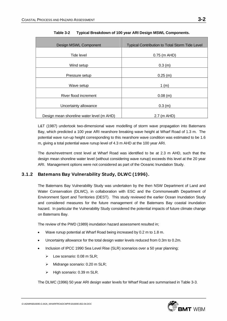
Table 3-2 Typical Breakdown of 100 year ARI Design MSWL Components.
Design MSWL Component Typical Contribution to Total Storm Tide Level
Tide level 0.75 (m AHD)
Wind setup 0.3 (m)
Pressure setup 0.25 (m)
Wave setup 1 (m)
River flood increment 0.08 (m)
Uncertainty allowance 0.3 (m)
Design mean shoreline water level (m AHD) 2.7 (m AHD)
L&T (1987) undertook two-dimensional wave modelling of storm wave propagation into Batemans Bay, which predicted a 100 year ARI nearshore breaking wave height at Wharf Road of 1.3 m. The potential wave run-up height corresponding to this nearshore wave condition was estimated to be 1.6 m, giving a total potential wave runup level of 4.3 m AHD at the 100 year ARI.
The dune/revetment crest level at Wharf Road was identified to be at 2.3 m AHD, such that the design mean shoreline water level (without considering wave runup) exceeds this level at the 20 year ARI. Management options were not considered as part of the Oceanic Inundation Study.
3.1.2 Batemans Bay Vulnerability Study, DLWC (1996).
The Batemans Bay Vulnerability Study was undertaken by the then NSW Department of Land and Water Conservation (DLWC), in collaboration with ESC and the Commonwealth Department of Environment Sport and Territories (DEST). This study reviewed the earlier Ocean Inundation Study and considered measures for the future management of the Batemans Bay coastal inundation hazard. In particular the Vulnerability Study considered the potential impacts of future climate change on Batemans Bay.
The review of the PWD (1989) inundation hazard assessment resulted in;
• Wave runup potential at Wharf Road being increased by 0.2 m to 1.8 m.
• Uncertainty allowance for the total design water levels reduced from 0.3m to 0.2m.
• Inclusion of IPCC 1990 Sea Level Rise (SLR) scenarios over a 50 year planning;
Low scenario: 0.08 m SLR;
Midrange scenario: 0.20 m SLR;
High scenario: 0.39 m SLR.
The DLWC (1996) 50 year ARI design water levels for Wharf Road are summarised in Table 3-3.

COASTAL PROCESS AND HAZARD ASSESSMENT 3-3
G:\ADMIN\B16690.G.MJA_WHARFROADCMP\R.B16690.002.04.DOC
Table 3-3 Design Water Levels (50 year ARI ) and Runup Heights for Wharf Road, DLWC (1996).
MSWL (m AHD)
MSWL + SLR (low)
(m AHD)
MSWL + SLR (mid)
(m AHD)
MSWL + SLR (high)
(m AHD) Wave Runup
(m)
2.6 2.7 2.8 3.0 1.8
The Vulnerability Study assessment concluded that the Wharf Road area is at serious risk of overtopping. Management options identified were to raise the revetment protecting the caravan park and to set minimum floor levels. Management options for the sub-divided area to the east of the caravan park were not considered in this study. Likewise, shoreline erosion was not identified as a hazard for the Wharf Road, probably because of the focus on the western part of the precinct, which is protected by a rock seawall.
3.1.3 Estuary Processes Study, WBM (1999)
An Estuary Processes Study was undertaken by WBM on behalf of ESC in order to develop an understanding of the various estuarine processes and their interactions. Of particular relevance to the coastal hazards at Wharf Road was an assessment that was made of sedimentation processes within the inner region of Batemans Bay.
Of relevance to the entire inner region of Batemans Bay, including Wharf Road, it was identified that 80% of sand supplied from the river to the bay over the last 100 years has accreted on Corrigans Beach due to the influence of the breakwater constructed along the southern river/bay shoreline. This will have reduced the sand supply available to other beach units within the inner bay, including Surfside Beach, Cullendulla Beach and the Wharf Road precinct. The Corrigans Beach compartment has now all but extended the length of the constructed breakwater and its capacity to act as a sink for river sand supply should correspondingly reduce.
The historic shoreline behaviour of the Wharf Road area as recorded in historical navigation charts and aerial photographs was analysed. From this analysis it was concluded that there are two fundamental configuration categories for the shoreline and shoals at Wharf Road, being;
• Nearshore current dominant sand movement with a shoreline shape which runs more or less east-west from Surfside Beach through to the river channel (e.g. 1922, 1931, 1949, 1978, 1995); and
• Wave dominant shoreline evolution forming a well established sand spit aligned more or less parallel to the wave crests in the area (e.g. 1964, 1981/2).
The highly dynamic behaviour of the Wharf Road shoreline was rationalised in terms of an understanding of the complex interactions of waves and currents within the inner Batemans Bay and in the vicinity of the Clyde River entrance. The following excerpt from WBM (1999) describes the relevant processes and their interactions;
The highly dynamic behaviour of the area near Wharf Road is influenced by:

COASTAL PROCESS AND HAZARD ASSESSMENT 3-4
G:\ADMIN\B16690.G.MJA_WHARFROADCMP\R.B16690.002.04.DOC
• the supply of sand to the area (by waves and currents) from Surfside Beach and/or the ramp margin shoals;
• gradual but persistent nearshore currents;
• waves reaching the area from offshore, particularly larger waves during storms;
• occasional floods.
Both waves and nearshore currents have substantial effect in shaping the Wharf Road foreshore area, including both onshore and longshore sand movement. Waves influences are dominant during short term storm events with large ocean waves propagating to the area from offshore. Outflowing currents past the site dominate during major river flood events.
At most times, low to moderate wave action and ebb/flood tidal currents interact to cause slower but significant progressive sand transport and shoreline changes over the longer term (weeks, months or years depending on extreme event occurrences). The sand in the foreshore and nearshore system is moved by the combined action of waves and currents generated by both tides and waves.
Waves are dominant in moving sand both onshore (mass transport) and along the shoreline (longshore transport) predominantly towards the west. Wave-induced longshore transport occurs mainly within the wave breaker zone where greater agitation of the bed sediments and significant wave-induced longshore currents are generated. Waves are thus dominant in shaping the beach shoreline shape.
Waves are very influential during storms with big seas offshore. Wave access to the foreshore is greatest at high tide, particularly in conjunction with storm surge and wave setup. Waves therefore cause greatest sand movement to and past the area during big spring high tides, particularly during storm events.
Tidal currents play a significant role in re-distributing sand within the nearshore areas. This occurs as a gradual process except when some major event (storm or flood) disrupts the slowly developing pattern. Tidal currents are clearly strongest during big spring tides, are directed predominantly alongshore, and tend to be strongest in the channel areas. When occurring jointly with wave action, the predominant current direction would be towards the west in this area.
Floods will significantly strengthen the ebb tide current and can cause gross re-distributions of sand in the offshore direction in a short time. This occurs wherever the flood current breaks through the river mouth shoals to the Bay including in the nearshore area adjacent to Wharf Road. This is identified as an important factor in re-supplying Surfside Beach with sand in the longer term.
The supply of sand from adjacent areas such as Surfside Beach and the ramp-margin shoals is dependent on equivalent processes there. It is probably variable, ranging from persistent low rates to occasional short term high rates of transport in the nearshore tidal and wave-induced current zone and along the foreshore itself.

COASTAL PROCESS AND HAZARD ASSESSMENT 3-5
G:\ADMIN\B16690.G.MJA_WHARFROADCMP\R.B16690.002.04.DOC
Thus, the natural system is highly dynamic and at any time is the accumulated net result of many factors, some of which are slow and progressive while others are unpredictable, infrequent and irregular but of relatively major influence.
There are no theories or models which can reproduce or represent the above combination of processes over the time-frame of natural changes. Some of the major influences are either of such long term or of such infrequent and irregular occurrence that any given general pattern of shoals and foreshore shape probably never recurs or (in broader terms) may recur in cycles of decades or centuries. For example, the shoreline shape with a prominent spit feature evident in 1864 is not recorded again in the charts or photos until 1981, at which time it is essentially identical in general form.
A conceptual model of sand transport pathways within the inner Batemans Bay was reworked by WBM (1999) from Patterson Britton & Partners (1992) and is reproduced here in Figure 3-1.
As part of the Estuary Processes Study two-dimensional wave modelling was undertaken coupled with a two-dimensional hydrodynamic model which indicated that while wave set-up occurs quite broadly across Batemans Bay, the allowances derived in the Vulnerability and Ocean Inundation studies were most likely quite conservative and could be used without additional provisions for uncertainty.
3.1.4 Wharf Road Foreshore Alignment Study, WBM (2000)
WBM undertook a study for ESC in order to assess foreshore alignment/protection options in the Wharf Road area.
As part of this study an assessment was made of 4 historical navigation charts (from 1898, 1822, 1931 and 1978) and 8 aerial photographs (1949, 1964, 1977, 1981, 1982, 1986, 1987 and 1999) in order to identify percentage exceedance lines for the historical shoreline alignment.
This analysis was performed in the context of identifying appropriate alignments for foreshore protection works (revetments), and in particular to assist in identifying the percentage time that a given revetment option would have a usable (dry) beach in front of it at high tide. As such, the 100% line derived from this analysis should not be considered as an appropriate setback line for development in the absence of foreshore protection works. That is, there are no assurances that future erosion/accretion cycles will not proceed beyond the extent observed in the 12 discrete shoreline snapshots used in this analysis.
Furthermore, this analysis makes no provision for postulated rise in mean sea level due to climate change, a fundamental component for consideration of foreshore building setbacks in the coastal zone.
3.1.5 Coastline Hazard Management Plan, WMA (2001)
Webb Mckeown and Associates (WMA) prepared a coastline hazard management plan for the ESC, which set out to review the work undertaken for the Vulnerability Study and determine preferred coastal hazard management options. Some of the conclusions with respect to the Wharf Road precinct are given below.

COASTAL PROCESS AND HAZARD ASSESSMENT 3-6
G:\ADMIN\B16690.G.MJA_WHARFROADCMP\R.B16690.002.04.DOC
3.1.5.1 Hazard Assessment
The major hazard identified for the Wharf Road precinct was ocean inundation as a result of high astronomic tides combined with storm surge (wind stress and barometric effects during major storms), some minor Clyde River flooding effects, plus wave setup, runup and overtopping of the foreshore. Medium to long term cycles of foreshore erosion/accretion were also identified as posing a hazard to development or potential development in the eastern section of the Wharf Road coastal precinct, which is not protected by a rock revetment.
Storm tide levels (astronomic tide plus storm surge), which had been previously derived from Fort Denison (Sydney) tide records, were adopted with minor adjustments for Batemans Bay. These levels (not including wave setup) were;
• 1% AEP: 1.50 m AHD
• 2% AEP: 1.45 m AHD
• 5% AEP: 1.40 m AHD
An estimated “most likely” sea level rise of 0.20 m over a 50 year planning period was adopted from the recommendations of the IPCC (1996). Based on the earlier PWD (1989) inundation study a 5% AEP River flood allowance was included with the 1% AEP storm surge level. This corresponded to a 0.1 m allowance in the vicinity of Wharf Road. The WMA (2001) inundation levels at Wharf Road, excluding wave effects, are summarised in Table 3-4. It was noted that the water levels in Table 3-4 were similar to, or marginally higher than, the level of the existing Wharf Road foreshore wall, roadways and general ground level along the foreshore.
Table 3-4 Summary of Wharf Road Inundation Levels excluding wave effects, WMA (2001).
Inundation Component 5 % AEP 2 % AEP 1 % AEP
Astronomic Tide & Storm Surge (m AHD) 1.4 1.45 1.5
River Flooding (m) 0.1 0.1 0.1
50 year Climate Change (m) 0.2 0.2 0.2
Design Water Level excluding wave effects (m AHD) 1.7 1.75 1.8
Nearshore wave heights of 1.3 m were anticipated for an offshore significant wave height of 10 m. The following theoretical wave setup allowances were adopted for the CBD and Wharf Road precincts;
• 1% AEP: 0.25 m;
• 2% AEP 0.2 m;
• 5% AEP 0.15 m.
These values are significantly less than those adopted in the Oceanic Inundation Study (PWD, 1989) and in the later Batemans Bay Vulnerability Study (DLWC, 1996), which were around 1 m for the 1% AEP – refer Section 3.1.1. As discussed in Section 3.1.3, WBM (1999) identified that the DLWC

COASTAL PROCESS AND HAZARD ASSESSMENT 3-7
G:\ADMIN\B16690.G.MJA_WHARFROADCMP\R.B16690.002.04.DOC
1996) values were probably on the conservative side, however the numerical modelling undertaken suggested that significant wave setup (~0.4m) could be generated across the central and inner bay in general, due to waves breaking in the outer bay. In addition to this bay-wide setup, localised shoreline setup is generated due to waves breaking in the nearshore.
Wave runup potential, dune/revetment overtopping rates and wave overtopping inundation levels were evaluated separately for Wharf Road West, which is protected by a revetment, and Wharf Road East, which is not formally protected. These are summarised in Table 3-5.
Table 3-5 Summary of Wharf Road Inundation Levels, including wave effects, WMA (2001).
Estimated Wave Overtopping Inundation Levels (m AHD)
Location Average Dune/Wall
Height (m AHD)
AEP Potential Setup Level
(m AHD)
Potential Runup
(m) Backshore Foreshore
5% 1.85 1.4 1.8 2.2
2% 1.95 1.4 1.9 2.3
Wharf Rd West
1.5 to 2.0
1% 2.05 1.4 2.0 2.4
5% 1.85 1.4 1.8 2.3
2% 1.95 1.4 1.9 2.4
Wharf Rd East
1.5
1% 2.05 1.4 2.0 2.5
Based on the levels determined by WMA, coastal inundation poses a serious risk to existing development along the Wharf Road coastal strip. With inundation levels excluding wave effects above the height of the frontal dune and top of revetment elevations, there would be direct wave attack on the caravans and residences in the foreshore strip. Here, wave inundation levels would be over 1.0 m above average ground levels and above the floor levels of many buildings. In the back beach areas the 1% AEP inundation level would be around 0.5 m above typical ground levels.
In addition to the inundation assessment WMA (2001) undertook a revised assessment of the percentage exceedance shoreline alignments derived by WBM (2000). The re-assessment placed less weighting on the 4 aerial photos from the 1980s, which happened to be a relatively accreted period and also placed less weighting on the 4 navigation charts. The re-assessed percentage shoreline alignments derived by WMA (2001) were in general more conservative than the WBM (2000) alignments, although the 100% exceedance alignment was similar.
While the Coastline Hazard Management Plan included assessments of the potential for short-term storm erosion as well as likely future recession due to sea level rise for some Batemans Bay beaches, an assessment of these coastal hazards for Wharf Road was not included.

COASTAL PROCESS AND HAZARD ASSESSMENT 3-8
G:\ADMIN\B16690.G.MJA_WHARFROADCMP\R.B16690.002.04.DOC
3.1.5.2 Management Option Recommendations
The WMA (2001) Management Plan recommended that voluntary purchase of the Wharf Road east precinct land seaward of the 100% historical foreshore alignment should be considered as a viable management option. They noted that a building setback approach is unlikely to be suitable for this precinct because such an approach would prevent development of the entire area due to the high inundation hazard level.
WMA (2001) indicated that the erosion and inundation hazards could be mitigated sufficiently by the raising (western end) or construction (eastern end) of a seawall to a minimum crest level of 3.3 m AHD. The physical impacts of such a “hard” protection measure were identified as being potentially problematic.
An alternative hazard mitigation option comprising an artificial beach dune in front of the eastern section of Wharf Road while raising the western seawall to 3.3 m AHD was also considered by WMA (2001). The proposed crest level of the artificial beach dune was to be at least 3.5 m AHD.

COASTAL PROCESS AND HAZARD ASSESSMENT 3-9
G:\ADMIN\B16690.G.MJA_WHARFROADCMP\R.B16690.002.04.DOC
Figure 3-1 Conceptual Model of Sand Transport Pathways (after Patterson Britton & Partners, 1992)
COASTAL PROCESS AND HAZARD ASSESSMENT 3-10
G:\ADMIN\B16690.G.MJA_WHARFROADCMP\R.B16690.002.04.DOC
3.2 Inundation Hazard
3.2.1 Princess Jetty Tide Gauge Analysis
The extreme Batemans Bay water levels derived in the earlier studies (Section 3.1) were not based upon direct extreme value analysis of the Princess Jetty tide gauge data, for a number of reasons;
• The gauge is affected by anomalies due to Clyde River fresh water flows and therefore doesn’t represent a pure oceanic tide plus storm surge signal;
• The gauge has been in operation since 1985, and the limited record (relative to Fort Denison) reduces the reliability of such an analysis, particularly given that the highest measured water level from Fort Denison was recorded in May 1974.
However, for the current study it was decided that a brief review of the data from the Princess Jetty tide gauge would provide some additional perspective on the values derived in earlier studies. The Princess Jetty tide gauge is located near the Highway crossing a short distance upstream in the Clyde River from Wharf Road, and therefore the water level data collected at this location is representative of conditions at Wharf Road except perhaps during large fresh water discharges at low tide when water level gradients between the two sites might be significant.
The Princess Jetty tide gauge is located in the Clyde River channel where the water depth is greater than 10 m. The tidal anomalies measured at the Princess Jetty gauge should include ocean storm surge (pressure plus wind setup), plus additional wind setup generated within the confines of the bay, plus inner-bay scale wave setup, and finally plus Clyde River flood anomalies. Additional shoreline wave setup due to the nearshore breaking and runup of waves will be experienced at Wharf Road relative to the Princess Jetty records.
The analysis of Princess Jetty tide gauge records has been carried out and some relevant conclusions from this analysis are;
• Based on an examination of a number of large wave events the inner-bay wide wave setup anomalies at the Princes Jetty appear to be limited to around 0.3 m for offshore wave heights up to 7 m.
• Princess Jetty water levels (astronomic tide, plus ocean storm surge, plus inner bay wave setup, plus flood flow anomaly) have the following return levels including 95% confidence limits;
20% AEP: 1.26 (m AHD) ± 0.08;
10% AEP: 1.31 (m AHD) ± 0.10;
5% AEP: 1.34 (m AHD) ± 0.14;
2% AEP: 1.38 (m AHD) ± 0.17;
1% AEP: 1.40 (m AHD) ± 0.20.
It is also worth noting that the largest measured water level at the Fort Denison tide gauge, which has been operational since 1914, was 2.37 m ISLW (1.44 m AHD) in May 1974. The 1% AEP estimate for this gauge is also 2.37 m ISLW (1.44 m AHD) from Lord and Kulmar (2000).

COASTAL PROCESS AND HAZARD ASSESSMENT 3-11
G:\ADMIN\B16690.G.MJA_WHARFROADCMP\R.B16690.002.04.DOC
3.2.2 Future Sea Level Rise
Global-average temperatures increased at about 0.7 degrees Celsius per year since 1900 and the global-average sea-level has risen 1.7 mm per year since 1900 (Church and White, 2006). Due to anthropogenic greenhouse gas emissions the rates of both temperature increase and Sea Level Rise (SLR) are likely to be presently increasing and are expected to further accelerate in the future (IPCC, 2001; IPCC, 2007).
The Fourth Assessment Report of the Inter-governmental Panel on Climate Change (2007) reports that global sea level rise is projected to be 18–59 cm by year 2100 relative to 1990 levels. These projections do not include a contribution from ice flow rates, however if these were to continue to grow linearly with global warming, then the upper ranges of sea level rise would increase by a further 10 to 20 cm (by year 2100 relative to 1990) (IPCC, 2007). There is an acknowledged risk that the contribution of ice sheets to sea level rise this century may be substantially higher than this.
The climate models predict that there will be a not-insignificant regional variation in future sea level rise, predominantly due to spatial variations in the contribution made by ocean thermal expansion. Predictions reported by the CSIRO (2007) indicate that future sea level rise along the eastern Australian coastline may be up to 12 cm greater than the global average due to the greater efficiency in South Pacific Ocean currents (such as the East Australian Current) to disperse thermal energy.
In summary the total mean sea level rise along the eastern Australian coastline is estimated to be in the range 18–91 cm to the year 2100. This will occur gradually at first as we continue to accelerate from the historic rate of 1.7 mm per year and then more rapidly as the year 2100 is approached.
Satellite altimetry measurements of mean sea level since 1993 (Church, 2007) suggests that the rate of SLR since may currently be pushing towards the upper side of the IPCC (2007) envelope, though the length of record is certainly too short for this analysis to be considered definitive at this stage. Following the precautionary principle advocated in the NSW Coastal Policy 1997 it is therefore considered appropriate to apply a risk management framework towards future inundation and erosion risk assessments. This would take into account that mid-range SLR of around 55 cm by 2100 is considered to be reasonably likely while high-range SLR of up to 91 cm by 2100 may occur but has a much lower likelihood.
In addition to the projected increases in mean sea level there is a chance that future climate change will bring with it increased risk of elevated storm tides associated with climate extremes. Modelling undertaken by the CSIRO (McInnes et al, 2007) predicts that 1% AEP storm surge amplitudes may increase by around 1cm at Batemans Bay by 2070. Therefore the potential increase in inundation risk due to increasing storminess with climate change is much less significant than the additional risk due to future sea level rise.
3.2.3 Inundation Levels
Wharf Road storm tide levels at the 5%, 2% and 1% AEPs have been summarised in Table 3-6. These values are 95% confidence levels derived by extreme value analysis of the historical water levels measured at the Princess Jetty tide gauge (Section 3.2.1). It should be noted that these values are also essentially equivalent to the storm tide levels excluding wave effects and future sea level rise allowances from the Hazard Management Plan (WMA, 2001 discussed in Section 3.1.5). The storm

COASTAL PROCESS AND HAZARD ASSESSMENT 3-12
G:\ADMIN\B16690.G.MJA_WHARFROADCMP\R.B16690.002.04.DOC
tide is a combination of astronomic tide plus storm surge due to inverse barometer and wind setup, bay-scale wave setup and freshwater flooding.
The storm tide levels have been combined with both mid- and high-range 100-year SLR allowances in order to obtain 100-year planning levels, which range from reasonably likely to eventuate to an upper level that is fairly unlikely to be exceeded over that planning horizon.
Table 3-6 Storm Tide Level Plus Sea Level Rise Allowance, Excluding Wave Effects.
AEP Historical Storm Tide Level
(m AHD) (1)
Storm Tide Level Plus Mid-Range SLR
(m AHD) (2)
Storm Tide Level Plus High-Range SLR
(m AHD) (3)
5% 1.5 2.05 2.4
2% 1.55 2.1 2.45
1% 1.6 2.15 2.5 Notes: 1. Figures derived from Princess Jetty water level analysis but are also equivalent to the values used in Table 3-4 (WMA, 2001); 2. Includes allowance of 55cm SLR to 2100; 3. Includes allowance of 91cm SLR to 2100;
In addition to these levels, a nearshore wave setup allowance should be included in determining the Wharf Road MSWL. Based on the Vulnerability Study (discussed in Section 3.1.2) a nearshore breaking wave height of 1.4 m has been assumed in conjunction with a wave period of 12 s for events less than a 5% AEP.
A shoreline setup (e.g. Nielsen and Hanslow, 1991) and Stockdon et al. (2006)) of around 0.6 m would occur along the unprotected Wharf Road East beach under these conditions until the frontal dune was overtopped. Overtopping of the frontal dune would truncate the MSWL below its full potential, however significant overtopping flows and associated backshore inundation would occur.
Wave runup potential was also calculated for both the Wharf Road East beach and the Wharf Road West revetment wall. Wave runup is a stochastic process so that the value derived here is the runup height exceeded by only 2% of waves assuming a continuous monotonic profile. In reality, wave runup will regularly overtop the frontal dune/wall along Wharf Road and the full potential runup height will not be reached, whereas significant overtopping flows will occur.
The wave runup potential along Wharf Road East beach (using both Hanslow and Nielsen (1993) and Stockdon et al. (2006)) is around 1.5 m and the wave runup potential along the Wharf Road West revetment wall (using de Waal & van der Meer (1992)) is also around 1.5 m. As mentioned, the full runup potential at these two sites will typically not be achieved due to overtopping of the frontal dune/wall.
The rate of overtopping due to waves has been evaluated using empirical formulae from the Coastal Engineering Manual (2005) e.g. Owen (1980,1982) and van der Meer and Janssen (1995). In cases where the dune/wall crest level is exceeded by the Storm Tide Level (STL) an overtopping rate has not been calculated, however inundation of backshore land with a ground level below the STL would be certain to occur in this situation.

COASTAL PROCESS AND HAZARD ASSESSMENT 3-13
G:\ADMIN\B16690.G.MJA_WHARFROADCMP\R.B16690.002.04.DOC
Wharf Road Inundation levels, including wave effects at the current sea level, are summarised in Table 3-7. It is apparent that both the Wharf Road East and Wharf Road West precincts are presently at significant risk of inundation due to ocean storm tides and wave overtopping with greater than a 5% AEP. Potential MSWL’s are currently above dune/wall levels, which would mean that nearshore development and Wharf Road roadway would be directly subjected to wave attack and oceanic inundation in an event of this magnitude. At the same time, the magnitude of wave overtopping flow rates in conjunction with the relatively low ground level (<1.5 m AHD) of the Wharf Road backshore would result in significant (>0.5 m) inundation depths.
Table 3-7 Wharf Road Inundation Levels.
Location Average Dune/Wall
Height (m AHD)
AEP Storm Tide Level
(m AHD) (1)
Potential MSWL
(m AHD) (2)
Potential Runup (m) (3)
Potential Runup Level
(m AHD) (4)
Overtopping Flow Rate (m3/s/m)
5% 1.5 2.1 1.5 3.0 0.5
2% 1.55 2.15 1.5 3.05 0.6
Wharf Rd West
2.0
1% 1.6 2.2 1.5 3.1 0.7
5% 1.5 2.1 1.5 3.0 1.7
2% 1.55 2.15 1.5 3.05 Crest < STL
Wharf Rd East
1.5
1% 1.6 2.2 1.5 3.1 Crest < STL Notes: 1. Figures derived from Table 3-4. 2. Includes allowance of 0.6m for wave setup 3. Wharf Road East based on Hanslow and Neilsen (1991) and Wharf Road West based on Waal & Van Der Meer (1992) 4. Storm Tide Level plus Potential Runup
The risk of ocean inundation of the Wharf Road area will be significantly increased due to future SLR that is expected to occur in association with global warming (refer Section 3.2.2). The mid-range SLR scenario (0.55 m by 2100) would result in overtopping of the existing Wharf Road dune/wall defences on a much more frequent basis, with the AEP of overtopping approaching 100%. The high-range SLR scenario (0.91 m by 2100) would elevate the Highest Astronomic Tide (HAT) level to around 1.9 m AHD, which would result in frequent ocean inundation of the Wharf Road precinct, even in the absence of storm surge and wave effects.

COASTAL PROCESS AND HAZARD ASSESSMENT 3-14
G:\ADMIN\B16690.G.MJA_WHARFROADCMP\R.B16690.002.04.DOC
Table 3-8 Wharf Road Inundation Levels, Allowing For Mid/High Range SLR.
Location Average Dune/Wall
Height (m AHD)
AEP Storm Tide Level
(m AHD)
(1)
Potential MSWL
(m AHD)
Potential Runup
(m)
Potential Runup Level
(m AHD)
Overtopping Rate
(m3/s/m)
5% 2.05/2.4 2.65/3.0 1.5 3.55/3.9 Crest < STL
2% 2.1/2.45 2.7/3.05 1.5 3.6/3.95 Crest < STL
Wharf Rd West
2.0
1% 2.15/2.5 2.75/3.1 1.5 3.65/4.0 Crest < STL
5% 2.05/2.4 2.65/3.0 1.5 3.55/3.9 Crest < STL
2% 2.1/2.45 2.7/3.05 1.5 3.6/3.95 Crest < STL
Wharf Rd East
1.5
1% 2.15/2.5 2.75/3.1 1.5 3.65/4.0 Crest < STL Notes: 1. Figures derived from Table 3-6.
3.2.4 Inundation Hazard Summary
In summary, the residential lots in the Wharf Road East precinct are currently at significant risk of coastal inundation due to the lack of freeboard of the frontal dunes above even the 5% AEP MSWL. This level of risk will be greatly exacerbated if future SLR predictions eventuate, such that the Wharf Road East precinct is expected to start experiencing frequent non-storm tidal inundation within a 100-year planning horizon.
In addition to the hazard posed to the residential allotments, the seawall protecting Wharf Road at the western end of the study area is understood to have overtopped recently, resulting in saltwater inundation of the road and overwash of sand (Royce Toohey pers. Comm.). The crest height of the seawall is around 2.0 m AHD, while the road level is around 1.6 m AHD and it is likely that similar inundation events will continue to occur on a regular basis.
3.3 Erosion Hazard
As seen in Figure 1-1, the Wharf Road shoreline is currently comprised of a western section that is protected by an existing seawall and an eastern section that is predominantly un-stabilised beach, with the exception of a prominent “groin” structure that has been built by a private landowner without council approval.
There are three relevant temporal scales for the morphological processes that have been and will continue to change the Wharf Road shoreline in the absence of a hard engineering solution along its complete length.

COASTAL PROCESS AND HAZARD ASSESSMENT 3-15
G:\ADMIN\B16690.G.MJA_WHARFROADCMP\R.B16690.002.04.DOC
3.3.1 Short Term Erosion
Storm erosion occurs on the shortest of timescales and a severe storm, e.g. 1% AEP with a 1.6 m AHD storm tide level and 1.4 m breaking wave height, would have the potential to cause in the order of 20 m3/m erosion above 0 m AHD, based on values derived by WMA (2001) for similarly exposed beach compartments e.g. Cullendulla Beach. This would amount to about 10-15 m of storm bite along the currently unprotected eastern segment of beach. However this allowance for short term erosion will be relatively insignificant compared to the potential for medium term erosion discussed in Section 3.3.2.
3.3.2 Medium Term Erosion/Accretion Cycles
Medium term cycles of substantial erosion/accretion have been observed to occur at Wharf Road over recorded history. As discussed in the Estuary Processes Study (WBM, 1999), these arise from a complex interaction of morphological processes driven by waves, tides and infrequent river flooding. The dynamic nature of the Wharf Road shoreline can be seen in the series of historical aerial photographs spanning the period 1942 to 2005, which have been compiled by the DECC (2007).
In terms of an erosion hazard assessment, the most important information to be obtained from these historical photos is the maximum shoreward vegetation line, which can be identified from the 1977 aerial photograph, which is reproduced in Figure 3-2, and which indicates the probable maximum extent of the medium plus short term erosion cycles during the last 65 years. It should be noted that this erosion line is a further 20 m or so back from the 100% dry beach lines derived by WBM (2000) and WMA (2001) in the context of assessing the impacts of potential seawall alignments.
The historically observed maximum erosion line, based on available historical data (since 1942), is shown in Figure 3-3, overlaid on the March 2005 aerial photograph. There is of course a finite risk that, even in the absence of sea level rise, this line will be exceeded by future erosion events. However, based on the 65 year period of historical aerial photography that this line is derived from, a reasonable estimate of the AEP associated with this line is somewhere between 2% and 1%.
Another means of assessing the possible future extent of medium term erosion cycles is based on hypothesising a simplified mechanism for the occurrence of these cycles. The erosion/accretion cycles along the Wharf Road precinct appear often to be associated with the intermittent passage of “slugs” of sand travelling from east to west along the generally south facing shoreline, and which are almost certainly transported by the action of waves breaking obliquely at the shore. In the absence of sand supply entering the system from the east, the Wharf Road shoreline alignment becomes unstable due to the longshore transport gradients that arise from this deficit. In response the shoreline will recede subject to the updrift and downdrift control points in a manner that tends towards an equilibrium planform with wave crest parallel orientation as described in Hsu and Silvester (1989). A schematic representation of such an equilibrium alignment for Wharf Road is shown in Figure 3-4. This schematic representation assumes that the protruding bend in Wharf Road east of the Caravan Park will be protected and maintained and excludes the impact of the temporary ad-hoc protection works in the vicinity of Lot 51.

COASTAL PROCESS AND HAZARD ASSESSMENT 3-16
G:\ADMIN\B16690.G.MJA_WHARFROADCMP\R.B16690.002.04.DOC
3.3.3 Long Term Erosion
3.3.3.1 Historical Trend
The Wharf Road precinct shoreline was obviously substantially more accreted during the 1890’s when the now largely submerged subdivision was created. This may indicate that a long-term persistent erosion process has been underway due to some form of sediment budget deficit affecting the Wharf Road compartment. This may in some way be associate with the massive accretion that has been induced in the Corrigans Beach compartment by the construction and extension of river training walls along the southern bank of the Clyde River, though demonstrating a direct link is impossible due to the complexity of the morphological processes involved.
It is uncertain whether a persistent long-term erosion of the Wharf Road shoreline remains underway, though the presently eroded state would suggest that any such long-term process has not reversed.
3.3.3.2 Impact of Future Sea Level Rise
Sea level rise is a mechanism that has the potential to drive significant persistent erosion in the future. Classical open beach response to sea level rise is often modelled using the Bruun Rule, whereby the active beach profile rises along with the mean sea level while also retreating landward in order to conserve sediment volume. This is a purely cross-shore response to sea level rise of relevance to open beach scenarios but is almost certainly not representative of the processes that would occur at Wharf Road. As already discussed, the morphological processes here are a complex interaction of wave, tide and infrequent flood driven sediment transport.
A longshore sediment transport dominated mechanism for the medium term erosion/accretion cycles experienced at Wharf Road was hypothesised in Section 3.3.2. It is considered likely that sea level rise induced changes to this mechanism would account for the most significant long-term shoreline impacts experienced in the future. Some such changes might be to the magnitude and frequency of occurrence of sand slugs entering the Wharf Road system from the east. It might be expected that an increase in water depth over the ramp margin shoal area would reduce the sediment mobility under wave action, thereby potentially reducing the supply of sand to the nearshore area along Wharf Road. At the same time greater water depths across these shoals might also increase the depth-limited wave heights reaching the Wharf Road shoreline, which might increase the longshore transport potential and hence increase the shoreline erosion response when subjected to an interruption in supply from the east.
If these hypothesised sea level rise responses were sufficiently strong, the Wharf Road shoreline would be driven towards the headland controlled equilibrium planform that is schematised in Figure 3-4. Such a planform is at equilibrium because it reduces the wave driven longshore transport to zero by orientating the shoreline to be parallel to the incoming wave crests.
As a minimum response to sea level rise, everyday tide levels would simply further inundate the shoreline in the absence of erosion. The upper beach slope at Wharf Road is around 1 in 20 and therefore for a 0.55 m SLR the shoreline would retreat by around 11 m, and for a 0.91 m SLR the shoreline could theoretically retreat by around 18 m (assuming the active profile were composed only of erodible unconsolidated sand). It should also be mentioned that there are no obvious mechanisms for accretion of the Wharf Road area to occur due to sea level rise.

COASTAL PROCESS AND HAZARD ASSESSMENT 3-17
G:\ADMIN\B16690.G.MJA_WHARFROADCMP\R.B16690.002.04.DOC
3.3.4 Localised Erosion Risk Due to Structures
The presence of hard structures in the active beach zone along the eastern Wharf Road shoreline has the potential to induce localised erosion above and beyond the natural cycles described already. In particular, a “groyne” structure has recently been constructed, which can be seen in recent aerial photographs (Figure 3-5) to be causing some localised accretion on the updrift (eastern) side and localised erosion on the downdrift (western) side. Over time, and in particular in the case of further generalised erosion of the Wharf Road area, it would be expected that the localised erosion effect of this structure on the downdrift side would become more exaggerated.
3.3.5 Erosion Prone Area
The Wharf Road East precinct has historically experienced severe erosion as indicated by the 1977 aerial photograph, which shows a maximum erosion extent that has adversely impacted on all but three of the residential allotments. Future sea level rise is likely to significantly increase the erosion hazard posed to Wharf Road, such that it can be expected that all residential allotments in this precinct will be at significant risk from erosion events over a 100-year planning period.
The current erosion hazard assessment does not consider the potential for failure of the existing seawall defences, either due to storm erosion, or medium term erosion/accretion cycles or due to persistent long-term erosion. The most susceptible section of existing seawall is currently protecting the corner of Wharf Road and would appear to be at significant risk of failure due to a combination of factors including undersize armour, overtopping by storm tides and outflanking due to persistent erosion on both its eastern and western ends.
Council sewer and water supply pipes are buried within the erosion prone Wharf Road precinct and management of the risk of damage to this infrastructure by the coastal erosion hazard needs to be considered as part of this management plan.

COASTAL PROCESS AND HAZARD ASSESSMENT 3-18
G:\ADMIN\B16690.G.MJA_WHARFROADCMP\R.B16690.002.04.DOC
Figure 3-2 1977 Vegetation Line.

COASTAL PROCESS AND HAZARD ASSESSMENT 3-19
G:\ADMIN\B16690.G.MJA_WHARFROADCMP\R.B16690.002.04.DOC
Figure 3-3 Historical Erosion Setback Line (derived from 1977 vegetation line) in Relation to 2005 Shoreline.

COASTAL PROCESS AND HAZARD ASSESSMENT 3-20
G:\ADMIN\B16690.G.MJA_WHARFROADCMP\R.B16690.002.04.DOC
Figure 3-4 Schematic of Wharf Road Equilibrium Shoreline (in the complete absence of continuing sand supply from the east)

COASTAL PROCESS AND HAZARD ASSESSMENT 3-21
G:\ADMIN\B16690.G.MJA_WHARFROADCMP\R.B16690.002.04.DOC
Figure 3-5 Recent Aerial Photograph Showing Localised Downdrift Impacts of Groin Structure.

COASTAL VALUES AND SIGNIFICANCE 4-1
G:\ADMIN\B16690.G.MJA_WHARFROADCMP\R.B16690.002.04.DOC
4 COASTAL VALUES AND SIGNIFICANCE
4.1 Issues and Values Derived from EMP Consultation
Community consultation undertaken by WBM Oceanics between April and August 2003 clearly articulates the local values and broad significance attached to the Clyde River estuary and Batemans Bay.
The most common uses of the estuary are primarily recreational, as detailed below (ranked in order of community priority):
1. Recreational fishing
2. Swimming
3. Riding and/or walking
4. Picnicking
5. Power boating
6. Sailing (one response represents a large number of participants which is difficult to rank)
Of these primary uses, recreational fishing was considered the highest priority by more than half of the respondents.
Respondents indicated that the most highly utilised area is the stretch of the Clyde River spanning from the Princes Highway Bridge upstream to Nelligen. This region is primarily used for fishing, boating and oystering. The northern and southern foreshores of Batemans Bay are also highly utilised for riding, walking and swimming.
The Batemans Bay / Clyde River Estuary Management Committee at its meeting of 27th March 1997 adopted a prioritised list of issues and values, following lengthy consultation with committee members and user groups.
These issues are summarised as follows:
4.1.1 Major Issues
• Maintain quality of catchment runoff & estuary waters
• Values of wetlands / aquatic vegetation and migratory birds
• Batemans Bay sediment dynamics and sand supply relate to beach amenity
• River erosion / sedimentation
• Value of aquaculture & oyster industry – reliance on water quality
• Wharves & jetties and user access
4.1.2 Intermediate Issues
• Heritage issues - European & Aboriginal

COASTAL VALUES AND SIGNIFICANCE 4-2
G:\ADMIN\B16690.G.MJA_WHARFROADCMP\R.B16690.002.04.DOC
• Boating activity and potential water quality impacts
4.1.3 Minor Issues
• Fish habitat and Aquatic Reserves
• Recreational and foreshore access issues
4.2 Issues derived from Public Comments on Development Proposal (Wharf Road Units DA No. 871/02)
The public comment lodged with Council in response to this Development Application provided opportunity to examine, indirectly, the values that the public places on the Wharf Road locality.
The major issues raised that relate to the development of a CHMP are:
4.2.1 Visual Amenity
Impacts of the development on views to the site and the natural amenity of the sandy estuary shoreline figured prominently. Views of the northern shoreline were important from public vantage points such as the CBD, from Beach Road and the Bay itself.
These comments related not only to the residential development but to the proposal for a continued rock wall. The required bulk / height of the wall (proposed at RL 4.5 to 5.0m AHD to manage wave runup) figured prominently in responses.
4.2.2 Impacts on Adjacent Foreshore
Submissions suggested the possibility of resultant impacts elsewhere on the Batemans Bay foreshore, such as Surfside and Cullendulla Beaches.
4.2.3 Public Access
Public access to all beaches should be retained.
4.2.4 Local Drainage Issues
Submissions pointed out the current local stormwater drainage problems in the hinterland area north of Wharf Road. Natural drainage from this area is largely reliant on a broad permeable area for infiltration. Gradients to the bay are generally too flat for piped urban stormwater. The proposed development is sited in the natural drainage path
4.2.5 Maintenance Cost
Maintenance of the seawall was an issue - preference was expressed for the wall to be wholly on private land rather than public land. The argument was that public moneys should not be expended on infrastructure essential to protect private development

COASTAL MANAGEMENT OPTIONS 5-1
G:\ADMIN\B16690.G.MJA_WHARFROADCMP\R.B16690.002.04.DOC
5 COASTAL MANAGEMENT OPTIONS
5.1 Management Goals and Objectives
The primary objective of this coastline management plan is to ensure that future management of the Wharf Road East precinct is compatible with its current and future hazard levels and accords with the intent of the NSW Coastal Policy 1997.
The hazard assessment undertaken as part of this study has identified that the residential allotments seaward of Wharf Road are at significant existing hazard threat from oceanic inundation and beach erosion processes. These existing hazards will be significantly exacerbated by projected climate change induced sea level rise, which on current projections, could be almost 1m at the upper range of projections by 2100. Given the extensive hazard threat to these land parcels, it is not considered, under the guiding principles of the NSW Coastal Policy 1997, to be a suitable location for land development in the absence of measures which will mitigate the defined hazards. Careful consideration of the underlying ESD principles of the Policy would be a significant impediment to any development in this location.
Acceptable management strategies must address the risks posed by these coastal hazard levels over an appropriate future planning horizon, while ensuring that resulting physical impacts to adjacent shorelines, social and recreational implications, economic benefits and costs and ecological implications are also taken into account.
5.2 Land Tenure and Zonings
The Wharf Road East precinct is made up of approximately 40 freehold land parcels, which originated from a subdivision dating back to 1883 (refer Appendix A). Due to long-term persistent erosion of the shoreline in this area since the original subdivision, in excess of 80% of the original subdivision is currently below the high tide mark.
Eurobodalla Shire Council has currently given the entire precinct a Residential-Tourism zoning requiring that the following additional development conditions are satisfied;
• The development will be secure from the influence of the ocean and from flooding; and
• The carrying out of the development will not adversely affect adjoining or nearby land by reason of oceanic influences or flooding; and
• The development fulfils relevant objectives of the New South Wales Coastal Policy (1997).
It is clear from the updated hazard knowledge concerning these parcels of land that the existing Residential-Tourism zoning is now inappropriate. Only very large scale engineering works could possibly mitigate the hazard threat to any development in this precinct and alleviate Council’s duty of care. It is highly likely that none of the above-mentioned conditions could reasonably be satisfied given the extent of the recently defined coastal hazards, particularly given the implications from climate change sea level rise projections which were not taken into account in prior zoning processes.

COASTAL MANAGEMENT OPTIONS 5-2
G:\ADMIN\B16690.G.MJA_WHARFROADCMP\R.B16690.002.04.DOC
5.3 Generic Management Options
Coastline hazard mitigation strategies can be broadly divided into four categories:
1. Environmental Planning;
2. Development Control Conditions;
3. “Soft” protective works;
4. “Hard” protective works.
A typical coastline management plan will often involve a combination of strategies falling into a number of these categories.
5.3.1 Environmental Planning
Environmental planning measures are of use in seeking to avoid the growth in potential damage associated with future developments. In particular, Local Environmental Plans (LEPs) offer one of the most effective methods of limiting the development of coastal land and avoiding the losses and problems caused by hazard events.
Ideally LEP zoning of coastal land will reflect the hazard level, such that at-risk areas will not be zoned for development and will preferably be held in public ownership as buffer zones against the possibility of future shoreline recession and inundation. However, such protective measures are invariably associated with significant capital cost and may result in adverse associated environmental consequences including reduced or lost beach width, recreational amenity and public access.
5.3.2 Land Acquisition
Due to historical factors, appropriate LEP zoning (reflecting the long-term hazard potential) has not always been in-place prior to land subdivision and development. Where residential subdivisions have been identified as being at significant risk from a range of hazards, and the cost of alleviating the risk is either prohibitively expensive or not in accordance with government policy, property acquisition becomes a cost effective means of managing the hazard threat. Property acquisition can be in the form of compulsory acquisition if specific concerns such as safety are identified or voluntary where there are no concerns but the land is not suitable for development.
5.3.3 Development Control Conditions
Development conditions are of use in limiting the damage to the shoreline and to the development itself associated with new development in zoned areas and redevelopments. Development controls that might be appropriate for mitigating coastal hazards include:
• Setback lines to avoid inappropriate development within hazard prone zones;
• Requirements to provide coastal engineering works for the purpose of hazard mitigation;
• Structural requirements to withstand coastal hazards;
• Beach and dune maintenance requirements e.g. ongoing beach nourishment;
• Inundation protection conditions such as minimum floor levels.

COASTAL MANAGEMENT OPTIONS 5-3
G:\ADMIN\B16690.G.MJA_WHARFROADCMP\R.B16690.002.04.DOC
5.3.4 “Soft” Protective Works
“Soft” protective works are intended to mitigate coastal hazards associated with shoreline recession and/or inundation while preserving and/or restoring the natural character, behaviour and values of the at-risk coastline. Such options may include works such as:
• maintaining the beach/dune system seaward of the development by management action (e.g. dune revegetation, sand capture fencing) to retain existing sand reserves in the active zone;
• restoring the beach and dune system by nourishment with sand from outside the local sediment budget;
• land fill to mitigate against inundation hazard
The nature of the underlying physical processes that have given rise to the coastal hazard need to be well understood in order to effectively design the “soft” protective works and assess their likely contribution to hazard mitigation.
In the case of a dune-system damaged by human activity, the dune management option may provide some reduction in both short-term erosion extent and long-term erosion rate. However, it is unlikely to be able to completely halt or reverse a shoreline recession that is due to a persistent sediment budget deficit (such as Wharf Road).
Beach nourishment directly address a persistent sediment budget deficit which has lead to a chronic erosion problem, but in doing so requires sufficient ongoing supply of beach material in order to continuously negate this deficit. A single beach nourishment exercise can cost between $2000 and $5000 per metre length of beach, depending on volume requirements and sand sourcing considerations, and therefore represents a significant ongoing cost to combat what is usually a naturally occurring state of shoreline erosion.
The feasibility of beach nourishment depends on the practical and cost-effective availability of a suitable source of sand. Key considerations in this regard include the following:
• the sand should be from outside the active beach system so that it provides a net gain rather than a redistribution within the system;
• the sand should be of suitable quality (grain size and colour) to ideally match the existing beach sand;
• sufficient quantities of sand should be available;
• the sand should be able to be obtained and placed with acceptable environmental impacts; and
• obtaining and placing the sand should be practical and economically viable;
• artificial sand nourishment often requires a flexible, dynamic and reactive management regimen because the longevity of the nourishment material and therefore the protective buffer and recreational amenity provided is uncertain and storm dependent.
5.3.5 “Hard” Protective Works
“Hard” protective works mitigate coastal hazards associated with shoreline recession and/or inundation by either forming a barrier to natural coastal erosion and inundation (seawalls) or by

COASTAL MANAGEMENT OPTIONS 5-4
G:\ADMIN\B16690.G.MJA_WHARFROADCMP\R.B16690.002.04.DOC
altering the natural processes to change the way in which the beach behaves (groynes and offshore breakwaters). A detailed understanding of coastal processes and hazards is essential to the successful design, construction and operation of coastal protection works. The following list summarises the commonly encountered “hard” protective works and whether they are typically effective in mitigating coastal inundation and/or erosion.
• seawalls for inundation and/or erosion mitigation;
• groynes or artificial headlands for erosion mitigation;
• offshore breakwaters or artificial reefs for erosion mitigation.
Such works options are generally expensive, typically in the range $2000 to $5000 per metre length of beach to construct for adequate protection, and typically have adverse side effects on the beach system. Where sand nourishment is used as a means of restoring some beach amenity this adds significantly to the costs indicated above. Ongoing maintenance requirements must be considered in both the design and financing of such options. Experience indicates that careful design in full cognisance of the prevailing coastal and ocean processes and the short- and longer-term effects is essential for success and cost-effectiveness of such works.
While all these protective structures may be effective in protecting property or providing a localised wider beach, they are generally accompanied by associated costs related to adverse impacts on the adjacent beaches. This cost is typically made up of direct costs associated with lost income from the tourist industry and other intangible costs associated with the natural coastal amenity, beach access, loss of recreational beach area and degradation of ecological values.
5.3.5.1 Seawalls
Seawalls are robust structures constructed along the shoreline with the intent of providing terminal protection against ongoing recession. Seawalls can take a variety of forms and can be constructed froma range of materials, however, most are constructed of placed rock to allow for some flexible movement and need to be designed to withstand severe wave attack. Seawalls should be continuous to prevent end effects (exacerbated erosion) and/or discontinuities that could threaten the overall integrity of the wall. They also have to be suitably founded for stability against scour at the toe of the structure, particularly on a receding shoreline.
While a properly designed and constructed seawall can protect the landward property from erosion, it effectively isolates the sand located behind the wall from the active beach system and leads to other adverse consequences. On a receding shoreline, in the absence of associated beach nourishment, the seawall becomes progressively further seaward of the ‘natural’ beach profile over time. This leads to a gradual increase in the quantity of sand effectively lost from the beach system, with:
• lowering and eventual loss of the beach in front of the wall; and
• exacerbation of the erosion on the down-drift end of the wall where the losses are transferred and concentrated, often referred to as end effects.
Scour and lowering of the beach in front of the wall ultimately exposes it to higher wave attack and can lead to slumping and the need for ongoing maintenance. Such maintenance usually involves topping up of the wall with additional rock. However, where the seawall is not adequately designed or constructed, complete reconstruction may be needed.

COASTAL MANAGEMENT OPTIONS 5-5
G:\ADMIN\B16690.G.MJA_WHARFROADCMP\R.B16690.002.04.DOC
Seawalls constructed in isolation without other beach improvement works such as nourishment can thus be effective in protecting the property behind, but at a cost of the loss of the beach in front and exacerbated erosion on the down-drift side. Where sand nourishment is used as a means of restoring some beach amenity this adds significantly to the cost of the works.
5.3.5.2 Groynes and Artificial Headlands
Groynes and artificial headlands are impermeable structures constructed at right angles to the shoreline and extend across the beach and the near-shore surf zone. Their function is to trap sand moving along the shoreline under longshore transport processes to build up and stabilise the alignment of the beach on the up-drift (southern) side. By necessity they starve the beach of sand supply on the down-drift (northern) side causing erosion of a quantity equal to that trapped up-drift.
The sand trapped on the up-drift side provides a buffer of sand to accommodate short term storm erosion. The shoreline alignment will also change providing greater stability and reduced long term erosion immediately up-drift of the structure. The extent of accretion and the length of shoreline affected are dependent on the length of the structure as well as the characteristics of the longshore transport processes. The longer the groyne, the more sand it will trap over a longer distance with decreasing influence away from the structure.
However, there is a physical limit to the length of shoreline that accretes significantly. Thus, a number of structures may be needed if substantial benefit or protection is required over a long stretch of shoreline. In such a case, there is a balance between the length and spacing of groynes that needs to be optimised as part of a detailed design process.
An artificial headland is a substantial groyne type structure that has a physical width at its head in comparison to a conventional narrow groyne. It is believed that this width alters the mechanisms of sand transport past the end of the structure and may allow a wider/longer beach to be retained on the up-drift side for the same protrusion offshore. This could have the benefit of minimising the need for, or maximising the spacing of, additional structures to provide protection for a long stretch of coastline. However, such headland type structures would be larger and more expensive to construct.
Groynes or artificial headlands can thus be used to rebuild a beach and stabilise the shoreline against ongoing recession on the up-drift side. However, in the absence of other works such as beach nourishment, this comes at the cost of exacerbated erosion, additional to the existing recession trend, on the down-drift side, effectively transferring rather than eliminating the erosion trend.
Another significant consideration associated with groynes is their potential visual intrusion to the vista of a long sweeping beach and interruption to direct access along the beach. There are various design options with respect to the style and crest height of the structures that could be considered to minimise such adverse effects.
5.3.5.3 Offshore Breakwaters and Submerged Reefs
Offshore breakwaters and submerged reefs are robust structures constructed parallel to the shoreline offshore from the beach. Their function is to alter the height and direction of waves reaching the beach creating a sheltered zone in which sand moving along the coast under longshore transport

COASTAL MANAGEMENT OPTIONS 5-6
G:\ADMIN\B16690.G.MJA_WHARFROADCMP\R.B16690.002.04.DOC
processes is trapped and accretes to form a tombolo. In a similar fashion to groynes, this trapping effect starves the down-drift beaches of sand leading to erosion there.
Offshore breakwaters are typically surface piercing structures that are capable of withstanding and blocking wave attack. The build up of sand and reduced wave heights provide protection against storm erosion and the stabilising effect can reduce long term recession rates behind and up-drift of the structures. The extent of influence is dependent on the length, spacing and distance offshore and these would need to be considered in optimising the design of such structures. Construction of offshore breakwaters is also generally more difficult and expensive than shore connected structures.
Submerged artificial reefs are another form of offshore breakwater that could be considered. By their nature, submerged reefs allow the transmission of some wave energy and are therefore less effective in stabilising the beach unless they are of substantial size. Recently, there has been a popular trend toward combining this option with creation of artificial surfing breaks, with limited success.
Similar to groynes, offshore breakwaters and submerged reefs could be used to rebuild a beach and stabilise the shoreline against ongoing recession behind and on the up-drift side, provided there is an adequate supply of sand. However, in the absence of other works such as beach nourishment, this comes at the cost of exacerbated erosion on the down-drift side, and sometimes on both sides. While such structures are typically expensive to construct, they offer the advantage of not interrupting access and the long sweeping vistas of the beach. Surface piercing structures will, however, interrupt views offshore. Submerged reefs do not have this impact but may be less effective in the level of protection (for similar sized structures).
5.4 Management Option Matrix
It is convenient to consider coastal protection options in the broad terms of the matrix illustrated in Table 5-1. This matrix, in effect, represents a decision tool based on criteria relating to:
• ‘natural’ versus ‘altered’ character; and
• ‘non-works’ (planning) versus ‘works’ options.
To be consistent with coastal management policy guidelines and the priorities generally adopted by the community in areas where the beach amenity is important, the options in the column headed ‘Preserve Natural Beach System Character’ would normally have highest ranking in any assessment criteria. Consideration may also be given to other low cost temporary works options and hybrid options that combine the beneficial characteristics and offset deleterious characteristics of specific individual options.
The likelihood of success (or the risk of failure) is a key consideration in the selection of possible solution options. The options adopted involving expenditure of public funds should preferably be tried and proven techniques for dealing with beach erosion problems. There are a number of other (generally lower cost) options that are commonly put forward, covering a wide range of operational modes and with various claims of success. Most of these options typically have limited theoretical backing, have limited potential for providing significant long term benefits and/or have generally not been proven as an effective means of beach stabilisation. Such options would be ranked as having a low feasibility of success and would not be recommended for Wharf Road.

COASTAL MANAGEMENT OPTIONS 5-7
G:\ADMIN\B16690.G.MJA_WHARFROADCMP\R.B16690.002.04.DOC
Table 5-1 Matrix of Beach System Management Options
Preserve Natural Beach System Character
Accept Change to Natural Beach System Character
Non-Works Options (planning, management and regulation)
Development free buffer zones via planning or land use regulation; Resumptions of erosion prone development; Set-back of buildings; Building guidelines and controls; Land use guidelines and controls; Management including dune care activities.
Accept development on vulnerable erosion prone land, but prevent any protection works (allow loss of buildings and facilities as erosion occurs).
Works Options Beach nourishment with sand to restore the beach and dune system; Submerged reefs for shore protection and/or surfing.
Seawalls to protect property; Groynes to control the longshore movements of sand; Offshore breakwaters to modify beach shape and sand transport.
5.5 Management Options for Wharf Road
In this section the suitability of the generic management options outlined in Section 5.3 are discussed in terms of their effectiveness at mitigating the identified inundation and erosion hazards posed to the Wharf Road east precinct and also in terms of their consistency with the NSW Coastal Policy (1997) goals and objectives (Section 2.2).
5.5.1 Environmental Planning
Due to the relatively low number of private land holdings in the Wharf Road East precinct that are currently developed, environmental planning measures, and in particular rezoning of the entire study area as recommended by WMA (refer Section 3.1.5) remains a viable option. Furthermore, it is an option that is well in keeping with the NSW Coastal Policy goals and objectives.
This option would allow for the Wharf Road east precinct shoreline and backshore zone to naturally accommodate the coastal inundation (Section 3.2) and erosion (Section 3.3) that it is likely to experience in the future. Therefore beach amenity and public access would be improved in relation to the current situation of ad hoc protection works.
Such an option would preferably lead to the removal of private dwellings from the high hazard zone defined in Sections 3.2.4 and 3.3.5. The rezoned land could thus be acquired into public ownership such that a consistent approach to rehabilitation of the existing shoreline could be instigated by ESC. This might involve the removal of existing structures and ad hoc protection works from the foreshore.
An opportunity for such a rezoning is expected to arise as part of an LEP review which is imminent.

COASTAL MANAGEMENT OPTIONS 5-8
G:\ADMIN\B16690.G.MJA_WHARFROADCMP\R.B16690.002.04.DOC
5.5.2 Land Acquisition
In the case of the Wharf Road East precinct, there is only limited existing development and the majority of the residential lots seaward of the road are either wholly or partially submerged beneath the waters of Batemans Bay. This limited development combined with the high hazard risk presents as a significant opportunity for acquisition of the affected properties and return them to public ownership as foreshore open space. Similar high hazard areas in NSW have been previously subject to voluntary acquisition processes in both the coastal and floodplain management areas.
If a voluntary acquisition scheme were recommended for this precinct, it would have to be accompanied by a more satisfactory or complimentary zoning. It is understood that voluntary acquisitions are generally undertaken on the basis of a market value appraisal conducted by the Valuer General. Funding sources for voluntary acquisition could include the NSW Government Coastal Management Program (administered by DECC) or the Coastal Lands Acquisition Scheme (administered by NSW Planning).
5.5.3 Development Control Conditions
Due to the high hazard status assessed for the Wharf Road East precinct any future development in this area would be required to sufficiently address these hazards both currently and for the foreseeable future.
In the absence of future protective works to alleviate the inundation and erosion hazards, the adoption of setback lines situated landward of the assessed high hazard zone (Section 3) would preclude further development of the study area. Such a conclusion was also reached by WMA (2001).
ESC has an interim coastal flooding standard which is based on the 1% AEP ocean inundation level, plus a 5% river flood allowance, and 0.5 m freeboard (WMA, 2001). Employing this standard in combination with storm tide levels from the Ocean Inundation Study (PWD, 1989), ESC have established a minimum residential floor level of 3.2 m AHD for the Wharf Road area which has been applied to new development since 1988 (WMA, 2001).
Since the Ocean Inundation Study was released in 1989 there is greater awareness of the future potential for sea level rise due to anthropogenically induced global warming. These are discussed in more detail in Section 3.2, where a 1% AEP Mean Shoreline Water Level (MSWL) of 2.75/3.1 m AHD (mid-range/high-range SLR scenario by the year 2100) was derived. This is 0.05 to 0.4 m above the level established by the PWD (1989) study and would require a similar increase in the minimum floor levels in order to maintain the adopted 0.5 m freeboard allowance over planning period up until the year 2100.
It should be noted that wave runup has not been included in calculating these levels, and that buildings with floor levels below 3.65-4.0 m AHD situated along the foreshore would still be at risk of direct wave attack. This risk would require significant structural and geotechnical design considerations be addressed to ensure that the structure could survive an ocean inundation event. The damage to the dune system due to the presence of a substantial reflective structure in the wave impact zone would also be considerable and should require provisions to address remediation following the event.

COASTAL MANAGEMENT OPTIONS 5-9
G:\ADMIN\B16690.G.MJA_WHARFROADCMP\R.B16690.002.04.DOC
Alternatively, development consent could be subject to demonstration that coastal protection works would be put in place as part of the development, and would sufficiently mitigate the inundation and erosion hazard and would be adequately maintained for the lifetime of the proposed development. However, isolated protective structures would have limited effectiveness due to outflanking and low surrounding ground levels. Whilst direct wave attack may be mitigated by the structure, oceanic inundation, wave reflection and end scour would continue around the periphery of the structure to impact upon unprotected adjoining properties. The impact of these protective works on the marine environment and adjacent shorelines would need to be assessed. The potential effectiveness of such protective works for the Wharf Road east precinct is discussed in further detail below.
5.5.4 “Soft” Protective Works
The severity of the inundation and erosion hazards that the Wharf Road east precinct is currently exposed to is likely to preclude the implementation of “soft” protective works as an effective means of mitigating these hazards.
The coastal inundation hazard was derived in Section 3.2. The 1% AEP MSWL is currently 2.2 m AHD and allowing for mid- to high-range sea level rise scenarios is expected to be between 2.75 and 3.1 m AHD by 2100. The existing shoreface runup potential height is around 3.1 m AHD and is expected to increase to between 3.65 and 4.0 m AHD by 2100.
Therefore, the existing dune level at around 1.5 m AHD is approximately 2.0-2.5 m below the level required to provide effective protection from a 1% AEP inundation event (allowing for SLR to 2100). The volume of beach nourishment required to build this size dune up from the existing profile would be in excess of 140 m3/m, and in order to be an effective barrier against ocean inundation would need to extend along the approximately 400m length of currently unprotected shoreline. It is important to realise that for any protection works to be effective they cannot be undertaken in a piecemeal fashion over small sections of the study area.
The effective lifetime of an artificially constructed dune in an area such as Wharf Road that is subjected to significant cyclical erosion events superimposed on a long term erosive trend is likely to be relatively short (i.e. months to years), and the maintenance of an artificially constructed dune as an effective inundation barrier is likely to require substantial continuing nourishment. Regardless of the precise life expectations, any one-off artificial nourishment would be certain to be lost over a 50 to 100 year planning period. It is feasible that a single large flood event would have the potential to completely remove an artificially constructed dune from in front of the Wharf Road East precinct.
The backshore area of the Wharf Road East precinct has ground levels as low as 1.0 m AHD. Even with a foredune elevation above the 1% AEP wave runup level, serious inundation from a large storm surge event would still be likely to occur via less direct flow paths e.g. overland flow and/or backing up of drains. Minimum floor levels of between 3.2 and 3.6 m AHD would be required to provide a 0.5 m freeboard. This could be achieved with extensive filling of the backshore area, however the impact on adjoining land (particularly in terms of drainage) would need to be considered.
Consideration of the fill end treatment, particularly at the western end of the study area presents a further complication as it would be required to transition into a “hard” seawall with a crest level currently at between 2.0-2.5 m AHD.

COASTAL MANAGEMENT OPTIONS 5-10
G:\ADMIN\B16690.G.MJA_WHARFROADCMP\R.B16690.002.04.DOC
The cost of establishing a dune at 3.65-4.0 m AHD crest height would be around $800,000 if the sand could be sourced locally and up to $2,000,000 if the sand came from an offshore source if that were possible. Filling the backshore area (approximately 20,000 m2) uniformly to a height of 3.0 m AHD would cost in the vicinity of $500,000 to $1,000,000. A rough estimate of the cost associated with maintenance of an artificial dune would be around $1,000,000 (in 2008 dollars) every 10 years. However, there is a risk that this cost could be substantially higher.
Therefore the scale of the “soft” protection works, in addition to the ongoing cost required to maintain an artificially constructed dune in a location where the physical processes are likely to conspire against it, would marginalise the feasibility and cost-effectiveness of such a management measure as a means of mitigating the coastal hazards in pursuit of further development.
Hybrid options comprising a combination of “soft” and “hard” protection works may be able to provide sufficient hazard mitigation as discussed in Section 5.5.6 but would do so with substantially more potential for negative environmental and social impacts.
5.5.5 “Hard” Protective Works
5.5.5.1 Seawall
A continuous seawall spanning from the existing seawall protecting the Wharf Road west precinct to the eastern boundary of the study area could be designed to mitigate the existing and future inundation and erosion hazards. A seawall crest elevation of approximately 4.0 m AHD (Section 3.2) would be necessary in order to provide 1% AEP coastal inundation immunity over a 100-year planning period (allowing for SLR).
The existing dune level along the Wharf Road east precinct is around 1.5 m AHD and the crest level of the Wharf Road west precinct seawall is between 2.0 and 2.5 m AHD. A structure of the scale required would create a significant visual impact and greatly restrict foreshore access.
The backshore area of the Wharf Road East precinct has ground levels as low as 1.0 m AHD. Even with a seawall elevation above the 1% AEP wave runup level, serious inundation from a large storm surge event would still be likely to occur via less direct flow paths e.g. overland flow and/or backing up of drains. Minimum floor levels of between 3.2 and 3.6 m AHD would be required to provide a 0.5 m freeboard. This could be achieved with extensive filling of the backshore area, however the impact on adjoining land (particularly in terms of drainage) would need to be considered.
The more landward (north) the seawall alignment, the more frequently it might have an accessible dry beach in front of it at high tide. However, the extent of historical erosion (refer 1977 vegetation line in Figure 3-2) and the prospect of future SLR suggests that a seawall alignment which could guarantee the continuance of a permanent beach along the Wharf Road foreshore might not be feasible.
It should be noted that accepting the risk of adverse impacts associated with a seawall structure, in order to promote new development in what is at best a marginal location (due to the influence of coastal hazards), is unlikely to be compatible with the goals and objectives of the NSW State Coastal Policy.

COASTAL MANAGEMENT OPTIONS 5-11
G:\ADMIN\B16690.G.MJA_WHARFROADCMP\R.B16690.002.04.DOC
The cost of a 400 m long seawall with crest elevation at 4.0 m AHD would be in the vicinity of $1,000,000. Filling the backshore area (approximately 20,000 m2) uniformly to a height of 3.0 m AHD would cost in the vicinity of $500,000 to $1,000,000 depending on the source of material.
5.5.5.2 Groyne/s
Groyne/s could be designed to assist in sand retention along the Wharf Road east precinct shoreline. They would achieve this by allowing the shoreline to rotate to be more parallel to the incoming wave crests, and thereby locally reducing the longshore transport rates. The coastal process side effect of groynes is the downdrift erosion that they almost invariably induce.
Both of these effects are clearly illustrated by the action of the existing (unapproved) groyne structure on the Wharf Road east precinct shoreline between 2005 and 2007, as shown in Figure 3-5. While this structure may have assisted in maintaining the position of the updrift (eastern) shoreline, it has exacerbated the erosion of the downdrift (western) shoreline, and in doing so has increased the risk of damage to Wharf Road itself.
As such, any strategy utilising groynes would need to be designed to protect the entire Wharf Road East and West precincts. A second groyne structure could be constructed just to the west of the exposed Wharf Road corner and would assist in stabilising the beach in front of the road but would inevitably result in a reduction or loss of dry beach in front of the Wharf Road West seawall.
Other negative impacts of groynes include the significant restriction of along beach access as well as the visual impact. Consideration would need to be given to the behaviour and shoreline influence of groyne/s during a major flood event.
It should be noted that accepting the risk of adverse impacts associated with groyne/s, in order to promote new development in what is at best a marginal location (due to the influence of coastal hazards), is unlikely to be compatible with the goals and objectives of the NSW State Coastal Policy.
The cost of groyne/s would be approximately $5,000 per metre of constructed length, with an effective groyne length being around 50 m for this location. Council has not approved the existing groyne/reclamation in front of Lot 51, and therefore its suitability to perform a long term shoreline stabilisation role cannot be relied upon. A second groyne or seawall extension (see above) to assist in protection of the exposed Wharf Road corner would be required to offset the downdrift erosion caused by the existing unapproved groyne/reclamation.
While a groyne or groyne/s might be capable of improving the stability of the Wharf Road shoreline, their ability to mitigate the present and future inundation hazard is more limited. This can only be achieved by raising the dune crest level by around 2.0–2.5 m in addition to substantially filling the backshore area. A hybrid option of groyne/s plus nourishment and landfill could be designed to achieve such an outcome but would need to cater for downdrift effects and would involve considerable additional cost associated with the artificial dune construction and filling of the backshore area.
The long-term function of groynes in this location will likely be compromised by the equally erosive, but less frequent flood processes down the Clyde River system which can act in the opposite direction to the wave dominated sediment transport processes.

COASTAL MANAGEMENT OPTIONS 5-12
G:\ADMIN\B16690.G.MJA_WHARFROADCMP\R.B16690.002.04.DOC
5.5.6 Hybrid Options
Hybrid options combining for instance, a seawall with beach nourishment, or groyne/s with an artificial dune could in theory mitigate the inundation and erosion hazards while somewhat offsetting the negative physical, environmental and social impacts. However, the cost associated with such extreme engineering measures would also be relatively extreme.
5.5.6.1 Seawall Plus Nourishment
The provision of beach nourishment in front of a seawall structure would have the potential to offset the loss of beach amenity that is often associated with such “hard” protection works. However, the lifetime of any artificial nourishment at an unstable shoreline location such as Wharf Road east precinct is likely to be limited to the order of years (not decades). A single major flood event would have the potential to remove most of the sand placed in front of such a seawall.
It is considered likely that the ongoing maintenance cost associated with sand replacement would be likely to discourage its continuation. The loss of useable beach in front of the seawall would then become inevitable.
5.5.6.2 Groynes Plus Artificial Dune
As discussed above, construction of an artificial dune and associated filling of the backshore areas would be a necessary compliment to groyne structures in order to provide mitigation of both the erosion and inundation hazards facing the study area.
Such an option would stabilise the shoreline and is likely to improve the beach width, however alongshore accessibility and visual amenity would be reduced relative to having no “hard” structures.
The construction cost for two groyne/s of 50 m length would be around $500,000. The cost of artificial dune construction and filling the backshore areas would be between $1,300,000 and $3,000,000 depending on the sand source. It is likely that there would still be some need for ongoing maintenance nourishment to top up sand losses and to treat downdrift erosion effects.
5.6 Decision Criteria
The 1997 NSW Coastal Policy is based on the four principles of ESD contained in the Intergovernmental Agreement on the Environment (IGAE) signed in 1992. These principles are:
• Conservation of biological diversity and ecological integrity. This refers to the need to conserve the variety of all life forms, especially the variety of species, and to ensure that the productivity, stability and resilience of ecosystems is maintained.
• Inter-generational equity. This requires that the health, diversity and productivity of the environment is maintained or enhanced for the benefit of future generations. Social equity considerations, in terms of equal access opportunities to resources, are inherent in the concept of inter-generational equity.
• Improved valuation, pricing and incentive mechanisms. This requires environmental factors, such as the value of ecosystems, polluter pays principles etc, to be incorporated into the valuation of assets and services and considered in decision making processes.

COASTAL MANAGEMENT OPTIONS 5-13
G:\ADMIN\B16690.G.MJA_WHARFROADCMP\R.B16690.002.04.DOC
• The precautionary principle. Requires a risk adverse approach to decision making. Where there are threats of serious or irreversible environmental damage, lack of full scientific certainty is not to be used as a reason for postponing measures to prevent environmental degradation.
ESD is particularly relevant to the coastal zone in view of the nature of the coastal environment and the varied and intense demands placed on its resources. The following decision criteria (Table 5-2) are proposed for the evaluation of the potential management options. These are based firstly on the stated goals of the NSW Coastal Policy (1997) and also include some additional financial goals with the aim of promoting options that represent good value for money (to ESC or other stakeholders).

COASTAL MANAGEMENT OPTIONS 5-14
G:\ADMIN\B16690.G.MJA_WHARFROADCMP\R.B16690.002.04.DOC
Table 5-2 Wharf Road Management Option Selection Criteria
NSW Coastal Policy criteria Specific Objectives
1. To provide for appropriate public access and use
Assist management of sustainable public access to the coast and beaches
Assist promotion of public safety (e.g. removing people from the hazard zone; supporting practical evacuation procedures; minimise human safety risk associated with coastal hazard)
2. To provide for integrated planning and management
Support local statutory planning instruments and strategies (e.g. Eurobodalla Shire LEP)
Support regional, State and National coastal zone policies
3. To protect, rehabilitate and improve the natural environment
Assist preservation, rehabilitation and/or improvement of marine, coastal, intertidal and estuarine ecosystems;
Assist protection and/or improvement of water quality; and
Assist maintenance and/or improvement of the beach cleanliness.
4. To recognise and accommodate natural processes and climate change
Assist preservation, rehabilitation and/or improvement of natural ocean, beach and dune processes (waves, currents, sand transport, tidal movements)
Assist minimisation of adverse impacts on the natural beach system
5. To protect and enhance the aesthetic qualities of the coastal zone
Assist preservation of aesthetic values, coastal landscapes, and/or natural character
Assist preservation of built aesthetic qualities
6. To protect and conserve cultural heritage
Assist preservation of cultural heritage places, items and landscapes
7. To promote ecologically sustainable development (including use of resources and human settlement)
Assist enhancement of recreational amenity (carrying capacity, visitor expectations, motivations and perceptions)
Assist preservation of coastline use values (surfing, fishing, beach use, etc)
Assist provision of social benefits (employment, wellbeing, sense of place, personal security)
Assist generation of economic benefits for ESC and community (eg. tourism dollars, land values)
Additional criteria Wharf Road coastline management objectives
8. To minimise capital cost Minimise construction costs or up-front costs to establish
9. To minimise operational costs
Minimise ongoing operational, maintenance, monitoring and re-establishment costs
10. To maximise consequential benefits and minimise consequential costs
Minimise tangible and intangible costs (e.g. costs pf replacing existing infrastructure and facilities should they be lost to coastal erosion)
Maximise tangible and intangible benefits (e.g. maintenance of tourism income as a result of preservation of beaches)
11. To maximise the likelihood of success
Offer proven effective coastline hazard mitigation (i.e. a measure of financial risk).

COASTAL MANAGEMENT OPTIONS 5-15
G:\ADMIN\B16690.G.MJA_WHARFROADCMP\R.B16690.002.04.DOC
5.7 Options Assessment
5.7.1 Background
The full list of options is discussed in generic terms in Section 5.3. A more focussed discussion of possible options with consideration given to the high level of erosion and inundation risk as well as the requirements of the NSW Coastal Policy, as they relate to Wharf Road East, is given 5.5. Also, a summary of the goals of the NSW Coastal Policy is given in Section 5.6.
In order to rank the available options it is necessary to reiterate the primary intentions of the NSW coastal policy which are to promote Ecologically Sustainable Development of the coast, to protect, rehabilitate or improve the coastal zone; to recognise and accommodate natural processes and climate change; and to provide appropriate public use and access. Also, it is prudent to recognise the natural processes in the area which have been extensively studied and can be briefly summarised as cyclical and persistent erosion and recovery with a constant and increasing threat of oceanic inundation.
A broad ranking of the management options in line with the major criteria of the Coastal Policy and ability to deal with the risks at the site is given below.
This is then followed by a shortlist of the options which best satisfy these constraints.
5.7.2 Option Assessment against Criteria
The highest ranked options are those which comply closely with the principles and goals of the Coastal Policy, provide a solution to the significant coastal hazard risk associated with the site, require minimal initial and ongoing financial maintenance and provide a benefit to the greater community. These are the environmental planning and voluntary resumptions measures. It is considered that these would be implemented together in one action. Rezoning of the entire study area is an option that fits well with the Coastal Policy and provides an ecologically sustainable solution while alleviating the need to deal with the significant risks associated with the site. Also, because of the limited existing development there exists a significant opportunity for acquisition of the affected properties and return of them to public ownership. Some funding may be available for this option.
The second ranking of options is for those that satisfy some but not all of the criteria and as a minimum this has to include the mitigation of risk to public safety. That is, it has to be considered technically feasible to proceed with a safe development even though some of the goals of the Coastal Policy and other public equity issues may be compromised. In this case it is considered that a seawall protected reclamation is technically feasible. Nourishment for amenity may be included but this would be ephemeral and as such would not satisfy any goals of the Coastal Policy. It should be noted that although technically feasible it is unlikely that this option would gain government approval because of the following reasons:
• There will be significant impacts on the coastal processes of the adjacent coastline with the likelihood that erosional pressures will increase;
• There will be significant environmental impact in sourcing material for construction and achieving the necessary building levels;

COASTAL MANAGEMENT OPTIONS 5-16
G:\ADMIN\B16690.G.MJA_WHARFROADCMP\R.B16690.002.04.DOC
• There will be significant flooding and drainage impacts;
• There will be significant loss of beach access and recreational amenity; and
• There will be significant socio-economic issues for surrounding development.
Lastly it is considered that the remaining options do not sufficiently mitigate the risk to warrant recommendation. These include a setback line (i.e. Development Control Conditions without structures), beach nourishment and dune building options and options including groynes.
5.8 Option Ranking
Based on the above discussion the ranking of recommended options is given below:
1 Rezoning and voluntary resumption; and
2 Seawall protected reclamation.
However, it should be noted that it is considered unlikely that the seawall option will gain governmental approval because of its contravention of the ESD principals of the NSW Coastal Policy.

COMMUNITY CONSULTATION 6-1
G:\ADMIN\B16690.G.MJA_WHARFROADCMP\R.B16690.002.04.DOC
6 COMMUNITY CONSULTATION
The submissions received as a result of the public information meeting held on 19th November 2008 have been reviewed and are summarised as follows.
6.1 Petition
This petition supports reinstatement of the original rock seawall to protect the existing dwelling fronting the bay. It opposes the compulsory resumption of this land.
The issue of a seawall is canvassed at length in the Draft Coastal Hazard Management Plan (CHMP). The original rock seawall (shown on a photograph supplied by Mr D’Ambrosio in his submission -see below) appears to have a crest level below 2m AHD. It would be readily overtopped during the design wave climate. Its near vertical profile would be reflective and in moderate swells that penetrate the bay would cause beach erosion.
Particularly when considering sea level rise scenarios it would be inadequate in preventing storm damage or inundation. To be effective, a seawall would need to extend along the full length of the study area and be constructed to an elevation of 4m AHD. This would still be overtopped by larger storm waves.
A seawall would have the negative impacts listed in Section 5.7.2 of the Draft CHMP. It is considered unlikely that the seawall option would gain governmental approval because of its contravention of the ESD principles of the NSW Coastal Policy.
In relation to land acquisition, the draft CHMP recommends rezoning and voluntary resumption. This is in line with the State Government’s Coastal Policy. Similar high hazard areas in NSW have been previously subject to voluntary acquisition processes.
6.2 Sam D’Ambrosio (Director Hawkesnest Pty Ltd)
This submission from an affected landowner supports the construction of a seawall extending along the unformed Wharf Road alignment from the existing wall at Easts Caravan Park to the eastern headland. It provides evidence of the previous seawall, the existence of which is, we believe, not under dispute. Our comments above relate to the shortcomings of the old wall and the necessary dimensions of a replacement are relevant, given the current coastal process scenarios and NSW Coastal Policy.
The submission makes mention of zoning provisions under the prevailing Urban LEP 1999 which, the submission states, effectively give the land a 2T Tourism zone. However the Cl. 76 conditions under the LEP to be satisfied by any proposed development require compliance with the objectives of the NSW Coastal Policy, and also require it to be demonstrated that there are no adverse impacts on adjoining or nearby properties.
The submission considers the absence of a seawall to be a danger to other Surfside properties. While a properly constructed seawall would provide some local protection to beach front properties

COMMUNITY CONSULTATION 6-2
G:\ADMIN\B16690.G.MJA_WHARFROADCMP\R.B16690.002.04.DOC
from erosion, it would have significant flooding and drainage impacts on the upstream low-lying properties on the northern side of Wharf Road.
6.3 Geoff Fielding, Director, Wharf Road Joint Venture
This submission from an affected landowner offers two options in relation to its land:
• construct a seawall (equivalent to that fronting Easts Caravan Park) to provide for subsequent development, or
• develop its land with a lightweight resort-style village elevated on piles to allow coastal processes to occur.
The former option requires a structure that would be in contravention of the ESD principles of the NSW Coastal Policy.
The second option would require a full assessment under Council’s LEP and the objectives of the NSW Coastal Policy, once a Development Application were lodged. The proponent would need to demonstrate compliance in terms of preservation of coastline use values, aesthetic values, minimising human safety risk and whether the development could accommodate the anticipated range of natural processes and climate change.
The submission expresses interest in negotiations for land acquisition, should the above options not be acceptable.
6.4 Geoff Payne, Director, Zonked Pty Ltd (atf Wharf Road Unit Trust)
This submission from an affected landowner considers the best option would be to permit landowners to construct a seawall around their affected properties.
The submission visions a new tourism development in this area, citing examples of a ‘Discovery Wharf’, a residential holiday resort & marina or a holiday unit complex, restaurant & foreshore walkway. Foreshore beautification on the northern shore of the bay would provide an entry statement to Batemans Bay to complement the landscaping in the CBD.
These development proposals would require a full assessment under Council’s LEP and the objectives of the NSW Coastal Policy, once a Development Application were lodged. The proponent would need to demonstrate compliance in terms of preservation of coastline use values, preservation of landscapes and aesthetic values, minimising human safety risk and adverse impacts on the beach system. In addition it would need to show whether the development could accommodate the anticipated range of natural processes and climate change.
6.5 Southern Rivers Catchment Management Authority
The SRCMA support the approach taken by the draft CHMP. It notes that this is in keeping with the Southern Rivers Catchment Action Plan and the Batemans Bay / Clyde River Estuary Management Plan as well as the NSW Coastal Policy.

COMMUNITY CONSULTATION 6-3
G:\ADMIN\B16690.G.MJA_WHARFROADCMP\R.B16690.002.04.DOC
6.6 The Coastwatchers Association Inc.
The Coastwatchers Association supports Option 1 as outlined in the Draft CHMP to rezone and voluntarily resume this sensitive coastal land. It supports the rezoning of this land to E2 Environmental Conservation in the forthcoming Draft Local Environment Plan.
The submission contains varied interpretations of the longer term geomorphic history of this area. We would comment that clarification of these theories are not necessary to the CHMP approach.
Nonetheless the Moruya Examiner article of May 1960 reporting severe coastal erosion at Wharf Road, whether from a ‘tidal wave’, or from some other coastal phenomenon such as storm surge, is of some historic interest. Indeed this may have been an erosion event that prompted the initial training wall response.
6.7 Summary
No amendments to the Draft Coastal Hazard Management Plan are seen as necessary from a review of the public submissions, based on:
• the land’s high coastal hazard ranking;
• the NSW Coastal Policy requirement to accommodate natural coastal processes and climate change;
• the limited options that offer compliance with the ESD objectives of the NSW Coastal Policy.
FUTURE MANAGEMENT 7-1
G:\ADMIN\B16690.G.MJA_WHARFROADCMP\R.B16690.002.04.DOC
7 FUTURE MANAGEMENT
7.1 Discussion
The 1997 NSW Coastal Policy is based on the principles of ESD in the coastal zone and has identified goals, objectives and strategic actions to meet these principals. The Policy identifies its first goal as being to protect, rehabilitate and improve the natural environment and this is further supported by an objective to manage the coastline and estuarine environments in the public interest to ensure their health and safety. This is to be achieved by reference to the NSW Coastline Management Manual which canvasses Environmental Planning options as an effective means of avoiding or limiting risk to future coastal developments. The management options favoured in this case are buffer zones, restrictive zoning, planned retreat and voluntary resumption.
The land at Wharf Road is situated in an area that has a history of ephemeral erosion and accretion as well as occasional local flooding. Previous attempts to stabilize the area have not been successful. Recent knowledge relating to the likelihood of Climate Change impacts such as future sea level rise and increased storminess means that the risks to any development in this area will increase over time. These risks would need to be mitigated by structural means such as a seawall and because of the increasing Climate Change risk may result in ongoing maintenance by Council and/or the private sector.
The option of building a seawall, which is technically possible and can have many height and location scenarios, will contravene the principals of ESD for the site and do not satisfy the requirements of a Coastal Management Plan under the NSW Coastal Policy. In particular the sections detailing the intentions relating to conservation, protection and undiminished public access will be contravened. For these reasons it is unlikely to receive approval.
The option of passing the land into public hands would satisfy the requirements of the NSW Coastal Policy. There are several mechanisms by which this might occur, as described above, and these would need to be assessed by planners and others within the Council and the NSW government.
7.2 Recommendation
It has been established that there are significant risks from coastal hazards at the Wharf Road site. There has also been an ongoing historical record of ephemeral shoreline changes and mitigation measures undertaken with no lasting record of success. These risks are predicted to increase into the future with the impacts of climate change.
It has also been established that development at the site will contravene the ESD intentions of the NSW Coastal Policy.
Based on the above facts it is recommended that the option of environmental planning, with the objective to move the tenure of the area into public domain, be pursued by Council.

REFERENCES 8-1
G:\ADMIN\B16690.G.MJA_WHARFROADCMP\R.B16690.002.04.DOC
8 REFERENCES
L & T 1987 Lawson and Treloar, Elevated Ocean Stage Hydrographs Shoalhaven River, PWD Rpt, PWD87057, Nov 10997
MHL 1990 Manly Hydraulics Lab, Batemans Bay Oceanographic & Meteorologic Data 1986-1989, State Projects, PWD Rpt. MHL556, Aug 1990
NSWG 1990 NSW Government, Coastline Management Manual, NSW Govt, ISBN 0730575063, Sept 1990
NSWG 1997 NSW Government, NSW Coastal Policy 1997, NSW Govt, ISBN 0731090721 Oct 1997
PWD 1989a Public works, Coast and Rivers Branch, Batemans Bay Corrigans Beach, Coastline Process Study Report, Eurobodalla Shire Council, 1989
PWD 1989 Public Works, Coast and Rivers Branch, Batemans Bay Oceanic Inundation Study Vols. 1 and 2, PWD Rep No 89012, 1989
WBM 1999 WBM Oceanics Australia, Batemans Bay/Clyde River Estuary Processes study, Eurobodalla Shire Council, Draft Final 1999
WBM 2000 WBM Oceanics Australia, Batemans Bay Wharf Road Foreshore Alignment, Armpell Pty Ltd, Nov 2000
WMA 2001 Webb, McKeown & Associates Pty Ltd, Batemans Bay Coastline Hazard Management Plan (Draft) Eurobodalla Shire Council, November 2001
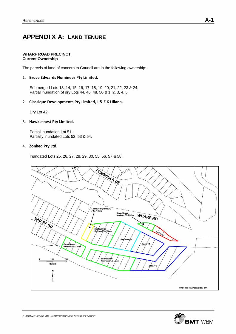
REFERENCES A-1
G:\ADMIN\B16690.G.MJA_WHARFROADCMP\R.B16690.002.04.DOC
APPENDIX A: LAND TENURE
WHARF ROAD PRECINCT Current Ownership The parcels of land of concern to Council are in the following ownership: 1. Bruce Edwards Nominees Pty Limited.
Submerged Lots 13, 14, 15, 16, 17, 18, 19, 20, 21, 22, 23 & 24. Partial inundation of dry Lots 44, 46, 48, 50 & 1, 2, 3, 4, 5.
2. Classique Developments Pty Limited, J & E K Uliana.
Dry Lot 42.
3. Hawkesnest Pty Limited. Partial inundation Lot 51. Partially inundated Lots 52, 53 & 54.
4. Zonked Pty Ltd.
Inundated Lots 25, 26, 27, 28, 29, 30, 55, 56, 57 & 58.

BMT WBM Brisbane Level 11, 490 Upper Edward Street Brisbane 4000
PO Box 203 Spring Hill QLD 4004 Tel +61 7 3831 6744 Fax +61 7 3832 3627 Email [email protected] Web www.wbmpl.com.au
BMT WBM Denver 14 Inverness Drive East, #B132 Englewood Denver Colorado 80112 USA Tel +1 303 792 9814 Fax +1 303 792 9742 Email [email protected] Web www.wbmpl.com.au
BMT WBM Melbourne Level 5, 99 King Street Melbourne 3000 PO Box 604 Collins Street West VIC 8007 Tel +61 3 8620 6100 Fax +61 3 8620 6105 Email [email protected] Web www.wbmpl.com.au
BMT WBM Morwell Cnr Hazelwood Drive & Miners Way Morwell 3840 PO Box 888 Morwell VIC 3840 Tel +61 3 5135 3400 Fax +61 3 5135 3444 Email [email protected] Web www.wbmpl.com.au
BMT WBM Newcastle 126 Belford Street Broadmeadow 2292 PO Box 266 Broadmeadow NSW 2292 Tel +61 2 4940 8882 Fax +61 2 4940 8887 Email [email protected] Web www.wbmpl.com.au
BMT WBM Perth 1 Brodie Hall Drive Technology Park Bentley 6102 Tel +61 8 9328 2029 Fax +61 8 9486 7588 Email [email protected] Web www.wbmpl.com.au
BMT WBM Sydney Suite 206, 118 Great North Road Five Dock 2046 PO Box 129 Five Dock NSW 2046 Tel +61 2 9713 4836 Fax +61 2 9713 4890 Email [email protected] Web www.wbmpl.com.au
BMT WBM Vancouver 1190 Melville Street #700 Vancouver British Columbia V6E 3W1 Canada Tel +1 604 683 5777 Fax +1 604 608 3232 Email [email protected] Web www.wbmpl.com.au