rapid biological inventories 15 - The Field...
103
PERÚ: MEGANTONI DICIEMBRE/DECEMBER 2004 1 rapid 15 biological inventories Perú: Megantoni Corine Vriesendorp, Lelis Rivera Chávez, Debra Moskovits y/and Jennifer Shopland, editores/editors DICIEMBRE/DECEMBER 2004 Instituciones Participantes / Participating Institutions The Field Museum Centro para el Desarrollo del Indígena Amazónico (CEDIA) Herbario Vargas, Universidad Nacional San Antonio Abad del Cusco Museo de Historia Natural de la Universidad Nacional Mayor de San Marcos Centro de Conservación, Investigación y Manejo de Áreas Naturales (CIMA-Cordillera Azul)
-
Upload
nguyenminh -
Category
Documents
-
view
213 -
download
0
Transcript of rapid biological inventories 15 - The Field...

PERÚ: MEGANTONI DICIEMBRE/DECEMBER 2004 1
rapid 15biological inventories
Perú: MegantoniCorine Vriesendorp, Lelis Rivera Chávez,
Debra Moskovits y/and Jennifer Shopland, editores/editors
DICIEMBRE/DECEMBER 2004
Instituciones Participantes /Participating Institutions
The Field Museum
Centro para el Desarrollo del Indígena Amazónico (CEDIA)
Herbario Vargas, UniversidadNacional San Antonio Abad del Cusco
Museo de Historia Natural de la Universidad Nacional Mayor de San Marcos
Centro de Conservación, Investigación y Manejo de Áreas Naturales(CIMA-Cordillera Azul)

RAPID BIOLOGICAL INVENTORIES INFORME / REPORT NO.152
LOS INVENTARIOS BIOLÓGICOS RÁPIDOS SON PUBLICADOS POR/
RAPID BIOLOGICAL INVENTORIES REPORTS ARE PUBLISHED BY:
THE FIELD MUSEUMEnvironmental and Conservation Programs
1400 South Lake Shore Drive
Chicago, Illinois 60605-2496 USA
T 312.665.7430, F 312.665.7433
www.fieldmuseum.org
Editores /Editors: Corine Vriesendorp, Lelis Rivera Chávez,
Debra Moskovits, Jennifer Shopland
Diseño /Design: Costello Communications, Chicago
Mapas /Maps: Dan Brinkmeier, Kevin Havener,
Sergio Rabiela, Jorge Rivera
Traducciones /Translations: Patricia Alvarez, Elizabeth Anderson,
Lydia Gentry, Walter Kategari Iratsimeri, Sarah Kaplan, Tatiana
Pequeño, Viviana Ruiz-Gutierrez, Miguel Chacami Shiompiki,
Amanda Zidek-Vanega, Tyana Wachter.
El Field Museum es una institución sin fines de lucro exenta de
impuestos federales bajo la sección 501 (c) (3) del Código Fiscal Interno. /
The Field Museum is a non-profit organization exempt from federal
income tax under section 501 (c) (3) of the Internal Revenue Code.
ISBN 0-914868-59-4
©2004 por el Field Museum. Todos los derechos reservados. /
©2004 by the Field Museum. All rights reserved.
Cualquiera de las opiniones expresadas en los Informes de los Inventarios
Biológicos Rápidos son expresamente las de los autores y no reflejan
necesariamente las del Field Museum. /Any opinions expressed in the
Rapid Biological Inventories Reports are those of the authors and do not
necessarily reflect those of The Field Museum.
Esta publicación ha sido financiada en parte por la
Gordon and Betty Moore Foundation. /This publication has been
funded in part by the Gordon and Betty Moore Foundation.
Cita Sugerida /Suggested Citation: C.Vriesendorp,
L. Rivera Chávez, D. Moskovits and Jennifer Shopland (eds.).
2004. Perú : Megantoni. Rapid Biological Inventories Report 15.
Chicago, Illinois : The Field Museum.
Créditos Fotográficos /Photography Credits
Carátula /Cover: Megantoni fue nombrado por el meganto
(Machiguenga para Guacamayo Militar, Ara militaris). Foto de
H. Plenge /Megantoni is named for the meganto (Machiguenga
for Military Macaw, Ara militaris). Photo by H. Plenge.
Carátula interior / Inner-cover: Megantoni protege una gran
diversidad de hábitats desde las húmedas selvas bajas (500 m)
hasta la puna (4000 m). Foto de H. Plenge. /Megantoni safeguards
a great diversity of habitats from humid lowlands (500 m) to
high-altidude grasslands (4000 m). Photo by H. Plenge.
Láminas a color /Color plates: Figs. 3C, 3K, 8A-H, M. Hidalgo;
Figs. 3D, 3F, 6B, 6P, C. Vriesendorp; Figs. 3E, 6F, 7A-C, 9E,
10A-B, 11A-C, 11E-F, 12A, H. Plenge; Figs. 3G-J, 4A-H, 5A-M,
6G-O, 6U, 6Y-DD, 6FF-GG, 6II, 6NN-VV, 12E, R. Foster;
Figs. 6A, 6E, 6Q-T, 6V-X, 6EE, 6HH-KK, 6MM, N. Salinas;
Figs. 6C, 9A-B, 9F-G, 11D, 13, G. Knell; Fig. 6D, J. Figueroa;
Figs. 9C, 9H, L. Rodríguez; Fig. 9D, A. Catenazzi;
Figs. 10C-E, D. Lane; Figs. 12B-D, L. Rivera
Impreso sobre papel reciclado. /Printed on recycled paper.

PERÚ: MEGANTONI DICIEMBRE/DECEMBER 2004 137
ENGLISH CONTENTS
(for Color Plates, see pages 21-40)
137 Table of Contents for English Text
138 Participants
140 Institutional Profiles
143 Acknowledgments
145 Mission
146 Report at a Glance
153 Why Megantoni?
155 Overview of Results155 New Species and Range Extensions
157 Findings at Each Inventory Site
160 Human Communities
160 Conservation Risks and Opportunities
162 Conservation Targets
165 Recommendations
171 Technical Report171 Overview of Inventory Sites
174 Overflight of Zona Reservada Megantoni
176 Flora and Vegetation
185 Dung Beetles
192 Fishes
199 Amphibians and Reptiles
204 Birds
215 Mammals
223 History of the Region and its Peoples223 Brief History of the Region
225 Socioeconomic and Cultural Characteristics
231 Appendices232 (1) Vascular Plants
259 (2) Dung Beetles
263 (3) Fish Sampling Stations
264 (4) Fishes
268 (5) Amphibians and Reptiles
274 (6) Birds
288 (7) Mammals
294 Literature Cited
300 Previous Reports

Hamilton Beltrán (plants)
Museo de Historia Natural
Universidad Nacional Mayor de San Marcos
Lima, Peru
Alessandro Catenazzi (amphibians and reptiles)
Florida International University
Miami, FL, USA
Judith Figueroa (mammals)
Asociación UCUMARI
Lima, Peru
Robin B. Foster (plants)
Environmental and Conservation Programs
The Field Museum, Chicago, IL, USA
Max H. Hidalgo (fishes)
Museo de Historia Natural
Universidad Nacional Mayor de San Marcos
Lima, Peru
Dario Hurtado (transport logistics)
Peruvian National Police
Lima, Peru
Guillermo Knell (field logistics)
Environmental and Conservation Programs
The Field Museum, Chicago, IL, USA
Daniel F. Lane (birds)
LSU Museum of Natural Science
Louisiana State University, Baton Rouge, LA, USA
Trond Larsen (dung beetles)
Ecology and Evolutionary Biology
Princeton University, Princeton, NJ, USA
Debra K. Moskovits (coordinator)
Environmental and Conservation Programs
The Field Museum, Chicago, IL, USA
Tatiana Pequeño (birds)
CIMA-Cordillera Azul
Lima, Peru
Heinz Plenge (photography)
Photo Natur, Lima, Peru
Roberto Quispe (fishes)
Museo de Historia Natural
Universidad Nacional Mayor de San Marcos
Lima, Peru
Norma Salinas Revilla (plants)
Herbario Vargas
Universidad Nacional San Antonio Abad de Cusco
Cusco, Peru
RAPID BIOLOGICAL INVENTORIES INFORME / REPORT NO.15138
PARTICIPANTS
FIELD TEAM

Dani Enrique Rivera (field logistics)
Museo de Historia Natural
Universidad Nacional Mayor de San Marcos
Lima, Peru
Lelis Rivera Chavéz (general logistics, social characterization)
CEDIA, Lima, Peru
Lily O. Rodríguez (amphibians and reptiles)
CIMA-Cordillera Azul
Lima, Peru
José-Ignacio (Pepe) Rojas Moscoso (field logistics)
Blinn College
College Station, TX, USA
Aldo Villanueva (field logistics)
Universidad Ricardo Palma
Lima, Peru
Corine Vriesendorp (plants)
Environmental and Conservation Programs
The Field Museum, Chicago, IL, USA
Patricio Zanabria (social characterization)
CEDIA, Lima, Peru
Instituto Nacional de Recursos Naturales (INRENA)Lima, Peru
Proyecto Especial de Titulación de Tierras y Catastro Rural (PETT) de Quillabamba
Machiguenga CommunitiesMatoriato
Timpía
Shivankoreni
Consejo Machiguenga del Río Urubamba (COMARU)
PERÚ: MEGANTONI DICIEMBRE/DECEMBER 2004 139
COLLABORATORS

The Field Museum
The Field Museum is a collections-based research and educational
institution devoted to natural and cultural diversity. Combining
the fields of Anthropology, Botany, Geology, Zoology, and
Conservation Biology, museum scientists research issues in
evolution, environmental biology, and cultural anthropology.
Environmental and Conservation Programs (ECP) is the branch
of the museum dedicated to translating science into action that
creates and supports lasting conservation. Another branch, the
Center for Cultural Understanding and Change, works closely with
ECP to ensure that local communities are involved in conservation
in positive ways that build on their existing strengths. With losses
of natural diversity accelerating worldwide, ECP's mission is to
direct the museum's resources—scientific expertise, worldwide
collections, innovative education programs—to the immediate
needs of conservation at local, national, and international levels.
The Field Museum
1400 South Lake Shore Drive
Chicago, Illinois 60605-2496 USA
312.922.9410 tel
www.fieldmuseum.org
Centro para el Desarrollo del Indígena Amazónico (CEDIA)
CEDIA is a non-governmental organization that has supported
Amazonian indigenous peoples for more than 20 years, principally
through land titling, seeking legal rights for indigenous groups,
and community-based resource management. They have titled
more than 350 indigenous communities, legally protecting almost
four million ha for 11,500 indigenous families. With an integral
vision of long-term territorial and resource management, CEDIA
supports organizational strengthening of indigenous groups
seeking to defend their territories and effectively manage their
natural resources and biodiversity. They work with several
indigenous groups including Machiguenga, Yine Yami, Ashaninka,
Kakinte, Nanti, Nahua, Harakmbut, Urarina, Iquito, and Matsés
in the Alto and Bajo Urubamba, Apurímac, Alto Madre de Dios,
Chambira, Nanay, Gálvez and Yaquerana watersheds.
Centro para el Desarrollo del Indígena Amazónico-CEDIA
Pasaje Bonifacio 166, Urb. Los Rosales de Santa Rosa
La Perla – Callao, Lima, Peru
51.1.420.4340 tel
51.1.457.5761 tel/fax
RAPID BIOLOGICAL INVENTORIES INFORME / REPORT NO.15140
INSTITUTIONAL PROFILES

Herbario Vargas (CUZ) de la Facultad de Ciencias Biológicas de la Universidad Nacional de San Antonio Abad del Cusco
Founded in 1936, Herbario Vargas protects and maintains plant
collections from throughout the region, serving as the botanical
reference for national and international researchers working in
and around Cusco. The more than 150,000 collections, along
with an extensive and specialized library, play an invaluable role
in floristic, taxonomic, and ecological studies of Peru’s diverse
vegetation types. Herbario Vargas forms part of the Biological
Sciences Division in the Universidad Nacional de San Antonio
Abad del Cusco, a 312-year-old university, one of the oldest in
Latin America.
Herbario Vargas (CUZ) de la Facultad de
Ciencias Biológicas de la Universidad Nacional
de San Antonio Abad del Cusco
Avenida De La Cultura 733
Cusco, Peru
51.84.23.2194 tel
http://www.unsaac.edu.pe/biologia.html
Museum of Natural History of the Universidad Nacional Mayor de San Marcos
Founded in 1918, the Museum of Natural History is the
principal source of information on the Peruvian flora and fauna.
Its permanent exhibits are visited each year by 50,000 students,
while its scientific collections—housing a million and a half plant,
bird, mammal, fish, amphibian, reptile, fossil, and mineral
specimens—are an invaluable resource for hundreds of Peruvian
and foreign researchers. The museum’s mission is to be a center
of conservation, education and research on Peru’s biodiversity,
highlighting the fact that Peru is one of the most biologically
diverse countries on the planet, and that its economic progress
depends on the conservation and sustainable use of its natural
riches. The museum is part of the Universidad Nacional Mayor
de San Marcos, founded in 1551.
Museo de Historia Natural
de la Universidad Nacional Mayor de
San Marcos
Avenida Arenales 1256
Lince, Lima 11, Peru
51.1.471.0117 tel
www.unmsm.edu.pe/hnatural.htm
PERÚ: MEGANTONI DICIEMBRE/DECEMBER 2004 141

Centro de Conservación, Investigación y Manejo de Áreas Naturales (CIMA-Cordillera Azul)
CIMA-Cordillera Azul is a private, non-profit Peruvian
organization that works on behalf of the conservation of
biological diversity. Our work includes directing and monitoring
the management of protected areas, promoting economic
alternatives that are compatible with biodiversity protection,
carrying out and communicating the results of scientific and social
research, building the strategic alliances and capacity necessary for
private and local participation in the management of protected
areas, and assuring the long-term funding of areas under
direct management.
CIMA-Cordillera Azul
San Fernando 537
Miraflores, Lima, Peru
51.1.444.3441, 242.7458 tel
51.1.445.4616 fax
www.cima-cordilleraazul.org
RAPID BIOLOGICAL INVENTORIES INFORME / REPORT NO.15142

PERÚ: MEGANTONI DICIEMBRE/DECEMBER 2004 143
ACKNOWLEDGMENTS
Although too numerous to thank individually, we are deeply
grateful to each and every person who made our work in
Megantoni possible, and to all who then translated our results
into the creation of a new National Sanctuary in Peru, the
Santuario Nacional Megantoni.
The indigenous communities that neighbor the now
Santuario Nacional Megantoni, worked for 22 years with CEDIA
to protect these spectacular mountains and their extraordinary
cultural and biological riches. We congratulate these communities
for their perseverance and we thank them for inviting us to
inventory the scientifically unexplored mountains. We especially
thank the communities of Timpía, Matoriato, and Shivankoreni,
who participated in the preparations, logistics, and execution of
the inventory.
The success of a rapid inventory in such remote and
inaccessible sites depends largely on the unwavering resolve of
the logistics team. We were blessed with an energetic group who
saw no challenge as insurmountable. Leading the advance team—
which set up ground logistics, heliports, campsites, trails—
was Guillermo Knell, with José-Ignacio (Pepe) Rojas and
Aldo Villanueva. Heading the intricate transportation logistics was
expert problem solver and superb helicopter pilot, Dario Hurtado.
The staff of CEDIA stepped in with coordination and other help at
every step, from support with radio communications to provision of
last-minute supplies. We thank the Hostal Alto Urubamba and the
Police Headquarters (Comisaría) in Quillabamba, especially
Major Walter Junes, for generously going out of their way a
number of times to support the team. Fritz Lutich and pilots
Roberto Arias and Ricardo Gutierrez (Helisur) facilitated the entry
of the advance team. The Peruvian National Police helped with
storage and logistics in-between flights. Pilot Daniel de la Puente
and engineer Juan Pablo San Cristobal (Copters Peru) tried hard
not to leave us stranded too often. And we owe special thanks to
Ing. Funes, of Techin, SA, for rescuing us when we did get
stranded, sending one of his busy helicopters to move us from
Kapiromashi (Camp 1) to Katarompanaki (Camp 2).
The first campsite, Kapiromashi, and trails were
masterfully set up under the coordination of Pepe Rojas and the
work of Timpía residents Filemon Olarte, Gilberto Martinez,
Javier Mendoza, Jaime Dominguez, Martin Semperi, Francisco
Garcia, and Beatriz Nochomi (cook). Guillermo Knell, with the
help of Dani Rivera, coordinated the stunning campsite on
the mossy plateau of the second camp, Katarompanaki, with the
skilled work of Jose Semperi, Valerio Tunqui, Felipe Semperi,
Cesar Mendoza, Antonio Nochomi, Wilber Yobeni, Pedro Korinti,
Rina Intaqui (cook), and Adolfo Nochomi, also residents of
Timpía. We thank the chief of Timpía, Camilo Ninasho, for his
support. The third and highest campsite, Tinkanari, was the
masterwork of Aldo Villanueva and his team from Matoriato—
Roger Yoyeari, Gilmar Manugari, Bocquini Sapapuari, Luis
Camparo, Samuel Chinchiquiti, Yony Sapapuari (cook), Patricio
Rivas, and Ronald Rivas—and from Shivankoreni, Miguel
Chacami and Esteban Italiano. We thank Delia Tenteyo and
René Bello for keeping all of us well fed in the field.
For help in species identification, the botany
team thanks Eric Christenson, Jason Grant, Charlotte Taylor,
Lucia Lohmann, James Luteyn, Andrew Henderson, Stefan Dressler,
Lucia Kawasaki, Bil Alverson, Jun Wen, Nancy Hensold, Paul Fine,
John Kress, and David Johnson. For help in drying specimens,
we thank Marlene Mamani, Karina Garcia, Natividad Raurau,
Angela Rozas, Vicky Huaman, William Farfan, Javier Silva,
Walter Huaraca, Darcy Galiano, and Guido Valencia. In Chicago,
Sarah Kaplan processed many of the images, and Tyana Wachter
lent her help and magic every step along the way.
Francois Genier helped identify dung beetles.
Richard Vari, Scott Schaefer, Mario de Pinna, and Norma Salcedo
helped with fish identifications, and Hernán Ortega reviewed the
fish manuscript. We thank Charles Myers, William Duellman,
David Kizirian, Roy McDiarmid, Michael Harvey, Diego Cisneros,
and especially Javier Icochea, for help in identification of reptiles
and amphibians. Dani Rivera actively participated in the
herpetological fieldwork, especially in Camp Katarompanaki.
Guillermo Knell, as always, participated in fieldwork and in the
photographing of the herpetofauna.
Constantino Aucca, Nathaniel Gerhart, Ross McLeod,
John O'Neill, J. V. Remsen, Thomas Schulenberg, Douglas Stotz,
Thomas Valqui, Barry Walker, and Bret Whitney all contributed
valuable comments to the bird manuscript. We thank Paul Velazco
and Marcelo Stucchi for their revisions of the mammal chapter.
The editors thank all authors for their efforts in writing
their chapters quickly and, especially, for their fast production of
summary charts as soon as we arrived in Cusco. These summaries

RAPID BIOLOGICAL INVENTORIES INFORME / REPORT NO.15144
ACKNOWLEDGMENTS
became the core of the presentation for requesting Santuario
Nacional status for the biologically rich mountains of Megantoni.
CEDIA’s team (especially Jorge Rivera) and Sergio Rabiela,
Dan Brinkmeier, and Kevin Havener were extremely helpful in
producing the maps for the report.
We thank Heinz Plenge (who joined us in the first
camp) for the use of his gorgeous photographs and Guillermo
Knell for his excellent videos in the field.
For invaluable help in final edits we thank Douglas
Stotz, and throughout the inventory, we thank Jorge Aliaga and
Malaquita Vargas in CIMA (Lima), and Tyana Wachter, Brandy
Pawlak, and Rob McMillan at The Field Museum (Chicago).
Tyana was also wonderful help with the translations. As always,
Jim Costello gave completely of himself to capture the essence of
this inventory in his design of the report. John W. McCarter, Jr.
continues to be a strong believer in, and supporter of, our
conservation programs. We thank the Gordon and Betty Moore
Foundation for their grant supporting this inventory.

PERÚ: MEGANTONI DICIEMBRE/DECEMBER 2004 145
During rapid biological inventories, scientific teams
focus primarily on groups of organisms that indicate
habitat type and condition and that can be surveyed
quickly and accurately. These inventories do not
attempt to produce an exhaustive list of species or
higher taxa. Rather, the rapid surveys 1) identify the
important biological communities in the site or region
of interest, and 2) determine whether these
communities are of outstanding quality and significance
in a regional or global context.
During social asset inventories, scientists and
local communities collaborate to identify patterns of
social organization and opportunities for capacity
building. The teams use participant observation and
semi-structured interviews to evaluate quickly the
assets of these communities that can serve as
points of engagement for long-term participation in
conservation. In-country scientists are central to the
field teams. The experience of local experts is crucial
for understanding areas with little or no history of
scientific exploration. After the inventories, protection
of natural communities and engagement of social
networks rely on initiatives from host-country scientists
and conservationists.
Once these rapid inventories have been
completed (typically within a month), the teams
relay the survey information to local and international
decisionmakers who set priorities and guide
conservation action in the host country.
MISSION
The goal of rapid biological and social inventories is to catalyze effective action for conservation in threatenedregions of high biological diversity and uniqueness.
Approach

RAPID BIOLOGICAL INVENTORIES INFORME / REPORT NO.15146
R E P O R T AT A G L A N C E
Dates of fieldwork April 25-May 13, 2004
Region The 216,005 hectares of intact forest in the Zona Reservada Megantoni (ZRM)
are situated along the eastern slopes of the Andes, in the department of Cusco
(province of Convención, district of Echarate) in the central part of the Urubamba
valley. The terrain is steep and spectacular, crossing different altitudinal gradients
ranging from deep, humid canyons to the highland grasses of the puna, with forests
growing on a heterogeneous mix of uplifted rocks, steep slopes, jagged mountain
ridges, and middle-elevation tablelands.
Two steep mountain ranges traverse stretches of the Zona Reservada, descending
from east to west. In the southwestern corner, the Río Urubamba bisects one of
these ranges, creating the mythical canyon, Pongo de Maenique. Three of the
Urubamba’s tributaries—the Río Timpía and the Río Ticumpinía from the north
and the Río Yoyato on the southern limit—run haphazardly through the deep valleys
in the Zona Reservada, carving a path among the towering ridges above them.
Sites surveyed We surveyed three sites between 650-2,350 m. Although lowland forests harbor
many more species, higher elevations tend to support more endemic species
and species with restricted ranges. We chose the most inaccessible and isolated
sites possible.
Kapiromashi Camp (bamboo in Machiguenga): This was the only inventory site
in a large river valley. Our camp was situated in a regenerating landslide, along
a small creek about 200 m from the Río Ticumpinía. The Río Ticumpinía, one of
the largest rivers in the ZRM, reaches widths of 150 m or more during the rainy
season. Similar to other areas in Megantoni, bamboo is pervasive at this site.
We surveyed forests growing at elevations between 650-1,200 m.
Katarompanaki Camp (Clusia in Machiguenga): At the heart of Zona Reservada
Megantoni, several massive tablelands rise between two tributaries of the
Río Ticumpinía. These tablelands are obvious on satellite images and do not appear
in either Parque Nacional Manu or the Vilcabamba conservation complex. Our
second campsite was on the highest of these tablelands, and we explored both this
higher tier and another platform 400 m below it. This campsite was christened
Katarompanaki for the Clusia tree species that dominates the canopy on the top
tier of the tablelands. At this camp we surveyed elevations between 1,300-2,000 m.
R E P O R T AT A G L A N C E

R E P O R T AT A G L A N C E
Tinkanari Camp (tree fern in Machiguenga): Our third inventory site was in the
eastern corner of the Zona Reservada, close to its border with Parque Nacional
Manu. Throughout the Andes and in parts of the Zona Reservada, this elevation
contains some of the steepest slopes. This site was atypically flat, however, with
water pooling in several places in the forest, and even forming a small (20-m
diameter) blackwater pond that was not visible on the satellite image. The
headwaters of the Río Timpía and the Río Manu originate several hundred meters
above this site, and our trails crossed dozens of small creeks with moss-covered
rocks. At this camp, we surveyed between the elevations of 2,100 and 2,400 m.
Organisms studied Vascular plants, dung beetles, fishes, reptiles and amphibians, birds, and
large mammals.
Results highlights The biological communities in Zona Reservada Megantoni are an interesting mix of
species from north and south, east and west. Prior to our fieldwork, we expected to
find a mix of components from the adjacent protected areas, Parque Nacional Manu
and Cordillera Vilcabamba. The avifauna fit our expectations, and was a mix of these
areas, but the other organisms were more closely related to communities in Manu,
and some species occur exclusively in Megantoni. During our three-week field survey,
we found more than 60 species new to science (more than 20 were orchids)—which
is extraordinary. Habitat diversity in the Zona Reserva is extremely high.
Plants: The team registered more than 1,400 species, and we estimate that
3,000-4,500 plant species occur in the entire Zona Reservada, including lowland
forest and puna species. In just 15 days, we found a surprising number of species
new to science: 25 to 35. Great habitat diversity exists in the region and several
plant species have very restricted ranges, confined to a certain type of soil
or bedrock; these conditions may in part drive speciation. Orchids and ferns are
especially diverse in the Zona Reservada and represent one quarter of all the plant
species observed. Approximately one fifth of the flowering orchids we found were
new to science (20 of 116 species).
Dung beetles: The team registered 71 of the 120 estimated dung beetles for the
Zona Reservada. We found very few species in more than one site (and when
we did, the species abundance was much greater in one site than the other).
Species richness is exceptionally high in the region, even more so than in similar
elevations in the Valle Kosñipata (Parque Nacional Manu). The two highest
elevations we surveyed had great abundance of large dung beetles, which are
more vulnerable to extinction. Secondary forests and bamboo forests had fewer
species. Many of the species found have restricted elevational (and probably
Sights Surveyed
(continued)
PERÚ: MEGANTONI DICIEMBRE/DECEMBER 2004 147

RAPID BIOLOGICAL INVENTORIES INFORME / REPORT NO.15148
geographic) ranges and are most likely endemic to the region. Some of the
Pharaeires species found were just recently described for science, some are rare,
and some are new to science. In ecological terms the larger species are especially
important because they recycle waste, control parasites, and disperse seeds.
Fish: In the Río Ticumpinía and numerous smaller creeks, the team registered
22 fish species. We estimate that the ichthyofauna in Zona Reservada Megantoni
exceeds 70 species, the majority living in the waters of lowland forests (< 700 m)
not visited during this inventory. Some of the highland species (Astroblepus and
Trichomycterus) appear endemic to the area, with unique morphological
adaptations to the turbulent waters of the region. All sampled aquatic habitats
are in an excellent state of conservation, free of the introduced rainbow trout
(Oncorhynchus mykiss) that has displaced (and in some cases, driven to extinction)
native fauna in other sites in the Peruvian Andes.
Reptiles and amphibians: The herpetologist team registered 32 amphibian species
(anurans) and 19 reptiles (9 lizards and 10 snakes) in three inventory sites between
700 and 2200 m. Based on previous inventories along the same altitudinal transect
in the Valle Kosñipata (Parque Nacional Manu), we estimate 50-60 amphibians
occur within Zona Reservada Megantoni. We found some species in unexpected
elevations (Phrynopus lower than expected and Epipedobates macero higher) and
some outside of their expected geographic ranges (e.g., Syncope further south,
Liophis problematicus further north). Zona Reservada Megantoni shares some of
the herpetofauna with neighboring Parque Nacional Manu, but more than a fifth
of the species we recorded are unique to Megantoni. We found 12 species new to
science (7 amphibians, 4 lizards, and 1 snake).
Birds: The ornithologist team registered 378 species in the three inventory sites.
Including species from unvisited habitats (lowland tropical forest, high montane
forest, and puna) and migratory species, we estimate 600 bird species occur within
Zona Reservada Megantoni. The avifauna was a mix of species from the central
Peruvian Andes, some only recorded west of Cordillera Vilcabamba, and species
from the Bolivian Yungas, some only recorded from Puno or on the eastern side
of Parque Nacional Manu. Protecting this area would preserve the remarkably
high densities of guans and macaws we observed during this inventory. In other
parts of Peru, hunting of large birds, like guans and tinamous, has seriously
reduced their abundance. Even in our first camp (Kapiromashi), we found signs
of hunting and guans were notably scarcer. Extremely rare and local species such
as Black Tinamou (Tinamus osgoodi), Scimitar-winged Piha (Lipaugus uropygialis)
and the Selva Cacique (Cacicus koepckeae), which are vulnerable to extinction
R E P O R T AT A G L A N C E
Results Highlights
(continued)

R E P O R T AT A G L A N C E
(Birdlife International) and inhabit few sites worldwide, would be protected
in Megantoni.
Mammals : Of the 46 expected species, the team registered 32 large and
medium mammal species (belonging to 7 orders and 17 families) during the
inventory. Five of these species are considered endangered and 12 are considered
potentially threatened according to the Convention on International Trade in
Endangered Species (CITES). In the three sites we found a large number of tracks
and other signs of the spectacled bear (Tremarctos ornatus), indicating the presence
of healthy populations and further stressing the importance of protecting the
Megantoni corridor. The Zona Reservada Megantoni is likely an extremely
important corridor for other migrating species, such as Panthera onca and Puma
concolor. Conservation targets include mammals listed on CITES, Appendix I :
Tremarctos ornatus, Panthera onca, Leopardus pardalis, Lontra longicaudis and
Priodontes maximus; and on CITES Appendix II : Myrmecophaga tridactyla,
Dinomys branickii, Herpailurus yagouaroundi, Puma concolor, Tapirus terrestris,
Alouatta seniculus, Cebus albifrons, Cebus apella, Lagothrix lagothricha,
Tayassu pecari and Pecari tajacu.
Human communities There are 38 native communities representing four distinct ethnicities in the
upper and lower Urubamba river basins, north and south of Megantoni. The
Machiguenga, Ashaninka, Yine Yami, and Nanti have lived in these forests for
thousands of years hunting, fishing, and cultivating their small farms. For many
of them, their spiritual roots are centered in Megantoni, especially in the turbulent
waters of Pongo de Maenique—the sacred place where spirits travel between this
world and the next, and where the world was created. Twenty-two years ago,
the indigenous people of the region formed an alliance with CEDIA to promote
effective natural resource management and protect their land, its biodiversity,
and the center of their spiritual world. South of Megantoni, more than 150,000
colonist settlers live in the Alto Urubamba drainage.
Main threats Along both sides of the lower Urubamba there is substantial deforestation,
with larger slash and burn plots obvious on the satellite image, and evidence of
colonization disappearing only at the boundary of the proposed reserve. Upriver
of the Pongo de Maenique, and along the Río Yoyato on the southern side of the
proposed Zona Reservada, the colonization threat from higher in the Andes is
even greater, with the canyon appearing to provide at least a partial barrier to
deforestation. In addition to habitat destruction, uncontrolled hunting within
ZRM could threaten much of its fauna. We observed evidence of hunting impacts
in our first camp, Kapiromashi.
Results Highlights
(continued)
PERÚ: MEGANTONI DICIEMBRE/DECEMBER 2004 149

RAPID BIOLOGICAL INVENTORIES INFORME / REPORT NO.15150
In 1988, CEDIA (Centro del Desarrollo del Indígena Amazónico) and COMARU
(Consejo Machiguenga del Río Urubamba) appealed to the Ministry of Agriculture
to declare Megantoni a protected area (210,000 ha). In 1992, they prepared a
technical document calling for the creation of a strictly protected area in
Megantoni, “Santuario Nacional Machiguenga Megantoni.” In 1998, INRENA
passed responsibility to the Dirección Regional Agraria de Cusco (Regional
Agricultural Office in Cusco) to produce information about species listed by CITES,
and describe the lands neighboring the proposed protected area.
Between 1997 and 1998, the Inca Region, now known as the Cusco Regional
Government, assembled local institutions to form a sustainable development plan
for the entire Lower Urubamba drainage. This assembled groups strongly urged
completing all pending studies before officially declaring Zona Reservada
Megantoni a protected area.
In March 2004, 16 years after CEDIA began its work to protect the area, the
government passed Ministerial Resolution Number 0243-2004-AG creating
Zona Reservada Megantoni and incorporating it into the National System of
Natural Protected Areas (SINANPE).
Current Status The results of this inventory provided biological support for maximum protection
of the Zona Reservada (a temporary designation with limited protection).
On August 11, 2004, Supreme Decree Number 030-2004-AG created the new
Santuario Nacional Megantoni based on the technical documents prepared by
CEDIA, incorporating our findings. The Santuario is now an essential component
of Peru’s extensive, protected biological corridor that starts in Vilcabamba, crosses
Manu and Bahuaja-Sonene and then continues into Bolivia.
Megantoni
R E P O R T AT A G L A N C E
Antecedents to ZonaReservada Megantoni

R E P O R T AT A G L A N C E
01 Zona Reservada Megantoni should be granted the strongest protection status
possible to conserve its valuable cultural and biological resources, including species
potentially endemic to Megantoni’s mountains, and to maintain the extremely
important corridor between Parque Nacional Manu and Cordillera Vilcambamba.
[Note: This recommendation has already been implemented, with the creation of
the Santurio Nacional Megantoni as this report was being finalized.]
A. Within the new conservation area, we propose the following zoning
recommendations:
i. Protect the area where indigenous people in voluntary isolation live,
for their exclusive use (Uso Exclusivo)
ii. Create a special use (Uso Especial) area for the indigenous people living in
Sababantiari that allows them to continue their traditional use of the forest.
In this area, we recommend implementing a participatory community
program, to monitor the impact of hunting, and if necessary, to manage
hunting practices accordingly.
iii. The isolated puna habitat in the southeastern corner of Megantoni (see
map above) should be strictly protected. Because it is isolated from the more
extensive and interconnected puna habitat in other parts of Megantoni and
PN Manu, it could harbor endemic and rare species.
iv. Promote and ensure possibilities to research intact puna habitats along
the Zona Reservada’s southern border; these studies could eventually help
restore and manage degraded puna in nearby areas.
v. Promote a low-impact tourism zone around Pongo de Maenique and other
possible entrance points (e.g., north of the Estrella highway) to benefit
neighboring communities (see map).
02 Promote the completion of the physical and legal land titling in the areas next
to the Zona Reservada Megantoni.
03 Prevent public works or infrastructure construction within the fragile
Zona Reservada.
04 Develop engaging and effective ways for neighboring populations to participate
in the protection and management of the new protected area.
PERÚ: MEGANTONI DICIEMBRE/DECEMBER 2004 151
Principal recommendations for protection andmanagement

RAPID BIOLOGICAL INVENTORIES INFORME / REPORT NO.15152
Long-term conservation benefits
There are very few pristine areas like Zona Reservada Megantoni connecting
puna to lowland tropical forest. These types of continuous corridors not only
contain an impressive richness of both endemic species and species of restricted
altitudinal range, but they are extremely important for fauna, especially when
considering global issues of climate change and deforestation.
Zona Reservada Megantoni represents a unique opportunity to expand
some of the most globally important biological and cultural reserves: the
Parque Nacional Manu and the protected areas of the Cordillera Vilcabamba.
Immediate protection of these approximately 200,000 ha would provide an intact,
forested link between two tremendously important national parks, making the
total effective area of protection double the size of each individual park (a total
area of more than 2.6 million ha).
Elevating the status of the Zona Reservada to Santuario Nacional Megantoni
would ensure protection of thousands of species, prevent advancing deforestation,
and create the only secure and intact corridor for animals migrating between
Manu and Vilcabamba. The forests of Santuario Nacional Megantoni will also
support and provide shelter to the Machiguenga, Ashaninka, Yine Yami and Nanti
(Kugapakori) people. These indigenous people have lived in Megantoni’s forests
and valleys for thousands of years and today they survive cultivating root crops,
and hunting in the traditional manner of their ancestors. A strictly protected area
would also preserve their cultural heritage.
R E P O R T AT A G L A N C E

PERÚ: MEGANTONI DICIEMBRE/DECEMBER 2004 153
Megantoni is a critical piece of the conservation puzzle in southeastern Peru. Seated on
the eastern slopes of the Peruvian Andes, it fits snugly between two of the largest protected
areas in Peru: Parque Nacional Manu (1.7 million hectares) and the conservation complex
in Cordillera Vilcabamba (Reserva Comunal Machiguenga, Parque Nacional Otishi,
Reserva Comunal Ashaninka: total area 709,347 hectares).
With 216,005 hectares Megantoni may appear small compared to its neighbors,
but in rugged terrain spanning 500-4,000 meters in elevation, along steep slopes marked
by massive landslides, in waters flowing through deep river gorges, on jagged mountain
ridges and in nearly impenetrable patches of native bamboo, the wilds of Megantoni harbor
an astonishing diversity of life. Conservative estimates place Megantoni’s plant diversity
between 3,000-4,500 species, indicating that its forests may contain almost a quarter of the
plant species in Peru. Many birds and mammals threatened elsewhere in Peru and South
America find refuge here, and endemic species abound, around 20% of the frogs and fishes
living in Megantoni do not occur anywhere else in the world.
According to the mythology of the traditional inhabitants of the region — the
Machiguenga, Ashaninka, Nanti, and Yine Yami (Figure 12) — the abundant flora and fauna
are protected by Tasorinshi Maeni, the spectacled bear (Tremarctos ornatus, Figure 11B).
Indigenous peoples have lived in these forest valleys for millennia by cultivating root crops and
hunting with bows and arrows, and their lives and fates are intimately linked to Megantoni’s
wildlife and forests.
Megantoni offers the unique opportunity to link two biodiversity giants, securing
protection not only to the diverse biological and cultural communities of Megantoni,
but to a continuous expanse of more than 2.6 million hectares. Ill-planned colonization from
the south, and gas exploration and deforestation in the north threaten the Megantoni corridor.
This one-time chance to preserve intact one of the richest portions of the world depends
on the fast action and long-term vision of Megantoni’s local inhabitants, its supporting
organizations, and the Peruvian government.
Why Megantoni?


PERÚ: MEGANTONI DICIEMBRE/DECEMBER 2004 155
Overview of ResultsOverview of Results
Before setting foot in the forests of Zona Reservada Megantoni (ZRM) on the
eastern slopes of the Andes, we knew that our rapid inventory would focus on some
of the most diverse biological communities on the planet. The Andes shelter nearly
15% of the world’s plant diversity and almost 20% of the world’s terrestrial
vertebrates (~3,200 species). These mountain ranges are known not only for their
species richness but also for their unique and undescribed taxa: close to half of the
Andean flora and fauna is considered endemic, i.e., occurring nowhere else on Earth.
Megantoni fits the Andean mold. During our rapid inventory of its forests
in April-May 2004, we catalogued nearly 2,000 species: many endemic to the
region, several threatened or vulnerable in other parts of their range, and 60-80
new to science. Herpetologists found 7 new species of frogs; ichthyologists
discovered endemic fishes clinging to rocks in turbulent streams; entomologists
uncovered at least 30 new species of dung beetles; and botanists catalogued 1,400
plant species, including more than 400 species of orchids and ferns, with some 25
species new to science. Animals threatened in other parts of South America—
including spectacled bears, tapirs, and jaguars—commonly roam the Megantoni
landscape. Game birds, such as guans and tinamous, are remarkably abundant.
In the following sections we summarize the principal results of our rapid
inventory within ZRM. We highlight the new species discovered in Megantoni
and, for known species, the range extensions we documented during the inventory.
Starting from the lowest site and moving uphill, we describe our findings at the
three inventory sites, integrating information from all organisms sampled. Finally,
we outline the region’s assets, and the threats to its biological and cultural riches.
NEW SPECIES AND RANGE EXTENSIONS
NEW SPECIES
Before our inventory, Megantoni was almost entirely unknown to scientists, and
during our rapid inventory, we encountered many of the species we suspected
would live here. However, some of our finds were entirely unexpected (Table 1).
For every 100 plant species we recorded, 2 are probably species new to science;
for every 10 dung beetles, 1 to 4 are probably new; for every 10 fishes, 1 or 2

RAPID BIOLOGICAL INVENTORIES INFORME / REPORT NO.15156
are probably new; for every 10 amphibians or 10 reptiles,
2 are probably new. For a 15-day inventory, these are
impressive numbers and hint at the species richness that
remains to be documented in the wilds of Megantoni.
We discovered almost all of the potentially new
species at our two higher-elevation campsites, with the
exception of 1 Osteocephalus frog and ~8 new dung
beetles that were found in the lowlands. For plants, the
bulk of potentially new species are orchids; preliminary
impressions suggest that perhaps 20 of the 116 fertile
orchids collected are new to science (see Flora and
Vegetation, Figure 6). Based on digital photographs we
took in the field, specialists have tentatively identified 9
additional plant species, from 9 different families, as
new to science.
Many of the 22 fish species we registered
during the inventory are endemic to Megantoni. In
particular, some species in the families Astroblepidae
and Trichomycteridae have almost certainly undergone
speciation within the isolated watersheds of Megantoni.
At least 3 species we collected are new to science, including
Cetopsis sp. (Figure 8G), Chaetostoma sp. B (Figure 8A),
and Astroblepus sp. C (Figure 8D). Several species within
the Trichomycteridae are potentially new as well.
We encountered 51 species of amphibians
and reptiles. Slightly more than 20% are new to science:
7 anurans, 4 lizards, and 1 snake. The new amphibian
species include an Osteocephalus (Figure 9E), a
Phrynopus, at least 1 new species of Eleutherodactylus,
a Centrolene (Figure 9H), a Colostethus, a Gastrotheca
(Figure 9F), and a Syncope. We also discovered a new
species of snake (Taeniophallus, Figure 9D) on the
mid-elevation slopes and 4 new species of lizards
(Alopoglossus [Figure 9C], Euspondylus, Neusticurus,
and Proctoporus) living on the isolated tablelands in the
heart of Megantoni.
RANGE EXTENSIONS
Our inventory in Megantoni registered some species
that were previously known only from areas more than
500 km away, as well as some species at much higher or
lower elevations than previously recorded. Other groups
are so poorly known for the rest of the region (e.g.,
dung beetles, fishes) that more data need to be collected
before we can draw conclusions about endemism or
range extensions.
For plants, amphibians, reptiles, birds, and
mammals, we can compare some of our Megantoni
findings to records from other sites in Peru and
elsewhere in South America. As we continue to examine
our collections and to research published reports from
other sites, we expect to uncover even more geographic
and elevational range extensions within the biological
communities of Megantoni.
Plants
For plants, several collections in Megantoni extend
the known ranges of species hundreds of kilometers
farther south. At our low-elevation campsite,
Kapiromashi, we registered Wercklea ferox (Malvaceae)
for the first time in southern Peru. At the two higher
campsites, we found Ceroxylon parvifrons (Arecaceae),
Tapeinostemon zamoranum (Gentianaceae, Figure 4B),
Sarcopera anomala (Marcgraviaceae), Macleania
floribunda (Ericaceae), Miconia condylata
(Melastomataceae), and Peltastes peruvianus
(Apocynaceae, Figure 4D), all previously known only
from northern Peru.
Table 1. Species richness (observed and estimated) and the
number of species potentially new to science for each group
sampled during the 25 April-13 May 2004 rapid inventory in
Zona Reservada Megantoni, Peru. Missing records are represented
with a dash (–).
Number of Species
Observed Estimated PotentiallyOrganism New
Plants 1,400 3,000-4,000 25-35
Dung Beetles 71 120 10-30
Fishes 22 70 3-5
Amphibians 32 55 7
Reptiles 19 – 5
Birds 378 600 –
Mammals 32 45 –

Our collection of Heliconia robusta
(Heliconiaceae) fills a large gap in the knowledge of its
distribution. Known mostly from Bolivia, it has been
collected only a handful of times in Peru, always in sites
north of Megantoni. This Heliconia, with triangular
green and red bracts and yellow flowers, dominated parts
of the naturally disturbed forest around Kapiromashi.
Amphibian and reptiles
Our inventory increased the known geographic and
elevational distributions of several species and even a
few genera. At Megantoni we noted the southernmost
distributional record in Peru for Syncope, and the lowest
elevation recorded for Phrynopus and Telmatobius.
We also registered an apparently undescribed species
of Neusticurus, recorded previously from Santa Rosa
(~800 m asl), in the Inambari basin, Puno Department,
some 230 km southeast of Megantoni.
At Kapiromashi we found Epipedobates macero
(Figure 9G), a rare poison dart frog restricted to the Río
Purús in Brazil, Parque Nacional Manu, and the rivers in
the Urubamba valley. This record extends its elevational
range to 800 m from the previous record of 350 m where
the species was described in Manu. While sampling in the
leaf litter, we discovered a small Phrynopus cf. bagrecito,
known from higher elevations in Manu but never before
reported from such low elevations (~2,200 m asl).
Birds
We encountered bird species outside their published
elevational ranges at every inventory site. Our records in
Megantoni extend distributional limits for some species
farther south, for others farther north. Three birds
deserve special mention: Scimitar-winged Piha (Lipaugus
uropygialis, Figure 10D), Selva Cacique (Cacicus
koepckeae, Figure 10E), and Black Tinamou (Tinamus
osgoodi, Figure 10C). All three species are remarkably
abundant in parts of Megantoni, although exceedingly
uncommon worldwide. Our records substantially increase
our understanding of the distribution of these rare birds.
Our record of Scimitar-winged Piha is the
second for Peru; it was previously known only from
Abra Marancunca in Puno Department. From Puno,
the species occurs eastward along the humid Bolivian
yungas to Cochabamba Department (Bryce et al., in
press). Our record is a range extension of more than
500 km to the northwest and suggests the species may
occur along other mountain ranges in Cusco and Puno
Departments, such as within Parque Nacional Manu.
At Kapiromashi we registered Selva Cacique,
a species described from Balta, Ucayali Department, by
Lowery and O’Neill in 1965, and essentially unknown
until rediscovered by Gerhart near Timpía (Schulenberg
et al. 2000; Gerhart, 2004; Figure 1, A13). Ours is one
of a handful of sightings, and the highest elevational
record for the species.
Black Tinamou has a highly spotty
distribution in the Andes, with scattered records from
Colombia, Ecuador, Peru, and Bolivia. This species
was common at our two high elevation sites, and our
records fill one of the many large gaps in our knowledge
of its distribution.
Mammals
We observed a group of four brown capuchin
(Cebus apella) individuals at an elevation of 1,760 m.
This record is 260 m higher than the elevational range
reported by Emmons and Feer (1999).
FINDINGS AT EACH INVENTORY SITE
During our 15-day inventory, we explored three sites
ranging from 650 to 2,400 m in elevation, all different
from one another in topography, geology, and species
composition. As expected, we encountered the greatest
species richness in our low-elevation site, Kapiromashi,
(Table 2), and, as we climbed higher, we recorded
more endemics and more new species. Collectively our
findings sketch a preliminary picture of a highly diverse
and heterogeneous region, where habitat types vary on
scales small enough that one can walk through stunted,
epiphyte-laden forests on rock outcrops, to tall forests
on fertile soils, in less than an hour.
In the following sections we present a summary
of our major findings, focusing on each inventory site,
PERÚ: MEGANTONI DICIEMBRE/DECEMBER 2004 157
rather than on individual taxonomic groups as in the
Technical Report (page 171). Although our inventory
covered only a subset of the topographic and geological
diversity in Megantoni, we believe that our inventory
sites are representative of other areas within ZRM, and
that the differences among them are representative of
larger-scale patterns within the region.
Lower mountain slopes
(Kapiromashi, 650-1,200 m)
At this site in the Río Ticumpinía valley, we camped
200 m from the main river channel and explored the
forested slopes on either side of the river, the large river
island, the river itself, and several of its tributaries.
Recent landslides, and forests regenerating on old
landslides, are obvious features of the landscape.
They reminded us that the area is geologically active
and that natural disturbance to biological communities
is frequent throughout the region. Lower-elevation sites
exist in the ZRM (~500 m). Kapiromashi (650-1,200
m), however, was the lowest elevation we sampled.
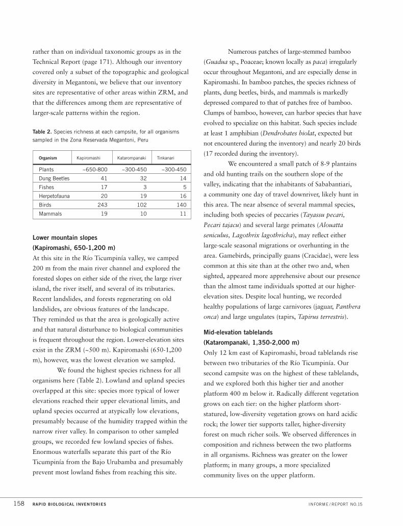
We found the highest species richness for all
organisms here (Table 2). Lowland and upland species
overlapped at this site: species more typical of lower
elevations reached their upper elevational limits, and
upland species occurred at atypically low elevations,
presumably because of the humidity trapped within the
narrow river valley. In comparison to other sampled
groups, we recorded few lowland species of fishes.
Enormous waterfalls separate this part of the Río
Ticumpinía from the Bajo Urubamba and presumably
prevent most lowland fishes from reaching this site.
Numerous patches of large-stemmed bamboo
(Guadua sp., Poaceae; known locally as paca) irregularly
occur throughout Megantoni, and are especially dense in
Kapiromashi. In bamboo patches, the species richness of
plants, dung beetles, birds, and mammals is markedly
depressed compared to that of patches free of bamboo.
Clumps of bamboo, however, can harbor species that have
evolved to specialize on this habitat. Such species include
at least 1 amphibian (Dendrobates biolat, expected but
not encountered during the inventory) and nearly 20 birds
(17 recorded during the inventory).
We encountered a small patch of 8-9 plantains
and old hunting trails on the southern slope of the
valley, indicating that the inhabitants of Sababantiari,
a community one day of travel downriver, likely hunt in
this area. The near absence of several mammal species,
including both species of peccaries (Tayassu pecari,
Pecari tajacu) and several large primates (Alouatta
seniculus, Lagothrix lagothricha), may reflect either
large-scale seasonal migrations or overhunting in the
area. Gamebirds, principally guans (Cracidae), were less
common at this site than at the other two and, when
sighted, appeared more apprehensive about our presence
than the almost tame individuals spotted at our higher-
elevation sites. Despite local hunting, we recorded
healthy populations of large carnivores (jaguar, Panthera
onca) and large ungulates (tapirs, Tapirus terrestris).
Mid-elevation tablelands
(Katarompanaki, 1,350-2,000 m)
Only 12 km east of Kapiromashi, broad tablelands rise
between two tributaries of the Río Ticumpinía. Our
second campsite was on the highest of these tablelands,
and we explored both this higher tier and another
platform 400 m below it. Radically different vegetation
grows on each tier: on the higher platform short-
statured, low-diversity vegetation grows on hard acidic
rock; the lower tier supports taller, higher-diversity
forest on much richer soils. We observed differences in
composition and richness between the two platforms
in all organisms. Richness was greater on the lower
platform; in many groups, a more specialized
community lives on the upper platform.
RAPID BIOLOGICAL INVENTORIES INFORME / REPORT NO.15158
Table 2. Species richness at each campsite, for all organisms
sampled in the Zona Reservada Megantoni, Peru
Organism Kapiromashi Katarompanaki Tinkanari
Plants ~650-800 ~300-450 ~300-450
Dung Beetles 41 32 14
Fishes 17 3 5
Herpetofauna 20 19 16
Birds 243 102 140
Mammals 19 10 11

Specialization was most obvious in fishes.
Fast-flowing streams feed the dramatic waterfalls that
pour over the sheer edge of the tablelands into the river
gorges below. Few fish species live in these streams, but
the three endemics we registered during the inventory
are abundant and uniquely adapted to the turbulent
waters, using their adhesive mouths to cling to rocks,
and their ventral muscles to pull their bodies upstream
against the current.
As did the specialists in fishes and dung beetles,
herpetologists found few species but many endemics.
Nutrient-poor forests are generally unfavorable habitats
for amphibians and reptiles, and on the upper platform
the team found only 16 species: 8 anurans, 3 lizards,
and 3 snakes. Nearly half, however, are species
potentially new to science—3 lizards (Euspondylus,
Neusticurus, Proctoporus) and 3 frogs (Centrolene,
Eleutherodactylus, Syncope)—suggesting that these
isolated tablelands could drive evolution in fishes, frogs,
lizards, and dung beetles in similar ways.
Plant diversity—concentrated in trees and
shrubs in Kapiromashi and on the lower platform of
Katarompanaki—shifted to smaller lifeforms on the
upper platform at Katarompanaki. Here, the highest
richness was concentrated in epiphytes and trunk
climbers, particularly orchids and ferns. Of the 275
fertile specimens on the tablelands, a quarter were
orchids, including about 15 species new to science.
In other areas of Peru (e.g., Cordillera del
Cóndor, Cordillera Azul), stunted forests support a suite
of specialized bird species, but we did not encounter
these elfin-forest specialists at Katarompanaki.
Ornithologists documented only moderate numbers of
bird species at this site, although the densities of game
birds, particularly the typically rare Black Tinamou,
were extraordinarily high.
We found numerous signs of spectacled bear
(Tremarctos ornatus) in the stunted forest, including
trails, dens, and discarded and half-eaten palm stems.
Our Machiguenga guides estimated that bears were in
the area three months prior to our visit, confirming
other research that suggests these animals travel widely
through large territories, tracking seasonal fluctuations
in food abundance.
On the lower platform, species richness in all
groups was much higher, although researchers spent
less time investigating this area. Most notable were the
abundance of fruiting trees and the extraordinary densities
of woolly monkeys (Lagothrix lagothricha) feeding on
them, including an enormous group of 28 individuals.
We believe humans have never visited this site
before. Reaching the tablelands without a helicopter
appears nearly impossible.
Mid-elevation slopes
(Tinkanari, 2,100-2,400 m)
Our third inventory site was in the western corner of
the Zona Reservada, close to its junction with Parque
Nacional Manu (Figure 3B). The headwaters of the
Río Timpía and the Río Manu originate several hundred
meters above this site, and our trails crossed dozens of
small creeks with moss-covered rocks (Figure 3K). This
site was atypically flat, however, with water pooling in
several places in the forest and forming boggy areas.
As at Katarompanaki camp, we distinguished
two forest types at this site. A tall forest on richer soils
dominates 90% of the area and surrounds a neatly
delimited area (~0.5 km2) of stunted shrub forest
growing on a much harder acidic rock. The stunted
shrub forest was obvious from the air and was similar
to other outcrops on acidic rock seen during the
overflights of the Zona Reservada.
Signs of spectacled bear were common and
widespread in the stunted forest and ranged from
trails and dens to recent food remains and fresh scat.
Spectacled bears were one of the most abundant
mammals we recorded in Megantoni, second only to
woolly monkeys. Moreover, our Megantoni surveys
recorded the highest relative density of spectacled bear
reported in any Peruvian inventory.
Again, game birds were abundant and tame,
including Sickle-winged Guan (Chamaepetes goudotii),
Wattled Guan (Aburria aburri), and Andean Guan
(Penelope montagnii). At this site, ornithologists
photographed Scimitar-winged Piha (see Range
PERÚ: MEGANTONI DICIEMBRE/DECEMBER 2004 159

Extensions, above) and tape-recorded calls and a
flight display. We believe this flight display has never
been witnessed before.
We found several new species and range
extensions for plants at this site. Ferns dominated these
forests (Figure 5) with high richness (~30 species/100 m2)
and high densities, especially of tree ferns (~2,000
individuals/ha). As in the Katarompanaki tablelands,
species richness was concentrated in epiphytes rather
than trees and shrubs.
Amphibians and reptiles showed patterns of
diversity parallel to those of fishes, as they did at
Katarompanaki. Species richness was limited overall,
but several novelties and endemics dominated the
community. Ichthyologists found high fish densities in
all streams sampled, registering 5 species of fishes,
including 2 Astroblepus not found at Katarompanaki.
Herpetologists recorded 10 species of anurans, 2 lizards,
and 4 snakes. One of the most notable records,
Atelopus erythropus, previously was known only from
the holotype and populations in the Kosñipata valley.
The largest of all frogs found at this site was an
arboreal marsupial frog, Gastrotheca sp. (Figure 9F),
similar to G. testudinea (W. Duellman, pers. comm.).
Gastrotheca sp. was nearly ubiquitous—males sang
from the canopies in almost every habitat—and this
species is almost certainly new to science.
HUMAN COMMUNITIES
In contrast to the biological communities, the social
landscape was well known before our inventory. For
more than two decades, CEDIA and other organizations
have engaged in participatory work with many
communities in the region, and their efforts, in
conjunction with the long-term vision of many of the
native inhabitants, inspired the proposal for a protected
area in Megantoni.
To date, CEDIA’s efforts have focused
largely on the traditional inhabitants of the region—
the Machiguenga, Ashaninka, Yine Yami, and Nanti.
However, two distinct cultural groups live in the area
surrounding Zona Reservada Megantoni: native
populations living in communities and colonists living
in rural settlements (see Figure 1). These groups are
coarsely separated within the landscape. The bulk
of the native peoples live north rather than south of
Megantoni (12,000 vs. 4,000 people) and inversely,
most colonists live south rather than north of ZRM
(150,000 vs. 800 people). Native peoples practice
subsistence agriculture and have lived in these forests
for millennia, while colonists are more recent arrivals,
and typically practice larger-scale commercial
agriculture. A large part of the long-term success of
a protected area in Megantoni will rely on stabilizing
the agricultural frontier, particularly in the south, and
engaging both native inhabitants and colonists in the
protection and management of the region.
CONSERVATION RISKS AND OPPORTUNITIES
The conservation landscape we propose for
Megantoni will provide long-term, strong protection
for a biologically and culturally rich region, and is an
unparalleled opportunity to
01 Protect unique flora and fauna, including the 60-80
species new to science found in Megantoni,
02 Link two large protected areas, ascending from
the Amazonian plain in Parque Nacional Manu to
the Andean slopes in the Cordillera Vilcabamba,
03 Preserve a landscape sheltering uncontacted
indigenous communities, living in the extreme
northeastern corner of Megantoni, and
04 Work with neighboring communities in designing
ecologically compatible activites (including well-
managed ecotourism) that will reinforce the
protection of Megantoni.
RAPID BIOLOGICAL INVENTORIES INFORME / REPORT NO.15160
ASSETS
The isolation and ruggedness of Megantoni, the collective
knowledge of its inhabitants, and the biological and
cultural riches within its borders are enormous assets for
conservation in the region. Here we detail several of the
most striking and general conservation assets within
ZRM, although undoubtedly many more exist.
Intact habitats
Several particularly well-preserved and unique habitats
exist within ZRM. Elsewhere in the Peruvian Andes,
high-altitude grasslands (puna) experience intensive land
use, overgrazing, and overburning, and upland streams
are populated with invasive, exotic rainbow trout that
have decimated native fishes. Megantoni provides an
opportunity to preserve the full richness of this intact
mountain flora and fauna and could provide a living
reference for restoration efforts in degraded grasslands
and aquatic habitats in nearby areas.
Traditional knowledge/cultural richness
These forests are intimately familiar to the
Machiguenga, Nanti, Ashaninka, and Yine Yami.
Collectively, these groups safeguard a wealth of
traditional knowledge—an understanding of animal
movements and behaviors, seasonal fluctuations in
weather and resources, favorable planting times
and ecologically sensitive cultivation methods—
providing the closest approximation to a
communal almanac for the region.
Pongo de Maenique
The rough waters and life-threatening whirlpools and
rapids of the Pongo de Maenique are a spiritual center
for the traditional inhabitants of the region, and separate
the Alto Urubamba from the Bajo Urubamba. Although
now navigable, for centuries the Pongo shielded the
Bajo Urubamba from development or colonization.
Today the Pongo remains an asset, continuing to play
a deep spiritual role in the lives of traditional inhabitants
of the region, and providing spectacular ecotourism
opportunities for native communities.
Remoteness
The forested ridges and valleys of Zona Reservada
Megantoni are difficult to reach—they require three
full days of travel from Cusco, via planes, boats, and
trails—and their isolation has spared Megantoni the
deforestation common in many parts of the Andes.
THREATS
Among the major threats to Zona Reservada Megantoni
are the following:
Rampant, ill-planned colonization
Colonists have settled on steep, landslide-prone slopes.
Conservation-compatible cultivation is impossible in
these areas. Typically, colonists move from one
unsuitable area to the next, barely eking out an
existence, and deforesting vast areas in the process.
Natural gas pipeline development
The extraction of hydrocarbons is perhaps the
largest threat to ZRM, as the Camisea gas operation
lies just ~40 km north of the Zona Reservada. Natural
gas extraction in the area has already forced native
communities to leave their traditional lands, and the
next few years may see increased exploration for gas
deposits along the Bajo Urubamba.
Illegal logging
Enforcing forestry laws is nearly impossible in such a
remote area, and illegal loggers have extracted timber
from areas to the north of ZRM (e.g., Reserva del Estado
a Favor de los Grupos Étnicos Kugapakori-Nahua).
PERÚ: MEGANTONI DICIEMBRE/DECEMBER 2004 161

RAPID BIOLOGICAL INVENTORIES INFORME / REPORT NO.15162
C O N S E R VAT I O N TA R G E T S
The following species, forest types, communities, and ecosystems are of particular conservation concern in
Megantoni because they are (i) especially diverse or unique to this area; (ii) rare, threatened, vulnerable, or
declining here and/or elsewhere in Peru or the Andes; (iii) key to ecosystem function; or (iv) important to the
local economy. Some of these conservation targets meet more than one of the criteria above.
ORGANISM GROUP CONSERVATION TARGETS
Biological Communities Headwater streams of the Río Ticumpinía and Río Timpía (Figure 3K),
which harbor a unique icthyofauna
Pristine aquatic habitats in the Peruvian Andes that support healthy populations
of native species
Stunted shrub forests on acidic rock outcrops
Pristine expanses of high-altitude grasslands
Large tracts of bamboo-dominated forest (Figure 3E)
Continuous forest from lowland flood plains to highland grasslands
Vascular Plants Hyperdiverse Andean plant families, especially orchids (Figure 6)
and ferns (Figure 5)
Populations of timber trees at lower elevations, including Cedrela fissilis (cedro),
Cedrelinga cateniformis (tornillo)
More than 25 plant species that only occur in Megantoni
Dung Beetles Large dung beetle species (especially Deltochilum, Dichotomius,
Coprophanaeus, Phanaeus, and Oxysternon), susceptible to local extinctions
and functionally important for dispersing seeds, controlling mammalian
parasites, and recycling nutrients
Rare and restricted-range species (including at least ten species new to science)
Fish Fish communities in streams and other aquatic habitats that drain the intact
forests between 700 and 2,200 m asl
Endemic Andean species such as Astroblepus (Figures 8B, 8D), Trichomycterus
(Figures 8E, 8F), Chaetostoma (Figure 8A)
Species highly specialized on fast-flowing waters and restricted to elevations
above 1,000 m

C O N S E R VAT I O N TA R G E T S
PERÚ: MEGANTONI DICIEMBRE/DECEMBER 2004 163
Reptiles and Amphibians Communities of anurans, lizards, and snakes typical of middle-elevation slopes
in southeastern Peru (1,000-2,400 m asl)
Amphibian communities in streams
Populations of rare species and species with restricted distributions, including
Atelopus erythropus and Oxyrhopus marcapatae (Figure 9B)
New amphibian species including an Osteocephalus (650-1,300 m asl,
Figure 9E), a Phrynopus (1,800-2,600 m asl), an Eleutherodactylus (1,350-2,300
m asl), a Centrolene (1,700 m asl, Figure 9H), a Colostethus (2,200 m asl), and a
Gastrotheca (2,200 m asl, Figure 9F)
New reptile species including a snake (Taeniophallus, 2,300 m; Figure 9D);
and four lizards: an Euspondylus (1,900 m asl, Figure 9A), an Alopoglossus
(Figure 9C), a Neusticurus, and a Proctoporus, living on the isolated tablelands
in Megantoni
Lower elevation (< 700 m) populations of yellow-footed tortoises
(Geochelone denticulata) hunted for food.
Birds Healthy populations of game birds (Tinamidae and Cracidae), often overhunted
in more populated sites
Black Tinamou (Tinamus osgoodi, Figure 10C), Scimitar-winged Piha
(Lipaugus uropygialis, Figure 10D), and Selva Cacique (Cacicus koepckeae),
Vulnerable species (IUCN), each known from few sites worldwide
Healthy populations of Military Macaw (Ara militaris, Figure 10A),
a Vulnerable species (IUCN), and Blue-headed Macaw (Propyrrhura couloni),
a rare and local macaw in Peru
Healthy avifaunas of upper tropical forest, montane forest, and puna

RAPID BIOLOGICAL INVENTORIES INFORME / REPORT NO.15164
C O N S E R VAT I O N TA R G E T S
Mammals Carnivores with large home ranges, e.g., jaguar (Panthera onca, Figure 11A),
puma (Puma concolor, Figure 11D), and spectacled bear (Tremarctos ornatus,
Figure 11B)
South American tapir (Tapirus terrestris, Figure 11F), whose low reproductive
rate makes it particularly vulnerable to overhunting
Populations of the South American river otter (Lontra longicaudis, Figure 11E)
that are threatened elsewhere by contaminated rivers
Primates that are subjected to serious hunting pressure in certain portions of
their geographic distribution: e.g., red howler monkey (Alouatta seniculus),
white-fronted capuchin (Cebus albifrons), brown capuchin (Cebus apella),
common woolly monkey (Lagothrix lagothricha, Figure 11C), saddlebacked
tamarin (Saguinus fuscicollis)
Vulnerable species such as pacarana (Dinomys branickii), ocelot (Leopardus pardalis),
giant anteater (Myrmecophaga tridactyla), and giant armadillo (Priodontes maximus)
Healthy populations of medium-sized and large mammals, especially monkeys,
that provide essential dung resources for beetles and other invertebrates

PERÚ: MEGANTONI DICIEMBRE/DECEMBER 2004 165
R E C O M M E N D AT I O N S
Our long-term vision for the Megantoni landscape integrates two complementary goals: to conserve the area’s
incredible biological diversity, and to preserve the cultural patrimony of the traditional inhabitants of the region—
including the voluntarily isolated Nanti people living within Megantoni. In this section, we offer some preliminary
recommendations to achieve this vision for Zona Reservada Megantoni, including specific notes on protection and
management, further inventory, research, monitoring, and surveillance.
01 Establish the Santuario Nacional Megantoni inside the boundaries outlined
in Figures 1, 2. Rapid protection of Megantoni is critical, as ill-planned
colonization continues to deforest wilderness areas north and south of the reserve
boundaries. Zona Reservada Megantoni should be granted the strongest protection
status possible to conserve its valuable cultural and biological resources—
including species potentially endemic to Megantoni’s mountains—and to maintain
the extremely important corridor between Parque Nacional Manu and Cordillera
Vilcabamba. Update: On 11 August 2004, Supreme Decree 030-2004-AG
established the Santuario Nacional Megantoni (216,005 hectares). Together with
Parque Nacional (a category typically given to larger areas), Santuario Nacional
represents the strongest protection possible within the Peruvian parks system
(SINANPE).
02 Relocate settlements currently established inside the Zona Reservada.
Two adjacent communities of colonists, Kirajateni and La Libertad (Figure 1),
are established within the southern limit of the Zona Reservada. These
communities include 10-30 landowners, are less than two years old, and are
situated on steep slopes with unproductive soils, unsuitable for agriculture.
These settlements should be relocated to more favorable lands.
03 Promote the completion of legal land titling in the areas next to the
Zona Reservada Megantoni and stabilize the agricultural frontier. In the past,
there has been promotion of areas unsuitable for agriculture (steep, landslide-prone
slopes) as settlement opportunities for colonists. These settlements invariably lead
to perpetuation of poverty, severe degradation of the biological communities, and
frustration of farmers. A sound planning effort, based on accurate assessments of
viable land-use options, should manage the dual aims of providing land for people
in the region and protecting its biological communities.
Protection and
management
R E C O M M E N D AT I O N S
04 Map, mark, and publicize the boundaries of the Megantoni protected area.
As part of their initiative formally to protect the area, CEDIA has led efforts to
mark several segments of the Megantoni boundaries. Building on these earlier
efforts, a more comprehensive campaign should start with areas most vulnerable
to illegal incursions, especially along the southern border in the Alto Urubamba.
Signs should include information on the legal status of Megantoni, and the
regulations governing activities within its borders.
05 Minimize illegal incursions into the area by establishing guard posts at critical
access points along Megantoni’s boundaries.
06 Involve local communities and local authorities in protection and management
of the Megantoni protected area, promoting local participation in protection
efforts including:
A. Involving members of local communities as park guards, managers,
and educators.
B. Encouraging local ecotourism efforts and promoting regulated development
of other tourism opportunities. The native community of Timpía (Figure 1, A13)
has established an ecotourism operation along the Urubamba (Machiguenga
Center for Tropical Studies), and leads tours of the clay licks and wildlife within
the spectacular Pongo de Maenique. Responsible development of low-impact
tourism should be encouraged as an activity to involve local communities
directly in activities compatible with the long-term protection of the area.
C. Managing harvest of game birds, mammals, and fishes by members of
native communities. We found evidence of previous hunting activity (old trails,
small plantain patch) at our Kapiromashi campsite along the Río Ticumpinía.
We recommend research (see below) on the use of the landscape by native
communities and their traditional management of game harvests and
subsequent management as necessary.
07 Minimize impacts to headwaters within the region. Four major rivers originate
within the area: Timpía, Ticumpinía, Yoyato (Urubamba drainage), and Manu
(Madre de Dios drainage). The Río Timpía and the Río Manu originate on the slopes
of the mountains in the northeastern corner of Megantoni (near Tinkanari campsite);
the Rio Ticumpinía originates in the heart of the reserve; and the Yoyato headwaters
lie within the “bulge” along the southern border of Megantoni (Figures 2, 3).
Extreme care should be taken to protect these headwater areas, as they provide
water for two of the most important drainages in southeastern Peru.
Protection and
management
(continued)
RAPID BIOLOGICAL INVENTORIES INFORME / REPORT NO.15166

PERÚ: MEGANTONI DICIEMBRE/DECEMBER 2004 167
R E C O M M E N D AT I O N S
08 Protect all natural communities from illegal harvesting, in particular orchids.
Orchids are protected under CITES regulations in Peru, and formal protection
of Megantoni is an important step towards impeding unauthorized orchid collecting.
However, park guards should be on the alert for illegal orchid collectors, as the
beauty of these plants inspire collectors to go to great lengths to obtain samples.
01 Protect the area where indigenous people live in voluntary isolation, for their
exclusive use (Uso Exclusivo). Uncontacted Nanti peoples live along the Timpía
river in the northeastern corner of Megantoni.
02 Create a special use (Uso Especial) area for the indigenous people living in the
Comunidad Nativa Sababantiari that allows them to continue their traditional use
of the forest. In this area, we also recommend implementing a participatory
community program to monitor the impact of hunting.
03 Protect pristine puna grasslands in Megantoni.
A. Strictly protect the isolated puna habitat in the southeastern corner of
Megantoni. Because it is isolated from the more extensive and interconnected
puna habitat in other parts of Megantoni and PN Manu, this puna patch could
harbor endemic and rare species.
B. Zone the intact puna habitats along the Zona Reservada’s southern border as
Area Silvestre to promote research studies that could eventually help to restore
and manage degraded puna in nearby areas.
Further inventory 01 Continue basic plant and animal inventories, focusing on other sites and other
seasons, especially October-February.
A. Unsampled aquatic habitats include (1) the lower part of ZRM, from
500 to 700 m asl; (2) the Río Yoyato drainage; (3) the upper Río Timpía;
(4) the aquatic habitats of the mountains between the Río Ticumpinía and the
Pongo de Maenique; (5) habitats between 900 and 1,500 m asl; (6) the Río
Urubamba where it passes through the Pongo de Maenique; (7) the blackwater
lagoons of the upper Río Timpía; (8) the ponds of the high-altitude grasslands
(puna); and (9) the aquatic ecosystems inside ZRM west of the Pongo,
including part of the Río Saringabeni.
Protection and
management
(continued)
Zoning(see map p. 50)

B. Unsampled terrestrial habitats include (1) areas west of the Pongo de
Maenique; (2) the cliff faces around the Pongo; (3) forests growing at elevations
from 500 to 700 m asl and 2,300 to 4,000+ m asl; (4) the high-altitude
grasslands; (5) the stretch of triangular slabs (Vivians) along the northern edge
of the reserve; (6) outcrops of acidic rocks scattered throughout the reserve;
and (7) uncharacteristically high-elevation patches of lowland Guadua bamboo
(1,200-1,500 m asl).
02 Map the geological formations within Megantoni, and conduct finer-scale geological
inventories throughout the region, beginning with the most prominent landscape
features (e.g., tablelands, Vivians, Pongo de Maenique). In parallel, the Geographic
Information System (GIS) developed by CEDIA for the region should be elaborated
to include more detailed geological information and to integrate existing data on
biological communities.
03 Search for two undescribed species of birds, both recently discovered to the
east of Megantoni (D. Lane, unpub. data). Both undescribed species are probably
Guadua specialists, a tyrant flycatcher (Cnipodectes, Tyrannidae) known along the
Río Manu, and along the lower Río Urubamba at elevations below 400 m (Lane
et al., unpubl. ms.); and a tanager (Thraupidae), observed along the Kosñipata
road at San Pedro, at ~1,300 m elevation (Lane, pers. obs.). Both species are
likely to occur within the Zona Reservada.
Research 01 Examine the use of the Megantoni corridor by wide-ranging species (large
carnivores and ungulates, raptors, migrating birds, and mammals). Very few
pristine areas like Zona Reservada Megantoni connect puna to lowland tropical
forest. Continuous corridors can be extremely important for fauna, especially for
species with large seasonal migrations, or large home ranges. Understanding
movement patterns and resource use in these wide-ranging species will be
critical in designing long-term management strategies for their populations.
02 Evaluate the impact of the protected area on deforestation rates in the region,
particularly on deforestation near (and within) park boundaries.
03 Evaluate the ecological impact of subsistence hunting by human communities
on local fauna. We recommend focusing this research in the zones used by
the Comunidad Nativa Sababantiari and other communities living next to the
Zona Reservada—for example, Timpía, Saringabeni, Matoriato, and Estrella.
This research should be directed toward preserving wild mammal populations
while preserving the quality of life of subsistence hunters and their families.
R E C O M M E N D AT I O N S
RAPID BIOLOGICAL INVENTORIES INFORME / REPORT NO.15168
Further inventory
(continued)

PERÚ: MEGANTONI DICIEMBRE/DECEMBER 2004 169
R E C O M M E N D AT I O N S
04 Measure the efficacy of signs marking reserve boundaries in reducing illegal
incursions into the area.
05 Investigate the natural dynamics of pristine aquatic environments in ZRM. In the
Alto Urubamba watershed, rainbow trout (Oncorhynchus mykiss) are widespread
in natural environments and are cultivated throughout the watershed. This invasive
species is not yet present in ZRM. Megantoni offers the unparalleled opportunity to
conserve and study aquatic habitats that are still free of non-native invasive species.
06 Evaluate the effects of fishing toxins (traditional fishing method, known locally
as barbasco or huaca) on aquatic communities. Casual observations suggest these
natural toxins harm fish communities and other aquatic biota, including river
otters (Lontra longicaudis), but few scientific studies in Peru quantify this damage,
especially at a population level evaluating cumulative effects. We recommend
investigating the effects of fishing toxins on aquatic communities, and, if
necessary, complementing these studies with workshops or environmental
education programs or both, to reduce toxin use in local communities.
07 Investigate the role of climate change in species distributions. Species with
narrow elevational ranges, including many of the plants, dung beetles, amphibians,
reptiles, and fishes found in Megantoni, may be the most sensitive to global
warming and to local changes in climate associated with deforestation. The Andean
Biodiversity Consortium (www.andesbiodiversity.org) is currently researching long-
term climatic trends and vegetation patterns in mountain ranges near Megantoni,
and studies on non-plant taxa could piggyback on their efforts.
08 Determine the carrying capacity of local tourism efforts, via research directed at
estimating tourist visits and impacts on biological communities.
Monitoring 01 Create a comprehensive ecological monitoring program that measures progress
toward conservation goals established in a site-specific management plan (see
Protection and Management recommendation 03, above). Use results of research
to establish the links between monitoring indicators and potential sources of
change. Use results of inventory to establish a baseline for monitoring projects.
02 Track illegal incursions into the area. Use the results of Research recommendation
04, above, to establish goals for reducing incursions. Modify strategies to target the
most-vulnerable entry points.
Research
(continued)

RAPID BIOLOGICAL INVENTORIES INFORME / REPORT NO.15170
R E C O M M E N D AT I O N S
03 Monitor the rate and distribution of deforestation in the region, in relation to
protected-area boundaries. Use the results of Research recommendation 02, above,
to establish goals for reducing deforestation. Modify management strategies,
including zoning or protected-area boundaries, to respond to monitoring results.
Surveillance 01 Establish meteorological stations in the area. None currently exists near Megantoni,
and meteorological data will complement much of the proposed research in
the area (e.g., species responses to climate change, seasonal migrations along
the corridor).
02 Track movements of native settlements. Native communities often move seasonally
in response to natural variation in resource availability, and their movements may
influence flora and fauna abundances differentially across the landscape.
03 Sample regularly for chytrid fungus in upland aquatic habitats. At middle
and high elevations, the rapid diffusion of a chytrid fungus from Central America
toward the Andes has in recent years precipitated dramatic declines and
extinctions of amphibian populations in Ecuador, Venezuela, and northern Peru.
We found no evidence of chytrid fungus in Megantoni, but regular sampling of
species living in highland brooks and streams, such as Atelopus toads and glass
frogs (Centrolenidae, Figure 9H), will be important for early detection of
the fungus.
If chytrid fungus is found in Megantoni, it should be reported immediately to the
Declining Amphibian Populations Task Force (http://www.open.ac.uk/daptf/index.htm),
an organization that serves as a clearing house for information about amphibian
declines and the means by which declines can be slowed, halted, or reversed.
04 Survey fish populations. The next few years may see increased exploration for
natural gas deposits along the Bajo Urubamba. Additional gas exploration risks
polluting the Bajo Urubamba, and potentially altering migration patterns of fishes
reproducing closer to the headwaters (up to ~500 m asl). These changes would
alter local fish distribution and possibly reduce game fish species. Tracking the
composition of fish communities, in addition to recording resource use by local
fishermen, will be critical to protecting the Bajo Urubamba drainage, and to
altering management to preserve fish communities within its waters.
Monitoring
(continued)

PERÚ: MEGANTONI DICIEMBRE/DECEMBER 2004 171
Technical Report
OVERVIEW OF INVENTORY SITES
Zona Reservada Megantoni is an intact wilderness corridor of 216,005 ha on
the eastern slopes of the Peruvian Andes, widest at the eastern end along its broad
border with Parque Nacional Manu, and tapering to a narrow wedge at its western
limit where it joins with the Vilcabamba conservation complex (Reservas Comunales
Machiguenga and Ashaninka, and Parque Nacional Otishi, see Figure 1). Elevation
decreases along a similar westward trajectory. From higher-altitude grasslands (up
to 4,000 m) restricted to the southeastern end of the area, the landscape descends
in a spectacular series of sharp ridges and rugged slopes until it reaches the river
valley bottoms (500+ m) of the lowlands in the west.
In the southwestern corner, the Río Urubamba bisects a large ridge,
creating the mythical Pongo de Maenique canyon and exposing clay licks used by
Military Macaws (Ara militaris) and spider monkeys (Ateles sp.). Three of the
Urubamba’s tributaries—the Río Timpía and the Río Ticumpinía in the north, and
the Río Yoyato along the southern boundary—originate within the Zona
Reservada, as do the headwaters of the Río Manu (see Figures 1, 2).
Much of Zona Reservada Megantoni is covered in patches of live and
dead bamboo: Guadua species (Figure 3E) at lower elevations and Chusquea
species and their allies at higher elevations. In some places the bamboo creates a
nearly impenetrable, monodominant stand, whereas in others the bamboo species
is draped on and around several tree species, usually only a small subset of the
diversity in the surrounding forest.
Pronounced patchiness characterizes the entire Zona Reservada
Megantoni. Over short distances—as small as several hundred meters—habitats
can change from stunted shrub forests growing on exposed acidic rocks, to forests
growing on richer soils with a canopy taller by nearly tenfold, with little or no
overlap in species composition between the two areas.
Since the Zona Reservada contains extraordinarily high habitat
heterogeneity, both horizontally, at small spatial scales, and vertically, along an
altitudinal gradient, our goal in selecting biological inventory sites was to sample
the habitat diversity to the greatest extent possible.

RAPID BIOLOGICAL INVENTORIES INFORME / REPORT NO.15172
SITES VISITED BY THE BIOLOGICAL TEAM
We combined our observations from the November
2003 overflight and our interpretations of Landsat
TM+ images (bands 4, 5, 3, and 8 panchromatic) to
select inventory sites at different elevations, trying to
include access to a range of altitudes and habitats at
a single site (see Figures 2, 3). Because of the rugged
terrain, access to highland sites in Megantoni is
challenging, and in many cases impossible. For our
two higher-elevation inventory sites, the advance
team—who cut trails and prepared camp before the
inventory—gained access to the sites by descending
a cable from a hovering helicopter.
During the rapid biological inventory of Zona
Reservada Megantoni from 25 April to 13 May 2004,
the inventory team surveyed three sites spanning a
1,700-m altitudinal gradient, starting from 650 m above
sea level (asl) and reaching 2,350 m. Below we describe
these three sites in more detail and include information
on a fourth site that was visited only by the advance
trail-cutting team. Each site name, in Machiguenga and
chosen by the Machiguenga guides accompanying us on
the inventory, represents an obvious and dominant
feature of the vegetation.
Kapiromashi (12°09’43.8”S 72°34’27.8”W,
~760-1,200 m asl, 25-29 April 2004)
This was the first site we visited, and the only one in
a large river valley (Figures 3A, 3C). Our camp was
situated in a regenerating landslide, along a small
(5-m-wide) transient stream about 200 m from its
junction with the Río Ticumpinía. Although the Río
Ticumpinía measured ~40 m across during our stay,
it is one of the largest rivers in Zona Reservada
Megantoni and can span 150 m or more when it
is fully charged with water.
Our Machiguenga guides from Timpía, a
community 28 km to the northwest at the junction of
the Río Timpía and the Río Urubamba, had never
visited this site. However, we encountered a small patch
of 8-9 plantains and old hunting trails on the southern
slope of the valley, indicating that the inhabitants of
Sababantiari, a community one day of travel downriver,
likely hunt in this area.
Over four days we explored more than 12 km
of trail on either side of the Río Ticumpinía valley, often
walking for more than 0.5 km along the rock-strewn,
sandy beaches to reach one of the few places where we
could cross the river. One additional trail traversed a
large island formed where the river diverges and rejoins
itself 1.5 km downriver.
Our trail system reached the crest of the
southern ridge around 1,100 m asl. Although the ridge
on the opposite side of the river appeared to extend to
at least 1,500 m asl, we could not reach areas above
1,200 m asl on this higher ridge. Clouds typically
moved from the south over the lower ridge and settled
against the northern slope, forming a cloud bank
around 1,100 m asl. In general, the area contains
exceptionally humid forest. Nonetheless, while we
were in the field no large downpours occurred, several
streams dried up and drought stress was evident in
orchids on the northern slope.
Kapiromashi means “much bamboo” in
Machiguenga and is the word our local guides used to
describe the impressive patches of Guadua bamboo
(Figure 3E) that dot slopes on both sides of the river, as
well as the river island. All trails contained at least one
patch of Guadua bamboo, and several traversed upwards
of 80% bamboo-dominated forest (pacal). We found
evidence of natural disturbance on most of the trails,
often walking through a time series of forest in different
stages of recovery from old and new landslides, with
more mature forest marked by larger-sized tree stems
and their greater epiphyte loads. Underlying this matrix
of disturbance is a mosaic of limestone-derived and
more acidic soils sometimes separated only by tens of
meters. Several plant species are restricted to only one
of these soil types.
Judging from our overflight of the area and
the satellite images, this area is likely representative
of the habitat along the Río Timpía inhabited by the
voluntarily isolated Nanti people (Figure 12E).

PERÚ: MEGANTONI DICIEMBRE/DECEMBER 2004 173
Katarompanaki (12°11’13.8”S 72°28’13.9”W,
~1,300-2,000 m asl, 2-7 May 2004)
At the heart of Zona Reservada Megantoni, several
massive tablelands rise between two tributaries of the
Río Ticumpinía (Figure 3A). These tablelands are
obvious on satellite images and do not appear to occur
in either Parque Nacional Manu or the Vilcabamba
conservation complex. Our second campsite was on the
highest of these tablelands, and we explored both this
higher tier and another platform 400 m below it. This
campsite was christened Katarompanaki for the Clusia
tree species (Figure 3G) that dominates the canopy on
the top tier of the tablelands.
Although from the air the area appears to be a
flat, slowly ascending surface, on the ground the surface
is uneven and crisscrossed by a network of small streams
that carve deeply into areas of softer substrate. At each
stream crossing, the trails descended and rose sharply.
The two largest streams (10-20 m wide), one on each tier,
consisted of enormous, entire slabs of rock, and were
composed of such a hard substrate that scratching the
surface, even with plant clippers, was nearly impossible.
Radically different vegetation grows on each
tier. On the higher platform short-statured, low-diversity
vegetation grows on hard acidic rock. The lower tier
supports taller, higher-diversity forest on much richer
soils. Because of the slow rates of decomposition, the
forest floor on the upper tier is a treacherous tangle of
roots and fallen trees, distinctly spongy, and sprinkled
with large holes more than 1 m deep. We found little
evidence of mineral soil, although a humic layer is
present. On the lower tier, the forest is more productive
and the richer clay soils support several fruiting species
and a substantial mammal fauna.
Traveling between the two tiers was difficult,
with a frighteningly vertical descent in some spots. Once
on the second tier, the trail passed below a spectacular
waterfall pouring over the lip of the first tier, the water
cascading past 40 m of vertical rock to crash directly
onto the second tier below.
On the few cloud-free days, the southern edge of
the top platform granted researchers spectacular views of
a string of triangular slabs known as Vivian formations
to the west (Figure 3F), a jumble of steep ridges to the
south, several jagged peaks to the east and, across the
expanse of short-statured forest of the platform to the
north, a sheer rock wall rising from the other side of the
river valley. The river island of Kapiromashi camp—
a mere 12 km to the west—was distinctly visible from
the southwestern corner of the higher platform.
During our six days at this site, we experienced
several localized downpours, with intense steady rain in
one spot, and blue skies 1.5 km away.
We found no evidence that humans had ever
visited this site and the density of woolly monkeys
(Lagothrix lagothricha, Figure 11C) in the lower-tier
forest was noticeably high.
Tinkanari (12°15’30.4”S 72°05’41.2”W, ~2,100-
2,350 m asl, 9-13 May 2004)
Our third inventory site was in the western corner of
the Zona Reservada, close to its junction with Parque
Nacional Manu (Figure 3B). Throughout the Andes and
in parts of the Zona Reservada, this elevation contains
some of the steepest slopes. This site was atypically flat,
however, with water pooling in several places in the forest,
and even forming a small (20-m-diameter) blackwater
pond that was not visible on the satellite image.
The headwaters of the Río Timpía and the Río
Manu originate several hundred meters above this site,
and our trails crossed dozens of small creeks with moss-
covered rocks (Figure 3K). A creek formed by a recent
landslide (huayco), the largest waterway at this site,
provided us with a window on the complicated geology
of the area. Walking upward along the landslide, on
rocks that were still free of moss, we observed different
strata within the exposed rocks, alternating hard
sandstone with other layers of substrate, including
shale, and even carbon.
The streams in the area often descended
stepwise, with a flat stretch and a steep descent followed
by another flat stretch. Our working hypothesis is that
the flat stretches reflect softer substrates that erode
quickly, or alluvium, followed by harder sandstone, and
then the next layer of softer substrate.

RAPID BIOLOGICAL INVENTORIES INFORME / REPORT NO.15174
As at Katarompanaki camp, we distinguished
two forest types at this site. A tall forest on richer soils
dominates 90% of the area and surrounds a neatly
delimited area (~0.5 km2) of stunted shrub forest
growing on a much harder acidic rock. One forest type
abutted the other, with no transition.
The stunted shrub forest was obvious from
the air and was similar to other outcrops on acidic rock
seen during the overflights of the Zona Reservada.
The lower portion of the shrub forest was even shorter,
dominated by terrestrial orchids and a thin-stemmed
Clusia sp. In addition to our cut trails, a grid of
spectacled bear trails traversed the stunted forest.
More than ten species of tree ferns, or tinkanari
(Figure 5A), dominated the higher forest, in addition to
several species and relatives of Chusquea bamboo.
Shakariveni (12°13’08.9”S 72°27’09.1”W, ~960 m
asl, 13-19 April 2004)
About 13 km east of Kapiromashi camp, and directly
below the large tablelands of Katarompanaki camp, the
advance team established a campsite at the junction of
the Río Shakariveni and a small tributary. From here,
they spent six days exploring the region, hoping to
reach the tablelands above. During their unsuccessful
efforts to reach higher ground the team observed several
vertebrates that are included in the appendices. Close
to their campsite, the team encountered an abandoned
farm plot (chacra), potentially cleared by colonists
entering the Zona Reservada from the south. This area
closely resembles Kapiromashi camp in its matrix of
forest containing large areas dominated by Guadua
bamboo patches, as well as in the successional flora
along the rocky riverbed.
OVERFLIGHT OF ZONA RESERVADA MEGANTONI
Authors : Corine Vriesendorp and Robin Foster
ZONA RESERVADA MEGANTONI
Situated on the eastern slopes of the Andes, the rugged,
spectacular terrain of Zona Reservada Megantoni ranges
from deep, humid canyons to moist, high-altitude
puna grasslands. Formed during the geological turmoil
associated with the uplift of the Andes, the forests within
Megantoni grow on a heterogeneous mix of uplifted
rocks, steep slopes, jagged mountain ridges, and flat
tablelands ranging in elevation from 500 to 4,000+ m.
Two steep ridges traverse stretches of
the Zona Reservada, descending from east to west.
The Río Urubamba bisects one of these ridges in the
southwestern corner, creating the Pongo de Maenique
river gorge (see Figures 2, 13). The Urubamba’s
tributaries (principally the Río Timpía, the
Río Ticumpinía, and the Río Yoyato) run haphazardly
through the deep valleys in the Zona Reservada, carving
a path between the towering ridges above them.
Along both sides of the lower Urubamba,
deforestation is substantial, with larger slash-and-burn
plots obvious on the satellite image, and evidence of
colonization disappearing only at the boundary of the
reserve (Figure 1). Upriver from the Pongo de Maenique,
and along the Río Yoyato on the southern side of the
Zona Reservada, the colonization threat from higher in
the Andes seems even greater. The river gorge appears to
provide at least a partial barrier to deforestation.
HELICOPTER OVERFLIGHT
On 3 November 2003, a team of scientists from
CEDIA, INRENA, CIMA, PETT and The Field Museum
flew by helicopter over the rugged terrain of Zona
Reservada Megantoni. The flight route traversed an
impressive altitudinal gradient, starting from the
lowlands (300+ m asl) in the northwestern corner of the
ZRM, crossing over expansive table mountains and
isolated ridges (1,000-2,000 m asl) near the center, and
reaching the highlands (4,000+ m asl) in the
southeastern edge. Below we complement the satellite
images with our observations from the overflight, focusing
specifically on obvious changes in vegetation and habitat
within the area.
From the Pluspetrol base in Malvinas, we
followed the meandering Río Urubamba upriver to a
narrow tongue of steep ridges extending in a long line

PERÚ: MEGANTONI DICIEMBRE/DECEMBER 2004 175
on either side of the Pongo de Maenique. A striking
contrast exists between the northern and southern faces
of these ridges. The northern faces usually are covered
in immense, scrambling patches of bamboo (Guadua
spp.) and the southern faces in vegetation of much
higher diversity. The nearly complete cover of bamboo
on the northern faces of these ridges suggests that a
catastrophic disturbance, such as a massive fire or an
earthquake, might have cleared competing vegetation
and promoted bamboo colonization in the past.
On some of the northern faces, open patches
suggest that tall forests have collapsed under the weight
of the Guadua bamboo, creating a mixture of Iriartea
deltoidea (Arecaceae), Triplaris americana (Polygonaceae),
and Cecropia sp. (Cecropiaceae) crowns amidst the
bamboo tangles. Even where tall forest is present, the
understory appears to be dominated by bamboo.
At higher elevations, the Guadua bamboo is confined
to small, disturbed areas and is eventually replaced by
Chusquea and other small bamboo species.
In contrast, a much more diverse vegetation
grows on the southern faces of the ridge, sporadically
interrupted by stunted forest on quartzite outcrops, and
by vast landslides colonized by a suite of fast-growing
species. The ridgetops separating the two faces often
support monodominant patches of forest, likely reflecting
the poor growing conditions on these exposed, older soils.
Farther eastward, the ridge is interrupted by
a string of triangular slabs known as Vivian formations
(Figure 3F), with slopes gently rising toward their apex
on one side and abruptly falling along a sheer rock face
on the other. On their slopes, Vivians support a variety
of stunted vegetation, and sometimes are covered in
bamboo. After nearly 30 km the Vivians disappear and
are replaced by a series of expansive tablelands.
From the flat tops of the tablelands, dramatic
waterfalls pour over sandstone cliffs into the river
gorge below. Vegetation on the tablelands is variable,
usually dominated by atypically short Dictyocaryum
lamarckianum palms mixed with other stunted trees.
At least one shelf of the tablelands is dominated by
monocarpic Tachigali (Fabaceae) trees, both alive and
recently dead. Steep slopes on the higher mesas at
1,500-2,000 m asl are dotted with Alzatea (Alzateaceae)
trees often mixed with tall treeferns (an ideal habitat for
Andean Cock-of-the-Rock, Rupicola peruviana).
From the mesas we descended to the river
confluence of two tributaries of the Río Timpía, passing
through narrower and deeper valleys with steep slopes.
Along the isolated but broad valley of the largest
tributary of the Timpía we observed 10-15 small plots
with plantains and thatched-roof shelters, confirming
the previously suspected presence of voluntarily isolated
groups of Nanti in this area.
Cliffs and steep slopes with landslides continue
up to the highest point in the southeastern corner of the
reserve, where the ridgetops are more gently sloping.
The trees are shorter, twisted, and covered with lichens,
giving way to the high-altitude puna grasslands
intermixed with patches of shrubby forest composed
principally of Polylepis (Rosaceae) and Gynoxys
(Asteraceae). The puna is dotted with scattered tarns
and has a mix of giant Puya bromeliads and other
herbaceous flora, along with the grass cover.
Although we heard reports of this area being
used for grazing, we did not see cattle paths from the
air. We did see evidence of recent fires, with blackened
stems dotting several ridge tops, but we believe the fires
to be natural. Cove forests along small highland streams
appear to act as natural firebreaks.
From here, we descended along the southern
edge of the ZRM, flying over successively lower crests
on our return to Malvinas.

RAPID BIOLOGICAL INVENTORIES INFORME / REPORT NO.15176
FLORA AND VEGETATION
Participants/Authors : Corine Vriesendorp, Hamilton Beltrán,
Robin Foster, Norma Salinas
Conservation targets : Hyperdiverse Andean plant families,
especially orchids and ferns, along an altitudinal gradient from
lowland forest to puna; small populations of timber trees at lower
elevations (Cedrela fissilis [cedro]; Cedrelinga cateniformis
[tornillo]); large tracts of bamboo-dominated forest; pristine
expanses of high-altitude grasslands; stunted shrub forests on
acidic rock outcrops; and the more than 25 plant species
endemic to Zona Reservada Megantoni
INTRODUCTION
Before setting foot in the forests of Zona Reservada
Megantoni (ZRM), we knew that our rapid inventory
would focus on some of the most diverse plant
communities on the planet. Considered “the global
epicenter of biodiversity” (Myers et al. 2000), the
tropical Andes shelter nearly 15% of the world’s plant
diversity within their slopes, peaks, and isolated valleys.
Moreover, close to half of the Andean flora is likely
endemic, i.e., occurs nowhere else in the world.
Andean forests are still poorly understood from
a floristic standpoint, and our botanical knowledge of
the distribution, composition, and dynamics of these
dauntingly diverse forests remains rudimentary. During
this inventory, our closest points of comparison were the
protected areas adjacent to Megantoni, Parque Nacional
Manu to the east, and the Cordillera Vilcabamba
(Parque Nacional Otishi, Reserva Comunal Machiguenga,
Reserva Comunal Ashaninka) to the west.
Although Manu is one of the best-studied sites
in South America (Wilson and Sandoval 1996), most
research has focused on elevations lower than those at
any site within Zona Reservada Megantoni (500-4,000
m asl). Botanists have collected in the Kosñipata valley
in Manu from 2,600 to 3,600 m asl and have generated
a preliminary list of the flora (Cano et al. 1995).
Recently, Miles Silman, N. Salinas, and colleagues have
established several 1-ha tree inventories from lowlands
to treeline within the Kosñipata valley of Manu (700-
3,400 m asl). These plots are more comparable to our
inventory sites than are floristic studies from Cocha
Cashu in Manu (Foster 1990). To the west of ZRM,
there is some sampling overlap between our inventory
sites (650 m, 1,700 m, 2,200 m asl) and the rapid
inventory in the Cordillera Vilcabamba (1,000 m, 2,050
m, 3,350 m asl; Boyle 2001).
Finally, to the north of ZRM, scientists working
with the Smithsonian Institution documented an intact,
highly diverse forest mixed with bamboo as part of the
biodiversity surveys and environmental impact
assessments for the Camisea natural gas extraction
project (Holst 2001, Dallmeier and Alonso 1997). These
forests in the lower Urubamba valley are on hills lower
and drier than those in Megantoni, and forests similar to
these are protected in Reserva Kugapakori-Nahua, which
abuts ZRM on its northeastern border.
METHODS
To characterize plant communities at each inventory
site, the botanical team explored as many habitats as
possible. We used a combination of general collections,
quantitative sampling in transects, and field observations
to generate a preliminary list of the flora (Appendix 1).
During our three weeks in the field, we
collected 838 fertile specimens now deposited in the
Herbario Vargas in Cusco (CUZ), the Museum of
Natural History in Lima (USM), and The Field Museum
(F). R. Foster and N. Salinas took approximately 2,500
photographic vouchers of plants.
C. Vriesendorp inventoried understory plants
(1-10 cm dbh) in ten transects: three in Kapiromashi, four
in Katarompanaki, and three in Tinkanari, for a total of
1,000 stems. Understory transects varied in area but were
standardized by the number of stems, following the
method of Foster et al. (http://www.fieldmuseum.org/rbi).
All members of the botanical team catalogued plants of
all life forms, from canopy emergents and shrubs to herbs
and epiphytes. In addition to making general collections,
N. Salinas (Orchidaceae) and H. Beltrán (Asteraceae and
Gesneriaceae) focused on their families of expertise at
each site.

PERÚ: MEGANTONI DICIEMBRE/DECEMBER 2004 177
FLORISTIC RICHNESS AND COMPOSITION
Conservative estimates of vascular plant diversity for
the eastern Andean slopes of Peru range from 7,000-
10,000 species, suggesting that forests in these areas
may contain half or more of the plant species in Peru
(Young 1991). Based on our field observations and
collections at the three inventory sites, we generated a
preliminary species list of ~1,400 species for Zona
Reservada Megantoni (Appendix 1). Using preliminary
lists from similar elevations in the Cordillera
Vilcabamba to the west (Alonso et al. 2001) and Parque
Nacional Manu to the east (Cano et al. 1995, Foster
1990), we estimate a total flora of 3,000-4,000 species
for the 215,006 ha of Megantoni. This is necessarily a
broad approximation as our quick survey covered only
a subset (650-2,350 m) of the full elevational range
(500-4,000+ m) within the Zona Reservada.
As in other forests on the slopes of the eastern
Andes, floristic richness within Megantoni is extremely
high. In ZRM, we documented an astonishing diversity
of orchids and ferns, particularly at the two higher-
elevations sites of Katarompanaki and Tinkanari. These
two plant groups dominated the flora and contained at
least a quarter of the species we observed in the field
(Pteridophyta, 190 species; Orchidaceae, ~210 species;
Appendix 1). Ferns are commonly encountered in
montane habitats; however, the diversity and abundance
of ferns in Megantoni were particularly high. Of the 118
genera reported for Peru (Tryon and Stolze 1994), we
found representatives of nearly half (~ 55) in Megantoni.
Of the 116 fertile orchid collections, we suspect
that 20 represent species new to science (see Figure 6).
The number of new orchid species still awaiting discovery
may be even higher, given that the majority of the orchids
we observed in the field were sterile or in fruit (and
therefore effectively sterile for orchid taxonomists).
Moreover, we were unable to take comprehensive samples
of tree canopies where orchid abundance and diversity are
usually highest. For that reason, the number of new
orchid species we observed was even more remarkable.
Compared to the floras of other lower- and
middle-elevation sites on the Andean slopes, certain
families and genera were notably rich in species.
We observed high numbers of Rubiaceae (92),
Melastomataceae (64), Asteraceae (53), Araceae (52),
Fabaceae (sensu lato, 52), and Piperaceae (49) across
all three sites. At the generic level, we encountered
33 species each of Psychotria (Rubiaceae) and Miconia
(Melastomataceae), 25 species of Peperomia (at least
10 species at each site), 24 species of Piper (Piperaceae),
and at least 15 species each for Pleurothallis and
Maxillaria (Orchidaceae, Figures 6C, 6E, 6F, 6G, 6I, 6S,
6T, 6X, 6Y, 6Z, 6AA, 6HH, 6JJ, 6KK, 6LL, 6NN).
We found high species richness in Anthurium (24) and
Philodendron (18), both genera in the Araceae, a
principally epiphytic and typically species-rich family
at higher elevations. Species richness of Elaphoglossum
ferns (more than 15, Figure 5H) was astonishing at
Tinkanari (2,100-2,350 m); this campsite may be one
of the global centers of diversity for the genus. At this
same elevation, we recorded sympatric populations of
at least 10 species of tree ferns (mostly in the genus
Cyathea, Figures 5A, 5B, 5K), as well as 8 species of
bamboo (Chusquea and close relatives).
We encountered fewer species and individuals
of palms (Arecaceae; 23 species) than we expected, but
lower-elevation sites in Megantoni probably support
larger populations and more species. For Bromeliaceae,
a principally epiphytic family, the area supports several
abundant species, but with the exception of Guzmania
(15 species) it does not seem especially species rich.
VEGETATION TYPES AND HABITAT DIVERSITY
In contrast to nearby Amazonian forests, where broad
floristic similarity can been found over thousands of
kilometers (Pitman et al. 2001), Andean forests are
floristically heterogeneous at almost any spatial scale—
from satellite images, to helicopter overflights, to short
hikes on the ground. Even forests at similar elevations
typically exhibit differences in composition and
structure. Much of this heterogeneity derives from the
rugged and varied topography, microclimatic changes
along elevational gradients, disturbance from landslides,
and dramatic, small-scale variation in substrate.

RAPID BIOLOGICAL INVENTORIES INFORME / REPORT NO.15178
However, our understanding of how these factors
interact to determine plant community composition
remains limited.
Our inventory sites spanned 650-2,350 m in
elevation. We were not able to sample sites at either the
lowest (500-650 m) or the highest (2,350-4,000 m)
elevations that make up some 20% of the Zona
Reservada, but we believe that the sites we visited are
representative of plant communities across a large
proportion of the Zona Reservada.
Lower mountain slopes
(Kapiromashi, 650-1,200 m, 26-30 April 2004)
Our first campsite was situated adjacent to the Río
Ticumpinía. We explored the forests dominated by
patches of bamboo on the steeply ascending slopes on
either side of the river valley. Overflights of the region
suggest that similar plant communities grow along the
Río Timpía on the eastern side of the Zona Reservada.
One of the largest rivers in the region, the
Ticumpinía is fast-flowing and dynamic, changing
course rapidly enough that our 2001 satellite image was
already outdated. During our visit in the late rainy
season, the river levels were unexpectedly low, exposing
a broad floodplain (Figure 3C). We suspect that these
forests receive 5-6 m of rain per year, with no significant
dry periods. The high humidity, further exaggerated by
the narrowness of the valley, may explain why we found
several species typical of higher elevations at this site.
Guadua-dominated forest
A key feature of vegetation here and elsewhere at lower
elevations in the Zona Reservada is scattered stands of
stout Guadua bamboo (Figure 3E). Although the factors
influencing the distribution of bamboo patches across the
landscape are poorly understood, these stands are a
continuation of the Guadua patches that dominate vast
stretches of southwestern Amazonia. All trails at this site
crossed Guadua patches, ranging from isolated clumps
of bamboo to tangles covering several kilometers. Within
larger patches of bamboo, species richness of plants was
markedly reduced, and in some places downright
depauperate. Transect data reveal that the understory
plant community growing in areas with bamboo is
approximately half as rich as that growing nearby,
outside Guadua-dominated forest (29 vs. 57 species).
Typically, bamboo stems were interspersed
with a mixture of palms (Socratea exorrhiza, Iriartea
deltoidea; Arecaceae) and secondary forest species
(Cestrum sp., Solanaceae; Neea sp., Nyctaginaceae;
Triplaris sp., Polygonaceae; Perebea guianensis,
Moraceae; and spiny lianas of Uncaria tomentosa,
Rubiaceae, the medicinal plant uña de gato, or cat’s
claw). Thin-stemmed shrubs and suffrutescent herbs
dominated the understory, including Begonia parviflora
(Begoniaceae), a Sanchezia sp. (Acanthaceae) with
bright red bracts, and Psychotria viridis (Rubiaceae),
an ingredient of the hallucinogen ayahuasca. Less
frequently, we encountered species more typical of
mature forest, including Guarea spp. (Meliaceae) and at
least three species of Lauraceae.
Non-Guadua forest
Farther upslope in this area (above 800 m asl), we
explored areas without Guadua bamboo and encountered
more exciting plant assemblages, with a higher diversity
of trees and shrubs. The plant community here was a mix
of species typical of higher elevations, species typical of
the lowlands, and secondary-forest species colonizing
local disturbances. Because of the high frequency of
landslides and treefall gaps, we found few undisturbed
sites and few true dominants in the plant community.
Within the more humid valleys, several
species grow below their known altitudinal ranges.
Below 1,000 m we encountered Bocconia frutescens
(Papaveraceae), which grows elsewhere above 1,700 m,
and Maxillaria alpestris (Orchidaceae), an orchid
known from 1,800-2,700 m at Machu Picchu.
Canopy trees here were larger than those
growing within the Guadua stands, and more likely to
be covered in trunk climbers. Several large tree species
(dbh > 30 cm) typical of lower-elevation sites occurred
here, including natural rubber, Hevea guianensis
(Euphorbiaceae); two important but infrequent tropical
timber trees, Cedrela fissilis (Meliaceae) and

PERÚ: MEGANTONI DICIEMBRE/DECEMBER 2004 179
Cedrelinga cateniformis (Fabaceae s.l.); Poulsenia
armata (Moraceae); Dussia sp. and Enterolobium sp.
(Fabaceae s.l.); and several species of Ficus (Moraceae).
We observed few palm species. At surprisingly low
densities, we encountered Socratea exorrhiza, Iriartea
deltoidea, Oenocarpus bataua, Wettinia maynensis, and
a few species of Geonoma, but we did not observe any
species of the Bactris or Euterpe palms that typically
co-occur with these species in lowland sites.
Like those of the overstory, understory
communities contained a mix of secondary-forest
species and species more typical of mature forest.
We encountered 57 species in a 100-stem understory
transect, and the most “common” species, Henriettella
sp. (Melastomataceae), made up only 6% of the stems.
Other common understory species included Perebea
guianensis (Moraceae, 5%), Miconia bubalina
(Melastomataceae, 5%), and Tapirira guianensis
(Anacardiaceae, 4%). In the same transect, we registered
20 different families. Four families harbored the bulk of
the species diversity: Lauraceae (7 species), Fabaceae
sensu lato and Rubiaceae (6 species each), and
Melastomataceae (5 species). In some areas, the shrubs
Psychotria caerulea and Psychotria ramiflora
(Rubiaceae) were locally dominant. In species richness
this non-Guadua forest seems similar to other areas of
wet Andean foothills in southern Peru and Bolivia,
higher than much of the central Amazon, but not as
rich as the flora of northern Peru and Ecuador.
River floodplain and islands
An obvious successional flora grows along the edge
of the Río Ticumpinía and on the river island near our
campsite, similar to riverside plant communities
throughout lowland southeastern Peru (e.g., Madre de
Dios). Clumps of Tessaria integrifolia (Asteraceae),
Gynerium sagittatum (Poaceae), and Calliandra
angustifolia (Fabaceae s.l.) grew closest to the river,
followed by an overstory of Ochroma pyramidale
(Bombacaceae), Cecropia multiflora (Cecropiaceae), and
Triplaris americana (Polygonaceae). Behind these taxa,
or sometimes interspersed with them, we frequently
encountered trees of Guettarda crispiflora (Rubiaceae)
and Inga adenophylla (Fabaceae s.l.). At the center of
the river island, a slightly depressed, wetter area
supported an herb layer including species of Mikania
(Asteraceae), Costus (Costaceae), and Renealmia
(Zingiberaceae).
Streamside forest
In the beds of the larger streams thrives a low-diversity
assemblage of colonizing species, including Tovaria
pendula (Tovariaceae), three species of Urera
(U. caracasana, U. baccifera, U. laciniata; Urticaceae),
Acalypha diversifolia (Euphorbiaceae), scrambling
Phytolacca rivinoides (Phytolaccaceae) and Mikania
micrantha (Asteraceae), a spiny Wercklea ferox shrub
(Malvaceae), and dense patches of Banara guianensis
treelets (Flacourtiaceae). In the second-growth overstory
alongside the stream, we found several abundant species
important for vertebrate frugivores. They included Inga
adenophylla (Fabaceae), an Allophyllus sp. (Sapindaceae),
four species of Piper (Piperaceae), and a large-leaved
Guarea (Meliaceae).
Large Ladenbergia (Rubiaceae) trees—
a species obvious from afar with its broadly ovate leaves
and panicles of dried, dehisced capsules—and Triplaris
(Polygonaceae) trees, protected by fierce Pseudomyrmex
ants, dominate the less frequently disturbed forest
along the streams. Below their canopy, we commonly
encountered an understory flora of Sanchezia sp.
(Acanthaceae), Psychotria caerulea (Rubiaceae),
Macrocnemum roseum (Rubiaceae), and Hoffmannia spp.
(Rubiaceae). Also, we observed extensive understory
populations of Heliconia robusta (Heliconiaceae), a rarely
collected species, known in Peru from only a handful
of collections.
Middle-elevation tablelands
(Katarompanaki, 1,350-2,000 m, 2-7 May 2004)
From the Río Ticumpinía valley we flew via helicopter
to an isolated, two-tiered tableland near the center of
ZRM. From the air we saw stunted vegetation on the
top tier, and much taller, closed-canopy forest on the
lower tier. On the ground we found that extremely hard

RAPID BIOLOGICAL INVENTORIES INFORME / REPORT NO.15180
rock underlay the vegetation growing on the top tier,
and the stunted size of the free-standing plants likely
reflects the limited nutrient availability and poor
growing conditions of this substrate. Our camp was
centered in the stunted vegetation on the top tier, and
we spent most of our time sampling these plant
communities. Our last two days were dedicated to
exploring the lower tier.
Stunted forests on rock outcrops are
common in Megantoni. Although these communities
have a consistent appearance and forest structure when
seen from the air, floristic composition appears to vary
substantially from one to the other, with different species
dominating each hard-rock surface. This variation may
reflect biogeographic barriers to dispersal among sites
with similar geology, random assembly of communities,
different geochemistry, or even microendemism caused
by recent speciation on isolated substrates.
A wall of clouds forms an almost permanent
bank on the southern edge of the top tier of the platform,
and both the density and the diversity of epiphytic
climbers are higher at this site than at the first campsite.
Whereas on the lower mountain slopes plant diversity is
concentrated in trees and shrubs, at this higher site the
bulk of the diversity shifts to epiphytic and herbaceous
plants, especially on the top tier of the tablelands.
Orchids illustrate this shift dramatically.
The ~120 species of Orchidaceae recorded across both
tiers account for nearly a quarter of the plant diversity
at this site. Moreover, of the 66 species we found in
bloom, at least 17 do not resemble any known species
and are likely new to science (Figure 6).
Below we focus on the floristic differences
and similarities between the two tiers, characterizing the
vegetation on each, and comparing the vegetation on
these two tiers of the middle-elevation tablelands to our
inventory sites on the lower slopes (Kapiromashi) and
somewhat higher middle-elevation slopes (Tinkanari).
Upper tier (1,760-2,000 m)
The top tier of the tableland resembles a tilted platform,
which slopes upward toward the southeast and rises
over 200 m in elevation from its lowest to its highest
point. As the elevation on the upper platform increases,
the plant community decreases in stature and in
diversity. This change is perhaps best exemplified
by the distribution of Dictyocaryum lamarckianum
(Arecaceae) palms. At lower elevations on the upper
tier, D. lamarckianum is one of the dominant trees.
But as elevation increases, the population thins out
and individuals are shorter. At upper elevations on the
platform, the low-diversity assemblage does not include
any D. lamarckianum palms.
Our 100-stem understory transect at lower
elevations on the upper tier (~1,760 m) contained 28
species, compared to only 13 species at the upper end of
the platform (~2,000 m). However, diversity in both
transects was lower than would be expected for either
of these elevations, presumably because the extremely
hard (and likely acidic) rock substrates limit the number
of species able to colonize this site. As a point of
comparison, an understory transect at the higher
Tinkanari campsite (~2,200 m) registered 32 species.
On the lower reaches of the platform,
the canopy was ~15-20 m tall, and three tree species
dominated the overstory and understory:
Alzatea verticillata (Alzateaceae) and a large-leaved
Clusia sp. (Clusiaceae, Figure 3G) growing alongside
D. lamarckianum palms. Filling in the gaps among
individuals of these three species was a mix of short-
statured trees in the families Melastomataceae,
Rubiaceae, and Euphorbiaceae (four species each); at
least three species of tree ferns; and an occasional small
palm (Euterpe precatoria, Geonoma spp.; Arecaceae).
On the upper reaches of the platform, where
lightning strikes probably cull out tall trees, vegetation
was much shorter: the canopy was ~2 m high, with a
few “emergents” reaching 4 m. Three species were
overwhelmingly abundant here, including Weinmannia
sp. (Cunoniaceae), Cybianthus sp. (Myrsinaceae), and a
small-leaved Clusia sp. A few species of Chusquea-like
bamboos with thin, floppy stems occurred infrequently
at this elevation, often supported by other stems. Silvery
Ceroxylon parvifrons palms, a preferred food of

PERÚ: MEGANTONI DICIEMBRE/DECEMBER 2004 181
spectacled bears (Tremarctos ornatus, Figure 11B),
were scattered throughout. Many of these short palms
had obvious chew marks on their stems. The uprooted
stems of others were discarded, with the soft interior
nearly entirely consumed.
Lower tier (1,350-1,600)
To gain access to the lower tier, we followed a trail
5 km northeast of camp, crossing half a dozen streams
and ending in a spectacularly steep descent of nearly
250 m. On the lower tier, patches of closed-canopy
forest grew interspersed with patches of secondary
growth. Here the canopy was 30-40 m tall, with several
emergent trees extending another 10 m above it.
Our only trail on the lower tier skirted the steep
rock face below the upper tier, passing one large waterfall
and crisscrossing a large stream. We examined the plant
communities along both sides of the stream and studied
the flora along the banks from within the stream itself,
walking as far up- and downstream as possible.
Alongside the stream, we encountered a flora
principally composed of species from lower elevations;
every once in a while we were surprised to find a species
typically occurring at much higher elevations. Many of
the species had been recorded at the Kapiromashi
campsite, nearly 500 m lower than this site, including
species such as Guettarda crispiflora (Rubiaceae)
and Banara guianensis (Flacourtiaceae). Within the
canopies of streamside trees, we spotted the large red
flowers of Mucuna rostrata (Fabaceae), a species known
from lowland floodplains in Peru. This elevation may
be the highest recorded for this species. Also growing
alongside the stream were species more typical of
higher elevations, such as an abundant flowering
Turpinia tree (Staphyleaceae).
Fruiting plants were remarkably abundant on
the forested terraces on either side of the stream, and
species with large fruits important for frugivores were
especially well represented (see Mammals). Walking
around the 1.5-km loop, we encountered fruits of
Caryocar amygdaliforme (Caryocaraceae), three species
of Ficus (Moraceae), two species of Myrtaceae
(probably Eugenia), Tabernaemontana sananho
(Apocynaceae), two Psychotria spp. and one
Faramea sp. (Rubiaceae), at least four species of
Melastomataceae, a softball-sized Cucurbitaceae, and
an Anomospermum sp. (Menispermaceae).
On these forested terraces, we encountered
several trees more than 1 m in diameter, including 2
legumes (Parkia sp., Dussia sp.; Fabaceae), 3 species
of Ficus (Moraceae), and at least 1 species of Pouteria
(Sapotaceae). For our two 100-stem understory
transects on either side of the stream, we recorded
~70% species overlap and nearly equivalent species
richness (50 and 46 species). One transect was
dominated by Iriartea deltoidea (Arecaceae, 9%),
a palm species that is often the most common tree in
Amazonian tree plots (Pitman et al. 2001), and the
other by a Croton sp. (Euphorbiaceae, 8%) with a
single gland on the petiole. In addition to these
2 species, both transects contained nearly equivalent
numbers of Protium (Burseraceae), Coussarea
(Rubiaceae), Mollinedia (Monimiaceae), and
Chrysochlamys (Clusiaceae). Several dominants in the
understory at this site, including Urera baccifera
(Urticaceae) and Pourouma guianensis (Cecropiaceae),
were present in similar abundances in the Kapiromashi
understory transects. More than half of the species
belonged to five families: Lauraceae (8 species),
Rubiaceae (7 species), Melastomataceae (6 species),
Myrtaceae (3 species), and Chloranthaceae (2 species).
Middle-elevation slopes
(Tinkanari, 2,100-2,400 m, 9-14 May 2004)
From the middle-elevation tablelands, we flew across
41 km of ridges and valleys to reach the eastern edge of
the Zona Reservada, adjacent to Parque Nacional Manu.
The headwaters of the Río Timpía and the Río Manu
originate on these slopes, and most of the streams
contained fast-flowing, oxygenated water.
Slopes at this elevation are usually precipitous,
and views across the valley revealed several sheer cliffs
and sharp inclines on most of the facing slopes. However,
this site was uncharacteristically flat. In one depressed
area, a small, stagnant, blackwater pond had formed, and
all of the forest we explored had only a gentle slope.

RAPID BIOLOGICAL INVENTORIES INFORME / REPORT NO.15182
As at the middle-elevation tablelands, two
main forest types occur at this site. A tall, closed-canopy
forest is the principal vegetation in the area and
surrounds small, isolated patches of stunted shrub forest
growing on shallow soils over hard rock near the edge
of the escarpment that drops to the valley below. These
two forest types share only 10% of their species, despite
abutting each other.
Tall forest
Tall forest dominates the vegetation at this site. The
canopy ranges from 30 to 40 m tall, with some emergent
trees surpassing 50 m. The tree community is not
diverse and is dominated by a few species. Along most
trails, Calatola costaricensis (Icacinaceae) accounts for a
quarter of the trees in the subcanopy and its large, hard
seeds litter the ground. Growing in the understory
alongside Calatola was a mix of two species of
Hedyosmum (Chloranthaceae) and tree ferns or bamboo
(Chusquea). The high canopy is dominated by trees of
Hyeronima sp. (Euphorbiaceae), Heliocarpus cf.
americanus (Tiliaceae), Weinmannia sp. (Cunoniaceae),
Elaeagia sp. (Rubiaceae), Ficus spp. (Moraceae), and
many huge, broad-crowned Sapium (Euphorbiaceae) of
a species none of us had seen before (and which we
were unable to collect). We found few large (> 80 cm
diameter) individuals of Podocarpus oleifolius
(Podocarpaceae), Juglans neotropica (Juglandaceae), and
Cedrela montana (Meliaceae). Alnus acuminata
(Betulaceae) and Morus insignis (Moraceae), genera
typical of northern temperate forests, are frequent
colonizers of landslide disturbances.
The dominant shrubs are Mollinedia sp.
(Monimiaceae) and an Oreopanax sp. (Araliaceae),
while Pilea spp. (Urticaceae) are the most conspicuous
terrestrial herbs. We found abundant root parasites
Corynaea crassa (Balanophoraceae) growing on
Hedyosmum roots, but not exclusively.
Ferns are an important and conspicuous
element of these forests (Figure 5). In a 5 x 25 m
transect we counted 30 species of ferns and their allies
(Pteridophyta). Pteridophyta also dominated the
epiphyte community, and trees supported an average of
10 epiphytic fern species per trunk. Tree ferns (mostly
Cyathea; Figures 5A, 5B, 5K) are superabundant and
diverse in the understory at this site. Extrapolating from
a 150 x 1 m transect, tree fern densities at this site
could reach 2,000 individuals per ha. We commonly
encountered 5 to 6 species of tree ferns; 3 or 4 others
specialize on particular habitats and occur infrequently.
Tree ferns were most common in intact forest
with a high canopy, even if the understory received
substantial amounts of light. In contrast, the common
large Chusquea bamboo (with stems ~10 cm diameter)
formed extensive solid stands principally in areas with
few high canopy trees. Tree fern and bamboo
populations rarely co-occur, suggesting that bamboo
may invade areas where the canopy has been disturbed
(e.g., after a violent windstorm), but as trees recover
and begin to shade the bamboo, tree ferns can gradually
recolonize the area and ultimately replace the bamboo.
Stunted shrub forest
Shrub forest covers a 0.5-km2 area on the exposed
southwestern face of these middle-elevation slopes and
is distinctly visible from the air. On the upslope portions
of the shrub forest, the tallest stems nearly reach 6 m.
The plant community decreases in stature and changes
in composition as the slope descends. On the upslope
portions, the forest appears orange from afar, thanks to
orange-leaved species in the genera Graffenrieda
(Melastomataceae), Clethra (Clethraceae), Clusia,
Weinmannia (Cunoniaceae), Styrax (Styracaceae), and
Cybianthus (Myrsinaceae). Several small species of
Chusquea bamboo grow haphazardly on this upper
portion. Although many genera are shared with the
stunted forest growing on the Katarompanaki tablelands,
most species are distinct.
Further downslope, the Graffenrieda is still
present, albeit shorter in stature, but most of the other
upslope dominants disappear. The plant community
here is much shorter, averaging 1.5 m. Several terrestrial
orchids are common this area, including Gomphichis
plantaginifolia and Erythrodes sp., mixed with
Blechnum ferns and a small-leaved clonal Clusia that
dominates the vegetation, along with three species of

PERÚ: MEGANTONI DICIEMBRE/DECEMBER 2004 183
less common Ilex (Aquifoliaceae) and a stiff-leaved
Miconia (Melastomataceae), among others. The small
wax palm present at Katarompanaki, Ceroxylon
parvifrons, occurs here as well, where spectacled bears
also consume it.
ORCHIDS (Norma Salinas)
The Orchidaceae is one of the most diverse flowering
plant families in the world, with 25,000 to 35,000
species. Individuals vary broadly in size, ranging from
almost tiny epiphytes to shrubs.
The eastern slopes of the Andes—from
Colombia to Bolivia—support a high diversity of
orchids, with many endemic species. During the last
30 years in Peru, few plant collectors have focused on
orchids, and there are probably many orchids species
still awaiting discovery. In a rapid inventory of
Cordillera del Cóndor, 26 of the 40 orchid species were
new to science (Foster and Beltrán 1997). More recent
studies have resulted in hundreds of new records for
Peru, and have shifted the known centers of diversity
for many genera, including Lycaste, Kefersteinia and
Stenia, from Ecuador and Colombia to Peru.
Not surprisingly, we encountered a rich
orchid community in Megantoni during our inventory,
in almost every sampled habitat (Figure 6). In a little
over two weeks, we found 116 species of fertile orchids,
and ~80 sterile species. Our estimates for sterile species
are conservative, as many species of the subtribe
Pleurothallidinae are easily confused without flowers.
Nor do these estimates include the subtribe Oncidiinae,
a family that flowers during a different season, as do
several other subtribes.
We suspect 20 of the 116 fertile species
may be new to science. Additionally, various species
are new records for Peru, including Elleanthus hirtzii,
previously known only from Ecuador. The Zona
Reservada is pristine, and we found healthy and large
orchid populations. Of the flowering species, 90% were
epiphytic, and 10% terrestrial. A few species were
lithophytes, growing on rocks or cliff faces.
Species in the genera Maxillaria, Epidendrum,
Lepanthes, Platystele, Pleurothallis and Stelis
represented the majority of the fertile orchids observed
during the inventory. We registered several species in
rare genera, including Baskervilla, a genus with fewer
than ten species, and distributed from Nicaragua to
Peru and Brazil. Additionally, we found a species of
Brachionidium, a genus that is poorly represented in
Peru even though it ranges from Costa Rica to Bolivia.
All sites visited during the inventory (from 760
to 2,350 m asl) displayed high orchid species richness.
Of all the flowering plants at each site, in Kapiromashi
(~760-1,200m) 7% were orchids, in Katarompanaki
(~1,300-2,000 m) 24% were orchids, and in Tinkanari
(~2,100-2,350 m) 11% were orchids.
In several genera we observed hints of incipient
speciation. For example, we found two species of Sobralia
that closely resembled S. virginalis and S. dichotoma.
However, upon closer inspection, morphological
differences on the lip of both species are large enough to
suggest that the specimens from Megantoni are either in
the later stages of speciation, or already distinct species.
Similarly, we observed variability in form and color of
many species of Maxillaria, along with high species
richness in this genus.
Of the fertile orchid species, few are shared
with other orchid-rich areas in Peru (e.g., Machu Picchu,
Manu, Vilcabamba). A few species are restricted to small
areas, or threatened in other areas of Peru, but present
large healthy populations in the ZRM. For example, both
Masdevallia picturata (Figures 6A, 6H) and Maxillaria
striata (Figure 6TT) are considered threatened in Parque
Nacional Manu, yet appear abundant in Megantoni.
Also, an Otoglossum sp. found abundantly at the
Tinkanari campsite was found only occasionally in PN
Manu at 2,500-2,600 m asl. A species recently described
from Machu Picchu, Prosthechea farfanii, also has large
populations in Megantoni. These data suggest that other
sites in ZRM may harbor populations of orchids that are
suffering declines in other areas of the Andes, including
perhaps Masdevallia davisii, a species with critically low
numbers of individuals.

RAPID BIOLOGICAL INVENTORIES INFORME / REPORT NO.15184
NEW SPECIES, RARITIES, AND RANGE
EXTENSIONS
Although most of the plant species we collected during
the inventory are still unidentified, some already have been
confirmed as new species, or substantial range extensions
for described species. As more species are identified, or
additional new species are confirmed, we will update our
plant list at http://www.fieldmuseum.org/rbi/.
We include collection numbers for each potential new
species or range extension, as a reference to collections
housed at the Vargas Herbarium in Cusco (NS, Norma
Salinas) or the Museum of Natural History in Lima
(HB, Hamilton Beltrán).
The bulk of potentially new species are
orchids; most come from the higher-elevation
campsites. Preliminary revisions in the Vargas
Herbarium in Cusco of collections from Peru, Bolivia,
and Ecuador suggest that perhaps 20 of the 116 fertile
orchid collections may be new to science (see Orchids,
Figure 6), a remarkable number for a three-week
inventory. Based on digital photographs we took in the
field, specialists have tentatively identified 9 additional
plant species as new to science. All are from our two
higher-elevation campsites.
On the upper tier of the middle-elevation
tablelands at Katarompanaki campsite (1,300-2,000 m),
we encountered potential new species in the following
genera: Psammisia (Ericaceae, NS6931; Figure 4A),
Schwartzia (Marcgraviaceae, NS6880; Figure 4F),
Trichilia (Meliaceae, NS6788), and Macrocarpaea
(Gentianaceae, NS6869). At Tinkanari, our highest-
elevation site on the middle-elevation slopes, we found
several potential new species, including an Acanthaceae
with lilac-colored flowers (NS7198), a Sphaeradenia
(Cyclanthaceae, NS7184), a Gesneriaceae with a big,
pedunculate fruit (HB5950, Figure 4C), a Hilleria cf. sp.
with bright orange flowers (Phytolaccaceae, NS7237;
Figure 4E), and a Tropaeolum sp. (Tropaeolaceae,
NS7235).
Several collections in Megantoni extend the
known ranges of species hundreds of kilometers farther
south. One is from our low-elevation campsite,
Kapiromashi, where we registered Wercklea ferox
(Malvaceae, NS6735) for the first time in southern Peru.
At Katarompanaki, we found Ceroxylon parvifrons
(Arecaceae, NS7037), Tapeinostemon zamoranum
(Gentianaceae, NS6857; Figure 4B), Sarcopera anomala
(Marcgraviaceae, NS6881) and Macleania floribunda
(Ericaceae, NS6939). At Tinkanari, we encountered
Miconia condylata (Melastomataceae, NS7211) and
Peltastes peruvianus (Apocynaceae, NS7273; Figure
4D), both previously known only from northern Peru.
Our collection of Heliconia robusta
(Heliconiaceae, NS6600) fills a large gap in its
distribution. This Heliconia, with triangular green and
red bracts and yellow flowers, dominated parts of the
naturally disturbed forest around our low-elevation
campsite, Kapiromashi. Known mostly from Bolivia, it
has been collected only a handful of times in Peru and
was overlooked in the Catalogue of the Flowering Plants
and Gymnosperms of Peru (Brako and Zarucchi 1993).
Two species encountered at the higher-elevation
sites are first collections for Peruvian forests. Although
seen and reported in Huanuco and Puno, our Tinkanari
collection of Spirotheca rosea (Bombacaceae, NS7128;
Figure 4G) is the first specimen for any Peruvian
herbarium. Another first specimen for Peru, Guzmania
globosa (Bromeliaceae, NS6808; Figure 4H) grew in
small patches on the upper tier of the Katarompanaki
tablelands. This species was previously known from
Ecuador and photographed, but not collected, in the
rapid biological inventory of Cordillera Azul (Alverson
et al. 2001).
THREATS, OPPORTUNITIES,
AND RECOMMENDATIONS
Zona Reservada Megantoni connects two important
conservation areas: Parque Nacional Manu and the
Vilcabamba conservation complex (Parque Nacional
Otishi and Reservas Comunales Ashaninka and
Machiguenga, see Figure 1). We recommend the highest
level of protection for the valleys, slopes, mesas, ridges,
and high-altitude grasslands that span the elevational
gradient of more than 3,500 m within ZRM. Intact
PERÚ: MEGANTONI DICIEMBRE/DECEMBER 2004 185
elevational transects are rare in the tropical Andes,
and protecting ZRM is urgent. Natural gas is being
extracted to the north, and colonization threatens from
the south. If ZRM is not protected, a rare opportunity
to link two large protected areas and to protect more
than 2.6 million ha will be lost.
Judging from our observations from the
overflight, the inventory, and satellite images, we
recognize several particularly well-preserved and unique
habitats within ZRM. Wet high-altitude grasslands
(puna) experience intense land use, overgrazing, and
overburning in other areas of Peru. Compared to Parque
Nacional Manu and other areas of the eastern Andean
slopes, from the air Megantoni appears to contain
possibly the least disturbed extensions of high-altitude
grassland in Peru. Protecting ZRM provides an
opportunity to preserve the full richness of this intact
mountain flora and could provide a living reference for
restoration efforts in degraded grasslands nearby.
The expansive mid-elevation tablelands,
including Katarompanaki camp where we found more
than 15 orchid species new to science, are a geological
formation that appears to occur only in Megantoni, and
not in the neighboring Cordillera Vilcabamba
conservation complex or Parque Nacional Manu.
Protecting Megantoni will safeguard these unique
landscape features and will protect a site important for
orchid populations. Orchids are protected under CITES
regulations in Peru, and formal protection of Megantoni
will impede unauthorized orchid collecting.
The importance of Megantoni as a
conservation area does not rest solely on its role as a
pristine biological corridor, but also reflects the endemic
species that occur within its boundaries. We estimate a
flora of ~3,000-4,500 species for ZRM. We know some
of these plant species are shared with neighboring Manu
and Vilcabamba. However, our knowledge of plant
communities at all three of these sites is too limited to
calculate exact numbers of species unique to each area.
As a preliminary indication, the 25-35 species
potentially new to science imply high levels of plant
endemism within ZRM (see Figures 4, 6). These
potential new species, discovered during 15 days of
plant surveys, suggest that 1-2% of all the plant species
projected to occur in Zona Reservada Megantoni are
not currently known from adjacent protected areas or
any other site in the world. Additional surveys may
uncover some of these undescribed species in
neighboring Manu or Vilcabamba. However, given the
number of floristic novelties found during the rapid
inventory, future inventories in Megantoni are likely to
uncover additional endemic species in ZRM.
DUNG BEETLES
(Coleoptera: Scarabaeidae: Scarabaeinae)
Participant /Author : Trond Larsen
Conservation targets : Large dung beetle species, susceptible
to local extinctions and functionally important for dispersing
seeds, controlling mammalian parasites, and recycling nutrients
(especially Deltochilum, Dichotomius, Coprophanaeus, Phanaeus,
and Oxysternon); several rare and restricted-range species
(including at least ten species new to science); healthy
populations of medium-sized and large mammals, especially
monkeys, that provide essential dung resources; intact habitats
that support distinct dung beetle communities sensitive to
habitat degradation
INTRODUCTION
Dung beetles (subfamily Scarabaeinae) are diverse
and abundant, and their diversity often mirrors
broader patterns within the community (Spector and
Forsyth 1998). Since they depend on mammal dung for
food and reproduction, dung beetle populations often
reflect mammal biomass, and by extension, hunting
intensity. Moreover, dung beetles show high beta-
diversity across habitat types and are sensitive to many
kinds of disturbance, including logging, hunting, and
most types of habitat degradation (Hanski 1989;
Halffter et al. 1992). Dung beetles also play an
important role in ecosystem functioning. By burying
vertebrate dung, beetles recycle plant nutrients, disperse
seeds, and reduce infestation of mammals by parasites
(Mittal 1993; Andresen 1999).

RAPID BIOLOGICAL INVENTORIES INFORME / REPORT NO.15186
To my knowledge, no one has published a
study of dung beetle communities in the Peruvian
Andes. Between 1998 and 2003, I sampled dung beetles
at several sites in southeastern Peru, both in Amazonian
and Andean forests on the eastern side of Zona
Reservada Megantoni. The dung beetle diversity in
several of the lowland sites (the Río Palma Real area,
Los Amigos Biological Station, and Cocha Cashu
Biological Station) is among the highest known in the
world, with over 100 dung beetle species at a single site.
In the Kosñipata valley, adjacent to ZRM, I found that
dung beetle diversity decreases with increasing elevation.
Many of these dung beetle species show restricted
ranges and many remain undescribed.
METHODS
To sample dung beetle communities, I used a
combination of baited pitfall traps and unbaited flight
intercept traps. Each pitfall trap consisted of two stacked
16-oz (473-ml) plastic cups buried in the ground with
the top rim flush against the soil surface. I filled the top
cup halfway with water and a small amount of detergent
to reduce surface tension. For each dung-baited trap, I
wrapped ~20 g of human dung in nylon tulle and
suspended the bait above the cups by tying it to a short
stick pushed into the ground. Traps were standardized
with human dung because it was readily available and is
among the most attractive types of dung to most species
of dung beetles (Howden and Nealis 1975). To prevent
beetles from landing on the bait and to protect the trap
from sun and rain, I covered the bait and the cups with a
large leaf. I collected the samples every 24 hours, usually
for a period of four days, although a few traps were set
for only two days. This trapping method and trapping
period usually provides relatively complete and
quantitative descriptions of the diversity, composition,
and relative abundances of the beetle community.
Within each of the four sites (Kapiromashi,
Katarompanaki upper and lower platform, Tinkanari),
pitfall traps were placed along as many trails and
habitats as possible, and spaced at least 50 m apart.
I installed at least ten traps in primary forest at each
site, and as many traps as possible in additional
habitats. I replaced dung baits every two days.
Since many generalist and specialist species of
dung beetles use other food resources, I also set pitfall
traps baited with rotting fruit (primarily banana),
rotting fungus, dead fish, and dead insects. I placed up
to three traps with each of these bait types in each of
the four sites, spacing them at least 50 m apart.
To sample dung beetle species not attracted to
any of these bait types, I set flight intercept traps to
catch beetles passively without any bait by stretching a
rectangular sheet of dark green nylon mesh (1.5 x 1 m)
between two sticks, and placing trays of soapy water
beneath the mesh, to catch beetles flying into the mesh
(Figure 7C). One or two flight intercept traps were
placed at each site.
I identified and counted beetles the same day
they were collected, preserved voucher specimens in
alcohol, and deposited these specimens in the Museo de
Historia Natural de la Universidad Nacional Mayor de
San Marcos in Lima, Peru, and at Princeton University
in Princeton, New Jersey, USA. Additional specimens
will eventually be deposited in the U.S. National
Museum of Natural History of the Smithsonian
Institution in Washington, D.C.
RESULTS
I recorded 71 species and 3,623 individuals of dung
beetles during 15 days of sampling in Zona Reservada
Megantoni. Judging from my collections from Madre de
Dios, I estimate that ~10-35 of the dung beetle species
are new to science. Using EstimateS (Colwell 1997), a
software program that predicts species diversity based
on sampling effort, I evaluated the efficacy of my
sampling during the inventory. Although additional
sampling would register more species, in two weeks I
managed to sample the majority of dung beetle species
at the four inventory sites. Extrapolating from my dung
beetle research in Manu and other Peruvian sites, I
estimate that additional sampling would register ~120
species of dung beetles for the entire Zona Reservada.

PERÚ: MEGANTONI DICIEMBRE/DECEMBER 2004 187
Dung beetle communities in Megantoni
contained an unusually high number of rare species
(Appendix 2, Fig. 14). Twelve species were trapped only
once, and an additional five species were trapped twice,
suggesting that these species are naturally rare or near
the edge of their distributional limits. Several species,
such as Coprophanaeus larseni and a new species of
Eurysternus, appear to be genuinely rare throughout
their range. As a point of comparison, the most
common species, Ontherus howdeni, was represented
by 446 individuals.
Kapiromashi
At this lowest site, I sampled dung beetles in primary
forest, secondary forest, Guadua bamboo, and a wide,
dry gravel riverbed. Of the 41 species I found at this
site, 39 were encountered in primary forest, 23 in
bamboo, and 20 in secondary forest. Only 4 species
were trapped in the riverbed. Beetle abundance was
highest in primary forest, followed in descending order
by secondary forest, bamboo, and riverbed. I captured
16 species in only one habitat type. Two species of
Canthidium were found only in flight intercept traps
and may specialize on an unusual food or microhabitat.
I trapped one individual of Coprophanaeus larseni in a
carrion-baited pitfall trap in upper primary forest.
This species appears to be very rare and was recently
described on the basis of just three specimens.
Katarompanaki lower platform
This lower platform contained mostly tall, mature forest
very distinct from the vegetation of the upper platform.
I sampled only in primary forest at this site and found
30 species. Beetle abundance here was just slightly lower
than in the primary forest of Kapiromashi. I captured
3 species (2 Canthidium spp., 1 Ateuchus sp.) only in
flight intercept traps, and these species may specialize on
unknown resources. I captured one individual of a
species of Bdelyrus in a fruit-baited trap. This dung
beetle genus is poorly represented in museum
collections, probably because of its unusual diet. Some
Bdelyrus species may specialize on the detritus that
collects in bromeliads or in tangled lianas, and other
species have been attracted to rotting fungi.
Katarompanaki upper platform
The upper platform was characterized by unusual,
stunted vegetation with low tree diversity growing on
hard acidic rock with little or no soil and a thick humus
layer. This site had only ten dung beetle species and low
beetle abundance. Two of the species (Deltochilum sp.
nov. aff. barbipes and Uroxys sp. 6) were not found in
the lower platform and appear to be new to science.
Tinkanari
At the highest site, I sampled beetles in tall primary
forest (~15-25 m tall), intermediate primary forest
(~5-15 m tall), short forest/open shrub (~0-5 m tall),
Chusquea bamboo, and young regrowth forest along a
landslide. Thirteen of the 14 species found at this site
were in tall primary forest, 8 in secondary forest, 5 in
intermediate-height primary forest, 5 in bamboo, and
3 in short forest/open shrub. Abundance was highest in
tall primary forest, followed by bamboo, secondary,
intermediate, and short forest. I found four species in
only one habitat type: 3 in tall primary forest and 1 in
short forest/open scrub. Two of these were species of
Canthon, a genus rarely found in this elevational range,
and both species appear to be new to science. This site
Figure 14. Dung beetle species abundance distribution for all sites in the Zona Reservada Megantoni. Rarer species shown at left.
Numberof Species
Log Abundance/Trap
12
10
8
6
4
2
10-2.3 -1.9 -1.6 -1.3 -0.9 -0.6 -0.3 0.1 More
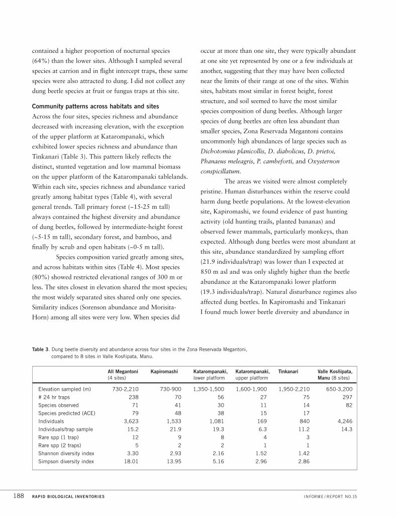
Table 3. Dung beetle diversity and abundance across four sites in the Zona Reservada Megantoni, compared to 8 sites in Valle Kosñipata, Manu.
All Megantoni Kapiromashi Katarompanaki, Katarompanaki, Tinkanari Valle Kosñipata,(4 sites) lower platform upper platform Manu (8 sites)
Elevation sampled (m) 730-2,210 730-900 1,350-1,500 1,600-1,900 1,950-2,210 650-3,200
# 24 hr traps 238 70 56 27 75 297
Species observed 71 41 30 11 14 82
Species predicted (ACE) 79 48 38 15 17
Individuals 3,623 1,533 1,081 169 840 4,246
Individuals/trap sample 15.2 21.9 19.3 6.3 11.2 14.3
Rare spp (1 trap) 12 9 8 4 3
Rare spp (2 traps) 5 2 2 1 1
Shannon diversity index 3.30 2.93 2.16 1.52 1.42
Simpson diversity index 18.01 13.95 5.16 2.96 2.86
RAPID BIOLOGICAL INVENTORIES INFORME / REPORT NO.15188
contained a higher proportion of nocturnal species
(64%) than the lower sites. Although I sampled several
species at carrion and in flight intercept traps, these same
species were also attracted to dung. I did not collect any
dung beetle species at fruit or fungus traps at this site.
Community patterns across habitats and sites
Across the four sites, species richness and abundance
decreased with increasing elevation, with the exception
of the upper platform at Katarompanaki, which
exhibited lower species richness and abundance than
Tinkanari (Table 3). This pattern likely reflects the
distinct, stunted vegetation and low mammal biomass
on the upper platform of the Katarompanaki tablelands.
Within each site, species richness and abundance varied
greatly among habitat types (Table 4), with several
general trends. Tall primary forest (~15-25 m tall)
always contained the highest diversity and abundance
of dung beetles, followed by intermediate-height forest
(~5-15 m tall), secondary forest, and bamboo, and
finally by scrub and open habitats (~0-5 m tall).
Species composition varied greatly among sites,
and across habitats within sites (Table 4). Most species
(80%) showed restricted elevational ranges of 300 m or
less. The sites closest in elevation shared the most species;
the most widely separated sites shared only one species.
Similarity indices (Sorenson abundance and Morisita-
Horn) among all sites were very low. When species did
occur at more than one site, they were typically abundant
at one site yet represented by one or a few individuals at
another, suggesting that they may have been collected
near the limits of their range at one of the sites. Within
sites, habitats most similar in forest height, forest
structure, and soil seemed to have the most similar
species composition of dung beetles. Although larger
species of dung beetles are often less abundant than
smaller species, Zona Reservada Megantoni contains
uncommonly high abundances of large species such as
Dichotomius planicollis, D. diabolicus, D. prietoi,
Phanaeus meleagris, P. cambeforti, and Oxysternon
conspicillatum.
The areas we visited were almost completely
pristine. Human disturbances within the reserve could
harm dung beetle populations. At the lowest-elevation
site, Kapiromashi, we found evidence of past hunting
activity (old hunting trails, planted bananas) and
observed fewer mammals, particularly monkeys, than
expected. Although dung beetles were most abundant at
this site, abundance standardized by sampling effort
(21.9 individuals/trap) was lower than I expected at
850 m asl and was only slightly higher than the beetle
abundance at the Katarompanaki lower platform
(19.3 individuals/trap). Natural disturbance regimes also
affected dung beetles. In Kapiromashi and Tinkanari
I found much lower beetle diversity and abundance in

PERÚ: MEGANTONI DICIEMBRE/DECEMBER 2004 189
secondary forest than in primary forest (Table 4).
Areas colonized by bamboo had much lower beetle
diversity and abundance than primary forest.
Resource partitioning
In response to competition within a large species
assemblage, dung beetles partition resources in several
ways. Species range from generalists to specialists and
partition resources by food type, diel activity, and
habitat selection, among other ways. I found that 24%
of all the beetle species in the reserve were generalists
attracted to another type of food in addition to dung
(Table 5). These other foods included fungus, fruit, and
carrion. Ten percent of all species collected were never
attracted to dung, suggesting that they specialize
exclusively on other food resources. No Neotropical
dung beetle species are known to specialize only on
particular types of dung (Howden and Nealis 1975;
Larsen, unpubl. data).
Species were fairly evenly split between diurnal
and nocturnal species (45% and 41% respectively). The
remaining 14% of species had crepuscular habits. Despite
my sampling across several habitats at each site, 32% of
Site 1 Site 2 S Obs 1 S Obs 2 Shared S Sorenson M-H
All sites Megantoni All sites Manu 71 82 49 0.43 0.47
Kapiromashi Katarompanaki 41 33 11 0.15 0.11
Kapiromashi Tinkanari 41 14 1 0.00 0.00
Katarompanaki Tinkanari 33 14 6 0.06 0.02
KAT Tall mixed forest Short Clusia forest 26 10 8 0.07 0.19
TIN Tall mixed forest Open shrubs 13 3 2 0.01 0.06
KAP Primary forest Secondary forest 34 20 20 0.33 0.59
TIN Primary forest Secondary forest 13 8 8 0.15 0.87
KAP Primary forest Guadua bamboo 34 23 21 0.14 0.60
TIN Primary forest Chusquea bamboo 13 5 5 0.38 0.95
S Obs 1 # species observed in Site 1
S Obs 2 # species observed in Site 2
Shared S # species shared
Sorenson Sorenson-abundance index
M-H Morisita-Horn community similarity index
KAP Kapiromashi
KAT Katarompanaki
TIN Tinkanari
Table 4. Similarity comparisons in dung beetle composition across sites and habitats in the Zona Reservada
Megantoni and Parque Nacional Manu.
Site # Species >dung no dung day night crep >1 hab 1 hab
All 71 24% 10% 45% 41% 14% 68% 32%
Kapiromashi 41 24% 12% 51% 29% 20% 61% 39%
Katarompanaki 33 18% 12% 36% 52% 12% – –
Tinkanari 14 14% 0% 29% 64% 7% 71% 29%
>dung: species attracted to dung and other food type
no dung: species never attracted to dung
day: diurnal species
night: nocturnal species
crep: crepuscular species
>1 hab: species found in more than 1 habitat type
1 hab: species only found in 1 habitat type
Table 5. Resource partitioning among dung beetles at three sites in the Zona Reservada Megantoni.

RAPID BIOLOGICAL INVENTORIES INFORME / REPORT NO.15190
all species were restricted to a single habitat type. The
amount of overall resource partitioning decreased with
increasing elevation (Table 5). At higher elevations, more
species responded solely to dung baits, and fewer species
are never attracted to dung. In these higher elevations
nocturnal species dominated the community, and species
moved more freely among habitat types. This decrease in
resource partitioning corresponded with a decrease in
dung beetle diversity and abundance.
Congener segregation
Across inventory sites in Megantoni, I observed
elevational segregation of species in the genus Ontherus.
This genus probably experienced a species radiation in
the Andes and is one of the few dung beetle genera that
are more diverse and abundant in the mountains than in
the nearby lowlands. Since the species collected in
Megantoni showed a similar distributional pattern to
those collected in Manu, I combined the data collected
from the two regions. Each species of Ontherus is
replaced by another species at increasing elevation
(Fig. 15). The Ontherus species distributions do not
seem to correspond to ecotones between vegetational
zones; the underlying factors determining their
distributions remain unknown. However, since the
congeners are so similar in size, morphology, diel
activity, and diet, interspecific competition is likely
to be intense and may prevent sympatric coexistence.
DISCUSSION
Zona Reservada Megantoni spans a broad range of
elevations and habitat types and contains an unusually
high diversity of dung beetles. Dung beetle diversity
decreases with increasing elevation, and encountering
71 dung beetle species between 730 and 2,210 m asl is
exceptional. Many of the beetle species in Megantoni
have restricted ranges (80% of species have altitudinal
ranges narrower than 300 m). Many species are
habitat specialists and ~10-35 are probably species
new to science.
Comparison with Valle Kosñipata,
Parque Nacional del Manu
In November 1999, I collected 82 species of dung
beetles in Valle Kosñipata, in the buffer zone of Parque
Nacional Manu. This site lies less than 100 km to the
south of Zona Reservada Megantoni and encompasses a
similar elevational range (see Figure 1). Pending direct
comparison of specimens, I estimate that 31% of the
beetle species I collected during the rapid inventory are
unique to Megantoni and not found in Manu. In Manu
I encountered more species, but I also sampled at twice
as many sites (8) and within a broader elevational range
(650-3,200 m) (Table 3). In direct comparisons of
elevational diversity between Manu and Megantoni,
several trends emerge (Fig. 16). The lowest inventory
Figure 15. Congener segregation by elevation in the genus Ontherus for combined sites from the Zona ReservadaMegantoni and Parque Nacional Manu.
. . . . . . . . . . . . . . .. .
. .. .
. .. .
. .. .
. .. .
. .. .
. .. .
. . . . . . . . . . . . . . . . . . . . . . . . . . . . . . .
..
..
..
..
.
..
..
..
.
RelativeAbundance
500 1000 1500 2000 2500 3000
Elevation (m)
1.0
0.8
0.6
0.4
0.2
10.0
O. azteca
O. pubens
O.alexis
O. obliquus
O.howdeni
O. sp nov nr bridgesi
. . . . . . . . . . . . . . . .
. . . .

PERÚ: MEGANTONI DICIEMBRE/DECEMBER 2004 191
site, Kapiromashi, and the upper platform of the middle-
elevation site, Katarompanaki, display levels of species
richness similar to levels expected at corresponding
elevations in Manu. In contrast, the lower platform
of Katarompanaki, which contains tall, mature forest,
and the higher elevation site, Tinkanari, both exhibit
considerably higher dung beetle diversity than would
be expected at equivalent elevations in Manu. Beetle
abundance per trap was nearly equivalent between
Manu and Megantoni.
Patterns of diversity and resource partitioning
Dung beetle diversity and abundance were highest in the
tallest mature forest and at lower elevations. This pattern
might reflect decreased resource availability associated
with lower mammal biomass at higher elevations and in
shorter and more open forest. The high abundance of
large dung beetles in Megantoni is a strong indication
that the habitats are intact and contain many large
mammals, since large beetle species are often the most
sensitive to disturbance and require plentiful dung. These
large beetle species are the most functionally important
for burying dung and dispersing seeds.
The ways in which dung beetles partitioned
resources according to food type, habitat, and diel
activity may help explain how such a large number of
species can coexist while competing for similar
resources. With a natural reduction in species diversity
at higher-elevation sites, I also observed less resource
partitioning. Debate is still intense over the mechanisms
that enable species coexistence, particularly in the highly
diverse tropical lowlands. My results suggest that a high
degree of resource partitioning in response to
competitive interactions could play a strong role in
facilitating species coexistence in species-rich sites. The
pattern of Ontherus congener segregation with elevation
provides additional evidence that competition could
structure dung beetle communities and determine
species distributions.
THREATS, OPPORTUNITIES,
AND RECOMMENDATIONS
Very few pristine areas of forest connect puna with
lowlands. Aside from containing many endemic species,
such corridors are essential for animal movement,
especially in response to climate change and global
warming. Species with narrow elevational ranges,
including many of the dung beetles in Megantoni, may
be the most sensitive to global warming and to local
changes in climate associated with deforestation.
Hunting pressures would almost certainly
decrease beetle abundance and could lead to local
species extinctions. In turn, local extinctions of many
dung beetles would disrupt the functions performed by
beetles, such as seed dispersal and parasite control,
which affect other animals and plants in the ecosystem.
Protecting dung beetles, particularly the larger species
so abundant in Megantoni, will safeguard some of the
functional interactions among species that maintain
ecosystem integrity.
The best way to conserve dung beetles and
their functional roles in the ecosystem is to maintain
large areas of intact habitats and to minimize the
impacts of hunting. Studying the elevational and
latitudinal distributions of dung beetle species in these
Figure 16. Comparison of elevational pattern of dung beetle species richness in the Zona Reservada Megantoniand Parque Nacional Manu.
Numberof Species
500 1000 1500 2000 2500 3000 3500
Elevation (m)
Parque Nacional Manu
Zona Reservada Megantoni
60
50
40
30
20
10
10

Andean montane and premontane areas could contribute
to understanding how species will respond to climate
change and deforestation, as well as to mitigating species
extinctions in one of the most species-rich and
biologically important regions in the world.
FISHES
Authors /Participants : Max H. Hidalgo and Roberto Quispe
Conservation targets : Fish communities in streams and other
aquatic habitats that drain the intact forests between 700 and
2,200 m asl; endemic Andean species such as Astroblepus
(Figures 8B, 8D), Trichomycterus (Figures 8E, 8F), Chaetostoma
(Figure 8A); species highly specialized on fast-flowing waters and
restricted to elevations above 1,000 m; pristine aquatic habitats
in the Peruvian Andes that support healthy populations of native
species; headwater streams of the Río Ticumpinía and Río Timpía
(Figure 3K), which harbor a unique icthyofauna
INTRODUCTION
The drainage network of Zona Reservada Megantoni
(ZRM) forms part of the watershed of the lower
Río Bajo Urubamba (Cusco Department). In the past six
years several studies have documented the biodiversity
and the conservation status of the fish communities of
this region, especially in areas near the Amazonian basin
(Ortega et al. 2001). To date, few studies have surveyed
fish in tributaries of the lower Urubamba above 700 m
elevation, mainly because the rugged terrain and steep
slopes are difficult to reach and streams in the area are
not navigable.
Our primary goal was to inventory the
icthyofauna in the suite of aquatic habitats found in
ZRM, with an emphasis on streams above 700 m
elevation in the eastern region. Many rivers and streams
that originate on highland slopes (~4,000 m) drain the
ZRM and provide habitats for species uniquely adapted
to aquatic Andean environments. Compared to other
Andean sites, fish communities in the ZRM have
remained isolated from human influence. Our inventory
provided a unique opportunity to document an unknown
icthyofauna in an area of high conservation value.
METHODS
Collection and analysis of biological material
We collected fishes using several different netting
methods, including a 7 x 1.8-m net with a 5-mm mesh,
a 3 x 1.2-m net with a 2-mm mesh, an 8-kg cast net, a
dip net, and a small aquarium net. We seined areas near
riverbanks and in the main channel with the large nets.
Nets also functioned as fish traps when placed at the
base of rapids; we removed rocks from these rapids and
chased fish towards the nets. We used the cast net to
take repeated, more quantitative samples of fish. At
each sampling station, we repeated the various fishing
methods until we obtained a representative sample.
Local guides accompanied and assisted us at each site.
We preserved all specimens in a 10% formalin
solution for 24 hours and transferred them to 70%
alcohol for long-term preservation. The specimens were
labeled, prepared, and packed for transport to Lima.
The majority of fishes were identified in the field.
For species that we suspected could be new to science, we
took photographs to send to specialists. For the purposes
of the rapid inventory, we classified unidentifiable species
as morphospecies, as in previous inventories in Yavarí and
in Ampiyacu, Apayacu, Yaguas, and Medio Putumayo
(Ortega et. al 2003, Hidalgo and Olivera 2004). All
specimens were deposited at the Museo de Historia
Natural-UNMSM in Lima and are now part of the
museum’s Icthyological Collection.
Selection of sampling stations
We took GPS coordinates at each sampling station,
and we referenced points to the base camp, recording
the physical characteristics of each station (Appendix 3).
Sampling efforts were variable and were greater in the
larger aquatic environments. We constructed trails to
survey a variety of aquatic habitats, and at the first site
we followed the course of the Río Ticumpinía to
inventory areas upstream and downstream from the
base camp. We never used boats in this inventory.
In Kapiromashi, we sampled fishes in the
Río Ticumpinía and in tributary streams. We conducted
river sampling primarily in areas with sandy beaches,
RAPID BIOLOGICAL INVENTORIES INFORME / REPORT NO.15192

PERÚ: MEGANTONI DICIEMBRE/DECEMBER 2004 193
rapids, and braided channels around river islands. We also
sampled tributary streams along transects extending ~200
m upstream from their confluence with the main river.
In Katarompanaki and Tinkanari, we
established trails along the river course and tried to
sample upstream and downstream areas equally.
We sampled all streams accessible by trail. Only in
Tinkanari did we sample a lentic environment, a small
blackwater pond.
Description of sites and aquatic environments
We sampled aquatic habitats in Kapiromashi
(four days), Katarompanaki (five days), and Tinkanari
(five days), surveying 23 sites, 8 at the first and third
campsites and 7 at the second campsite (Appendix 3).
These sites corresponded to 17 streams and 6 sites along
the Río Ticumpinía. In Kapiromashi, all collection sites
were whitewater rivers, in Katarompanaki all were
blackwater rivers (or blackwater mixed with
whitewater), and at the third site we sampled mainly
whitewater rivers. At the first site, we were able to
sample all the aquatic habitats that we identified in the
Kapiromashi area. At the second site, we were unable to
sample either the rivers that feed the Ticumpinía or the
area where smaller streams enter the main tributaries
below the tablelands. At the third site, we were unable
to reach the Río Timpía or the large blackwater lakes
that we saw from the helicopter.
Kapiromashi (~750-900 m asl)
This site was in the Río Ticumpinía valley (Figure 3C).
We sampled streams draining areas between 750 and
900 m elevation. The Río Ticumpinía harbors the
largest number of fish species and sustains the largest
fish biomass when compared to the smaller streams in
the area. The river is an eastern tributary of the lower
Urubamba, and their confluence lies ~6 km north of the
Pongo de Maenique (see Figure 2).
The Río Ticumpinía is a medium-sized,
whitewater river that turns green during the dry season.
Its highly sinuous channel is 30-50 m wide, dotted with
islands of variable size (1 km long near base camp,
Figure 3C). Bed sediments contain small and medium-
sized rocks, with sandy beaches in the bends of the river
and muddy areas where the rocky islands connect with
the main channel. During the rapid inventory the
average river depth was 80 cm, with a maximum depth
of 1.5 m. The river changed ~150 m in elevation over
~5 km. Large sandy beaches lined the riverbanks in
several areas; in others, vertical, vegetation-covered
walls defined the channel.
The Ticumpinía contains many rapids that can
generate differences as great as 3 m in water level over
distances of ~50 m, and can create a strong current.
Because of this current, we were unable to sample the
area where the Ticumpinía forms, near the confluence
of the Shakariveni to the south and an unnamed river
to the north, despite its short distance from base camp
(~5 km). We did sample the shallow, slow-moving water
in the narrow channels around river islands. Streams
feeding the Río Ticumpinía were generally small (up to
4 m wide) and characterized by completely transparent
water and a mixture of cobble, gravel, and sand in
the streambed.
Katarompanaki (~1,360-1,700 m asl)
Our campsite was situated on a tableland between the
rivers that form the Ticumpinía, at 1,769 m. We
sampled all aquatic habitats that we could reach by trail
between 1,360-1,700 m asl, traveling between two
platforms on the tablelands. Streams in this area
apparently drain toward a northern confluent of the Río
Ticumpinía and the majority lay on the higher platform
(1,700 m asl). Only one stream drained the forest on the
lower platform (1,360 m asl).
The aquatic habitats of the platforms
differed in their geomorphology and riparian vegetation.
Vegetation on the high platform was dominated by
arboreal Clusia spp. (Clusiaceae), whereas the lower
platform contained more diverse vegetation, with taller
trees, a closed canopy, and many fruiting species (see
Flora and Vegetation). The streams of the upper platform
were generally small (up to 4 m wide and 1.2 m deep),
with turbulent blackwater, cobbles and moss-covered
boulders, and steep slopes (~ 30°). These characteristics

distinguished streams at this site from those at
Kapiromashi and Tinkanari.
The stream draining the lower platform
(1,360 m) was the largest sampled near this camp
(up to 13 m wide) and was distinct from all other
streams surveyed in the inventory. Slippery bedrock
covered the entire width of the channel for at least 500
m and we found several pools up to 1.5 m deep. After
500 m, the bed sediment changed and boulders created
small waterfalls, similar to those in the tributaries of
the Tinkanari.
Tinkanari (~2,100-2,200 m asl)
This site was situated near the headwaters of the
Río Timpía, in the mountain range that forms the
eastern border of ZRM. We sampled all aquatic habitats
accessible by trails between ~2,100 and 2,200 m asl.
Some streams drain directly into the Río Timpía;
others drain into larger streams that later flow into
the Río Timpía.
Tree ferns and tall canopy trees dominated the
riparian vegetation. Slopes of rivers were variable, with
gentle slopes in small streams, and steep slopes and
waterfalls (~1-6 m in height) in the larger streams. Nearly
all streams were whitewater, varying in width (2-13 m)
and containing a heterogeneous mix of cobbles, boulders,
and fine gravel. Along a 1-km transect in the largest
stream, we observed some deep pools up to 2 m deep,
usually below waterfalls.
During the helicopter flight to this camp, we
noticed several large blackwater lagoons (~100 m
diameter) near the Río Timpía. Close to the campsite we
found a small blackwater pond; however, we suspect the
biota of this pond differs from the much larger lagoons.
This pond measured 25 m across and 1.8 m deep and
had a large mat of algae and a muddy bottom. Grasses
and orchids grew around its edges. The pond likely
occurs close to the water table. Despite intense effort,
we did not collect a single fish in the pond and did not
include this sample in the data analysis. We suspect the
larger lagoons do contain fishes, given their proximity
to the Río Timpía.
RESULTS
Species diversity and community structure
The 3,132 individual fishes registered during the
inventory include 22 species, 13 genera, 7 families, and
2 orders (Appendix 4). Of these 22 species, only 8 have
been identified to species (36%) and at least 10 require
more detailed study (in Astroblepidae, Trichomycteridae,
Cetopsis and Chaetostoma) for identification.
For several species we will need to consult
monographs, museum specimens, and specialists.
We cannot confirm identifications for any species of
Astroblepidae or Trichomycteridae, as few studies of
these groups exist. Several probably represent species
new to science, e.g., Astroblepus sp. C (S. Schaefer, pers.
comm., Figure 8D). Peruvian species of Chaetostoma
(carachamas) currently are being revised, and we expect
to find species new to science in this group as well, such
as Chaetostoma sp. B (N. Salcedo, pers. comm., Figure
8A). Cetopsis sp. is an undescribed species known from
the lower Urubamba (R. Vari, pers. comm., Figure 8G).
Fish communities in ZRM consist exclusively
of fishes in the orders Characiformes and Siluriformes.
Some of the Characiformes species are also found in
lowland forest streams and widely distributed in
Amazonia (Astyanax bimaculatus, Hoplias malabaricus).
We also recorded species restricted to south-central Peru,
especially to streams above 300 m asl in the Urubamaba,
Pachitea, and Perené drainages (Creagrutus changae,
Ceratobranchia obtusirostris), or to streams draining
the foothills of the transition zone between lowland and
upland forest (Bryconamericus bolivianus, Hemibrycon
jelskii). Among the Siluriformes, the majority of the
species are catfish and lack scales. One of these is
Rhamdia quelen, a species with broad distribution in the
Peruvian Amazon. Some species in the Trichomycteridae
are probably restricted to the Andes in central and
southern Peru, and at least one species (Trichomycterus
sp.1) also occurs in the lowland areas of the Urubamba
and Manu, as well as around Tambopata.
With the exception of Hoplias malabaricus
(huasaco) and Rhamdia quelen (cunchi), adult fishes are
RAPID BIOLOGICAL INVENTORIES INFORME / REPORT NO.15194

PERÚ: MEGANTONI DICIEMBRE/DECEMBER 2004 195
small, measuring less than 15 cm, and in the
Characidae, less than 10 cm. We collected some
Astroblepus sp. B that are 15 cm in length, a size rarely
observed in scientific collections (Figure 8H). The other
3 species of Astroblepus we found were more typical
sizes, with the largest individuals measuring ~7 cm.
About 10 of the species are fished locally for
subsistence by the indigenous communities near the
Zona Reservada (Appendix 4), principally Timpía and
Sababantiari. With the exception of Astroblepus sp. B
(Figure 8H), all of the species fished for food we found
were in the Río Ticumpinía and surrounding streams.
Diversity by site
Kapiromashi
With 17 species (9 of Siluriformes and 8 of
Characiformes), this site supported the highest species
richness of the three inventory sites. All families registered
in the inventory were present here (Appendix 4), and fish
abundance in streams near this camp was the highest of
any site in the inventory (85% of total individuals). In the
Characiformes alone, 80% of the individuals registered
during the inventory were recorded at Kapiromashi.
None of the species registered here was present in
streams at the other inventory sites.
We collected only one or two individuals of
some species (Appendix 4). Other genera, such as
Ceratobranchia, Astyanax, and Hemibrycon, were more
abundant and common in several habitats. Although
less abundant than the Characidae, Chaetostoma was
common and occurred at densities similar to those
observed in the upper part of the Río Camisea (300 to
450 m asl; Hidalgo 2003). Chaetostoma was more
abundant in rivers than in streams; it may be a food for
various species of aquatic birds and for river otters.
Overall, sampling species of carachamas was difficult as
they inhabit turbulent waters, and their abundances
may be greater than our estimates.
Fishes in Kapiromashi represent various
functional feeding groups. The majority of the
omnivorous species are Characidae (Astyanax,
Bryconamericus, Ceratobranchia, Hemibrycon, Knodus,
Creagrutus) and Trichomycteridae. All of the species of
Loricariidae are herbivores, feeding on algae by scraping
their teeth on rocks and submerged logs. Very little is
known about the feeding ecology of Astroblepus, but
probably they also eat algae growing on hard substrates
characteristic of the turbulent streams of the Andes,
or feed on the abundant aquatic insects that inhabit
these environments.
In aquatic habitats where bed sediments are
composed of clay, we observed tunnels made by
carachamas, also observed previously in the Bajo
Urubamba. Ancistrus species use the tunnels to make
nests. Chaetostoma and Ancistrus lay sticky eggs on
boulders or inside submerged logs and guard their nests.
Among the predators, the largest (and one of
the few piscivores that we registered in the inventory)
was Hoplias malabaricus (huasaco), which can measure
up to 50 cm in length. This species generally prefers
areas of less current where it sits and waits for its prey.
Other predators, like larger individuals of Rhamdia
quelen, are nocturnal predators that actively search for
their food. Cetopsis (Figure 8G) likely prefers aquatic
insects or small fishes, both of which are abundant in
the Río Ticumpinía.
Katarompanaki
At this site we collected three fish species, two
Trichomycterus (Figures 8E, 8F) and one Astroblepus
(Figures 8B, 8H). Compared with Kapiromashi,
Katarompanaki had very few species, but all were
different. The fish community composition at the second
site might reflect the isolation of its aquatic habitats
from main river channels or physical characteristics of
the higher-elevation streams.
Fish sampling was difficult at this site.
Compared with species found in streams near the first
campsite, species collected at this site were cryptically
colored, blending in with the bed sediments where they
live and eat (Trichomycterus) or attaching themselves to
the substrate (Astoblepus), where they are almost
impossible to observe.
In the streams of the upper platform (~1,700 m),
we registered only Trichomycterus sp. C (Figures 8C,
8E), a species present at low abundances in almost all

streams sampled. In the large stream of the lower
platform (~1,360 m), we registered Trichomycterus sp.
D (Figure 8F) and Astroblepus sp. B (Figures 8B, 8H).
Of the three sites, this one had the lowest abundance of
individuals (4% of total) and species (13%).
Tinkanari
Here we registered five species of fishes, three
Astroblepus and two Trichomycterus. All of the species
found in streams near the Katarompanaki camp were
present here, but two Astroblepus species were unique
to Tinkanari. Fish abundance was higher here (11% of
total) than at Katarompanaki.
Streams at this site are whitewater and rocky,
with steep slopes, all potentially favourable conditions
for Astroblepus species. Species of Astroblepus inhabit
all streams here, and in two streams we found three
species living in sympatry. Species of Astroblepus have
a ventral mouth, pelvic and pectoral fins with hooks,
and an abdominal musculature unique among the
Siluriformes. These morphological adaptations allow
Astroblepus to climb and attach to steep, turbulent,
lotic environments, including cliff faces (Figure 3H),
with little difficulty. According to S. Schaefer (pers.
comm.), finding several species of this genus coexisting
within a stream is unusual.
Great variation in morphology exists within
the Astroblepidae, and we have only a rudimentary
understanding of their systematics. We cannot confirm
that the three species we observed are truly distinct from
each other. However, based on our preliminary
observations and consultations with specialists, the
probability that they are different taxa is high, and at
least one species is likely new to science.
Noteworthy records
Despite low overall species richness, we documented
substantial populations of fishes in streams within these
intact highland forests. Because of the geographic
isolation of the watersheds, many of these species are
likely endemic to the area (Vari 1998, Vari et al. 1998,
De Rham et al. 2001). In particular, species in the
families Astroblepidae and Trichomycteridae have
unique adaptations that allow them to live in the
turbulent waters of these highland streams. At least
three species we collected are new to science; these
include Cetopsis sp. (Figure 8G), Chaetostoma sp. B
(Figure 8A), and Astroblepus sp. C (Figure 8D) and,
pending further revisions, will likely include species of
Trichomycteridae as well.
DISCUSSION
Comparisons with adjacent areas
(Urubamba and Manu)
This study is the first inventory of fishes in ZRM.
We studied fish communities between elevations of 750
and 2,200 m asl, where diversity and abundance of fishes
are lower than in the Bajo Urubamba (202 species;
H. Ortega, pers. comm.) and the Río Manu (210 species;
Ortega 1996), the areas adjacent to ZRM. Both the
Bajo Urubamba and the Manu are large drainages,
flowing into the Amazonian lowlands and creating
multiple microhabitats with high species richness and
fish biomass.
In the Urubamba, only two inventories
surveyed streams above 500 m elevation. Eigenmann
and Allen (1942) reported 21 species in the Alto and
Medio Urubamba (~700 m), similar to the richness
encountered in ZRM (22 species). Species overlap
between ZRM and the Alto and Medio Urubamba is
high in the Characiformes and Siluriformes: the two
faunas differ only in the two species of electric fishes
registered in ZRM. These electric fishes are found in the
lower sections of the Bajo Urubamba, but not the Alto
or Medio Urubamba.
As part of the environmental impact assessment
(EIA) of the Camisea natural gas pipeline (Camisea EIA
2001), 33 species of fishes were reported in various
tributaries of the Alto Urubamba and the Río Apurímac
(610-1,250 m asl). Additional collections were made in
the Río Cumpirosiato (tributary of the Alto Urubamba).
Species composition in ZRM is similar to that of fish
communities sampled in the EIA; however, the total
abundance registered in our study was much greater
RAPID BIOLOGICAL INVENTORIES INFORME / REPORT NO.15196

PERÚ: MEGANTONI DICIEMBRE/DECEMBER 2004 197
(3,132 individuals in 23 sites vs. ~300 individuals in
12 sites). Both Camisea EIA (2001) and Eigenmann and
Allen (1942) surveyed aquatic environments along the
western slopes of the Urubamba along the Cordillera de
Vilcabamba, as well as the Río Apurímac valley. Neither
study evaluated fish communities along the eastern
slopes, where ZRM lies.
In Manu, Ortega (1996) collected fishes between
600 and 1,000 m asl in the Alto Madre de Dios (between
Salvación and Pilcopata), registering 25 species. Species
richness is similar to that of ZRM, but community
composition differs at the species level for several genera
(Creagrutus, Hemibrycon, Trichomycterus, and maybe
Astroblepus). In addition, other genera (Bario,
Hemigrammus, Gymnotus) characteristic of the Amazon
lowlands were absent in ZRM, and Bario has never been
recorded in the Bajo Urubamba.
In the Alto Madre de Dios, Ortega also
reported certain genera that we expected to find
inhabiting foothill streams of ZRM (up to ~1,000 m),
such as Parodon and Prodontocharax, which are both
represented in the Bajo Urubamba. Like the Urubamba,
the Alto Madre de Dios has electric fishes (Gymnotus),
the most diverse and frequently encountered genus in the
Amazon lowlands and floodplain. Additional inventories
would probably register these species in ZRM.
The differences in community composition
between ZRM and the Alto Madre de Dios may reflect
topographic differences in the two watersheds. In contrast
to Manu National Park (Madre de Dios), the rugged
topography of the Río Timpía and Río Ticumpinía, with
their many waterfalls, seems to have limited the dispersal
of species present in the lowlands (lower Urubamba) to
areas above 500 m.
Comparison with other areas in Peru
Species richness in ZRM is typical of highland regions,
and comparable to that of other higher-elevation
inventories. Ortega (1992) lists only 80 species above
1,000 m elevation in Peru, including all of the aquatic
habitats of the western and eastern Andean slopes. These
species account for less than 10% of the freshwater fish
diversity of Peru (Chang and Ortega 1995).
In the Río Perené watershed (600-900 m asl),
Salcedo (1998) reported 45 species. When this
watershed is compared to ZRM, similarities exist in
species composition of the Characiformes and generic
composition of the Siluriformes (except Cetopsis sp.
nov. in ZRM). In the Río Pauya watershed (Parque
Nacional Cordillera Azul), De Rham et al. (2001)
reported 21 species of fishes between 300 and 700 m
asl, in genera similar to those of fish communities in
ZRM. Nonetheless, several fishes in the Río Pauya
inhabit only the lower part of the watershed. For the
Cordillera del Condor, Ortega and Chang (1997)
reported 16 species inhabiting streams between 850 and
1,100 m, including a new species of Creagrutus.
In the Cordillera de Vilcabamba, Acosta et al.
(2001) concentrated their efforts on collecting aquatic
invertebrates and evaluating the limnology of streams
draining the slopes of the Apurímac valley (1,700-2,400
m asl). One Trichomycterus sp. and one Astroblepus sp.
were collected during this study. Although neither has
been identified to species, they may be different from
species found in ZRM. As in ZRM, abundance of these
two species was low.
In summary, the icthyofauna of ZRM contains
a surprising richness of fishes adapted to its turbulent
waters, abundant fish populations, and several new
species. Considering the areas still unstudied (see Results),
we estimate that ZRM contains close to 70 fish species.
Fish inventories in the Andes are scarce, and this
inventory fills an important gap in our knowledge of
Peru’s freshwater fishes.
THREATS, OPPORTUNITIES, AND
RECOMMENDATIONS
Opportunities for conservation and research
The natural icthyofauna in many aquatic environments
in the Peruvian Andes has been drastically reduced by
changes in water quality after habitat alteration
(e.g., deforestation, pollution), and often several exotic
species have successfully invaded the natural habitats.
In Lake Titicaca, the introduction of rainbow trout

(Oncorhynchus mykiss) and the Argentine pejerrey
(Odonthesthes bonariensis), combined with habitat
degradation, has resulted in the near extinction of
Orestias cuvieri, the largest species in a genus endemic
to the high Andes (~4,000 m) between Peru and
northern Chile. In the Alto Urubamba watershed,
trout are widespread in natural environments and are
cultivated throughout the watershed. This degradation
is absent in ZRM. Megantoni offers the unparalleled
opportunity to conserve aquatic habitats that are still
free of nonnative invasive species (see Figures 3H, 3K).
The protection of the headwaters of several rivers
and other intact aquatic habitats within ZRM is critical
for preserving the hydrologic cycle in these watersheds, as
well as the natural icthyofauna. The icthyofauna of ZRM
remains unknown in several areas: the lower part of
ZRM, from 500 to 700 m asl; the Río Yoyato drainage;
the upper Río Timpía; the aquatic habitats of the
mountains between the Río Ticumpinía and the Pongo de
Maenique; habitats between 900 and 1,500 m asl; the Río
Urubamba where it passes through the Pongo del
Maenique; the blackwater lagoons of the upper Río
Timpía; the ponds of the high-altitude grasslands (puna);
and the aquatic ecosystems inside ZRM west of the
Pongo, including part of the Río Saringabeni.
Opportunity is great for studies of the ecology,
evolution, and biogeography of restricted or endemic
species in the highland habitats of these mountains.
Studies of beta diversity in this area are of special
research interest, especially since we observed very little
overlap between species at the three inventory sites.
We also expect that future studies may shed light on the
potential for isolation and vicariance to promote
speciation in fishes, especially Astroblepus and
Trichomycterus.
Threats and recommendations
Colonization of ZRM could threaten the quality of
aquatic ecosystems. For the most isolated areas of ZRM,
such as the headwaters of the Timpía (Figure 3K) and
Ticumpinía, and some of the high-altitude grasslands,
colonization is a minor threat. However, if local
authorities continue to promote land colonization
in the area, perhaps even these seemingly inaccessible
territories may become threatened.
The extraction of hydrocarbons is perhaps the
largest threat to ZRM, as the Camisea gas operation lies
just ~40 km north of the Zona Reservada. The next few
years may see increased exploration for gas deposits
along the lower Urubamba. Additional gas exploration
risks polluting the lower Urubamba and altering
migration patterns of fishes reproducing closer to the
headwaters (up to ~500 m asl), affecting local fish
distributions and possibly reducing game fish species.
Surveillance of fish communities, in addition to
monitoring resource use by local fishermen, will be
critical to understanding how to protect the lower
Urubamba drainage.
An additional threat for the icthyofauna of
ZRM is the constant use of natural toxins (known
locally as barbasco or huaca) for fishing (Figure12A).
For several ethnic groups that inhabit the lower
Urubamba, this is a traditional fishing method, along
with arrows, harpoons, and nets. Casual observations
suggest these natural toxins harm fish communities and
other aquatic biota, but few scientific studies in Peru
quantify this damage, especially at a population level
evaluating cumulative effects. We recommend
investigating the effects of fishing toxins on aquatic
communities, and complementing these studies with
workshops or environmental education programs or
both, to reduce toxin use in local communities.
We suggest an integrated management plan
for the watersheds of ZRM, from the headwaters of the
Timpía to the Ticumpinía and other aquatic ecosystems.
ZRM is a refuge for native fishes that are rapidly
disappearing from other parts of the Peruvian Andes.
A refuge in this region will conserve ecosystems that are
threatened by colonization and development in other
areas of Peru.
RAPID BIOLOGICAL INVENTORIES INFORME / REPORT NO.15198

PERÚ: MEGANTONI DICIEMBRE/DECEMBER 2004 199
AMPHIBIANS AND REPTILES
Participants /Authors : Lily O. Rodríguez and Alessandro Catenazzi
Conservation targets : Communities of anurans, lizards, and
snakes typical of middle-elevation slopes in southeastern Peru
(1,000-2,400 m asl); amphibian communities in streams;
populations of rare species and species with restricted distribu-
tions, including Atelopus erythropus and Oxyrhopus marcapatae
(Figure 9B); new amphibian species including an Osteocephalus
(650-1,300 m asl, Figure 9E) and a Phrynopus (1,800-2,600 m
asl) also known from the Kosñipata valley, at least one new
species of Eleutherodactylus (1,350-2,300 m asl), a Centrolene
(1,700 m asl, Figure 9H), a Colostethus (2,200 m asl), one
possibly new species of Gastrotheca (2,200 m asl, Figure 9F),
and a Syncope (1,700m) that is the most southerly record of this
genus in Peru; a new species of snake (Taeniophallus, 2,300 m;
Figure 9D); new species of lizards, including a Euspondylus
(1,900 m asl, Figure 9A) also present in Vilcabamba, and three
other unidentified lizards (Proctoporus, Alopoglossus [Figure 9C],
and Neusticurus) living on the isolated tablelands in Megantoni;
lower elevation (< ~700 m) populations of yellow-footed tortoises
(Geochelone denticulata) hunted for food
INTRODUCTION
Sampling of the herpetofauna in the Urubamba valley
was not systematic before this inventory. Scattered
reports exist of amphibian and reptile species that occur
between Kiteni and Machu Picchu (Henle and Ehrl
1991, Reeder 1996, Köhler 2003). In 1997, amphibian
and reptile communities were sampled as part of the
environmental assessment for natural gas explorations
in Camisea (Icochea et al. 2001). More extensive
inventories were conducted in the Kosñipata valley in
the higher elevations of Parque Nacional (PN) Manu
(Catenazzi and Rodríguez 2001). A rapid inventory in
the Cordillera Vilcabamba sampled areas at 2,100 and
3,400 m asl in PN Otishi and along the slopes of the
Río Tambo and Río Ene, and in Reserva Comunal
Machiguenga (~ 1,000m) in the Urubamba valley
(Rodríguez 2001). In 1999 an expedition on the
outskirts of Comunidad Nativa Matoriato, ~5 km north
of Zona Reservada Megantoni (ZRM), found several
common lowland species of amphibians and reptiles
(CEDIA 1999).
Nevertheless, the amphibians and reptiles of
ZRM were virtually unknown before the rapid
inventory. Judging from our data from similar elevations
in the Kosñipata valley (Catenazzi and Rodríguez
2001), we expected to encounter 50 to 60 species of
amphibians in the range sampled during this rapid
biological inventory. We found 51 species (Appendix 5).
Here we report our results from three inventory
sites (650-2,350 m asl) within Megantoni, and compare
our observations with the herpetofauna known from
other sites on the eastern slopes of the Peruvian Andes.
In particular, we highlight groups characteristic of
similar elevations in nearby regions and compare
amphibian and reptile communities between ZRM and
other protected areas in the National System of
Protected Areas in Peru (SINANPE), such as PN Manu
and the Vilcabamba conservation complex (PN Otishi,
RC Machiguenga, RC Ashaninka).
METHODS
We recorded anurans, snakes, and lizards at every site.
We focused our sampling efforts on anurans, which
have greater abundances than snakes and lizards, and
better-known distributions.
We sampled during the day and at night, using
a mix of visual and auditory surveys. From surveys of
frog calls we determined relative abundance of species
in different habitats. We focused on streams and humid
areas and conducted several intensive surveys of leaf
litter. During the inventory, the icthyological team
collected several tadpoles.
We photographed, identified, and released
species we could positively identify. For potentially new
species or species that are difficult to identify in the
field, we fixed specimens in 10% formaldehyde solution,
preserved them in alcohol, and deposited them at the
Museo de Historia Natural of the UNMSM in Lima.
We recorded calls of several species for comparison with
recordings from the Kosñipata valley, or to write the
first scientific descriptions of their calls.
We sampled for 170 hours over 19 days in
three inventory sites. Our sampling effort differed

among sites. At Kapiromashi, we sampled mostly at
night for 4-6 hours until 11 P.M. At the two higher-
elevation sites, we sampled most extensively during the
day and visited trails and stream edges from 6 until 10
P.M. In the Katarompanaki tablelands, we spent ~65%
of our time on the upper tier (~1,700 m asl) and ~35%
on the lower tier (~1,350 m asl). Other members of the
inventory team, particularly Guillermo Knell and Daniel
Rivera, contributed observations and captured animals.
We surveyed a variety of habitats.
At Kapiromashi, we sampled along the beaches and
channels of the Río Ticumpinía, seasonal streams,
low-elevation streams, alluvial forests, and bamboo-
dominated forest (pacales, Figure 3E). Here we also
sampled several microhabitats including vegetation
along trails and streams up to 2 m in height, palm leaf
litter, water-filled internodes of bamboo stems, tree
buttresses, light gaps, and pools in streams.
At Katarompanaki and Tinkanari, we sampled
hillside forests, fast-moving streams (including two in
Katarompanaki with sandstone substrates), streams on
the upper platform of the tablelands, waterfalls, pools,
and stunted forests. We sampled most intensively leaf
litter, vegetation along trails and streams, moss,
epiphytic bromeliads, tree buttresses, and arboreal ferns.
During the helicopter ride between Katarompanaki and
Tinkanari, we saw several blackwater lagoons (~1,500-
2,000 m asl) but were unable to sample these.
RESULTS
We encountered 51 species of amphibians and reptiles:
32 amphibians, 9 lizards, and 10 snakes. Slightly more
than 20% are species new to science: 7 anurans, 4 lizards,
and 1 snake (See Appendix 5). Our inventory increased
the known geographic and elevational distributions of
several species and even a few genera. Megantoni is the
southernmost distributional record in Peru for Syncope,
including an undescribed species, and the lowest elevation
recorded for Phrynopus and Telmatobius.
One-fifth of the herpetofauna in ZR Megantoni
is new to science. This landscape also harbors several
endemic reptiles. Moreover, the herpetofauna
complements the diversity found in PN Manu and
RC Machiguenga in the Vilcabamba mountains, with
only minimal overlap between these areas.
Kapiromashi
At this low-elevation site (650-1,200 m asl), we
registered 13 amphibians, 3 lizards, and 2 snakes.
We encountered mostly species typical of the lowlands
but found here at the upper elevational limits of their
distributions. Notably, we found Epipedobates macero
(Figure 9G), a rare poison dart frog restricted to the
Purús in Brazil, PN Manu, and the basin of the
Río Urubamba. This record extends the elevational range
of E. macero to 800 m from the previous record of
350 m, where the species was described in Manu. We
also registered an undescribed species of Osteocephalus
(Figure 9E), a rare arboreal frog also encountered
between 650 and 1,300 m asl in the Kosñipata valley.
The Osteocephalus was the only species recorded
at this site and unknown from the lowlands.
Eleutherodactylus danae also occurs in the Kosñipata
valley, and our record of a juvenile here extends its
distribution westward toward the Urubamba valley,
and to lower elevations than previously recorded.
Overall, we did not encounter many species of
anurans, most likely because our inventory occurred
after the breeding season. At these latitudes in Peru,
anuran mating seasons generally end in April, and
afterward adults are quiet and difficult to find. Despite
searching extensively in the abundant bamboo stands,
we did not encounter Dendrobates biolat, a species
typical of these habitats in PN Manu. If it does occur,
its density may be very low.
Snakes were rare at this site, especially on the
beaches of the Río Ticumpinía, where we had expected
to find them sunning themselves. Lizards were similarly
scarce. We found only one Anolis in the forest (similar
to fuscoauratus but probably another species), and
Ameiva ameiva and Kentropyx altamazonica near the
river beaches. In the bamboo forests on the forested
slopes (~1,000 m) we encountered what might have
been Stenocercus roseiventris, but it escaped before we
could identify it decisively.
RAPID BIOLOGICAL INVENTORIES INFORME / REPORT NO.15200

PERÚ: MEGANTONI DICIEMBRE/DECEMBER 2004 201
Katarompanaki
From this site we surveyed two platforms differing in
elevation and habitat types. Solid rock underlies the
riverbeds on both platforms, but much taller forest
grows on the lower platform.
Upper platform
On the higher platform (1,760-2,000 m asl) we found
8 species of anurans, 3 lizards, and 3 snakes. Generally,
the habitat of the upper platform, a stunted nutrient-
poor forest, is not favorable for anurans, and the area’s
isolation and small size may prevent colonization of
many species. In the streams, we encountered 3 breeding
glass frog species (Centrolenidae); 2 are known from the
Kosñipata valley. One species, a Centrolene (Figure 9H),
is without a doubt new to science. We know of two
other undescribed species in this genus; one occurs
further north in PN Otishi and the other in the
Kosñipata valley.
The most abundant species at this site, an
Eleutherodactylus in the rhabdolaemus complex (within
the unistrigatus group), appears restricted to Megantoni
and has not been recorded in neighboring Manu or
Vilcabamba where other members of this complex occur.
In the short, moss-covered vegetation on the upper edge
of the platform we captured a Euspondylus lizard new to
science, but the animal escaped and we salvaged only the
tail. Although undescribed, this species has been reported
in similar habitats in Llactuhuaman in the Cordillera de
Vilcabamba, reaching 2,600 m asl (Icochea, pers.
comm.). We registered a potentially new species of
Proctoporus, different from P. guentheri reported from
similar elevations in Vilcabamba by Icochea et al.
(2001). We also registered an apparently undescribed
species of Neusticurus, recorded previously from Santa
Rosa (~800 m asl), in the Inambari basin, Puno
Department, ~230 km southeast of Megantoni
(L. Rodríguez, unpubl. data).
The most surprising record at this site
was a minute frog (14 mm), in the genus Syncope
(Microhylidae), found in moss on the forest floor.
Previously these tiny frogs were known only from
Cordillera del Sira (Pasco; Duellman and Toft 1979) and
Cordillera Azul (San Martín); the Megantoni record is
the southernmost for this genus in Peru. Moreover, the
Megantoni specimen might be new to science. We found
an Eleutherodactylus of the discoidalis group that may
also be new to science.
Lower platform
We spent only two nights collecting on the lower platform
(1,350 m asl). No species were actively reproducing in
the streams here, but we did register Bufo typhonius sp.2,
Eleutherodactylus mendax, and E. salaputium, as well as
Phyllonastes myrmecoides. Snakes were abundant here,
especially Clelia clelia.
Tinkanari
Our third inventory site covers elevations (1,800-2,600
m asl) that have been poorly surveyed in Manu. During
our rapid inventory of this high-elevation forest, we
found 10 species of anurans, 2 lizards, and 4 snakes.
One of the most notable records, Atelopus erythropus,
is known only from the holotype (Boulenger 1903,
Lötters et al. 2002) and populations in the Kosñipata
valley (Rodríguez and Catenazzi, unpubl. data). The
Megantoni population of A. erythropus is apparently
unaffected by the chytrid fungus that is severely
reducing populations of several species of the same
genus in Central and South America.
The largest of all frogs found at this site was
an arboreal marsupial frog, Gastrotheca sp. (Figure 9F),
similar to G. testudinea (W. Duellman, pers. comm.).
Gastrotheca sp. was nearly ubiquitous, with males singing
from the canopies in almost every habitat. The species
appears different from other undescribed species of
Gastrotheca reported from similar elevations in Manu and
Vilcabamba and is likely new to science. While sampling
in the leaf litter, we discovered a small Phrynopus cf.
bagrecito, known from higher elevations in Manu but
never before reported from such low elevations.
In less than an hour of sampling, we captured
more than 30 individuals of an Eleutherodactylus along
the banks of a fast-moving stream. The species is restricted
to Megantoni, has extremely variable coloration, and is

similar to the other species in the E. rhabdolaemus
complex occurring in the corridor between Manu and
Vilcabamba (Rodríguez 2001). The Eleutherodactylus
species was active during the day, apparently feeding
on flies and other abundant Diptera along the stream.
We encountered a reddish-bellied species of Bufo of the
veraguensis group, which we are still trying to identify.
The breeding season had ended by the time we
visited this site, and we found juveniles or tadpoles of
Telmatobius and Colostethus in some of the streams.
Given the juvenile morphology and the elevation of this
site, the Colostethus is likely a new species. We also found
Centrolenidae tadpoles but could not identify the species.
Snakes were abundant at this site. We found a
new species of Taeniophallus (Figure 9D), only the third
Peruvian species in this genus. In two nights of sampling
we found three individuals of Oxyrhopus marcapatae
(Figure 9B), a species endemic to southeast Peru and
known from the Río Urubamba valley and the
Marcapata valley (Río Inambari) at elevations reaching
2,600 m (Machu Picchu) and 2,450 m (Wayrapata,
between the Apurímac and Urubamba watersheds).
In the stunted forest, we found two individuals of
Bothrops andianus.
We observed several lizards including a
Prionodactylus sleeping in a tree hollow, and three
Euspondylus cf. rhami individuals along the riverbank.
Little is known about the taxonomy of Euspondylus.
Although they are closely related to Proctoporus, more
collections and taxonomic work are necessary to identify
the specimens.
DISCUSSION
The herpetological communities of the three sample sites
have little in common with one another or with
neighboring Kosñipata. Certain lowland species found at
Kapiromashi (15 anurans and 4 reptiles) occur both in
Kosñipata and Megantoni. At higher elevations on the
Katarompanaki tablelands we registered 3 anurans and
many reptiles that do not occur in Kosñipata, with only 4
species shared between the sites (2 Eleutherodactylus
and 2 Centrolenidae). Other species we found at
Katarompanaki appear to be new to science, including
1 frog (Syncope) and 3 lizards (Alopoglossus sp. [Figure
9C], Euspondylus sp. [Figure 9A], Neusticurus sp.). On
the lower platform of the Katarompanaki tablelands, we
found 2 species that did not occur on the higher
platform: Bufo typhonius sp. 2 and Phyllonastes
myrmecoides. The most abundant species of frogs in
both Megantoni and Kosñipata are Eleutherodactylus
spp. of the rhabdolaemus complex. The species
described in Kosñipata as E. rhabdolaemus is
apparently replaced in Megantoni by a similar species
that is highly variable in its ventral coloration; it is
common in Katarompanaki and Tinkanari. No lizards
were shared among any of the inventory sites.
Frog breeding systems vary among sites and
contribute to the differences in community structure.
In Kapiromashi, at least 7 of the 12 anurans we found
reproduce aquatically and bear live offspring. Only 3 of
the 11 species found in Katarompanaki and 4 of the 10
species found in Tinkanari have aquatic reproduction.
The availability of breeding sites for directly developing
frogs or aquatic breeders can influence species richness
and abundance.
The amphibian and reptile communities of
Tinkanari (2,000 m) are difficult to compare to those of
other sites, because many taxa remain incompletely
identified. We have not yet identified the species of
Centrolenidae and Telmatobius tadpoles, and they may
also occur in Kosñipata. However, at least 2 species,
Atelopus erythropus and Phyrnopus sp., are also found
in the streams of both the Río Manu and the Río Alto
Urubamba. The snakes Chironius monticola and Bothrops
andianus are high-elevation species present in Megantoni,
Kosñipata and Vilcabamba. Only C. monticola is
known to have a wide distribution and extends
southward to Bolivia. The other 3 snake species we
found have restricted ranges, and 1 is new to science
(Taeniophallus, Figure 9D).
RAPID BIOLOGICAL INVENTORIES INFORME / REPORT NO.15202

PERÚ: MEGANTONI DICIEMBRE/DECEMBER 2004 203
Differences among Megantoni, Manu, and Vilcabamba
Zona Reservada Megantoni connects Parque
Nacional Manu and the protected areas in Vilcabamba
(RC Machiguenga, PN Otoshi, and RC Ashaninka,
see Figure 1). We compare Megantoni to the adjacent
protected areas to highlight its unique herpetological
communities and its contribution to conservation within
the SINANPE. Our inventory sites provide important
points of comparison, especially the Tinkanari site in
Megantoni, which is uniquely situated between the
Urubamba and Manu watersheds, with streams flowing
both to the Río Timpía and to tributaries of the
Río Manu.
We can compare species richness of frogs
across elevations in the three protected areas (Fig. 17).
Data from PN Manu reflect intensive sampling between
500-3,800 m asl in the Kosñipata Valley (Catenazzi and
Rodriguez, 2001). For the Vilcabamba comparison we
use data collected during a rapid inventory (Rodríguez
2001). Overall, numbers of frogs are substantially lower
in Megantoni compared to Manu. The lower richness in
Megantoni likely stems from our rapid sampling and the
coincidence of the inventory with the end of the frog
breeding season.
Hylidae were uncommon at the Megantoni
inventory sites, although we suspect they are abundant
at the beginning of the rainy season. In the Kosñipata
valley we observed species of Hyla in nearly all of the
streams and brooks between 500 and 2,400 m. Species
of Hyla such as H. armata and H. balzani also have
been reported in the higher parts of the Río Apurímac
valley in Ayacucho (Duellman et al. 1997).
Habitat types may partially explain the scarcity
of Hylidae in Megantoni. In Kapiromashi most of the
streams draining the slopes along the Río Ticumpinía
are seasonal and can sometimes dry up completely and
create an unfavorable environment for Hylidae tadpoles.
Moreover, most of the streams with their flat sandstone
beds have fast-flowing currents unsuitable for tadpoles.
However, we did observe reproduction of some species,
including Cochranella spiculata and other unidentified
tadpoles, in these streams. At Katarompanaki, the
absence of Hylidae may reflect the isolation and small
size of the tablelands.
Tinkanari may support more species
than Kosñipata. Several genera found at Tinkanari
were not found at Kosñipata at similar elevations
(2,100-2,300 m). These include Colostethus, found
below 1,600 m in Kosñipata, and Phrynopus and
Telmatobius, found above 2,400 m in Kosñipata.
The greater number of genera and families present in
Tinkanari could reflect particular habitat characteristics
or faunal exchange between the Manu and Urubamba
watersheds. Surface area of habitats at 2,100-2,300 m
asl is greater in Megantoni than at similar elevations
in Kosñipata and could provide a greater diversity of
habitats and ecological niches for amphibians. Without
data from the adjacent high-elevation parts of the
Río Cumerjali valley (a tributary of the Río Manu)
we cannot confirm which species are present both in
Megantoni and Kosñipata.
Figure 17. Number of amphibian species registered in the Zona Reservada Megantoni, Valle Kosñipata (PN Manu), and the northern part of Vilcabamba (PN Otishi).
Numberof Species
500 1000 1500 2000 2500 3000 3500
Elevation (m)
60
50
40
30
20
10
10
Kosñipata
Megantoni
Vilcabamba

THREATS, OPPORTUNITIES, AND
RECOMMENDATIONS
ZRM conserves abundant populations of montane
amphibians and reptiles, including at least ten new
species, as well as geographic and elevational range
extensions for some species and genera. We encountered
pristine communities and found substantial populations
of species and genera that are rare and threatened in
other highland areas. Megantoni protects a broad
range of habitats along the elevational gradient
between puna and the lowlands, sheltering amphibian
and reptile species from potential damage from global
climate change.
Few direct threats exist to amphibian and
reptile communities in Megantoni, since few people
inhabit the area, and access to the area is difficult.
We did not encounter commercially hunted species of
lizards or turtles, but one species of turtle (Geochelone
denticulata) is hunted by native communities near
Megantoni. Future studies should evaluate hunting
impact on population densities and structure.
At middle and high elevations, the rapid
diffusion of a chytrid fungus from Central America
towards the Andes has in recent years precipitated a
dramatic decline and extinction of amphibian
populations in Ecuador, Venezuela, and northern Peru.
Species living in highland brooks and streams, such as
Atelopus toads and glass frogs (Centrolenidae, see
Figure 9H), are particularly susceptible, especially as
the fungus may broaden its elevational range as global
temperatures rise (Ron, Duellman, Coloma and
Bustamante 2003).
We found no evidence of chytrid fungus in
the amphibian populations in Megantoni. We took skin
samples from Cochranella spiculata (2 individuals),
Hyalinobatrachium cf. bergeri (1), and Atelopus
erythropus (2) and ran histological tests to determine
if these individuals were infected. All results were
negative, suggesting that the fungus has not yet reached
Megantoni. Nonetheless, we urge surveillance of the
fungus. If the chytrid fungus were to reach southern
Peru, it could dramatically reduce amphibian diversity
at higher elevations in Megantoni and surrounding
protected areas.
We recommend more detailed inventories of
the regional herpetofauna, especially during warmer and
wetter months from August through March, when most
amphibians are breeding. In addition, we recommend
further studies of the reptiles of the entire region, as
several species are endemic to the high elevations of the
Urubamba valley and Vilcabamba, and this area forms
the northern distributional limit for species on the
Urubamba and Inambari slopes. In the unsampled high-
elevation areas (e.g., puna) additional inventories are
not likely to add substantially to the number of
protected species within the SINANPE, as many of these
species will likely occur in Manu as well.
BIRDS
Participants /Authors : Daniel F. Lane and Tatiana Pequeño
Conservation targets : Healthy populations of game birds
(Tinamidae and Cracidae), often overhunted in more populated
sites; Black Tinamou (Tinamus osgoodi, Figure 10C), Scimitar-
winged Piha (Lipaugus uropygialis, Figure 10D), and Selva
Cacique (Cacicus koepckeae, Figure 10E), species of Vulnerable
worldwide status, each known from fewer than ten sites; healthy
populations of Military Macaw (Ara militaris, Figure 10A), a
species of Vulnerable worldwide status, and Blue-headed Macaw
(Propyrrhura couloni), a rare and local macaw in Peru; pristine
avifaunas of upper tropical forest, montane forest, and puna;
corridor between Parque Nacional Manu and protected areas in
the Cordillera de Vilcabamba for large, low-density, highly mobile
species (raptors, parrots, nomadic resource-following species)
INTRODUCTION
Little ornithological information exists for the
humid foothill forests along the Río Urubamba.
Most ornithological surveys in the northern parts of
Cusco Department concentrate on the more accessible
drier forests, humid lowland forests, and the upper
Urubamba valley above Quillabamba. The upper
Urubamba has been studied fairly well, but mostly in
higher elevations (Chapman 1921, Parker and O’Neill
1980, Walker 2002). The foothills that divide the
RAPID BIOLOGICAL INVENTORIES INFORME / REPORT NO.15204

PERÚ: MEGANTONI DICIEMBRE/DECEMBER 2004 205
Urubamba into upper and lower sections are
essentially unknown.
Ornithological studies at similar elevations in the
Cordillera de Vilcabamba and the Kosñipata valley
provide important points of comparison with our rapid
inventory of the foothills of Zona Reservada Megantoni.
Terborgh and Weske (1975, 340-3,540 m asl) and
members of two rapid inventories (Schulenberg and
Servat 2001, 1,700-2,100 m asl, 3,300-3,500 m asl;
Pequeño et al. 2001, 1,500-2,445 m asl) surveyed the
Cordillera de Vilcabamba, an isolated massif between the
Río Apurímac and Río Urubamba, to the west of
Megantoni. When we discuss Vilcabamba, we refer
almost exclusively to the more thoroughly studied sites
on the Apurímac side of the range. On the eastern side of
Megantoni, the road following the Kosñipata valley
forms the eastern border of Parque Nacional Manu and
is the next nearest area well-studied ornithologically
between 750 and 2,300 m in elevation (Walker, Stotz,
Fitzpatrick, and Pequeño, unpubl. ms.; pers. obs.).
Between the Vilcabamba and Kosñipata sites, species turn
over, with some reaching their southernmost points of
distribution in the former, and others reaching the
northernmost limits at the latter. Our ornithological
survey work in the Zona Reservada fills a large
information gap (approximately 200 km) in the
distribution of foothill and Andean bird species in
southern Peru.
METHODS
We conducted avifaunal surveys at each of the three
camps by walking trails from 15 to 30 minutes before
sunrise until at least midday, although two days at
Katarompanaki (1,360-2,000 m asl) were lost due to
inclement weather. When possible, we tried to walk
different trails each morning, surveying all available
habitats, and with the exception of the southern side of
the Río Ticumpinía at Kapiromashi (760-1,200 m asl),
we visited all trails at each site. In the afternoons, we
skywatched or walked trails to see if other species were
present that had been missed during morning surveys,
often remaining in the field until dusk or just thereafter.
We registered species by sight or sound while walking
trails, using cassette recorders to tape bird voices and
a digital camera to document several species. Voice
recordings will be deposited at the Macauley Library
of Natural Sounds of the Cornell Laboratory of
Ornithology.
Because of our limited time at each site, we
did not use any quantitative censusing methods. Instead,
we kept daily lists of observed birds and noted their
abundances. In Appendix 6, these daily estimates are
the basis for our relative abundance codes. We include
records from non-ornithologist RBI team members—
particularly those of Robin Foster, Guillermo Knell,
Trond Larsen, Debra Moskovits, José Rojas,
Aldo Villanueva, and Corine Vriesendorp—to augment
our own observations.
Below, we use the terms “upper tropical,”
“subtropical,” and “temperate” to characterize forest
habitat types and their associated avifaunas. These
terms have a long history of use in Neotropical
ornithological literature (e.g., Chapman 1926, Parker et
al. 1982, Fjeldsa and Krabbe 1990) and are commonly
applied to habitats within the Andean region. The upper
tropical zone is the upper elevational limit of typical
lowland bird species and usually ascends the foothill
slopes up to ~1,000 m. The subtropical zone consists of
the middle elevations, starting at ~1,000 m and
ascending to ~2,300 m. The temperate zone contains the
upper elevations, beginning at ~2,300 m and ascending
to treeline, where it is replaced by high-altitude
grasslands, known as puna. The avifauna of each life
zone contains a characteristic suite of species; avifaunas
overlap marginally in transitional elevations between
zones. Our estimates for elevational limits are
approximations as their ranges may vary with humidity
(higher humidity usually extends zones to lower
elevations), steepness, latitude, underlying geological
materials, and soil types.
RESULTS
The three inventory sites cover non-overlapping
elevations ranging from 760 to 2,400 m asl. We

recorded 378 species during our three weeks in the
field (Appendix 6). Judging from avifaunal lists from
Vilcabamba and Kosñipata for corresponding habitats
and elevations within the Zona Reservada, we
estimate that approximately 600 bird species occur
within Megantoni.
Kapiromashi (~760-1,000 m asl)
Our first camp was adjacent to the Río Ticumpinía, and
trails provided access to young and medium-aged river
islands, river margin forest, and several terrace forests.
Bamboo (Guadua spp., locally called paca, Figure 3E)
was a major component of the forest understory at this
site at all elevations, including the medium-aged river
island, and we encountered many birds specializing on
bamboo (“bamboo specialists,” sensu Kratter 1997).
Patches of forest with little or no bamboo understory
exist but are relatively scarce. We encountered a bird
community consisting primarily of birds from the upper
tropical zone, with some birds more typical of
subtropical elevations present, even on the river islands.
Presumably, the humidity trapped within this relatively
narrow valley allows some birds to descend to lower
elevations. Typical subtropical zone species present
along the river include Ocellated Piculet (Picumnus
dorbygnianus), Cinnamon Flycatcher (Pyrrhomyias
cinnamomeus), and Slate-throated Redstart (Myioborus
miniatus). We recorded 242 species at this campsite
(Appendix 6).
Birds in pacales (bamboo forest)
The Ticumpinía valley is part of an extensive Guadua-
dominated forest that continues north into the Urubamba
valley and east into lowland Amazonia. The extensive
Guadua bamboo patches, or pacales (Figure 3E), at
Kapiromashi housed a suite of species that are closely
associated with this habitat (Kratter 1997). Among these
were Yellow-billed Nunbird (Monasa flavirostris),
Rufous-breasted Piculet (Picumnus rufiventris),
Cabanis’s Spinetail (Synallaxis cabanisi), Peruvian
Recurvebill (Simoxenops ucayalae), Crested Foliage-
Gleaner (Anabazenops dorsalis), Bamboo Antshrike
(Cymbilaemus sanctaemariae), Ornate Antwren
(Myrmotherula ornata), Dot-winged Antwren
(Microrhopias quixensis), Striated Antbird (Drymophila
devillei), Manu Antbird (Cercomacra manu), White-
lined Antbird (Percnostola lophotes), Warbling Antbird
(Hypocnemis cantator subflava), Yellow Tyrannulet
(Capsiempis flaveola), White-faced Tody-Tyrant
(Poecilotriccus albifacies), Flammulated Pygmy-Tyrant
(Hemitriccus flammulatus), Large-headed Flatbill
(Ramphotrigon megacephalum), and Dusky-tailed
Flatbill (Ramphotrigon fuscicauda). Several bamboo
specialists were not encountered, including Rufous-
headed Woodpecker (Celeus spectabilis), Brown-rumped
Foliage-Gleaner (Automolus melanopezus), and Ihering’s
Antwren (Myrmotherula iheringi). Presumably, the
elevation of the site is too high for these species. From
the air, the pacales appear to ascend to nearly 1,500 m
asl, an atypically high elevation for Guadua bamboo,
and an inventory of bamboo-associated species reaching
this upper elevational limit would be useful.
Two undescribed species are probably Guadua
specialists, one a tyrant flycatcher (Tyrannidae) and the
other a tanager (Thraupidae), both known from sites
near the Zona Reservada. The flycatcher belongs to the
genus Cnipodectes and is known along the Río Manu,
and along the lower Río Urubamba at elevations below
400 m (Lane et al., unpubl. ms.). The tanager appears to
represent a new genus with uncertain affinities within the
family. To date, only one individual has been observed
along the Kosñipata road at San Pedro, at ~1,300 m
elevation (Lane, pers. obs.). Both species are likely to
occur within the borders of the Zona Reservada, but we
were unable to confirm their presence during our brief
visit to the pacales at the first field site.
Noteworthy records
At Kapiromashi, we observed several notable bird species
during our fieldwork. We recorded an evening
vocalization, just above the riverbed, that corresponds
well to published recordings of Black Tinamou (Tinamus
osgoodi, Figure 10C), a species with a highly disjunct
distribution. In Peru, the nominate subspecies is known
from the Cerros de Távara and the Marcapata valley,
RAPID BIOLOGICAL INVENTORIES INFORME / REPORT NO.15206

PERÚ: MEGANTONI DICIEMBRE/DECEMBER 2004 207
Puno Department, west to the eastern edge of Parque
Nacional Manu, including the Sierra de Pantiacolla,
Consuelo, and San Pedro, about 200 km to the east of
Megantoni (Parker and Wust 1994; T. Schulenberg, pers.
comm.; pers. obs.). A subspecies (T. o. hershkovitzi) is
known from the Cordillera Cofán in northern Ecuador
and the head of the Magdalena Valley in Colombia
(Schulenberg 2002). In addition, unpublished records
exist from Parque Nacional Madidi in La Paz
Department, Bolivia (T. Valqui, pers. comm.). Tinamus
osgoodi remains poorly known and the underlying causes
of its widely dispersed populations are still a mystery.
Both Military Macaw (Ara militaris, Figure
10A), the namesake for the Zona Reservada, and Blue-
headed Macaw (Propyrrhura couloni) were plentiful at
this site, outnumbering all other macaws. Many macaw
species are restricted in their distribution by nesting
substrates; A. militaris nests only on sheer cliffs and is
found in South America solely along the Andean
foothills. Its densities have been reduced by habitat
disturbance and pressure from the pet trade, and
Birdlife International (2000) considers its worldwide
status Vulnerable. Propyrrhura couloni is restricted to
southwestern Amazonia and remains more poorly
known than most macaws. It seems sensitive to human
disturbance, occurring only in large tracts of primary
lowland and foothill forest.
On our second morning, we briefly observed a
very secretive, low-density, but widespread species, the
Rufous-vented Ground-Cuckoo (Neomorphus geoffroyi).
Normally, the species is observed foraging beside army ant
(Eciton burchelli) swarms or peccary (Tayassu pecari)
herds, but we encountered neither nearby. We recorded
two ant-following antbirds—Hairy-crested Antbird
(Rhegmatorhina melanosticta) and Black-spotted Bare-eye
(Phlegopsis nigromaculata)—despite not observing any
large army ant swarms at this site.
Several of our records are small range
extensions for particular species. Creamy-bellied Antwren
(Herpsilochmus motacilloides), a canopy antbird, has been
reported from several sites in the Cordillera Vilcabamba,
and at Santa Ana, a site on the left bank of the upper
Río Urubamba (T. Schulenberg, pers. comm.). We
discovered a single territory of H. motacilloides in tall
forest (canopy ~30 m), the first record in the mountains
on the eastern bank of the Río Urubamba. Perhaps
more important was our discovery of a congener, the
Yellow-breasted Antwren (Herpsilochmus axillaris) at
the same elevation. The two species of Herpsilochmus
seemed to segregate by habitat, with H. axillaris more
restricted to slopes with slightly shorter-stature forest
(canopy ~15-20 m). Our observation of H. axillaris is
the first for the Urubamba watershed and is the
westernmost record of the nominate subspecies (M. Isler
and T. Schulenberg, pers. comm.). The central Peruvian
subspecies puncticeps is known to occur no closer than
250 km to the northwest in Junín Department, with no
known records between there and Megantoni.
Until recently, the Yellow Tyrannulet
(Capsiempis flaveola) was known from only five sites in
Peru. Only within the last ten years has this rather
small, inconspicuous species been found to be fairly
common in southeastern Peru, with records from the
lower Río Urubamba (Aucca 1998; T. Valqui, pers.
com.), the lowlands at the mouth of the Kosñipata
valley (Lane, pers. obs.), and nearby Parque Nacional
Manu (Servat 1996). We found Capsiempis common in
the pacales at Kapiromashi campsite during the
inventory. However, a population (representing a
different subspecies) of C. flaveola has been found
common in non-bamboo habitats in northern San
Martín Department (Lane, pers. obs.).
The sheer abundance—higher than either of us
has witnessed at Kosñipata—of the recently described
Cinnamon-faced Tyrannulet (Phylloscartes parkeri) is
noteworthy. This species is known from several foothill
localities from Pasco Department south and east to Beni
Department, Bolivia (Fitzpatrick and Stotz 1997). Its
characteristic vocalization is the best clue to its presence,
and at Kapiromashi this was a ubiquitous sound,
particularly around forest gaps and along the river.
Finally, we encountered a group of five
individuals of Selva Cacique (Cacicus koepckeae,
Figure 10E), a species described from Balta, Ucayali

Department, by Lowery and O’Neill (1965). After
its description, the cacique remained essentially
unknown until rediscovered by Gerhart near Timpía
(Schulenberg et al. 2000, Gerhart 2004). Since this
rediscovery, an additional specimen was collected at
Paratori, near the Río Camisea (Franke et al. 2003).
Another recent sight record was made near Cocha
Cashu in Parque Nacional Manu (Mazar Barnett et al.
2004). An additional, unconfirmed sighting exists
from the upper Río Cushabatay drainage, within
Parque Nacional Cordillera Azul (Lane, pers. obs.).
Given the proximity of Kapiromashi to the Timpía
and Camisea sites, our observation is not unexpected;
however, it is the highest elevational record for
the species.
Migration
We observed migrating birds at Kapiromashi.
Large swarms of swallows moved along the river,
mainly the austral migrant race of Blue-and-white
Swallow (Pygochelidon cyanoleuca patagonica)
traveling from their breeding grounds in temperate
southern South America. We readily identified
individuals of this subspecies by their less extensive
dark undertail coverts and heavily worn plumage, and
they were often present in flocks numbering up to 300.
We routinely spotted several individuals, presumably
resident birds, of the nominate race cyanoleuca among
these migrants, distinguished by their entirely dark
undertail coverts and “cleaner” plumage. Similarly,
large groups of Southern Rough-winged Swallows
(Stelgidopteryx ruficollis) passed along the river
independent of local pairs, suggesting an influx of
migrant birds of this species, presumably also from
southern populations.
On an older river island, we saw a single
Vermilion Flycatcher (Pyrocephalus rubinus), an austral
migrant. Most boreal migrants had already departed for
North America, but along the river we heard two
species still lingering in the area, Western Wood-Pewee
(Contopus sordidulus) and Olive-sided Flycatcher
(Contopus cooperi).
Species expected but not encountered
Several species normally common in tropical humid
forest were strangely absent from Kapiromashi,
including large guans, herons, motmots, Ramphastos
toucans, Selenidera toucanets, various species of
Pteroglossus aracaris, Celeus and Piculus woodpeckers,
Red-billed Scythebill (Campyloramphus trochilirostris),
Yungas Manakin (Chiroxiphia boliviana), and Tropical
Parula (Parula pitiayumi). These apparent absences may
reflect our limited time at this site; however, some species
are usually obvious and ubiquitous, and our lack of
records may represent a real absence, one that we cannot
explain. We expect that additional field work at the
lowest elevations of the Zona Reservada will add most,
if not all, of these species to the list of its avifauna.
Katarompanaki (~1,300-2,000 m asl)
The second camp was situated near the lower edge
of a sloping, hard-rock platform that extended from
~1,650 to 2,000 m asl. The plant community is
dominated by Clusia spp. (Clusiaceae) and
Dictyocaryum lamarckianum (Arecaceae) palms and
grows on a spongy layer of slowly decaying material.
The low-diversity forest on this platform is stunted,
with tree canopies ~15 m high at the lower edge of the
plateau, but as low as 2 m at the upper edge.
A trail descended from the upper plateau to a
lower terrace with richer, taller forest (average canopy
height ~25 m) ranging in elevation from 1,300 to 1,600
m. On the lower platform, the composition of the
avifauna is more typical of lower subtropical and upper
tropical zones. However, because it was far from camp,
we spent little time exploring this taller forest and
undoubtedly missed many species. We recorded 103
species at this campsite (Appendix 6).
Avifauna of the upper and lower platforms
Between the upper and lower platforms, the avifauna
differed markedly. On the upper platform, flocks were
scarce and were composed of nine core species: Spotted
Barbtail (Premnoplex brunnescens), Mottle-cheeked
Tyrannulet (Phylloscartes ventralis), Russet-crowned
RAPID BIOLOGICAL INVENTORIES INFORME / REPORT NO.15208

PERÚ: MEGANTONI DICIEMBRE/DECEMBER 2004 209
Warbler (Basileuterus coronatus), Three-striped Warbler
(Basileuterus tristriatus), Common Bush-Tanager
(Chlorospingus ophthalmicus), Yellow-throated Tanager
(Iridosornis analis), Blue-winged Mountain-Tanager
(Anisognathus somptuosus), Bluish Flowerpiercer
(Diglossa caerulescens), and Deep-blue Flowerpiercer
(Diglossa glauca). Nearly all of these species, with the
exception of the Basileuterus warblers, were restricted
to the upper platform and not found in the flocks on the
lower platform. Some species from the lower platform
forest reached the lower edge of the upper platform,
where the stunted forest was tallest. These species
included Versicolored Barbet (Eubucco versicolor), Slaty
Antwren (Myrmotherula schisticolor), Tangara tanagers,
and Orange-bellied Euphonia (Euphonia xanthogaster).
Among the nonflocking species we observed in the elfin
forest, three hummingbirds were present in high
densities: Bronzy Inca (Coeligena coeligena), Booted
Rackettail (Ocreatus underwoodii), and Long-tailed
Sylph (Aglaiocercus kingi). Three antbirds were also
fairly common here: Blackish Antbird (Cercomacra
nigrescens), Ochre-breasted Antpitta (Grallaricula
flavirostris), and Slaty Gnateater (Conopophaga
ardesiaca). Ornate Flycatcher (Myiotriccus ornatus)
was ubiquitous on both platforms, occurring at higher
densities than we had ever seen before. Scaly-crested
Pygmy-Tyrant (Lophotriccus pileatus) was common
as well.
In the taller forest on the lower platform,
flocks were more plentiful and contained far more
species. We noted a higher density of terrestrial
insectivores, including Rufous-breasted Antthrush
(Formicarius rufipectus), Short-tailed Antpitta
(Chamaeza campanisona), Scaled Antpitta (Grallaria
guatimalensis), and Conopophaga ardesiaca. Some
flock-following midstory flycatchers were present,
including Slaty-capped Flycatcher (Leptopogon
superciliaris) and Marble-faced Bristle-Tyrant
(Phylloscartes ophthalmicus). Herpsilochmus
motacilloides was heard in the canopy and seemed
more numerous than at the first camp.
Noteworthy records
Overall bird diversity was relatively low at
Katarompanaki, but we recorded several noteworthy
species. Nearly every member of the rapid inventory
team (other than the ornithological team) reported a
large, black tinamou, some on a daily basis, mostly
from the taller forest but also from the lower end of the
upper platform. These sightings were almost certainly
Tinamus osgoodi and suggest the species is common.
Moreover, these records indicate that T. osgoodi in Peru
occurs at higher elevations than previously suspected.
An unpublished list for Parque Nacional Manu lists an
elevational range of 900-1,350 m, whereas sightings at
Katarompanaki ranged from 1,400 to 1,650 m. We
flushed a large tinamou on our last day but were unable
to confirm its identity, and the only tinamou heard at
this site was Brown Tinamou (Crypturellus obsoletus).
Herpsilochmus motacilloides occurred at
Katarompanaki and Kapiromashi. These records suggest
that this antwren is a widespread canopy insectivore in
tall forests, at least on the western end of the mountain
range that includes the Megantoni sites, from ~800 to
1,600 m. The species remains unknown from the Manu
area; however, the western portion of the park has never
been surveyed by ornithologists, and H. motacilloides
may occur there.
Cercomacra nigrescens has two distinct
populations in Peru: a lowland form that is widespread
in western Amazonia but largely restricted to riverine
habitats and second growth (subspecies fuscicauda), and
two highland subspecies (aequatorialis and notata)
found in tangles and stream edges from Ecuador
through the central Peruvian Andes. The two groups are
easily separable by song and may merit species-level
recognition (M. Isler, pers. comm.). Our observations of
the race notata indicate that the Urubamba valley is the
southern terminus of its range. Although not recorded
by us within the Zona Reservada, we heard the lowland
subspecies fuscicauda in river-edge vegetation at Timpía,
not far outside the borders of Megantoni.
Conopophaga ardesiaca is a species primarily
known from the Bolivian yungas, but it reaches

southeastern Peru as far northward as Cusco Department.
Our record from Katarompanaki is apparently the only
one from the Urubamba drainage and represents the
northwestern terminus of the species’ distribution.
We did not encounter a congener, the Chestnut-crowned
Gnateater (C. castaneiceps), a species known to extend
from Colombia south to the Kosñipata valley (Walker,
Stotz, Fitzpatrick, and Pequeño, unpubl. ms.). The two
species co-occur in Kosñipata, replacing one another
across an elevational gradient. With more field surveys, we
expect C. castaneiceps will be found within Megantoni.
Andean Scytalopus tapaculos comprise several
species groups of nearly indistinguishable forms best
identified by voice, locality, and elevation. The species
complex containing S. atratus and bolivianus (White-
crowned and Bolivian tapaculos, respectively) is
particularly unresolved (Krabbe and Schulenberg 1997).
Typically, members of this complex occur at lower
elevations than other species in the genus and are
difficult to distinguish from each other. At Kosñipata, a
dark-crowned form is known to occur from ~1,000 to
2,200 m asl (Walker, Stotz, Fitzpatrick, and Pequeño,
unpubl. ms.). On the basis of voice and plumage, the
population we observed at Katarompanaki (and at the
third site, Tinkanari) appears to be the same as the form
at Kosñipata.
Our record of Hazel-fronted Pygmy-Tyrant
(Pseudotriccus simplex) seems to mark the northwestern
distributional limit for the species. We regularly heard
its high-pitched trilled song early in the morning along
streams between 1,600 and 1,700 m asl. A congener,
Bronze-olive Pygmy-Tyrant (P. pelzelni), appears to
replace this species on the Vilcabamba side of the Río
Urubamba (Pequeño et al. 2001) and extends north
from the Vilcabamba to Colombia.
Never seen by us but well described by other
rapid inventory team members was a Lepidothrix
manakin occurring from ~1,400 to 1,650 m asl. On two
occasions, researchers observed a black manakin with a
white crown and blue rump, most closely resembling
Blue-rumped Manakin (L. isidorei), a species not known
south of Huánuco Department. In southeastern Peru we
would expect to encounter a similar species, Cerulean-
capped Manakin (L. coeruleocapillus), with a distinctly
blue crown. The identity of the birds observed at
Katarompanaki remains unclear. With luck, further field
surveys in the area will answer this question.
At Katarompanaki, we observed Anisognathus
somptuosus somptuosus further south than any previous
records. In the Kosñipata valley it is replaced by the
southern subspecies (A. s. flavinucha) that extends
southeast into Bolivia (Lane, pers. obs.). The two forms
have very distinct voices and their distributions within
Manu deserve further research. The two forms almost
certainly occur in PN Manu and may even overlap
there. If so, these two subspecies may merit recognition
as distinct species.
Species expected but not encountered
The elfin forest on the upper plateau is very similar in
structure to poor-soil forests in northern Peru (e.g.,
Cordillera del Cóndor, northern San Martín Department;
and Cordillera Azul). Typically, this habitat type supports
a suite of specialized species, including Royal Sunangel
(Heliangelus regalis), Cinnamon-breasted Tody-Tyrant
(Hemitriccus cinnamomeipectus), Lulu’s Tody-Tyrant
(Poecilotriccus luluae), and Bar-winged Wood-Wren
(Henicorhina leucoptera); however, we did not encounter
these elfin forest specialists at Katarompanaki. The
nearest populations of any of these species is more than
1,000 km to the northwest (Henicorhina leucoptera, La
Libertad Department), and the elfin forest in Megantoni
may be too isolated geographically from source
populations to allow colonization. Also, the elfin forest
patches in Megantoni may be too small to harbor their
own local endemic specialists.
We did not register Glaucidium pygmy-owls
at Katarompanaki. Many small bird species in the elfin
forest responded actively to imitations of the voice of
Subtropical Pygmy-Owl (G. parkeri); they may
recognize it as a potential predator. G. parkeri is known
from isolated ridge forests as nearby as Vilcabamba and
Manu (Robbins and Howell 1995; Walker, Stotz,
Fitzpatrick, and Pequeño, unpubl. ms.), and perhaps,
RAPID BIOLOGICAL INVENTORIES INFORME / REPORT NO.15210

PERÚ: MEGANTONI DICIEMBRE/DECEMBER 2004 211
with additional field work, this pygmy-owl may be
found within the Zona Reservada.
The stunted forest habitat on the upper plateau
appears similar to forests found in northern San Martín
Department that harbor several species of large
antpittas (Grallaria). But we did not register any large
antpittas on the upper plateau. Even the typically
widespread Grallaria guatimalensis was encountered
only in the taller forest on the lower terrace. Large
antpitta species may inhabit the plateau but may have
remained undetected because our inventory coincided
with the postbreeding season for many bird species,
when they are most silent.
We expected to encounter Pyrrhomyias
cinnamomeus at high densities on the upper plateau,
as it is common within this elevational range in elfin
forests of Parque Nacional Cordillera Azul (Lane, pers.
obs.). However, we observed only a single individual at
Katarompanaki, in the taller forest near the lip of the
upper plateau.
Tinkanari (~2,100-2,400 m asl)
The third camp was on a gradually sloping, broad
saddle ranging from 2,100 to 2,400 m in elevation.
Most of this area was covered in tall forest (average
canopy height ~15-25 m) with an understory dominated
both by tree ferns, and Chusquea (Poaceae) bamboo
and its close relatives. Near the southwestern end of the
ridge, elfin forest grew (canopy height ~2-7 m) on a
harder rock surface and shared many bird species with
the upper plateau forest at Katarompanaki, because of
their similar forest structure.
Near the northeast edge of the saddle, a
depression collected water, creating a swampy forest
and even a small pond. Although the vegetation in the
swamp forest was relatively short, the patch was small
enough that we did not observe differences in the local
avifauna in this area, with one exception. A Least Grebe
(Tachybaptus dominicus) was only observed in this
pond, by another researcher. Two trails ascended the
slope on the north end of the saddle to ~2,300-2,350 m.
At higher elevations we observed bird species more
typical of the temperate altitudinal zone, including
Crowned Chat-Tyrant (Ochthoeca frontalis), White-
collared Jay (Cyanolyca viridicyana), Spectacled
Redstart (Myioborus melanocephalus) and Hooded
Mountain-Tanager (Buthraupis montana) reaching their
highest densities at, and sometimes entirely restricted to,
these elevations. We recorded 140 species at this
campsite (Appendix 6).
Avifauna of tall forest
Given its elevation, Tinkanari supported a species-
rich bird community, likely reflecting the taller forest,
rich plant diversity, and high insect and fruit abundance.
Flocks were often huge, with more than 20 species
present on a regular basis. We encountered high
densities of tanagers and other frugivorous birds, and
Chestnut-crested Cotinga (Ampelion rufaxilla) was
present in higher densities than we had ever seen before.
We encountered several species usually more
prevalent at lower elevations, such as Wattled Guan
(Aburria aburri), Squirrel Cuckoo (Piaya cayana),
Rufescent Screech-Owl (Megascops ingens), Golden-olive
Woodpecker (Piculus rubiginosus), Montane Foliage-
gleaner (Anabacerthia striaticollis), Buff-browed Foliage-
gleaner (Syndactyla rufosuperciliata), Myrmotherula
schisticolor, Formicarius rufipectus, Pseudotriccus
simplex, Myiotriccus ornatus, Chestnut-breasted Wren
(Cyphorhinus thoracicus), and Myioborus miniatus.
Game birds were abundant and tame, including Sickle-
winged Guan (Chamaepetes goudotii), Aburria aburri,
and Andean Guan (Penelope montagnii).
Avifauna of elfin forest
The small patches of elfin forest, largely confined to
the southwestern end of the saddle ridge, shared many
species with the upper plateau at Katarompanaki.
Additionally, we registered several species more typical of
temperate elevational zones: Violet-throated Starfrontlet
(Coeligena violifer), Trilling Tapaculo (Scytalopus
parvirostris), Grass-green Tanager (Chlorornis riefferii),
and Dark-faced Brush-Finch (Atlapetes melanolaemus).
Many of these species are usually found near treeline,
above 2,900 m. Their presence may reflect similarities
between the vegetation structure of elfin habitats and
treeline habitats.
Noteworthy records
Our most exciting discovery was a population of
Scimitar-winged Pihas (Lipaugus uropygialis, Figure
10D), a species known, in Peru, previously from a single
site: Abra Marancunca in Puno Department. From
Puno, the species occurs eastward along the humid
Bolivian yungas to Cochabamba Department (Bryce et
al., in press). Our record is a range extension of more
than 500 km to the northwest and suggests the species
may occur along other mountain ranges in Cusco and
Puno Departments, such as within Parque Nacional
Manu. We photographed the species (Figure 10D) and
tape-recorded calls and a flight display. We believe this
flight display has never been witnessed before.
We typically detected the pihas by the loud,
squeaky vocalizations that we consider their “contact
call.” Usually, they were encountered in pairs or groups
of as many as four individuals that vocalized
simultaneously, producing a loud burst of noise that
carried quite a distance. Pihas responded strongly to
playback of these calling bouts, readily approaching to
inspect the source. The birds normally remained in the
midstory and subcanopy (between 4 and 8 m) of
moderate-stature forest (canopy ~15 m) and moved
actively, switching perches frequently and noisily. Their
peculiar primary wing feathers made a loud swishing
sound in flight as they moved through the foliage. We
observed a single foraging attempt, when an individual
was seen sallying approximately 2 m upward for a fruit
or insect (the item was not seen clearly) from a cluster
of leaves as it changed perches. Their perching attitude
was normally hunched forward. Toward midday, groups
were quiet and sat motionless for more extended periods,
as is typical of other Lipaugus species. During such
periods of inactivity, the pihas perched more upright.
We observed the flight display only in the
evening (~4:30 P.M. until nearly dusk), performed by
a lone individual, presumably a male. The display
occurred at intervals separated by more than 5 min
and was initiated by the bird as it perched in the distal
branches of a canopy tree (often on bare, exposed twigs).
We observed only one individual displaying, although we
heard another at a distance on a different day. Although
the displaying bird used several perches for the display,
it seemed to prefer certain perches, particularly in
response to playback. After some time sitting motionless,
the bird launched from the branch and descended, wings
fluttering, in a half-spiral to a lower perch while giving
a high, piercing, rising, whistled vocalization in
conjunction with three whirring sounds produced by the
wings. These vocalizations were different in quality from
those given by foraging groups, and not until we were
able to see the performer could we identify their source.
Between displays, the bird was silent, never giving
unsolicited contact calls. The individual gave the typical
contact call only in an apparently agitated response to
playback of the display vocalization.
We briefly saw one individual of Collared Inca
(Coeligena torquata). The form present at Megantoni is
not the buff-collared form, omissa, known from the
upper Urubamba valley, but a white-collared form,
possibly subspecies eisenmanni, previously only known
from the Cordillera de Vilcabamba. We are surprised to
find these two subspecies present in the same valley.
Finding the point in the Urubamba valley where their
distributions are sympatric would provide an opportunity
to examine their taxonomic status, especially as some
ornithologists (e.g., Schuchmann et al. 1999) have
suggested that the buff-collared form can be considered a
separate species, Gould’s Inca (Coeligena inca).
Despite hearing Campephilus woodpeckers
drumming frequently, we observed only Crimson-bellied
Woodpecker (C. haematogaster). In the eastern Peruvian
Andes, this species has a typical drum pattern of three to
four raps (Ridgely and Greenfield 2001; pers. obs.). Most
often, we heard longer raps typical of C. haematogaster,
but we heard birds give double raps on at least two
occasions. Normally, Campephilus woodpeckers have
constrained species-specific drumming patterns
(Lane, pers. obs.). In the highlands of Peru, Powerful
Woodpecker (C. pollens) gives a double rap (Ridgely
RAPID BIOLOGICAL INVENTORIES INFORME / REPORT NO.15212

PERÚ: MEGANTONI DICIEMBRE/DECEMBER 2004 213
and Greenfield 2001). This species is considered
unknown south of Junín Department (Berlepsch and
Stolzmann 1902, Peters and Griswold 1943), although
a report, based on sound identification, exists from the
southeastern Cordillera de Vilcabamba (Pequeño et al.
2001). Either C. haematogaster may give double raps
where C. pollens is absent, or a population of C. pollens
may occur at Tinkanari. We prefer not to include
C. pollens on our species list, as we did not confirm
its identification by sight.
At Tinkanari, our observation of Vermilion
Tanager (Calochaetes coccineus) is the southernmost
record of the species. On the other hand, several records
marked the northern end of species’ known distributions:
Pseudotriccus simplex, an abundant species whose song
was ubiquitous along streams at dawn; Unadorned
Flycatcher (Myiophobus inornatus); and Atlapetes
melanolaemus.
Species expected but not encountered
At Tinkanari, we found dense patches of Chusquea
bamboo and related genera that elsewhere often support
a specialized bird community. However, we observed
only Barred Parakeet (Bolborhynchus lineola) and
Yellow-billed Cacique (Amblycercus holocericeus)
associated with Chusquea. Other species we would
expect in such a habitat, all known from as nearby as
the upper Río Urubamba valley (Walker 2002), include
Maroon-chested Ground-Dove (Claravis mondetoura),
Inca Wren (Thryothorus eisenmanni), Plushcap
(Catamblyrhynchus diadema), and Slaty Finch
(Haplospiza rustica).
DISCUSSION
Comparisons among sites
Typically, bird species diversity decreases with
increases in elevation. Kapiromashi, the lowest-elevation
site, supported the greatest species richness (242), as
well as the greatest number of species not shared with
other sites, or unique species (199). To our surprise,
Tinkanari, the highest-elevation site, had the second
greatest overall species richness (140) and number of
unique species (72). Katarompanaki, the middle-
elevation site, exhibited the lowest species richness (102)
and fewest unique species (17).
One possible explanation for the anomalously
low bird species richness at Katarompanaki is that the
low-diversity forest at Katarompanaki may support
fewer insect and plant resources critical for many bird
species. Also, we observed several species at
uncharacteristically high or low elevations. In some
cases, these records may reflect local geological or
climate factors that permit their preferred habitats to
exist outside the “expected” elevational range. In other
cases, the lack of competitive exclusion (sensu Terborgh
and Weske 1975) may allow a particular species
“ecological release” so that it occurs in an elevational
range usually occupied by a congener. Overall,
elevational limits provide only loose guidelines for bird
species expected at a site.
On a larger scale, we did observe species
turnover along the altitudinal gradient. Of the 378
observed bird species, only 16 were shared among all
three sites. Between sites, Kapiromashi and
Katarompanaki shared 22 species, Kapiromashi and
Tinkanari shared 5 species, and Katarompanaki and
Tinkanari shared 47 species.
Comparisons with neighboring protected areas
The Megantoni avifauna shares species with both
Cordillera Vilcabamba to the west and the Valle
Kosñipata to the east. We encountered three species with
extremely limited distributions worldwide: Tinamus
osgoodi (Figure 10C), Lipaugus uropygialis (Figure
10D), and Cacicus koepckeae (Figure 10E). Of these,
L. uropygialis is not known from any nearby locality.
For several species, our records in Megantoni
extend their distributional limits: in some species farther
south, in others farther north. We encountered species
outside their previously known ranges at all three
inventory sites. A few records extend known species
distributions to the east across the Río Urubamba, or
to the west, across the mountain range that divides

Megantoni from the Valle Kosñipata and the rest of
Parque Nacional Manu. Calochaetes coccineus was not
previously known east of the Río Urubamba. In Zona
Reservada Megantoni we recorded subspecies known
from the western side of the Río Urubamba and
replaced by another form in the Valle Kosñipata
(e.g., Anisognathus somptuosus somptuosus). Records
of subspecies-level taxa (e.g., within Coeligena torquata)
suggest that certain subspecies co-occur within
Megantoni. The processes maintaining these forms
distinct from one another are a mystery; additional
fieldwork along the Urubamba and within Parque
Nacional Manu is needed.
THREATS, OPPORTUNITIES, AND
RECOMMENDATIONS
Pristine forests extending from lowland tropical forest
to highland puna habitats are becoming rare in the
Andes. Megantoni provides an unparalleled opportunity
to preserve extraordinary levels of habitat diversity,
safeguard an intact elevational corridor, and protect a
diverse bird community. We recommend the strongest
level of protection for Megantoni, with an eye toward
preserving its remarkable avian diversity, and
encouraging additional low-impact ornithological
inventories of the area. We recommend that future
inventories focus on the pacales and the higher
elevations, including the temperate altitudinal zone
and pristine puna habitats.
The impressive numbers and tameness of
game birds at the three inventory sites indicate that
little or no hunting occurs within Zona Reservada
Megantoni. We observed signs of previous human
visitation only at Kapiromashi, the only site where we
did not observe large guans or curassows. Tinamous
were present in substantial densities at each site,
including Tinamus osgoodi (Figure 10C), listed as
Vulnerable by Birdlife International (2000). The
population of this species appears remarkably dense,
and the Zona Reservada may protect one of the main
population centers for this species. Currently, local
populations of Machiguenga are the only regular
hunters visiting the Zona Reservada. Their reliance
on bow and arrow results in a relatively low impact on
game bird populations. Colonization of the area would
guarantee increased hunting pressure on guans and
tinamous and introduce higher-impact, shotgun-based
hunting. At most sites accessible to hunters with
shotguns, their efficiency causes dramatic declines in
game bird populations.
We encountered healthy and sizable
populations of large macaws, another group of
species usually adversely affected by increased human
presence. Both Ara militaris (meganto in Machiguenga,
Figure 10A), considered Vulnerable by Birdlife
International (2000), and the smaller Propyrrhura
couloni are locally distributed in much of South
America. These species were the two most abundant
macaws at Kapiromashi. Zona Reservada Megantoni
is an important site for maintaining source populations
of these rare parrots.
Two passerine species, Lipaugus uropygialis
(Figure 10D) and Cacicus koepckeae, are known from
ten or fewer known localities worldwide each and are
listed as Vulnerable by Birdlife International (2000).
The effects of habitat destruction on the populations of
these two species are unknown. Indeed, even the most
basic information on their main habitat requirements
and biology are a mystery. Zona Reservada Megantoni
will be the first protected area in Peru known to
safeguard populations of L. uropygialis, and the second
for C. koepckeae. Strengthening its degree of protection
will be an important first step toward a better
understanding of these two species as well as the other
600 bird species that occur within its borders.
RAPID BIOLOGICAL INVENTORIES INFORME / REPORT NO.15214

PERÚ: MEGANTONI DICIEMBRE/DECEMBER 2004 215
MAMMALS
Participant /Author : Judith Figueroa
Conservation targets : Carnivores with large ranges, e.g., jaguar
(Panthera onca, Figure 11A), puma (Puma concolor, Figure 11D),
and spectacled bear (Tremarctos ornatus, Figure 11B); the South
American tapir (Tapirus terrestris, Figure 11F), whose low repro-
ductive rate makes it particularly vulnerable to overhunting;
populations of the South American river otter (Lontra longicaudis,
Figure 11E) that are threatened elsewhere by contaminated rivers;
primates that are subjected to serious hunting pressure in certain
portions of their geographic distribution: e.g., red howler monkey
(Alouatta seniculus), white-fronted capuchin (Cebus albifrons),
brown capuchin (Cebus apella), common woolly monkey
(Lagothrix lagothricha, Figure 11C), saddlebacked tamarin
(Saguinus fuscicollis) and Saguinus sp.; vulnerable species such
as pacarana (Dinomys branickii), ocelot (Leopardus pardalis),
giant anteater (Myrmecophaga tridactyla), and giant armadillo
(Priodontes maximus)
INTRODUCTION
Deforestation is one of the most serious threats to
large-mammal communities, creating fragmented
habitats and isolating mammal populations within
forested patches. Corridors linking these patches are
critical to maintaining evolutionary processes and
promoting gene flow over larger areas (Yerena 1994).
One such corridor, Zona Reservada Megantoni (ZRM),
in the southern region of the Tropical Andes Priority
Conservation Area, is a critical bridge connecting Parque
Nacional (PN) Manu and Vilcabamba (see Figure 1).
Almost no information on mammal
communities exists for this area. In 1999, the Centro
para el Desarrollo del Indígena Amazónico (CEDIA)
conducted a short inventory within the Apurímac,
Urubamba, and Pongo de Maenique valleys and found
threatened species such Myrmecophaga tridactyla,
Panthera onca (Figure 11A), and Tremarctos ornatus
(Figure 11B)(CEDIA 1999).
Information on mammal communities does
exist for Vilcabamba and PN Manu, the two protected
areas adjacent to Megantoni. Studies in Vilcabamba,
along the elevational gradient from 850 to 3,350 m,
registered 94 species including 27 large and medium-
sized mammals weighing more than 1 kg (Emmons et al.
2001, Rodríguez and Amanzo 2001) and 67 small
mammals (Emmons et al. 2001, Solari et al. 2001).
Pacheco et al. (1993) generated the first list of
mammals for PN Manu, across an elevational gradient
from 365 to 3,450 m. Subsequently, this list has been
expanded by Voss and Emmons (1996) and most
recently by Leite et al. (2003). They report 199 species
in Manu with 59 large and medium-sized mammals and
140 small mammals.
METHODS
This inventory was conducted in the dry season between
25 April and 13 May 2004 in three sites between 760
and 2,350 m asl in Zona Reservada Megantoni. With
the help of a local guide, I registered medium-sized and
large mammals weighing more than 1 kg and included
observations made by the other members of the
inventory team and the advance trail-cutting team.
I walked alone or with a guide along
established trails in all three sites (Kapiromashi,
Katarompanaki, and Tinkanari). Walking speed was
approximately 1.5 km/h. With a local guide, I surveyed
diurnal mammals every day between 7 A.M. and 5 P.M.
For two days at each site, we surveyed nocturnal
mammals between 8 and 11 P.M. As we walked the
trails, passing through the majority of habitat types at
each site, we scanned from the canopy to the forest
floor to survey both tree-dwelling and terrestrial
mammals. We covered 56.3 km during the inventory.
We recorded large and medium-sized mammals
using visual sightings as well as secondary clues such as
tracks, dens or burrows, scat, food remains, scratches,
and scents. We collected vegetative food remains for
later identification. In the case of direct sightings, we
noted the species, number of individuals, time of
observation, activity, and forest type. We also recorded
vocalizations when possible with a tape recorder.
To register mammals that are more difficult to
observe, we used two complementary methods. First, we
established track scrapes, clearing a 1.5-m2 area on the
forest floor. In the center, we placed a swab doused with
animal scents. We used three different scents to attract

felines, canines, and Procyonidae: Bobcat Gland, Pro’s
Choice No. 3, and Raccoon No. 1 (Carman’s Lure).
We used Bear Sweet (Minnesota Trapline) to attract
Ursidae (the spectacled bear) and Triple Heat (Harmon
Deer Scents) to attract Cervidae. We only used track
scrapes and scent lures at Kapiromashi and Tinkanari
since soil was too difficult to clear at Katarompanaki.
In Kapiromashi we placed five track scrapes in bamboo-
dominated forest (Guadua sp., Poaceae, Figure 3E).
In Tinkanari, track scrapes were established in a
dwarf/shrub forest. Minimum distance between
scrapes was 50 m.
Second, we took photographs using an
automatic camera with an infrared sensor, Deer Cam
DC-200 model. The camera was placed 60 cm above
the ground and programmed to wait one minute
between shots. At Kapiromashi, we established the
camera on a trail used by Tapirus terrestris and
Mazama americana within bamboo. In Katarompanaki
and Tinkanari we placed the camera along a Tremarctos
ornatus trail in the dwarf/shrub forest.
Also, we interviewed Gilberto Martínez, Javier
Mendoza, René Bello, Felipe Senperi, Antonio Nochomi,
Luis Camparo, Ronald Rivas and Gilmar Manugari.
All are Machiguengas of the Timpía, Matoriato, and
Shivankoreni native communities who provided
assistance in the field during the rapid inventory. Using
Emmons and Feer’s (1999) mammal identification field
guide, the interviewees identified mammals present in the
lowlands (450-600 m asl) within the Zona Reservada.
Their observations supplement the results from our
inventory sites at higher elevations.
RESULTS
Species inventoried
Prior to fieldwork, we prepared a list of expected
mammal species for ZRM based on inventories
conducted at similar elevations in PN Manu (Pacheco et
al. 1993) and Cordillera de Vilcabamba (Emmons et al.
2001, Rodríguez and Amanzo 2001). Of the 46
expected species, we registered 32 in 7 orders, 17
families, and 28 genera (Appendix 7). These included
1 of 3 expected marsupials, 4 of 8 xenarthrans, 6 of 8
primates, 10 of 13 carnivores, the only expected tapir
(Perissodactyla), 4 of the 5 even-toed ungulates
(Artiodactyla), and 6 of 8 rodents. During the
interviews, the guides reported 12 species commonly
observed in the lowlands, 6 of which were expected.
Adding the species inventoried in the field and those
identified during the interviews, we confirm 44 species
for the sampled area in the Zona Reservada and the
adjacent lowlands. ZR Megantoni spans a large
elevational gradient, from lowland forest (~450 m asl)
to puna (4,000+ m). I estimate that 161 small and large
mammals—35% of Peru’s 460 mammals (Pacheco et al.
1995)—inhabit the entire area.
Kapiromashi (25-29 April 2004)
In five days we covered 18.5 km between 760 and 1,200
m asl. We registered 19 species, including 3 xenarthrans,
2 primates, 6 carnivores, 1 odd-toed ungulate
(Perissodactyla), 3 even-toed ungulates (Artiodactyla),
and 4 rodents. In this area some members of the
Sababantiari community and possibly some colonists
practice subsistence hunting.
Despite local hunting, we found abundant
evidence of Tapirus terrestris (Figure 11F). Along the
banks of the Río Ticumpinía, we observed many tracks,
representing at least four individuals. Some tapirs
shared trails with Mazama americana. A member of the
advance trail-cutting team observed a tapir on the
beach. In addition, the camera trap registered an adult
walking along the trail through the bamboo (Guadua
sp.) at 8:30 P.M. We also found two samples of tapir
scat with the remains of Gynerium sagittatum (Poaceae)
in a forest creek.
On two occasions, the ichthyology team
observed Lontra longicaudis (a pair and then a solitary
individual, see Figure 11E) swimming in the Ticumpinía.
During our surveys along the river, we found four
samples of otter scat, one den, and many tracks.
Close to the Lontra longicaudis tracks we also
found Panthera onca tracks, from a female and her cub.
RAPID BIOLOGICAL INVENTORIES INFORME / REPORT NO.15216

PERÚ: MEGANTONI DICIEMBRE/DECEMBER 2004 217
On the forested slopes, at 818 m, we saw jaguar
tracks again, as well as fresh scat. We heard jaguar
vocalizations on three consecutive nights.
We observed abundant signs of Dasypus
novemcinctus, with nine dens and many tracks in all of
the scent scrapes between 725 and 930 m asl. In the
forest canopy at 778 m asl, we observed a group of
seven Nasua nasua: four adults and three young.
We expected to find large primates, such as
Alouatta seniculus and Lagothrix lagothricha at lower
elevations at this site. To our surprise, we heard
vocalizations only of A. seniculus. Lagothrix lagothricha
(Figure 11C) seemed to be entirely absent. These
species principally inhabit undisturbed forests, and
their low densities or absence probably reflect local
hunting in the area.
In the bamboo patches, we observed two
groups of Cebus apella, one group at 854 m with four
individuals and another with eight individuals at 745 m.
In the larger group, we observed a female with young.
C. apella was the only monkey we observed in this
disturbed forest, and it is typically most resistant to
disturbance because of its high reproductive rate
(Rylands et al. 1997).
We also recorded the poorly known Dinomys
branickii (White and Alberico 1992). We found a den
almost entirely hidden in a Guadua forest at 777 m.
Nearby, a member of the rapid inventory team observed
an individual crossing a creek close to the the Ticumpinía.
We expected to find Tayassu pecari and
Pecari tajacu in Kapiromashi, but we found minimal
signs of either. Their virtual absence in the area is
curious and may reflect large-scale seasonal migrations
or overhunting in the area.
Shakariveni (13-19 April 2004)
The advance trail-cutting team established a camp close
to the Río Shakariveni (~950 m asl) in the hope of
reaching the Katarompanaki platforms (~1,700 m asl),
but the slopes were impossible to climb (see Overview of
Inventory Sites). The inventory team did not visit this site.
Nonetheless, during the seven days the advance trail-
cutting team worked in the area, they registered 18
mammal species: 3 xenarthrans, 2 primates, 6 carnivores,
1 Perissodactyla, 4 even-toed ungulates, and 2 rodents.
The team made several interesting observations, including
two Lontra longicaudis between the Río Yariveni and the
Ticumpinía, a Tapirus terrestris walking the beach, a
Puma concolor (Figure 11D) near the campsite at dawn,
and Leopardus pardalis tracks. In the bamboo (Guadua
sp.), they found tracks and a den of Priodontes maximus,
as well as feeding signs of Myrmecophaga tridactyla.
The team also found two palms of the genus Geonoma
(Arecaceae) partially consumed by Tremarctos ornatus,
with the species’ territorial scratchings etched into the
bark of a nearby tree.
Katarompanaki (2-7 May 2004)
In five days, we covered 11 km between 1,360 and
2,000 m asl. We registered 10 species including
5 primates, 2 carnivores, and 3 rodents.
On seven separate occasions, between 1,374
and 1,665 m elevation, we observed an enormous group
of 28 individuals of Lagothrix lagothricha including
6 females with young. They were feeding on fruit and
leaves of plants of the following genera: Ficus
(Moraceae), Tillandsia (Bromeliaceae), Anomospermum
(Menispermaceae), Wettinia (Arecaceae), Matisia
(Bombacaceae), and Guzmania (Bromeliaceae—epiphytic,
not terrestrial). We observed a group of 4 brown
capuchin (Cebus apella) individuals at an elevation of
1,760 m. This record is 260 m higher than the elevational
range reported by Emmons and Feer (1999).
Of the Neotropical primates, Saguinus
(tamarins) is one of the most abundant and diverse
genera, with extremely variable patterns of face and
body coloration (Hershkovitz 1977). Between 1,545
and 1,620 m asl, we observed a group of 8 Saguinus
fuscicollis, the most subspecies-rich species in the genus.
At this same site we observed 10 Saguinus of an
unknown species. Its coloration pattern was similar to
that of S. fuscicollis, but with a thicker supraorbital line
and uniform body colors, black from the middle
upward and reddish toward its lower body. When

interviewed, our Machiguenga guides reported both
forms of Saguinus and emphasized the color differences
between these two forms.
Between 1,890 and 1,904 m asl in the
dwarf/shrub forest, we observed 11 signs of the spectacled
bear (Tremarctos ornatus, Figure 11B), including beds,
hairs, and partially consumed pieces of a Ceroxylon palm.
Our Machiguenga guides listed plants that were part of
the bear’s diet, including a Lauraceae (inchobiki in
Machiguenga), Dictyocaryum lamarckianum and Euterpe
precatoria (Arecaceae), Rubus sp. (Rosaceae), and
Guzmania sp. (Bromeliaceae, terrestrial). While cutting
trail during the week before the inventory, one member
of that team observed several bear trails at ~1,530 m.
Between 1,620 and 1,890 m asl we located
four Agouti paca dens containing the remains of the
fruit of the Dictyocaryum lamarckianum palm. One of
the herpetologists observed a female paca with her
offspring at night.
Tinkanari (9-13 May 2004)
In five days, we covered 20.6 km between 2,100
and 2,350 m in elevation. We registered 11 species:
1 marsupial, 2 xenarthrans, 2 primates, 4 carnivores,
and 2 rodents.
Lagothrix lagothricha (Figure 11C) was
the most abundant species at this site. All biologists
observed these monkeys several times in groups of
10 to 20 individuals feeding on the ripe fruits of
Hyeronima sp. (Euphorbiaceae) in the high montane
forest, at 2,150 m. We also found other remains of
consumed plants, including Guzmania sp.
(Bromeliaceae), Inga sp. (Fabaceae), and Calatola
costaricensis (Icacinaceae). In the same area we observed
Cebus albifrons on four occasions: a group of 4,
a group of 15, and 2 solitary individuals.
Signs of the spectacled bear (Tremarctos
ornatus, Figure 11B) were also abundant. In the
dwarf/shrub forest (2,100 m asl) alone we had 28
records of its presence. Most of these were food remains
of Ceroxylum sp. (Arecaceae), but we also found
remains of Guzmania sp. (Bromeliaceae) and
Sphaeradenia sp. (Cyclanthaceae), as well as five
samples of scat full of seeds (species not yet identified),
and five dens under the exposed root network of
Alzatea verticillata (Alzateaceae). In sharp contrast, at
2,230 m in the high montane forest, we found very few
signs of the spectacled bear. Here we encountered
only the remains of three individuals of Chusquea sp.
(Poaceae) and on one occasion, a partially eaten tree
fern, Cyathea sp (see Figures 5A, 5B, 5H).
Tatiana Pequeño observed a creamy-yellow
jaguarundi (Herpailurus yagouaroundi) crossing the
high montane forest at ~2,200 m asl. This coloration is
rare; usually this species varies in color from blackish to
a grey-brown, and reddish to a chestnut-brown
(Tewes and Schmidly 1987).
Interviews
Observed species
During the interviews, the guides reported all of the
species we recorded during this rapid inventory, in
addition to 12 other species (6 expected) that they
frequently see close to their communities, in forests at
lower elevations than those of our sampled sites
(Appendix 7). Felipe Senperi, head of the Timpía
community, described a doglike mammal eating an
Agouti paca. After I showed him the illustrations in the
mammal field guide (Emmons and Feer 1999), he
indicated that the species was possibly a bush dog
(Speothos venaticus). The interviewees also mentioned
that approximately two decades ago, they used to see
small groups of giant otters (Pteronura brasiliensis) in
the Río Shihuaniro, but no signs of them exist today.
They told us that this species was intensely hunted in
the area for their pelts.
Game species and pets
Locals interviewed indicated that their consumption
of Lagothrix lagothricha (Figure 11C) coincides with
periods of the year when the species finds abundant
food in the forest, usually during May and June. They
also consume Mazama americana, Tapirus terrestris,
Tayassu pecari, Pecari tajacu, Agouti paca, Dasyprocta
spp., Cebus apella, Alouatta seniculus, and
Hydrochaeris hydrochaeris, which are relatively
RAPID BIOLOGICAL INVENTORIES INFORME / REPORT NO.15218

PERÚ: MEGANTONI DICIEMBRE/DECEMBER 2004 219
abundant in the forests close to their communities.
Less frequently, they consume Cebus albifrons, Dasypus
novemcinctus, Priodontes maximus, Dinomys branickii,
Lontra longicaudis (Figure 11E), and Nasua nasua.
Species kept as pets are mostly primates, principally
Saguinus fuscicollis, Saimiri sp., Aotus sp., and
Callicebus sp. A pet adult tapir (Tapirus terrestris,
Figure 11F) lives in Timpía.
Conservation targets
According to the Convention on International Trade in
Endangered Species of Wild Fauna and Flora (CITES),
of the 32 species registered in the Zona Reservada, 5 are
threatened with extinction (CITES 2004-Appendix I)
and 12 are either vulnerable or potentially threatened
(CITES 2004-Appendix II). Of these 12 vulnerable or
potentially threatened species, 5 are primates. According
to the most recent categorization of Peru’s wildlife
completed by the National Institute of Natural Resources
(INRENA), 2 of the 32 registered species are endangered,
5 are vulnerable, and 3 are almost threatened.
CITES designated the spectacled bear
(Tremarctos ornatus, Figure 11B) as threatened with
extinction and INRENA designates it as endangered.
The wild populations of spectacled bears are often
extremely isolated as well as hunted. Because of habitat
fragmentation, populations are confined to relatively
small patches of land that remain free of human
influence (Orejuela and Jorgenson 1996). Bears are
hunted for uses in traditional medicine, for meat, and
for their cubs, which are sold as pets (Figueroa 2003a).
Previous studies show that Tremarctos ornatus
disperses seeds of species such as Styrax ovatus
(Styracaceae; Young 1990), Guatteria vaccinioides
(Annonaceae), Nectandra cuneatocordata (Lauraceae),
Symplocos cernua (Symplocaceae; Rivadeneira 2001),
and Inga spp. (Fabaceae; Figueroa and Stucchi 2003).
Because of their capacity to disperse seeds and their need
for large home ranges (between 250 ha [Peyton 1983]
and 709.2 ha [Paisley, pers. comm.]), spectacled bears
almost certainly contribute to forest recuperation (Peyton
1987), and their conservation would indirectly benefit
hundreds of other species (Peyton 1999). Zona Reservada
Megantoni has the highest relative density of this species
reported in a Peruvian inventory—a clear indication that
the area is home to healthy populations of bears.
Lontra longicaudis (Figure 11E) is listed in
CITES Appendix I because of past intense hunting for
their pelts that left groups of this species living in
isolation from one another.
Tapirus terrestris (Figure 11F) is considered
vulnerable by CITES and INRENA because its low
reproduction rates make it susceptible to overhunting
(Bodmer et al. 1997). Nonetheless, we encountered
numerous tracks along the Río Ticumpinía and even
photographed an individual with our infrared camera,
suggesting populations in the area are still relatively
unaffected by hunting.
Large primates like Lagothrix lagothricha
(Figure 11C) and Alouatta seniculus are intensely
hunted throughout the Amazon for both subsistence
and commercial purposes. Because populations of these
species have declined and even disappeared in certain
portions of Peru, INRENA (2003) listed L. lagothricha
as vulnerable and A. seniculus as almost threatened.
CITES Appendix II lists both species.
INRENA (2003) lists Dinomys branickii and
Myrmecophaga tridactyla as endangered and vulnerable,
respectively, because of habitat degradation by
agricultural activities and deforestation, and because of
hunting. Despite their precarious conservation status,
they are not directly threatened in Zona Reservada
Megantoni. Locals only occasionally consume
D. branickii and never consume M. tridactyla because
of its offensive odor and unpleasant taste.
Two of the most threatened species,
Panthera onca (Figure 11A) and Priodontes maximus
(CITES 2004-Appendix I), are not hunted in Zona
Reservada Megantoni by the Machiguengas living nearby,
who also do not hunt Mazama americana. According to
Machiguenga belief, these species are an important part
of the origin of life and they are spiritually revered.
Shepard and Chicchón (2001) also report similar hunting
restrictions by Machiguenga peoples living along the
eastern side of the Cordillera Vilcabamba.

DISCUSSION
Comparisons among the three inventory sites
As expected, the site with the highest species richness
was our lowest-elevation inventory site (Kapiromashi),
where we encountered 19 mammal species, 14 of which
were not found at the other sites. This was the only site
where we encountered Dinomys branickii and
Myrmecophaga tridactyla tracks. Nonetheless, most of
the species here (except for Tapirus terrestris, Panthera
onca, and Dasypus novemcinctus) occurred at low
densities (see Appendix 7). We were surprised not to
find Lagothrix lagothricha here. Hunting by the
Sababantiari community and possibly some colonists
could be reducing populations of some mammals.
The middle-elevation tablelands at
Katarompanaki had the lowest species richness (10) as
well as the fewest species found solely at one site (4).
However, we did observe more primate species (5) there
than at any other site. At higher elevations but with
taller vegetation, Tinkanari supported the second-
highest species richness (11) with 5 species not
encountered at other sites, including Puma concolor,
Agouti taczanowskii, and Herpailurus yagouaroundi.
In Katarompanaki and Tinkanari we registered high
relative abundances of Lagothrix lagothricha, making
woolly monkeys the most abundant mammal species
registered in this inventory. Similarly, spectacled bear
(Tremarctos ornatus) signs were abundant in both
higher-elevation camps, and remarkably, it was the
second most abundant species. Of the three inventory
sites, both Katarompanaki and Tinkanari supported
dwarf/shrub forests and tall montane forests in excellent
state of conservation, without signs of human
intervention.
Kapiromashi and Katarompanaki shared
3 species (Cebus apella, Agouti paca, and Dasyprocta
fuliginosa), as did Kapiromashi and Tinkanari
(Dasyprocta fuliginosa, Nasua nasua, and Priodontes
maximus). Tinkanari and Katarompanaki shared
4 species (Cebus albifrons, Dasyprocta fuliginosa,
Lagothrix lagothricha, and Tremarctos ornatus).
Comparisons of Megantoni with Vilcabamba and Manu
As Megantoni connects two large protected areas, we
compare the number of species encountered in this
inventory with species reports from Vilcabamba and PN
Manu (at similar elevations). In Vilcabamba we use the
mammal inventories conducted by Emmons et al. (2001)
and Rodríguez and Amanzo (2001). Our comparison
with PN Manu is less direct because the majority of the
published reports on large and medium-sized mammals
are from lower elevations (between 200 and 380 m)
than those sampled in ZRM (760 m and up) (Voss and
Emmons 1996, Leite et al. 2003). Other mammal lists
do not report altitudinal ranges (Mitchell 1998) or focus
on lower zones and give only few reports of higher
elevations (Pacheco et al. 1993). Therefore, we
compared our inventory data to PN Manu data from
Pacheco et al. (1993).
In the three Megantoni sites, between 760 and
2,350 m asl, we registered 32 species. In five inventory
sites in Vilcabamba between 850 and 2,445 m asl,
26 species were registered. Eighteen of these species
were shared between the two areas and were mainly
carnivores (7 species). The main difference between
ZRM and Vilcabamba occurred at elevations below
1,200 m. In Vilcabamba 11 species were recorded
between 850 and 1,200 m asl; at Kapiromashi Camp
(760-1,200 m asl) we registered 19 species, constituting
73% of all species found in Vilcabamba.
Species richness decreases at higher elevations,
and so did the number of shared species. Between 2,100
and 2,350 m asl in Megantoni we recorded 11 species.
At 2,050-2,445 m asl in Vilcabamba, 16 species were
encountered; only 7 are shared with Megantoni.
Species registered only in ZRM were Cabassous
unicinctus, Procyon cancrivorus, Mazama gouazoubira,
Myrmecophaga tridactyla, Saguinus fuscicollis, and
Saguinus sp. The species registered only in Vilcabamba
were Ateles belzebuth, Leopardus tigrinus, and
Mazama chunyi.
In both Vilcabamba and Megantoni, Cebus
apella was encountered at higher elevations than those
reported in Emmons and Feer (1999). In ZR Megantoni,
RAPID BIOLOGICAL INVENTORIES INFORME / REPORT NO.15220

PERÚ: MEGANTONI DICIEMBRE/DECEMBER 2004 221
we observed C. apella at 1,760 m, and in Cordillera de
Vilcabamba it was seen as high as 2,050 m. Its presence
at higher elevations most likely reflects the seasonal
abundance of ripe fruits at these elevations, although
higher elevations might provide a refuge from hunting
pressures at lower elevations. Oddly, Panthera onca
(Figure 11A), present at elevations lower than 1,000 m in
both ZRM and PN Manu, was not seen in Vilcabamba.
Among the most-common species in ZRM was
the spectacled bear, Tremarctos ornatus (Figure 11B), a
species with one of the broadest elevational ranges in
the Andes. In this inventory, we encountered signs of
this species between 960 and 2,230 m asl, with the most
records in the dwarf/shrub forest at 2,100 m. This
species almost certainly occurs at even higher elevations
within ZRM. In Vilcabamba, signs of spectacled bears
were encountered between 1,710 and 3,350 m asl, with
most records at 2,245 m, in the transition between the
dwarf forest and the drier inter-Andean valley
vegetation. In Vilcabamba researchers inventoried
elevations as low as 850 m but did not encounter
spectacled bears. However, in PN Manu spectacled
bears have been reported at elevations as low as 550 m
(Fernández and Kirkby 2002) and as high as 3,450 m
(Pacheco et al. 1993), with the most records occurring
between 2,360 and 2,830 m in high montane forest
(Figueroa 2003b). In 1980, Peyton documented the
coincidence of the spectacled bear’s elevational and
home range with fruiting cycles of various species
important in its diet. In ZR Megantoni we observed
evidence of the bear’s presence in a variety of habitats
and interviews indicate that it consumes a diverse diet
that changes during the different seasons of the year.
THREATS, OPPORTUNITIES,
AND RECOMMENDATIONS
Principal threats
Forest destruction and overhunting damage the
structure of wildlife communities. Close to Zona
Reservada Megantoni, large-scale deforestation results
from agricultural activities (mostly along the lower
Urubamba) and colonization by people who inhabit
large areas close to the Pongo de Maenique and along
the Río Yoyato.
All of the native communities living next
to the Zona Reservada hunt for subsistence. The
Kapiromashi Camp, situated close to the Ticumpinía,
overlaps with an area used for hunting by the
Sababantiari community and some colonists.
In Kapiromashi, we did not encounter Lagothrix
lagothricha (Figure 11C), and we registered Alouatta
seniculus only once. These are preliminary indications
that these species may be overhunted in this site.
Recommendations
Protection and management
Wildlife hunting is extremely important for native
communities. In at least 62 countries throughout the
world, bushmeat contributes approximately 20% of the
animal protein in human diets (Stearman and Redford
1995). In certain parts of the Amazon, indigenous
people obtain 100% of their protein from hunting
(Redford and Robinson 1991), and bushmeat is
probably improving the diet of many colonists (Vickers
1991). Therefore, we place high priority on evaluating
the ecological impact of subsistence hunting, in the
zones used not only by the Sababantiari community, but
also by the communities living next to the Zona
Reservada—for example, Timpía, Saringabeni,
Matoriato, and Estrella. This research should be
directed toward preserving wild mammal populations
without reducing the quality of life of subsistence
hunters and their families. To complement this research,
we recommend an investigation of fishing methods that
do not poison watercourses; current practices may harm
mammals as well as aquatic species.
The Timpía community, with the help of the
Centro Machiguenga, is developing ecotourism activities
in areas near the Pongo de Maenique (see Figures 2, 13).
Attractions include numerous waterfalls along the Río
Urubamba that contribute to the area’s scenic beauty, as
well as the birds and mammals that live there. These
activities should receive technical support so that they can

maximize the potential for income while minimizing or
preventing any threats to the wildlife or local cultures.
Once a healthy and successful program is underway, it
maight be replicated in other communities to contribute to
the conservation of the remaining natural areas
surrounding the Zona Reservada.
Additional inventories
Zona Reservada Megantoni spans a wide range of
elevations, from lowland forest to puna, and has a
varied and unique geography. Great habitat diversity
can promote endemism, especially in small, nonvolant
mammals. We recommend studies of smaller mammals,
as well as surveys of elevations not sampled during this
inventory (<760 m asl and >2,350 m asl).
RAPID BIOLOGICAL INVENTORIES INFORME / REPORT NO.15222
PERÚ: MEGANTONI DICIEMBRE/DECEMBER 2004 223
BRIEF HISTORY OF THE REGION
Author : Lelis Rivera Chávez
INTRODUCTION
For the traditional inhabitants of the Urubamba Valley, great spirituality and
mystery envelops the region of Megantoni. Inaccessible peaks, and abundant
fauna—all protected by Tasorinshi Maeni (spectacled bear, Tremarctos ornatus,
Figure 11B)—provide the foundation for the cultures of the Machiguenga and
Yine Yami indigenous peoples.
In this section, we give a brief overview of the early influences in the region.
We also highlight some of the landscape features that contribute to its inaccessibility,
and to the rich biological diversity found in the Zona Reservada Megantoni (ZRM).
EARLY INFLUENCES IN THE REGION
When political powers shifted from Spanish colonial systems to an independent
Republic, no major changes occurred in the Amazon region. Under both regimes, the
Amazon was a source for natural resources, and the indigenous people were viewed
as slaves.
During the eighteenth century, the Piro Indians often traveled to the
Alto Urubamba, pillaging women and children and Machiguenga wares, so that
they could exchange them for goods at the Spanish market held at the Santa Teresa
ranch in Rosalino. During this time, French demands for Cinchona bark to make
quinine affected both the Piro and the Machiguenga peoples. Around this time, iron
tools were probably introduced to the Urubamba Valley.
Also during the eighteenth century, missionaries entered the region but
had little success attracting converts. In the nineteenth century, the Urubamba
remained isolated, despite the first settlements of criollos. At the end of the century,
the rubber boom established permanent contact between criollos and Machiguenga.
The peak of the rubber boom, between 1880 and 1920, marked a severe social,
economic, and cultural exploitation of native peoples. Many populations of the lower
and middle Urubamba regions were reduced drastically.
History of the Regionand Its Peoples

During the rubber boom, multi-ethnic
work camps to extract rubber sprouted in the region.
Workers were drafted via a recruitment system known
as correrías, which was promoted and implemented by
owners of ranches and rubber plantations, in conjunction
with a tribal chief or enemy tribe. Children, young men
and women, and adult women, were violently stolen from
their villages and sold or exploited for labor.
This system prevailed until the first few
decades of the twentieth century, when rubber production
boomed in Asia and the industry collapsed in Amazonian
Peru. Other smaller booms followed, such as that of
wild yam, but with a more restricted impact on the
regional economy. During the Second World War, the
economy rebounded with increased demand for rubber.
After the war, the demand for rubber disappeared and
created a new economic crisis for the criollo peoples.
Even prosperous communities, like the one that
inhabited the mouth of the Río Sepahua, vanished.
Some rubber plantation owners began harvesting timber
or dedicated themselves to commerce to overcome the
economic crisis. But correrias remained a common
practice for capturing indigenous laborers.
The Dominican Missions and the Summer
Institute of Linguistics (SIL) were established in 1949.
Both institutions signed a treaty with the Ministry of
Education, seeking to integrate indigenous peoples into
national society in accord with Catholic and evangelical
perspectives. Their evangelical message, combined with
indigenous ideologies, resulted in profound social
changes in the native communities. As an example,
human trafficking in women and children, which was
prevalent in the communities until the 1970’s, decreased
once native children moved to dorms established near
Dominican Mission schools.
Indigenous groups formed their current
communities in a peculiar manner. Typically, a catholic
missionary or native teacher from SIL would convert the
dispersed families living in a given area. Subsequently,
families concentrated their homes near the school,
which initially was only a gathering place but eventually
provided them with medical assistance, minimal services,
and small economic projects. Compared to the Dominican
Mission in Puerto Maldonado and the SIL in Pucallpa,
national, regional, and departmental administrations
played a negligible role in founding schools. National
government showed little interest in indigenous
communities of the region until the discovery of natural
gas reservoirs in Camisea. Today on the Alto Urubamba
from the Comunidad Nativa Koribeni to the Pongo de
Maenique, the Machiguenga are experiencing the impact
of a growing population of colonists.
INACCESSIBILITY OF THE AREA
The region remained remote because of its
inaccessibility. There are two ways to reach the ZRM
from the upper Urubamba. The first is by land, from
Calca or Quillabamba to the Qullouno District (see
Figure 1). From here, one drives to Estrella and follows
a horse path to the boundaries of the ZRM. The second
route is via river. One travels by land past Quillabamba
until reaching the Ivochote harbor and then continues
by outboard motorboat along the Río Urubamba,
crossing the Pongo de Maenique, until reaching the
mouth of the Ticumpinía. Across the Río Ticumpinía
lies the Comunidad Nativa Sababantiari (Figure 1,
A20), on the northwestern border of ZRM. From the
lower Urubamba, the trip is more straightforward.
From the Sepahua, one crosses the Urubamba to reach
the mouth of the Ticumpinía and crosses the river to
reach Sababantiari.
No detailed records exist of migratory
movements between the lower and upper Urubamba.
But we know the current inhabitants of the lower
Urubamba (the Machiguenga and the Yine Yami/Piro)
exchanged goods with Andean settlers. The Pongo de
Maenique (Figures 2, 13) invariably impeded both
upriver and downriver trips, and indigenous peoples
built footpaths scaling mountains and skirting the Pongo.
For many years, the Saringabeni–Poyentimari route along
the Chingoriato pass (west of the Urubamba), and later
the Lambarri route, were the only connections between
the upper and lower Urubamba.
RAPID BIOLOGICAL INVENTORIES INFORME / REPORT NO.15224

PERÚ: MEGANTONI DICIEMBRE/DECEMBER 2004 225
In the nineteenth century, missionaries and
explorers from the Andes used watercrafts suitable for
gentler water in trying to cross the rapids, with tragic
results that increased the mystery and fear surrounding
the Pongo de Maenique. Famous explorers like Coronel
Pedro Portillo and Marcel Monnier, traversed the
Pongo. They provided the first written testimonies of the
spectacular beauty within Megantoni.
The river route is the more important of
the two for the transport of passengers and cargo.
The hydrological network allows year-round navigation
on the Río Urubamba, but rainy-season access only on
its major tributaries. The main connection between
rivers is that between Ivochote and the Pongo de
Maenique (Figures 1, 13). Access to the region is risky
and costly because of the Pongo, and this barrier creates
a disjunction within the Department of Cusco. The
result is a stronger connection among the settlements
downriver near Sepahua and Atalaya, in the
Department of Ucayali.
The Pongo de Maenique remained barely used
as a transportation route until the end of the 1970’s,
even though colonization of the Urubamba reached its
peak during this decade. In the 1980’s, three events
opened the region to commercial boats from the upper
Urubamba: (1) the filming of the movie Fitzcarraldo
with Megantoni as a backdrop, (2) technological
advances in outboard motors, and (3) the natural gas
project in Camisea.
Today, 93 watercrafts cross the Pongo de
Maenique and further downstream. Upstream, nearly
80 watercrafts operate in the Ivochote-Pongo de
Maenique confluence, including 30 that regularly cross
the Pongo to reach the lower Urubamba. Once the
waterway opened, threats to the lower Urubamba
region increased rapidly, including threats to the fragile
and rich biodiversity of Megantoni (Figure 1).
SOCIOECONOMIC AND
CULTURAL CHARACTERISTICS
Author : Lelis Rivera Chávez
INTRODUCTION
Two clearly distinct cultural groups live in the area
surrounding Zona Reservada Megantoni: communities
with native populations and rural settlements with
colonists (see Figure 1). Throughout the region, there
is limited access to basic services.
Colonists focus primarily on commercial
agriculture and occupy areas along current and future
access routes. Two principal factors underlie the waves
of colonization into the region: (1) substantial
improvement in the price of coffee and cocoa, and
(2) new highway projects into the valley’s interior.
The area is ill-suited for agricultural activities,
and colonists have limited knowledge of lowland tropical
ecosystems. Throughout the region, soils erode quickly
and can cause landslides, such as the one in Ocobamba
along the Río Yanatile. Soil degradation, along with
encouragement from land prospectors motivate farmers
to move to new areas. Even though colonists are farming
on steep slopes and protected lands, they obtain property
titles, which guarantees greater deterioration and poverty.
In contrast, native people communities use
traditional survival strategies that depend on the forests
that surround them. Although they trade coffee, cocoa,
and achiote on external markets, these crops do not
take priority in their subsistence economy.
In this section, we provide a description of the
human demography and socio-cultural characteristics of
the native communities and colonists living in the region
surrounding Zona Reservada Megantoni. We also give a
brief description of the five ethnic groups living in the
Megantoni area.
DEMOGRAPHIC DESCRIPTION OF THE AREA
Megantoni, and the great Pongo de Maenique,
divide the Urubamba Valley into the upper and lower
Urubamba. In the lower or Bajo Urubamba, 12,000

native inhabitants coexist with approximately 800
colonists. In the upper or Alto Urubamba, there are
more than 150,000 inhabitants, of which only 4,000
are native Machiguengas (see Figure 1).
Both native communities and colonist
settlements string along the banks of the Río Urubamba
and its principal tributaries. Inhabitants still rely on the
river for both internal and external transportation. The
native populations of the Bajo Urubamba are culturally
diverse. They have a centralized and linear settlement
pattern due to the influence of schools, religious
missionaries, and local patrons; schools have contributed
significantly to the native population’s current sedentary
and permanent-settlement lifestyle.
During the mid-1990’s, CEDIA conducted studies
within the Zona Reservada Megantoni and identified
small areas of subsistence plots and huts belonging to
the Nanti (also known as Kugapakori) native people
(CEDIA 2004, Figura 12E). During our overflight of the
region, we observed at least four additional plots and
huts of extended families (or clans) not seen during the
fieldwork of the 1990s in the upper Timpía.
These groups living in isolation along the upper
Río Timpía are Kugapakori (Nanti), and the Río Timpía
provides a fluvial corridor to the Parque Nacional Manu
from the Reserva Kugapakori-Nahua.
SOCIO-CULTURAL CHARACTERISTICS OF AREAS
ADJACENT TO ZONA RESERVADA MEGANTONI
The western, northern, and eastern sectors
Reserva Comunal Machiguenga borders the Zona
Reservada’s western edge (Figure 1). It covers 218,905 ha
and is part of the Vilcabamba conservation complex.
North of Pongo de Maenique, along the right
bank of the Río Urubamba where it meets the Ríos
Saringabeni and Toteroato, as well as on the left bank
where it meets the Ríos Ticumpinía and Oseroato,
there are five rural settlements of the Saringabeni and
Ticumpinía colonists, with 71 individual plots, including
12 that directly border the Zona Reservada (CEDIA
2002a; Figure 1). The most important of these five
settlements is Kitaparay, with ~34 colonist families
from Apurímac, Cusco, and Cajamarca (CEDIA 2001).
The Comunidad Nativa Sababantiari (Figure 1,
A20), west of the reserved zone, is one of two native
communities bordering the Zona Reservada Megantoni.
Approximately 45 inhabitants in 13 Machiguenga and
Nanti families live here (CEDIA 2004). Some families in
this community are originally from the Comunidad
Nativa Ticumpinía, when it was situated at the mouth
of the Río Ticumpinía (today it lies in the Chocoriari).
These families moved to Sababantiari after the Río
Ticumpinía flooded the entire community and their
crops. The colonization of these evacuated Ticumpinía
lands by the Cooperativa Alto Urubamba and other
colonists forced the remaining families (who did not go
to Sababantiari) to relocate upriver between the Río
Sababantiari and the Río Oseroato. Since the mid 1980s,
Nanti (Kugapakori) families, who traveled between the
upper Yoyato, the Pongo de Maenique, and the upper
Río Ticumpinía, have joined the Sababantiari community.
Over time, the entire group settled permanently in the
area. At the end of the 1980s, CEDIA and the Ministry
of Agriculture began procedures to recognize and title
their lands (Rivera Chávez 1988).
Along its eastern and extreme northeastern
boundaries, Zona Reservada Megantoni borders
Parque Nacional Manu (Figure 1). Manu is home
to Machiguenga, Piro, Harakmbut (Amaracaeri,
Huachipaeri, Toyeri), populations in voluntary isolation
(Mashco-Piro and Nanti /Kugapakori), and a small
group of colonists.
To the north, Zona Reservada Megantoni
borders the Reserva del Estado A Favor de los Grupos
Étnicos Aislados Kugapakori-Nahua (RKN), where
uncontacted Kugapakori and Nahua indigenous
communities live including several communities
experiencing initial contacts with the western world
(Figure 1). Covering 456,672.73 ha, the RKN lies in
the Districts of Echarate and Sephahua, the Convención
and Atalaya Provinces, Departments of Cusco and
Ucayali respectively.
RAPID BIOLOGICAL INVENTORIES INFORME / REPORT NO.15226

PERÚ: MEGANTONI DICIEMBRE/DECEMBER 2004 227
Reserva del Estado A Favor de los Grupos Étnicos
Aislados Kugapakori-Nahua (RKN)
Machiguengas of the Bajo Urubamba use the word
“Kugapakori” to refer to the Nanti people living in the
headwaters of the Río Urubamba’s tributaries, between
the Río Yoyato, Pongo de Maenique, the rivers
Ticumpinía, Sihuaniro, Timpía, Cashiriari, and Camisea
(among others), and the streams that feed Río Manu
or upper Madre de Dios (Rivera Chavéz 1988).
Nanti /Kugapakori usually have large families and live
in groups of 1-3 families per settlement. Each settlement
covers an extensive area and contains their huts and
farms, and groups move periodically. Their movements
can reflect several natural cycles, including rainy and dry
seasons, fluxes in reproductive cycles, excess or scarcity
of hunted animals, fish, and/or other gathered species, as
well as harvests of yucca and plantain crops on their
small farms. They leave their farms, along with their
hunting/gathering trails, when they migrate in search of
food (seasonal), and during their cyclic migrations (for
other reasons).
Like “Kugapakori”, “Nahua” is a Machiguenga
word. It means “strange people.” The ethnic group refers
to itself as the Yora, which means, “we, the good people.”
This group belongs to the Pano linguistic family (Reynoso
Vizcaino and Helberg Chávez 1986). Yora/Nahua
territory extends along both sides of the Río Mishagua,
from Parque Nacional Manu to Quebrada Tres Cabezas,
and on both sides of the Río Serjali to where this river
borders Kugapakori territory. The Yora only sporadically
use the resources along the Kugapakori territorial border,
but they still consider the area their own. Other
indigenous groups and mestizos are present along the
Yora’s territorial borders. However, the Yora demand that
no foreigners enter their territory nor remove resources
without their permission (Shinai-Serjali 2001).
The Nanti /Kugapakori ethnic group, like the
Yora/Nahua people, is traditionally migratory and relies
on the forest for survival. Their subsistence activities—
hunting, fishing, and collecting non-timber products—
underlie their nomadic lifestyle.
Recently, with ineffective protection of the
reserve, and inadequate enforcement of the Peruvian
Forestry Law, the presence of illegal loggers and natural
gas extraction in the RKN has increased. Block 88
(natural gas extraction site) covers 106,000 ha of
Nanti /Kugapakori territory within the reserve. Because
of natural gas extraction activities, the Nanti /Kugapakori
people have left their lands in the lower Camisea basin
to seek refuge indefinitely in Camisea’s headwaters.
Their new sedentary lifestyle in the Camisea
headwaters conflicts with the Nanti /Kugapakori’s
traditional relationship with the forest, and creates a
serious risk to the group’s survival—especially since
the large group (more than 300 people living between
Montetoni and Marankiato) is likely to exhaust rapidly
the hunting, fishing, and gathering resources of this
already resource-poor forest. As long as they cannot
return to their historical settlement areas in the lower
Camisea basin for fear of encountering foreigners and
their deadly diseases, malnutrition within the Nanti
community will likely continue to increase. Moreover,
diseases probably will spread within the community
because of the unnaturally high population density of
the group. These issues need immediate attention.
One possible solution involves excluding the
land within the RKN from Block 88, thereby reducing
the natural gas concession to the minimum size necessary
to develop the Camisea natural gas project, while
simultaneously decreasing the negative impacts on the
native community.
The southern sector
On the southern side of ZRM, along the left and right
banks of the Río Urubamba at the entrance to Pongo de
Maenique, lie six rural colonized settlements (Figure 1).
Within the Pomoreni and Yoyato settlements, 19 plots
border the Reserve.
The Comunidad Nativa Poyentimari is situated
on the Río Poyentimari in the extreme southwestern
corner next to the Reserve. This Machiguenga
community of 280 inhabitants is one of two native

communities bordering the Reserve (Sabantiari,
northwest of the ZRM, is the other).
In 2002, CEDIA and the Proyecto Especial
de Titulación de Tierras (PETT, land titling project),
conducted fieldwork to verify the Reserve’s south-central
boundaries and found colonized settlements within the
Zona Reservada Megantoni (CEDIA 2002, Figure 1).
These settlements are in the Kirajateni-Koshireni and
La Libertad sectors; we do not know when they
were founded. Abandoned huts were seen in the
Anapatia–Manguriari and Sacramento sectors.
Sacramento is an area of puna in the extreme southern
region of the ZRM next to Parque Nacional Manu.
In these sectors, people were in the first phases of
colonization (initial deforestation with temporary
settlements) and have been in the area for only two
years except in the La Libertad sector.
La Libertad (La Convención Province,
Quellouno District) is inside of ZRM’s borders and
is the only sector that has been titled and recorded in
Quillabamba’s public registry (since 1998). Nonetheless,
the inhabitants are unhappy because the land parcels
assigned by PETT do not correspond with their plots’
actual shapes, borders, or sizes. They have requested that
PETT redo the work and correct these errors. Most of
the proprietors in this sector have additional plots in
other sectors in Huillcapampa, Yavero, and Santa Teresa,
and in La Convención Valley. Many titled lands have
been recently deforested (within the last two or three
years) and a few are already planted with pasture grasses
for cattle. La Libertad is home to 20 to 30 landowners.
In Kirajateni-Koshireni (La Convención province,
Echarati district; Figure 1), also within the ZRM’s
borders, ten landholders are in a precarious situation. For
the last two years, they have failed to initiate the process
to legalize their land. The colonists are settled in the
headwaters of the Ríos Yoyato, Kirajateni, and Koshireni
(tributaries of the Río Urubamba, Figure 1) on uneven,
abruptly changing terrain with elevations from 1,000 to
3,000 m. The soils are extremely acidic, shallow, and
rocky, and the land has been classified as inappropriate
for agricultural activities and suitable for protection.
NATIVE COMMUNITIES
The native communities belong to two linguistic families.
The predominant linguistic group is the Arahuaca, made
up of Machiguenga, Campa (Ashaninka and Kakinte),
Nanti /Kugapakori and Yine Yami/Piro. The Pano
linguistic family, which is smaller and less influential,
is made up of the Yora/Nahua. The ethno-linguistic
composition of the region is rather homogeneous
because natives belonging to the Arahuaca linguistic
family make up 85.8% of the native population of the
area. Their similar languages and customs facilitate
communication among the ethnic groups.
Machiguenga
The Machiguengas (Figures 12A, 12C) are the most
numerous indigenous group in the area. Access to
their territory is extremely difficult. Their lands
cover approximately 1 million ha in three adjoining
geographic areas in the Andean foothills, between the
Alto and Bajo Río Urubamba, the Río Manu, and the
Río Alto Madre de Dios.
Machiguenga communities are groups of
extended family members. Although their traditional
settlement pattern was dispersed and migratory, recently
Machiguenga groups have become more sedentary,
nuclear, and linear. Their values and belief systems form
their cultural identity, and their social system is based
on mutual help and reciprocity.
The Machiguenga are described as a society
of equality, and their skills and cultural values are
well known by Amazonian researchers. They have a
subsistence-based economy (hunting, fishing, gathering,
agriculture) traditionally focused on satisfying family
needs. The little surplus that exists plays an important
social role since they share or trade any extra food or
goods, reinforcing family ties and solidarity. On a small
scale, Machiguenga produce agricultural crops like
coffee, cocoa, achiote, rice, and peanuts, as well as
dried fish, to trade for spices or money.
Communities along the tributaries of the
Río Urubamba are the most traditional with an almost
exclusive subsistence-based economy. In contrast,
RAPID BIOLOGICAL INVENTORIES INFORME / REPORT NO.15228

PERÚ: MEGANTONI DICIEMBRE/DECEMBER 2004 229
communities along the main river channel are more
closely connected with outside markets, and therefore
tend to be centralized and bigger, with more social
services. Generally, the relationship between communities
and outside markets is becoming stronger, although
there are differences in reliance on external markets.
Ashaninka (Campa)
There are two Ashaninka Campa (Figure 12D) groups
in the area. One, the Kakinte Campa from the Tsoroja
zone, lives in the Río Tambo basin. Two generations
ago, they arrived in the region in search of better land.
The Kakinte Campa were pressured into leaving their
traditonal territories (the communities of Kitepampani
and Taini) by Andean migrants from Central Peru. The
second group is the Ashaninka Campa, with traditional
territories between the Tambo and Ene rivers.
Two events triggered their migration out of
these territories: (1) during the 1970’s the central Amazon
was colonized, pushing the Ashaninka out of their
territory. They migrated toward Atalaya, then past Bufeo
Pozo, and finally settled next to the Comunidad Nativa
Miaría. For many years, their settlement was considered an
annex of Miaría, but it has been recently recognized and
titled as an independent native community; (2) terrorism
along the Río Ene was rampant. The Catholic Church
intervened in this violent situation and flew the Ashaninka
out, relocating them from the Ene and Cutivireni basin to
the lower Urubamba, where they live today in the
communities of Koshiri, Tangoshiari and Taini.
Yine Yami /Piro
The Yine Yami people are better known as the Piro.
Traditionally, the Piro controlled inter-regional trade,
the entrance to Río Tambo, and the famous Cerro de la
Sal. Moreover, Piro controlled the area close to Cusco
and contact with the Andes, acting as intermediaries
between Amazonian and Andean commerce. Their
communities are Sensa and Miaría, adjacent to the
department of Ucayali. The Piros are the principal fish
suppliers for the town of Sepahua and are known for
their skills in commerce and navigation.
Nanti
The Nanti (Figure 12B) are known by most as
“Kugapakori.” This name was given to them by the
Machiguenga and it means “angry or wild people”
(they aggressively defend their territories and they
decided to live in isolation). In contrast, they call
themselves, “Nanti,” meaning “good people.”
The Nanti /Kugapakori separated from
the Machiguenga, opting to remain isolated from
missionaries and other people from mainstream
society. News of their existence has circulated
since 1750, and in 1972 the first small groups were
contacted. One of the Nanti /Kugapakori groups is
situated in the settlements called Marankiato and
Montetoni, within the Reserva Nahua-Kugapakori.
There are also other Nanti /Kugapakori groups living
inside of Parque Nacional Manu and within Zona
Reservada Megantoni (Figure 12E).
Nahua /Yora
The Nahua/Yora are part of the Pano linguistic family
and the Yaminahua group: they live between the
Río Misahua (Serjali) and Sepahua. Only in the last
12 years have the Nahua/Yora settled close together.
Before 1982, they migrated between the Ríos Yurua,
Purús, Mishagua and Parque Nacional Manu to hunt,
fish, and collect forest resources. Today they live in
the basin of the Río Mishagua, a tributary of lower
Urubamba. More than 90% of the Nahua/Yora
population lives in the native community of Santa Rosa
de Serjali within the Reserva Nahua-Kugapakori.
THE COLONISTS
Colonists are distributed in four different sectors,
including (1) Saringabeni-Quitaparay, on both banks
of the Río Urubamba, downriver from the Pongo de
Maenique; (2) Kuway-Las Malvinas, between the Ríos
Timpía and Camisea; (3) Nueva Esperanza-Tempero
(Shintorini), downriver from the Río Camisea; and
(4) Mishahua, along the border between Cusco and
Ucayali (see Figure 1).

RAPID BIOLOGICAL INVENTORIES INFORME / REPORT NO.15230
The colonization process in the Urubamba
basin is different from colonization in the central
lowland forest. In the upper Urubamba, Andean small
farmers arrived in the region to work temporarily
on large haciendas. Over time, they began social
movements (as in La Convención) to change the property
distribution system and to reallocate land. In 1969,
emphasis was set on developing cooperative systems,
such as those in the upper Urubamba. Later, some
cooperatives moved to the middle Urubamba. Many
colonists attempted to settle in the lower Urubamba,
but were impeded by the natural barrier created by the
Pongo de Maenique.
In 1986, the national government promoted
colonization in the area because natural gas deposits
were found in Camisea, but the colonization was
unsuccessful (Rivera Chávez 1992). More recently,
colonists from places like Cusco, Apurímac, and Junín
have migrated to the area on their own. Eighty percent
are poor farmers, and five percent are involved in
commerce between Quillabamba and Sepahua, using
one or two boats to transport products from one
community to another, or moving their commercial
center (using portable tents) among communities. Even
though there is only a small group of colonists in the
lower Urubamba, they have economic and social power,
but little influence when it comes to decision-making.

LITERATURA CITADA /LITERATURE CITED
Acosta, R., M. Hidalgo, E. Castro, N. Salcedo, and D. Reyes. 2001.
Biodiversity assessment of the aquatic systems of the Southern
Vilcabamba Region, Peru. Pages 140-146 in L. E. Alonso,
A. Alonso, T. S. Schulenberg, and F. Dallmeier (eds.), Biological
and social assessments of the Cordillera de Vilcabamba, Perú.
RAP Working Papers 12 and SI/MAB Series 6.
Washington DC: Conservation International.
Alonso, L. E., A. Alonso, T. S. Schulenberg, and F. Dallmeier
(eds.). 2001. Bological and social assessment of the Cordillera
de Vilcabamba, Perú. RAP Working Papers 12 and SI/MAB
Series 6. Washington DC: Conservation International.
Alverson, W. S., L. Rodriguez, and D. K. Moskovits (eds.).
2001. Perú: Biabo Cordillera Azul. Rapid Biological
Inventories Report 02. Chicago: The Field Museum.
Andresen, E. 1999. Seed dispersal by monkeys and
the fate of dispersed seeds in a Peruvian rain forest.
Biotropica 31(1): 145-158.
Aucca, C. 1998. Birds I. Biodiversity assessment in the
lower Urubamba region. Pages 143-164 in Alonso, A., and
F. Dallmeier (eds). Biodiversity assessment and monitoring of
the lower Urubamba region, Peru. Cashiriari-3 well site and
the Camisea and Urubamba Rivers. SI/MAB Series #2.
Washington DC: Smithsonian/Man and the Biosphere.
Berlepsch, H. G. von and Stolzmann. 1902. On the ornithological
researches of M. Jean Kalinowski in Central Peru. Proceedings
of the Zoological Society of London 2 (part 1):18-60.
Birdlife International. 2000. Threatened birds of the world.
Barcelona and Cambridge, UK: Lynx Ediciones and BirdLife
International.
Bodmer, R. E., J. F. Eisenberg and K. H. Redford. 1997. Hunting
and the likelihood of extinction of Amazonian mammals.
Conservation Biology 11: 460-466.
Boulenger, G. A. 1903. Descriptions of new Batrachians in the
British Museum. Annals and Magazine of Natural History
7(71): 552-557.
Boyle, B. 2001. Vegetation of two sites in the northern
Cordillera de Vilcabamba, Perú. Pages 69-79 in L. E. Alonso,
A. Alonso, T. S. Schulenberg, and F. Dallmeier (eds.),
Biological and social assessments of the Cordillera de
Vilcabamba, Perú. RAP Working Papers 12 and SI/MAB
Series 6. Washington DC: Conservation International.
Brako, L. and J. L. Zarucchi. 1993. Catalogue of the flowering
plants and gymnosperms of Peru. Monographs in Systematic
Botany 45. St. Louis: Missouri Botanical Garden.
Cano, A., K. R. Young, B. León, and R. B. Foster. 1995.
Composition and diversity of flowering plants in the upper
montane forest of Manu National Park, southern Perú.
Pages 271-280 in S. P. Churchill, H. Baslev, E. Forero, and
J. Luteyn (eds.), Biodiversity and conservation of Neotropical
montane forests. New York: New York Botanical
Garden Press.
Catenazzi, A., and L. Rodríguez. 2001. Diversidad, distribución
y abundancia de anuros en la parte alta de la Reserva de
Biosfera del Manu. Pages 53-57 in L. Rodriguez (ed.),
El Manu y otras experiencias de manejo y conservación
de bosques neotropicales. Lima: Proyecto Aprovechamiento
y Manejo Sostenible de la Reserva de Biosfera y Parque
Nacional del Manu (Pro-Manu).
CEDIA (Centro para el Desarrollo del Indígena Amazónico). 1994.
Términos de referencia para establecer el Santuario Natural
Machiguenga Megantoni. Lima: CEDIA.
CEDIA (Centro para el Desarrollo del Indígena Amazónico). 1999.
Expediente técnico para el establecimiento del Santuario
Machiguenga Megantoni. Lima, Perú.
CEDIA (Centro para el Desarrollo del Indígena Amazónico).
2001. Programa de conservación comunitaria y desarrollo
sostenible con comunidades indígenas en Vilcabamba. Informe
Final Sub Contrato CEDIA. Lima: CEDIA.
RAPID BIOLOGICAL INVENTORIES INFORME / REPORT NO.15294

CEDIA (Centro para el Desarrollo del Indígena Amazónico).
2002a. Diagnóstico de la propiedad, tenencia y uso de la
tierra en las àreas de influencia del Gasoducto Camisea:
Tramo selva, entre el Río Apurímac y el Río Saringabeni.
Lima: CEDIA.
CEDIA (Centro para el Desarrollo del Indígena Amazónico).
2002b. Informe Técnico Nº 03: Tenencia de la tierra en
las áreas colindantes al Santuario Nacional Machiguenga
Megantoni propuesto. Cusco: CEDIA.
CEDIA (Centro para el Desarrollo del Indígena Amazónico).
2004. Banco de Datos: Comunidades Nativas reconocidas
oficialmente en el Valle del Río Urubamba, Provincia
La Convención, Cusco. Lima: CEDIA.
Chang, F., and H. Ortega. 1995. Additions and corrections to the
list of freshwater fishes of Peru. Publicaciones del Museo de
Historia Natural UNMSM (A) 50: 1-11.
Chapman, F. M. 1921. The distribution of birdlife in the
Urubamba valley. Bulletin of the U. S. National Museum
117: 1-183.
Chapman, F. M. 1926. The distribution of bird-life in Ecuador:
a contribution to the study of the origin of Andean bird-life.
American Museum of Natural History Bulletin 55: 17-84.
CITES (Convention on International Trade in Endangered
Species of Wild Fauna and Flora). 2004. Species Database:
CITES-Listed Species. Published on the internet at
www.cites.org.
Clements, J. F., and N. Shany. 2001. A field guide to the birds
of Peru. Temecula: Ibis Publishing Company.
Colwell, R. K. 1997. EstimateS: Statistical estimation of
species richness and shared species from samples. Version 5.
User’s Guide and application published on the internet at
http://viceroy.eeb.uconn.edu/estimates.
Dallmeier, F. and A. Alonso (eds.). 1997. Biodiversity assessment
and long-term monitoring of the lower Urubamba region,
Peru: San Martin-3 and Cashiriari-2 well sites. SI/MAB Series
# 1. Washington DC: Smithsonian/Man and the Biosphere.
De Rham, P., M. Hidalgo, and H. Ortega. 2001. Peces
del Biabo-Cordillera Azul. Pages 64-69 in W. S. Alverson,
L. Rodríguez, and D. K. Moskovits (eds.), Perú: Biabo
Cordillera Azul. Rapid Biological Inventories Report 02.
Chicago: The Field Museum.
Duellman, W. E., and C. Toft. 1979. Anurans from Serranía
de Sira, Amazonian Perú: Taxonomy and Biogeography.
Herpetologica 35(1): 60-70.
Duellman, W. E., I. De La Riva and E.R. Wild. 1997. Frogs of
the Hyla armata and Hyla pulchella groups in the Andes of
South America, with definitions and analyses of phylogenetic
relationships of Andean groups of Hyla. Scientific Papers of
the Natural History Museum University of Kansas 3: 1-41.
Eigenmann, C., and W. Allen. 1942. Fishes of Western South
America I. The intercordilleran and Amazonian lowlands
of Peru. II. The High pampas of Peru, Bolivia and northern
Chile, with a revision of the Peruvian Gymnotidae, and the
genus Orestias. Lexington: University of Kentucky Press.
Emmons, L. H., and F. Feer. 1999. Mamíferos de la selva pluvial
Neotropical : guia de campo. Primera edición en español.
Santa Cruz: FAN.
Emmons, L., L. Luna and M. Romo. 2001. Mammals of the
northern Vilcabamba mountain range, Peru. Pages 105-109
and 255-261 in L. E. Alonso, A. Alonso, T. S. Schulenberg, and
F. Dallmeier (eds.), Biological and social assessments of the
Cordillera de Vilcabamba, Perú. RAP Working Papers 12 and
SI/MAB Series 6. Washington DC: Conservation International.
Fernández, M., and C. Kirkby. 2002. Evaluación del estado
poblacional de la fauna silvestre y el potencial turístico en los
bosques de Salvación y Yunguyo, Reserva de Biósfera del
Manu, Madre de Dios, Perú. Reporte Final. Lima: Proyecto
Aprovechamiento y Manejo Sostenible de la Reserva de
Biosfera y Parque Nacional del Manu (Pro-Manu).
Figueroa, J. 2003a. Cacería del oso andino en el Perú:
etnozoología y comercio. Reporte Final Cooperación Técnica
Alemana-GTZ/FANPE/Proyecto Oso Andino Perú.
Lima, Perú.
Figueroa, J. 2003b. El oso andino en el SINANPE:
Parque Nacional del Manu. II Symposium Internacional:
El Manu y otras experiencias de manejo y conservación
de bosques neotropicales. Cusco, Perú.
Figueroa, J., and M. Stucchi. 2003. Presencia del oso andino
(Tremarctos ornatus) en los bosques secos de la Zona
Reservada de Laquipampa y áreas adyacentes, Lambayeque.
Libro de Resúmenes del I Congreso Internacional de
Bosques Secos. Piura, Perú.
Fitzpatrick, J. W. and D. F. Stotz. 1997. A new species of tyrannulet
(Phylloscartes) from the Andean foothills of Peru and Bolivia.
Pages 37-44 in Remsen, J. V., Jr. (ed.). Studies in Neotropical
Ornithology Honoring Ted Parker. Ornithological Monographs
47. Washington DC: American Ornithologists Union.
Fjeldsa, J., and N. Krabbe. 1990. Birds of the high Andes.
Zoological Museum, Svendborg: Zoological Museum,
University of Copenhagen and Apollo Books.
PERÚ: MEGANTONI DICIEMBRE/DECEMBER 2004 295

Foster, R.B. 1990. The floristic composition of the Rio Manu
floodplain forest. Pages 99-110 in Gentry, A. H. (ed.) Four
Neotropical Rain Forests. New Haven: Yale University Press.
Foster, R. B. and H. Beltran. 1997. Vegetation and flora of the
eastern slopes of the Cordillera de Cóndor. Pages 44-58,
62 in Schulenberg, T. and K. Awbrey (eds.). The Cordillera
de Cóndor region of Ecuador and Peru: A biological
assessment. RAP Working Papers 7. Washington DC:
Conservation International.
Franke, I., J. Mattos, C. Mendoza and T. Pequeño. 2003.
Redescubrimiento de Cacicus koepckeae (Icteridae:
Passeriformes) en Camisea (Cuzco, Perú). Libro de resúmenes,
XII Reunión Científica del ICBAR-UNMSM. Lima, Perú.
Gerhart, N. G. 2004. Rediscovery of the Selva Cacique (Cacicus
koepckeae) in southeastern Peru with notes on habitat, voice
and nest. Wilson Bulletin 116: 74-82.
Halffter, G., M. E. Favila, and V. Halffter. 1992. A comparative
study of the structure of the scarab guild in Mexican tropical
rain forests and derived ecosystems. Folia Entomologica
Mexicana (84): 131-156.
Hanski, I. 1989. Dung Beetles. Pages 489-511 in H. Lieth and
J. A. Wagner (eds.), Ecosystems of the World, 14b, Tropical
Forests. Amsterdam: Elsevier.
Henle, K., and A. Ehrl. 1991. Zur Reptilienfauna Perus
nebst Beschreibung eines neuen Anolis (Iguanidae) und
zweier neuer Schlangen (Colubridae). Bonner Zoologische
Beiträge 42(2): 143-180.
Hershkovitz, P. 1977. Living New World Monkeys (Platyrrhini).
Vol. 1. Chicago: The University of Chicago Press.
Hidalgo, M. 2003. Evaluación biológica de helipuertos Sísmica
3D en el Lote 88: Grupo Peces. Informe Técnico para ACPC
y Pluspetrol. Lima, Perú.
Hidalgo, M. and R. Olivera. 2004. Peces de la región del
Ampiyacu, Apayacu, Yaguas y Medio Putumayo. Pages 62-67
in N. Pitman, R. C. Smith, C. Vriesendorp, D. Moskovits,
R. Piana, G. Knell & T. Watcher (eds.), Perú: Ampiyacu,
Apayacu, Yaguas, Medio Putumayo. Rapid Biological
Inventories Report 12. Chicago: The Field Museum.
Holst, B. K. 2001. Vegetation of an outer limestone hill in the
Central-East Cordillera de Vilcabamba, Perú. Pages 80-84 in
L. E. Alonso, A. Alonso, T. S. Schulenberg, and F. Dallmeier
(eds.), Biological and social assessments of the Cordillera de
Vilcabamba, Perú. RAP Working Papers 12 and SI/MAB
Series 6. Washington DC: Conservation International.
Howden, H. F. and V. G. Nealis 1975. Effects of clearing in a
tropical rain forest on the composition of the coprophagous
scarab beetle fauna (Coleoptera). Biotropica 7(2): 77-83.
Icochea, J., E. Quispitupac, A. Portilla and E. Ponce. 2001.
Amphibians and reptiles of the southern Vilcabamba Region,
Peru. Pages 131-137 in L. E. Alonso, A. Alonso,
T. S. Schulenberg, and F. Dallmeier (eds.), Biological and
social assessments of the Cordillera de Vilcabamba, Perú.
RAP Working Papers 12 and SI/MAB Series 6.
Washington DC: Conservation International.
INRENA (Instituto Nacional de Recursos Naturales). 2003.
Categorización de especies amenazadas de fauna silvestre.
D. S. 034-2004-AG. Lima: INRENA. Available at
www.inrena.gob.pe.
IUCN. 2003. Red list of globally threatened plants and animals.
Published on the internet at www.redlist.org.
Köhler, G. 2003. Two new species of Euspondylus (Squamata:
Gymnophthalmidae) from Peru. Salamandra 39(1): 5-20.
Krabbe, N., and T. S. Schulenberg. 1997. Species limits and
natural history of Scytalopus tapaculos (Rhinocryptidae),
with descriptions of the Ecuadorian taxa, including three
new species. Pages 47-88 in J. V. Remsen, Jr. (ed.), Studies
in Neotropical Ornithology honoring Ted Parker.
Ornithological Monographs 48.
Kratter, A. W. 1997. Bamboo specialization by Amazonian birds.
Biotropica 29: 100-110.
Leite, R., H. Beck and P. Velazco. 2003. Mamíferos terrestres y
arbóreos de la selva baja de la Amazonía peruana: Entre los
ríos Manu y Alto Purús. Pages 109-122 in R. Leite, N. Pitman
and P. Alvarez (eds.), Alto Purús: Biodiversidad, conservación
y manejo. Lima: Center for Tropical Conservation.
Lötters, S., W. Haas, S. Schick and W. Böhme. 2002. On the
systematics of the harlequin frogs (Amphibia: Bufonidae:
Atelopus) from Amazonia. II. Redescription of Atelopus
pulcher (Boulenger, 1882) from the eastern Andean versant
in Peru. Salamandra 38(3): 165-184.
Lowery, G. H., Jr., and J. P. O’Neill. 1965. A new species of
Cacicus (Aves, Icteridae) from Peru. Occasional Papers of the
Museum of Zoology, Louisiana State University 33: 1-5.
Mazar Barnett, J., G. M. Kirwan, and J. Minns. 2004. Neotropical
notebook (other records received). Cotinga 21: 84-87.
RAPID BIOLOGICAL INVENTORIES INFORME / REPORT NO.15296

Mitchell, C. 1998. Lista completa de especies de mamíferos que
se saben que habitan en la Reserva de la Biósfera del Manu.
Pages 256-260 in K. MacQuarrie (ed.), Peru’s Amazonian
Eden: Manu National Park and Biosphere Reserve. Barcelona:
Francis O. Patthey e Hijos.
Mittal, I. C. 1993. Natural manuring and soil conditioning by
dung beetles. Tropical Ecology 34(2): 150-159.
Myers, N., R. A. Mittermeier, C. G. Mittermeier, G. A. B.
da Fonseca, and J. Kent. 2000. Biodiversity hotspots for
conservation priorities. Nature 203: 853-858.
Orejuela, J., and J. Jorgenson. 1996. Plan de acción del oso andino.
Encuentro nacional sobre conservación y manejo del oso andino.
Bogota: Ministerio del Medio Ambiente, Colombia.
Ortega, H. & R. P. Vari. 1986. Annotated checklist of the
freshwater fishes of Peru. Smithsonian Contributions to
Zoology 437: 1-25.
Ortega, H. 1992. Biogeografía de los peces de las aguas
continentales del Perú, con especial referencia a especies
registradas a altitudes superiores a los 1000 m. Pages 39-45 in
K. R. Young and N. Valencia (eds.), Biogeografía, Ecología y
Conservación del Bosque Montano del Perú. Memorias del
Museo de Historia Natural UNMSM 21: 39-45.
Ortega, H. 1996. Ictiofauna del Parque Nacional del Manu.
Pages 453-482 in D. E. Wilson and A. Sandoval (eds),
Manu: the Biodiversity of Southeastern Perú.
Washington DC: Smithsonian Institution.
Ortega, H., and F. Chang. 1997. Ichthyofauna of the Cordillera
del Condor. Pages 88-89 and 210-211 in T. S. Schulenberg
and K. Awbrey (eds.), The Cordillera del Condor region of
Ecuador and Peru: A biological assesment. RAP Working
Papers 7. Washington DC: Conservation International.
Ortega, H., M. Hidalgo, N. Salcedo, E. Castro, and C. Riofrio.
2001. Diversity and Conservation of Fish of the Lower
Urubamba Region, Peru. Pages 143-150 in A. Alonso,
F. Dallmeier and P. Campbell (eds.), Urubamba: the
Biodiversity of a Peruvian Rainforest. SI/MAB Series 7.
Washington DC: Smithsonian Institution.
Ortega, H., M. Hidalgo, and G. Bertiz. 2003. Peces del río Yavarí.
Pages 59-63 in N. Pitman, C. Vriesendorp, and D. Moskovits
(eds.), Perú: Yavarí. Rapid Biological Inventories Report 11.
Chicago: The Field Museum.
Pacheco, V., B. D. Patterson, J. L. Patton, L. H. Emmons, S. Solari,
and C. F. Ascorra. 1993. List of mammal species known to
occur in Manu Biosphere Reserve, Peru. Publicaciones del
Museo de Historia Natural, UNMSM (A) 44:1-12.
Pacheco, V., H. de Macedo, E. Vivar, C. F. Ascorra,
R. Arana-Cardo and S. Solari. 1995. Lista anotada de los
mamíferos peruanos. Occasional Papers in Conservation
Biology, Conservation International 2: 1-35.
Parker, T. A., III and J. P. O’Neill. 1980. Notes on little
known birds of the upper Urubamba Valley, southern Peru.
Auk 97: 167-176.
Parker, T. A., III, S. A. Parker, and M. A. Plenge. 1982. An annotated
checklist of Peruvian birds. Vermilion, S.D: Buteo Books.
Parker, T. A., III and W. Wust. 1994. Birds of the Cerros del Távara
(300-900 m). Pages 83-90 in Foster, R. B., J. L. Carr, and
A. B. Forsyth (eds.). The Tambopata-Candamo Reserved Zone
of southeastern Perú: a biological assessment. RAP Working
Papers 6. Washington DC: Conservation International.
Pequeño, T., E. Salazar, and C. Aucca. 2001. Birds of the southern
Vilcabamba region, Peru. Pages 98-104 in L. E. Alonso,
A. Alonso, T. S. Schulenberg, and F. Dallmeier (eds.),
Biological and social assessments of the Cordillera de
Vilcabamba, Perú. RAP Working Papers 12 and SI /MAB
Series 6. Washington DC: Conservation International.
Peters, J. L. and J. A. Griswold, Jr. 1943. Birds of the Harvard
Peruvian Expedition. Bulletin of the Museum of Comparative
Zoology 92:279-327.
Peyton, B. 1980. Ecology, distribution and food habits of
spectacled bear, Tremarctos ornatus, in Peru. Journal of
Mammalogy 61(4): 639-652.
Peyton, B. 1983. Uso de hábitat por el oso frontino en el Santuario
Histórico de Machu Picchu y zonas adyacentes en el Perú.
Libro de resúmenes del IX Simposio Conservación y Manejo
Fauna Silvestre Neotropical. Arequipa, Perú.
Peyton, B. 1987. Criteria for assessing habitat quality of
the spectacled bear in Machu Picchu, Peru. International
Conference on Bear Research and Management.
Ursus 7: 135-143.
Peyton, B. 1999. Spectacled bear conservation action plan.
Pages 157-198 in C. Servheen, S. Herrero and B. Peyton (eds.),
Bears: Status survey and conservation action plan. Switzerland
and Cambridge, UK: UICN/SSC Bear Specialist Group.
Pitman, N., R. Foster, and R. Aguinda. 2001. Endemic
plants. Pages 135-138 in Pitman, N., D. K. Moskovits,
W. S. Alverson, and R. Borman A. (eds.). Ecuador:
Serranías Cofán-Bermejo, Sinangoe. Rapid Biological
Inventories Report 3. Chicago: The Field Museum.
PERÚ: MEGANTONI DICIEMBRE/DECEMBER 2004 297

Redford, K. H. and J.G. Robinson. 1991. Subsistence and
commercial uses of wildlife in Latin America. Pages 6-23
in J. G. Robinson and K. H. Redford (eds.), Neotropical
wildlife use and conservation. Chicago: The University of
Chicago Press.
Reeder, T. W. 1996 A new species of Pholidobolus (Squamata:
Gymnophtalmidae) from the Huancabamaba depression of
Northern Peru. Herpetologica 52(2): 282-289.
Reynoso Vizcaino, P. and H. Helberg Chávez. 1986. Primer
Estudio Etnográfico del Grupo Etnico Yura o Nahua.
Lima, Perú.
Ridgely, R. S. and P. Greenfield. 2001. The birds of Ecuador:
Field Guide. Ithaca: Comstock Publishing Associates.
Rivadeneira, C. 2001. Dispersión de semillas por el oso andino
y elementos de su dieta en la región de Apolobamba–Bolivia.
Tesis de Licenciatura. La Paz, Bolivia: Universidad Mayor
San Andrés.
Rivera Chávez, L. 1992. Área de influencia del proyecto
gas de Camisea; Territorio indígena. Libreta de campo.
Lima: CEDIA.
Rivera Chávez, L. 1998. Estudio etnográfico del grupo
Kugapakori. Lima: CEDIA.
Robbins, M. B., and S. N. G. Howell. 1995. A new species of
pygmy-owl (Strigidae: Glaucidium) from the eastern Andes.
Wilson Bulletin 107(1): 1-6.
Rodríguez, J., and J. Amanzo. 2001. Medium and large mammals
of the Southern Vilcabamba Region, Peru. Pages 117-126 in
L.E. Alonso, A.Alonso, T. S. Schulenberg, and F. Dallmeier
(eds.), Biological and social assessments of the Cordillera de
Vilcabamba, Perú. RAP Working Papers 12 and SI/MAB
Series 6. Washington DC: Conservation International.
Rodríguez, L. 2001. The Herpetofauna of the northern Cordillera
de Vilcabamba, Peru. Pages 127-130 in L. E. Alonso,
A. Alonso, T. S. Schulenberg, and F. Dallmeier (eds.), Biological
and social assessments of the Cordillera de Vilcabamba, Perú.
RAP Working Papers 12 and SI/MAB Series 6. Washington DC:
Conservation International.
Ron, S. R, W. E. Duellman, L. A. Coloma, and M. R. Bustamante.
2003. Population decline of the Jambato toad Atelopus
ignescens (Anura, Bufonidae) in the Andes of Ecuador.
Journal of Herpetology 37:116-126.
Rylands, A., R. Mittermeier and E. Rodriguez-Luna. 1997.
Conservation of Neotropical primates: Threatened species
and an analysis of primate diversity by country and region.
Folia Primatologica 68: 134-160.
Salcedo, N. 1998. Ictiofauna de la cuenca del río Perené.
Tesis de Licenciatura. Lima, Perú: Universidad Nacional
Mayor de San Marcos.
Schuchmann, K. L. 1999. Family Trochilidae (hummingbirds).
Pages 468-680 in del Hoyo, J, A. Elliott, and J. Sargatal (eds.).
Handbook of the birds of the world, volume 5: Barn-owls to
hummingbirds. Barcelona: Lynx Editions.
Schulenberg, T. S., C. A. Marantz, and P. H. English. 2000.
[compact disk] Voices of Amazonian birds. Birds of the
rainforest of southern Peru and northern Bolivia. Volume
three: antbirds (Formicariidae) through jays (Corvidae).
Ithaca: Laboratory of Ornithology, Cornell University.
Schulenberg, T. S., and G. Servat. 2001. Avifauna of the northern
Cordillera de Vilcabamba, Peru. Pages 92-96 in L. E. Alonso,
A. Alonso, T. S. Schulenberg, and F. Dallmeier (eds.),
Biological and social assessments of the Cordillera de
Vilcabamba, Perú. RAP Working Papers 12 and SI/MAB
Series 6. Washington DC: Conservation International.
Schulenberg, T. S. 2002. Birds. Pages 141-148 in N. Pitman,
D.K. Moskovits, W. S. Alverson, and R. Borman A. (eds.),
Ecuador: Serranías Cofán- Bermejo, Sinangoe. Rapid
Biological Inventories: 03. Chicago: The Field Museum.
Servat, G. P. 1996. An annotated list of birds of the BIOLAT
Biological Station at Pakitza, Perú. Pages 555-575 in Wilson,
D. E. and A. Sandoval (eds.). Manu: the biodiversity of
southeastern Peru. Washington DC: Smithsonian Institution.
Shepard, G., and A. Chicchón. 2001. Resource use and ecology
of the Matsigenka of the eastern slopes of the Cordillera de
Vilcabamba, Peru. Pages 164-174 in L. E. Alonso, A. Alonso,
T. S. Schulenberg, and F. Dallmeier (eds.), Biological and
social assessments of the Cordillera de Vilcabamba, Perú.
RAP Working Papers 12 and SI/MAB Series 6.
Washington DC: Conservation International.
Shinai-Serjali, S. 2001. Tenencia de tierras y uso de recursos
en el Alto Mishagua, Sudeste del Perú, Informe Preliminar.
Lima, Perú.
Solari, S., E. Vivar, P. Velazco and J. Rodríguez. 2001.
Small mammal diversity from several montane forest localities
(1300-2800 m) on the eastern slope of the Peruvian Andes.
Pages 110-116, 262-264 in L. E. Alonso, A. Alonso,
T. S. Schulenberg, and F. Dallmeier (eds.), Biological and social
assessments of the Cordillera de Vilcabamba, Perú. RAP
Working Papers 12 and SI/MAB Series 6. Washington DC:
Conservation International.
RAPID BIOLOGICAL INVENTORIES INFORME / REPORT NO.15298

PERÚ: MEGANTONI DICIEMBRE/DECEMBER 2004 299
Spector, S., and A. B. Forsyth 1998. Indicator taxa for biodiversity
assessment in the vanishing tropics. Conservation Biology
Series, Conservation International 1: 181-209.
Stearman, A. M., and K. H. Redford. 1995. Game management
and cultural survival : the Yuqui ethnodevelopment project in
lowland Bolivia. Oryx 29: 29-34.
Terborgh, J., and J. S. Weske. 1975. The role of competition in
the distribution of Andean birds. Ecology 56(3): 562-576.
Tewes, M. E. and D.J. Schmidly. 1987. The neotropical felids:
Jaguar, ocelot, margay and jaguarundi. Pages 697-711 in
Novak, M (ed.), Wild furbearer management and conservation
in North America. Ontario: Ontario Trappers Association.
Tryon, M., and R. Stolze. 1994. Pteridophyta of Peru. Part VI.
Fieldiana: Botany, New Series no. 34.
Vari, R. P. 1998. Higher level phylogenetic concept within
Characiforms (Ostariophysi), a historical review.
Pages 111-122 in L. R. Malabarba, R. E. Reis, R. P. Vari,
Z. M.S. de Lucena and C.A.S. de Lucena (eds.), Phylogeny
and Classifications of Neotropical Fishes. Porto Alegre:
EDIPUCRS.
Vari, R. P., A. Harold and H. Ortega. 1998. Creagrutus kunturus,
a new species of Characoid fishes from the Ecuadorean and
Peruvian area in the Western Andes. Ichthyological
Exploration of Freshwaters 6(4): 289-296.
Vickers, W. T. 1991. Hunting yields and game composition
over ten years in an Amazon Indian territory. Pages 53-81 in
J. G. Robinson and K. H. Redford (eds.), Neotropical wildlife
use and conservation. Chicago: The University of
Chicago Press.
Voss, R., and L. H. Emmons. 1996. Mammalian diversity in
Neotropical lowland rainforests : A preliminary assessment.
Bulletin of the American Museum of Natural History
230: 1-115.
Walker, B. 2002. Field guide to the birds of Machu Picchu, Peru.
Lima: PROFONANPE.
White, T. G., and Alberico, M. S. 1992. Dinomys branickii.
Mammalian Species 410: 1-5.
Wilson, D. E., and A. Sandoval (eds.). 1996. Manu: the
Biodiversity of Southeastern Perú. Washington DC:
Smithsonian Institution.
Yerena, E. 1994. Parques nationales y conservación ambiental.
Corredores ecológicos en los Andes de Venezuela. Fundación
Polar: 17-18.
Young, K. R. 1990. Dispersal of Styrax ovatus seeds by the
Spectacled Bear (Tremarctos ornatus). Vida Silvestre
Neotropical 2(2): 68-69.
Young, K. R. 1991. Floristic diversity on the eastern slopes of the
Peruvian Andes. Candollea 46: 125-143.

RAPID BIOLOGICAL INVENTORIES INFORME / REPORT NO.15300
INFORMES ANTERIORES /PREVIOUS REPORTS
Alverson, W. S., D. K. Moskovits, and J. M. Shopland (eds.).
2000. Bolivia: Pando, Río Tahuamanu. Rapid Biological
Inventories 01. Chicago: The Field Museum.
Alverson, W. S., L. O. Rodríguez, and D. K. Moskovits (eds.).
2001. Perú: Biabo Cordillera Azul. Rapid Biological
Inventories 02. Chicago: The Field Museum.
Pitman, N., D. K. Moskovits, W. S. Alverson, and R. Borman A.
(eds.). 2002. Ecuador: Serranías Cofán–Bermejo, Sinangoe.
Rapid Biological Inventories 03. Chicago:
The Field Museum.
Stotz, D. F., E. J. Harris, D. K. Moskovits, Ken Hao, Yi Shaoling,
and G.W. Adelmann (eds.). 2003. China: Yunnan, Southern
Gaoligongshan. Rapid Biological Inventories 04. Chicago:
The Field Museum.
Alverson, W. S. (ed.). 2003. Bolivia: Pando, Madre de Dios.
Rapid Biological Inventories Report 05. Chicago:
The Field Museum.
Alverson, W. S., D. K. Moskovits, and I. C. Halm (eds.). 2003.
Bolivia: Pando, Federico Román. Rapid Biological Inventories
Report 06. Chicago: The Field Museum.
Pitman, N., C. Vriesendorp, and D. Moskovits (eds.). 2003.
Perú: Yavarí. Rapid Biological Inventories Report 11.
Chicago: The Field Museum.
Pitman, N., R.C. Smith, C. Vriesendorp, D. Moskovits,
R. Pianza, G. Knell, and T. Wachter (eds.). 2004.
Perú: Ampiyacu, Apayacu, Yaguas, Medio Putumayo.
Rapid Biological Inventories Report 12. Chicago:
The Field Museum.