Rangeland Management Plan for Improving Natural...
74
Rangeland Management Plan for Improving Natural Resource Governance in Puntland State of Somalia Final Draft Submitted to African Development Solutions (Adeso)
Transcript of Rangeland Management Plan for Improving Natural...
Rangeland Management Plan for
Improving Natural Resource
Governance in Puntland State of
Somalia
Final Draft
Submitted to African Development Solutions
(Adeso)
Rangeland Management Plan for Improving Natural Resource Governance in Puntland. Page 2
Rangeland Management Plan for Improving
Natural Resource Governance in Puntland
State of Somalia
Prepared by
Abdi Issa Jama
Garowe,
Puntland State of Somalia
September 2014
Disclaimer
The findings of this assessment, interpretations, conclusions and recommendations consist of our own work undertaken to develop
rangeland management plan for improving natural resource governance in Puntland state of Somalia. The contents are the responsibilities
of the SOMEX Inc and do not necessarily reflect the views of Adeso and EU.
Rangeland Management Plan for Improving Natural Resource Governance in Puntland. Page 3
TABLE OF CONTENTS
TABLE OF CONTENTS ............................................................................................................................................. 3
ACRONYMS ................................................................................................................................................................. 5
1. ACKNOWLEDGEMENT .................................................................................................................................... 6
2. EXECUTIVE SUMMARY .................................................................................................................................. 7
3. INTRODUCTION................................................................................................................................................. 9
3.1: General ............................................................................................................................................................ 9
3.2: About this Management Plan .................................................................................................................... 9
3.3: Scope ................................................................................................................................................................ 9
4: PROJECT BACKGROUNDS .............................................................................................................................. 10
4.1: Project Context ............................................................................................................................................. 10
4.2: Methodology ..................................................................................................................................................... 11
4.3: Description of Study Area .................................................................................................................................. 13
4.4: Results and Discussion ...................................................................................................................................... 14
5: RANGELAND MANAGEMENT HISTORY ....................................................................................................... 23
5.1: History of Grazing Management in Somalia ....................................................................................... 23
5.2: Review on Existing Policies and legal Frameworks .......................................................................... 26
5.3: Review on Rangeland Studies and literature .................................................................................... 26
6: RANGELAND MANAGEMENT STRATEGIES AND ACTION PLAN .......................................................... 27
6.1: Objectives ..................................................................................................................................................... 27
6.2: Combating Drivers of Rangeland Degradation .................................................................................. 28
6.2.1: Supporting Enforcement of Customary Law ............................................................................... 28
6.2.2: Recognition of Customary land Tenure ........................................................................................ 28
6.2.3: Strengthening Community Based Institutions............................................................................ 29
6.2.4: Integration of environmental considerations into Policy planning. ....................................... 30
6.2.5: Halting Expansion of settlements .................................................................................................. 30
6.2.6: Controlling Production of Charcoal and Fuelwood .................................................................... 30
6.2.7: Prohibition of Cutting Trees for quicklime Production ............................................................... 31
6.2.8: Controlling Private grazing enclosures and Rangeland Fragmentation .............................. 32
6.2.9: Preventing Soil Erosion, Bush Encroachment and Invasive Exotic Species...................... 32
Rangeland Management Plan for Improving Natural Resource Governance in Puntland. Page 4
6.2.10: Controlling Use of Heavy Trucks in the Rangeland .................................................................................. 34
6.3: Rehabilitation of Severely Degraded Areas ....................................................................................... 34
6.3.1: Selection Severely Degraded Lands .............................................................................................. 35
6.3.2: Profile of Gullies .................................................................................................................................. 37
6.3.3: Gully rehabilitation ............................................................................................................................ 37
6.3.4: Monitoring Gully Healing Progress ............................................................................................... 39
6.4: Rangeland Management Tools and Techniques ................................................................................ 39
7: IMPLEMENTATION AND REVIEW OF THE PLAN .................................................................................. 44
8: CONCLUSION .................................................................................................................................................. 45
9: ADDENDUM ......................................................................................................................................................... 46
Annex I: Gully Profile and Site Accounts .................................................................................................. 47
Annex II: SURVEY QUESTIONNAIRE ........................................................................................................ 64
Appendix III: List of all Sites selected for rehabilitation ...................................................................... 65
Appendix IV: Vegetation Density Distribution Guide ........................................................................................... 68
Annex V: Sample Size determination Guide ............................................................................................ 69
10: Reference ....................................................................................................................................................... 70
Rangeland Management Plan for Improving Natural Resource Governance in Puntland. Page 5
ACRONYMS
ADESO - African Development Solutions
CBNM - Community-based Natural resource Management
CC - Carrying Capacity
CDA -Co-operation for Development in Africa
CRDP -Central Rangeland Development Project
DRN - Department of Natural Resources
CWMC -Community Well Management Committee
EU - European Union
FAO - Food and Agricultural Organization
GIS - Geographic Information System
GTZ -German Agency for technical Cooperation
JEC -Joint Environmental Committee
LPG -Liquefied Petroleum Gas
MoEWT - Ministry of Environment, Wildlife and Tourism
NDVI -Normalized Difference Vegetation Index
NRA -National Range Agency
NRDP -Northern Rangeland Development Project
NRM - Natural Resource Management
ORV -Off-road Vehicles
SRS -Single Random Sampling
TOR - Terms of reference

Rangeland Management Plan for Improving Natural Resource Governance in Puntland. Page 6
1. ACKNOWLEDGEMENT
As the Lead Consultant of Somex Inc., I would like to express my sincere
thanks and appreciation to Adeso for awarding this important project to our
firm.
Preparation of range management plan and development of innovative solutions
for combating rangeland degradation in Puntland is an issue of national
importance and I am particularly grateful for confidence by Adeso for our firm
to undertake this assignment.
Special thanks to Mr. Abdi M. Dahir, Ahmed Elmi and Ahmed Warfa of Adeso
for their guidance and meaningful advice throughout the process of preparing
this document.
Abdi Issa Jama
Lead Consultant
Somex Inc.
Rangeland Management Plan for Improving Natural Resource Governance in Puntland. Page 7
2. EXECUTIVE SUMMARY
Rangeland Management is based on the ecological principles of sustainably
using grazing lands to ensure consistent livestock production, while protecting
and improving basic rangeland resources such as soils, water, vegetation cover
and animal life.
Rangelands in Somalia support rich indigenous vegetation that are either
grazed or have the potential to be grazed by livestock. In the past two decades,
rangelands in the Puntland State have experienced severe degradation process
that leads to irreversible reduction in capability of important grazing lands to
produce vegetation. Entire valleys in Sanaag, Sool and Bari regions have turned
into deserts due to combination of recurring droughts and re-routed upstream
surface waters diverted out by gullies and other surface channels into drainage
basins that lead to the Indian Ocean.
Studies have found that significant areas of gully erosion exist in Puntland that
are contributing loss of vegetation cover and decline of rangeland productivity.
This plan aims to alleviate pasture scarcity and improve rangeland productivity
through rehabilitation of severely degraded rangelands in Sool, Sanaag, Mudug
and Bari regions of Puntland State. Construction of soil and water conservation
structures such as rock check dams, gabion terraces and soil bunds are
deemed necessary for restoration of areas severely degraded by gully erosion
and grazing valleys in dire need for flood water re-routing.
This rangeland management plan also re-affirms the importance of combating
key drivers of land degradation in Puntland and calls for a concerted effort
against tree cutting. Charcoal trade and quicklime production constitute the
primary drivers of this unabated war on trees.
Degradation of land and vegetation is greatest around settlements and water
points such as boreholes, wells and Berkad reservoirs. Overgrazing and tree
cutting for brush fencing Berkads are also major contributors of land
degradation around settlements and water-points. Building permanent
structures such as gabion walls around Berkads and establishment of water-
point management committees are recommended for combating land
degradation around settlements. Key to successful rangeland management rests
on ensuring all underlying causes of land degradation outlined in this plan to
be fully addressed.
The continuous uncontrolled grazing practised throughout Puntland reduces
rangeland productivity and threatens extreme desertification in some regions.
Permanent exploitation of rangelands has exhausted reproductive capacity of

Rangeland Management Plan for Improving Natural Resource Governance in Puntland. Page 8
number of palatable native trees, woody shrubs, forbs and grasses causing
significant reduction in numbers. Shift towards controlled grazing systems such
as rest rotation and deferred grazing systems are recommended in this plan for
allowing key forage species to set seed and seeds to mature. Controlled grazing
improves plant vigour, seed availability and regeneration of vegetation.
Community empowerment is essential for strengthening local natural resource
management. Allowing communities to manage their rangeland resources under
their customary arrangements and recognition of customary law in public
courts is necessary for protection of natural resources at local level and
achieving community stewardship. Government should only intervene after
establishing causes of tenure insecurity, conflicts or in the cases when
customary land tenure system creates bottle-necks to rural development.
Customary law plays vital role in the management of natural resources and
resolution of resource based conflicts. Features of customary law related to the
natural resource management has been previously documented by the FAO and
Puntland Ministry of Environment, Wildlife and Tourism. An environmental
convention or assembly of community elders, traditional leaders, pastoralists
and government officials is recommended for holding discussions on local
environmental issues and dissemination of documented natural resource
related customary laws in all regions of Puntland. This type of public gathering
would increase awareness and community support for use of customary law to
protect and manage rangeland resources at local level.
Rangeland Management Plan for Improving Natural Resource Governance in Puntland. Page 9
3. INTRODUCTION
3.1: General
Somalia has experienced very serious and rapid decline of environmental
resources in the past two decades (Panjabi, 210). The semi-arid region of
Puntland which is situated in the north east (horn) of Somalia has been
negatively impacted by fast paced degradation of natural resources due to
excessive tree cutting for charcoal and wood energy consumption; uncontrolled
grazing, increased urbanization of rangelands and other unrestricted
exploitations of land resources (UNEP,2005).
Land degradation in Puntland is characterized by loss of important plant
species, massive gullies cutting into the landscape, moving sand-dunes,
removal of soil and vegetation; thorn bush encroachment, loss of herbaceous
and perennial grasses and invasion of foreign plant species. Success in
combating rangeland degradation requires an improved understanding of root
causes, impact and general understanding with climate, soils, water and socio-
economic issues in the region. Arresting and reversal of rangeland degradation,
also requires strong commitment from various stakeholders including- political
will from the Puntland government, financial support from international
development partners and sound rangeland management strategy and action
plan.
3.2: About this Management Plan
This plan is intended to encourage and guide various stakeholders involved in
all phases of rangeland resource management in Puntland, especially, in
planning, implementation and monitoring of rangeland development programs
and projects. It outlines key management groundwork for arresting and
reversing the decline of rangeland resources, and rehabilitation of severely
degraded rangelands in Puntland. Additionally, it proposes range management
tools and techniques that can be utilized for better management of natural
resource of the State.
3.3: Scope
The scope of the project is limited to those issues that are associated with the
Terms of Reference (TOR) for preparation of a Range Management Plan, namely;
“A framework for sustainable use of pasture land should be developed in close
consultation with stakeholders including the Ministry of environment, wildlife and
Tourism (MoEWT), local landowners and pastoralists”.
Rangeland Management Plan for Improving Natural Resource Governance in Puntland. Page 10
Preparation of range management plan for Puntland regions of Mudug, Bari,
Sool and Sanaag comprised the following major activities:
Reviewing the history of range management in Somalia, especially in
Puntland regions;
Assessment of existing documents, studies, policies, strategies and legal
frameworks that influence rangeland management in Puntland;
Development of research tool and conducting baseline survey in the study
area to ascertain root causes of rangeland degradation and land
stewardship perceptions by interviewing various stakeholders including
pastoralists, community elders, government officials and various other
stakeholders;
Performing situational analysis on socio-economic issues, natural
vegetation cover, general conditions of rangelands and causes of
rangeland resource use conflicts;
Preparation of rangeland management plan for sustainable use of
rangeland resources through stakeholder consultations.
4: PROJECT BACKGROUNDS
4.1: Project Context
A four-year environmental protection and management program named “Your
environment is your life” (“Deegaankaagu waa noloshaada”) was launched in
Garowe on October 23, 2013 by the Puntland Ministry of Environment, Wildlife
and Tourism (MoEWT), The European Union, African Development Solutions
(Adeso) and Care International. The project was funded by the European Union
(EU) and implemented by Adeso and Care International.
This program was initiated to reduce hunger and food insecurity in Puntland
State of Somalia by improving rangeland conditions, promoting sustainable use
of rangeland resources and empowering local communities, specially on the
Sool, Sanaag, Bari and Mudug regions. More specifically, the project seeks to
achieve the following four results:
Result 1: Improved state of natural resources management.
Result 2: Improved Community capacity for Resources management and
conflict prevention
Result 3: Alternative Energy and income generating activities expanded.
Result 4: Strengthening institutional and policy framework
Rangeland Management Plan for Improving Natural Resource Governance in Puntland. Page 11
Under result one, “Your Environment is your life” program seeks to develop
participatory rangeland plans that identify areas to construct soil and water
conservations structures. Moreover, all rangeland issues, including
management, institutional and in particular rehabilitation concerns was
required to be identified and documented.
Somex Inc. Was engaged for a period of three months to facilitate preparation of
participatory rangeland management plan for four regions in Puntland, namely
Mudug, Bari, Sool and Sanaag.
Range management plan is required for achieving improved natural resource
governance, to reduce root causes that contribute to pasture shortages, land
degradation and socio-economic disintegration.
4.2: Methodology
4.2.1: Desk Review
This study began with a literature review on the history of rangeland
management in Somalia and more specifically Puntland regions. Assessment of
the existing documents, studies, policies, strategies and legal frameworks that
influence rangeland management in Puntland was also concluded in the
months of June and July in 2014.
4.2.2: Data Collection
In exploring ways in which community could better manage their grazing lands,
extensive visits were made to the communities in the study area and one-on-
one interviews were conducted with various stakeholders, including
pastoralists, community elders and government officials. A survey questionnaire
comprising both open-ended and closed-ended questions was developed to
gauge the level of community awareness, attitudes towards rangeland use and
community perception in achieving land stewardship and changed land-use
management practices. Key questions to be answered in this study included:
a) Root causes of the rangeland and forest resources degradation in
Puntland;
b) The prevailing attitudes and perceptions of the various stakeholders on
land stewardship;
c) The role of the customary law in rangeland resource management and in
conflict;
d) The appropriateness of the concept of co-management of rangeland
resources involving communities and/or government in order to maintain
the integrity of environmental resources in the region resolution.
Rangeland Management Plan for Improving Natural Resource Governance in Puntland. Page 12
The questions were tested in a first round of interviews and found to have
worked well.
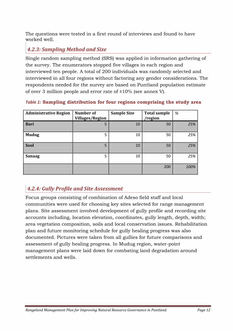
4.2.3: Sampling Method and Size
Single random sampling method (SRS) was applied in information gathering of
the survey. The enumerators stopped five villages in each region and
interviewed ten people. A total of 200 individuals was randomly selected and
interviewed in all four regions without factoring any gender considerations. The
respondents needed for the survey are based on Puntland population estimate
of over 3 million people and error rate of ±10% (see annex V).
Table 1: Sampling distribution for four regions comprising the study area
Administrative Region Number of Villages/Region
Sample Size Total sample /region
%
Bari 5 10 50 25%
Mudug 5 10 50 25%
Sool 5 10 50 25%
Sanaag 5 10 50 25%
200 100%
4.2.4: Gully Profile and Site Assessment
Focus groups consisting of combination of Adeso field staff and local
communities were used for choosing key sites selected for range management
plans. Site assessment involved development of gully profile and recording site
accounts including, location elevation, coordinates, gully length, depth, width;
area vegetation composition, soils and local conservation issues. Rehabilitation
plan and future monitoring schedule for gully healing progress was also
documented. Pictures were taken from all gullies for future comparisons and
assessment of gully healing progress. In Mudug region, water-point
management plans were laid down for combating land degradation around
settlements and wells.
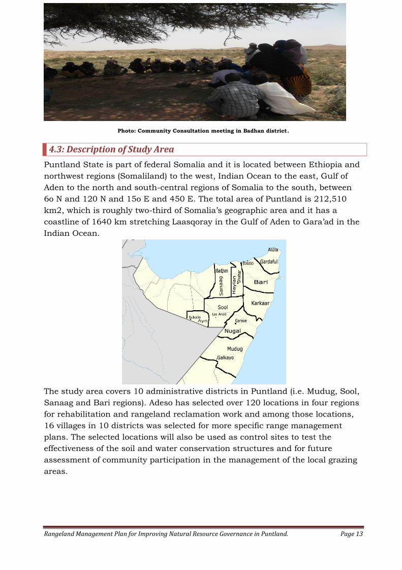
Rangeland Management Plan for Improving Natural Resource Governance in Puntland. Page 13
Photo: Community Consultation meeting in Badhan district.
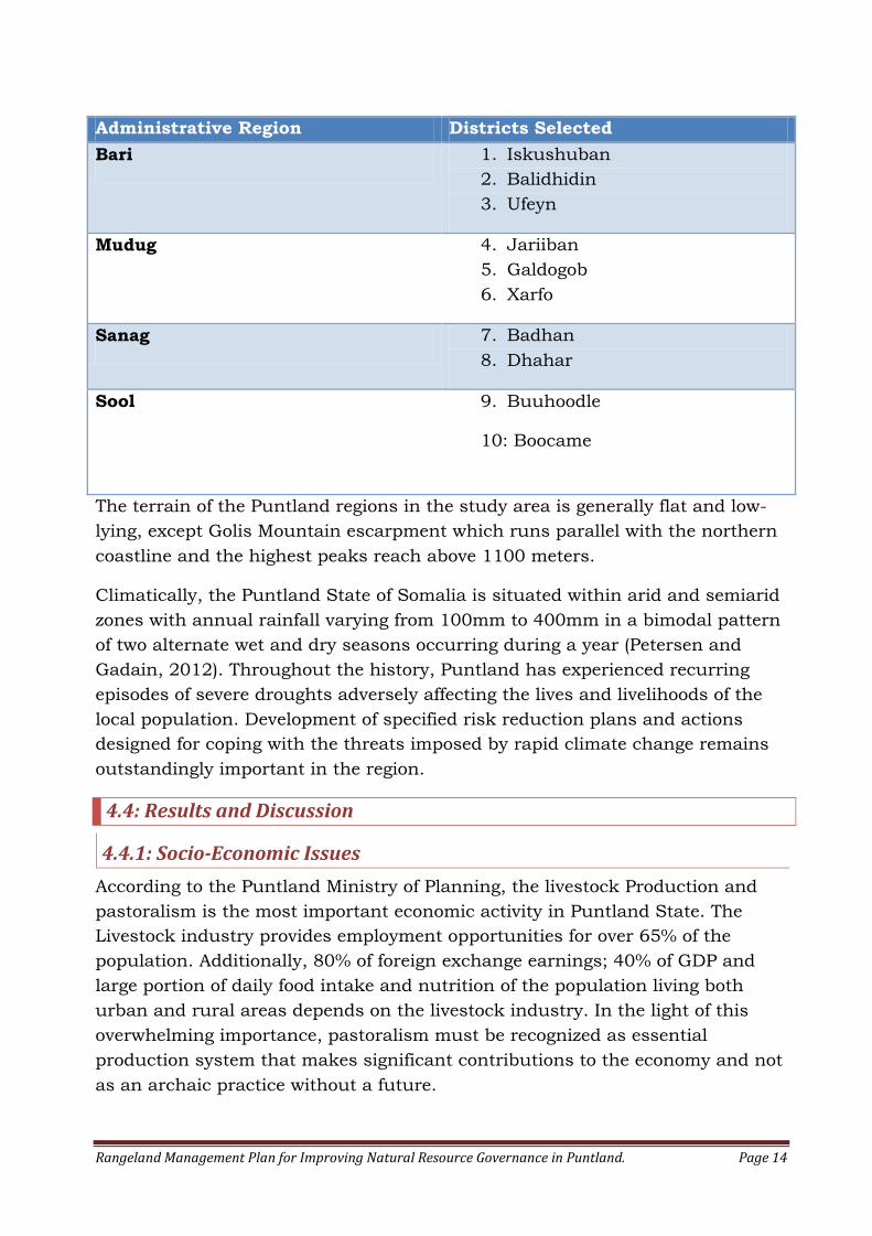
4.3: Description of Study Area
Puntland State is part of federal Somalia and it is located between Ethiopia and
northwest regions (Somaliland) to the west, Indian Ocean to the east, Gulf of
Aden to the north and south-central regions of Somalia to the south, between
6o N and 120 N and 15o E and 450 E. The total area of Puntland is 212,510
km2, which is roughly two-third of Somalia’s geographic area and it has a
coastline of 1640 km stretching Laasqoray in the Gulf of Aden to Gara’ad in the
Indian Ocean.
The study area covers 10 administrative districts in Puntland (i.e. Mudug, Sool,
Sanaag and Bari regions). Adeso has selected over 120 locations in four regions
for rehabilitation and rangeland reclamation work and among those locations,
16 villages in 10 districts was selected for more specific range management
plans. The selected locations will also be used as control sites to test the
effectiveness of the soil and water conservation structures and for future
assessment of community participation in the management of the local grazing
areas.
Rangeland Management Plan for Improving Natural Resource Governance in Puntland. Page 14
Administrative Region Districts Selected
Bari 1. Iskushuban
2. Balidhidin
3. Ufeyn
Mudug 4. Jariiban
5. Galdogob
6. Xarfo
Sanag 7. Badhan
8. Dhahar
Sool 9. Buuhoodle
10: Boocame
The terrain of the Puntland regions in the study area is generally flat and low-
lying, except Golis Mountain escarpment which runs parallel with the northern
coastline and the highest peaks reach above 1100 meters.
Climatically, the Puntland State of Somalia is situated within arid and semiarid
zones with annual rainfall varying from 100mm to 400mm in a bimodal pattern
of two alternate wet and dry seasons occurring during a year (Petersen and
Gadain, 2012). Throughout the history, Puntland has experienced recurring
episodes of severe droughts adversely affecting the lives and livelihoods of the
local population. Development of specified risk reduction plans and actions
designed for coping with the threats imposed by rapid climate change remains
outstandingly important in the region.
4.4: Results and Discussion
4.4.1: Socio-Economic Issues
According to the Puntland Ministry of Planning, the livestock Production and
pastoralism is the most important economic activity in Puntland State. The
Livestock industry provides employment opportunities for over 65% of the
population. Additionally, 80% of foreign exchange earnings; 40% of GDP and
large portion of daily food intake and nutrition of the population living both
urban and rural areas depends on the livestock industry. In the light of this
overwhelming importance, pastoralism must be recognized as essential
production system that makes significant contributions to the economy and not
as an archaic practice without a future.
Rangeland Management Plan for Improving Natural Resource Governance in Puntland. Page 15
Protection of pastoralism and pastoralists’ livelihoods requires preservation of
the rich plant resources that play a vital role in the livelihoods of the pastoral
communities in the region.
Furthermore, rangelands comprise 34% of Puntland’s landmass (Guyo, et al,
2013). Rangelands also serve as source of fresh water, clean air and open
spaces for recreation. Failure to develop a sustainable rangeland management
plans, policies and investments in the natural resource sector will exacerbate
environmental degradation, cause more resource-based conflicts, increase
poverty, prompt rural-urban migration and increase of illegal activities such
piracy and organized crimes.
4.4.2: General Vegetation Description
The richness and diversity of species is relatively high in the study area. In total
of 50 plants was identified as the dominant species, of which 47 species are
trees, woody shrubs and forbs, and three other species are grasses. Due to the
lack of a herbarium facility in Puntland to aid plant identification, some of
specimens could not be identified and thus only their vernacular names were
recorded.
Among the plant species found in the study area, there are number species of
interest, including Cordeauxia edulis, a plant known for its nutritious and tasty
nuts; Boswelia frereana , recognized as the king of all frankincense and a
commercially important tree; Acacia senegal or the gum Arabic tree, and the
Conocarpus lancifolius, an indigenous tree planted as pioneer species for
afforestation projects.
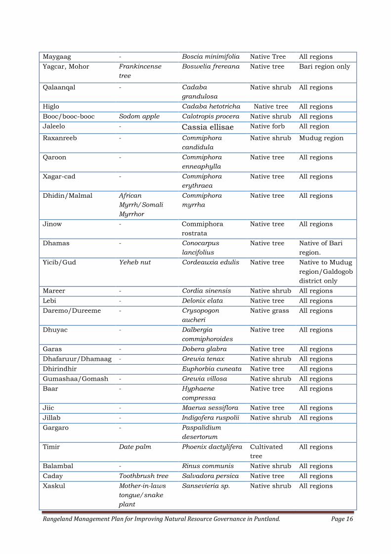
Table 2: Summary of Dominant Plant Species recorded in the study area
Vernacular Name
Common Name Botanical Name Vegetation
Type
Distribution/
Region
Qurac African umbrella
tree
Acacia tortillis Native Tree All region
Galool Acacia bussei Native tree All regions
Sarmaan - Acacia horrida Native Tree All regions
Bilcil Wait-a-bit-thorn Acacia mellifera Native Tree All regions
Cadaad Gum Arabic tree Acacia senegal Native Tree All regions
Qansax - Acacia reficiens Native Tree All regions
Gumar/Waysagad - Acacia stuhlmannii Native shrub All regions
Raydab - Albizia
anthelmintica
Native Tree All region
Kulan/shillin/Quud - Balanites
aegyptiaca
Native Tree All regions
Duur - Andropogon kelleri Native grass All regions
Rangeland Management Plan for Improving Natural Resource Governance in Puntland. Page 16
Maygaag - Boscia minimifolia Native Tree All regions
Yagcar, Mohor Frankincense
tree
Boswelia frereana Native tree Bari region only
Qalaanqal - Cadaba
grandulosa
Native shrub All regions
Higlo Cadaba hetotricha Native tree All regions
Booc/booc-booc Sodom apple Calotropis procera Native shrub All regions
Jaleelo - Cassia ellisae Native forb All region
Raxanreeb - Commiphora
candidula
Native shrub Mudug region
Qaroon - Commiphora
enneaphylla
Native tree All regions
Xagar-cad - Commiphora
erythraea
Native tree All regions
Dhidin/Malmal African
Myrrh/Somali
Myrrhor
Commiphora
myrrha
Native tree All regions
Jinow - Commiphora
rostrata
Native tree All regions
Dhamas - Conocarpus
lancifolius
Native tree Native of Bari
region.
Yicib/Gud Yeheb nut Cordeauxia edulis Native tree Native to Mudug
region/Galdogob
district only
Mareer - Cordia sinensis Native shrub All regions
Lebi - Delonix elata Native tree All regions
Daremo/Dureeme - Crysopogon
aucheri
Native grass All regions
Dhuyac - Dalbergia
commiphoroides
Native tree All regions
Garas - Dobera glabra Native tree All regions
Dhafaruur/Dhamaag - Grewia tenax Native shrub All regions
Dhirindhir Euphorbia cuneata Native tree All regions
Gumashaa/Gomash - Grewia villosa Native shrub All regions
Baar - Hyphaene
compressa
Native tree All regions
Jiic - Maerua sessiflora Native tree All regions
Jillab - Indigofera ruspolii Native shrub All regions
Gargaro - Paspalidium
desertorum
Timir Date palm Phoenix dactylifera Cultivated
tree
All regions
Balambal - Rinus communis Native shrub All regions
Caday Toothbrush tree Salvadora persica Native tree All regions
Xaskul Mother-in-laws
tongue/snake
plant
Sansevieria sp. Native shrub All regions
Rangeland Management Plan for Improving Natural Resource Governance in Puntland. Page 17
Daran - Sueda micromeris Native forb All regions
Salaamaco - Sesamothamnus
smithii
Native tree All regions
Raqay Tamarind/Indian
Date
Tamarindus indica Introduced
tree
Widely planted
in urban centres
Dhuur Salt Cedar Tamarix nilotica Native tree Bari & Sanaag
Bisiq - Terminalia
orbicularis
Native tree All regions
Hareeri - Terminalia spinosa Native tree All regions
Xamur - Ziziphus hamur Native tree All regions
Gob Chinese apple Zizyphus
mauritania
Native tree All regions
Aftaxole - Zygophyllium
hildebrandtii
Native shrub Bari, Sanaag
and Sool
Doomaar Unidentified Native grass Bari, Sool and
Sanaag
Shadaab - Unidentified Native shrub Sanaag
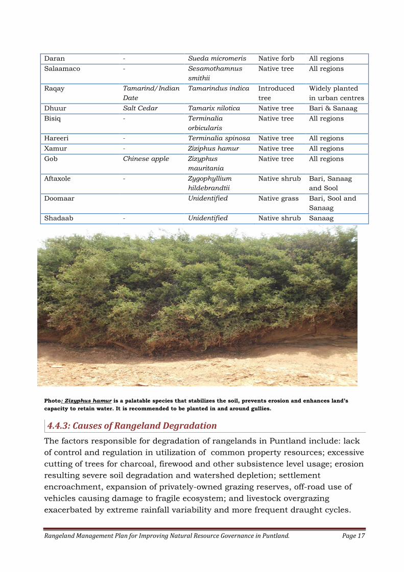
Photo: Zizyphus hamur is a palatable species that stabilizes the soil, prevents erosion and enhances land’s
capacity to retain water. It is recommended to be planted in and around gullies.
4.4.3: Causes of Rangeland Degradation
The factors responsible for degradation of rangelands in Puntland include: lack
of control and regulation in utilization of common property resources; excessive
cutting of trees for charcoal, firewood and other subsistence level usage; erosion
resulting severe soil degradation and watershed depletion; settlement
encroachment, expansion of privately-owned grazing reserves, off-road use of
vehicles causing damage to fragile ecosystem; and livestock overgrazing
exacerbated by extreme rainfall variability and more frequent draught cycles.
Rangeland Management Plan for Improving Natural Resource Governance in Puntland. Page 18
It widely accepted that, personal believes, attitudes and personal behaviour will
play important role in combating rangeland degradation and achieving land
stewardship (Guerin and Guerin 1994; Vanclay and Lawrence 1995 and
Yencken and Wilkinson 2000). In this study community perception is sought
for better understanding of rangeland conditions and to propose relevant
rangeland management strategies and action plans.
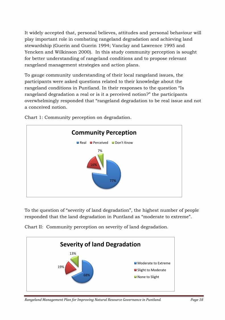
To gauge community understanding of their local rangeland issues, the
participants were asked questions related to their knowledge about the
rangeland conditions in Puntland. In their responses to the question “Is
rangeland degradation a real or is it a perceived notion?” the participants
overwhelmingly responded that “rangeland degradation to be real issue and not
a conceived notion.
Chart 1: Community perception on degradation.
To the question of “severity of land degradation”, the highest number of people
responded that the land degradation in Puntland as “moderate to extreme”.
Chart II: Community perception on severity of land degradation.
68%
19%
13%
Severity of land Degradation
Moderate to Extreme
Slight to Moderate
None to Slight
77%
16%
7%
Community Perception
Real Perceived Don't Know

Rangeland Management Plan for Improving Natural Resource Governance in Puntland. Page 19
To the question of the “root causes of rangeland degradation”, the common
theme was “combination of climatic changes and human activities”. Clear
majority of survey participants responded that climate change, together with
human activities to be cause, as well as results of land degradation in Puntland
State. Tree cutting and environmental pollution topped the list of human
activities causing the land degradation.
Chart III: Root Causes of Land degradation
To the question of “plant species in decline”, combination of participant
response and expert observations was used to determine the plant species in
decline and the causes of this decline.
Table 3: List of Species in Decline and Causes of Such Decline
Table 4: Species in Decline and Causes of Decline
Species in
Decline
Geographic
area
Human Action Climate
Change
Other factors
Acacia Tortillis
(qurac)
Mudug region Quicklime
production
Charcoal
yes
-
Dalbergia
commiphoroides
(Dhuyac)
All regions Overgrazing Yes Unexplained high
mortality
Ficus Spp. (Cajeel) Quicklime
production
yes -
Sporobolus
ruspolianus
(sifaar)
All regions Overgrazing yes -
Chrysopogon
aucheri (Dureeme)
All regions Overgrazing yes -
Andropogon
kelleri (duur)
All regions Roof thatching
for huts;
Covering
Berkads
yes Unexplained high
mortality
8%
21%
71%
Root Causes of land degradation
Climate Change
Human Activity
Combination-climate/Human
Rangeland Management Plan for Improving Natural Resource Governance in Puntland. Page 20
Gramineae Sp.
(Caws-qansax)
All regions Making “Raro”
or carpet-like
material for
nomadic huts
Yes Become near
extinct
(disappearance
not explained)
All Commiphora
Species
- Yes Unexplained high
mortality
To the questions of plant species increasing in numbers, the participants
unanimously agreed that an invasive exotic species named “ Prosopis juliflora” is
taking over large parts of rangelands in Puntland. Unpalatable native such as
Aftoxole (Zygophylium hildebrandtii) and Booc-Booc (Calotropis procera) are
also increasing in numbers.
4.4.4: Community Perception towards Land Stewardship
It is widely held believe, that the only viable way of achieving sustainable
rangeland management practice in Puntland is to employ a “bottom-up” or
community based approaches and therefore, understanding community
perceptions towards land stewardship is vitally important.
To the question of “responsibility of rangeland management”, the majority of
participant support “a joint government/community appointed body” to be
established in each district of Puntland for better management of rangeland. A
joint community/government body will be able to effectively utilize existing
government/community resources for better utilization of rangeland resources.
To the question of “protecting the environment from misuse at local level”,
overwhelming majority of the participants support “change of land tenure from
state ownership to customary land tenure and recognition of customary law in
Puntland courts” and that would constitute a major step forward for protecting
environment at local level.
4.4.5: The Reality of Common Resource
Resource such as pasture and water in Puntland is a common property and no
one effectively owns them. Major concern with common resource is over-
exploitation where user’s self-interest leads to devastation of resources over
time. The biologist Garrett Harding who popularized the term “tragedy of the
Commons” forty six years ago wrote the following:
“Therein is the tragedy. Each man is locked into a system that compels him to
increase his herd without limit - in a world that is limited. Ruin is the destination
toward which all men rush, each pursuing his own interest in a society that
believes in the freedom of the commons. (Hardin, 1968)
Rangeland Management Plan for Improving Natural Resource Governance in Puntland. Page 21
Destruction of common resource such as rangeland, trees and pasture will
ultimately be the disadvantage of everyone and livelihoods will be negatively
impacted.
Before independence in 1960, the land use in Puntland was classified under
traditional customary arrangements consisting of communal or village lands,
remote open access lands or rangelands and to lesser extent, private farmlands.
The successive governments in Somalia, in an attempt to create modern nation-
state and discourage tribalism have abolished communal land rights and made
open access lands as state land. The right of the communities to manage their
own lands was withdrawn and the government took all the responsibilities
(Unruh, 1995).
Elders in Jariiban District expressed “the tragedy” that followed after ending the
traditional customary property rights in the following manner:
“When our communities were told that you don’t own the land, the government
owns all the land was the time, when the concept of land stewardship was lost.
When something is not yours you do not take care of it.
After many decades, when we realized the very existence of our livelihood is at
stake, we decided to take action and developed our own customary laws for
protection and better management of our rangelands”.
Incidentally, both Puntland Constitution and the Environmental Policy support
return of traditional customary land tenure, use of customary law and transfer
of rangeland ownership from government to traditional authorities.
4.4.6: Rangeland Resource Use Conflicts
Millions of rural households, including pastoralist depend heavily on rangeland
resource use for their livelihoods. Other consumptive and non-consumptive
rangeland users include- small scale farmers, commercial pasture enclosure
owners, charcoal and quicklime burners, firewood gatherers, milk-collection
camp settlers and outdoor recreation users.
Conflict over use of rangeland in Puntland often rest on how the rights of use
are defined by the parties involved, whether they are based on traditional use or
specific property ownership. During this survey, discussions with the
community revealed causes for potential conflict over rangeland resource use.
The actions pertaining to use of rangelands that may trigger conflict has been
detailed in table 6
Rangeland Management Plan for Improving Natural Resource Governance in Puntland. Page 22
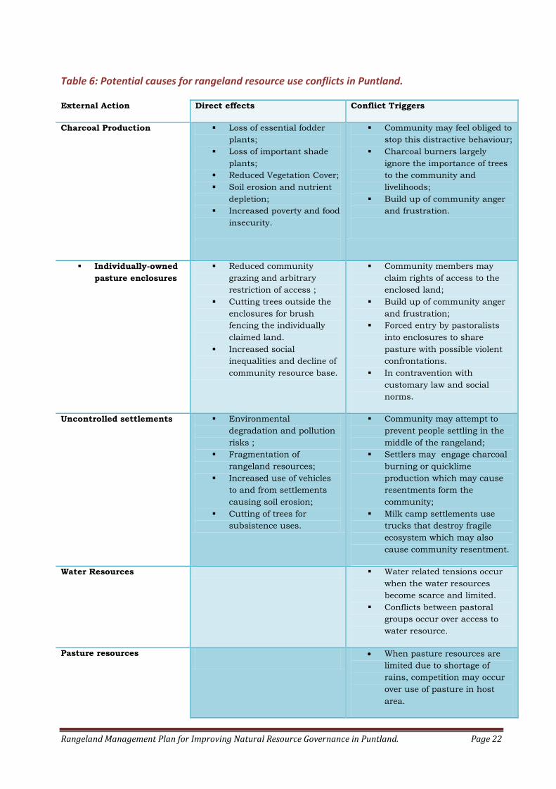
Table 6: Potential causes for rangeland resource use conflicts in Puntland.
External Action Direct effects Conflict Triggers
Charcoal Production Loss of essential fodder
plants;
Loss of important shade
plants;
Reduced Vegetation Cover;
Soil erosion and nutrient
depletion;
Increased poverty and food
insecurity.
Community may feel obliged to
stop this distractive behaviour;
Charcoal burners largely
ignore the importance of trees
to the community and
livelihoods;
Build up of community anger
and frustration.
Individually-owned
pasture enclosures
Reduced community
grazing and arbitrary
restriction of access ;
Cutting trees outside the
enclosures for brush
fencing the individually
claimed land.
Increased social
inequalities and decline of
community resource base.
Community members may
claim rights of access to the
enclosed land;
Build up of community anger
and frustration;
Forced entry by pastoralists
into enclosures to share
pasture with possible violent
confrontations.
In contravention with
customary law and social
norms.
Uncontrolled settlements Environmental
degradation and pollution
risks ;
Fragmentation of
rangeland resources;
Increased use of vehicles
to and from settlements
causing soil erosion;
Cutting of trees for
subsistence uses.
Community may attempt to
prevent people settling in the
middle of the rangeland;
Settlers may engage charcoal
burning or quicklime
production which may cause
resentments form the
community;
Milk camp settlements use
trucks that destroy fragile
ecosystem which may also
cause community resentment.
Water Resources Water related tensions occur
when the water resources
become scarce and limited.
Conflicts between pastoral
groups occur over access to
water resource.
Pasture resources When pasture resources are
limited due to shortage of
rains, competition may occur
over use of pasture in host
area.
Rangeland Management Plan for Improving Natural Resource Governance in Puntland. Page 23
5: RANGELAND MANAGEMENT HISTORY
5.1: History of Grazing Management in Somalia
Pastoralism is a branch of agriculture associated with the raising of livestock as
primary economic activity. Somalia possesses the greatest number of pastoralist
in Africa (Unruh, 1995). In the World stage, Mauritania and Mongolia are two
other countries where large number of population practice nomadic Pastoralism
(Aronson, 1979)
For centuries, pastoralists in the Puntland region of Somalia have raised cattle,
goats, sheep and camels for subsistence, transportation and creation of wealth.
Drought tolerant Somali goats are valued for their milk production and they
yield one to three kilograms of milk daily ((Neugebauer et al., 1991). In addition
to milk, meat and skin are other major products for goat production. The hardy
black-headed sheep are well adapted to dry climate in the country and they are
raised for meat, skin and commercial purposes. Camels are highly prized
among pastoral society in Somalia for their milk, meat and transportation of
goods. Camels play an important role in traditional social relations for
payments of dowries and clan compensations for victims in the case of death or
injury. Cattle are raised in Puntland, but much less numbers than goats, sheep
and camels.
The Somali pastoralists have rich understanding of their environment and have
developed sophisticated survival strategies and rangeland resource
management techniques, including: diversifications of livestock species,
mobility; maximization of stock numbers and the establishment of pattern of
behaviour in the customary law.
Diversification enables pastoralists to own different types of domestic animals
that can take advantage of existing vegetations for the purpose of ensuring the
availability of daily diet such as milk and meat. The average pastoralist
household in Puntland uses combination of grazers (goats and camels) and
browsers (cattle and sheep). Browsers feed on leaves, pods and softer branches
of trees and shrubs, whilst grazers feed on grasses and softer vegetation that
are closer to the ground. Mixing herds of grazers and browsers making use of
different feeding habits and grazing preferences could be beneficial for both
sustainable use of rangeland and gaining increased productivity in milk or meat
production.
Mobility enables the pastoralist to take advantage of seasonally available
pasture, water resources and salt patches. Pastoralists move from an area when
the pasture resources diminish and best available sites are chosen for grazing
Rangeland Management Plan for Improving Natural Resource Governance in Puntland. Page 24
and whilst the poorer sites are left to regenerate. Maximization of stock
numbers is another survival strategy that the Somali pastoralists use to ensure
survival of their herds despite losses during severe drought seasons and when
outbreaks of diseases occur.
In terms of rangeland resource management, the Somali pastoralist have
developed customary laws or traditional structures intended to bring order to
the lives of rangeland users, to resolve disputes and to sustainably use
rangeland resources. The history of when the Somali customary on grazing was
developed is unknown; however, many believe to be the oldest land use system
in Somalia. The rules dealing with grazing in the Somali customary law consist
of eleven covenants (see section 6.4.4) that has been passed orally from
generation to generation. These eleven covenants deal with the principles of
common ownership; procedures for conflict resolution, safe use of rangeland
resources and even how the visiting pastoralist from neighbouring community
should treated.
Rangeland improvement interventions and management in Somalia began in
1930s when the British Colonial Administration introduced grazing reserves in
the north (NRA, 1988). Following the establishment of the Department of
Natural Resources (DNR) in 1940s by the British Colonial Administration, range
and forestry guards were recruited from villages adjacent to the designated
grazing reserves for supervision and management of these reserves. After
independence in 1960s most of the grazing reserves collapsed due to lack of
financial support and rangeland management did not gain the necessary
attention until after the prolonged drought of 1973-1975 when major rangeland
development projects was launched (NRA,1988). List of rangeland projects and
measures since independence in 1960 has been detailed in Table 5.
Table 4: History of Range Management Projects and Measures in Somalia since Independence
in 1960.
Duration Project Name Achievements
1960 – 1970 Urban Tree planting projects Low level urban tree planting for municipalities.
1970-1972 Survey of the Northern
Rangelands
Inventory of range and livestock resources in northern regions;
Established 17 grazing reserves for dry season use
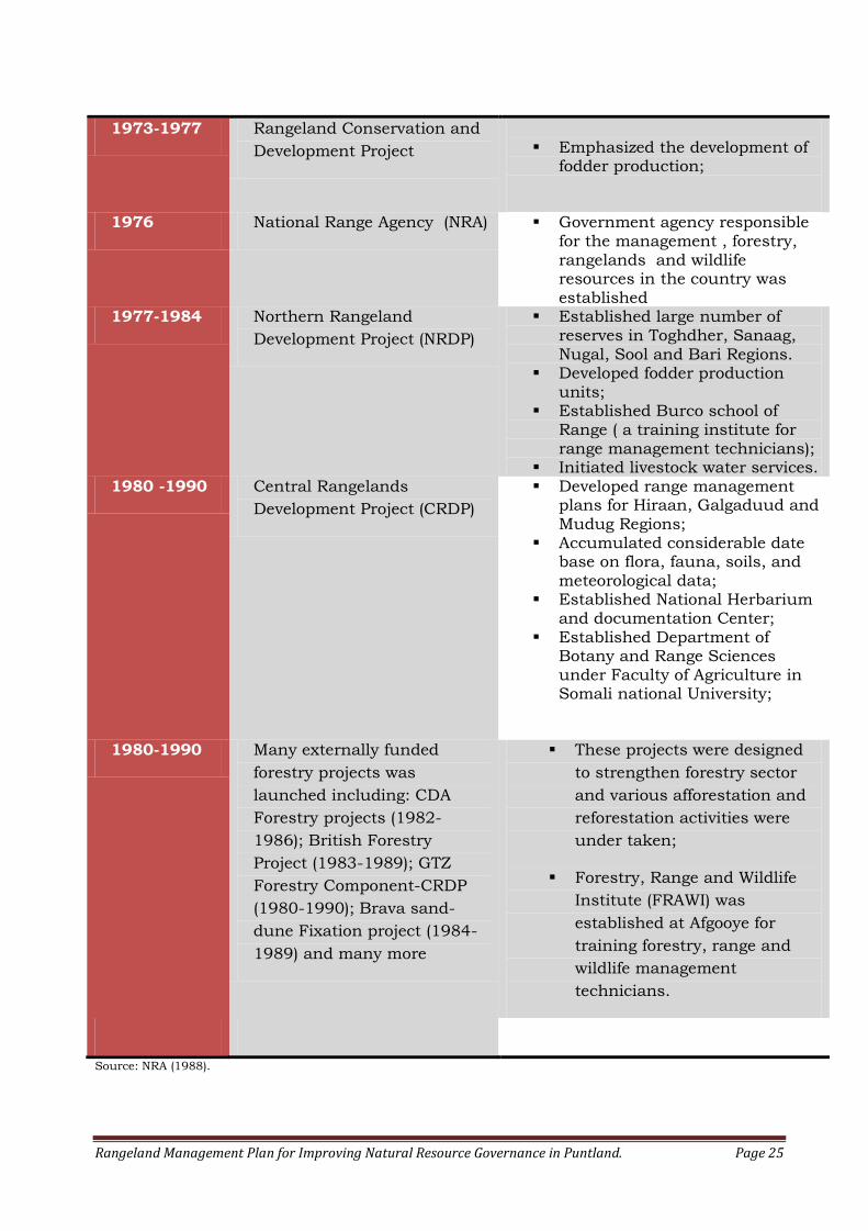
Rangeland Management Plan for Improving Natural Resource Governance in Puntland. Page 25
1973-1977 Rangeland Conservation and
Development Project
Emphasized the development of
fodder production;
1976 National Range Agency (NRA) Government agency responsible for the management , forestry, rangelands and wildlife resources in the country was established
1977-1984 Northern Rangeland
Development Project (NRDP)
Established large number of reserves in Toghdher, Sanaag,
Nugal, Sool and Bari Regions. Developed fodder production
units; Established Burco school of
Range ( a training institute for range management technicians);
Initiated livestock water services. 1980 -1990 Central Rangelands
Development Project (CRDP)
Developed range management plans for Hiraan, Galgaduud and Mudug Regions;
Accumulated considerable date base on flora, fauna, soils, and meteorological data;
Established National Herbarium and documentation Center;
Established Department of Botany and Range Sciences under Faculty of Agriculture in Somali national University;
1980-1990 Many externally funded
forestry projects was
launched including: CDA
Forestry projects (1982-
1986); British Forestry
Project (1983-1989); GTZ
Forestry Component-CRDP
(1980-1990); Brava sand-
dune Fixation project (1984-
1989) and many more
These projects were designed
to strengthen forestry sector
and various afforestation and
reforestation activities were
under taken;
Forestry, Range and Wildlife
Institute (FRAWI) was
established at Afgooye for
training forestry, range and
wildlife management
technicians.
Source: NRA (1988).

Rangeland Management Plan for Improving Natural Resource Governance in Puntland. Page 26
5.2: Review on Existing Policies and legal Frameworks
Currently, Puntland State has no specific legislation governing the natural
resources of the State. The Somali National Law on Fauna (Hunting) and Forest
Conservation, No.15 of 25 January, 1969 and the Law on Range management
and Development, No.3 of 4 February 1979 have long became obsolete and do
not cater for the prevailing conditions of the post conflict Somalia. Devolution
of environmental management from central government to regional authorities
in the new Federal Somalia has rendered yesterday’s laws and regulations badly
equipped in addressing today’s local needs and dealing with new environmental
challenges.
This new trend towards devolution based on sub-national legitimacy have lead
to the development of two policy documents on environment and natural
resource management in Puntland. Puntland Rangeland Management Policy
Document (Barre, 2009) and Draft Environmental Policy for Puntland (Jama,
2011) have both identified and emphasised the need for enactment of
environmental protection and natural resource management legislation for the
State.
A new constitution that was promulgated on 18, April 2012 became the
supreme legislation of Puntland State. This contains the duties, powers,
structure and function of the Government of Puntland. In this document,
Environmental Provisions are included in Article 48, under “Natural Resources”,
Article 49 under “protection of Environment” and Article 50 (2) under “rational
and sustainable use of resources”. In addition to that, the Puntland
Constitution under Article 116 (1) states that “The Puntland State’s system of
administration shall be based on decentralization” and thus confirms
devolution of environmental management to local and village levels.
5.3: Review on Rangeland Studies and literature
The availability of the data related to forestry, range and natural resource
management has always been both weak and poorly managed in Somalia. The
Lack of centralised data bank and poor knowledge management will continue to
hamper the progress towards achieving appropriate levels of environmental
resource management.
Bowen (1990) has compiled the first annotated bibliography of Forestry in
Somalia and Djibouti and a total of 617 papers relevant to forestry, range and
natural resources have been catalogued. Vegetation surveys and land use data
comprise the bulk of available literature pertaining to natural resource in
Somalia. Kempthorne (1884), Drake-Brockman (1912), Chiovenda (1916), Bravo
(1938), Chevalier (1939), Glover (1947), Gilliland (1952), Lawrie (1954),Griffiths
Rangeland Management Plan for Improving Natural Resource Governance in Puntland. Page 27
(1959), Hunt (1951), Boaler and Hodge (1962) and Hemming (1966) have all
conducted vegetation surveys and produced comprehensive accounts on flora of
Somalia.
Limited data specific to rangeland management in Puntland regions is currently
available. FAO (1972) described rangeland conditions in Mudug region and
recommended grazing reserves, especially, around livestock watering points.
Layzell and Mckay (1987) examined thirty-five eroded areas in Nugaal and Bari
regions and recorded occasional incidence of high levels of dead Acacia species
in Burtinle district of Nugaal region. Macfadyen (1950) also recorded dead trees
in the vicinity of deep gullies and concluded measures to be taken to check
gully erosion.
6: RANGELAND MANAGEMENT STRATEGIES AND ACTION PLAN
This section sets out how the rangelands in Puntland should be managed so
that the activities occurring on the land are compatible with the principles of
sustainable resource management in the rangelands. The rangeland
management strategies and action plans outlined in this document fall into
three categories; namely:
1. Long term strategy of setting management goals intended for addressing
root causes of range and forest resource depletion;
2. Short term action plan for identifying and restoring the most severely
degraded lands in Puntland state
3. Other Range Management Tools that can be utilized for better rangeland
management
6.1: Objectives
The overall objectives for development of rangeland resource management for
Puntland are:
a. to enhance the governance of natural resource in order to improve rural
livelihoods and reduce poverty;
b. to arrest and reverse decline of rangeland resources, and allow safe levels
of use;
c. to restore and maintain desired plant communities through proper
management;
d. to develop co-management of natural resources through participatory
process involving communities and government;
e. to restore severely degraded lands through construction of erosion control
and gully reclamation structures

Rangeland Management Plan for Improving Natural Resource Governance in Puntland. Page 28
6.2: Combating Drivers of Rangeland Degradation
This plan strives to provide specific measures that can be adopted for tackling
the drivers of land degradation in Puntland to the greatest extent possible.
As one elder in Ufeyn district put it “any meaningful rangeland management
plan should start with development of preventive measures to stop the attack
on the trees”. The management initiatives for combating rangeland degradation
are being detailed below under sections 6.2.1 to 6.2.9.
6.2.1: Supporting Enforcement of Customary Law
Degradation of rangeland in Puntland is of increasing worry to many including
pastoralists. Pastoralists in various regions in Puntland have expressed genuine
concern about the decreasing pasture, desertification of important grazing
lands, livestock mortality, and increased fragmentation of rangeland by
privately-owned pasture enclosures.
Many communities visited during this survey have urged organizing “a regional
environmental convention” to support enforcement and implementation of the
documented customary laws on region by region basis. A convention or formal
assembly of elders, traditional leaders, pastoralists and government officials is
recommended for holding discussions on local environmental issues and to
implement and enforce the documented customary laws on all regions in
Puntland. This recommended of gathering can be beneficial for the following
reasons:
Rangeland resource management will be set to take centre stage and the
outstanding issues will be addressed;
The community will be given an opportunity to review the documented
customary law and to re-affirm it;
The environmental customary law will be considered as the “law of land”
and enforcement procedures will be established;
Penalties for violation of customary laws will be reviewed and the
procedures for collecting penalty money will be established.
6.2.2: Recognition of Customary land Tenure
The question of who really “owns” the rangeland in Puntland and who will be
ultimately responsible for its protection from misuse at local level is an
important subject that needs to be addressed. Land tenure issues will continue
to have a major impact on sustainable use and sound management of
rangelands.
Rangeland Management Plan for Improving Natural Resource Governance in Puntland. Page 29
Land tenure is often categorized as private, communal, open access and state.
The constitution of former Somali Democratic Republic since 1961 clearly
stated that “The land, natural marine and land based resources shall be state
property” and this category of land tenure system remained in effect since the
total collapse of the state institutions in 1991. This unexpected collapse of the
central government and the public land ownership system that existed created
a classic case of “tragedy of the commons” under which the rangelands has
been freely and excessively exploited.
This plan encourages development of appropriate tenure framework that
supports recognition of customary land tenure and Somali customary law -Xeer.
Customary land tenure system recognizes the ownership of land by indigenous
communities and therefore, pastoral communities should be encouraged to
manage the rangelands under their customary arrangements. Governments
should intervene only after establishing causes of tenure insecurity, conflicts or
in the cases when customary land tenure creates bottle-necks to rural
development
6.2.3: Strengthening Community Based Institutions
Community based institutions is a general term applied to all organizations
controlled by the community. Recently formed Village Environmental
Committees (VEC) is the only formalized community based organization which
is involved in matters pertaining to environmental and natural resource
management in Puntland State. The capacity of Village Environmental
Committees should be strengthened to enable them participate the following
key functions:
a. Engaging the community, government and international development
partners from the onset of the planning processes;
b. Act as a voice for the community in the matters related to environmental
resource management and protection;
c. Participate annual “Environmental Week” celebrations as representatives
of local community to voice local environmental concerns and interpret
local changes;
d. Promote use of local customary law for environmental protection and
conflict resolution;
e. Support establishment of “Water-Point Management Committees” for
combating degradation of rangeland resources around settlements, wells
and other water-points;
f. Support establishment of grazing reserves and address threats associated
with decline of rangeland productivity and sustainability.
Rangeland Management Plan for Improving Natural Resource Governance in Puntland. Page 30
6.2.4: Integration of environmental considerations into Policy planning.
Integration of Environmental considerations into policy making processes
involves making sure that rangeland protection and other environmental
concerns are fully considered in the decisions and activities of all other sectors.
Environmental concerns are not always considered during planning, design and
construction of roads, buildings and other infrastructure projects.
Careless cutting of trees and leaving sites with extreme soil disturbance by
heavy machinery and diverted traffic during road construction are some of
classic cases observed in Puntland indicating that the necessary environmental
concerns were not observed. Refugees and internally displaced people (IDP) in
Puntland rely on natural woodlands for their survival and thus humanitarian
agencies should consider environment component in their settlement
programmes.
This plan encourages the government, industry and international development
agencies to consider innovative ways to reduce environmental impact on
rangelands and sensitive habitats that may be irrevocably damaged by various
activities and projects.
6.2.5: Halting Expansion of settlements
For the past twenty years, informal settlements such as small villages, semi-
permanent milk camps and water points have all increased exponentially.
Proliferation of settlements into the grazing lands has been a topic of active
debate for the past few years in Puntland. Overgrazing, depletion of woodlands
and other damages to environmental integrity is often concentrated in and
around villages, water points and other uncontrolled settlements. Some
settlements in Puntland have been abandoned when the surrounding
woodlands have been severely depleted, while new ones come into existence
every few years. This type of settlement proliferation is unsustainable and
therefore, regulatory measures for halting these new settlements are required.
6.2.6: Controlling Production of Charcoal and Fuelwood
Charcoal production and consumption for wood-energy is undoubtedly one of
the principal drivers of land degradations in Puntland. In the near future, LPG
supply infrastructure is expected to be developed in Puntland as an alternative
energy source in replacement for charcoal. Once the LPG and other alternative
energy sources become readily available in Puntland markets, all necessary
measures against wood energy burning must be promoted, including imposing
total ban on charcoal production.
Rangeland Management Plan for Improving Natural Resource Governance in Puntland. Page 31
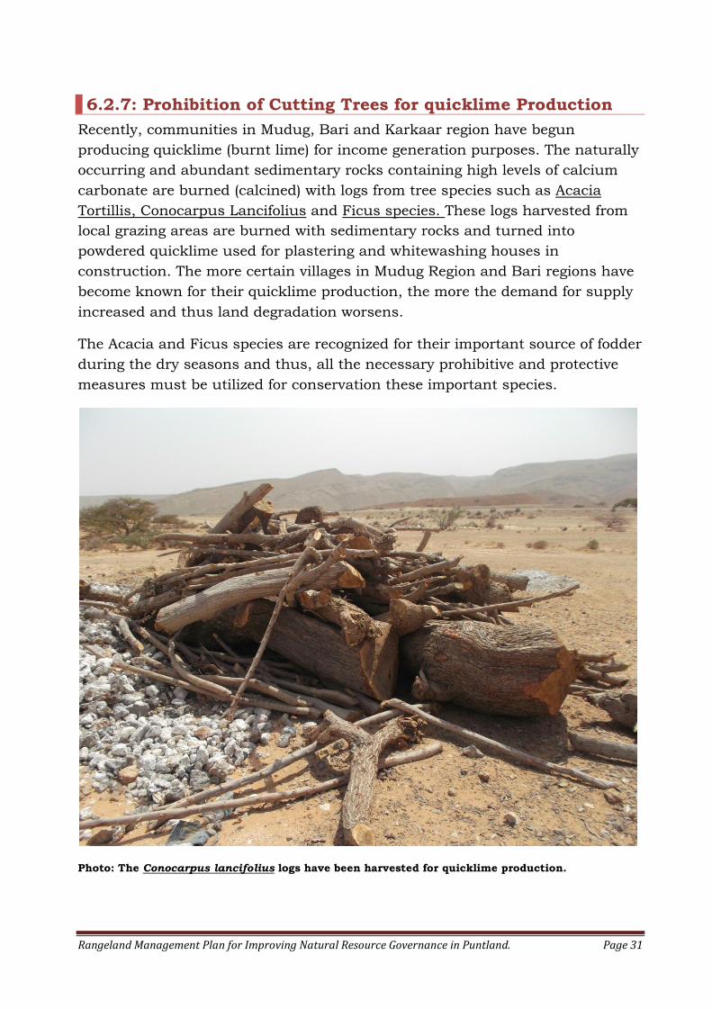
6.2.7: Prohibition of Cutting Trees for quicklime Production
Recently, communities in Mudug, Bari and Karkaar region have begun
producing quicklime (burnt lime) for income generation purposes. The naturally
occurring and abundant sedimentary rocks containing high levels of calcium
carbonate are burned (calcined) with logs from tree species such as Acacia
Tortillis, Conocarpus Lancifolius and Ficus species. These logs harvested from
local grazing areas are burned with sedimentary rocks and turned into
powdered quicklime used for plastering and whitewashing houses in
construction. The more certain villages in Mudug Region and Bari regions have
become known for their quicklime production, the more the demand for supply
increased and thus land degradation worsens.
The Acacia and Ficus species are recognized for their important source of fodder
during the dry seasons and thus, all the necessary prohibitive and protective
measures must be utilized for conservation these important species.
Photo: The Conocarpus lancifolius logs have been harvested for quicklime production.
Rangeland Management Plan for Improving Natural Resource Governance in Puntland. Page 32
6.2.8: Controlling Private grazing enclosures and Rangeland
Fragmentation
Appropriation of communal rangeland for private fodder enclosures has been
source conflict and debate among pastoralists in Puntland. Carving up plots of
communal lands by individuals for grazing and crop production, often without
the knowledge and consent of indigenous population has caused significant
changes to the traditional resource management strategies and the customary
laws that existed. This resource privatization restricts the movement of livestock
along traditional routes and across grazing areas. It also prevents pastoralists
to enter areas, when in the past they would have used those areas for grazing
without any individuals claiming ownership or any special rights.
6.2.9: Preventing Soil Erosion, Bush Encroachment and Invasive Exotic Species.
A typical rangeland in Puntland consists mainly of thorn-bush savannah, with
various Commiphora, Acacia and succulent species, along with herbaceous
vegetation, forbs and grasses that are grazed or have the potential to be grazed.
Rangeland productivity in Puntland is threatened by land degradation
characterized by soil erosion; Acacia bush encroachment, loss of herbaceous
and perennial grasses and invasion of foreign plant species. The degradation of
rangeland often begins with the loss of palatable annuals, perennials and
herbaceous vegetation that are close to the forest floors. Common grasses such
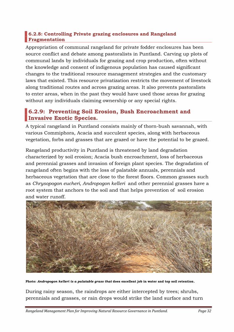
as Chrysopogon eucheri, Andropogon kelleri and other perennial grasses have a
root system that anchors to the soil and that helps prevention of soil erosion
and water runoff.
Photo: Andropogon kelleri is a palatable grass that does excellent job in water and top soil retention.
During rainy season, the raindrops are either intercepted by trees; shrubs,
perennials and grasses, or rain drops would strike the land surface and turn
Rangeland Management Plan for Improving Natural Resource Governance in Puntland. Page 33
into overland flow causing soil erosion. Improving the undergrowth of
herbaceous perennials, grasses and availability of woody debris in the forest
floors increase forest water holding capacity and water infiltration and in turn
reduce water runoff and soil erosion, and that will eventually improve rangeland
productivity.
It is very important to acknowledge the importance of perennials and grasses to
the overall health and productivity of rangelands, and thus serious efforts must
be made to reduce harvesting of Andropogon kelleri., for hut thatching, covering
berkad reservoirs and other uses. Andropogon kelleri which is known as “duur”
in Somali language is a tall, erect, coarse and very palatable perennial grass
that once covered large parts of Puntland State.
In the recent past, many pastoral communities in Puntland have observed and
expressed concern about a new phenomenon involving increase of Acacia
species (Geed Xanan) and decline of Commiphora species (Geed Quwaax),
perennial undergrowth and common grasses. This new phenomenon is termed
as “Bush Encroachment” and often involves transformation of the rangeland to
a tree-dominated ecosystem through a process known as plant succession.
Further research is needed to study this change in the ecosystem brought
about by the progressive replacement of one plant community by another and
the overall effect to the rangeland productivity.
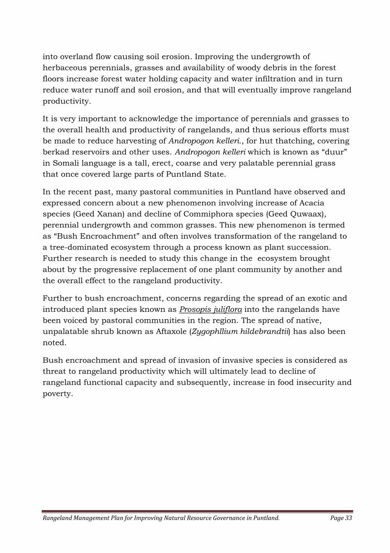
Further to bush encroachment, concerns regarding the spread of an exotic and
introduced plant species known as Prosopis juliflora into the rangelands have
been voiced by pastoral communities in the region. The spread of native,
unpalatable shrub known as Aftaxole (Zygophllium hildebrandtii) has also been
noted.
Bush encroachment and spread of invasion of invasive species is considered as
threat to rangeland productivity which will ultimately lead to decline of
rangeland functional capacity and subsequently, increase in food insecurity and
poverty.
Rangeland Management Plan for Improving Natural Resource Governance in Puntland. Page 34
Photo: Prosopis juliflora is an invasive, exotic plant species that threatens important agricultural and
grazing valleys in Puntland. The photo was taken in Laag oasis near Bosasso
6.2.10: Controlling Use of Heavy Trucks in the Rangeland
Use of heavy transportation trucks for moving livestock, people and goods pose
potential threats to the ecologically fragile rangelands in the State. Nowadays,
when rains are partial and sporadic, pastoralists use heavy trucks to transport
their livestock faster to destination where spells of rain had occurred in order to
be first ones to arrive and take advantage of fresh pasture. These heavy trucks
leave indelible marks forever on the landscape. They compact the soils and
destroy the living soil crusts that forms the foundation for plant life in the
desert-like environment of Puntland.
Off-road vehicles (ORV) cause extraordinary amount of habitat degradation and
consequently, serious efforts must be made to reduce off-road driving of trucks.
6.3: Rehabilitation of Severely Degraded Areas
For over two decades, pastoral communities in Puntland have helplessly
watched as their valuable pasture lands wasted away by unrelenting gully
erosion. Today, there is sight of hope due to the intervention of the “Your
Environment is your life”, a project funded by the European Union (EU) in
collaboration with the Ministry of Environment, Wildlife and Tourism, the
African Development Solutions (Adeso) and The Care International. This project
supports restoration of rangelands and enhancing livelihood resilience.
Some of the control and rehabilitation measures undertaken by this project
include:
Rangeland Management Plan for Improving Natural Resource Governance in Puntland. Page 35
1. Selection of the most severely degraded lands in Puntland through
community participation;
2. Identifying the source of runoff that is causing gully erosion;
3. Surveying the selected areas and creating the profile of the gullies;
4. Rehabilitation of gullies through construction of erosion control and gully
reclamation structures, and
5. Monitoring the gully healing progress.
6.3.1: Selection Severely Degraded Lands
Gully erosion is highly visible form of land degradation that affects the
rangeland and soil productivity. It obstructs pastoral mobility, restricts land use
and threatens roads, buildings and grazing lands in the Puntland State.
Vegetation is the important weapon that can be used against controlling gully
erosion, but structures are needed for stabilization of gully head and promotion
of plant life in the gully floor. Structures, whether be masonry, wood or other
building material tend to deteriorate over time, on the other hand, vegetation
tends to thrive, multiply and improve over time.
Gully erosion is wide spread feature in the arid and semi-arid regions of
Puntland State and therefore, planning and control measures to mitigate gully
erosion requires community participation.
The existing Village Environmental Committees (VEC) from various districts was
involved in selecting the priority areas for gully control and land rehabilitation
activities. The community gully selection process was based on the following
criteria:
Loss of rangeland productivity or gullies occurring the most productive
area of the watershed;
Dissection and fragmentation of grazing land or gullies creating
difficulties with access and mobility, and;
Damage to infrastructures such as roads, bridges, culverts, buildings,
and transportation routes.
The selected locations served important rangelands for pastoral production and
the gully rehabilitation process has been implemented by Adeso in a bid to
restore rangeland productivity and livelihood resilience. A total of 118 gullies
has been selected for restorations and among them key sites were selected for
in-depth site assessment and as allotments for rangeland management plans.
Rangeland Management Plan for Improving Natural Resource Governance in Puntland. Page 36
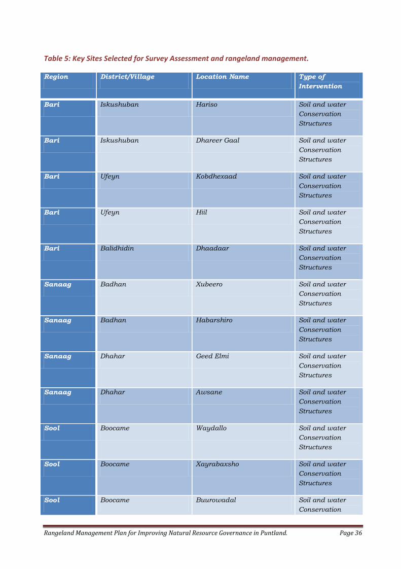
Table 5: Key Sites Selected for Survey Assessment and rangeland management.
Region District/Village Location Name Type of
Intervention
Bari Iskushuban Hariso Soil and water
Conservation
Structures
Bari Iskushuban Dhareer Gaal Soil and water
Conservation
Structures
Bari Ufeyn Kobdhexaad Soil and water
Conservation
Structures
Bari Ufeyn Hiil Soil and water
Conservation
Structures
Bari Balidhidin Dhaadaar Soil and water
Conservation
Structures
Sanaag Badhan Xubeero Soil and water
Conservation
Structures
Sanaag Badhan Habarshiro Soil and water
Conservation
Structures
Sanaag Dhahar Geed Elmi Soil and water
Conservation
Structures
Sanaag Dhahar Awsane Soil and water
Conservation
Structures
Sool Boocame Waydallo Soil and water
Conservation
Structures
Sool Boocame Xayrabaxsho Soil and water
Conservation
Structures
Sool Boocame Buurowadal Soil and water
Conservation
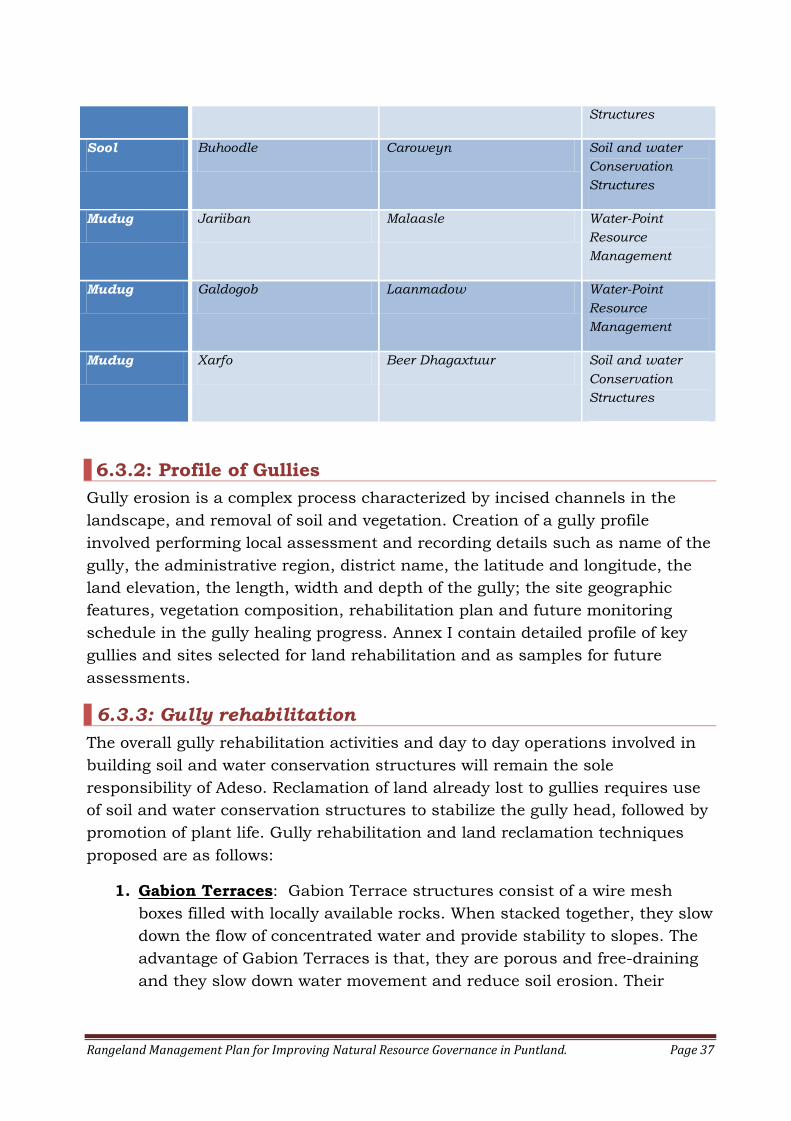
Rangeland Management Plan for Improving Natural Resource Governance in Puntland. Page 37
Structures
Sool Buhoodle Caroweyn Soil and water
Conservation
Structures
Mudug Jariiban Malaasle Water-Point
Resource
Management
Mudug Galdogob Laanmadow Water-Point
Resource
Management
Mudug Xarfo Beer Dhagaxtuur Soil and water
Conservation
Structures
6.3.2: Profile of Gullies
Gully erosion is a complex process characterized by incised channels in the
landscape, and removal of soil and vegetation. Creation of a gully profile
involved performing local assessment and recording details such as name of the
gully, the administrative region, district name, the latitude and longitude, the
land elevation, the length, width and depth of the gully; the site geographic
features, vegetation composition, rehabilitation plan and future monitoring
schedule in the gully healing progress. Annex I contain detailed profile of key
gullies and sites selected for land rehabilitation and as samples for future
assessments.
6.3.3: Gully rehabilitation
The overall gully rehabilitation activities and day to day operations involved in
building soil and water conservation structures will remain the sole
responsibility of Adeso. Reclamation of land already lost to gullies requires use
of soil and water conservation structures to stabilize the gully head, followed by
promotion of plant life. Gully rehabilitation and land reclamation techniques
proposed are as follows:
1. Gabion Terraces: Gabion Terrace structures consist of a wire mesh
boxes filled with locally available rocks. When stacked together, they slow
down the flow of concentrated water and provide stability to slopes. The
advantage of Gabion Terraces is that, they are porous and free-draining
and they slow down water movement and reduce soil erosion. Their
Rangeland Management Plan for Improving Natural Resource Governance in Puntland. Page 38
disadvantage is that, if not correctly installed, they may quickly fail and
cause more erosion.
2. Rock Check Dams: Rock Check Dam Structures are small barriers or
dams constructed across a gully, drainage ditch or any other
concentrated flow area for the purpose of gully erosion stabilization and
erosion control. It is very important to ensure that check Dam structures
are properly spaced, well keyed into the banks of the gullies and flow of
water directed into the middle of structure by creating notches in the
channel bottom for Scour protection.
Important Note: Removal of stones from rangeland should be
approached with caution since these stones are natural habitat to many
organisms such as ants, termites, beetles, woodlice, centipedes, slugs,
spiders, scorpions and many other soil microorganisms. These organisms
are soil builders and miners and destroying their habitats may cause new
form of erosion.
3. Diversion Ditches: Diversion Ditches are permanent shallow
depressions in the ground for controlling erosion by collecting or re-
directing water and slowing down the rate of runoff into stable outlets.
4. Semi-Circular Soil Bunds: Semi-circular bunds are constructed to
collect surface water run-off, increase infiltration and prevent soil
erosion. Bunds are often built with stones or soil. Bunds can be
constructed on any terrain, from flat ground to steep slopes. Due to
semi-circular shape, bunds are suited for planting individual trees.
5. Heavy Machinery: In the cases where the gully walls or sides are deep
and steep, heavy machinery might be required to obliterate the steep
slopes and to partially fill the gully.
6. Planting and Seeding: Seeding and planting should follow soon after
building check dams, or gabion structures are completed. Soil and water
conservation structures often fail if the treatment does not include a
vegetation cover. The vegetation cover of the reclaimed area can be
speeded up by using vegetative propagation techniques such as use of
Commiphora Spp. Cuttings.
7. Crushing. Crushing involves breaking the hard surface crust of the soil
for increasing water percolation into the soil. The surface crust gets hard
and brittle when dry than the material immediately beneath the top
layer. Crushing is carried out to increase water infiltration into the soil
and encourage return of vegetation cover.
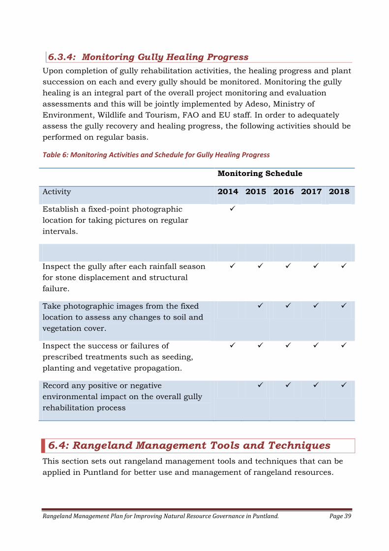
Rangeland Management Plan for Improving Natural Resource Governance in Puntland. Page 39
6.3.4: Monitoring Gully Healing Progress
Upon completion of gully rehabilitation activities, the healing progress and plant
succession on each and every gully should be monitored. Monitoring the gully
healing is an integral part of the overall project monitoring and evaluation
assessments and this will be jointly implemented by Adeso, Ministry of
Environment, Wildlife and Tourism, FAO and EU staff. In order to adequately
assess the gully recovery and healing progress, the following activities should be
performed on regular basis.
Table 6: Monitoring Activities and Schedule for Gully Healing Progress
Monitoring Schedule
Activity 2014 2015 2016 2017 2018
Establish a fixed-point photographic
location for taking pictures on regular
intervals.
Inspect the gully after each rainfall season
for stone displacement and structural
failure.
Take photographic images from the fixed
location to assess any changes to soil and
vegetation cover.
Inspect the success or failures of
prescribed treatments such as seeding,
planting and vegetative propagation.
Record any positive or negative
environmental impact on the overall gully
rehabilitation process
6.4: Rangeland Management Tools and Techniques
This section sets out rangeland management tools and techniques that can be
applied in Puntland for better use and management of rangeland resources.
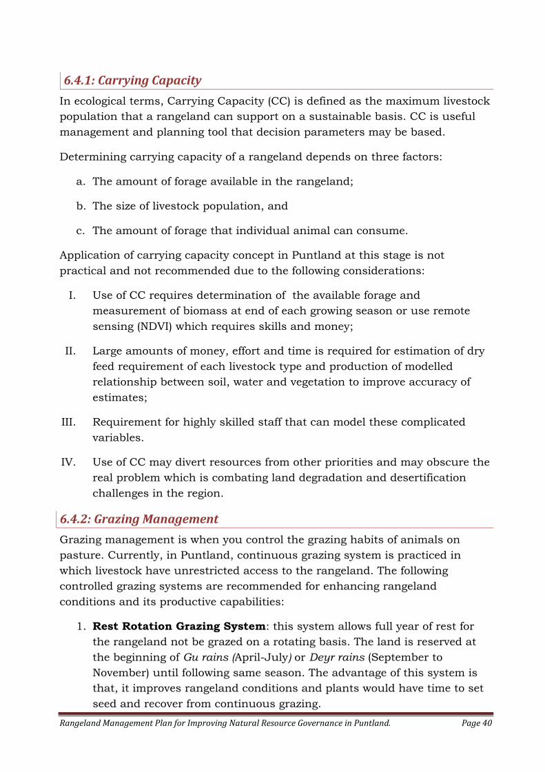
Rangeland Management Plan for Improving Natural Resource Governance in Puntland. Page 40
6.4.1: Carrying Capacity
In ecological terms, Carrying Capacity (CC) is defined as the maximum livestock
population that a rangeland can support on a sustainable basis. CC is useful
management and planning tool that decision parameters may be based.
Determining carrying capacity of a rangeland depends on three factors:
a. The amount of forage available in the rangeland;
b. The size of livestock population, and
c. The amount of forage that individual animal can consume.
Application of carrying capacity concept in Puntland at this stage is not
practical and not recommended due to the following considerations:
I. Use of CC requires determination of the available forage and
measurement of biomass at end of each growing season or use remote
sensing (NDVI) which requires skills and money;
II. Large amounts of money, effort and time is required for estimation of dry
feed requirement of each livestock type and production of modelled
relationship between soil, water and vegetation to improve accuracy of
estimates;
III. Requirement for highly skilled staff that can model these complicated
variables.
IV. Use of CC may divert resources from other priorities and may obscure the
real problem which is combating land degradation and desertification
challenges in the region.
6.4.2: Grazing Management
Grazing management is when you control the grazing habits of animals on
pasture. Currently, in Puntland, continuous grazing system is practiced in
which livestock have unrestricted access to the rangeland. The following
controlled grazing systems are recommended for enhancing rangeland
conditions and its productive capabilities:
1. Rest Rotation Grazing System: this system allows full year of rest for
the rangeland not be grazed on a rotating basis. The land is reserved at
the beginning of Gu rains (April-July) or Deyr rains (September to
November) until following same season. The advantage of this system is
that, it improves rangeland conditions and plants would have time to set
seed and recover from continuous grazing.

Rangeland Management Plan for Improving Natural Resource Governance in Puntland. Page 41
2. Deferred Grazing System: this system allows delay of grazing after
growth seasons has started (i.e. either Gu or Deyr rains) until key forage
species set seed and seeds mature. This improves plant vigour, seed
availability and regeneration of vegetation.
3. Drought-Time Grazing reserves: this type of grazing reserves are
needed as the first response for cyclical droughts that occur in Puntland
which often result shortage of pasture, livestock mortality and water
scarcity. A phenomenon known as “Dabadheer” or “the prolonged
drought” occurs every ten years throughout Somalia, especially years
ending with four. Rains have failed in Somalia during the Gu seasons and
severe droughts have occurred in 1964, 1974, 1984, 1994.2004 and now
2014 some of which degenerated into a full-blown famine. The drought of
1974 was particularly harsh and it is remembered for its wide spread
starvation and devastation of pastoral economy. Protected areas set aside
as drought-time grazing reserves need to be established in all regions of
Puntland. Many people interviewed in the study area have welcomed the
idea.
6.4.3: Water Point Management
Water sources such as shallow wells, boreholes and berkads or cemented
cisterns are often associated with land degradation characterized by
considerable overgrazing and soil degradation.
Pastoralists allow hungry animals to freely graze around wells or Berkad
reservoirs on each watering interval, usually after a long distance of trek for
water. Large herds of animals coming to the same watering points consume a
lot on each visit, often leaving area around watering points bare and overgrazed.
Additionally, the owners of berkads continuously cut Acacia species for brush
fencing around their Berkads which results removal of large number of trees
each year. In Some areas, the Berkad owners, also continuously cut Duur grass
(Andropogon kelleri) for Berkad thatching and that creates loss of important
palatable grass vital for soil and water conservation. Council of elders or
Community Well Management Committee (CWMC) should be established for
combating environmental degradation at water-point level. Establishment of
formal organization for controlling and managing community wells are needed
for the following reasons:
1. Well Management Committee may create customary rules, establish
reserves at water-points and protect the environment from misuse;
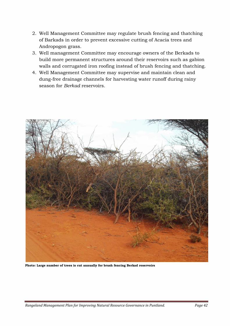
Rangeland Management Plan for Improving Natural Resource Governance in Puntland. Page 42
2. Well Management Committee may regulate brush fencing and thatching
of Barkads in order to prevent excessive cutting of Acacia trees and
Andropogon grass.
3. Well management Committee may encourage owners of the Berkads to
build more permanent structures around their reservoirs such as gabion
walls and corrugated iron roofing instead of brush fencing and thatching.
4. Well Management Committee may supervise and maintain clean and
dung-free drainage channels for harvesting water runoff during rainy
season for Berkad reservoirs.
Photo: Large number of trees is cut annually for brush fencing Berkad reservoirs
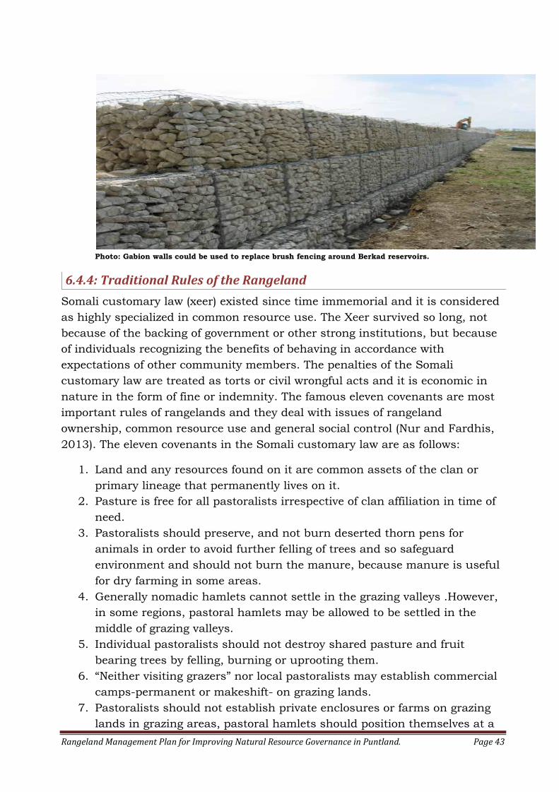
Rangeland Management Plan for Improving Natural Resource Governance in Puntland. Page 43
Photo: Gabion walls could be used to replace brush fencing around Berkad reservoirs.
6.4.4: Traditional Rules of the Rangeland
Somali customary law (xeer) existed since time immemorial and it is considered
as highly specialized in common resource use. The Xeer survived so long, not
because of the backing of government or other strong institutions, but because
of individuals recognizing the benefits of behaving in accordance with
expectations of other community members. The penalties of the Somali
customary law are treated as torts or civil wrongful acts and it is economic in
nature in the form of fine or indemnity. The famous eleven covenants are most
important rules of rangelands and they deal with issues of rangeland
ownership, common resource use and general social control (Nur and Fardhis,
2013). The eleven covenants in the Somali customary law are as follows:
1. Land and any resources found on it are common assets of the clan or
primary lineage that permanently lives on it.
2. Pasture is free for all pastoralists irrespective of clan affiliation in time of
need.
3. Pastoralists should preserve, and not burn deserted thorn pens for
animals in order to avoid further felling of trees and so safeguard
environment and should not burn the manure, because manure is useful
for dry farming in some areas.
4. Generally nomadic hamlets cannot settle in the grazing valleys .However,
in some regions, pastoral hamlets may be allowed to be settled in the
middle of grazing valleys.
5. Individual pastoralists should not destroy shared pasture and fruit
bearing trees by felling, burning or uprooting them.
6. “Neither visiting grazers” nor local pastoralists may establish commercial
camps-permanent or makeshift- on grazing lands.
7. Pastoralists should not establish private enclosures or farms on grazing
lands in grazing areas, pastoral hamlets should position themselves at a

Rangeland Management Plan for Improving Natural Resource Governance in Puntland. Page 44
distance of at least one kilometre from each other to allow space for
livestock to graze in the morning and evening. No one is allowed to cut
green grass and to transport it to another area.
8. Visiting grazers must respect grazing customary law, and maintain
peaceful coexistence with host communities.
9. A committee of elders from the visiting group and local community is
empowered to resolve any differences that arise between the two
communities.
10. Kinsmen should assist each other in hard times, particularly
during long migrations to distant locations in search of rains or water in
distant wells.
11. To reserve an old pen for his own use, the head of a pastoralist
group should clearly leave a mark in the front of the pen to ward off
“pretenders”.
There are also other three widely accepted basic rules practiced by the
Somali pastoralists for regulating individual or group behaviour. These are:
1. Avoid area that is already in use by other pastoralists;
2. Keep at a suitable distance from others;
3. Avoid areas that are recently vacated by others
7: IMPLEMENTATION AND REVIEW OF THE PLAN
Implementation plan for rangeland management is a national approach
intended to identify strategy direction for achieving better governance of natural
resources in Puntland. The success of this management plan is predicted on the
following four elements:
1. Prevention: Addressing all underlying causes for rangeland degradation
detailed in this plan;
2. Rehabilitation and Restoration: Restore and reclaim all severely
degraded grazing lands and enhance rangeland productivity;
3. Community Empowerment and Collaboration: Strengthen community
based institutions for protection and management of rangeland resources
at local level;
4. Communication and Education: Organize community meetings on
region by region basis to set environmental protection and sustainable
use of rangeland resources at centre stage and to disseminate customary
law.
This plan should be reviewed on 5-year cycle. The 5-year cycle review allows
enough time to address overall management strategies in this plan. It is
Rangeland Management Plan for Improving Natural Resource Governance in Puntland. Page 45
assumed that some of the key strategies such as development of alternative
source of energy to replace charcoal use and other underlying causes of land
degradation will take minimum of five years to be fully addressed. If
required, amendments can be made to revise, update or add management
directions.
The review process may be conducted by the partners of the NRM program,
namely, Ministry of Environment, Wildlife and Tourism, Adeso, Care
International, FAO and EU.
8: CONCLUSION
Rangelands play critical role in the livelihoods and in household food
security in Puntland. According NRM Baseline Survey Report, rangelands
comprise approximately 34% of Puntland’s landmass. They provide valuable
grazing lands to livestock and Puntland’s economy largely depends on the
livestock industry. Rangelands also serve as source of fresh water, clean air
and open spaces for recreation.
In the light of this overwhelming importance and because of the diversity of
goods and services derived from rangelands, their management is considered
as an issue of national importance and thus closely linked to the economic
wellbeing of the people of Puntland.
Combating key drivers of land degradation, restoration of severely degraded
lands and community empowerment constitute the principal strategies for
improving rangeland governance in Puntland State.
Customary law is considered as an important local tool for natural resource
protection and thus effort should be made to disseminate and encourage its
use.
Establishment of Joint Environmental Committees (JEC) comprising local
community members, Ministry of Environment, local government and law
enforcement agencies is recommended for harnessing all available local
resources for protection and proper use of natural resources at local level.
Rangeland Management Plan for Improving Natural Resource Governance in Puntland. Page 46
9: ADDENDUM
Rangeland Management Plan for Improving Natural Resource Governance in Puntland. Page 47
Annex I: Gully Profile and Site Accounts
Fourteen gullies situated in vital grazing areas and two villages with numerous
Berkad reservoirs were selected for profiling and site account review. These
locations will be used as control sites for future assessments and evaluation for
the effectiveness of soil and water conservation structures and the levels of
community involvement in the management of the rehabilitated areas.
Name:Kobdhexaad1 Latitude:10.65455
Admin Region: Bari Region
District: Ufeyn
Longitude:49.50555
Dimension: Stretches approx.15km long Altitude: 505m
Site Description: The site is located on the outskirt of Kobdhexaad Village in
Ufeyn District of Bari region. Kobdhexaad is an important grazing valley that
supports pastoral community of over 5000 people. It is low-lying and exposed
with compacted alluvial soils. There are several sporadically occurring plants on
the site and vegetation cover is principally Acacia Tortillis, Zizyphus hamur,
Acacia hortida and Paspalidium desertorum grasses.
Conservation Issues: Desertification, soil erosion, loss of soil fertility, poor
water retention and soil compaction.
Rehabilitation Plan: Semi-circular soil bunds have been constructed by Adeso
for retention of water run-off, to increase water percolation and encourage
vegetation growth.
Management: Since the site is very close to Kobdhexaad village, the
community was encouraged to carry out soil cultivation by breaking the soil
crust and to spread manure for gradual return of vegetation. Upon return of
Rangeland Management Plan for Improving Natural Resource Governance in Puntland. Page 48
vegetation cover, deferred grazing system should be implemented by
community.
Name:Harriso1 Latitude:10.45188333
Admin Region: Bari Region
District: Iskushuban
Longitude: 49.80368333
Length: Stretches approx. 30 km Altitude: 386m
Site Description: Hariso Gully is located on the outskirt of Meeladeen village in
Iskushuban district of Bari region. The site is located an important grazing area
in Dharoor valley. Hariso supports large number of pastoral families. It is low-
lying and exposed with alluvial soil type. There are several sporadically
occurring plants and the available vegetation include, Andropogon
kelleri,Tamarix nilotica and Acacia Tortillis.
Conservation Issues: Unrelenting gully erosion is wasting more and more
grazing lands every year. Surface water and accumulated sediment created
narrow floodplain that resulted water not reaching large portion of the valley.
Rehabilitation Plan: First, watercourse needs to be re-routed to inundate the
dried up portion of the valley, and secondly, multiple parallel rock dams should
be constructed to reduce surface water velocity and prevent further expansion
gully expansion. Adeso has already begun using heavy machinery to construct
soil bunds for re-routing the watercourse to the main valley. Moreover, gabion
Rangeland Management Plan for Improving Natural Resource Governance in Puntland. Page 49
terraces should be built inside gully bed for swift healing and containment of lateral gully
erosion.
Management:
The vegetation is expected to return to the main valley which has become desert-like. Deferred grazing system should be employed to allow grasses and trees to set seed and to encourage re-colonization of native species.
Name:Dhareer Gaal Latitude: 10.42606667
Admin Region: Bari Region District: Iskushuban
Longitude: 49.85116667
Length: Gully is about 1km long, 1.5m-
2m deep and about 800m wide
Altitude: 376m
Site Description:
Dhareer-gaal Gully is located 7km east of Meeladeen village in Iskushuban
district. The site is an important grazing basin in Dharoor valley and it supports lot of livestock from Meeladeen village and the surrounding pastoral communities. It is low-lying and exposed with Aridisolis soil type. There are few
sporadically occurring individual plants and vegetation cover is principally Cadaba grandulosa and Rinus communis.
Conservation Issues: The gully is expanding and spreading towards the
Meeladeen village. There are also multiple rills, some which may turn into
gullies, if not controlled.
Rehabilitation Plan: Soil bunds (2m high and 3m wide) have been constructed
with heavy machinery by Adeso to contain the expansion of gully.
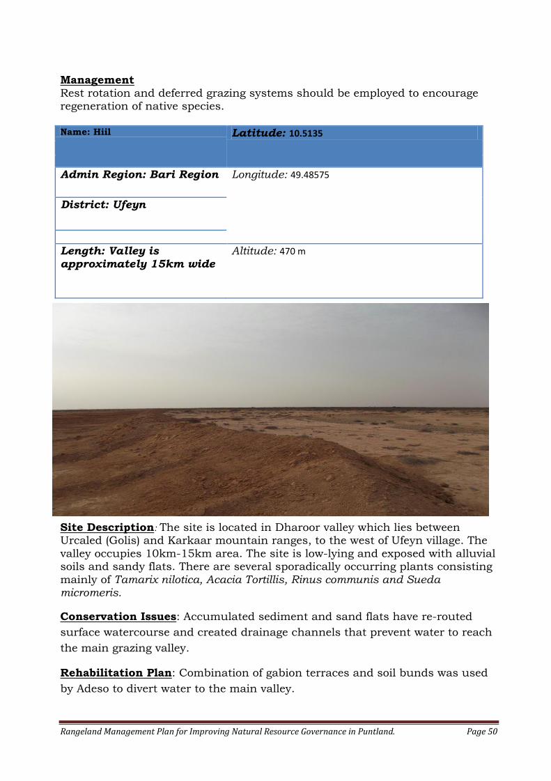
Rangeland Management Plan for Improving Natural Resource Governance in Puntland. Page 50
Management
Rest rotation and deferred grazing systems should be employed to encourage regeneration of native species. Name: Hiil Latitude: 10.5135
Admin Region: Bari Region Longitude: 49.48575
District: Ufeyn
Length: Valley is approximately 15km wide
Altitude: 470 m
Site Description: The site is located in Dharoor valley which lies between Urcaled (Golis) and Karkaar mountain ranges, to the west of Ufeyn village. The
valley occupies 10km-15km area. The site is low-lying and exposed with alluvial soils and sandy flats. There are several sporadically occurring plants consisting
mainly of Tamarix nilotica, Acacia Tortillis, Rinus communis and Sueda micromeris.
Conservation Issues: Accumulated sediment and sand flats have re-routed
surface watercourse and created drainage channels that prevent water to reach
the main grazing valley.
Rehabilitation Plan: Combination of gabion terraces and soil bunds was used
by Adeso to divert water to the main valley.

Rangeland Management Plan for Improving Natural Resource Governance in Puntland. Page 51
Management: Deferred grazing system is recommended to encourage vegetation
growth and to allow native plants to set seed for future regeneration. Name: Dhaadaar Latitude: 11.12581
Admin Region: Bari Region Longitude: 49.87221
District: Balidhidin
Dimension: 400m long x70m wide and 7m deep
Altitude: 1418m
Site Description: Dhaadaar gully is located on the outskirt of Dhaadaar village
in Balidhidin district of Bari region. The site is situated in a valley surrounded by mountains reaching 1418m above the sea level. The gully is advancing towards the Dhaadaar village and it is wasting away an important grazing valley
that supports large pastoral community. There are several sporadically occurring plants consisting mainly of Acacia Tortillis, Acacia bussei, Boscia minimifolia, Andropogon kelleri and Crysopogon aucheri. The gully exposes a soil profile comprising a solid layer of soft alluvial soils.
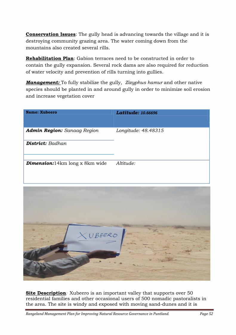
Rangeland Management Plan for Improving Natural Resource Governance in Puntland. Page 52
Conservation Issues: The gully head is advancing towards the village and it is
destroying community grazing area. The water coming down from the
mountains also created several rills.
Rehabilitation Plan: Gabion terraces need to be constructed in order to
contain the gully expansion. Several rock dams are also required for reduction
of water velocity and prevention of rills turning into gullies.
Management: To fully stabilize the gully, Zizyphus hamur and other native
species should be planted in and around gully in order to minimize soil erosion
and increase vegetation cover
Name: Xubeero Latitude: 10.66696
Admin Region: Sanaag Region Longitude: 48.48315
District: Badhan
Dimension:14km long x 8km wide Altitude:
Site Description: Xubeero is an important valley that supports over 50 residential families and other occasional users of 500 nomadic pastoralists in the area. The site is windy and exposed with moving sand-dunes and it is

Rangeland Management Plan for Improving Natural Resource Governance in Puntland. Page 53
located about 18km outside of Badhan town. There is little vegetation left in the
valley with occasional plants of Tamarix nilotica and Acacia Tortillis found on the banks of a watercourse situated on the edge of the valley.
Conservation Issues: The surface flood-water has not been reaching the main
valley during past several years. The water-course has been diverted by a build
up of sediment from the watercourse and the moving dunes from the valley
itself.
Photo: Watercourse on the edge of the valley diverted flood water away from the main valley.
Rehabilitation Plan: Combination of gabion terrace structures and diversion
ditches are needed for re-routing water into the main valley.
Management: Full recovery of the valley will take several years and thus support of the community and local police will be needed for keeping the
livestock out from the valley until vegetation cover returns. Rotational and deferred grazing systems should be maintained afterwards. Name: Habarshire Latitude:
Admin Region: Sanaag Longitude:
District: Badhan
Dimension: 7km long x60m wide and 6m deep
Altitude:
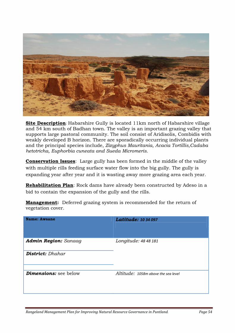
Rangeland Management Plan for Improving Natural Resource Governance in Puntland. Page 54
Site Description: Habarshire Gully is located 11km north of Habarshire village
and 54 km south of Badhan town. The valley is an important grazing valley that supports large pastoral community. The soil consist of Aridisolis, Combidis with
weakly developed B horizon. There are sporadically occurring individual plants and the principal species include, Zizyphus Mauritania, Acacia Tortillis,Cadaba hetotricha, Euphorbia cuneata and Sueda Micromeris.
Conservation Issues: Large gully has been formed in the middle of the valley
with multiple rills feeding surface water flow into the big gully. The gully is
expanding year after year and it is wasting away more grazing area each year.
Rehabilitation Plan: Rock dams have already been constructed by Adeso in a
bid to contain the expansion of the gully and the rills.
Management: Deferred grazing system is recommended for the return of vegetation cover. Name: Awsane Latitude: 10 34 097
Admin Region: Sanaag Longitude: 48 48 181
District: Dhahar
Dimensions: see below Altitude: 1058m above the sea level
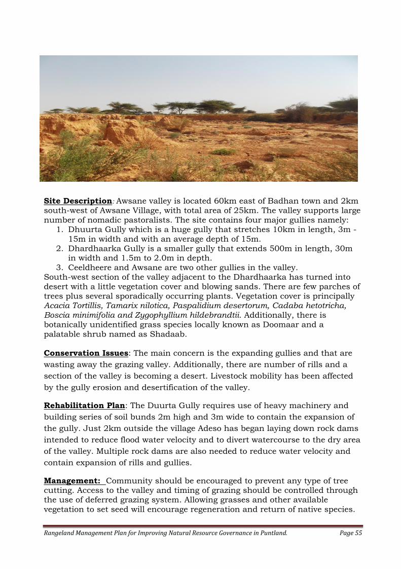
Rangeland Management Plan for Improving Natural Resource Governance in Puntland. Page 55
Site Description: Awsane valley is located 60km east of Badhan town and 2km south-west of Awsane Village, with total area of 25km. The valley supports large
number of nomadic pastoralists. The site contains four major gullies namely: 1. Dhuurta Gully which is a huge gully that stretches 10km in length, 3m -
15m in width and with an average depth of 15m. 2. Dhardhaarka Gully is a smaller gully that extends 500m in length, 30m
in width and 1.5m to 2.0m in depth.
3. Ceeldheere and Awsane are two other gullies in the valley. South-west section of the valley adjacent to the Dhardhaarka has turned into
desert with a little vegetation cover and blowing sands. There are few parches of trees plus several sporadically occurring plants. Vegetation cover is principally Acacia Tortillis, Tamarix nilotica, Paspalidium desertorum, Cadaba hetotricha, Boscia minimifolia and Zygophyllium hildebrandtii. Additionally, there is botanically unidentified grass species locally known as Doomaar and a
palatable shrub named as Shadaab. Conservation Issues: The main concern is the expanding gullies and that are
wasting away the grazing valley. Additionally, there are number of rills and a
section of the valley is becoming a desert. Livestock mobility has been affected
by the gully erosion and desertification of the valley.
Rehabilitation Plan: The Duurta Gully requires use of heavy machinery and
building series of soil bunds 2m high and 3m wide to contain the expansion of
the gully. Just 2km outside the village Adeso has began laying down rock dams
intended to reduce flood water velocity and to divert watercourse to the dry area
of the valley. Multiple rock dams are also needed to reduce water velocity and
contain expansion of rills and gullies.
Management: Community should be encouraged to prevent any type of tree cutting. Access to the valley and timing of grazing should be controlled through the use of deferred grazing system. Allowing grasses and other available
vegetation to set seed will encourage regeneration and return of native species.
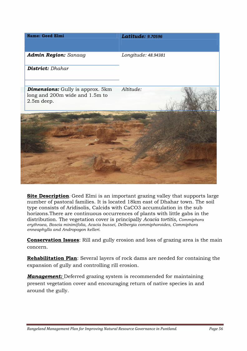
Rangeland Management Plan for Improving Natural Resource Governance in Puntland. Page 56
Name: Geed Elmi Latitude: 9.70596
Admin Region: Sanaag Longitude: 48.94381
District: Dhahar
Dimensions: Gully is approx. 5km
long and 200m wide and 1.5m to 2.5m deep.
Altitude:
Site Description: Geed Elmi is an important grazing valley that supports large
number of pastoral families. It is located 18km east of Dhahar town. The soil type consists of Aridisolis, Calcids with CaCO3 accumulation in the sub
horizons.There are continuous occurrences of plants with little gabs in the distribution. The vegetation cover is principally Acacia tortitis, Commiphora
erythraea, Boscia minimifolia, Acacia bussei, Delbergia commiphoroides, Commiphora enneaphylla and Andropogon kelleri.
Conservation Issues: Rill and gully erosion and loss of grazing area is the main
concern.
Rehabilitation Plan: Several layers of rock dams are needed for containing the
expansion of gully and controlling rill erosion.
Management: Deferred grazing system is recommended for maintaining
present vegetation cover and encouraging return of native species in and
around the gully.
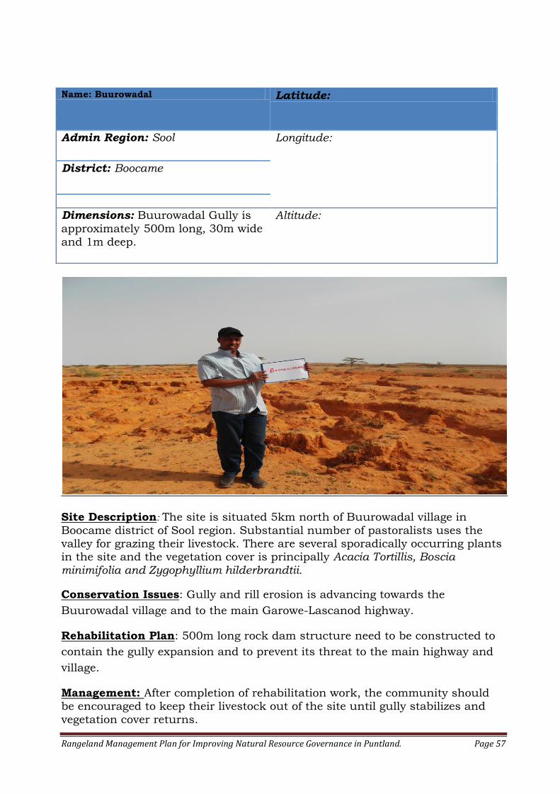
Rangeland Management Plan for Improving Natural Resource Governance in Puntland. Page 57
Name: Buurowadal Latitude:
Admin Region: Sool Longitude:
District: Boocame
Dimensions: Buurowadal Gully is
approximately 500m long, 30m wide
and 1m deep.
Altitude:
Site Description: The site is situated 5km north of Buurowadal village in
Boocame district of Sool region. Substantial number of pastoralists uses the valley for grazing their livestock. There are several sporadically occurring plants in the site and the vegetation cover is principally Acacia Tortillis, Boscia minimifolia and Zygophyllium hilderbrandtii.
Conservation Issues: Gully and rill erosion is advancing towards the
Buurowadal village and to the main Garowe-Lascanod highway.
Rehabilitation Plan: 500m long rock dam structure need to be constructed to
contain the gully expansion and to prevent its threat to the main highway and
village.
Management: After completion of rehabilitation work, the community should be encouraged to keep their livestock out of the site until gully stabilizes and
vegetation cover returns.

Rangeland Management Plan for Improving Natural Resource Governance in Puntland. Page 58
Name: Xayrobaxsho Latitude: 8.3579
Admin Region: Sool Longitude: 47.94498333
District: Boocame
Length: Altitude: 612 M
Site Description: The site is located 5km south east of Boocame town.
Xayrabaxsho is a farming community consisting mainly of vegetable growers.
There are continuous uniform occurrences of well spaced plants consisting
mainly of Acacia Tortillis, Commiphora erythraea, Acacia mellifera, Acacia
senegal, Euphorbia cuneata, Rinus communis, Terminalia orbicularis and
Commiphora rostrata. The gully on the edge of the farms reveals a soil profile
consisting of deposits of red alluvial soils.
Conservation Issues: Natural channel or dry-river near the farms produced
tributaries that regularly flood towards the farmland. The site shows failed
gabion terrace structures that was previously build by another aid organization.

Rangeland Management Plan for Improving Natural Resource Governance in Puntland. Page 59
Rehabilitation Plan: Repairing stone displacement and structural failure of
gabion terrace structure is recommended. The structure should be well keyed
into the banks of the gully. Several rock check dams are being constructed by
Adeso to reduce velocity of surface floodwater, to protect the farmland and
increase percolation of water into the soil.
Management: Regular monitoring for structural failure is recommended.
Name: Waydallo Latitude: 8.194016667
Admin Region: Sool Longitude: 47.76153333
District: Boocame
Dimensions: 1km in length and
300m in width.
Altitude: 760m
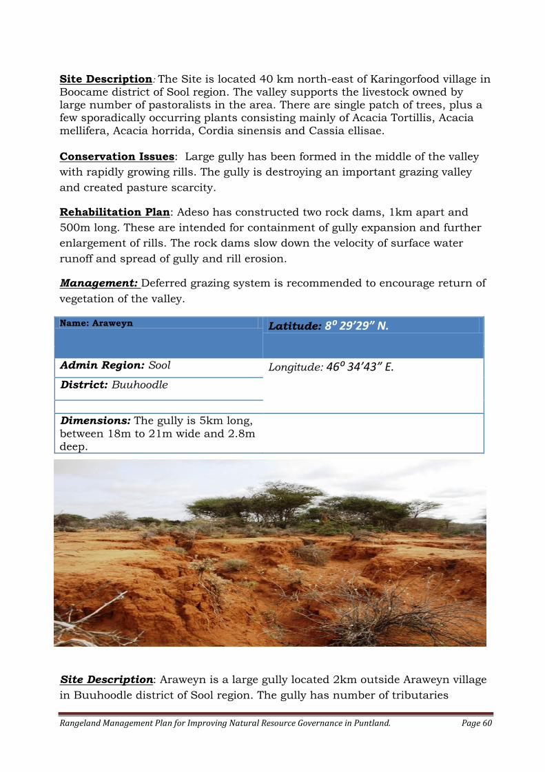
Rangeland Management Plan for Improving Natural Resource Governance in Puntland. Page 60
Site Description: The Site is located 40 km north-east of Karingorfood village in
Boocame district of Sool region. The valley supports the livestock owned by large number of pastoralists in the area. There are single patch of trees, plus a few sporadically occurring plants consisting mainly of Acacia Tortillis, Acacia
mellifera, Acacia horrida, Cordia sinensis and Cassia ellisae.
Conservation Issues: Large gully has been formed in the middle of the valley
with rapidly growing rills. The gully is destroying an important grazing valley
and created pasture scarcity.
Rehabilitation Plan: Adeso has constructed two rock dams, 1km apart and
500m long. These are intended for containment of gully expansion and further
enlargement of rills. The rock dams slow down the velocity of surface water
runoff and spread of gully and rill erosion.
Management: Deferred grazing system is recommended to encourage return of
vegetation of the valley.
Name: Araweyn Latitude: 8: 29’29” N.
Admin Region: Sool Longitude: 46⁰ 34’43” E.
District: Buuhoodle
Dimensions: The gully is 5km long,
between 18m to 21m wide and 2.8m deep.
Site Description: Araweyn is a large gully located 2km outside Araweyn village
in Buuhoodle district of Sool region. The gully has number of tributaries
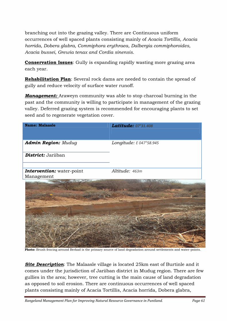
Rangeland Management Plan for Improving Natural Resource Governance in Puntland. Page 61
branching out into the grazing valley. There are Continuous uniform
occurrences of well spaced plants consisting mainly of Acacia Tortillis, Acacia
horrida, Dobera glabra, Commiphora erythraea, Dalbergia commiphoroides,
Acacia bussei, Grewia tenax and Cordia sinensis.
Conservation Issues: Gully is expanding rapidly wasting more grazing area
each year.
Rehabilitation Plan: Several rock dams are needed to contain the spread of
gully and reduce velocity of surface water runoff.
Management: Araweyn community was able to stop charcoal burning in the
past and the community is willing to participate in management of the grazing
valley. Deferred grazing system is recommended for encouraging plants to set
seed and to regenerate vegetation cover.
Name: Malaasle Latitude: 07°31.408
Admin Region: Mudug Longitude: E 047°58.945
District: Jariiban
Intervention: water-point
Management
Altitude: 463m
Photo: Brush fencing around Berkad is the primary source of land degradation around settlements and water-points.
Site Description: The Malaasle village is located 25km east of Burtinle and it
comes under the jurisdiction of Jariiban district in Mudug region. There are few
gullies in the area; however, tree cutting is the main cause of land degradation
as opposed to soil erosion. There are continuous occurrences of well spaced
plants consisting mainly of Acacia Tortillis, Acacia horrida, Dobera glabra,
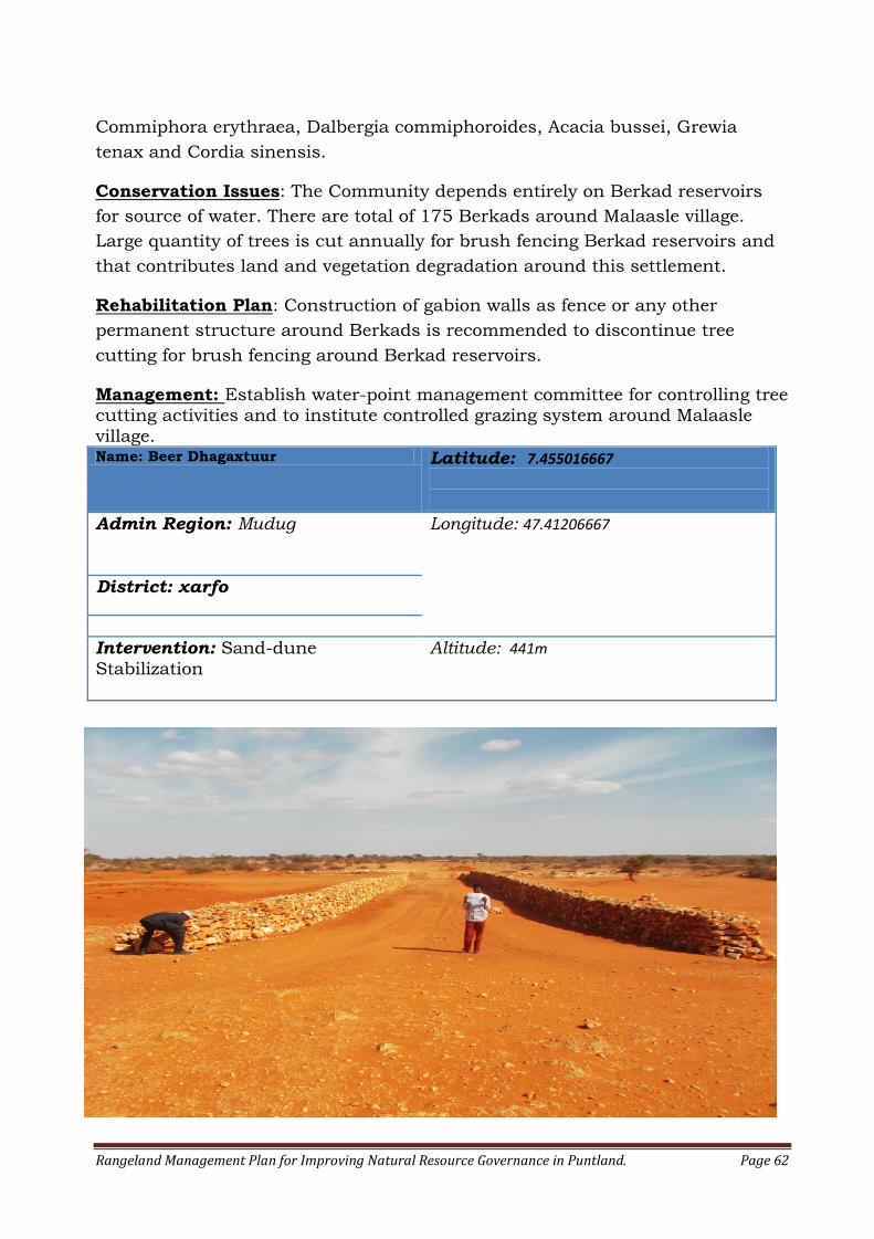
Rangeland Management Plan for Improving Natural Resource Governance in Puntland. Page 62
Commiphora erythraea, Dalbergia commiphoroides, Acacia bussei, Grewia
tenax and Cordia sinensis.
Conservation Issues: The Community depends entirely on Berkad reservoirs
for source of water. There are total of 175 Berkads around Malaasle village.
Large quantity of trees is cut annually for brush fencing Berkad reservoirs and
that contributes land and vegetation degradation around this settlement.
Rehabilitation Plan: Construction of gabion walls as fence or any other
permanent structure around Berkads is recommended to discontinue tree
cutting for brush fencing around Berkad reservoirs.
Management: Establish water-point management committee for controlling tree cutting activities and to institute controlled grazing system around Malaasle
village. Name: Beer Dhagaxtuur Latitude: 7.455016667
Admin Region: Mudug Longitude: 47.41206667
District: xarfo
Intervention: Sand-dune
Stabilization
Altitude: 441m
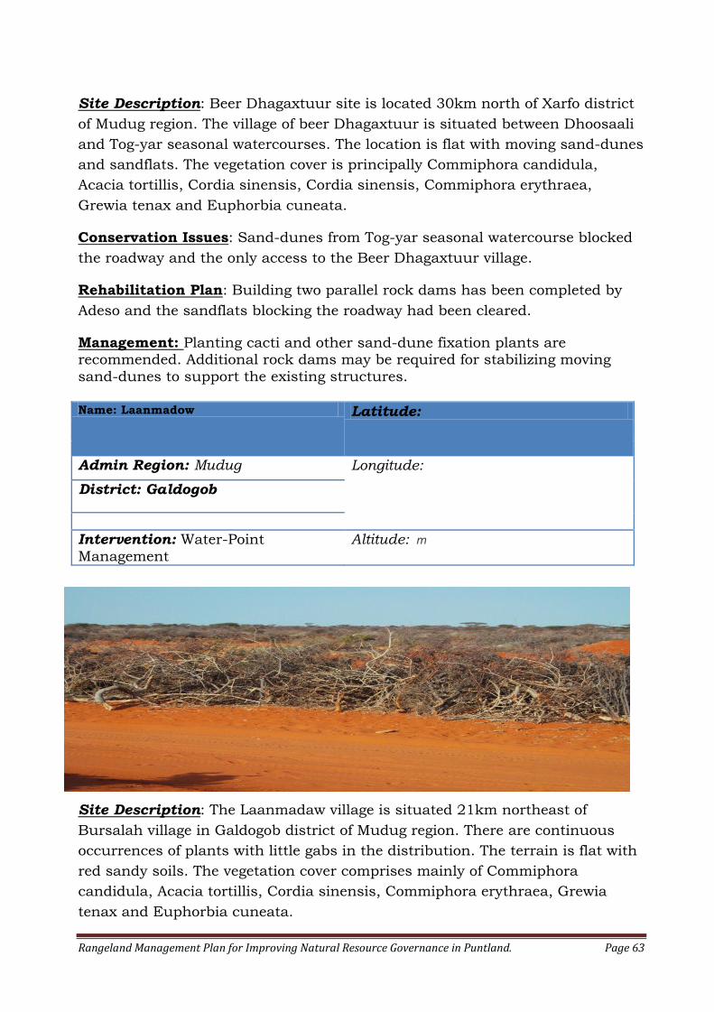
Rangeland Management Plan for Improving Natural Resource Governance in Puntland. Page 63
Site Description: Beer Dhagaxtuur site is located 30km north of Xarfo district
of Mudug region. The village of beer Dhagaxtuur is situated between Dhoosaali
and Tog-yar seasonal watercourses. The location is flat with moving sand-dunes
and sandflats. The vegetation cover is principally Commiphora candidula,
Acacia tortillis, Cordia sinensis, Cordia sinensis, Commiphora erythraea,
Grewia tenax and Euphorbia cuneata.
Conservation Issues: Sand-dunes from Tog-yar seasonal watercourse blocked
the roadway and the only access to the Beer Dhagaxtuur village.
Rehabilitation Plan: Building two parallel rock dams has been completed by
Adeso and the sandflats blocking the roadway had been cleared.
Management: Planting cacti and other sand-dune fixation plants are recommended. Additional rock dams may be required for stabilizing moving
sand-dunes to support the existing structures. Name: Laanmadow Latitude:
Admin Region: Mudug Longitude:
District: Galdogob
Intervention: Water-Point
Management
Altitude: m
Site Description: The Laanmadaw village is situated 21km northeast of
Bursalah village in Galdogob district of Mudug region. There are continuous
occurrences of plants with little gabs in the distribution. The terrain is flat with
red sandy soils. The vegetation cover comprises mainly of Commiphora
candidula, Acacia tortillis, Cordia sinensis, Commiphora erythraea, Grewia
tenax and Euphorbia cuneata.
Rangeland Management Plan for Improving Natural Resource Governance in Puntland. Page 64
Conservation Issues: The Laanmadow community depends entirely on Berkad
reservoirs for source of fresh water. The increase of Berkads and tree cutting for
brush fencing them is considered as primary source of land degradation and
depletion of vegetation. There over 70 Berkads privately owned Berkads around
the village.
Rehabilitation Plan: Building permanent structures such as gabion walls or
any other permanent structures around Berkads is recommended to stop tree
cutting for brush fencing berkads.
Management: Establishment of water-point management committee is recommended for controlling tree cutting activities in the community and to
encourage community land stewardship.
Annex II: SURVEY QUESTIONNAIRE
A. Stakeholder Question 1: Are you currently employed in the:
Public sector Private sector
Pastoral sector Other Stakeholder:
Name: ____________________________ Name of Institution: __________________ Title: ______________________________
B. Stakeholder Perception on Land Degradation Question 1: Is rangeland degradation in Puntland real or is it a perceived notion?
Real Perceived Don’t Know
Question 2: Do you consider land degradation in Puntland as: Moderate to Extreme Slight to Moderate
None to slight Question 3: What are the root causes of Land Degradation?
Climate Change Human Activity
Combination of above Question 4: What Climatic Changes have you observed in the recent past? Comments: Question 5: What human activities are causing land degradation in Puntland? List:
1: 2: 3: 4:
5:
Rangeland Management Plan for Improving Natural Resource Governance in Puntland. Page 65
Question 6: Do know of any plant Species that are declining in Puntland? Name them: Reasons for decline: Question 7: Do know of any plant Species that are increasing in numbers in Puntland? Name them: Reasons for increase:
C. Stewardship Perception Question 1: Do you agree or disagree that the land in Puntland should be passed on to the next generation in at least as good a condition as it was received from previous generations?
Agree Disagree
Explain: Question 2: Who should be responsible for managing rangelands in your community?
Ministry of Environment only Local Community only
A Community Appointed Management body A Joint Government-Community-appointed body Others: ____________________________
Question 3: What steps should be taken to protect the Environment from misuse at local level?
Recognition of customary laws in courts
More Government support and presence More local community participation
Land Tenure change from State to Customary
Appendix III: List of all Sites selected for rehabilitation
No Region District Location Name Elevation Latitude Longitude
1 Bari Kobdhexad Village Kobdhexad 1 505m 10.65455 49.50555
2 Bari Kobdhexad Village Kobdhexad 2 496m 10.63045 49.54961667
3 Bari Kobdhexad Village Hiil 470m 10.5135 49.48575
4 Bari Kobdhexad Village Ceel Dheero 1 444m 10.43551667 49.5657
5 Bari Kobdhexad Village Ceel Dheero 2 438m 10.44505 49.55593333
6 Bari Kobdhexad Village Gumbule 450m 10.42031667 49.5275
7 Bari Dharoor Keli 320m 10.33996667 49.92873333
8 Bari Dharoor God Dhurwa 366m 10.40975 49.84778333
9 Bari Dharoor Hariso 1 386m 10.45188333 49.80368333
10 Bari Dharoor Hariso 2 386m 10.45251667 49.8038
11 Bari Dharoor Jab Goble 402m 10.43881667 49.77725
12 Bari Dharoor Dabar 1 408m 10.35718333 49.71488333
13 Bari Dharoor Dabar 2 405m 10.34626667 49.70883333
14 Bari Dharoor Kala jabka Dabar 394m 10.31965 49.68508333
15 Bari Dharoor Dharer Gaal 376m 10.42606667 49.85116667
16 Bari Xiriiro Village Biki Xiriirod 415m 10.11031667 50.28036667
17 Bari Xiriiro Village Sarman Xiriirod 496m 10.0287 50.31053333
Rangeland Management Plan for Improving Natural Resource Governance in Puntland. Page 66
18 Bari Xiriiro Village Caleemaley 1 479m 9.865466667 50.34788333
19 Bari Xiriiro Village Caleemaley 2 483m 9.866566667 50.3448
20 Bari Xiriiro Village Kobdhexad Xirirod 414m 9.874316667 50.42838333
21 Bari Balidhidin Village Balidhidin 565m 10.88026667 50.39421667
22 Bari Balidhidin Village Hagoogan 542m 10.90166667 50.41288333
23 Bari Xubabays Village Xubabays 434m 10.02358333 50.45238333
24 Bari Taageer village Haraba 1 112m 10.88885 50.876
25 Bari Taageer village Haraba 2 126m 10.8872 50.87363333
26 Bari Taageer village Dara Gaab 1 101m 10.9551 50.91728333
27 Bari Taageer village dara Gaab 2 116m 10.95063333 50.9199
28 Bari Ceel Daahir Qalqo Jimbac 647m 10.65495 49.04626667
29 Bari Ceel Daahir Bilcil waydle 645m 10.6786 49.03526667
30 Bari Bargal District Xinka 1m 11.19178333 51.04738333
31 Bari Bargal District Bargal 46m 11.28613333 50.07778333
32 Bari Bargal District bargal Stream 6m 11.28333333 51.07338333
33 Bari Lasa dawaco Village Higlo Gaab 654m 10.46961667 49.09193333
34 Bari Tuur masaale Tuur masaale 855m 10.93055 50.22946
35 Bari Dhaadar Dhaadar 1418m 11.12581 49.87221
36 Bari Ufayn Ufayn 472m 10.38963 49.45816
37 Bari Bilcilka Bilcilka 458m 10.37156 49.4662
38 Bari Kalajabka Bilcilka Kalajabka Bilcilka 461m 10.38554 49.46981
39 Bari Jiid madow 1 Jiid madow 1 472m 10.35662 49.42577
40 Bari Jiid madow 2 Jiid madow 2 475m 10.35635 49.42577
41 Bari Camman Camman 428m 10.11419 49.50625
42 Bari Camman Kalajabka Camman Kalajabka 402m 10.09893 49.49231
43 Bari Camman Gulley Camman Gulley 453m 10.10057 49.50182
44 Mudug Galkayo Galkayo 289m N 06°47.063 E 047°25.093
45 Mudug Galkayo Beyra 322m N 06°57.048 E 047°19.069
46 Mudug Galkayo Cagaraan 355m N 07°05.706 E 047°29.936
47 Mudug Galkayo Heema 366m N 07°11.387 E 047°31.513
48 Mudug Galkayo Hadoodil 1474m N 06°47.960 E 047°25.378
49 Mudug Galkayo Roox 378m N 07°12.218 E 047°25.987
50 Mudug Galkayo Bacadweyn 389m N 07°15.565 E 047°33.947
51 Mudug Galkayo Tuulo Habibo 422m N 07°21.183 E 047°24.578
52 Mudug Galkayo Harfo 405m N 07°20.820 E 047°37.084
53 Mudug Galkayo Beer Dhahtuur 441m 7.455016667 47.41206667
54 Mudug Galkayo Bilcil 467m N 07°27.378 E 047°43.396
55 Mudug Galkayo Gosol 417m N 07°26.728 E 047°52.100
56 Mudug Jariban Malaasle 463m N 07°31.408 E 047°58.945
57 Mudug Jariban Qalaanqal 459m N 07°28.498 E 048°03.608
58 Mudug Jariban Balanbal 442m N 07°26.852 E 048°08.546
59 Mudug Jariban Buubi 252m N 07°08.512 E 048°23.035
Rangeland Management Plan for Improving Natural Resource Governance in Puntland. Page 67
60 Mudug Jariban Sallax 325m N 07°17.797 E 048°19.402
61 Mudug Jariban Seemade 204m N 07°09.324 E 048°36.593
62 Mudug Jariban Booc 224m N 07°15.527 E 048°43.740
63 Mudug Jariban Jariban 186m N 07°12.806 E 048°51.042
64 Mudug Jariban Mareer 93m N 07°02.708 E 049°04.775
65 Mudug Jariban Dhinowda 18m N 06°43.812 E 049°12.140
66 Mudug Jariban Garacad 5m N 06°56.601 E 049°19.137
67 Mudug Galdogob Xerojaale 356m N 06°59.123 E 047°11.402
68 Mudug Galdogob Galdogob 379m N 07°01.831 E 047°01.201
69 Mudug Galdogob Qansaxle 394m N 07°06.852 E 047°05.749
70 Mudug Galdogob Riigoomane 395m N 07°12.376 E 047°11.586
71 Mudug Galdogob Darusalaam 411m N 07°15.558 E 047°06.471
72 Mudug Galdogob Bursaalax 398m N 07°10.469 E 047°14.583
73 Mudug Galdogob Laanmadow 417m N 07°19.787 E 047°17.440
74 Sanaag Yubbe Wadaayin 10.67475 47.95557
75 Sanaag Hadaftimo Dagar 10.7994 48.07047
76 Sanaag Dagar Billal lagu gud 10.83155 48.02837
77 Sanaag Hadaftimo Hadaftimo Gully 10.77388 48.09592
78 Sanaag Mindigale Argeegta 10.68674 48.68679
79 Sanaag Mindigale Dawliga Yar 10.66619 48.66567
80 Sanaag Mindigale Qoolo 10.6935 48.64128
81 Sanaag Rad qomornaylood 10.72961 48.56121
82 Sanaag Rad Laako 10.72256 48.41886
83 Sanaag Ceelbuh Jiianyo 1105 10.23204 48.22 801
84 Sanaag
Ceelbuh Ceelbuh stream delta
10.22565 48.31252
85 Sanaag Kaladhac Kateen xuunsho 10.04184 48.84325
86 Sanaag Dhahar Geedcilmi 9.70596 48.94381
87 Sanaag Dhahar Dhahar valley 9.74642 48.82157
88 Sanaag Badhan shimis 10.6638 48.41886
89 Sanaag Dhahar Awsane gully 1058 10 34 097 48 48 181
90 Sanaag Badhan Arowayn 1223 10 47 289 48 13 600
91 Sanaag Badhan Dagar/Qorisarmale 1,376 10 49 364 48 01 801
92 Sanaag Badhan Boholwaafle 1452 10 47 280 48 02 751
93 Sanaag Badhan Huddhabijo 1464 10 45 613 48 02237
94 Sanaag Badhan Qarqoora 1389 10 36 339 48 02 328
95 Sanaag Badhan Urur 1063 10 21 849 48 24 015
96 Sanaag Badhan Habarhunbule 1056 10 29 898 48 24 933
97 Sanaag Badhan Damal buul 1066 10 34 212 48 23 187
98 Sanaag Badhan Looxanyo 993 10 35 976 48 24 990
99 Sanaag Badhan Durduri 12 17 846 48 35 156
100 Sanaag Badhan Damceiyo (dameer) 930 10 32 747 48 32 954
101 Sanaag Badhan Xubeera 10.66696 48.48315
Rangeland Management Plan for Improving Natural Resource Governance in Puntland. Page 68
102 Sanaag Hingalool Sinkholes
103 Sool Boocame Bo’came 598m 8.396983333 47.93755
104 Sool Boocame Karin-Garfood 728m 8.121516667 47.7565
105 Sool Boocame Waydalo 760m 8.194016667 47.76153333
106 Sool Boocame Xayrobaxsho 612m 8.3579 47.94498333
107 Sool Boocame Buulal 777m 8.225383333 47.81271667
108 Sool Buhodle Faarax bulay Gully 645m 8.248683333 46.36153333
109 Sool Buhodle Shangale Gully 419m 8.2703 46.32151667
110 Sool Buhodle Cumar aji Gully 674m 8.325366667 46.31638333
111 Sool Buhodle Sool joogto Gully 713m 8.426933333 46.31981667
112 Sool Maygagle 734m 8.45345
46.30956667
113 Sool Buhodle Dudumo 764m 8.452283333 46.45453333
114 Sool Buhodle Laaso Dabatag 745M 8.445916667 46.48393333
115 Sool Dhilaalo Wadada Dhilaalo 691m 8.33155 46.36226667
116 Sool Xudun Xudun Valley 661m 9.189916667 47.46428333
117 Sool Xudun Jidhaan- Dhiig 638m 9.126683333 47.59563333
118 Sool Xudun Shimbiraaleey 583m 9.038916667 47.4925
Appendix IV: Vegetation Density Distribution Guide
DESCRIPTION OF VEGETATION COVER DISTRIBUTION
None
Rare
Few sporadically occurring individual plants
A single patch
A single patch plus a few sporadically occurring
plants
Several sporadically occurring plants
A single patch plus several sporadically occurring
plants
Rangeland Management Plan for Improving Natural Resource Governance in Puntland. Page 69
A few patches
A few patches plus several sporadically occurring
plants
Several well spaced patches
Continuous uniform occurrences of well spaced
plants
Continuous occurrence of plants with a few gaps
in the distribution
Continuous dense occurrence of plants
Continuous occurrence of plants with a distinct
linear edge in the polygon
Source: Government of Alberta (2011).
Annex V: Sample Size determination Guide
Source: Survey monkey (www.surveymonkey.com)
Rangeland Management Plan for Improving Natural Resource Governance in Puntland. Page 70
10: Reference
1. Aronson, D. (1979). Somalia-Agriculture Sector Review: The Social Impact of
Agricultural Development. African Studies Center, Boston University, for USAID.
2. Bare, M.H (2009).Puntland Rangeland Management Policy Document. Diaspora Partnership Program CARE Netherlands, Garowe, Puntland State of Somalia.
3. Boaler, S.B. and Hodge, C.A.H. (1962). Observation on Vegetation arcs in the northern regions, British Somaliland. Journal of Ecology,52 511-544.
4. Bravo, G.A. (1938). Some plants suitable for tanning from Italian Somalia and Jubbaland.Bolletino dell’ Associazione italiana di Chemica e Tecnica Conciaria,7.
5. Chevalier, A. (1939). The flora and vegetable production. Revue Internationale Botanique Applique,e et Agriculture Tropicale,19,663-687.
6. Chiovenda, E. (1916).The Scientific results of the Stefanini-Paoli Mission to Italian Somalia. The botanical collection. Regio Instituto Studi Superiori di Firenze, Firenze, Italy.
7. Drake-Brockman. R.E. (1912). British Somaliland. Hurst and Blackett, London, UK.
8. FAO. (1972).Survey of northern rangelands. Somali democratic republic ecological and grazing survey of the Mudug Region. Based on the work of C.F. Hemming. UNDP/FAO/SF: SOM/70/512. FAO, Rome, Italy.
9. FAO. (1987). Soil and water Conservation in north east Somalia. Prepared by
D. Layzell and A.D. McKay.TCP/SOM/6654. FAO, Rome, Italy.28 pp.
10. Gilliland, H.B. (1952). The Vegetation of Eastern British Somaliland. Journal of ecology, 40, 91-124.
11. Glover, P.E. (1947). British and Italian Somaliland. Volume 1. A provisional checklist of British and Italian Somaliland trees, shrubs and herbs (including the reserved area adjacent to Abyssinia). Crown Agents, London, UK.
12. Griffiths, M.E. (1959). A review of African Species of Terminalia. Journal of the Linnean Society, London, 55,818-907.
13. Government of Alberta (2011).Range Health Assessment, field worksheets for Forests. Government of Alberta, Edmonton, Alberta, Canada.
14. Guerin LJ and Guerin TF, 1994, Constraints to the adoption of innovations in agricultural research and environmental management: a review‘, Australian Journal of Experimental Agriculture, 34: 549-571.

Rangeland Management Plan for Improving Natural Resource Governance in Puntland. Page 71
15. Guyo, M.R, et al (2013). Natural Resources Management Baseline Survey Report for Puntland. African Development Solutions and Care International, Garowe, Puntland State of Somalia.
16. Hardin, Garrett (1968).the Tragedy of the Commons. Science, Vol. 162, pp.
1243-1248.
17. Hemming, C.F. (1966). The vegetation of the northern region of the Somali Republic. Proceedings of the Linnean Society, London, 177,173-250.
18. Hunt, J.A. (1951). A general Survey of Somaliland Protectorate 1944-1950. Final report on ‘an economic survey and reconnaissance of the British Somaliland Protectorate 1944-1950; Colonial development and Welfare scheme D484. Crown Agents for the Colonies, London, UK.203 pp.
19. Jama, A.I. (2011), Draft Environmental Policy for Puntland. Quest-MIDA Project, Garowe, Puntland State of Somalia.
20. Kempthorne, G.B (1844). Narrative of Hasty trip to the frankincense country.
Transactions of the Bombay Geographic Society, 4,410-414.
21. Lawrie, J.J. (1954). Acacia and the Somali. Empire Forestry review,33,234-238.
22. Macfadyen, W.A. (1950). Soil and vegetation in British Somaliland. Nature, 165, p.121.
23. Ministry of Planning and Statistics (2003). Puntland Facts and Figures.
Garowe, Puntland State of Somalia.
24. Neugebaur, S., Getachew Gebru, Peacock, C.P., 1991. Estimation of goat milk yield from kid growth performance. In: Proc. IV National Livestock Improvement Conference, 11-13 November, 1991, Addis Ababa, Ethiopia.
25. NRA (1988). National Plan of Action to Combat Desertification in Somalia.
National Range Agency, Mogadishu, Somalia.
26. Nur, Y. And Fardhis, S. (2013). Natural Resource Management Customary Law. Ministry of Environment, Wildlife and Tourism, Garowe, Puntland State of Somalia.
27. Panjabi, R.K.(210). The Pirates of Somalia: Opportunistic Predators or Environmental Prey? 34 Wm. & Mary Envtl. L. & Pol'y Rev. 377
28. Petersen G. Gadain HM. 2012. Climate Change Impacts on Water Resources of Somaliland and Puntland. Technical Report No W-21, FAO-SWALIM, Nairobi, Kenya.
Rangeland Management Plan for Improving Natural Resource Governance in Puntland. Page 72
29. UNEP (2005). The State of Environment in Somalia- A Desk Study. United Nations Environmental Programme. Nairobi, Kenya.
30. Unruh JD (1995) Pastoralist resource use and access in Somalia: a changing
context of development, environmental stress, and conflict. In: Sorenson J (ed.) Disaster and Development on the Horn of Africa. Macmillan, London.
31. Vanclay F and Lawrence G 1995, the Environmental Imperative. Central Queensland University Press, Brisbane, Australia.
32. Yencken D and Wilkinson D 2000, Resetting the Compass: Australia’s Journey towards Sustainability, CSIRO,Melbourne, Australia.

Rangeland Management Plan for Improving Natural Resource Governance in Puntland. Page 73