Rail Station Fact Sheet Fair Park StationRail Station Fact Sheet – Fair Park Station Station...
6
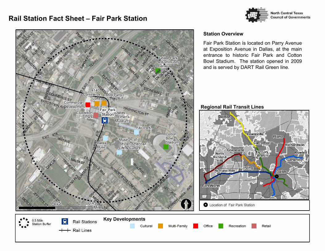
Station Overview Fair Park Station is located on Parry Avenue at Exposition Avenue in Dallas, at the main entrance to historic Fair Park and Cotton Bowl Stadium. The station opened in 2009 and is served by DART Rail Green line. Rail Station Fact Sheet – Fair Park Station Regional Rail Transit Lines
Transcript of Rail Station Fact Sheet Fair Park StationRail Station Fact Sheet – Fair Park Station Station...
Station Overview
Fair Park Station is located on Parry Avenue
at Exposition Avenue in Dallas, at the main
entrance to historic Fair Park and Cotton
Bowl Stadium. The station opened in 2009
and is served by DART Rail Green line.
Rail Station Fact Sheet – Fair Park Station
Regional Rail Transit Lines

Rail Station Fact Sheet – Fair Park Station
Station Characteristics1 Station Area Characteristics (1/2 mile radius)
Address 3710 Parry Avenue Demographics3
City Dallas Total Population 8,845
Agency Dallas Area Rapid Transit Population Density (pop/sq. mile) 2,092
Rail Line(s) Green Line Average Median Age 40
Corridor Southeast (SE) Average Median Income $35,928.78
Year Opened 2009
Park & Ride Spaces 0 Housing3
Total Housing Units 4,372
Ridership1 Housing Density (units/sq. mile) 1,034
2015 Avg. Weekday 950 Percent Occupied 83%
2015 Avg. Saturday 1,530 Percent Owner-Occupied 44%
2015 Avg. Sunday 1,048 Percent Renter-Occupied 56%
2014 On-Board Transit Survey: Access Mode to Station2 Commute To Work3
Bike 6.8% Percent Automobile 82.9%
Drive Alone 1.8% Percent Drive Alone 71.7%
Carpool 0.0% Percent Carpool 11.2%
Walk 61.5% Percent Transit 5.1%
Drop Off 10.2% Percent Bike 0.3%
Other 0.0% Percent Walk 4.6%
Transit Transfer 19.7% Percent Other 2.5%
Percent Work from Home 4.7%
Station Area Plans and Studies Percent Zero-Vehicle Households 15.5%
Title
Publisher Traffic Survey Zone 2017 Employment Forecast2
Year Total Jobs 8,378
Web Location Job Density (jobs/sq. mile) 4,949
Sources: 1. Dallas Area Rapid Transit (DART), 2. NCTCOG, 3. U.S. Census American Community Survey 5-year estimates (2010-2014) by block group

Land Use (2016) – Fair Park Station
Land Use Percentages

Zoning Districts
CH – Clustered Housing
CS – Commercial Service
D – Duplex
IM – Industrial Manufacturing
IR – Industrial Research
NS (A) – Neighborhood Service
MF-1 – Multi-family
MU-1 – Mixed-Use
P(A) – Parking
PD – Planned Development
WMU-5 – Walkable Mixed-Use
For more information on zoning, please visit the City of Dallas Zoning website at:
http://gis.dallascityhall.com/zoningweb/
Zoning (2016) – Fair Park Station

Fair ParkStation
MLK, Jr.Station
2ND
ELM
1ST
HASKELL
OAK
MAIN
HILL
PEAK
BANK
HASKELL
TRUNK
ANN
WASHINGTON
3RD
PHILIP
PENNSYLVANIA
WILLOW
CANTON
MERLIN
GURLEY
MEYERS
LINDSLEY
TERRY
JEFFRIES
HICKORY
MEADOW
CARROLL
MCKENZIE
LAGOW
STONEWALL
BAYLOR
RING
MEDILL
SIMPSON
RAINE
Y
BUTE
PARK ROW
WEST
FLETCHER
CRUTCHER
PARRY
CALDWELLCONGO
CHESTNUT
SANT
A FE
COMMERCE
MURRAY HAY
LOGAN
BENSO
N
MARTIN LUTHER KING JR
FERRIS
HALL
SAFETY
PAULINE ADAIR
GLEASON
HILL
FITZHUGH
SOUTH BLVD
BANK
GRAND
SANT
A FE
PARRY
3RD
MAIN
1ST
HALL
FLETCHERCOMMERCE
EXPOSITION
PARRY
ASH
MEYERS
CALDWELL
EXPOSITION
HASKELL
2ND
PHILIP
PEAKAS
H
GARLAND
2ND
FITZH
UGH
WILLOW
WASHINGTONCARROLL
ANN
J B Jackson Jr
ROBERT CULLUM BLVD
HICKORY
CALDWELL
BANK
GARLAND
HAMILTON
HILL
WORTH
BIRD
HASKELL
30
30 352
352
The Pedestrian Routes to Rail study identifies allexisting pedestrian facilities within a half-mile radiusof existing light rail and commuter rail stations in theDallas-Fort Worth region based on 2014 data.ArcGIS Network Analyst tool was used to identifycontinuous facilities that are less than or greaterthan a half-mile actual walking distance to a station.The maps also reflect existing facilities that aredisconnected due to gaps or other barriers notallowing a continuous pedestrian route to a station.The maps do not reflect the condition or ADAcompliance of the existing infrastructure. Moreinformation on the Routes to Rail study andmethodology is available at:
Project Overview
Pedestrian Routes to Rail - Fair Park Station
0 0.50.25Miles
LegendRail Stations
RailroadsExisting sidewalk facilities within a0.5 mile walk distanceExisting sidewalk facilities greater thana 0.5 mile walk distanceExisting sidewalk facilites that aredisconnected due to a gap in thenetwork
nctcog.org/RoutesToRail
0.5 Mile Station Buffer
Last Updated: February 2015

The Bicycle Routes to Rail study identifies allexisting and planned bikeways in proximity toexisting or under-construction light rail andcommuter rail stations in the Dallas / Fort Worthregion based on 2016 data. The maps reflectoff-street paths (trails) and streets designated bylocal adopted master plans for dedicatedbikeways (e.g. bike lanes, cycle tracks) locatedon the street. In accordance with the TexasTransportation Code, bicyclists have a right tothe road. As such, the map does not reflectother roadways around the station that may havesigned bike routes or by state law may be usedby bicyclists. More information about the Routesto Rail study and methodology is available at:
Project Overview
I2
I2
1ST AVE
HASKELL AVE
EXPOSITION AVEGRAND AVE
ELM ST
STONEWALL ST
PEAK ST
OAKLAND AVE
2ND AVE
MAIN ST
FITZHUGH AVEPA
RRY A
VE
ROBERT B CULLUM BLVD
ST352
[\̂30
Fair ParkStation
MLK, Jr.Station
[0 0.50.25Miles
I2 Rail Stations
Rail LinesOn-Street Bikeway, ExistingOn-Street Bikeway, Planned
2040 Veloweb
Off-Street Path, ExistingOff-Street Path, Planned
0.5 MileStation Buffer
Bicycle Routes to Rail - Fair Park StationLast Updated: October 2016
nctcog.org/RoutesToRail
Legend