Radiation measurements at ICOS ecosystem...
21
Radiation measurements at ICOS ecosystem stations Arnaud Carrara 1 *, Pasi Kolari 2 , Maarten Op de Beeck 3 , Nicola Arriga 3 , Daniel Berveiller 4 , Sigrid Dengel 5 , Andreas Ibrom 6 , Lutz Merbold 7,8 , Corinna Rebmann 9 , Simone Sabbatini 10 , Penelope Serrano-Ortíz 11 , and Sébastien C. Biraud 5 1 Mediterranean Center for Environmental Studies (CEAM), C/ Charles R. Darwin 14, Parque Tecnológico 46980, Paterna, Spain 2 Institute for Atmosphere and Earth System Research/ Physics, PO Box 68, Faculty of Science, University of Helsinki, Finland 3 Research Centre of Excellence Plants and Ecosystems (PLECO), University of Antwerp, Wilrijk, Belgium 4 Ecologie Systématique et Evolution, Univ. Paris-Sud, CNRS, AgroParisTech, Université Paris-Saclay, 91400 Orsay, France 5 Climate Sciences Department, Lawrence Berkeley National Laboratory, 1 Cyclotron Road, Berkeley, CA 94720, USA 6 Department of Environmental Engineering, Technical University of Denmark, Bygningstorvet, 2800 Kgs. Lyngby, Denmark 7 Institute of Agricultural Sciences, ETH Zurich, Universitätstrasse 2, 8092, Zurich, Switzerland 8 Mazingira Centre, International Livestock Research Institute (ILRI), P.O. Box 102 30709, 00100, Nairobi, 103 Kenya 9 Department Computational Hydrosystems, Helmholtz Centre for Environmental Research – UFZ, Permoserstraße 15, 04318, Leipzig, Germany 10 Department for Innovation in Biological, Agro-food and Forest Systems (DIBAF), University of Tuscia, Largo dell’Università - Blocco D, 01100, Viterbo, Italy 11 Department of Ecology, University of Granada, 18071, Granada, Spain Received April 12, 2018; accepted October 1, 2018 Int. Agrophys., 2018, 32, 589-605 doi: 10.1515/intag-2017-0049 *Corresponding author e-mail: [email protected] A b s t r a c t. Solar radiation is a key driver of energy and car- bon fluxes in natural ecosystems. Radiation measurements are essential for interpreting ecosystem scale greenhouse gases and energy fluxes as well as many other observations performed at ecosystem stations of the Integrated Carbon Observation System (ICOS). We describe and explain the relevance of the radiation variables that are monitored continuously at ICOS ecosystem sta- tions and define recommendations to perform these measurements with consistent and comparable accuracy. The measurement methodology and instruments are described including detailed technical specifications. Guidelines for instrumental set up as well as for operation, maintenance and data collection are defined considering both ICOS scientific objectives and practical opera- tional constraints. For measurements of short-wave (solar) and long wave (infrared) radiation components, requirements for the ICOS network are based on available well-defined state-of-the art standards (World Meteorological Organization, International Organization for Standardization). For photosynthetically active radiation measurements, some basic instrumental requirements are based on the performance of commercially available sensors. Since site specific conditions and practical constraints at individual ICOS ecosystem stations may hamper the applicability of stand- ard requirements, we recommend that ICOS develops mid-term coordinated actions to assess the effective level of uncertainties in radiation measurements at the network scale. K e y w o r d s: ICOS, standard, radiation, measurement, PAR INTRODUCTION Solar incoming radiation drives almost every known physical and biological cycle in the earth system. In terre- strial ecosystems, solar incoming radiation influences ener- gy, water and carbon balances at the earth’s surface. The net radiation, which is the difference between incoming and outgoing radiation, constitutes the fundamental input to the surface energy budget and determines the quantity of energy available for heat storage and transfer to the atmos- phere as radiative energy and turbulent fluxes of latent and sensible heat (Foken, 2008a; Bonan, 2008). Solar radia- tion controls temporal temperature patterns from daily to seasonal time scales and the water cycle at ecosystem scale © 2018 Institute of Agrophysics, Polish Academy of Sciences
-
Upload
nguyenkhanh -
Category
Documents
-
view
227 -
download
0
Transcript of Radiation measurements at ICOS ecosystem...

Radiation measurements at ICOS ecosystem stations
Arnaud Carrara1*, Pasi Kolari2, Maarten Op de Beeck3, Nicola Arriga3, Daniel Berveiller4, Sigrid Dengel5, Andreas Ibrom6, Lutz Merbold7,8, Corinna Rebmann9, Simone Sabbatini10,
Penelope Serrano-Ortíz11, and Sébastien C. Biraud 5
1Mediterranean Center for Environmental Studies (CEAM), C/ Charles R. Darwin 14, Parque Tecnológico 46980, Paterna, Spain2Institute for Atmosphere and Earth System Research/ Physics, PO Box 68, Faculty of Science, University of Helsinki, Finland3Research Centre of Excellence Plants and Ecosystems (PLECO), University of Antwerp, Wilrijk, Belgium4Ecologie Systématique et Evolution, Univ. Paris-Sud, CNRS, AgroParisTech, Université Paris-Saclay, 91400 Orsay, France5Climate Sciences Department, Lawrence Berkeley National Laboratory, 1 Cyclotron Road, Berkeley, CA 94720, USA6Department of Environmental Engineering, Technical University of Denmark, Bygningstorvet, 2800 Kgs. Lyngby, Denmark7Institute of Agricultural Sciences, ETH Zurich, Universitätstrasse 2, 8092, Zurich, Switzerland8Mazingira Centre, International Livestock Research Institute (ILRI), P.O. Box 102 30709, 00100, Nairobi, 103 Kenya9Department Computational Hydrosystems, Helmholtz Centre for Environmental Research – UFZ, Permoserstraße 15, 04318, Leipzig, Germany10Department for Innovation in Biological, Agro-food and Forest Systems (DIBAF), University of Tuscia, Largo dell’Università - Blocco D, 01100, Viterbo, Italy11Department of Ecology, University of Granada, 18071, Granada, Spain
Received April 12, 2018; accepted October 1, 2018
Int. Agrophys., 2018, 32, 589-605doi: 10.1515/intag-2017-0049
*Corresponding author e-mail: [email protected]
A b s t r a c t. Solar radiation is a key driver of energy and car-bon fluxes in natural ecosystems. Radiation measurements are essential for interpreting ecosystem scale greenhouse gases and energy fluxes as well as many other observations performed at ecosystem stations of the Integrated Carbon Observation System (ICOS). We describe and explain the relevance of the radiation variables that are monitored continuously at ICOS ecosystem sta-tions and define recommendations to perform these measurements with consistent and comparable accuracy. The measurement methodology and instruments are described including detailed technical specifications. Guidelines for instrumental set up as well as for operation, maintenance and data collection are defined considering both ICOS scientific objectives and practical opera-tional constraints. For measurements of short-wave (solar) and long wave (infrared) radiation components, requirements for the ICOS network are based on available well-defined state-of-the art standards (World Meteorological Organization, International Organization for Standardization). For photosynthetically active radiation measurements, some basic instrumental requirements are based on the performance of commercially available sensors. Since site specific conditions and practical constraints at individual
ICOS ecosystem stations may hamper the applicability of stand-ard requirements, we recommend that ICOS develops mid-term coordinated actions to assess the effective level of uncertainties in radiation measurements at the network scale.
K e y w o r d s: ICOS, standard, radiation, measurement, PAR
INTRODUCTION
Solar incoming radiation drives almost every known physical and biological cycle in the earth system. In terre- strial ecosystems, solar incoming radiation influences ener-gy, water and carbon balances at the earth’s surface. The net radiation, which is the difference between incoming and outgoing radiation, constitutes the fundamental input to the surface energy budget and determines the quantity of energy available for heat storage and transfer to the atmos-phere as radiative energy and turbulent fluxes of latent and sensible heat (Foken, 2008a; Bonan, 2008). Solar radia- tion controls temporal temperature patterns from daily to seasonal time scales and the water cycle at ecosystem scale
© 2018 Institute of Agrophysics, Polish Academy of Sciences
A. CARRARA et al.590
by affecting both evaporation rate from surfaces (i.e. soil, vegetation, water bodies) and transpiration rates through stomatal closure.
Radiation is therefore a key variable that heavily influ-ences energy and carbon fluxes at ecosystem scale directly through the process of photosynthesis which allows plants to convert radiation energy into chemical energy to form photosynthates such as carbohydrates and proteins (Emerson, 1958; Govindjee, 1982; Amesz, 1987; Barber, 1992). Similarly, radiation indirectly controls ecosystem temperature and water status, which are two parameters that affect photosynthetic assimilation processes (Baker, 1996) as well as respiratory processes (Luo and Zhou 2006; Reichstein et al., 2002; Rutledge et al., 2010). Therefore, radiation data are essential for interpreting and understand-ing trends in ecosystem fluxes that will be detected by the Integrated Carbon Observation System (ICOS) long-term observation program. Radiation measurements are by far not trivial and standardization is needed to reach compara-bility across different monitoring stations in a network or an environmental research infrastructure such as ICOS. We describe here the standard methodology and requirements for the measurement of radiation variables at ICOS terres-trial ecosystem stations.
Radiation variablesThe radiation variables (i.e. radiometric quantities) that
will be measured at ICOS ecosystem stations are all irradi-ances. The irradiance E, at a point on a surface, is defined as (ISO 80000-7:2008, item 7-19):
E = dΦ / dA, (1)
where: dΦ is the radiant flux incident on an element of the surface with area dA. In the International System of Units (SI), E is expressed in W m-2.
The radiation quantities at the earth’s surface are classi-fied into two groups according to their origin and spectral nature, namely solar (also called short-wave) and terrestrial (also called long-wave) radiation. Since the spectral distri-butions of solar and terrestrial radiation overlap very little, they are usually measured and treated separately (WMO, 2008; Vignola et al., 2012).
Short-wave (solar) radiationSolar radiation is the electromagnetic energy emit-
ted by the sun. The solar radiation incident just above the earth’s atmosphere is called extraterrestrial solar radiation. The spectral distribution of the sun’s radiation is similar to that of a black body at 5778 K (Johnson, 1954; Gueymard, 2018), and approximately 96% of the complete extraterres-trial solar radiation is confined to the spectral range from 0.3 to 3 µm (Wehrli, 1985; Wielicki et al., 2013). Part of the extraterrestrial solar radiation penetrates through the atmosphere to the earth’s surface without being scattered or absorbed. This “beam” radiation coming from the direction
of the sun is called direct normal irradiance (DNI; ISO-9488, 1999; Blanc et al., 2014). It is the energy flux density of the solar radiation incoming from the solid angle sub-tended by the sun’s disk on a unitary surface perpendicular to the rays. Another part of the sun’s radiation reaches the earth’s surface after being scattered in the atmosphere by the gas molecules, aerosol particles and clouds. It is called diffuse horizontal irradiance (DHI; Bird and Riordan, 1986). The total amount of solar radiation on a horizon-tal surface is called the global horizontal irradiance (GHI; Quasching, 2003). The term ‘‘global’’ is associated to the fact that the solar radiation is received from the entire 2π sr solid angle of the sky vault. Since the energy flux density on a plane surface is directly proportional to the cosine of the angle between the normal to the surface and the incidence angle, the GHI is equal to the direct normal irradiance times the cosine of the solar zenith angle (sza) plus the diffuse irradiance:
GHI = DNI * cos (sza) + DHI. (2)
Long-wave (infrared) radiationTerrestrial infrared radiation is the electromagnetic ener-
gy emitted by the earth’s surface and by the gases, aerosols and clouds of the atmosphere. For the earth’s surface and atmospheric temperatures (typically within the range 230-330 K), this emitted radiation is in the infrared (IR) spectral domain (3 to 100 µm) and is commonly named long-wave radiation. The radiation emitted by earth’s surface is named long-wave upward radiation or surface infrared radiation, while the radiation emitted by the atmosphere is named long-wave downward radiation or atmospheric infrared radiation. For a temperature of 300 K, 99.99% of the power of the terrestrial radiation has a wavelength longer than 3 µm and about 99% longer than 5 µm.
Photosynthetically active radiationThe photosynthetically active radiation (PAR) desig-
nates the spectral range of solar radiation that photosynthetic organisms are able to use in the process of photosynthesis. The most commonly accepted spectral interval to define PAR is from 400 to 700 nm (McCree, 1972a; Ross and Sulev, 2000). PAR can then be expressed simply in terms of energy as the integrated irradiance between the wavelength 400 and 700 nm, in units of W m-2, such as:
(3)
where: I(λ) is the spectral distribution of irradiance as func-tion of wavelength λ (W m-2 nm-1).
Photosynthesis is a quantum process, meaning that indi-vidual photons produce the reactions that occur in plants photosystems to convert radiation energy into chemical energy to form photosynthates. Therefore, PAR is gene- rally measured in terms of photons per unit time per unit

RADIATION MEASUREMENTS AT ICOS ECOSYSTEM STATIONS 591
area, and the measured variable is then the photosynthetic photon flux density (PPFD). PPFD, in units of photons m-2 s-1, is defined as:
(4)
where: h is the Planck’s constant (6.626 10-34 J s) and c is the speed of light (2.998 108 m s-1).
In order to make the numbers convenient to work with, the PPFD is generally expressed in units of µmol photons m-2 s-1, such as:
(5)
where: NA is the Avogadro constant (6.022 1023 mol-1). It is well known that plants vary in the sensitivity of the
photosynthetic apparatus (i.e. quantum yield of photosyn-thesis) to radiation of different wavelengths (Rabinowitch, 1951; Emerson, 1958). As shown by McCree (1972b), the photosynthetic response of plants correlates better with the number of photons (i.e. PPFD) than with energy (i.e. PAR). As a consequence, the photon flux density in the waveband 400 to 700 nm can be considered an adequate standard measurement of PAR for most ecophysiological studies (McCree, 1981).
The photosynthetically active radiation variable to be measured at ICOS stations is the photosynthetic photon flux density PPFD, expressed in units of µmol photons m-2 s-1, such as defined in Eq. (5).
At ICOS terrestrial ecosystem stations, the radiation quantities considered are the following:
- The global horizontal irradiance (GHI) (i.e. short-wave downward irradiance) for which the ICOS variable name is “incoming short-wave radiation” (SW_IN).
- The reflected solar radiation (i.e. short-wave upward irradiance) received from the entire 2π sr solid angle of the terrestrial surface, for which the ICOS variable name is “outgoing short-wave radiation” (SW_OUT).
- The diffuse horizontal irradiance (DHI) for which the ICOS variable name is “diffuse short-wave radiation” (SW_DIF).
- The long-wave downward irradiance received from the entire 2π sr solid angle of the sky vault for which the ICOS variable name is “incoming long-wave radiation” (LW_IN).
- The long-wave upward irradiance received from the entire 2π sr solid angle of the terrestrial surface, for which the ICOS variable name is “outgoing long-wave radiation” (LW_OUT).
- The downward photosynthetic photon flux density received from the entire 2π sr solid angle of the sky vault for which the ICOS variable name is “incoming photosyn-thetic photon flux density” (PPFD_IN).
- The upward photosynthetic photon flux density received from the entire 2π sr solid angle of the terrestrial surface for which the ICOS variable name is “outgoing photosynthetic photon flux density” (PPFD_OUT).
- The downward diffuse photosynthetic photon flux density received from the entire 2π sr solid angle of the sky vault for which the ICOS variable name is “diffuse photo-synthetic photon flux density” (PPFD_DIF).
- The downward photosynthetic photon flux density received at soil surface (i.e. below aboveground vegeta-tion) for which the ICOS variable name is “below canopy photosynthetic photon flux density” (PPFD_BC_IN).
- The net radiation (NETRAD), that is defined and will be calculated as the algebraic sum of the incoming short-wave radiation, the outgoing short-wave radiation, the incoming long-wave radiation, and the outgoing long-wave radiation (Vignola et al., 2012):
NETRAD = SW_IN – SW_OUT + LW_IN – LW_OUT. (6)
Table A1 summarizes the radiation quantities con-sidered at ICOS ecosystem stations and their maximum expected range at the earth`s surface.
METHODOLOGY
Measurement methods and instrumentation
The selection of radiometric sensors is crucial to achieve high quality radiation measurements of comparable accu-racy within the ICOS ecosystem network. The technical specifications of the sensors employed at ICOS ecosystem stations must fulfil minimum requirements that are detailed below for all radiation variables.
Incoming and outgoing short-wave radiation (SW_IN and SW_OUT)The instruments used to measure short-wave radiation
are pyranometers. There are two main types of pyranom-eters, thermopile pyranometers and photo-diode based pyranometers. Thermopile pyranometers are based on the thermoelectric effect, the generation of voltage from temperature differences in two dissimilar metals, while the photo-diode based pyranometers are based on the pho-toelectric effect as the emission of electrons by a surface, typically a metal, in response to the absorption of photons (i.e., individual quanta of light).
The electrical signal generated by pyranometers is pro-portional to the incident short-wave radiation. It results that incident short-wave irradiance (E) is directly calculated as (in the case of a thermopile pyranometer):
E = Vtp / S, (7)where: Vtp is the measured thermopile output voltage and S is the sensitivity of the pyranometer, typically in the order of 10 µV/Wm-2.
A. CARRARA et al.592
Various properties of pyranometers are of concern when evaluating the uncertainty and quality of radiation meas-urements: (a) resolution, as the smallest detectable change; (b) stability, as the resistance to response degradation that occurs mainly as a consequence of exposure to ultravio-let radiation that change the absorptivity of the receiver over time, leading to a decrease in sensor sensitivity typi-cally between 0.5 and 1.0% per year; (c) non-linearity, which is the deviation of the sensor sensitivity as the irra-diance level increase or decrease; (d) the dependence of the sensor sensitivity upon elevation and azimuth angle of incidence, which should ideally be a Lambert’s cosine response, proportional to the cosine of the incident angle; (e) temperature response, as the change in sensitivity as instrument temperature changes; (f) thermal offset that cor-responds to a subtle thermal loss mechanism that lower the detector temperature with respect to the body, resulting in a negative signal that affects thermopile pyranometers; (g) spectral response, as the deviation from a flat response over the spectrum, which is largely determined by the spectral transmission of the domes and the spectral absorption of the detector coating. These properties are discussed more in details in Vignola et al. (2012) and WMO (2008).
The International Organization for Standardization (ISO) and the World Meteorological Organization (WMO) have classified pyranometers into three classes, based on their measurement performance characteristics (Table A2).
At ICOS ecosystem stations, the following criteria must be met:
- Pyranometers used for SW_IN and SW_OUT measure-ments must have a 180º field of view (FOV).
- Pyranometers used for SW_IN and SW_OUT measure-ments must meet the specifications required for the First Class (ISO 9060:1990 classification) or Good Quality (WMO class) pyranometers (cf. Table A2). In the case that a specific requirement (e.g. non-linearity of sensor sensi-tivity, spectral selectivity) differs between First Class ISO and Good Quality WMO, the less demanding criteria is required for ICOS.
- At ICOS ecosystem Class 1 stations, SW_IN should be redundantly measured with a dedicated individual pyra-nometer, in addition to the SW_IN measurement from the 4-components net radiometer. This individual pyranom-eter should ideally meet the specifications required for Secondary Standard (ISO 9060:1990 classification) or High Quality (WMO class) pyranometer, and at least the ones of First Class (ISO 9060:1990 classification) or Good Quality (WMO class) pyranometers (cf. Table A2). It must be installed on a stable location (little sensitive to thermal dilatation/retraction of the structure) and in an easily reach-able place allowing proper levelling and maintenance.
Incoming and outgoing long-wave radiation (LW_IN and LW_OUT)The radiometers used to measure directly terrestrial and
atmospheric long-wave radiation are called pyrgeometers. These instruments use a thermopile detector covered by a dome with an inside surface coated with an interferen-tial filter. The short-wave cutoff frequency is generally at 3-5 µm and the long-wave cutoff at 30-50 µm. The net flux of infrared radiation at the exposed junction of the ther-mopile is the sum of long-wave irradiance intended to be measured and others radiation terms emitted or reflected by the dome and the thermopile (Vignola et al., 2012). As a consequence, the pyrgeometer equations for calculat-ing the incident long-wave irradiance (L) are expressed as functions of measured thermopile output voltage (Vtp) and measured temperature (i.e. the dome interference filter tem-perature TD and case/body temperature TB). Depending on the instrument design and calibration procedures, the meas-ured long-wave irradiance can be formulated in different ways (Reda et al., 2002, 2003). One of the most common is the simple form of Albrecht and Cox´s formula (Albrecht and Cox, 1977):
L = Vtp / c + σ TB4 – k σ (TD
4 – TB4), (8)
where: c is the thermopile detector sensitivity, σ is the Stephan-Boltzmann constant, and k is the dome correc-tion factor. Some pyrgeometers are designed to minimize the difference in temperature between the dome and the pyrgeometer body, which removes the last term of Eq. (8), making the measurement and calibration simpler (Vignola et al., 2012):
L = Vtp / c + σ TB4. (9)
The properties of pyrgeometers affecting measurement uncertainty are similar to those of pyranometers (e.g. reso-lution, non-linearity, temperature response, thermal offsets, spectral response), but no standard classification exists yet for pyrgeometers. In absence of international standards, some minimum quality requirements for the pyrgeometers used at ICOS ecosystem stations have been defined by tak-ing similar specifications thresholds as the ones required for First Class (ISO 9060:1990 classification) or Good Quality (WMO class) pyranometers (Table A3).
At ICOS ecosystem stations, the following criteria must be met:
- Pyrgeometers used for LW_IN and LW_OUT measure-ments must meet the minimum requirements summarized in Table A3.
- Pyrgeometers used for long-wave radiation measure-ments must present a spectral response covering the range 4.5 and 40 µm and overall good quality characteristics that ensure an overall reachable uncertainty in daily totals infe-rior to ±10%.
RADIATION MEASUREMENTS AT ICOS ECOSYSTEM STATIONS 593
- Although both terrestrial and atmospheric long-wave radiation should be measured with a FOV of 180º, many commercial pyrgeometers currently present a FOV of 150º. Such 150º FOV pyrgeometers are acceptable for upward long-wave radiation measurements at ICOS ecosystem stations, whereas downward long-wave radiation must be measured with 180º FOV pyrgeometers.
Incoming and outgoing photosynthetic photon flux density (PPFD_IN, PPFD_OUT and PPFD_BC_IN)Photosynthetic photon flux density (PPFD) is measured
with PAR Quantum sensors (generally photo-diode based radiometers) using filters to accept radiation between about 400 and 700 nm.
The performance of PAR Quantum sensors depends on the quality of its basic components (i.e. the photodiode detector, the inference filters and the cosine diffuser). In absence of an international standard classification (neither ISO nor WMO), minimum quality requirements have been defined (Table A4), based on state-of-the-art commercial sensors.
Commercially available PAR Quantum sensors are of lower quality than pyranometers. Specifications provided by manufacturers are often less precise than for pyranometers or pyrgeometers. Nevertheless, extensive inter-comparison experiments by some international research groups (often unpublished results) for different sensor models, seems to indicate that sensors built using silicon photodiodes per-form better (compared to models using photodiodes made of other material) in terms of overall accuracy and stabi- lity, two specifications of critical importance for a long-term measurement network such as ICOS.
At ICOS ecosystem stations, the following criteria must be met:
- PAR Quantum sensors used for measurements of PPFD (PPFD_IN, PPFD_OUT and PPFD_BC_IN) must meet the minimum specifications requirements presented in Table A4.
- PAR Quantum sensors used for measurements of PPFD_IN and PPFD_OUT must be based on silicon photodiodes.
Diffuse radiation (SW_DIF and PPFD_DIF)The typical approach to measure incoming diffuse radia-
tion from the sky is to use an upward looking radiometer with a FOV of 180º in association with shading devices to avoid that direct beam radiation from the sun reaches the sensor. Best quality measurements are obtained using an automated tracking disk, or ball, that shades the solar disk from the sensor FOV. Nevertheless, such systems are expensive and require strict maintenance.
Another option is to use a fixed shadowband or shade ring to prevent direct radiation beam to reach the sensor. Because such shadowband or shade ring can block over 20% of the diffuse irradiance (Vignola et al., 2012), a cor-
rection factor is needed to account for the excluded diffuse irradiance. At the current state-of-the-art, measurements of diffuse radiation using fixed shadowbands are considered to present high uncertainties associated with the mathemat-ical correction factor (Vignola et al., 2012). In addition, this method requires frequent manual adjustment, since the shadowband must be regularly aligned to keep the radio- meter detector within 1.5° of the centre of shadow cast by direct sunlight and taking into account that solar declina-tion changes rapidly (0.4° per day) when the sun is near the equinoxes.
An alternative method is to use measuring devices that include several miniature sensors (either thermopiles or photodiodes) and a complex shading pattern to measure the diffuse component of incident solar radiation. The complex shading pattern and miniature sensors are arranged such that the values of global and diffuse horizontal irradiance can be calculated from the individual sensor readings by an inbuilt microprocessor. The advantage of such measuring systems is that they do not include any moving parts, shade rings or motorised tracking devices, and consequently do not require routine adjustment or polar alignment.
At ICOS ecosystem stations, the following criteria must be met:
- Tracker shading disk systems with a standard radiom-eter and multi-sensor instruments with complex shadow pattern are both adequate to measure diffuse radiation (i.e. SW_DIF and PPFD_DIF) at ICOS ecosystem stations.
- Shadowband based systems are not accepted. Their use would lead to important uncertainty in the estimation of the ratio diffuse/global radiation by adding up uncertainty associated with shadowband correction factor to inherent uncertainty associated with estimation of this ratio from 2 different instruments (in particular because of different directional response of sensors).
- If a tracker shading disk system is used for measu-ring diffuse short-wave radiation (SW_DIF), the used pyranometer must meet the specifications required for the First Class (ISO 9060:1990 classification) or Good Quality (WMO class) pyranometers (cf. Table A2).
- If a multi-sensor instrument with complex shadow pattern is used for measuring diffuse short-wave radiation (SW_DIF), the associated pyranometers must meet the spec-ifications required for the Second Class (ISO 9060:1990 classification) or Moderate Quality (WMO class) pyranom-eters (cf. Table A2). Nevertheless, it is highly recommended that the associated pyranometers meet most of the specifica-tions required for the Secondary Standard (ISO 9060:1990 classification) or High Quality (WMO class) pyranometers, except for the directional response, for which this type of instrument present typically lower performance because of shadow patterns.

A. CARRARA et al.594
- If a tracker shading disk system or a multi-sensor instrument with complex shadow pattern is used for measu-ring PPFD_DIF, the associated PAR Quantum sensor must meet the minimum specifications requirements presented in Table A4.
INSTRUMENTAL SET UPLocation and exposure of sensors measuring down-ward radiation quantities (SW_IN, LW_IN, SW_DIF, PPFD_IN, PPFD_DIF)For measurements of downward radiation variables,
upward looking radiometers have to be installed horizon-tally, ideally at a site free from obstructions, or at least has no obstruction with an angular size greater than 5° in any direction, and which has a low sun angle at all times during the year.
The actual horizon of instruments may differ from the theoretical horizon because of local topography (nearby hills, mountains), buildings, trees or other instruments or objects. In some cases, other instruments or objects will create reflecting surfaces from which additional radiation will be incident on the receiver of the sensor of interest. The angular position (elevation, azimuth) of all prominent features within the field of view of the instruments should be properly catalogued.
At ICOS ecosystem stations, the following criteria must be met:
- Upward looking radiometers must be horizontally mounted.
- The actual horizon of instruments should be free from infrastructure related obstructions (only unavoidable obstructions due to local topography are not considered here). As minimum requirement, infrastructure related obstructions presenting an angular size greater than 5° for the FOV of upward looking radiometers must be avoided.
- Infrastructure related obstructions, such as other instruments, mounting device, boxes, tower/mast structure, etc., must not cast any shadow on the radiometer sensors at any time of the year.
- When installed on a mast or a tower, the radiometers should be mounted south of the mast/tower (for stations in the northern hemisphere, opposite for southern). If conflict-ing with the eddy covariance (EC) system a compromise has to be found following Rebmann et al. (2018).
- Care must be taken such that instruments do not interfere with each other. Ideally, instruments should be far enough apart that they become insignificant objects in the FOV of adjacent instruments. Space limitations, how-ever, often restrict the instruments separation, in particular at sites with relatively tall canopies where only a single structure (mast/tower) is available to install sensors above canopy level. In that case, the radiation instruments must be lined up in a poleward direction with slightly increas-ing elevation to reduce such interferences (i.e. for stations
in northern hemisphere, the different radiation sensors should be lined from South to North with slightly increas-ing elevation).
- A mapping of the actual horizon of the instruments by any convenient mean (e.g. compass and clinometer, hemispherical fisheye photography) must be performed by cataloguing the elevation angle of all obstructing features at 10º intervals beginning at 0º N and ending at 350º. If objects are in the near FOV, separate surveys must be made from the location of each instrument if they are affected differently. Such surveys are typical in surface radiation measurement networks (WMO, 2005) and must be car-ried out when a new radiation instrument is installed. If significant changes in the horizon occur, they must be immediately documented, and the mapping of horizon updated accordingly.
Location and exposure of sensors measuring upward radiation quantities SW_OUT, LW_OUT, PPFD_OUT)For measurements of upward radiation variables, down-
ward looking radiometers should be installed horizontally and their FOV should ideally be entirely and exclusively the targeted surface. In practice, however, the tower struc-ture, mounting devices or other objects are within the FOV of the instrument. The set up should ensure minimal distur-bance of the downward looking instruments FOV, in order that obstructing elements cause less than a 2% error in the measurement, as recommended by WMO (2008). For prac-tical limitations and constraints at eddy covariance sites, such strict threshold of 2% will be used as a target but not as a compulsory requirement.
The tower from which the instruments are mounted should be as compact and transparent as possible but sturdy enough for individuals to climb it to service the instruments. Open towers provide less interference of the radiation flux than solid towers of the same dimension. The further away the instruments are mounted from the tower using booms, the less the tower influence is on radiation field. In case of a radiometer located at a distance d from a solid tower of diameter D, the fraction of radiation intercepted is approxi-mately D/(2π d).
At ICOS ecosystem stations, the following criteria must be met:
- Downward looking radiometers must be horizontally mounted.
- When installed on a mast or a tower, the radiometers should be located and oriented such as the impact of the instrumentation (radiometers, mounting device, tower, other devices…) on the observed surface is minimized. In the northern hemisphere, this implies that the downward looking radiometers must be mounted on the southern side of the mast/tower.
- In order to limit the interference of the supporting structure (mast/ tower) on upward radiation measurements, the structure elements should never cover more than 10%

RADIATION MEASUREMENTS AT ICOS ECOSYSTEM STATIONS 595
of the sensor FOV. When installed using a boom from a mast/tower, assuming a vertical structure (mast or tower), this implies that the sensors must be located at a minimum horizontal distance of 1.6 D from the structure (D being the diameter, or apparent width of the vertical structure).
Mounting of instrumentsIt is crucial that the mounting design, which includes
manufacturer specific supports or mounting brackets, ensures both stability and allows precise levelling of the instrument. The stand, boom or platform should be rigid enough to avoid that the horizontal position of the sensor is changed, especially during periods of high wind.
At ICOS ecosystem stations, the following criteria must be met:
- When mounted using a boom from a tower/mast, the radiation sensors must be installed on a dedicated boom with no other instrumentation, to avoid the risk of small changes in position due to maintenance or installation of other instruments. Nevertheless, various radiation sensors can be installed on a single boom.
- Instruments must be easily accessible for regular main-tenance. If the sensors are difficult to access for the support personnel, the quality of maintenance will be reduced, and the quality of the measurements could hence be significant-ly affected. Access to the downward looking pyranometer and pyrgeometer for levelling and cleaning must be pos-sible without disturbing significantly the observed surface beneath.
Ventilation and heating of instrumentsVentilators are extremely useful for keeping the domes
of pyranometers free of moisture and dust, preventing dew and frost formation, and reducing measurement errors associated with the effect of variable wind intensity on the radiative balance of the domes. They are considered as a necessary addition for any pyranometer installation if obtaining a complete and accurate measurement record is important (Vignola et al., 2012). Ventilation is expected to prevent dew and frost formation in most cases, but at some sites experiencing very cold temperatures, it is likely that ventilation will not be enough to prevent frost formation or ice deposition onto the sensors. Therefore, at such sites, sensors should also be heated.
At ICOS ecosystem stations, the following criteria must be met:
- Radiometers used for short-wave and long-wave irradiance measurements (i.e. SW_IN, SW_OUT, LW_IN, LW_OUT) must be permanently ventilated. They should be also heated at cold sites when necessary to prevent frost formation.
Signal routing and data loggersThe routing of the signal cables from the instruments
to the data acquisition system should be done with care. As most surface-based radiometers are thermopile instru-ments, the maximum signal is usually about 10 mV for an irradiance of 1000 W m-2. Such low-voltage signals can be affected by large line resistance, due to long cable lengths, and electrical interference from other sources, specifi-cally AC power lines running parallel to the signal lines. Shielded twisted pair cable should be used for low-voltage signals and should be connected as differential measure-ment at the data logger. The shield should be connected to the ground at one end and left unattached at the other end to prevent ground loops. Signal cables should also be physi-cally isolated from power cables, and if they have to cross each other they should cross at a right angle to minimize induced signal.
The data logger should be selected according to seve- ral criteria, some of them being independent of radiation measurements. Some characteristics are of special rel-evance for radiation measurements and therefore should be considered. First, the accuracy and the linearity of the data logger should be better than the one of sensors used. Data loggers with a 0.5% accuracy or better are needed to avoid additional measurement uncertainty to the data. Also, the resolution of the data logger, that should be able to meas-ure with µV resolution, should not alter the quality of the radiometer’s outputs. Finally, the clock of the data logger should have minimal drift. Since time stamp accuracy is essential for data quality control routines of radiation meas-urements, discrepancy between data logger time and true reference time (i.e. UTC) should be maintained very low, typically less than a few seconds.
At ICOS ecosystem stations, the following criteria must be met:
- All radiometers used must use shielded cables for analogue signal transmission and must be connected as differential measurement at the data logger or use digital output when available.
- In addition, it is recommended to follow suggestions about signal cable routing as described in Vignola et al. (2012) and the operation manual of the Baseline Surface Radiation Network (McArthur, 2005).
- All data loggers used to log radiometers raw outputs must have a resolution < 1 µV and an accuracy < 0.5% for measurements of analogue signals.
- The clock of data loggers used to log raw radiometers outputs should be maintained within ±1 s of true reference time, and the discrepancy with true reference time must never be larger than 10 s.

A. CARRARA et al.596
SPATIAL AND TEMPORAL SAMPLING DESIGN
Sampling frequency and measurement interval
- The sampling frequency is the frequency at which samples are taken. A sample is a single measurement, typi-cally one of a series of instantaneous readings of a sensor system.
- The measurement interval or observation period is the length of time over which one observation is made and stored, during which a number of individual samples are taken and averaged. An observation is the result of the sam-pling process, being the quantity reported or recorded.
The practical recommended scheme for determining sampling frequency of meteorological variables, as adopt-ed by the Commission for Instruments and Methods of Observation at its tenth session (CIMO-X, 1989), is as follows:
- Samples taken to compute averages should be obtained at equi-spaced time intervals which:
(i) Do not exceed the time-constant of the sensor; or(ii) Do not exceed the time-constant of an analogue
low-pass filter following the linearized output of a fast-response sensor; or
(iii) Are sufficient in number to ensure that the uncer-tainty of the average of the samples is reduced to an acceptable level, for example, smaller than the required accuracy of the average.
Criteria (i) and (ii) are the ones used for determining sampling frequency of automatic sampling systems, where-as the criterion (iii) is generally applicable to low sampling frequency such as in manual observations. Criteria (i) and (ii) derive from the Nyquist frequency. If the sample spac-ing t ≤ TI (TI is the response time of instrument system) then the sampling frequency n ≥ 1/TI, prevents aliasing. In the case of radiation measurements, the Baseline Surface Radiation Network (BSRN) recommends a sampling fre-quency of 1 Hz (McArthur, 2005). This specification is based upon the typical 1/e response time of first class pyra-nometers being approximately one second. The sampling frequency and measurement intervals used in the major sur-face radiation observation networks are as follows:
- The Solar Infrared Radiation Station (SIRS) of the National Renewable Energy Laboratory sample radiom-eters outputs at 0.5 Hz (2 s interval) and record 1-minute average, minimum, maximum and standard deviation (SIRS Handbook, Stoffel, 2005).
- The stations of the Surface Radiation budget net-work (SURFRAD) supported by the National Oceanic and Atmospheric Administration, sample radiometers outputs at 1 Hz and record 3-min mean and standard deviation (Augustine et al., 2000).
- The Baseline Surface Radiation Network stations sample radiometers outputs at 1 Hz and record 1-min mean, minimum, maximum and standard deviation (McArthur, 2005).
At ICOS ecosystem stations, the following criteria must be met:
- Sampling frequency for all radiation instruments raw outputs must ideally be 1 Hz. Nevertheless, if such 1 Hz sampling rate results too challenging for the overall data logging capacity available at a site station, the sampling rate may be decreased down to 0.05 Hz.
- The measurement interval period must be 1 min or lower. Data should be recorded and archived into the final database at this measurement interval resolution.
Spatial sampling representativeness Representativeness of upward irradiances and below
canopy PPFD measurements is linked to their spatial sam-pling design.
Sensors measuring upward radiation quantities (SW_OUT, LW_OUT, PPFD_OUT)To measure the upward radiation quantities, it is neces-
sary to place the downward looking sensors at a suitable distance above the ground, both to limit shading effect of the instrumentation on the surface and to obtain a sufficient spatial averaging of the measurements to ensure repre-sentativeness for the ecosystem considered. WMO (2008) indicates that a height of 2 m above short homogeneous vegetation, such as a short grass cover, is usually adopted for net radiation measurements, while in the case of tall vegetation, such as a forest, the height should be sufficient to average over local surface small scale heterogeneities. The BSRN, which operates surface radiation observations with the highest quality standard, states that downward looking sensors should only be installed when the sen-sor can be located at a minimum height of 30 m above the surface to increase the representativeness of its FOV (McArthur, 2005).
Because of specific observational objectives of ICOS stations, it is most important that the measurements are sufficiently representative of the entire ecosystem that is studied, in particular of the footprint area of the EC flux measurements. While 2 m above canopy can be an adequate height requirement for short and homogeneous vegetation covers such as in meadows and croplands, it is insufficient to ensure a proper spatial representativeness in all cases, in particular for tall vegetation or for ecosystems with heterogeneous patchy surface such as open shrublands. As a consequence, the minimum height of measurements required to eliminate local heterogeneity and ensure proper representativeness is site specific and depends on vegeta-tion cover characteristics. For short canopies presenting high horizontal heterogeneity, a dedicated structure (typi-cally a mast) higher than the structure used for the EC system may be necessary to ensure a proper representative-ness of the footprint of the EC flux measurements. At all short canopy stations, it is recommended to have a dedi-cated mast for upward radiation measurements separated

RADIATION MEASUREMENTS AT ICOS ECOSYSTEM STATIONS 597
from the EC system structure, in order to guarantee that the sensor FOV corresponds mostly to non-disturbed targeted ecosystem, free from bulky material and/or disturbances due to maintenance and service of the main EC tower.
For downward looking radiometers installed at a height of h metres above the observed surface (Fig. 1), 50% of the measured irradiance originates from a circular surface underneath having a radius of h, (this figure is 90% for a radius of 3 h), assuming that the sensor has a FOV of 180⁰ and a perfect cosine response. The surface area con-tributing to 90% of the measurement is hereafter named the main FOV of downward looking radiometers and the area contributing to 50% is named the central FOV.
At ICOS ecosystem stations, the following criteria must be met:
- Downward looking radiometers should be installed at the maximum height that is practically possible from the supporting structure (mast/tower) at the site, in order to increase the representativeness of their FOV. In all cases, they must be located at a minimum height of 2 m above the canopy in low vegetation ecosystems (i.e. grasslands, crops, mires) and a minimum height of 5 m above the ca- nopy in tall vegetation ecosystems (i.e. forests, orchards).
- The central FOV that contribute to 50% of measured signal should consist mostly of non-disturbed ecosystem and be representative of the targeted ecosystem. It must be free of large specular reflective objects, such as plane metal surfaces, and not significantly impacted by station mainte-nance or operation.
- A proper description of the surface within the main FOV must be made by any convenient mean (e.g. hemispherical fisheye photography) after the installation of instruments and properly documented and archived as metadata infor-mation. When significant changes in the main field of view occur, they should be properly documented, with excep-tion of “natural” changes at whole ecosystem scale, such as changes related to vegetation phenology or meteorological events (blow-down, downburst).
- Changes in location of downward looking radiome-ters should be avoided as much as possible during the life time of the station. If a measurement location of an upward radiation variable is significantly changed, for example performed from a different tower/mast, the measurement
should be performed in parallel at both locations over at least a full year to assess the impact of the change of loca-tion onto the long-term time series of the measurements.
Sensors measuring below-canopy PPFD (PPFD_BC_IN)Below canopy irradiance in terrestrial ecosystems are
often associated with significant spatial heterogeneity. Therefore, monitoring of below-canopy PPFD (PPFD_BC_IN) that allows a robust estimation of the mean PPFD_BC_IN for a given ecosystem, requires using a mo- bile automated systems (such as tram-systems) that allow a representative spatial sampling of PPFD_BC_IN with a limited number of sensors, or a rather large number of sensors spatially distributed at fixed-locations. Due to the cost and inherent problems of maintenance of mobile auto-mated systems for long-term measurements, we discard their systematic use at ICOS terrestrial ecosystem stations. Therefore, we only consider the use of spatially distrib-uted sensors at fixed-locations. This manuscript provides only basic guidelines and very minimal requirements for measurement of PPFD_BC_IN and should not be seen as a complete state-of-the-art protocol for PPFD_IN_BC measurements.
The number of fixed-location individual PAR Quantum sensors required to measure the mean and standard devia-tion of true ecosystem PPFD_BC_IN with a given accuracy is site-specific, since it is related to the spatial variability of PPFD_BC_IN which largely depends on ecosystem vegetation canopy. For the sake of simplicity and based on previous experience within carbon flux tower networks, this manuscript defines only the minimum number of sen-sors that should be used for measuring PPFD_IN_BC at ICOS ecosystem stations.
Many methods can be applied to design point-based sampling strategy. Due to high site variability in terrestrial ecosystem vegetation characteristics and operational con-straints (either practical constraints, technical constraints for sensors signal routing, constraints associated with other instrumentation or sampling, etc.), this manuscript does not provide any mandatory method or guidelines for design-ing the spatial sampling scheme, and the choice of spatial location of the individual photosynthetically active radia-tion (PAR) Quantum sensors is left to the ICOS station PIs.
Fig. 1. Representation of limits of the areas corresponding to the field of view (FOV) contributing to 50 and 90% of total signal for a downward looking radiometer with 180º FOV and cosine response.

A. CARRARA et al.598
At ICOS ecosystem stations, the following criteria must be met:
- PPFD_BC_IN must be measured with a minimum of 15 individual PAR Quantum sensors.
- The PPFD_BC_IN sensors must be horizontally mounted.
- All PPFD_BC_IN sensors must be located at the same height above the ground. This height is typically 10-50 cm but can vary depending on vegetation structure at the dif-ferent sites but must be low enough in order to ensure that more than 95% of the photosynthetically active organs of the overall ecosystem vegetation is located above the sensor level at any time of year (including understorey vegetation at forest sites but excluding ground cover plants such as mosses).
- The spatial distribution of PPFD_BC_IN sensors is to be decided by ICOS station PIs.
- The average distance between close-by sensors must not be less than 25 % of the canopy height to ensure a mini-mum spatial extension of the overall sampling.
- The design of the horizontal spatial location should avoid that the FOV of PPFD_BC_IN sensors is affected by maintenance activities or by ancillary data collection activities (such as biomass or soil sampling, etc.).
- The mounting structure of PPFD_BC_IN sensors must not influence significantly the growth or development of vegetation.
- The spatial location of each individual PPFD_BC_IN sensor must be reported as metadata information with the highest precision possible (minimum 10 cm precision for height and 50 cm for horizontal location).
Assessment of spatial representativeness of continuous PPFD_BC_IN measurementsThe spatial sampling design of the PPFD_BC_IN meas-
urements may be not adequate to capture the mean “true” ecosystem PPFD_BC_IN with sufficient accuracy at some sites. Therefore, the representativeness of the continu-ous PPFD_BC_IN measurements should be assessed by performing complementary discrete PPFD_BC_IN meas-urements with higher spatial coverage on campaign mode.
At ICOS ecosystem stations, the following criteria must be met:
Complementary discrete PPFD_BC_IN measurements should be performed on campaign mode following some basic requirements:
- These discrete measurements campaigns should be performed at least at two different periods of the year, which should be selected in order to cover the extreme of seasonal variation in vegetation characteristics, in par-ticular seasonal variation in leaf area index (LAI). One measurements campaign should be performed when LAI is close to its annual maximum, and the second campaign when LAI is close to its annual minimum. For sites present-ing seasonal minimum of LAI close to zero, such as some
croplands or deciduous forest, the second campaign should be performed when LAI is expected to be between 25 and 50% of its annual maximum value.
- The measurements must be made using a portable PAR Quantum sensor meeting the minimum specifications requirements presented in Table A4.
- The measurements must be performed within central hours of the day (local solar noon ± 2 h) on a single day with clear sky conditions.
- The measurements should be performed at the same height (±10 cm) as the installation height of the continuous PPFD_BC_IN sensors.
- The spatial sampling scheme is defined by the station PIs but must include a minimum of 100 point measure-ments and cover the area contributing to 80% of daytime eddy covariance fluxes, as estimated from a long-term foot-print climatology.
- The individual measurements values of PPFD_BC_IN along with timestamp and spatial location must be stored for each sampling point, with same precision as for the con-tinuous measurement sensors.
The PPFD_BC_IN estimates obtained from these dis-crete measurement campaigns should be compared with continuous PPFD_BC_IN measurements. If the discrepan-cy between mean PPFD_BC_IN values is greater than 5%, the spatial sampling scheme of continuous PPFD_BC_IN sensors should be modified, either by changing their spatial locations or by increasing the number of sensors.
Measurement of soil surface albedo in the PAR domainOne major potential application of PPFD_BC_IN mea-
surements consist in allowing estimation of the Absorbed Photosynthetically Active Radiation (APAR) and the Fraction of Absorbed Photosynthetically Active Radiation (FAPAR), the latter being one of the Essential Climate Variables recognized by the UN Global Climate Observing System (GCOS). FAPAR is a critical variable for most of models used to perform large scale estimates of carbon uptake from remote sensing products, and more generally in both vegetation biomass production and plant growth modelling.
FAPAR can be calculated as:
(10)
where PPFD_BC_OUT is outgoing below canopy PPFD, i.e. upward PPFD reflected by the soil.
At sites measuring PPFD_BC_IN, PPFD_BC_OUT is the missing quantity to estimate FAPAR from in situ measurements. Nevertheless, performing continuous meas-urements of PPFD_BC_OUT implies important costs and practical complications for a variable that is not strictly necessary, as FAPAR can be calculated as:
RADIATION MEASUREMENTS AT ICOS ECOSYSTEM STATIONS 599
(11)
where asoil is the soil albedo in the PAR domain. asoil may present important spatial and temporal variations for a gi- ven ecosystem. The main factors affecting temporal vari-ations are water content of top soil, as well as seasonal variations in litter layer composition. Nevertheless, for most ecosystems, such temporal variations have less influence on the overall uncertainty associated to FAPAR estimates as calculated from Eq. (11). For FAPAR calcula-tion, asoil may be treated as a site-specific average value, constant (in time), which can be estimated from soil albedo measurement campaigns.
At ICOS ecosystem stations, the following criteria must be met:
- A site specific value of the average soil albedo should be determined by performing at least one soil albedo meas-urement campaign.
- The soil albedo measurements must be made using a portable sensor able to measure at the same time both downward PPFD and upward PPFD and meeting the mini-mum specifications requirements presented in Table A4.
- The soil albedo measurements must be performed within central hours of the day (local solar noon ± 2 h) on a single day.
- The soil albedo measurements must be performed at the same height (±10 cm) as the installation height of the continuous PPFD_BC_IN sensors.
- The spatial sampling scheme of soil albedo campaign is defined by the station PIs but must include a minimum of 100 point measurements and cover the area contributing to 80% of daytime eddy covariance fluxes, as estimated from a long-term footprint climatology.
- The individual measurements values of asoil along with spatial location with precision of 1 m should be stored for each sampling point.
CALIBRATION AND MAINTENANCECalibration of instruments
An absolute measurement standard is required to assess the absolute accuracy of a pyranometer or a pyrgeometer. Therefore, a critical aspect of the calibration of pyrano- meters and pyrgeometers is its traceability to a recognized international standard.
Proper calibration of pyranometers can be performed in different standardized manners (ISO 9847:1992; ISO 9846:1993) but should always be traceable to the World Radiometric Reference (WRR). The WRR, which consti-tutes the internationally recognized measurement standard for solar irradiance (Fröhlisch, 1991), is determined by a group of self-calibrated absolute cavity radiometers named the World Standard Group (WSG) maintained at the World Radiation Center (WRC) in Davos, Switzerland. The cali-
bration of commercially available Secondary Standard pyranometers and of some First class pyranometers is traceable to the WRR.
Another important consideration is to calibrate a radio-metric instrument in the same environment it will be used for routine measurements, the estimated measurement uncertainties being generally more applicable (Vignola et al., 2012). In-situ calibration can be also made following different calibration procedures, but always require the comparison with a reference instrument traceable to WRR.
At ICOS ecosystem stations, the following criteria must be met:
- Factory calibration of all the radiation sensors should be performed regularly following manufacturer recom-mendations, typically once every two years. The factory must provide calibration certificate and new calibration coefficients.
- Factory calibration of the pyranometers and pyrgeom-eters must be performed following standard methodology (ISO 9847:1992; ISO 9846:1993). For pyranometers, cali-brations must be traceable to WRR international standard.
- In case no spare instruments are available to ensure the continuity of the radiation measurements during factory calibration services, the calibration should be made outside of the growing season (or season with lowest carbon fluxes) when possible and its duration should be minimized. The calibration schedule must be organized to ensure that at any moment, at least one incoming global radiation sensor (either SW_IN or PPFD_IN) is in operation at the station.
Maintenance Routine preventive maintenance schedules require
a continuous effort but constitute the best way to main-tain a measuring system close to its nominal performance, allowing the final measurements quality to be close to the «intrinsic» performances of the used sensor. This statement is particularly true for in situ radiation measurements, since particular care must be taken with routine maintenance of the radiometers to achieve a high standard for the quality of the measurements. Ideally such routine maintenance should be performed daily, as required in high-quality standard networks such as the BSRN (McArthur, 2005).
High-quality radiation measurements require minimal maintenance other than cleaning the dome or sensor sur-face on a regular basis and making sure the desiccant does not become saturated with moisture. It should be months to a year between desiccant changes for a properly assembled instrument, and the need of more frequent changes is usual-ly an indication that a seal has developed a leak (Vignola et al., 2012). To clean the instrument domes or windows, dis-tilled water is the preferred cleaning agent. Ethanol may be used in icing conditions but should be avoided if maximum daily temperature allows using distilled water. The main-tenance of radiometric instrumentation consists mainly in
A. CARRARA et al.600
performing routine maintenance involving only cleaning the domes and diffuser disks, and a cursory inspection of the instruments.
At ICOS ecosystem stations, the following criteria must be met:
- A routine maintenance must be performed as fre-quently as possible, ideally daily but at least bi-weekly, and consists in checking:(a) the levelling of sensors;(b) that sensors are kept clean and free from dust, dew, frost,
snow and rain;(c) that domes do not retain water (any internal condensa-
tion should be dried up);(d) That black receiver surface does not present any visual
sign of degradation.- Cleaning of the instrument domes and windows should
be performed at least bi-weekly.- The change of desiccant of radiometers or filters (for
ventilation units) should be made according to manufac-turer indications. The check of desiccant and filters state should be made initially at least every 3 months and can be made only every 6 months after one year of operation if a 6-month frequency is obviously enough.
- The wiring (both cables and connections) must be checked at least annually in order to assess cables or con-nections deterioration due to exposure to environmental conditions or damage caused by wildlife.
- Both periodic checks and all maintenance actions per-formed (e.g. cleaning, levelling, desiccant change, etc.) that may affect the radiation measurements, must be properly documented and reported as critical metadata information.
OTHERS OPERATIONAL CONSIDERATIONSCalculationsWhen a radiation quantity requires more than one signal
to be measured, such as the long-wave irradiance (LW_IN, LW_OUT) for which at least 2 raw measurements are required, difficulties arise in providing a single true sample standard deviation for the observations averaged over the measurement interval. There are two methods of data han-dling that provide the exact values for both averages and standard deviation of the irradiance:
(1) Observations of each of the required signals are stored at the sampling rate (e.g. 1 Hz), and the statistics of infrared irradiance can be properly calculated later on.
(2) With the increasing computation power of data acquisition equipment, the calculation of the infrared irra-diance can be made in real-time by the data acquisition system. This method requires the embedding of the ther-mopile sensitivity and all calibration coefficients into the data acquisition system. Since this method implies a risk of error in irradiance calculation, the mean and standard deviation of each of the raw signals should be stored along
with calculated infrared irradiances in order to allow post-corrections by maintaining the capability of calculating irradiance values.
At ICOS ecosystem stations, the following criteria must be met:
- For long-wave irradiance measurements (LW_IN and LW_OUT), the irradiance must be calculated at sampling rate by the data acquisition system. The data that should be recorded and archived into the database are the mean and standard deviation of both raw signals (i.e. thermopile output and pyrgeometer body temperature) and long-wave irradiances.
Changes in instrumentationIn the context of long-term observations such as planned
at ICOS terrestrial ecosystem stations (> 20 years of opera-tion), it is critical to minimize the effects associated with changes of instrument and/or changes in the siting of spe-cific instruments. Although the static characteristics of new instruments might be well understood, operational deploy-ment can introduce significant discontinuity in radiation measurements such as biases. At ICOS stations, both the repeatability and the reproducibility of radiation measure-ments are key aspects to ensure that long-term radiation measurements are consistent enough, allowing to detect and analyse the response of ecosystem biogeochemical cycles to long-term trends or climatic variability in radiation.
At ICOS ecosystem stations, the following criteria must be met:
- In order to assess the effect of changes in radiometric instrumentation (i.e. change of type/model of instrument), observations from new radiometers must be compared over an extended interval, of at least two months, and ideally one year, as recommended by the Guide to Climatological Practices (WMO, 1983) before the old radiometer is taken out of service. This requirement does not apply for PPFD_BC_IN sensors.
Data acquisition of environmental variables Since variables such as barometric pressure, ambient
temperature, relative humidity, wind speed and wind direc-tion affect radiation measurements by influencing the energy balance of the radiation instruments, providing these data at the same frequency as the radiation data is important. Stations are encouraged to access these observa-tions coincidentally with the radiation measurements using the same measurement interval (i.e. 1-min averages stored) to help understanding the energy balance of the radiation instruments and therefore improving the quality assess-ment of radiation data and the estimation of associated uncertainties. Ambient air temperature is the most crucial environmental variable in terms of impact on radiation measurements (Mc Arthur, 2005).
At ICOS ecosystem stations, the following criteria must be met:
RADIATION MEASUREMENTS AT ICOS ECOSYSTEM STATIONS 601
- Ambient air temperature data should be recorded in synchronization with the same measurement interval as the radiation data.
Protection against birdsThe negative influence of birds (bird excrements and
birds standing on instruments) on the quality of radiation measurements can be, at some sites, much stronger than the negative impact of bird protection devices. The decision of installing protection devices depends to a large degree on the potential of birds impacting measurements. The choice of the protection device type should be site-specific and should be both efficient and not interfere significantly with the measurement. The description of the protection devic-es should be part of metadata information, and they must be included in the mapping of the horizon / FOV of the instruments.
FINAL DATASET AND METADATA INFORMATION
Information to be stored as continuous dataset should include the average and standard deviation of all radiom-eters raw measurements outputs at measurement interval frequency (typically the thermopile or photodiode output voltages and temperature measurements from body and/or dome), but also the calculated irradiances for long wave variables (LW_IN, LW_OUT), and the status (I/O) of heat-ing and ventilation devices associated with radiometers. In the case the measurements are stored at the sampling frequency (measurement interval frequency = sampling frequency), single values are stored and neither average nor standard deviation are calculated at the measurement interval frequency.
In addition, metadata information about the circum-stances of radiation measurements should include type and traceability of the instrument, its calibration history, its spatial exposure and maintenance record (e.g. cleaning, levelling, desiccant replacement…). Both maintenance and calibration related information, as information regarding any aspect that affects radiation measurements, must be properly documented using a standardized format.
Metadata to be documented for each radiation variable should include:
- Radiometer characterization type, model and serial number
- Calibration factors and calibration equations along with date of calibrations.
- Mapping of the actual horizon for the radiometers measuring above canopy downward radiation quantities (SW_IN, LW_IN, SW_DIF, PPFD_IN, PPFD_DIF)
- Characterization of FOV of radiometers measu-ring upward radiation quantities (SW_OUT, LW_OUT, PPFD_OUT)
- Any maintenance action (e.g. cleaning, levelling, de- siccant change, filter change, repair, etc.) or change in set up (e.g. change in location, orientation, connections, wir-
ing, data logging configuration, etc.) that may affect the radiation measurements, must be properly documented and reported as critical metadata information with time and date.
RESULTS AND DISCUSSION
Usefulness of measured radiation variables
The methodology presented in this paper covers the measurement of various radiation quantities at ecosystem scale. While incoming global solar radiation (SW_IN) is the most fundamental of these variables for interpreting ecosystem-atmosphere fluxes of carbon, water and energy, measuring simultaneously the full set of radiation varia- bles presented here largely increases the usefulness and potential of the radiation measurements dataset at ICOS ecosystem stations.
Radiation variables are crucial input parameters for a broad range of Soil Vegetation Atmosphere Transfer (SVAT) models that make use of water and carbon flux measurements as key information for model calibration or validation, such as biogeochemical terrestrial ecosys-tem models used to assess the current land carbon balance (Sitch et al., 2008). As such, they constitute an essential complement to in situ water and carbon flux observations.
The measurement of diffuse radiation is fundamental since several studies demonstrated that diffuse radiation is being more effectively used by plant canopies for pho-tosynthesis (Roderick et al., 2001; Gu et al., 2002; Ibrom et al., 2006; Knohl and Baldocchi, 2008), thereby increas-ing the CO2 sink of terrestrial ecosystems (Gu et al., 2003; Farquhar and Roderick 2003, Mercado et al., 2009). The fraction of diffuse radiation depends on sun position, cloud cover and atmospheric aerosol loadings, presenting important spatial and temporal variations. Measurements of the diffuse component of solar radiation are necessary for understanding the overall effect of radiation on ecosys-tem plant productivity and are also used by some Radiative Transfer Models (RTM) that simulate separately the pene-tration of direct and diffuse light into the vegetation canopy.
Simultaneous measurements of incoming and outgo-ing solar radiation allow to determine the surface albedo (the fraction of the incident radiation reflected from a sur-face), which is influenced by ecosystem vegetation and soil characteristics. As such, the albedo is not only important to understand the temporal patterns of net radiation but is also useful to detect seasonal or long-term changes in the ecosystem spectral characteristics, that can be associ-ated to changes in vegetation phenology or in long term changes in vegetation characteristics (composition, struc-ture, coverage).
Below canopy PAR measurements not only allow to obtain in situ FAPAR estimates that are useful for remote sensing products assessment, but are also very effective

A. CARRARA et al.602
to accurately describe the seasonal and inter annual LAI dynamics in deciduous forest stands (e.g. Pilegaard et al., 2011).
At EC measurement stations, the net radiation measure-ments are also often used for independent assessment of the quality of EC measurements by analysing the energy balance closure in order to detect possible biases in meas-urements of latent and sensible heat fluxes by the eddy covariance technique (Wilson et al., 2002; Foken 2008b; Stoy et al., 2013; Perez-Priego et al., 2017).
Finally, radiation measurements are of specific rele- vance at ICOS ecosystem stations as an essential input parameter to properly apply gap filling procedures of net carbon ecosystem exchange (NEE) time series (Papale et al., 2006; Moffat et al., 2007). Such gap-filled NEE data-sets are necessary to estimate the long-term (e.g. annual) ecosystem carbon balance. Radiation measurements are also essential parameters to apply algorithms for the parti-tioning of NEE between gross primary production and total ecosystem respiration (Lasslop et al., 2010).
In the specific context of ICOS ecosystem stations, ra- diation measurements are secondary measurements that are primarily performed to support the analysis and interpre-tation of the trace gas flux measurements, which are the principal object of observation. Nevertheless, for the reasons expressed above, radiation variables are very important for overall ICOS observational strategy, and therefore require high-quality measurement standard to ensure they are esti-mated with sufficient precision and accuracy.
Rationale of methodology and instrument selection for radiation measurements
For short-wave and long-wave radiation variables, both the methodology and the instrumentation quality criteria are based on available existing state-of-the art standards (WMO, ISO).
For measurements of net radiation, existing studies show that the four-component systems were the best in term of accuracy, followed by the two-component systems and then the all-wave net radiometers (Brotzge and Duchon, 2000; Blonquist et al., 2009). Therefore, the standard method for determining net radiation values at ICOS eco-system stations consists in calculating the algebraic sum of the short-wave and long-wave irradiance measurements (Eq. (6)) performed by individual pyranometers and pyrge-ometers. All-wave radiometers (i.e. pyrradiometers) are not considered adequate for performing net radiation measure-ments at ICOS ecosystem stations and therefore are not discussed in this protocol.
The redundant measurement of SW_IN using a dedicat-ed single pyranometer is highly recommended to improve the overall accuracy of both SW_IN and NETRAD esti-mates. Measurement redundancy significantly reduces uncertainty associated with imperfect levelling, which can be a major source of error when SW_IN is measured only
using a 4-components net radiometer located on a pole as it is the typical case at EC sites. It will therefore reduce the uncertainty in net radiation estimates, since SW_IN is both the most important component of net radiation variability and the most sensitive (in terms of error) to imperfect level-ling. This also improves the final quality of SW_IN ICOS products by allowing better quality check procedures of SW_IN measurements by cross-comparison of two simul-taneous SW_IN measurements, which is in particular very helpful to detect errors associated to dirty sensors or imper-fect levelling.
Uncertainties related to radiation measurements
Uncertainty of radiation measurements includes both uncertainties associated with instrument calibration, uncer-tainties associated with field set-up (e.g. stability and levelling of mounting, data logger specifications, etc.), and environmental conditions that are different from that of the calibration conditions.
The Guide to Measurement Uncertainty (GUM) of the International Bureau of Weights and Measures (BIPM 1995) is the accepted international guide defining stand-ard methodologies to quantify uncertainties. It is generally used for performing uncertainty analyses of highest accu-racy radiation measurements (McArthur, 2005; Stoffel, 2005). The GUM defines Type A uncertainty values as derived from statistical methods, and Type B sources as evaluated by “other means,” such as scientific judgment, experience, specifications, comparisons, or calibration data. Uncertainty analysis as applied to both pyranometer and pyrgeometer calibration are quite complex (Myers, 1989; Philipona et al., 1995; Reda et al., 2002, 2003, Vignola et al., 2012) and require specific calibration procedures trace-able to an international standard (Wells, 1995).
The state-of-the-art in radiation measurements cur-rently allows high quality surface radiation measurement network to achieve uncertainty of only a few % (cf. Table A5). Nevertheless, such level of measurement uncertainty requires not only a high quality of instrumentation, but also a very careful preventive maintenance and constraining procedures of instrument calibration and inter-comparison exercises, implying important costs for long-term observa-tional networks.
The site selection and instrumental set-up (in particular exposure) plays a critical role in determining measurement uncertainty. The overall estimated measurement uncer-tainty of field measurements is largely dependent upon how the instruments are installed and maintained in the field (Vignola et al., 2012). Both site selection and over-all instrumental set-up at ICOS stations are influenced and constrained by measurement requirements for others varia- bles, in particular EC flux measurements, resulting in less optimal measurement conditions compared to sites selected exclusively for radiation measurement networks. For these reasons, radiation measurements at ICOS terrestrial eco-
RADIATION MEASUREMENTS AT ICOS ECOSYSTEM STATIONS 603
system stations will often present a lower quality level than measurements performed in dedicated highest performance radiation networks such as the BSRN (Ohmura et al., 1998).
A working target uncertainty of ±10% for both short-wave and long-wave irradiances measurements (i.e. SW_IN, SW_OUT, LW_IN, LW_OUT), and ±5% for short-wave incoming irradiance when a Secondary Standard pyranom-eter is used as dedicated single pyranometer for redundant measurement of SW_IN, seems a reasonable objective for the ICOS ecosystem station network. Nevertheless, despite being constrained by a standard protocol, radiation meas-urements are likely to present a heterogeneous level of accuracy within the network depending on site-specific conditions. Coordinated actions should be taken by the ICOS terrestrial ecosystem station network in order to assess the effective level of measurement uncertainties at several stations, in particular the accuracy and stability of the measurements on the long term. This should fur-ther include operational strategies to improve the quality of radiation measurements or to correct detected degrada-tion in the quality of the collected measurements. Reaching an uncertainty level similar to current estimated measure-ment uncertainties of best practices networks (cf. Table A5: BSRN 2004 target, McArthur, 2005) must be the long-term objective for the ICOS network.
These uncertainty targets represent the expected accura-cy related to the realisation of the measurement at a certain location. Nevertheless, despite radiation measurements being expected to be representative of the mean downward and upward irradiances for the ecosystem considered, sin-gle point measurements of radiation quantities at the earth surface are subject to both systematic and random error due to horizontal patchiness (of the surface or sky). For global radiation measurements, an analysis of measurements per-formed at various locations within a 2 ha area (magnitude of EC measurements) showed that bias and random error can be up to 10% and concludes that a mean stochastic and total error of approx. 5% should be assumed when relying on a single measurement that cannot be replicated adequately (Dämmgen et al., 2005). For measurements of upward irra-diances, bias and random uncertainty can be much larger if the surface is highly patchy and heterogeneous.
CONCLUSIONS
1. As radiation is an essential driver of terrestrial eco- system carbon and water flux variability, a standard me- thodology and minimum requirements are established to perform radiation measurement with comparable accu-racy across the ICOS ecosystem stations network.
2. Instrument performance and calibration, instrument set up and routine maintenance are major factors influenc-ing the overall accuracy of radiation measurements. Efforts should focus on ensuring that highest realistic standards are consistently met for these points at the ICOS network scale.
3. For downward looking sensors measuring radiation reflected by the surface (i.e. SW_OUT and PPFD_OUT), particular attention should be paid to select the area within the field of view of the sensors. This is particularly impor-tant since the measurements must be representative for whole ecosystem of interest. A dedicated mast/tower for radiation measurements only might be necessary.
4. Ensuring a high degree of standardization and gua- ranteeing a high accuracy level is too challenging for measurement of below canopy photosynthetic photon flux density at ICOS network level. As a consequence, this manuscript only provides basic guidelines and minimal requirements for performing below canopy radiation meas-urement at ICOS ecosystem stations.
5. Despite the establishment of a standard protocol, high heterogeneity in ecosystem characteristics and practical conditions may lead to substantial differences in radiation measurement accuracy in the long-term or across stations. Therefore, ICOS network should take coordinated actions to assess the effective level of uncertainty associated with radiation measurements at ICOS ecosystem stations.
6. ICOS provides an opportunity to detect degradation in sensors and the collected data over long time periods. Therefore it will be able to provide operational guidance to improve the overall quality of radiation measurements at network scale.
ACKNOWLEDGMENTS
A. Carrara acknowledges funding from the project DESESTRES (PROMETEOII/2014/038) and the Spanish Ministry of Economy and Competitiveness project GEISpain (CGL2014-52838-C2-2-R). L. Merbold ack- nowledges funding received under the Swiss National Science Foundation-funded project ICOS-CH (grant agree-ment: 20FI21_128992) and of ETH Zurich (0-23184-15).
Conflict of interest: The Authors declare no conflict of interest.
REFERENCES
Albrecht B. and Cox S.K., 1977. Procedures for improving pyr- geometer performance. J. Applied Meteorol., 16, 188-197.
Augustine J.A., DeLuisi J.J., and Long C.N., 2000. SURFRAD – A National Surface Radiation Budget Network for Atmospheric Research. Bulletin of the American Meteoro- logical Soc., 81, 2341–2357.
Amesz J., 1987. Photosynthesis. Elsevier, Amsterdam. Baker N., 1996. Photosynthesis and the Environment. Kluwer
Academic, Netherlands. Barber J., 1992. The Photosystems: Structure, Function and
Molecular Biology, Elsevier, Amsterdam. Bird R.E. and Riordan C., 1986. Simple solar spectral model for
direct and diffuse irradiance on horizontal and tilted planes at the Earth’s surface for cloudless atmospheres. J. Climate and Applied Meteorology, 25, 87-97.

A. CARRARA et al.604
Blanc P., et al., 2014. Direct normal irradiance related definitions and applications: the circumsolar issue. Solar Energy, 110, 561-577. http://dx.doi.org/10.1016/j.solener.
Blonquist Jr. J.M., Tanner B.D., and Bugbee B., 2009. Evaluation of measurement accuracy and comparison of two new and three traditional net radiometers. Agric. Forest Meteorol., 149, 1709-1721.
Bonan G.B., 2008. Ecological Climatology. New York: Cambridge University Press.
Brotzge J.A. and Duchon C.E., 2000. A field comparison among a domeless net radiometer, two four-component net radio- meters, and a domed net radiometer. J. Oceanic and Atmos- pheric Technology, 17, 1569-1582.
Dämmgen U., Grünhage L., and Schaaf S., 2005. The precision and spatial variability of some meteorological parameters needed to determine vertical fluxes of air constituents. Landbauforschung Völkenrode, 55, 29-37
Emerson R., 1958. The quantum yield of photosynthesis. Annu- ual Review of Plant Physiology, 9, 1-24.
Farquhar G.D. and Roderick M L., 2003. Pinatubo, diffuse light, and the carbon cycle. Science, 299, 1997-1998.
Foken T., 2008a. Micrometeorology. Berlin: Springer-Verlag.Foken T., 2008b. The energy balance closure problem – an over-
view. Ecological Applications, 18, 1351-1367.Fröhlich C., 1991. History of solar radiometry and the World
Radiometric Reference. Metrologia, 28, 111-115.Govindjee (Ed.), 1982. Photosynthesis, Vol. I – Energy Con-
version by Plants and Bacteria. In: Cell Biology: A Series of Monographs. Buetow DE, Cameron IL, Padilla GM and Zimmerman AM (Series eds). Academic Press, New York (ISBN: 0122943015).
Gu L., Baldocchi D., Verma S.B., Black T.A., Vesala T., Falge E., and Dowty P.R., 2002. Advantages of diffuse radiation for terrestrial ecosystem productivity. J. Geophysysical Research, 107(D6), 10.1029/2001JD001242.
Gu L., Baldocchi D., Wofsy S.C., Munger J.W., Michalsky J.J., Urbanski S.P., and Boden T.A., 2003. Response of a deciduous forest to the Mount Pinatubo eruption: Enhanced photosynthesis. Science, 299, 2035-2038.
Gueymard A.C., 2018. A reevaluation of the solar constant based on a 42-year total solar irradiance time series and a recon-ciliation of spaceborne observations. Solar Energy, 168, 2-9. https://doi.org/10.1016/j.solener.2018.04.001
Ibrom A., Jarvis P.G., Clement R.B., Morgenstern K., Oltchev A., Medlyn B., Wang Y.P., Wingate L., Moncrieff J., and Gravenhorst G., 2006. A comparative analysis of simulat-ed and observed photosynthetic CO2 uptake in two coni- ferous forest canopies. Tree Physiology, 26(7), 845-864.
International Organization for Standardization, 1990a. Solar Energy-Specification and Classification of Instruments for Measuring Hemispherical Solar and Direct Solar Radiation. ISO 9060:1990.
International Organization for Standardization, 1990b. Solar Energy – Field Pyranometers – Recommended Practise for Use. ISO/TR 9901.
International Organization for Standardization, 1992. Solar Energy- Calibration of field pyranometers by comparison to a reference pyranometer. ISO 9847:1992.
International Organization for Standardization, 1993. Solar ener-gy – Calibration of a pyranometer using a pyrheliometer. ISO 9846:1993.
International Organization for Standardization, 1995. Guide to the Expression of Uncertainty of Measurement, Geneva.
International Organization for Standardization, 2008. Quantities and units - Part 7: Light. ISO 80000-7:2008.
ISO 9488, 1999. Solar Energy: Vocabulary.Johnson F.S., 1954. The solar constant. J. Meteorol., 11(6), 432-
439, https://doi.org/10.1175/1520-0469(1954)011<0431: TSC>2.0.CO;2
Knohl A. and Baldocchi D., 2008. Effects of diffuse radiation on canopy gas exchange processes in a forest ecosystem. J. Geophysical Res., 113, doi:10.1029/2007JG000663
Lasslop G., Reichstein M., Papale D., et al., 2010. Separation of net ecosystem exchange into assimilation and respiration using a light response curve approach: critical issues and global evaluation. Global Change Biology, 16, 187-208. doi: 10.1111/j.1365-2486.2009.02041.x.
Luo X. and Zhou X., 2006. Soil respiration and the environment. Academic Press, Oxford, Elsevier.
McArthur L.J.B., 2005. Baseline Surface Radiation Network (BSRN) Operations Manual (Version 2.1). World Climate Research Programme, WCRP-121, WMO Tech. Doc. 1274, 176 pp. Geneva
McCree K.J., 1972a. The action spectrum, absorptance and quan- tum yield of photosynthesis in crop plants. Agric. Meteorol., 9, 191-216.
McCree K.J., 1972b. Test of current definitions of photosyntheti-cally active radiation against leaf photosynthesis data. Agric. Meteorol., 10, 443-453.
McCree K.J., 1981. Photosynthetically Active Radiation, Chapter 2 in Physiological Plant Ecology I: Response to the Physical Environment (Eds Lange O.L., Nobel P.S., Osmond C.B., Ziegler H.) Springer-Verlag, Berlin Heidelberg New York.
Mercado L.M., Bellouin N., Sitch S., Boucher O., Huntingford C., Wild M., and Cox P.M., 2009. Impact of changes in diffuse radiation on the global land carbon sink. Nature, 458, 1014-1017. doi:10.1038/nature07949.
Moffat A., Papale D., Reichstein M., et al., 2007. Comprehensive comparison of gap-filling techniques for eddy covariance net carbon fluxes. Agric. Forest Meteorol., 147, 209-232.
Myers D.R., 1989. Application of a standard method of uncer-tainty analysis to solar radiometer calibrations. Proc. Annual Conf. American Solar Energy Society, June 19-22, Denver, CO, USA.
Ohmura A., Dutton E.G., Forgan B., et al., 1998. Baseline Surface Radiation Network (BSRN/WCRP): New preci-sion radiometry for climate research. Bulletin of the American Meteorological Society, 79, 2115-2136.
Papale D., Reichstein M., Aubinet M., et al., 2006. Towards a standardized processing of Net Ecosystem Exchange measured with eddy covariance technique: algorithms and uncertainty estimation. Biogeosciences, 3, 571-583.
Perez-Priego O., El-Madany T., Migliavacca M., Kowalski A.S., Jung M., Carrara A., Kolle O., Martín M.P., Pacheco-Labrador J., Moreno G., and Reichstein M., 2017. Evaluation of eddy covariance latent heat fluxes with inde-pendent lysimeter and sapflow estimates in a Mediterranean savannah ecosystem. Agric. Forest Meteorol., 236, 87-99.
Philipona R., Fröhlich C., and Betz Ch., 1995. Characterization of pyrgeometers and the accuracy of atmospheric long-wave radiation instruments. Applied Optics, 34(9) 1598-1605.
RADIATION MEASUREMENTS AT ICOS ECOSYSTEM STATIONS 605
Pilegaard K., Ibrom A., Courtney M.S., Hummelshøj P., and Jensen N.O., 2011. Increasing net CO2 uptake by a Danish beech forest during the period from 1996 to 2009. Agric. Forest Meteorol., 151, 934-946.
Quaschning V., 2003. Technology fundamentals. The sun as an energy resource. Renew. Energy World, 6(5), 90-93.
Rabinowitch E.I., 1951. Photosynthesis and Related Processes. vol. II, part 1, Interscience Publ., New-York.
Rebmann C., Aubinet M., Schmid H.P., et al., 2018. ICOS eddy covariance flux-station site setup. Int. Agrophys., 32, 471-494.
Reda I., Hickey J.R., Stoffel T., and Myers D., 2002. Pyrgeometer calibration at the National Renewable Energy Laboratory (NREL). J. Atmospheric and Solar-Terrestrial Physics, 64(15), 1623-1629.
Reda I., Gotseff P. A., Stoffel T., and Webb C., 2003. Evaluation of improved pyrgeometer calibration method. In Proc. Thirteenth Atmospheric Radiation Measurement (ARM) Science Team Meeting (Ed. by D. Carrothers). U.S. Department of Energy, Richland, Washington.
Reichstein M., Tenhunen J.D., Roupsard O., et al., 2002. Severe drought effects on ecosystem CO2 and H2O fluxes at three Mediterranean evergreen sites: Revision of current hypotheses? Global Change Biology, 8(10), 999-1017, doi:10.1046/j.1365-2486.2002.00530.x.
Roderick M.L., Farquhar G.D., Berry S.L., and Noble I.R., 2001. On the direct effect of clouds and atmospheric parti-cles on the productivity and structure of vegetation, Oecologia, 129, 21-30.
Ross J. and Sulev M., 2000. Sources of errors in measurements of PAR. Agric. Forest Meteorol., 100, 103-125.
Rutledge S., et al., (2010). Photodegradation leads to increased carbon dioxide losses from terrestrial organic matter. Global Change Biology, 16(11), 3065-3074.
Sitch S., Huntingford C., Gedney N., et al., 2008. Evaluation of the terrestrial carbon cycle, future plant geography and cli-mate-carbon cycle feedbacks using 5 Dynamic Global Vegetation Models (DGVMs), Global Change Biology, 14, 1-25.
Stoffel T., 2005. Solar Infrared Radiation Station (SIRS) Handbook, Tech. Rep., ARM TR-025, 29 pp., Atmos. Radiat. Meas. Program, U.S. Dep. of Energy, Washington, D. C. (Available at http://www.arm.gov.).
Stoy P., Mauder M., Foken T., et al., 2013. A data-driven analy-sis of energy balance closure across FLUXNET research sites: The role of landscape scale heterogeneity. Agricultural and Forest Meteorology, 171-172: 137-152. doi: 10.1016/j.agrformet.2012.11.004
Vignola F., Michalsky J., and Stoffel T., 2012. Solar and infra-red radiation measurements. Energy and the Environment. CRC Press. New York: Taylor and Francis.
Wehrli C., 1985. Extraterrestrial solar spectrum. Publication No. 615, Physikalisch-Meteorologisches Observatorium Davos + World Radiation Center (PMOD/WRC) Davos Dorf, Switzerland.
Wells C.V., 1995. Optical and Solar Radiometry Standards and Traceability. PV Radiometric Workshop Proc., NREL CP/411-20008. National Renewable Energy Laboratory, Golden, CO.
Wielicki B.A., Young D.F., Mlynczak M.G., Thome K.J., Leroy, S., Corliss J., et al., 2013. Achieving climate change absolute accuracy in orbit. Bulletin of the American Meteorological Society, 94 (10), 1519-1539. https://doi.org/10.1175/BAMS-D-12-00149.1
Wilson K., Goldstein A., Falge E., et al., 2002. Energy balance closure at FLUXNET sites. Agric. Forest Meteorol., 113, 223-243.
World Meteorological Organization, 1983. Guide to Climatological Practices. Second edition, WMO-No. 100, Geneva
World Meteorological Organization, 1990. Abridged Final Report of the Tenth Session of the Commission for Instruments and Methods of Observation (CIMO X). WMO No., 727, Geneva.
World Meteorological Organization, 2005. Baseline Surface Radiation Network (BSRN): Operations Manual. WCRP-121. WMO/TD-No. 1274, Geneva.
World Meteorological Organization, 2008. Guide to Meteoro- logical Instruments and Methods of Observation. World Meteorological Organization-No. 8, Geneva.

Appendix
Table A1. Radiation quantities measured at ICOS ecosystem stations.
ICOS variable name / Acronym Range Units
Incoming short-wave radiation / SW_IN 0 – 2000 W m-2
Outgoing short-wave radiation / SW_OUT 0 – 2000 W m-2
Diffuse short-wave radiation / SW_DIF 0 – 1000 W m-2
Incoming long-wave radiation / LW_IN 50 – 700 † W m-2
Outgoing long-wave radiation / LW_OUT 50 – 700 † W m-2
Net radiation / NETRAD -300 – 1500 ‡ W m-2
Incoming photosynthetic photon flux density / PPFD_IN 0 – 4000 µmol photons m-2 s-1
Outgoing photosynthetic photon flux density / PPFD_OUT 0 – 4000 µmol photons m-2 s-1
Diffuse photosynthetic photon flux density / PPFD_DIF 0 – 2000 µmol photons m-2 s-1
Below-canopy Photosynthetic photon flux density /PPFD_BC_IN
0 – 4000 µmol photons m-2 s-1
* Terminology for meteorological radiation quantities (Annex 7.B, WMO-No. 8, WMO 2008) † The lower and upper limits for long-wave radiation correspond to black body radiance at −100°C and 60°C, respectively. ‡ Expected extreme range has no practical implication for net radiation that is determined as the algebraic sum of the four measured terms: NETRAD = SW_IN – SW_OUT + LW_IN – LW_OUT.
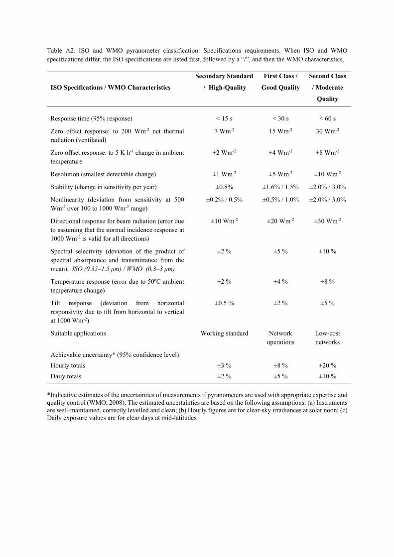
Table A2. ISO and WMO pyranometer classification: Specifications requirements. When ISO and WMO specifications differ, the ISO specifications are listed first, followed by a “/”, and then the WMO characteristics.
ISO Specifications / WMO Characteristics
Secondary Standard
/ High-Quality
First Class /
Good Quality
Second Class
/ Moderate
Quality
Response time (95% response) < 15 s < 30 s < 60 s
Zero offset response: to 200 Wm-2 net thermal radiation (ventilated)
7 Wm-2 15 Wm-2 30 Wm-2
Zero offset response: to 5 K h-1 change in ambient temperature
±2 Wm-2 ±4 Wm-2 ±8 Wm-2
Resolution (smallest detectable change) ±1 Wm-2 ±5 Wm-2 ±10 Wm-2
Stability (change in sensitivity per year) ±0.8% ±1.6% / 1.5% ±2.0% / 3.0%
Nonlinearity (deviation from sensitivity at 500 Wm-2 over 100 to 1000 Wm-2 range)
±0.2% / 0.5% ±0.5% / 1.0% ±2.0% / 3.0%
Directional response for beam radiation (error due to assuming that the normal incidence response at 1000 Wm-2 is valid for all directions)
±10 Wm-2 ±20 Wm-2 ±30 Wm-2
Spectral selectivity (deviation of the product of spectral absorptance and transmittance from the mean). ISO (0.35–1.5 μm) / WMO (0.3–3 μm)
±2 % ±5 % ±10 %
Temperature response (error due to 50ºC ambient temperature change)
±2 % ±4 % ±8 %
Tilt response (deviation from horizontal responsivity due to tilt from horizontal to vertical at 1000 Wm-2)
±0.5 % ±2 % ±5 %
Suitable applications Working standard Network operations
Low-cost networks
Achievable uncertainty* (95% confidence level):
Hourly totals
Daily totals
±3 %
±2 %
±8 %
±5 %
±20 %
±10 %
*Indicative estimates of the uncertainties of measurements if pyranometers are used with appropriate expertise and quality control (WMO, 2008). The estimated uncertainties are based on the following assumptions: (a) Instruments are well-maintained, correctly levelled and clean; (b) Hourly figures are for clear-sky irradiances at solar noon; (c) Daily exposure values are for clear days at mid-latitudes

Table A3. Minimum specifications requirements for long-wave radiation sensors (i.e. pyrgeometers) used at ICOS stations.
Sensor Specifications / Characteristics ICOS requirements
Response time (95% response) < 30 s
Stability (change in sensitivity per year) < 1%
Nonlinearity (from -200 W m-2 to +200 W m-2) < 1%
Temperature response (for a 50ºC temperature change) < 4%
Zero offset response: to 5 K h-1 change in ambient temperature < 4 Wm-2
Tilt error < 1%
Spectral range (wavelengths where response is greater than 50 % of maximum)
4.5-40 µm
Table A4: Minimum specifications requirements for PAR Quantum sensors used at ICOS stations.
Sensor Specifications / Characteristics ICOS requirements
Response time (95% response) < 1 s
Stability (change in sensitivity per year) < 2%
Nonlinearity (deviation in sensitivity up to 104 μmol m-2 s-1) < 1%
Directional response error for beam radiation (Cosine response + azimuthal response)
< 10%
Temperature response (for a 50ºC temperature change) < 0.15%/ºC
Spectral range (wavelengths where response is greater than 50 % of maximum)
400-700 nm ± 5 nm
Field of view 180º

Table A5. ICOS target uncertainty and estimated measurement uncertainty or target uncertainty in high performance radiation measurement networks.
ICOS
Target
BSRN
1997 Target*
BSRN
2004
Target**
SIRS Measurement
Uncertainty†
Incoming short-wave (solar) / SW_IN
±5%#/ ±10%
±2.0% or 5 Wm-2
±2.0% or 5 Wm-2
±6.0% or 10 Wm-2
Outgoing short-wave (reflected) / SW_OUT
±10% ±3% ±2% ±6.0% or 15 Wm-2
Incoming long-wave (atmospheric) / LW_IN
±10% ±5% or
10 Wm-2 ±2.0% or 3 Wm-2
±2.5% or 4 Wm-2
Outgoing long-wave (terrestrial) / LW_OUT
±10% ±5% or
10 Wm-2 ±2.0% or 3 Wm-2
±2.5% or 4 Wm-2
Incoming PPFD / PPFD_IN ±10% NA NA NA
Outgoing PPFD / PPFD_OUT ±10% NA NA NA
Diffuse short-wave / SW_DIF ±10% NA NA NA
Diffuse PPFD / PPFD_DIF ±10% NA NA NA
#using secondary standard dedicated
pyranometer
*from WCRP-64,
Nov 1991
**Estimated from
measurements
(Mc Arthur, 2005)
†Estimated from measurements (Stoffel, 2005)