RADAR POLARIMETRY SAPHIR - Earth Online - ESA · RADAR POLARIMETRY TerraSAR – X Imaging Modes....
28
© E. Pottier, L. Ferro-Famil (01/2004) SAPHIR SAPHIR RADAR POLARIMETRY RADAR POLARIMETRY POLARIMETRIC SPACEBORNE SAR SENSORS ENVISAT / ASAR ESA (EU) 2002 C-Band (Sngl / Twin) HH, VV, (HH,VV), (HH,HV), (HV,VV) SIR-C NASA / JPL (USA) April 1994 (10 days) October 1994 (10 days) L, C-Band (Quad) ALOS / PALSAR NASDA / JAROS (J) 2004 L-Band HH,VV, (HH,HV), (VV,VH) TERRASAR BMBF / DLR / ASTRIUM 2007 X-Band (Twin) (HH,VV), (HH,HV), (HV,VV) L-Band (Quad) RADARSAT 2 CSA / MDA (CA) 2005 C-Band (Quad)
Transcript of RADAR POLARIMETRY SAPHIR - Earth Online - ESA · RADAR POLARIMETRY TerraSAR – X Imaging Modes....

© E. Pottier, L. Ferro-Famil (01/2004)
SAPHIR
SAPHIR
RADAR POLARIMETRYRADAR POLARIMETRY
POLARIMETRIC SPACEBORNE SAR SENSORS
ENVISAT / ASARESA (EU)
2002C-Band (Sngl / Twin)
HH, VV, (HH,VV),(HH,HV), (HV,VV)
SIR-CNASA / JPL (USA)
April 1994 (10 days)October 1994 (10 days)
L, C-Band (Quad)
ALOS / PALSARNASDA / JAROS (J)
2004L-Band
HH,VV, (HH,HV), (VV,VH)TERRASAR
BMBF / DLR / ASTRIUM2007
X-Band (Twin)(HH,VV), (HH,HV), (HV,VV)
L-Band (Quad)RADARSAT 2
CSA / MDA (CA)2005
C-Band (Quad)

© E. Pottier, L. Ferro-Famil (01/2004)
SAPHIR
SAPHIR
RADAR POLARIMETRYRADAR POLARIMETRY
BONANZA CREEK (USA) LAMANCHA (S)
DEATH VALLEY (USA) OETZTAL (AUT)
KILAUEA CRATER (USA)

© E. Pottier, L. Ferro-Famil (01/2004)
SAPHIR
SAPHIR
RADAR POLARIMETRYRADAR POLARIMETRY
SRTM / X-SAR
February 2000Single Pol Channel
SRTM: X-SARSpatial Resolution: 1 Arc Sec = 30m
Height Accuracy : 6-10 m
GTOP-030Spatial Resolution: 30 Arc Sec = 1km
Height Accuracy : 100 m – 500 m

© E. Pottier, L. Ferro-Famil (01/2004)
SAPHIR
SAPHIR
RADAR POLARIMETRYRADAR POLARIMETRY
SRTM/X-SAR Image of Volcano Koma-ga-Take, Hokkaido

© E. Pottier, L. Ferro-Famil (01/2004)
SAPHIR
SAPHIR
RADAR POLARIMETRYRADAR POLARIMETRY
SRTM/X-SAR Image of Mount Kotopaxi

© E. Pottier, L. Ferro-Famil (01/2004)
SAPHIR
SAPHIR
RADAR POLARIMETRYRADAR POLARIMETRY
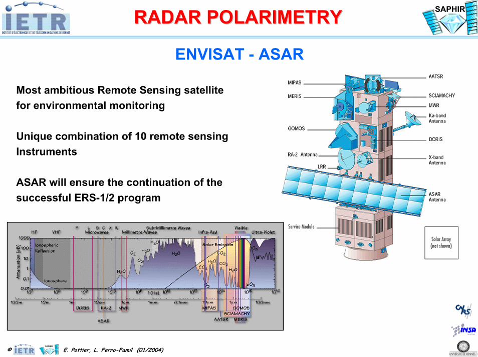
ENVISAT - ASAR
© E. Pottier, L. Ferro-Famil (01/2004)
SAPHIR
SAPHIR
RADAR POLARIMETRYRADAR POLARIMETRY
ENVISAT - ASAR
Most ambitious Remote Sensing satellitefor environmental monitoring
Unique combination of 10 remote sensingInstruments
ASAR will ensure the continuation of the successful ERS-1/2 program

© E. Pottier, L. Ferro-Famil (01/2004)
SAPHIR
SAPHIR
RADAR POLARIMETRYRADAR POLARIMETRY
ENVISAT - ASAR
ASAR AntennaENVISAT Integration
Twin - Pol
(HH,VV), (HH,HV), (HV,VV)
ASAR TR Modules

© E. Pottier, L. Ferro-Famil (01/2004)
SAPHIR
SAPHIR
RADAR POLARIMETRYRADAR POLARIMETRY
ENVISAT – ASAR – MERIS

© E. Pottier, L. Ferro-Famil (01/2004)
SAPHIR
SAPHIR
RADAR POLARIMETRYRADAR POLARIMETRY
ENVISAT - ASARBRETAGNE
Instrument: (ASAR)
Date of Acquisitions: 5 October 200320 December 200322 February 2004
Instrument features:Image Mode Precision (150 m resolution)
ASAR Mode: Image Swath 2
Orbit Direction: Descending Orbit number: 04249
ASAR Polarization: V/V
Coordinates: NW Lat/Long: N 50.42 / W 3.37 NE Lat/Long: N 49.56 / E 2.23 SE Lat/Long: N 46.22 / E 1.07 SW Lat/Long: N 47.06 / W 4.19

© E. Pottier, L. Ferro-Famil (01/2004)
SAPHIR
SAPHIR
RADAR POLARIMETRYRADAR POLARIMETRY
ENVISAT - ASARBARCELONA
Instrument: (ASAR)
Date of Acquisitions: 19 February 200417 October 200319 June 2003
Instrument features:Image Mode Precision (30 m resolution)
ASAR Mode: Image Swath 2
Orbit Direction: Descending Orbit number: 10318, 03304, 06811
ASAR Polarization: V/V
Coordinates: NE Lat/Long: N 41.81 / E 2.64 NW Lat/Long: N 41.81 / E 1.70 SW Lat/Long: N 41.03 / E 1.70 SE Lat/Long: N 41.03 / E 2.64

© E. Pottier, L. Ferro-Famil (01/2004)
SAPHIR
SAPHIR
RADAR POLARIMETRYRADAR POLARIMETRY
ALOS - PALSAR
ALOS : Advanced Land Observing SatellitePALSAR : Phase Array L-Band SAR

© E. Pottier, L. Ferro-Famil (01/2004)
SAPHIR
SAPHIR
RADAR POLARIMETRYRADAR POLARIMETRY
ALOS - PALSAR
Launch Date June 2004Launch Vehicle H-IIASpacecraft Mass 4,000kgGenerated Power 7kW
Orbit 691.65kmSun Synchronous
Repeat Cycle(Sub-Cycle)
46 days( 2 days )
PRISM AVNIR-2
PALSAR
Data RelayAntenna
Solar Array
Star Tracker
GPS Antenna
Flight Direct io
nEarth
PRISM : Panchromatic Remote Sensing Instruments for Stereo Mapping AVNIR-2: Advanced Visible and Near Infrared Radiometer type 2 PALSAR: Phased Array type L-band Synthetic Aperture Radar
ALOS Satellite SystemALOS Satellite System

© E. Pottier, L. Ferro-Famil (01/2004)
SAPHIR
SAPHIR
RADAR POLARIMETRYRADAR POLARIMETRY
ALOS Parameters
Launch Date June 2004Type Sun -Synchronous Sub -recurrentLocal Time at DN 10:30 AM ± 15min.Altitude 691.65kmInclination 98.16 degreesRevolutions per day 14+27/46Period 98.7 minutesLongitude Repeatability +/ -2.5km (above equator)Max. operation period 70 minutes per orbitData collection 1 DRTS +direct transmissionYaw steering Selective ON/ OFFAttitude error each axis 0.4e -4°(determination),
0.1 °(maintenance)

© E. Pottier, L. Ferro-Famil (01/2004)
SAPHIR
SAPHIR
RADAR POLARIMETRYRADAR POLARIMETRY
PALSAR Characteristics
Band widthPulse widthSampling frequencyPRFObservation sideTrans. peak powerNo. of TR modulesNo. of antenna beamsSTCDataAGC/MGCMGCSTCCenter frequencyChirpData ratePRF changes per orbitPeriod of AGC mon.polarizationsNumber of modes
28.0/14.0MHz27.0/16.0µs (full pol mode)32.0/16.0MHz1500~2500 HzRight hand side of the moving dir.2 kW8018+5 (Scan SAR)selective(0-7 dB in STC ON)I+Q with 5/3 bitsselective0-44dB0-7dB1270MHz(L -band)Down chirp (Digital)240/120Mbps7 times in a half orbitEvery 32 pulsesHH, VV, HH+HV, VV+VH, full pol.132
© E. Pottier, L. Ferro-Famil (01/2004)
SAPHIR
SAPHIR
RADAR POLARIMETRYRADAR POLARIMETRY
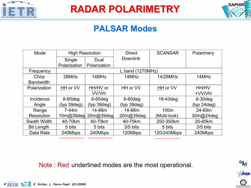
PALSAR Modes
High ResolutionModeSingle
PolarizationDual
Polarization
DirectDownlink
SCANSAR Polarimery
Frequency L band (1270MHz)Chirp
Bandwidth28MHz 14MHz 14MHz 14/28MHz 14MHz
Polarization HH or VV HH/HV orVV/VH
HH or VV HH or VV HH/HV+VV/VH
IncidenceAngle
8-60deg(typ 39deg)
8-60deg(typ 39deg)
8-60deg(typ 39deg)
18-43deg 8-30deg(typ 24deg)
RangeResolution
7-44m10m@39deg
14-88m20m@39deg
14-88m20m@39deg
100m(Multi-look)
24-89m30m@24deg
Swath Width 40-70km 40-70km 40-70km 250-350km 20-65kmBit Length 5 bits 5 bits 3/5 bits 5 bits 3/5 bitsData Rate 240Mbps 240Mbps 120Mbps 120/240Mbps 240Mbps
Note : Red underlined modes are the most operational.

© E. Pottier, L. Ferro-Famil (01/2004)
SAPHIR
SAPHIR
RADAR POLARIMETRYRADAR POLARIMETRY
PALSAR Imaging Modes
PALSAR Observation GeometryPALSAR Observation Geometry
Off-nadir : 9.9 deg. - 50.8 deg.(nominal operation : 34.3 deg.)
#1
#18
#1
#5
350km
Off-nadir : 20.1 deg. - 36.5 deg.
870km
90 kmIncident : 8 deg. - 60 deg.
Fine mode ( #1 - #18)Direct downlink mode ( #1 - #18)Polarimetric mode ( #1 - #12)
ScanSAR mode (3scans - 5scans)
380 km70km
Sub-satellite track
© E. Pottier, L. Ferro-Famil (01/2004)
SAPHIR
SAPHIR
RADAR POLARIMETRYRADAR POLARIMETRY
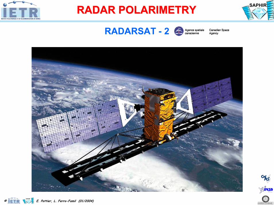
RADARSAT - 2

© E. Pottier, L. Ferro-Famil (01/2004)
SAPHIR
SAPHIR
RADAR POLARIMETRYRADAR POLARIMETRY
RADARSAT - 2
Orbit ParametersRADARSAT-2 will operate in an orbit identical as RADARSAT-1 except for an offset in time

© E. Pottier, L. Ferro-Famil (01/2004)
SAPHIR
SAPHIR
RADAR POLARIMETRYRADAR POLARIMETRY
RADARSAT - 2
Imaging Modes
Beam Mode SwathWidth(nominal)
Range ofIncidenceAngles (?)
ApproximateResolutionGrd Rg x Az
Standard 100 km 20-49 25 x 28 mWide 150 km 20-45 25 x 28 mLow Incidence 170 km 10-23 40 x 28 mHigh Incidence 70 km 50-60 20 x 28 mFine 50 km 37-49 10 x 9 mScanSAR Wide 500 km 20-46 100 x 100 m
Selective Polarization
Transmit H or VReceive H or V or(H and V)
ScanSAR Narrow 300 km 20-49 50 x 50 m
Standard Quad-Pol
25 km 20-41 25 x 28 mPolarimetricTransmit H and V onalternate pulsesReceive H and V onevery pulse
Fine Quad-Pol 25 km 20-41 11 x 9 m
Multi-Look Fine 50 km 30-40 11 x 9 mSelective SinglePolarizationTransmit H or VReceive H or V Ultra-fine 20 km 30-50 3 x 3 m

© E. Pottier, L. Ferro-Famil (01/2004)
SAPHIR
SAPHIR
RADAR POLARIMETRYRADAR POLARIMETRY
RADARSAT - 2
Imaging Modes

© E. Pottier, L. Ferro-Famil (01/2004)
SAPHIR
SAPHIR
RADAR POLARIMETRYRADAR POLARIMETRY
TerraSAR – Missions
TerraSAR – XTwin - Pol
(HH,VV), (HH,HV), (HV,VV)
TerraSAR – LQuad - Pol

© E. Pottier, L. Ferro-Famil (01/2004)
SAPHIR
SAPHIR
RADAR POLARIMETRYRADAR POLARIMETRY
TerraSAR – X
Center Frequency: 9.65 GHz (X-Band)Transmit Bandwidth: 5 ... 150 MHz nominal; 300 MHz experimentalTR Module RF Output Power: 38.5 dBm nominal; 39.0 dBm max.Nominal Radar Duty Cycle: 18 % nominal; 20 % max.Radiated peak power output: 2260 WSystem Noise Figure: 5 dBQuantization of Signal: 8 bit I / 8 bit QSAR Data Compression: online BAQPulse Repetition Frequency Range: 3 ... 6.5 kHzPolarization: HH / VV / HV / VH
Antenna Dimension Azimuth: 4.784 m Elevation: 0.704 m
Beamwidth (uniform excitation) Azimuth: 0.33° Elevation: 2.3°Scan Angle Azimuth: ± 0.75° Elevation: ± 19.2°

© E. Pottier, L. Ferro-Famil (01/2004)
SAPHIR
SAPHIR
RADAR POLARIMETRYRADAR POLARIMETRY
TerraSAR – X Imaging Modes
Flight direction
Nadir Track
45°
20°
SwathWidth100 km
Scan SAR Mode
Flight direction
Nadir Track
45°
20°
SwathWidth100 km
Scan SAR Mode Spotlight ModeSpotlight ModeStrip Map ModeStrip Map ModeResolution: 3 m ? 1,5 m ... 3Scene Size: 100 km ?Resolution: 3 m ? 1,5 m ... 3Scene Size: 100 km ?
Resolution: 1 m ? 1,5 m ... 3Scene Size: 5 km...10 km ?Resolution: 1 m ? 1,5 m ... 3Scene Size: 5 km...10 km ?
,5 m100 km
,5 m100 km
,5 m10 km,5 m10 km
Resolution: 3 m ? 1,5 m ... 3Scene Size: 100 km ?Resolution: 3 m ? 1,5 m ... 3Scene Size: 100 km ?
,5 m30 km
,5 m30 km
• The data collection incidence angle range is from 15° to 60°• Dual polarisation data acquisition is possible in all operational modes• 300 MHz experimental mode with 0.5 m slant range • Further experimental modes are feasible due to the Dual Receiving Antenna

© E. Pottier, L. Ferro-Famil (01/2004)
SAPHIR
SAPHIR
RADAR POLARIMETRYRADAR POLARIMETRY
The Future
CartWheel (D. Massonet CNES)

© E. Pottier, L. Ferro-Famil (01/2004)
SAPHIR
SAPHIR
RADAR POLARIMETRYRADAR POLARIMETRY
The Future
Courtesy of Pr W.M. Boerner

© E. Pottier, L. Ferro-Famil (01/2004)
SAPHIR
SAPHIR
RADAR POLARIMETRYRADAR POLARIMETRY
The Future
Courtesy of Pr W.M. Boerner

© E. Pottier, L. Ferro-Famil (01/2004)
SAPHIR
SAPHIR
RADAR POLARIMETRYRADAR POLARIMETRY
The Future
I.S.S International Space Station