RAAF Base Williamtown - Department of DefenceDefending Australia and its National Interests Project...
3
Defending Australia and its National Interests www.defence.gov.au About the Investigation The Department of Defence (Defence) has engaged independent environmental consultants to undertake an environmental investigation and assessment of the soil, surface water, sediment, biota and groundwater at and in the vicinity of RAAF Base Williamtown (the base) and surrounds (off-base), including in the NSW Environmental Protection Authority (EPA) investigation area. The purpose of the investigation was to understand impacts from the historical use of aqueous film forming foam (AFFF), which are now known to have contained per- and poly- fluoroalkyl substances (PFAS) including perfluorooctane sulfonate (PFOS) and perfluorooctanoic acid (PFOA). Defence has phased out the use of AFFF containing PFOS and PFOA as active ingredients and is proactively managing legacy contamination across its estate. Defence undertook a Stage 1 (desktop) review of the use of PFOS and PFOA at the base in 2013. During 2014-2015 Stage 2A sampling and analysis were undertaken on- and off-base, which were reported in September 2015. These investigations found that PFOS and PFOA were present in soil, sediment, surface and groundwater and in some biota (plants and animals) both on- and off-base. Stage 2B Investigation Objectives Stage 2B commenced in late 2015. Some of the objectives of the Stage 2B investigations were to: • Improve the understanding of the historical and current uses of PFAS. • Assess the nature and extent of PFAS and its movement through the environment. • Gather data to develop a Human Health Risk Assessment. • Gather data to develop future management strategies for PFAS impacts. Stage 2B Investigations Stage 2B investigations included testing and analysis of the following samples within the investigation area: • Groundwater (1048 samples), surface water (118 RAAF Base Williamtown Stage 2B Environmental Investigation Report – Key Findings and Next Steps Project Update August 2016 samples), soil (620 samples) and sediment (131 samples). • Residential bore water and tank rain water (211 bore and 166 tank samples). • Terrestrial biota (including grass, fruit, vegetables, eggs and dry land animals) and aquatic biota (water animals including fish, prawns and shellfish). 116 new groundwater monitoring wells were also installed as part of the Stage 2B investigations. Hydrogeological testing was conducted and numerical groundwater flow and PFAS transport models were developed. Stage 2B Report - Key findings: Source Areas Seven key PFAS source areas have been identified at the base. No new key source areas were identified compared to 2015 report. The key PFAS source areas on the base include a disused fire training pit, former fire station, landfills and wastewater and sewerage treatment plants. A number of potential off-base PFAS source areas were identified such as fire stations, fuel depots and historical road vehicle and aircraft incident sites. These areas have not been tested as part of the Stage 2B Environmental Investigation. The predominant use of PFAS was fire training activities and in emergency response situations. PFAS behaviour Where AFFF has been historically used, it was found PFAS migrates vertically downward from source areas through the soil to shallow groundwater in the Tomago Sand Beds, where it moves with the groundwater. PFAS also migrates laterally from source areas through the surface water drainage network across the base and off- base areas. The lateral migration of PFAS in surface water appears to have spread the impact more widely than would have been expected by transport in groundwater alone. While AFFF containing high concentrations of PFAS is no longer used at the base, residual PFAS in soil, sediment in drains and lakes, and from pavements is likely to continue leaching to surface and groundwater for the immediate future.
Transcript of RAAF Base Williamtown - Department of DefenceDefending Australia and its National Interests Project...

Defending Australia and its National Interestswww.defence.gov.au
Defending Australia and its National Interestswww.defence.gov.au
About the InvestigationThe Department of Defence (Defence) has engaged independent environmental consultants to undertake an environmental investigation and assessment of the soil, surface water, sediment, biota and groundwater at and in the vicinity of RAAF Base Williamtown (the base) and surrounds (off-base), including in the NSW Environmental Protection Authority (EPA) investigation area.
The purpose of the investigation was to understand impacts from the historical use of aqueous film forming foam (AFFF), which are now known to have contained per- and poly-fluoroalkyl substances (PFAS) including perfluorooctane sulfonate (PFOS) and perfluorooctanoic acid (PFOA). Defence has phased out the use of AFFF containing PFOS and PFOA as active ingredients and is proactively managing legacy contamination across its estate.
Defence undertook a Stage 1 (desktop) review of the use of PFOS and PFOA at the base in 2013. During 2014-2015 Stage 2A sampling and analysis were undertaken on- and off-base, which were reported in September 2015. These investigations found that PFOS and PFOA were present in soil, sediment, surface and groundwater and in some biota (plants and animals) both on- and off-base.
Stage 2B Investigation Objectives Stage 2B commenced in late 2015. Some of the objectives of the Stage 2B investigations were to:• Improve the understanding of the historical and current
uses of PFAS.• Assess the nature and extent of PFAS and its movement
through the environment.• Gather data to develop a Human Health Risk Assessment.• Gather data to develop future management strategies for
PFAS impacts.
Stage 2B Investigations Stage 2B investigations included testing and analysis of the following samples within the investigation area: • Groundwater (1048 samples), surface water (118
RAAF Base Williamtown Stage 2B Environmental Investigation Report – Key Findings and Next Steps
Project UpdateAugust 2016
Project UpdateAugust 2016
samples), soil (620 samples) and sediment (131 samples).
• Residential bore water and tank rain water (211 bore and 166 tank samples).
• Terrestrial biota (including grass, fruit, vegetables, eggs and dry land animals) and aquatic biota (water animals including fish, prawns and shellfish).
116 new groundwater monitoring wells were also installed as part of the Stage 2B investigations. Hydrogeological testing was conducted and numerical groundwater flow and PFAS transport models were developed.
Stage 2B Report - Key findings:Source AreasSeven key PFAS source areas have been identified at the base. No new key source areas were identified compared to 2015 report.
The key PFAS source areas on the base include a disused fire training pit, former fire station, landfills and wastewater and sewerage treatment plants.
A number of potential off-base PFAS source areas were identified such as fire stations, fuel depots and historical road vehicle and aircraft incident sites. These areas have not been tested as part of the Stage 2B Environmental Investigation.
The predominant use of PFAS was fire training activities and in emergency response situations.
PFAS behaviourWhere AFFF has been historically used, it was found PFAS migrates vertically downward from source areas through the soil to shallow groundwater in the Tomago Sand Beds, where it moves with the groundwater.
PFAS also migrates laterally from source areas through the surface water drainage network across the base and off-base areas. The lateral migration of PFAS in surface water appears to have spread the impact more widely than would have been expected by transport in groundwater alone.
While AFFF containing high concentrations of PFAS is no longer used at the base, residual PFAS in soil, sediment in drains and lakes, and from pavements is likely to continue leaching to surface and groundwater for the immediate future.
NSW Agencies Defence is cooperating in the investigation and management of the contamination with a number of NSW Government agencies. The following NSW Government agencies have information which may be relevant:
• NSW EPA: 131 555 • NSW Health: 1300 066 055• NSW Department of Primary Industries: - Fisheries closure: 4982 1232 - Agriculture: 1800 808 095• NSW Food Authority Helpline: 1300 552 406• NSW Department of Primary Industries: 1300 550 474• Rural Financial Counselling Service (NSW Northern
Region): 6662 5055
Keeping the community informed Defence is committed to regularly updating the community throughout the investigation. Updates will be provided through the project website, community information sessions, direct mail and information sheets as new information becomes available. Enquiries or requests relating to individual properties will be considered on a case-by-case basis.
Contact the project team Phone: 1800 011 443 freecall (business hours)Web: www.defence.gov.au/id/WilliamtownEmail: [email protected]: RAAF Base Williamtown Stage 2 Environmental Investigation Project C/AECOM Australia Pty Ltd PO Box 1307 Fortitude Valley Qld 4006
National Hotline Number: 1800 365 414Email: [email protected]
Media enquiries should be directed to Defence Media Operations on (02) 6127 1999 or [email protected].
Next stepsFurther considerations: The results of the Stage 2B investigation provide an improved understanding of the nature, extent and potential migration of PFAS within the NSW EPA Investigation Area based on data collected between late 2015 and early 2016.
Defence will undertake further work to collect and analyse data to better understand the nature and extent of PFAS within the investigation area. The outcomes of this Stage 2B investigation will inform these further assessments and will also inform ongoing environmental monitoring and future management decisions relating to RAAF Base Williamtown. The further assessments and ongoing monitoring programs of work will be developed in consultation with NSW EPA.
Community engagement: Defence will continue to engage with the community about the environmental investigations and community information events.
Human Health Risk Assessment (HHRA): A HHRA has been conducted to evaluate the potential human health risks to identified receptors within the Williamtown area. This report includes consideration of direct contact exposures to environmental media (e.g. skin contact with soil, groundwater, surface water, pore water and sediment) as well as secondary exposures via dietary intakes, including both seafood and home grown plant and animal produce (garden crops, eggs and pasture).
Ecological Risk Assessment (ERA): An ERA is being undertaken to assess the potential risk from identified PFAS impacts to ecological receptors with habitats present at the base and in the surrounding area. The ERA also considers the potential for wider ecosystem impacts to result from the accumulation of PFAS in terrestrial and aquatic organisms exposed to PFAS impacts. This assessment includes an ecological survey to identify potentially impacted plants, birds, fish and other animals, together with the analytical results of PFAS testing completed for the HHRA.
Defending Australia and its National Interestswww.defence.gov.au
Project UpdateAugust 2016
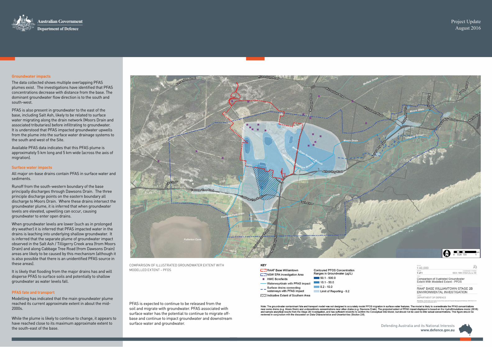
PFAS is expected to continue to be released from the soil and migrate with groundwater. PFAS associated with surface water has the potential to continue to migrate off-base and continue to impact groundwater and downstream surface water and groundwater.
Groundwater impactsThe data collected shows multiple overlapping PFAS plumes exist. The investigations have identified that PFAS concentrations decrease with distance from the base. The dominant groundwater flow direction is to the south and south-west.
PFAS is also present in groundwater to the east of the base, including Salt Ash, likely to be related to surface water migrating along the drain network (Moors Drain and associated tributaries) before infiltrating to groundwater. It is understood that PFAS impacted groundwater upwells from the plume into the surface water drainage systems to the south and west of the Site.
Available PFAS data indicates that this PFAS plume is approximately 5 km long and 5 km wide (across the axis of migration). Surface water impactsAll major on-base drains contain PFAS in surface water and sediments.
Runoff from the south-western boundary of the base principally discharges through Dawsons Drain. The three principle discharge points on the eastern boundary all discharge to Moors Drain. Where these drains intersect the groundwater plume, it is inferred that when groundwater levels are elevated, upwelling can occur, causing groundwater to enter open drains.
When groundwater levels are lower (such as in prolonged dry weather) it is inferred that PFAS impacted water in the drains is leaching into underlying shallow groundwater. It is inferred that the separate plume of groundwater impact observed in the Salt Ash / Tilligerry Creek area (from Moors Drain) and along Cabbage Tree Road (from Dawsons Drain) areas are likely to be caused by this mechanism (although it is also possible that there is an unidentified PFAS source in these areas).
It is likely that flooding from the major drains has and will disperse PFAS to surface soils and potentially to shallow groundwater as water levels fall.
PFAS fate and transportModelling has indicated that the main groundwater plume reached its current approximate extent in about the mid-2000s.
While the plume is likely to continue to change, it appears to have reached close to its maximum approximate extent to the south-east of the base.
"6"6"6
"6"6"6
"6 "6
"6 "6
"6"6
"6
"6
"6
"6
"6
"6
"6"6
"6
"6
Fullerton Cove
Lavis Lane
Fullerto
nCo
ve
Road
Hidea
way
Driv
e
MichaelD
r ive
Rookes
Roa
d
Marsh Road
Bar
rieClose
Med
owie
Road
Richardson Road
Cabbage Tree Road
Nelso
n Bay Road
Nelso
nBay
Road
Nels
onB
ayR
oad
Nelson Bay Road
Richardson Road
Richardson Road
Cabbage Tree Road
Richardson Road
Dawso
nsDr
ain
Til lige
rryCreek
Tilligerry Creek
Fourteen Foot Drain
Moors Drain Southern Branch 1
Moors Drain Northern Branch
Moffats Creek
Ten Foot Drain
Fourteen Foot Drain
Moors Drain
Moors Drain
Link Drain
SHEET
GDA 1994 MGA Zone 56COORDINATE SYSTEM
CLIENT
DEPARTMENT OF DEFENCE
PROJECT
RAAF BASE WILLIAMTOWN STAGE 2BENVIRONMENTAL INVESTIGATION
TITLE
A3
AEC
OM
GIS
Prin
ted:
Dat
e: 8
/08/
2016
\\
ausy
d1fp
001\
Pro
ject
s\60
4X\6
0479
059\
4. T
ech
wor
k ar
ea\4
.99
GIS
\02_
Map
s\G
140_
01_A
3L_I
nter
pret
edG
roun
dwat
erEx
tent
_Pub
lic_2
0160
803.
mxd
KEY
RAAF Base WilliamtownNSW EPA Investigation Area
"6 HWC BorefieldsWaterway/drain with PFAS impactGroundwater model extent of PFASimpact in 2016 based ongroundwater and surface waterinputs (HydroSimulations, 2016)Surface drains connectingwaterways with PFAS impactIndicative Extent of Southern Area
Contoured PFOS ConcentrationRanges in Groundwater (µg/L)
50.1 - 500.010.1 - 50.00.2 - 10.0Limit of Reporting - 0.2
Disclaimer: Spatial data used under licence from Land and Property Management Authority, NSW © 2015. ©Land and Property Information 2015
1 of 1
Comparison of Illustrated GroundwaterExtent With Modelled Extent - PFOS
SIZESCALE
1:40,000
!«N# 0 0.5 10.25km
Note: The groundwater contaminant fate and transport model was not designed to accurately model PFOS migration in surface water features. The model is likely to overestimate the PFAS concentrationsnear some drains (e.g. Moors Drain) and underestimate concentrations near other drains (e.g. Dawsons Drain). The projected extent of PFAS impact displayed is based on the HydroSimulations model (2016)and sample analytical results from the Stage 2B Investigation, and has sufficient reliability to confirm the Conceptual Site Model, but should not be used to infer actual concentrations. This figure should bereviewed in conjunction with the discussion on Data Characteristics and Uncertainties (Section 2.6).
COMPARISON OF ILLUSTRATED GROUNDWATER EXTENT WITH MODELLED EXTENT – PFOS

Defending Australia and its National Interestswww.defence.gov.au
Defending Australia and its National Interestswww.defence.gov.au
About the InvestigationThe Department of Defence (Defence) has engaged independent environmental consultants to undertake an environmental investigation and assessment of the soil, surface water, sediment, biota and groundwater at and in the vicinity of RAAF Base Williamtown (the base) and surrounds (off-base), including in the NSW Environmental Protection Authority (EPA) investigation area.
The purpose of the investigation was to understand impacts from the historical use of aqueous film forming foam (AFFF), which are now known to have contained per- and poly-fluoroalkyl substances (PFAS) including perfluorooctane sulfonate (PFOS) and perfluorooctanoic acid (PFOA). Defence has phased out the use of AFFF containing PFOS and PFOA as active ingredients and is proactively managing legacy contamination across its estate.
Defence undertook a Stage 1 (desktop) review of the use of PFOS and PFOA at the base in 2013. During 2014-2015 Stage 2A sampling and analysis were undertaken on- and off-base, which were reported in September 2015. These investigations found that PFOS and PFOA were present in soil, sediment, surface and groundwater and in some biota (plants and animals) both on- and off-base.
Stage 2B Investigation Objectives Stage 2B commenced in late 2015. Some of the objectives of the Stage 2B investigations were to:• Improve the understanding of the historical and current
uses of PFAS.• Assess the nature and extent of PFAS and its movement
through the environment.• Gather data to develop a Human Health Risk Assessment.• Gather data to develop future management strategies for
PFAS impacts.
Stage 2B Investigations Stage 2B investigations included testing and analysis of the following samples within the investigation area: • Groundwater (1048 samples), surface water (118
RAAF Base Williamtown Stage 2B Environmental Investigation Report – Key Findings and Next Steps
Project UpdateAugust 2016
Project UpdateAugust 2016
samples), soil (620 samples) and sediment (131 samples).
• Residential bore water and tank rain water (211 bore and 166 tank samples).
• Terrestrial biota (including grass, fruit, vegetables, eggs and dry land animals) and aquatic biota (water animals including fish, prawns and shellfish).
116 new groundwater monitoring wells were also installed as part of the Stage 2B investigations. Hydrogeological testing was conducted and numerical groundwater flow and PFAS transport models were developed.
Stage 2B Report - Key findings:Source AreasSeven key PFAS source areas have been identified at the base. No new key source areas were identified compared to 2015 report.
The key PFAS source areas on the base include a disused fire training pit, former fire station, landfills and wastewater and sewerage treatment plants.
A number of potential off-base PFAS source areas were identified such as fire stations, fuel depots and historical road vehicle and aircraft incident sites. These areas have not been tested as part of the Stage 2B Environmental Investigation.
The predominant use of PFAS was fire training activities and in emergency response situations.
PFAS behaviourWhere AFFF has been historically used, it was found PFAS migrates vertically downward from source areas through the soil to shallow groundwater in the Tomago Sand Beds, where it moves with the groundwater.
PFAS also migrates laterally from source areas through the surface water drainage network across the base and off-base areas. The lateral migration of PFAS in surface water appears to have spread the impact more widely than would have been expected by transport in groundwater alone.
While AFFF containing high concentrations of PFAS is no longer used at the base, residual PFAS in soil, sediment in drains and lakes, and from pavements is likely to continue leaching to surface and groundwater for the immediate future.
NSW Agencies Defence is cooperating in the investigation and management of the contamination with a number of NSW Government agencies. The following NSW Government agencies have information which may be relevant:
• NSW EPA: 131 555 • NSW Health: 1300 066 055• NSW Department of Primary Industries: - Fisheries closure: 4982 1232 - Agriculture: 1800 808 095• NSW Food Authority Helpline: 1300 552 406• NSW Department of Primary Industries: 1300 550 474• Rural Financial Counselling Service (NSW Northern
Region): 6662 5055
Keeping the community informed Defence is committed to regularly updating the community throughout the investigation. Updates will be provided through the project website, community information sessions, direct mail and information sheets as new information becomes available. Enquiries or requests relating to individual properties will be considered on a case-by-case basis.
Contact the project team Phone: 1800 011 443 freecall (business hours)Web: www.defence.gov.au/id/WilliamtownEmail: [email protected]: RAAF Base Williamtown Stage 2 Environmental Investigation Project C/AECOM Australia Pty Ltd PO Box 1307 Fortitude Valley Qld 4006
National Hotline Number: 1800 365 414Email: [email protected]
Media enquiries should be directed to Defence Media Operations on (02) 6127 1999 or [email protected].
Next stepsFurther considerations: The results of the Stage 2B investigation provide an improved understanding of the nature, extent and potential migration of PFAS within the NSW EPA Investigation Area based on data collected between late 2015 and early 2016.
Defence will undertake further work to collect and analyse data to better understand the nature and extent of PFAS within the investigation area. The outcomes of this Stage 2B investigation will inform these further assessments and will also inform ongoing environmental monitoring and future management decisions relating to RAAF Base Williamtown. The further assessments and ongoing monitoring programs of work will be developed in consultation with NSW EPA.
Community engagement: Defence will continue to engage with the community about the environmental investigations and community information events.
Human Health Risk Assessment (HHRA): A HHRA has been conducted to evaluate the potential human health risks to identified receptors within the Williamtown area. This report includes consideration of direct contact exposures to environmental media (e.g. skin contact with soil, groundwater, surface water, pore water and sediment) as well as secondary exposures via dietary intakes, including both seafood and home grown plant and animal produce (garden crops, eggs and pasture).
Ecological Risk Assessment (ERA): An ERA is being undertaken to assess the potential risk from identified PFAS impacts to ecological receptors with habitats present at the base and in the surrounding area. The ERA also considers the potential for wider ecosystem impacts to result from the accumulation of PFAS in terrestrial and aquatic organisms exposed to PFAS impacts. This assessment includes an ecological survey to identify potentially impacted plants, birds, fish and other animals, together with the analytical results of PFAS testing completed for the HHRA.