RA V TROPICAL CYCLONE COMMITTEE FOR THE … · cyclone “Evan” had been very difficult as it...
24
W O R L D M E T E O R O L O G I C A L O R G A N I Z A T I O N RA V TROPICAL CYCLONE COMMITTEE FOR THE SOUTH PACIFIC AND SOUTH-EAST INDIAN OCEAN FIFTEENTH SESSION (PORT VILA, VANUATU, 26 to 30 MAY 2014) FINAL REPORT
-
Upload
phungkhanh -
Category
Documents
-
view
215 -
download
0
Transcript of RA V TROPICAL CYCLONE COMMITTEE FOR THE … · cyclone “Evan” had been very difficult as it...
W O R L D M E T E O R O L O G I C A L O R G A N I Z A T I O N
RA V TROPICAL CYCLONE COMMITTEE
FOR THE
SOUTH PACIFIC AND SOUTH-EAST INDIAN OCEAN
FIFTEENTH SESSION
(PORT VILA, VANUATU, 26 to 30 MAY 2014)
FINAL REPORT

1
GENERAL SUMMARY OF THE WORK OF THE SESSION 1. ORGANIZATION OF THE SESSION (Agenda item 1) 1.1. Opening of the session (Agenda item 1.1) 1.1.1. At the kind invitation of the Government of Vanuatu, the fifteenth session of WMO Regional Association V Tropical Cyclone Committee for the South Pacific and South-East Indian Ocean (XV-RA V/TCC) was held in Port Vila, Vanuatu, from 26 to 30 May 2014. The opening ceremony commenced at 0900 hours on Monday, the 26 May 2014. 1.1.2. Mr. Jotham Napat, Permanent Representative of Vanuatu with WMO welcomed the participants to Vanuatu, and to XV-RA V/TCC. 1.1.3. On behalf of Mr. Michel Jarraud, Secretary-General of WMO, Dr. Taoyong Peng, Chief, Tropical Cyclone Programme, welcomed all the participants and expressed the sincere appreciation of WMO to the Honorable Minister James Bule, Minister for Climate Change, Environment, Meteorology, Geo-hazard, Energy, and Disaster Management (CEMGED) and through him to the Government of Vanuatu for hosting the XV-RA V/TCC. He also expressed his gratitude to Mr. Napat and his staff for the warm welcome and hospitality and for the excellent arrangements made to ensure the success of the session. Dr. Peng commended the Committee for the significant results achieved in improving warning services in the South Pacific and Southeast Indian Oceans with strong coordination and partnership. He also expressed appreciation to the Regional Specialized Meteorological Center / Tropical Cyclone Warning Center (RSMC / TCWCs) for providing forecasts, warnings and advisories for every tropical cyclone system to the Committee’s members. He emphasized the primary objective of the WMO Tropical Cyclone Programme (TCP) is to reduce damage and loss of lives caused by tropical cyclones to a minimum. Dr. Peng assured WMO’s continued support through the TCP for the Committee’s programmes and activities, and wished all the participants a very successful session and an enjoyable stay in Port Vila. 1.1.4. Mr. Mike Bergin, Chairman of the WMO Regional Association V (South-West Pacific) Tropical Cyclone Committee for the South Pacific and South-East Indian Ocean (RA V/TCC), on the onset of his remarks, congratulated the Honorable Mr. James Bule, Minister (CEMGED) on the commitment of the Government of Vanuatu to the on-going development of the Vanuatu Meteorology and Geo-hazard Department (VMGD). The Department is now among the highest performing National Meteorological Services (NMSs) in the region. Furthermore, Mr. Bergin reminded the meeting of the vast ocean areas in the Pacific and Indian Oceans covered by the RAV/TCC and of the vast array of small islands that require quality and timely tropical cyclone warning services. The Operational Plan that provides the framework for the coordination of these services is the highest priority for this meeting. He emphasised that to ensure the safety of life and property in the countries, NMSs must have strong engagement with the National Disaster Management Offices (NDMOs), media and other communities’ groups to ensure that people who are threatened by tropical cyclones are well informed to take appropriate actions. He also reminded the meeting that climate change would deliver possible fewer tropical cyclones but probably more intense tropical cyclones, and high quality early warning service is one of the best adaptation strategies. However, the rising sea level would make communities living close to the sea more vulnerable to storm surges. Mr. Bergin used recent example of the devastation caused by tropical cyclones “Evan” and “Ian” to remind the meeting of the need for further work to make sure people take early actions to remain safe. He also emphasised that early and late stages of tropical cyclones are equally devastating citing the extensive flooding in Australia from ex-tropical cyclone “Oswald” and the massive flooding and loss of life in the Solomon Islands before the system that was to become tropical cyclone “Ita” had even started to intensify. In concluding, Mr Bergin thanked the Government of Vanuatu for supporting the meeting and the Local Organizing Committee for the excellent preparations made for the meeting
2
1.1.5. His Honorable Mr. James Bule, Minister for Climate Change, Environment, Meteorology, Geo-hazard, Energy, and Disaster Management welcomed the participants to Port Vila and to XV-RA V/TCC. The Minister emphasized the vulnerability of Vanuatu to natural disasters and climate change. The impacts are increasing and would continue to affect the sustainable development of the country, underlying the need to mainstream disaster risk reduction, disaster risk management, and climate change adaptation into national planning and budgetary processes. The Minister highlighted the Government of Vanuatu commitment and the important roles played by NMSs, and this has been demonstrated by immense commitment to the development of VMGD during the past 10 years. These developments include a new Head Office building, the amalgamation of meteorology and geo-hazard, revision of the organization structure to increase number of staff to 89, and creation of a multi-hazard early warning center, development of a legal framework to establish a coordinated sectorial response to disasters, and digitization of 50 years of climate historical data. In concluding, the Honorable Minister wished the participants a successful meeting, and declared the meeting officially opened. 1.1.6. The session was attended by 30 participants, including 20 from the Committee’s member States and four participants from regional and international organizations. The list of participants is given in Appendix I. 1.2. Adoption of the agenda (Agenda item 1.2) 1.2.1. The Committee adopted the agenda for the session as given in Appendix II. 1.3. Election of vice-chairperson (Agenda item 1.3) 1.3.1. Mr. Jotham Napat (Vanuatu) was elected unanimously as vice-chairperson of XV-RA V/TCC. 1.4. Working arrangements for the session (Agenda item 1.4) 1.4.1. The Committee decided on its working hours and the arrangements for the session. 2. REPORT OF THE CHAIRPERSON OF THE COMMITTEE (Agenda item 2) 2.1. Mr. Mike Bergin, Chairman of RA V/TCC noted that the role of the Committee continues to grow as reflected in the decisions of the recent sixteenth session of Regional Association V (South-West Pacific) (XVI-RA V, Jakarta, Indonesia, May 2014). Furthermore, following the Committee’s meeting in 2008 the Severe Weather Forecast and Disaster Risk Reduction Demonstration Project (SWFDDP) commenced and has provided a significant increase in the services for severe weather across parts of the South Pacific region. Mr. Bergin hoped to see a continued working relationship with IOC-UNESCO through back-to-back meetings similar to that being organized in Samoa, in 2012. 2.2. The Chairman reminded the meeting that XVI-RA V re-established and expanded the Committee’s mandate to other severe weather and related events through a creation of the Task Team on Severe Weather Forecasting including Global Data Processing and Forecasting System (TT-SWFD/DPFS), and another Task Team on Coastal Inundation including Storm Surges (TT-CISS). The meeting is expected to develop the Terms of References for these Task Teams. 2.3. The Chairman reported that during the 2012/2013 tropical season there were 9 named tropical cyclones in the Australian Area of Responsibility (AOR, west of 160E) and 5 in the Regional Meteorological Specialized Center – Nadi’s (RSMC-Nadi) AOR. Of these, tropical cyclone “Evan” was the most devastating causing 14 casualties in Samoa and damages exceeding USD200 million in both Samoa and Fiji. The forecast track for tropical cyclone “Evan” had been very difficult as it approached Samoa from the west before re-
3
curving around it and then heading in a southerly direction towards Fiji. In Australia ex-tropical cyclone “Oswald” produced widespread heavy rain and flooding in Queensland causing 6 casualties and damages exceeding AUD2.4 billion. In Indonesia the system that would become tropical cyclone “Narelle” caused devastating flooding in the east of the country causing 31 casualties. 2.4. The Chairman reported that during the 2013/2014 tropical cyclone season there were 11 named tropical cyclones in Australia’s AOR (west of 160E) and 7 in RSMC-Nadi’s AOR. Of these, tropical cyclone “Ian” caused 1 casualty and in excess of USD4 million in damages in Tonga. In Queensland, tropical cyclone “Ita” caused over AUD$2 billion in damages. Tropical cyclone “Ita” was the most significant tropical cyclone of the season as it also produced devastating flooding in the Solomon Islands before it formed into a tropical cyclone. After impacting on Queensland, tropical cyclone “Ita” then weakened as it moved south through the Tasman Sea but then intensified rapidly into an extra-tropical low producing significant winds and damages on the west coast of the South Island of New Zealand. 2.5. The Chairman noted that the SWFDDP continued to be the most active area of work of the Committee. These include the Regional Subproject Management Team (RSMT) meeting in Nadi, 26-29 August 2013 and among other items approved criteria for transition of the project into operational phase, continued development of the website and, preparation of progress reports. While RSMC - Wellington continued to produce guidance products, the overall management of the project would need a transition to a regional organization during 2015. 2.6. The Chairman acknowledged the return of the Pacific International Training Desk operating in RSMC - Honolulu and the excellent training opportunities this would provide for staff from NMSs in the South Pacific region. 2.7. The Chairman noted that the distribution of data from the Japan Meteorological Agency (JMA) satellite “Himawari” would begin in 2015, and called on the Secretariat to ensure that suitable arrangements are put in place for NMSs in the South Pacific and Southeast Indian Oceans to receive the data. While internet services in the Committee’s member States are improving these can be expensive and intermittent in some countries. 2.8. The Chairman also noted that the Eight International Workshop on Tropical Cyclones (VIII-IWTC) would be held in Korea in December 2014 and called on WMO TCP to provide assistance for suitably qualified tropical cyclone forecasters to attend this important workshop. 2.9. In concluding, the Chairman reminded the Committee that the Operational Plan for the co-ordination of tropical cyclone warning services across the South Pacific and South-East Indian Oceans remains its most important and significant responsibility and the Plan is the very reason for the existence of the Committee. 3. COORDINATION WITHIN THE WMO TROPICAL CYCLONE PROGRAMME
(Agenda item 3) 3.1. The Committee was briefed on WMO Emergency Response to typhoon “Haiyan”, and related recommendations on follow-up actions by the 2014 Meeting of the Presidents of Technical Commissions (PTC-2014). The Committee was further informed that the Executive Council Working Group on Service Delivery (ECWG/SD) endorsed the recommendations by the PTC-2014, and considered to recommend to EC for consideration of endorsement. These follow-up actions are highlighted:
(a) To develop a standardized and Synergistic Operating Procedure (SOP) or Manual within the WMO Secretariat in cooperation with WMO Tropical Cyclone RSMCs / TCWCs and Members;
4
(b) To develop a clear, concise checklist technical guide to be included in SOP as recommendations to Members for urgent actions. This guide should link hazard information to actions to be taken by people;
(c) To establish a network of emergency contacts, including Members and partner
organizations;
(d) To develop and include impacts based and risk mapped tropical cyclone forecasting and warning information into the tropical cyclone advisories provided by RSMCs with activity specialization in tropical cyclones, and to provide training accordingly; and
(e) To develop guidance and technical tools to support Members’ activities in disaster
risk assessment and post-disaster analysis. 3.2. The Committee was briefed about the outcomes of annual / biennial sessions of other four regional Tropical Cyclone Committees held during the inter-sessional period, as follows:
(a) The twenty-first session of the RA I Tropical Cyclone Committee (TCC) was planned to be held in late 2014;
(b) The thirty-six session of the RA IV Hurricane Committee was held in Cancun,
Mexico from 7 to 10 April 2014; (c) The forty-sixth session of the ESCAP / WMO Typhoon Committee was held in
Bangkok, Thailand from 10 to 13 February 2014 (http://www.typhooncommittee.org/46th/index.html). Among its many decisions, it was decided to hold a joint session with the WMO / ESCAP Panel on Tropical Cyclones subject to the agreement by the Panel; and
(d) The forty-first session of the WMO / ESCAP Panel on Tropical Cyclones was held
in Dhaka, Bangladesh from 2 to 6 March 2014 (http://www.ptc-wmoescap.org/sessions.htm). The Panel agreed with the Typhoon Committee’s decision to hold a joint session in early March 2015 in ESCAP Building, in Bangkok, Thailand.
3.3. For the capacity development in tropical cyclone forecasting, WMO TCP held a number of workshops and training events in cooperation with its partners’ programmes, including the tenth Southern Hemisphere Training Course on Tropical Cyclones (https://www.wmo.int/pages/prog/www/tcp/Activities.html) and Public Weather Services (https://www.wmo.int/pages/prog/amp/pwsp/eventsworkshops_en.htm) which were held in Nadi, Fiji, from 23 September to 4 October 2013. It also organized attachment trainings jointly with the RSMCs Tokyo and New Delhi. 3.4. As regards to the tenth Southern Hemisphere Training Course on Tropical Cyclones and the Workshop on Public Weather Services, the Committee expressed its gratitude to Fiji for hosting the training course, and to Australian Bureau of Meteorology (BoM) for coordinating the organization of the two events. The Committee reiterated the key contribution of the training course to the capacity development of the Committee’s members. 3.5. The Committee noted with pleasure that the Tropical Cyclone Forecaster Website (TCFW) (http://severe.worldweather.wmo.int/TCFW) had been launched with hosting by Hong Kong, China, continued to be updated and easily accessible, and became an official WMO website, open to the public. The Committee also noted that the web version of the updated Global Guide to Tropical Cyclone Forecasting was uploaded to the web server hosted by BoM, and is in the final stage of thorough review before it is made accessible to users. The Committee expressed sincere appreciation to the author, with Mr Chip Guard of Guam, USA as Chief Editor, for his valuable voluntary contributions. The Committee also
5
requested the Secretariat to circulate a letter to the Committee’s members to announce the availability and the accessibility of the Guide. 3.6. The Committee noted that, among the priority actions of WMO TCP for 2014 and beyond such as organization of regional workshops and Tropical Cyclone Committees’ sessions, TCP would give its special emphasis on (a) maximizing the synergies of Tropical Cyclone Forecaster Website and the website for the new Global Guide to Tropical Cyclone Forecasting and (b) effective organization of the group trainings in Regions I, IV and V. 4. REVIEW OF THE 2012/2013 AND 2013/2014 CYCLONE SEASONS (Agenda item
4) 4.1. Review by RSMC Nadi-TCC (Agenda item 4.1) 4.1.1. During the 2012/2013 tropical cyclone season, tropical cyclone activities in RSMC Nadi’s AOR were below climatological average. In total, five tropical cyclones in RSMC Nadi’s AOR, four of these attained hurricane intensity and one was a Category 1 system. The first tropical cyclone named by RSMC Nadi was tropical cyclone “Evan”. It reached a Category 4 system and caused severe damages to Samoa and Fiji. Tropical cyclone “Freda” was the second Category 4 tropical cyclone named by RSMC Nadi, tracked mainly over open waters during its life cycle. Tropical cyclone “Freda” brought heavy rain causing flooding in parts of the Solomon Islands and New Caledonia. During the peak period of the season, tropical cyclone “Garry” was named the third tropical cyclone, passed in the Samoa waters and tracked over Southern Cook Islands with minimal damages. Tropical cyclone “Haley” was the fourth cyclone named by RSMC Nadi, a Category 1 system and tracked over waters between Southern Cook Islands and French Polynesia with no damages incurred. Later in the season, RSMC Nadi monitored and tracked tropical cyclone “Sandra” as the last cyclone existing in its AOR. Tropical cyclone “Sandra” attained hurricane intensity as it moved close to New Caledonia but posed no direct threat to the country. 4.1.2 Tropical cyclone activities during the 2013/2014 tropical cyclone season in RSMC Nadi’s AOR were slightly below climatological average. A total of six cyclones during the season, in which two of the systems attained hurricane strength, one reached storm intensity and three of the cyclones were Category 1 systems. The first tropical cyclone named and the most intense system (Category 5) to exist in RSMS Nadi’s AOR was tropical cyclone “Ian”. It formed over the waters between Fiji and Tonga, tracked over the Tongan Groups and resulted in considerable damages especially over central and Southern Islands. Later in the month of January, tropical cyclone “June” was named, and it moved close to New Caledonia as a Category 1 system with minimal damages experienced. Tropical cyclone “Edna” was the third cyclone named by TCWC Brisbane. It reached storm intensity when the system tracked close to New Caledonia. Later in the season, RSMC Nadi named its fourth cyclone as tropical cyclone “Kofi”. During the depression stage, heavy rain caused flooding over the eastern part of Viti-levu, the biggest island in Fiji. It moved close to the Southern part of Tonga as a Category 1 system and posed no direct threats to the Southern Islands. Tropical cyclone “Lusi” was the fifth cyclone named by RSMC Nadi. It was a Category 1 system when it moved over Vanuatu. Heavy rain and flooding were experienced over Northern and Central Islands Vanuatu. Later it gained hurricane strength as it continued to track southward. Tropical cyclone “Mike” was the sixth and the last cyclone to be named by RSMC Nadi during the 2013/2014 season. It was a Category 1 system, tracked over the Southern Cook Islands but incurred no severe damages. RSMC Wellington
4.1.3. During the 2012/2013 tropical cyclone season, a total of three out of the seven tropical cyclones exited the tropics into TCWC Wellington’s AOR. Only one, “Sandra” retained tropical cyclone status and a prolonged discussion with TCWC Brisbane to ensure Lord
6
Howe Island remained on cyclone warning until threat is over. During the 2013/2014 tropical cyclone season, seven out of the nine named tropical cyclones crossed into TCWC Wellington AOR. One of them named “Ita” dissipated as a tropical cyclone before crossing 25ᵒ South but its remnant rapidly intensify as an extra-tropical system. 4.1.4. Under the Severe Weather Forecasting and Disaster Risk Reduction Demonstration Project (SWFDDP), TCWC Wellington continued to provide twice daily production of the South Pacific Guidance (SPG) Charts for the tropical area from 150ᵒ East to 150ᵒ West between 2ᵒ North (to be adjusted to 5ᵒ North in the near future to ensure the whole of Kiribati is covered) and 25ᵒ South. Also, MetService/TCWC Wellington completed a second round of in-country training for the nine SWFDDP participating countries (Solomon Islands, Vanuatu, Kiribati, Tuvalu, Fiji, Samoa, Tonga, Niue and Cook Islands) 4.1.5. MetService/TCWC Wellington have been progressing with upgrades to SWFDDP website - MetConnect Pacific since the start of 2014 and work is expected to be completed by the end of June 2014. The upgrades include:
(a) Overhauling website graphics (e.g. new MetService branding);
(b) Making historical SPG charts available on the website; (c) Making historical UK Met Office and RSMC Darwin Numerical Weather Prediction
(NWP) images available on the website;
(d) Direct access to ACCESS-TC products from RSMC Darwin; (e) Direct access to the UK Met Office multi-model ensemble products; (f) Being able to display a collective of all Pacific Island SYNOPs;
(g) Enabling progress reports to be completed online; and (h) Creating an email alert when new Items are posted.
4.1.6. MetService/TCWC Wellington would like to acknowledge the role of the New Zealand Ministry for the Environment and the New Zealand Ministry of Foreign Affairs and Trade in funding the entire SWFDDP in-country training programme. They would also like to acknowledge the support provided by USA NOAA NWS staff in helping with and contributing to components of the training in Samoa and Fiji, and the support provided by US NOAA NWS in entirely funding the website upgrade. RSMC Honolulu 4.1.7. The 2013/2014 Central Pacific season experienced six tropical cyclones — one tropical depression, four tropical storms, and one hurricane. This was slightly above the normal of four to five tropical cyclones for the basin. Only tropical storm “Flossie” affected land as the center passed north of the Hawaiian Islands causing minor damage, power outages and one injury due to a lightning strike. 4.1.8. The 2012/2013 American Samoa tropical season was non-existent with only a Gale Watch issued for tropical cyclone “Ian”. Limited of observations and automated weather observing systems providing erroneous data due to calibration malfunctions continues to plague American Samoa. 4.1.9. The most significant development was the dissolution of the two Samoas’ agreement. American Samoa will now issue Gale, Tropical Storm, and Hurricane Watches and Warning based on the American criteria (see Table 1), which is based on one-minute
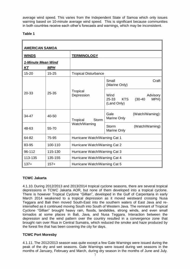
7
average wind speed. This varies from the Independent State of Samoa which only issues warning based on 10-minute average wind speed. This is significant because communities in both countries receive each other’s forecasts and warnings, which may be inconsistent. Table 1
AMERICAN SAMOA
WINDS TERMINOLOGY
1-Minute Mean Wind
KT MPH
15-20 15-25 Tropical Disturbance
20-33 25-35 Tropical Depression
Small Craft (Marine Only)
Wind Advisory 25-33 KTS (30-40 MPH) (Land Only)
34-47 40-50 Tropical Storm Watch/Warning
Gale (Watch/Warning): Marine Only
48-63 55-70 Storm (Watch/Warning) Marine Only
64-82 75-95 Hurricane Watch/Warning Cat 1
83-95 100-110 Hurricane Watch/Warning Cat 2
96-112 115-130 Hurricane Watch/Warning Cat 3
113-135 135-155 Hurricane Watch/Warning Cat 4
137+ 157+ Hurricane Watch/Warning Cat 5
TCWC Jakarta 4.1.10. During 2012/2013 and 2013/2014 tropical cyclone seasons, there are several tropical depressions in TCWC Jakarta AOR, but none of them developed into a tropical cyclone. There is however Tropical Cyclone “Gillian”, developed in the Gulf of Carpentaria in early March 2014 weakened to a tropical depression as it moved westward crossing Nusa Teggara and Bali then moved South-East into the southern waters of East Java and re-intensified as it continued moving South into South of Western Java. The remnant of Tropical Cyclone “Gillian” brought heavy rain, floods, landslides, strong winds, and even small tornados at some places in Bali, Java, and Nusa Teggara. Interaction between the depression and the wind pattern over the country resulted in a convergence zone that brought rain over Riua in Central Sumatra, which reduced the smoke and haze produced by the forest fire that has been covering the city for days. TCWC Port Moresby 4.1.11. The 2012/2013 season was quite except a few Gale Warnings were issued during the peak of the dry and wet seasons. Gale Warnings were issued during wet seasons in the months of January, February and March, during dry season in the months of June and July.
8
In 2012, TCWC Port Moresby/Papua New Guinea National Weather Service (PNG NWS) issued a Gale Warning that lasted into mid-February. Despite the warnings, a passenger ferry sailed and sunk in the Vitiaz Strait. Over 300 lives were lost at seas. This is a concern, as the owner of the ferry had access to and using weather information from other sources other than PNG NWS. 2013/2014 season saw Tropical Cyclone “Ita” moving South of the Southern Islands of Milne Bay Province. Tropical Cyclone “Ita” caused gale force winds and high seas on the Western side of Milne Bay islands. There was massive damage to food gardens and houses on Sudest Island and the Western Chain of the Islands, however there was no loss of life. The Government approved six (6) million kina for restoration and support to affected communities. TCWC/PNG NWS has not had upgrades of its Tropical Cyclone Monitoring and Tracking Systems (TCMTS), continued to use basic Forecasting Tools and Manual DVORAK, and communication systems are not adequate to properly carry out its monitoring and tracking of tropical cyclones. During Tropical Cyclone “Ita”, TCWC Brisbane supported TCWC Port Moresby Tropical in providing tracks and high seas warnings throughout the life of Tropical Cyclone “Ita”. 4.1.12. During the fourteenth session of the WMO Regional Association V (South-West Pacific) Tropical Cyclone Committee for the South Pacific and South-East Indian Ocean (Apia, Samoa, July 2012), the Committee noted that TCWC Port Moresby ability to provide warning services is inadequate and urged the RA V Management Group to consider a mission to Papua New Guinea to investigate the situation and develop a plan to address the situation. The Committee continued to request other RSMCs and TCWCs in the Region to provide support to RSMC Port Moresby to enable it to deliver warning services to the communities. Furthermore, support is needed to upgrade and improve TCWC Port Moresby Infrastructure, systems, operation and institutional arrangement. 4.2 Review by Members (Agenda Item 4.2) Federated States of Micronesia 4.2.1. In the past two tropical cyclone seasons (2012/2013 and 2013/2014) the Federated States of Micronesia was not directly affected by any major weather systems resulting from presence of tropical cyclones. However, 27 tropical cyclones (2 tropical depressions, 9 tropical storms, 16 typhoons) 34 tropical cyclones (13 tropical storms, 5 tropical depressions, 16 typhoons) tracked near the islands of Federated States of Micronesia in 2012 and 2013 respectively. These included Tropical Cyclone “Haiyan”. These tropical cyclones either formed West, South, or in the area of the State of Chuuk with the exception of a few that formed to the Southeast of the Federated States of Micronesia. Yap, which is the only Federated State of Micronesia’s State West of the State of Chuuk gave no reports of any significant impacts, except heavy rainfalls causing a few minor landslides and floods from these tropical cyclones. There was no loss of life in any of those events and property damage was also very minor. Some islands in the State of Chuuk experienced coastal inundations and subsequent crops damages. There are a few challenges experienced by the Federated States of Micronesia Weather Services Offices (WSO) including insufficient training for the staff and limit of internet that the telecommunications company is providing. In the near future. Federated States of Micronesia hope is to get these issues solved so that WSO Ponphei, WSO Yap and WSO Chuuk can expand to be able to prepare and issue localized weather forecasts and warning and to also provide climate information and services. Tonga 4.2.2. Tonga was not affected by a tropical cyclone during the 2012/2013 season. Tropical Cyclone “Ian” and Tropical Cyclone “Kofi” affected Tonga during the 2013/2014 season. On 11 January 2014, Tropical Cyclone “Ian” passed through the Eastern Ha’apai Group. Ha’apai Meteorological Station recorded 90 knots winds gusting to 130 knots with the lowest Mean Sea Level Pressure (MSLP) reading of 940 hectoPascal (hPa). One life was lost and considerable damages incurred to infrastructures, agriculture and fisheries and amongst
9
others with an overall estimation of damages around USD50 million. On the night of 1 March 2014, torrential rainfall, high sea surges in conjunction with the high tide associated with Tropical Cyclone “Kofi” led to flash flooding in some of the low lying areas of Tongatapu. Approximately 112 millimeters (mm) of rainfall recorded in 24 hours with wind intensity of 28 knots and gust up to 48 knots with MSLP reading of 993 Hpa. Challenges faced by the Tonga Meteorological Service (TMS) during these two cyclones that need to be rectified includes establishing backup communication systems in the outer islands’ Meteorological Stations and upgrading of existing backup communication systems and networks, automating the existing information and warning dissemination system and further capacity development in storm surge forecasting, Tropical Cyclone SATAID Analysis software and Tropical Cyclone Module software. Vanuatu 4.2.3. The tropical cyclone season for 2012/2013 was expected to be average with a total of three tropical weather systems affected Vanuatu. A Tropical Low Depression (20-22 November 2012) developed North of the Santa Cruz Islands in the Solomon Islands on 19 November 2012. The system moved South-Southeast into Vanuatu’s AOR at 12.6 Latitude South and 167.6 Longitude East on 21 of November. At 5:00 p.m on 21 November, it approached the TORBA Province. On 22 November, it moved east and away from the PENAMA and MALAPA Provinces. While the system was lurking within the Northern Islands of Vanuatu and within these provinces, TCWC Vanuatu issued Severe Weather Warnings for heavy rainfalls and Marine Strong Wind Warnings. There was no damage recorded when the depression impacted Vanuatu during 20 to 22 November. TCWC Vanuatu issued five Information and five Forecast Track Maps for this Tropical Low Depression. 4.2.4 Severe Tropical Cyclone “Freda” (29 December 2012 – 01 January 2013) initially developed as a Low Pressure Area near Guadalcanal in the Solomon Islands on 27 of December 2012. As it was leaving Rennelle and Belona Islands in the Solomon Islands and crossing 12 Latitude South and 160 Longitude East, it quickly developed into a Tropical Cyclone and was named “Freda”. Due to favorable weather and environmental condition near the region, it quickly developed into Category 2, Category 3 and Category 4 on 30 December before crossing over 15 Latitude South. At 12:43 a.m on 1 January 2013 (Local Time), Tropical Cyclone “Freda” was downgraded to Category 3 and it maintained its status until it crossed over 20 Latitude South and further downgraded to Category 2 on 2 of January. Tropical cyclone “Freda” travelled further South South-West and as it crossed over 20 Latitude South, curved East and travelled South-East past New Caledonia. While Tropical Cyclone “Freda” was lingering within the western parts of Vanuatu, TCWC Vanuatu issued Severe Weather Warnings for heavy rainfalls and Marine Strong Wind Warnings. TCWC Vanuatu issued six Information and five Forecast Track Maps for Tropical Cyclone “Freda”. 4.2.5. Severe tropical cyclone “Sandra” (8 – 11 March 2013) started as a Low Pressure Area near the coast of Queensland over the Coral Sea around 6 and 7 March 2013. Itinitially travelled East-Northeast and then East, and named on 9 March, as Tropical Cyclone “Sandra” as it crossed 155 Longitude East. Tropical Cyclone “Sandra” maintained an east-ward direction and then curved Southeast. At 11:00 p.m on 9 March, Tropical Cyclone “Sandra” became Category 1 and six hours later it developed into a Category 3 as it crossed 15 Latitude South and 160 Longitude East. Tropical Cyclone “Sandra” was further upgraded as Category 4 at mid-night on 11 March. Twelve hours later it was downgraded into Category 3 and further to Category 2 as it tracked Southeast to the west and southwest of New Caledonia during the following days. While Tropical Cyclone “Sandra” was lingering within the Western parts of Vanuatu, TCWC Vanuatu issued Severe Weather Warnings for heavy rainfalls and Marine Strong Wind Warnings. TCWC issued a total of four Advisories and four Forecast Track Maps for Tropical Cyclone “Sandra”. 4.2.6. During the 2013/2014 tropical cyclone season, ENSO conditions at the beginning of the season indicating neutral conditions in the Equatorial Pacific Region, with normal rainfall expected throughout Vanuatu. The neutral condition was forecast to remain until the end of
10
2013/2014 tropical cyclone season, with the number of cyclones within Vanuatu’s Area (Latitude 12South to Latitude 23South and Longitude 160East to Longitude 175East) to be around 2 to 4. 4.2.7 A Low Pressure System formed east of Vanuatu on 8 March 2014, and moved West-North-West towards Penama Province. Cloud organization improved, with good support aloft. On 9 March, it crossed the island of Maewo, and was expected to move towards Ambae. The system was moving between Torba, Sanma, Penama and Malampa Provinces, with cloud organization improving and surface winds increasing. The first advisory on the system was issued at 7:00 pm local time on 9 March 2014. At that time the system was a tropical low, with a moderate to high chance of it becoming a tropical cyclone as well as affecting the Northern Provinces within the next 24 to 48 hours. At 9:00 am, on 10 March 2014, the first warning on the system was issued by the Vanuatu Tropical Cyclone Warning Centre, even though the system was still a tropical low. This was because of the rapid intensification, good cloud organization, close proximity to the northern islands, and the possibility that the tropical low would become a tropical cyclone within the next 6 to 12 hours. At that time, the winds at the centre were estimated at 30 knots, with gusts to 45 knots. Damaging gale force winds were expected to affect all the Northern Provinces of Torba, Sanma, Penama and Malampa. The system was christened tropical cyclone “Lusi” at 11:00 am (local time) on 10 March 2014, when it was 90 kilometers north northeast of Santo and 55 kilometres southwest of the Banks Islands. The central pressure of the system was estimated at 990 hPa, and winds at the centre estimated at 40 knots. Tropical Cyclone Lusi (Category 1) took a south southeast tracked after it was named, and moved past Santo, Ambae and Ambrm. Tropical cyclone “Lusi” intensified to a Category 2 system as it moved past the northern parts of the Shefa Province, at 3:00 pm (local time) on 11 March 2014. At that time, the central pressure of the system was 984 hPa, and winds at the centre at 50 knots. Destructive storm force winds affected Malampa and Pemama Provinces. As the system took a south-southeast, then a southeast track, Strom Force winds eased at 6:00 am local time on 12 March 2014. As the system moved into the open waters between Fiji and Vanuatu, it increased its strength to a Category 3 system. At 6:00 pm local time, the final warning on the system was issued by the Vanuatu Tropical Cyclone Warning Center. Tropical cyclone “Lusi”moved slowly in almost a complete circle around the northern provinces of Vanuatu, spending almost 48 hours there. Despite the system being a Category 1 and later a Category two tropical cyclone, it caused a great deal of damage throughout the northern Provinces and northern parts of the Shefa Province. The Provinces and islands which were mostly affected were in Penama (Pentecost, Maewo and Ambae), Malampa (Ambrym), Torba (Gaua, Vanualava and Merelava), Sanma (South Santo) and Shefa (Emae, Mataso, Makira and Epi). Areas which have received significant damage include Western Ambrym, Pentecost, Maewo, Gaua, Vanualava, East and South East Ambae. A total of 38 houses were damaged (27 houses, 3 classrooms and 2 churches) in the affected areas. There were a total of 10 dead, one on the island of Pentecost, one on the island of Malekula and 8 on the island of Santo. 4.2.8 The reports on the 2012/ 2013 and 2013 / 2014 tropical cyclone seasons provided by the members are given in Appendix IV. 5. LINKAGE WITH THE WMO REGIONAL PROJECTS (Agenda item 5) 5.1 Severe Weather Forecasting and Disaster risk reduction Demonstration Project
(Agenda item 5.1) 5.1.1 SWFDDP has been operating in the Demonstration phase since 1 November 2009 and following the Regional Subproject Management Team (RSMT) meeting in Nadi, 26-29 August 2013, there were a number of outstanding issues which need to be sorted out before the Project could pass into the operational phase. In relation to the nine participating NMHSs (Solomon Islands, Vanuatu, Kiribati, Tuvalu, Fiji, Samoa, Tonga, Niue and Cook Islands), it was deemed necessary to go through a round of three 6-monthly reporting periods, to re-assess progress on the following criteria
11
• An appropriate non-TC warning system had been implemented and operating
smoothly
• All severe weather & wave forecasts & warnings were being verified using the
spreadsheet provided
• At least one case study per year was completed using the template provided
• Evidence was given to say that relationships with DMCPAs, the media and the
public are strong and healthy
• All 6-monthly Progress reports were completed in full and on time
5.1.2 In addition, RSMC Wellington, as Lead RSMC for SWFDDP expressed serious concern about the resources required to manage and coordinate the Project and the extra, unknown workload that would result from shifting responsibility for SWFDDP from the WMO Secretariat to the region. Wellington is prepared to keep focused on the day to day operational requirements (production of South Pacific Guidance charts, maintenance of the Project website, MetConnect Pacific) while a suitable regional body would need to be found to take on responsibility for the overall management and coordination of Project activities including organisation of resources for future training, meetings and upgrades to the Project website. 5.1.3 Since the RSMT meeting, an Extraordinary SWFDP Steering Group meeting was held in Geneva, 3-5 December 2013 to discuss the sustainability of regional projects and the transfer to operations, as well as devising an outline for a concept paper for presenting to the 2014 meeting of the Presidents of Technical Commissions (PTC-2014, January 2014). The concept paper also proposed the establishment of a Severe Weather Forecasting programme to strengthen and sustain operational centres, especially RSMCs. 5.1.4 The 16thWMO RAV session was held in Jakarta, Indonesia, 2-8 May 2014 but there was no discussion about the “suitable regional body” issue. 5.1.5 A full evaluation of SWFDDP will be undertaken after 31 March 2015 to assess the progress made on the above criteria and how the Project would be managed and coordinated in the region when it became operational. 5.1.6 The representatives for participating NMHSs, Fiji, Vanuatu, Samoa and Solomon Islands outlined the products that form part of their non-TC warning system with examples.
5.2 Storm Surge Advisory Arrangement (Agenda item 5.2) Storm Surge Watch Scheme 5.2.1 The committee noted that the RSMC Nadi continues to provide general guidance to countries on the liklehood of storm surge and large waves due to the impact of tropical cyclones. This guidance is general but it provides early alert guidance to the threat of these phenomena and ought be enhanced by further inputs from NHMs where possible. The committee further noted the work being done through the IOC in relation to EWS for marine hazards and inundation modelling being undertaken in some countries. The meeting called on all agencies to work co-operatively to further develop storm surge services for the Region. However the meeting noted that it would take a significant investment to improve the capabilities of the RSMC Nadi and indeed NHMs to develop services much better than the current general advice. Coastal Inundation Forecasting Demonstration Project (CIFDP) 5.2.2 The Committee was informed that Indonesian Agency for Meteorology Climatology and Geophysics (BMKG) has already started to undertake the necessary preparation to
12
implement the Indonesian national sub-project of the WMO Coastal Inundation Forecasting Demonstration Project (CIFDP). It was also informed that the CIFDP national sub-project for Fiji is being under consideration. CIFDP is aimed at improving the forecasting and warning capability of NMHSs on coastal inundation caused by waves, storm surges and hydrological flooding. Noting that the concept of the project is in line with the recommendations made at the SSWS Action Team meeting (Australia, December 2008), the Committee expressed its strong support for the CIFDP for Indonesia and Fiji. In particular, the Committee, making much account of the continued effort of Fiji to upgrade its operational capacity to fully discharge its core responsibilities as RSMC, urged the WMO Secretariat to take actions toward early implementation of the CIFDP national sub-project for Fiji. It also requested the WMO Secretariat to keep the Committee and the RA V SSWS Action Team informed of the progress. 6. REVIEW OF THE TROPICAL CYCLONE OPERATIONAL PLAN FOR THE SOUTH
PACIFIC AND SOUTH-EAST INDIAN OCEAN (Agenda item 6) 6.1 Under this agenda item, the Committee designated Mr. Terry Atalifo (Fiji) to serve as a rapporteur for updating the Operational Plan. 6.2 The Committee reviewed the Operational Plan, taking into account changes and additions that emerged from this and the other agenda items. 6.3 The Committee made a number of amendments to the Operational Plan including: (list of changes) 6.4 There are also a number of minor changes made to provide clarity or to correct format, spelling or grammatical errors. 6.5 The Committee requested the WMO Secretariat to publish a new edition of the Tropical Cyclone Operational Plan in both English and French as a WMO Technical Document (WMO/TD-No. 292) in the TCP series (Report No. TCP 24) before the start of the South Pacific and South-East Indian Ocean’s 2014 / 2015 tropical cyclone season. 7 REVIEW OF THE COMMITTEE TECHNICAL PLAN AND IMPLEMENTATION
PROGRAMME FOR THE PERIOD 2012 – 2015 (Agenda item 7) (A para is needed to record the evolution of the technical plan.) 8. ASSISTANCE REQUIRED FOR THE IMPLEMENTATION OF THE PROGRAMME
FOR FUTURE DEVELOPMENT (Agenda item 8).
(to be provided in the meeting?) 9. OTHER BUSINESS (Agenda item 9) On Task Teams under RA V TCC 9.1 The meeting considered the recommendation from the recent Jakarta RA V meeting that the TCC consider forming two Task Teams (TT). 9.2 The meeting resolved that its highest priority in the near term was the consolidation of the SWFDDP into operational mode with the next RSMT to consider that transition scheduled for mid-2015. Additionally the resourcing for the overall management of the Project remains unresolved. The RSMT is comprised of representatives of all the participating countries, New Zealand and on some occasion’s representatives from Global and Regional Centres. The committee felt it would be unwise to disturb this arrangement until the project had
13
transitioned into operational mode and its ongoing resourcing secured. Hence the committee favoured retaining the RSMT as a TT under the TCC. 9.3 The Committee did agree that its coverage of matters pertaining to SWFDP and DPFS more broadly ought to be considered for incorporation into a TT. However the manner in which RA V countries who are not members of TCC would be covered by such arrangements was not clear and the committee requested the Secretariat to advise on a suitable structure to enable participation by all members of RA V. 9.4 Similarly the committee was unclear on how non-TCC members’ interest would be covered by the proposed TT on Coastal Inundation and Storm Surge (CISS). Further the committee is of the view that RSMC Nadi currently provides a generalised storm surge advisory service within existing products and whilst this service has its shortcomings, it does provide an early alert to countries of the imminent impact of storm surge and/or large waves from tropical cyclones. In order to improve the capabilities of RSMC Nadi to improve that level of service would require a significant investment in modelling, bathymetric data etc. and urged the Secretariat and JCOMM to seek such resources. The committee did note the pleasing progress of CIFDP-F which will not only improve storm surge warning services for Fiji but also provide RSMC Nadi with enhanced capability which will assist it in improving similar services to other Members. The committee therefore decided that it would not form a TT on CISS at his time but would review that decision over the intersessional period.
On IBTrACS 9.5 The goal of IBTrACS is to collect the historical tropical cyclone (TC) best track data from all available international centers and other agencies, combine the disparate datasets into one product and disseminate in formats used by the TC community. Each TC RSMC and TCWC forecasts and monitors storms for its responsible region and annually develops and archives best track data, which consist of information on a storm’s position, intensity, and other related parameters. Therefore, IBTrACS is a new global dataset based on the best track data from numerous sources. Moreover, rather than preferentially selecting one track and intensity for each storm, the mean position, the original intensities from the agencies and summary statistics are all provided. 9.6 IBTrACS was officially recognized by the WMO’s Tropical Cyclone Programme at the 6th Tropical Committee Meeting (TCM-6) in 2009 as a diagnostic and research tool for use by all RSMCs and TCWCs. The goal of IBTrACS is continue to build on that and improve its contact with and work with the appropriate international centers involved in TC monitoring. To that end, NCDC will continue to work on IBTrACS and work with its partners to ensure that it meets their requirements. Studies of TC frequency and distribution have garnered much attention recently. Despite the numerous articles in peer-reviewed literature discussing global statistics of TCs (e.g., power dissipation index or frequency of extreme cyclones), until recently there was no such central repository of global TC data. Many researchers have simply used data from the fewest sources to obtain global coverage: HURDAT1 and data from the Joint Typhoon Warning Center. 9.7 Aside from the many issues in merging data from just these two centers, doing so also excludes data from many of the RSMCs, who officially forecast and monitor TCs in their regions of responsibility. Furthermore, there are similar best track data sets from other institutions in countries with interests in certain basins. In short, the two primary issues which hinder scientists from using all available global TC data are: 1) availability and 2) the process in combining disparate data sets. The purpose of IBTrACS project (Knapp et al., 2010) is to overcome these issues thereby facilitating scientific research to improve the public understanding of global TCs. First, the IBTrACS team works with all available RSMCs and other centers of data to obtain the global best tracks. Second, it processes all best track data by combining storm information tracked by multiple centers (Kruk et al. 2010) and reporting the data using common formats. The overarching vision is to provide an openly accessible and comprehensive global TC best track data set to facilitate research. Likewise, the
14
methods used to produce the data are openly described and flexible to accommodate user feedback. Since 2009, an updated and more descriptive article regarding IBTrACS was published (Knapp et al, 2010), and this reference is posted on the IBTrACS web site and is the primary reference for the dataset. More information on IBTrACS is available on the project website at http://www.ncdc.noaa.gov/oa/ibtracs/. 9.8 In trying to keep IBTrACS as current as possible, the program works to produce an annual update that strives to post on their site by September of each year. So for example, the 2011 best tracks data (2011 in the northern hemisphere and 2010/11 in the southern hemisphere) was posted on the IBTrACS web site in early October 2012. We realize that the RSMCs and TCWCs have a tremendous workload associated with the operational monitoring of TCs and in compiling their center’s best tracks for their area of responsibility. However, in order to keep IBTrACS as current and relevant as possible, they need to try and capture that information in as timely and effective way possible. As such, they typically look to begin the update process with a notice to Centers requesting their best track information starting in the April timeframe (so for the 2014 season’s data, they will begin sending notices to Centers around thebeginning of June 2014. Therefore, the ability of Centers to respond to the IBTrACS team with the data within about 2 months of that time would be very much appreciated by the team. 9.9 In addition, the provision of as much metadata as possible that documents the practices at each Center are always quite welcome and very much needed from a documentation standpoint in order for us to be able to field questions from users. In particular, the IBTrACS team is being asked for information regarding how the data are derived and the quality of the data. These two issues are best answered by the RSMCs/TCWCs when preparing the best track datasets. In short, it would be useful for the community to have a document. First, a document is needed that provides information on each parameter provided. Some variables are “best tracked”. That is, some variables have been analyzed after the storm with more complete information. These parameters then have a higher quality. Conversely, some parameters are provided in best track files that were merely used as initial guesses and have received no further post season analysis. These parameters should be considered of lower quality. Users want to know how much to trust each parameter. The WMO format provides the capability to flag the quality of certain parameters, but it is not enough. Second, how certain parameters are measured provides information to users on how those parameters might be used for their application. In summary, the China Meteorological Agency recently published a thorough documentation of the procedures used in creating typhoon best track data (Ying et al. 2012). In doing so, the users are more aware of issues related to the data and are more prepared to use the data wisely. Such a report from each RSMC/TCWC on how best track data are prepared, which datasets are “best tracked” and the estimated quality of each parameter would benefit the community. 9.10 NCDC and the WDC for Meteorology hosted the 2nd international “IBTrACS Workshop” that took place in Honolulu, Hawaii, from 11-13 April 2011, and was held in conjunction with the WMO sponsored International Workshop on Satellite Analysis of Tropical Cyclones (IWSATC) at the same venue from 13-16 April 2011. Having such a back-to-back conference forum took advantages of the synergies of having representatives of the RSMCs and TCWCs attend in addition to members of the academic community involved in TC analysis. As a follow-up to the first international IBTrACS workshop in 2009, the goal was to continue the momentum of international collaboration and dialog by bringing together representatives from IBTrACS data providers, IBTrACS users and other TC researchers. In addition, the workshop addressed unresolved issues regarding construction, archive and use of best track data. Workshop Structure: Discussion of all topics will be open to the group. Each topic was introduced by the IBTrACS team; an invited response. The format led to some lively discussions and breakout sessions which continue to assist in guiding the path of IBTrACS today. 9.11 Given the importance and recent emphasis on climate services as a result of the
15
Global Framework for Climate Services (established at the 3rd World Climate Conference in 2009), the international climate services community has become interested in IBTrACS as a case study. As such, the IBTrACS team was asked to put together a white paper on the services we provide to a recent meeting of the 2nd International Conference on Climate Services (ICCS) that took place in Brussels, Belgium, from 5-7 September 2012. At this meeting, the Climate Services Partnership (CSP), an informal international network established in 2011 to advance the development and delivery of climate services worldwide, which sponsors the ICCS 2, addressed current progress, challenges, and opportunities in climate services development. This gave IBTrACS the opportunity to serve as an example that gave special attention to the issue of partnerships to support climate services. The ICCS also explored the conditions and means through which an effective climate services enterprise, involving both public and private sectors working together synergistically, can be established. In addition, the conference will address challenges to this partnership concept. IBTrACS is glad to share the whitepaper and will have it posted on our web site soon. Since initially being released in 2009, IBTrACS now has a total of 467 registered users from over 230 Internet domains. The most recent version of IBTrACS, v03r05, was released in October 2013; and the next version of IBTrACS (v03r06) is planned for release in October 2014. 9.12 Finally, IBTrACS has been instrumental in spurring other efforts in producing high-quality best track data. Data from IBTrACS was used as input to the construction of the Southwest Pacific Enhanced Archive of Tropical Cyclones (SPEArTC) which was developed for the entire south Pacific basin from 135ºE to 120ºW and has data as far back as 1840. Diamond et al. (2012) documents the construction of an enhanced TC database for the southwest Pacific, the quality controls needed to construct the database, and discuss how it has enhanced the chronology of region-wide historical TC activity in light of newly discovered data. Such work has already led to this enhanced dataset being used in climate studies to better characterize the climatology and behavior of TCs in the Southwest Pacific (Diamond, et al. 2012), and has also begun to be employed by the National Institute of Water and Atmosphere (NIWA) in New Zealand in their seasonal tropical cyclone outlooks. Since it was released in 2011, there have been over 60 registered users of SPEArTC, and the latest version was issued in September 2013. Plans are to work with Australia and French Polynesia to add more data to the database in the pre-1900 timeframe. Recently, the people working on the Earhart project, which is testing the hypothesis that the pilot Amelia Earhart and her navigator Fred Noonan landed, and eventually died, on Nikumaroro Island in Kiribati [see http://tighar.org/Projects/Earhart/AEdescr1.html], consulted the SPEArTC database to look for TC information for the period from 1937-41 in that area of the Southwest Pacific. More information on SPEArTC can be found at http://apdrc.soest.hawaii.edu/projects/speartc/. 9.13 The IBTrACS dataset is the result of a globally coordinated and collaborative project, and provides the first publicly available centralized repository of global TC best track data from the RSMCs, TCWCs and other agencies. In combining the disparate datasets, IBTrACS uses objective techniques that necessarily account for the inherent differences between international agencies. Unlike any other global tropical cyclone best track dataset, IBTrACS provides a measure of the inter-agency variability, which helps to identify uncertainty in the TC record. While IBTrACS is not a reanalysis (e.g., Fernandez-Partagas and Diaz,1996; Harper et al., 2008b; Landsea et al., 2004), the derived uncertainty metrics can serve as a stepping stone in identifying those tropical cyclones which are in most need of reanalysis. As IBTrACS data stand, numerous inhomogeneities exist in the intensity record due to interagency differences in available technologies, observations and procedures over time. For example, inhomogeneities were introduced when various satellite data became available at an agency or when forecasters were trained in different analysis techniques. As discussed in Levinson et al. (2010), efforts are underway at NCDC to document the operating procedures at the various RSMC and forecast offices, with an emphasis on changes in processes or capabilities that affect dataset homogeneity. 9.14 IBTrACS is expandable to allow for inclusion of other best track datasets as they become available. This allows input from individuals and/or agencies that have yet to
16
develop new or release existing best track data . It is clear that the IBTrACS dataset would be even more useful by including other information on global tropical cyclones. For example, non-developing storm tracks could be included for the tropical cyclone forecasting community in a future version. Such data are needed to verify statistical tropical cyclone intensity prediction models (e.g., DeMaria and Kaplan, 1999). Furthermore, some agencies provide non 6-hr analyses and other storm parameters (such as radius of maximum winds, storm size, eye diameter, and radius of the outer-most closed isobar), which could be incorporated into IBTrACS making it more useful to storm surge and wave modelers, emergency managers and reinsurance groups. 9.15 Finally, the IBTrACS team has introduced the concept of including a unified wind field in the dataset to aid in addressing the single most requested data received which is the global intensity (via wind) data. This is not presently available due to varying practices by different RMSCs, and this can be provided via IBTrACS.While IBTrACS would continue to provide officially-reported wind data, in addition, it provides a unified one-minute estimate which is consistent with the fact that Dvorak is based upon one-minute winds. However, since all agencies use Dvorak a bit differently, the IBTrACS team would like to work with each RSMC in order to learn about each Center’s intensity estimation procedures (including Dvorak). This would allow consistent global maps to be produced for users, and would provide data as input to consistent analyses by a diverse group of people (e.g., scientists, risk analysts, coastal inundation specialists, etc.) across all basins.
On SW Pacific Tropical Cyclone Research 9.15 The purpose of this research is to better characterise the specific behaviour of Tropical Cyclones (TCs) in the Southwest Pacific ocean basin in response to a number of key global and regional teleconnection patterns. While there have been many TC studies in other basins, there have been far fewer research efforts in this basin (essentially the area between the east coast of Australia and French Polynesia) for a number of reasons including: (1) the sheer vastness of the basin; (2) a limited amount of TC data from a temporal standpoint; and (3) the lack of a collated, comprehensive, and homogeneous database of TC information. The underlying basis for this work lies in its importance towards developing a more comprehensive climatology of TCs in the region for the benefit of the scientific community, as well as in being an aid to the various Pacific Island national meteorological services in the region to better prepare their citizens for TCs. In the formal sense of synoptic climatology, the research methodology employed follows the circulation to environment model whereby synoptic data are chosen because they are believed to have a distinctive effect on a certain environmental factor – in this case TCs. 9.16 The research provides an improved climatology of TCs in the basin (from 135°E - 120°W and 0°-40°S) from 1970 to 2011. This study is conducted under an environment of an inter-decadal Pacific Decadal Oscillation which has remained in a fairly stable positive phase for the period from 1978-99 during most of the 42-year study period. In addition to the development of a new dataset of TCs, the research investigates the spatial patterns and characteristics of TCs for the period with respect to the following teleconnection patterns: (1) interannual El Niño Southern Oscillation (ENSO); (2) intraannual Southern Annular Mode (SAM); and (3) intraseasonal Madden-Julian Oscillation (MJO). 9.17 By demonstrating subtle differences between comparisons of combinations of atmospheric- or oceanic-dominated ENSO phases, or neutral conditions, the importance of ENSO activity on regional TC behavior has been better defined, including documenting the spatial extent and frequency of TCs and how they undergo extratropical transition (ETT). Regarding the SAM, there is a definite relationship between the positive phase of SAM and TC behavior, particularly with the positive phase of the Sothern Oscillation Index, when the frequency of TCs undergoing ETT near New Zealand is greatest. Finally, with respect to the MJO, the greatest proportion of TCs (36.7%) occurs during paired MJO phases 6-7; while the lowest proportion of TCs (17.0%) occurs during paired MJO phases 2-3. Additionally, during paired MJO phases 6-7, the largest proportion of TCs undergoing ETT (38.9%) were found,
17
and major TCs (37.8%); and conversely those proportions are only 13.5% and 12.8% respectively for paired MJO phases 2-3. Also, a statistically significant relationship between the MJO and SAM during two MJO states (weak paired phases 4-5 and 6-7) that are coincident with the positive phase of the SAM. The anomalously greater frequency percentages of TCs undergoing ETT are +9.4% and +11.1% respectively for weak MJO paired phases 4-5 and 6-7. 9.18 In summary, the research involves a thorough classification of a wide-range of synoptic variables, during the timeframe from 1970-2011, as they are modulated by the effects of three major modes of atmospheric/oceanic circulation associated with ENSO, SAM, and MJO. The study then ties the resultant values and anomalies of these synoptic variables to various aspects of the climatology of TCs involving their genesis, frequency, intensity, morphology of tracks, and ETT. The overarching result of this study is a climatology of TCs that contributes towards an enhanced knowledge base of TC behavior for the benefit of communities across the southwest Pacific region. The web site developed for this research can be found at http://apdrc.soest.hawaii.edu/projects/speartc/ and resources and papers related to this research are posted there. Farwell 9.19 The Committee made farewell to Mr Steve READY, a long-time member of the New Zealand team on the RA V Tropical Cyclone Committee, and to Mr Sionetasi PULEHETOA, Director of Niue Meteorological Services, also a long-time member on the RA V Tropical Cyclone Committee, both of whom were scheduled to retire before the next session of the Committee. The Meeting thanked both experts for their dedication and outstanding contribution to the work of the Committee over the years that translated into continually improving warning system for the safety and wellbeing of the citizens of the Region and wished them well in their future endeavours. 9.20 On the issue about designation of the Chair of the Committee. (Do we need a para here?) 11. DATE AND PLACE OF THE SIXTEENTH SESSION (Agenda item 11) 11.1 The Committee was informed that (Name of the Member) would consider hosting the sixteenth session of the RA V Tropical Cyclone Committee in 2016. The details on the venue and dates will be determined and communicated to the Committee Members later. 12. CLOSURE OF THE SESSION (Agenda item 12) 12.1 The report of the fifteenth session of the Committee was adopted at its final meeting on 30 May 2014 at 1130 hours.
____________
LIST OF APPENDICES APPENDIX I - List of Participants APPENDIX II - Agenda APPENDIX III - Review by RSMC Nadi for 2010/2011 and 2011/2012 tropical cyclone
seasons
APPENDIX IV - Reports of the Members on tropical cyclone activities in the South Pacific and South-East Indian Ocean areas during 2010/2011 and 2011/2012 seasons

APPENDIX I, p1
LIST OF PARTICIPANTS

APPENDIX II
AGENDA

APPENDIX III, p1
Review by RSMC Nadi for 2012/2013and 2013/2014 tropical cyclone seasons

APPENDIX IV, p1

APPENDIX VI, p1