R. KYES Field Study Technology Field Study Methods - GIS...
7
RKyes - Psych494 1 Field Study Methods © R. KYES Field Study Technology - GIS, GPS, Remote Sensing - © R. KYES The Technology I. GIS – Geographic Information System GIS is an information system (typically computer based) that allows for the mapping and analysis of geographically referenced data. There are many GIS computer programs available (e.g., ArcView) The Technology II. GPS – Global Positioning System The Global Positioning System consists of a constellation of 27 Earth-orbiting satellites (24 are in operation, 3 are backups) The GPS was developed by the United States of America Department of Defense (and is officially named NAVSTAR GPS). It was originally for military use but was made available to civilians for free beginning in 1983.
Transcript of R. KYES Field Study Technology Field Study Methods - GIS...

RKyes - Psych494
1
Field Study Methods
© R. KYES
Field Study Technology
- GIS, GPS, Remote Sensing -
© R. KYES
The Technology
I. GIS – Geographic Information System
GIS is an information system (typically computer based) that allows for the mapping and analysis of geographically referenced data.
There are many GIS computer programs available (e.g., ArcView)
The Technology
II. GPS – Global Positioning System
The Global Positioning System consists of a constellation of 27 Earth-orbiting satellites (24 are in operation, 3 are backups)
The GPS was developed by the United States of America Department of Defense (and is officially named NAVSTAR GPS). It was originally formilitary use but was made available to civilians for free beginning in 1983.

RKyes - Psych494
2
GPS – How does it work?
The GPS Receiver (hand-held unit) receivesa signal from several GSP satellites. To beaccurate, four sat signals are needed.
The distance to each satelliteis calculated - and through themathematical principle of trilateration, your location onearth can be calculated.
GPS – How does it work?
The GPS Receiver reports your location in terms of a latitude & longitude reference: S 06o 57’ 06.7”
E 105o 48’ 13.8”
The accuracy of the location reference was improved in May 2000 with the U.S. government’s disabling of the Selective Availability (SA) feature of the GPS: from +100m to +7m.
GPS readings can be downloaded/entered directly into a GIS database for analysis. These could include: the location of an animal/group, ranging patterns (“tracks”) of an animal/group, sites of habitat loss, location of trails, etc.
The use of GPS readings to confirm geographical locations on the ground is referred to as “ground truthing points”
The Technology
III. Remote Sensing
Remote Sensing refers to the collectionof information about an object (e.g., theearth) by use of sensing devices that are not in physical contact with object. Example: photographs from an airplane or satellite.
There are two kinds of remote sensing: Passive and Active
- Passive sensors - detect natural energy emitted/reflected from an object (ex, photograph of the earth from a satellite).
- Active sensors - emit energy in order to scan an object (ex, radar).
Remote Sensing – Uses and Applications
Remotely sensed images can be used in many applications.
With regard to Conservation Biology, remote sensing can be used to monitor habitat change (e.g., assess changes in forest cover over time).
The images can be imported into a GIS database for analysis and modeling of future habitat change.
Habitat AssessmentHabitat Assessment
Remote Sensing Imagery – Landsat
GIS – Geographic Info Systems
RKyes - Psych494
3
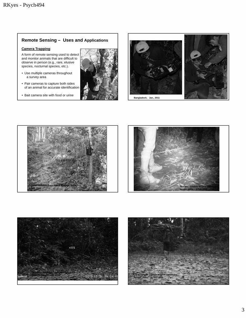
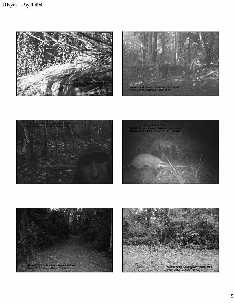
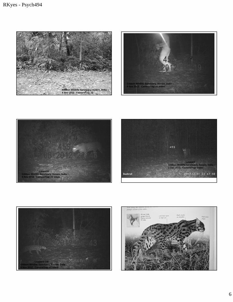
Remote Sensing – Uses and Applications
Camera Trapping:
A form of remote sensing used to detect and monitor animals that are difficult to observe in person (e.g., rare, elusive species, nocturnal species, etc.).
• Use multiple cameras throughout a survey area
• Pair cameras to capture both sides of an animal for accurate identification
• Bait camera site with food or urine Bangladesh, Jan., 2011
Gibbon Wildlife Sanctuary, Assam, India –3 Feb 2011
Tourists - Gibbon Wildlife Sanctuary, Assam, India – 3 Feb 2011
Tourists - Gibbon Wildlife Sanctuary, Assam, India – 1 Dec 2013 Local People- Gibbon Wildlife Sanctuary,
Assam, India – 30 Nov 2013

RKyes - Psych494
4
Leopard - Gibbon Wildlife Sanctuary, Assam, India – 3 Feb 2011, 10:36pm
Langtang National Park, NEPAL –21 Feb 2005
Yellow-throated Martin - Langtang National Park, Nepal – 22 Feb 2005
Langtang National Park, NEPAL –5 Feb 2012
Langtang National Park, NEPAL –5 Feb 2012
Langtang National Park, NEPAL –6 Feb 2012
RKyes - Psych494
5
PikaLangtang National Park, NEPAL –6 Feb 2012
Sulawesi Black Macaque -Tangkoko Nature Reserve, North Sulawesi, Indonesia – 6 May 2010
Sulawesi Black Macaque -Tangkoko Nature Reserve, North Sulawesi, Indonesia – 10 May 2013 Large Indian Civet
Wildlife Rescue Center, Jahangirnagar Univ., Dhaka, Bangladesh – 27 Jan 2013 ~7:30pm
Gibbon Wildlife Sanctuary, Assam, India –9 Nov 2012 CameraTraps #1 and #2
#1
#2
Gibbon Wildlife Sanctuary, Assam, India –9 Nov 2012 CameraTrap #1
RKyes - Psych494
6
Gibbon Wildlife Sanctuary, Assam, India –9 Nov 2012 CameraTrap #2
Gibbon Wildlife Sanctuary, Assam, India –9 Nov 2012 CameraTrap #1 video
LeopardGibbon Wildlife Sanctuary, Assam, India –9 Nov 2012 CameraTrap #2 video
LeopardGibbon Wildlife Sanctuary, Assam, India –1 Dec 2013 CameraTrap video
Leopard CatGibbon Wildlife Sanctuary, Assam, India –9 Nov 2012 CameraTrap #1 video
RKyes - Psych494
7
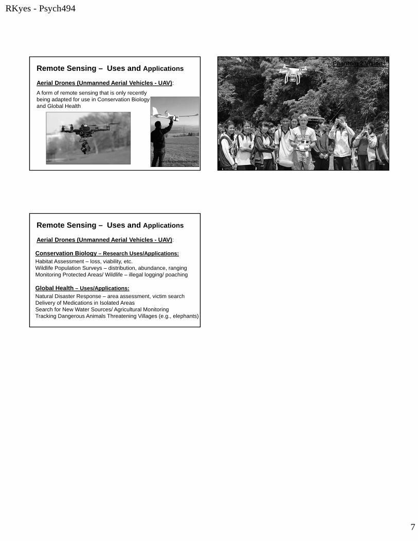
Remote Sensing – Uses and Applications
Aerial Drones (Unmanned Aerial Vehicles - UAV):
A form of remote sensing that is only recently being adapted for use in Conservation Biologyand Global Health
www.fieldandstream.com
Phantom 2 Vision+
Remote Sensing – Uses and Applications
Aerial Drones (Unmanned Aerial Vehicles - UAV):
Conservation Biology – Research Uses/Applications:
Habitat Assessment – loss, viability, etc.Wildlife Population Surveys – distribution, abundance, rangingMonitoring Protected Areas/ Wildlife – illegal logging/ poaching
Global Health – Uses/Applications:
Natural Disaster Response – area assessment, victim searchDelivery of Medications in Isolated AreasSearch for New Water Sources/ Agricultural Monitoring Tracking Dangerous Animals Threatening Villages (e.g., elephants)