QUT Digital Repository: · QUT Digital Repository: Foth, ... online chat are widespread in...
63
QUT Digital Repository: http://eprints.qut.edu.au/ Foth, Marcus and De Cindio, Fiorella (2007) Digital cities 5 : urban informatics, locative media and mobile technology in inner-city developments (Workshop). In: 3rd International Conference on Communities and Technologies, 28-30 June 2007, East Lansing, MI, USA. © Copyright 2007 Springer
Transcript of QUT Digital Repository: · QUT Digital Repository: Foth, ... online chat are widespread in...
QUT Digital Repository: http://eprints.qut.edu.au/
Foth, Marcus and De Cindio, Fiorella (2007) Digital cities 5 : urban informatics,
locative media and mobile technology in inner-city developments (Workshop). In:
3rd International Conference on Communities and Technologies, 28-30 June 2007,
East Lansing, MI, USA.
© Copyright 2007 Springer
ConferenceWorkshopProceedings
DigitalCities5:UrbanInformatics,LocativeMediaandMobileTechnologyinInner‐CityDevelopmentsWorkshopheldinconjunctionwithC&T2007
28thJune2007,MichiganStateUniversity,EastLansing,MI,USA
Workshoporganisers,andeditorsoftheproceedings• MarcusFoth,QueenslandUniversityofTechnology,Brisbane,Australia• FiorellaDeCindio,UniversitàdegliStudidiMilano,Italy
Acceptedpapers• seenextpage
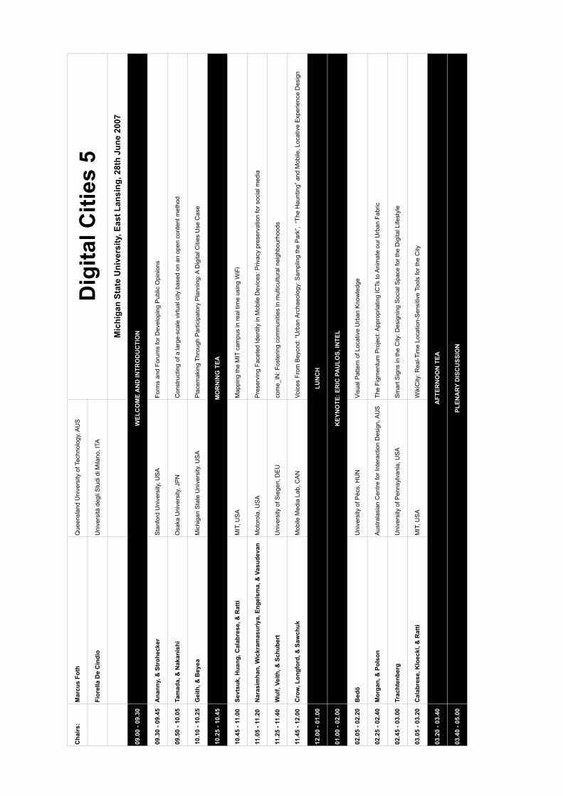
Cha
irs:
Mar
cus
Foth
Que
ensl
and
Uni
vers
ity o
f Tec
hnol
ogy,
AU
S
Fior
ella
De
Cin
dio
Uni
vers
ità d
egli
Stu
di d
i Mila
no, I
TA
Mic
higa
n St
ate
Uni
vers
ity, E
ast L
ansi
ng, 2
8th
June
200
7
09.0
0 - 0
9.30
09.3
0 - 0
9.45
Ana
nny,
& S
troh
ecke
rS
tanf
ord
Uni
vers
ity, U
SA
Form
s an
d Fo
rum
s fo
r Dev
elop
ing
Pub
lic O
pini
ons
09.5
0 - 1
0.05
Tam
ada,
& N
akan
ishi
Osa
ka U
nive
rsity
, JP
NC
onst
ruct
ing
of a
larg
e-sc
ale
virtu
al c
ity b
ased
on
an o
pen
cont
ent m
etho
d
10.1
0 - 1
0.25
Gei
th, &
Bey
eaM
ichi
gan
Sta
te U
nive
rsity
, US
AP
lace
mak
ing
Thro
ugh
Par
ticip
ator
y P
lann
ing:
A D
igita
l Citi
es U
se C
ase
10.2
5 - 1
0.45
10.4
5 - 1
1.00
Sevt
suk,
Hua
ng, C
alab
rese
, & R
atti
MIT
, US
AM
appi
ng th
e M
IT c
ampu
s in
real
tim
e us
ing
WiF
i
11.0
5 - 1
1.20
Nar
asim
han,
Wic
kram
asur
iya,
Eng
elsm
a, &
Vas
udev
anM
otor
ola,
US
AP
rese
rvin
g Fa
cete
d Id
entit
y in
Mob
ile D
evic
es: P
rivac
y pr
eser
vatio
n fo
r soc
ial m
edia
11.2
5 - 1
1.40
Wul
f, Ve
ith, &
Sch
uber
tU
nive
rsity
of S
iege
n, D
EU
com
e_IN
: Fos
terin
g co
mm
uniti
es in
mul
ticul
tura
l nei
ghbo
urho
ods
11.4
5 - 1
2.00
Cro
w, L
ongf
ord,
& S
awch
ukM
obile
Med
ia L
ab, C
AN
Voic
es F
rom
Bey
ond:
“Urb
an A
rcha
eolo
gy: S
ampl
ing
the
Par
k”,
“The
Hau
ntin
g” a
nd M
obile
, Loc
ativ
e E
xper
ienc
e D
esig
n
12.0
0 - 0
1.00
01.0
0 - 0
2.00
02.0
5 - 0
2.20
Bed
öU
nive
rsity
of P
écs,
HU
NVi
sual
Pat
tern
of L
ocat
ive
Urb
an K
now
ledg
e
02.2
5 - 0
2.40
Mor
gan,
& P
olso
nA
ustra
lasi
an C
entre
for I
nter
actio
n D
esig
n, A
US
The
Figm
entu
m P
roje
ct: A
ppro
pria
ting
ICTs
to A
nim
ate
our U
rban
Fab
ric
02.4
5 - 0
3.00
Trac
hten
berg
Uni
vers
ity o
f Pen
nsyl
vani
a, U
SA
Sm
art S
igns
in th
e C
ity: D
esig
ning
Soc
ial S
pace
for t
he D
igita
l Life
styl
e
03.0
5 - 0
3.20
Cal
abre
se, K
loec
kl, &
Rat
tiM
IT, U
SA
Wik
iCity
: Rea
l-Tim
e Lo
catio
n-S
ensi
tive
Tool
s fo
r the
City
03.2
0 - 0
3.40
03.4
0 - 0
5.00
KEY
NO
TE: E
RIC
PA
ULO
S, IN
TEL
AFT
ERN
OO
N T
EA
PLEN
ARY
DIS
CU
SSIO
N
Dig
ital C
ities
5
WEL
CO
ME
AN
D IN
TRO
DU
CTI
ON
MO
RN
ING
TEA
LUN
CH
1
Digital Cities 5: Urban Informatics, Locative Media and Mobile Technology in Inner-City Developments
Marcus Foth, Queensland University of Technology, Brisbane, Australia, [email protected]
Fiorella De Cindio, Università degli Studi di Milano, Italy, [email protected]
1 Workshop Theme Many new urban developments are systematically planned and rapidly built and marketed, trying to create
instant ‘communities’ in dense concentrations. In Hong Kong for example, new high-rise residential
developments create concentrations of up to 10,000 people per apartment precinct (Forrest et al., 2002).
Developers and governments around the world struggling to achieve socially sustainable neighbourhood
communities in these urban contexts are increasingly considering the role of new media and information and
communication technology (ICT). Conventional community technology (such as portals and intranets) do not
work by themselves, mainly because they assume a ‘collective’ approach to building community and neglect
the social structures that emerge from fluid social networks (Arnold et al., 2003; Foth, 2006a, 2006b; Foth &
Hearn, 2007, forthcoming; Hopkins, 2005). Instead of a collective approach, the ecology of social networks
and their digital augmentation in the context of inner-city urban developments is the focus of this workshop.
Mobile phones and internet-based communication technologies such as email, instant messengers and
online chat are widespread in cities. A number of studies provide evidence that they have become integrated
into the everyday life of many people (e.g., Boase et al., 2006; Fallows, 2004). The ability to communicate
selectively, mediated, relayed and over distance impacts on the way social relationships are constructed and
maintained. Recent studies show that social relationships that originate from online interaction are taken into
and continued in the offline world and vice versa (Hampton, 2004; Mesch & Levanon, 2003). Castells (2001)
thus speaks of ‘portfolios of sociability’ to describe the interwoven networks of kinship, friends and peers
people create which offer a set of new qualities to the concept of ‘community’. Wellman (2001) too has
recognised the hybridity of groups and networks in the notion of community and the new dimensions added
by new media which he describes with the term ‘networked individualism’.
In this context, personalised mobile devices penetrate new urban spaces with a need for innovative products
and services that enable the creative and consumption process to account for shifting social, cultural and
psychological conditions. City residents now have the ability to communicate within groups, access media
and entertainment content and manage their ‘digital lifestyle’ through SMS, mobile email, pictures and video.
These innovative applications of locative media incorporate cultural and social patterns of interaction and
user-led innovations that are yet to be fully explored. In addition to these informational and locative functions
of new technologies, ICTs increasingly serve a discursive function as well. This is being manifested in a
variety of rapidly emerging content genres (e.g., digital storytelling, blogs, e-zines, etc.) which are deployed
between individuals as well as in networks of individuals (Matei & Ball-Rokeach, 2003). Digital cities have
been promoted as a civic platform for citizens’ visions of the space they live and work in, complementary
(and sometimes even alternative) to the much more institutional view of conventional e-government
approaches. Locative media and mobile technology can enhance and augment digital cities and connect
them in new ways to the physical city (Rheingold, 2002), enhancing civic participation and deliberation (De
Cindio et al., 2006; Kavanaugh et al., 2005).

2
Relevant Research Questions:
• How can a balance be achieved between the opportunities of locative media and mobile technology on
the one side and issues of access, trust and privacy on the other?
• What is the role of locally relevant content (personal and community images and narratives) in the
establishment of sustainable social networks as well as in the context of civic participation?
• What can we learn from the communication models of global social networking sites such as MySpace
and plazes.com in order to animate local interaction and civic participation of residents and friends
locally?
• What is the role of location, (geo)graphical representations such as maps of various kinds, in supporting
people to understand and navigate the augmented urban landscape?
• What is the impact of these new technologies on the challenges in moving from e-government to e-
governance, e-participation to e-democracy at the urban level? Will these technological developments
help increase or decrease the opportunities for citizens to play a role in shaping sustainable cities?
• What are the implications for the architecture and urban design of cities and public spaces?
2 Activities and Goals • Bring together leading researchers at the intersection of people, place and technology.
• Publish selected workshop papers in Foth, M. (Ed.). (2008). Urban Informatics: Community Integration
and Implementation. Hershey, PA: Idea Group. Revised chapters for this book are due early October
2007. Details will be made available to workshop presenters.
• Continue the successful “Digital Cities” series of workshops which have resulted in these publications:
Aurigi, A., & De Cindio, F. (Eds.). (2007, forthcoming). Augmented Urban Spaces: Articulating the Physical
and Electronic City. Aldershot, UK: Ashgate.
van den Besselaar, P., & Koizumi, S. (Eds.). (2005). Digital Cities 3: Information Technologies for Social
Capital: Cross-cultural Perspectives. Third International Digital Cities Workshop, Amsterdam, The
Netherlands, September 18-19, 2003. Revised Selected Papers (Lecture Notes in Computer Science No.
3081). Heidelberg, Germany: Springer.
Tanabe, M., van den Besselaar, P., & Ishida, T. (Eds.). (2002). Digital Cities 2: Computational and
Sociological Approaches (Lecture Notes in Computer Science No. 2362). Heidelberg, Germany: Springer.
Ishida, T., & Isbister, K. (Eds.). (2000). Digital Cities: Technologies, Experiences, and Future Perspectives
(Lecture Notes in Computer Science No. 1765). Heidelberg, Germany: Springer.
3 Background and Significance The lack of viable systems designed to facilitate and support social networking in inner-city residential
developments presents an immediate opportunity to create innovative solutions to bridge this gap (Foth,
2006b). The practical significance of this study examining place-based social networking systems is
therefore threefold: First, existing groupware solutions (e.g. from Computer Supported Cooperative Work
approaches) can at best only be re-appropriated for use in social and urban environments, because the
3
original scope of application is regularly limited to business contexts. This substantiates a need to design
purpose-built solutions that are customised for specific usage in a social, place-based milieu. Secondly, the
ubiquity of new media and ICT is drawing attention to a hybrid notion of ‘community’ that is both networked
and individualistic at the same time. This has direct repercussions for creating appropriate conceptual
models of socio-cultural interaction to aid the design and development of innovative social networking and
civic participation systems. Thirdly, in the case of interaction systems for geographically proximate urban
dwellers, the focus is on local interaction which presents significant challenges and opportunities with
regards to location-awareness, privacy, security, identity, presence, and social control. Research to date into
these fast-paced and cross-disciplinary areas has not been exhaustive.
The workshop is also significant for its focus on the emerging social needs of citizens living in increasingly
dense cities. For example, Australia is one of the most urbanised countries in the world in terms of the high
proportion of urban dwellers among its total population. Approximately two-thirds of the total population
reside in major cities (Australian Bureau of Statistics, 2004). Current projections for South East Queensland
(SEQ) are 3.71m residents by 2026, an increase of around 1.05m people, or almost 50k each year on
average (Queensland Government, 2005, p. 5). The continuation of the low density urban sprawl in SEQ is
not sustainable. These trends (similar in other areas elsewhere in Australia and the world) have global
economic relevance and reflect the changing role of cities internationally. Compact city policies are being
developed and implemented in all Australian capitals to deal with population pressures and urban expansion.
As a result, as Randolph (2004, p. 483) argues, “the language of community has come back with vengeance
in policy areas that ignored it for many years. Cities are becoming, perhaps more than ever before,
collections of distinctive communities and neighbourhoods, all the more differentiated as the cities grow in
size and complexity. As the city expands, people remain focused on their small part of it”. The strategies
proposed in these policies open up new research questions around issues of living together creatively and
population diversity, which are the focus of this workshop.
The significance of this workshop is also evident in the stark contrast between the rapid development and
uptake of 3G and ‘next-G’ mobile technology and the lack of socio-culturally meaningful local content
solutions and applications available for them. New generation mobile phones can store 5,000 songs, 90
minutes of video, receive radio and television broadcasts, and have mobile email and internet. The growing
social, cultural and economic impact of locative media solutions will take on greater significance in the social
and cultural life of city dwellers as the major carriers commit to 3G technology and look for appropriate social
and local services and content over the next three years.
4 Organisation and Submission Details This is a full day workshop (8 hours) including one keynote address and approx. 10 to 12 paper presenters
(20 min each including Q&A and hand-over) followed by a plenary discussion at the end. The workshop can
accommodate a maximum number of approx. 25 to 30 participants including presenters in order to provide
an environment that stimulates debate and interaction.
We are interested in three types of contributions:
• Concepts: Papers which examine the prevalent zeitgeist, discuss theoretical and conceptual
innovation within a cross-disciplinary framework.
4
• Methods: Papers which report on novel approaches in the area of urban informatics, e.g. network
action research, visual ethnography, probes, etc.
• Cases: Reports of case studies which provide empirical data to ground their findings in practice.
Interested contributors should submit an extended abstract, 1500-2000 words long, stating the
author’s name, affiliation, and contact information. This should be emailed to the workshop organisers before April 16th, 2007 and should summarise the author(s) research / practice
background and interests as well as the work and results that will be described in a full paper. Accepted authors will be notified by May 18th, 2007. The acceptance of an extended abstract implies that at
least one of the authors will register for both the workshop and the Communities & Technologies 2007
conference. Selected contributors will be asked to submit a full paper before October 1st, 2007. Full papers
will undergo double blind peer review and appear in an edited book to be published by Idea Group in 2008.
Please email any questions and inquiries to both workshop organisers.
5 Contact Marcus Foth is an Australian Postdoctoral Fellow with the Institute for Creative Industries and Innovation at
Queensland University of Technology (QUT), Brisbane, Australia. His research pioneers new development
approaches toward interactive social networking systems informed by community, social, and urban studies,
and employs human-centered and participatory design methods. Foth received a PhD in digital media and
urban sociology from QUT. He is a member of the Australian Computer Society and the Australian
Interactive Media Industry Association. His online resume and portfolio is available at www.vrolik.de.
Fiorella De Cindio is Associate Professor at the Computer and Information Science Department of the
University of Milan where she teaches and carries out research on Distributed Systems Design, Online
Communities and e-democracy. In 1994 she promoted the Civic Informatics Laboratory (LIC), of which she
has been the director since then and, in this role, set up the Milan Community Network RCM, which is now a
Participatory Foundation. She also promoted the Association for Informatics and Civic Networking of
Lombardy (A.I.Re.C.) which groups the Community Networks in the Lombardy Region. Fiorella is now
President of both. In December 2001 she received the ‘Ambrogino d’Oro’, the civic top award assigned by
the Milan Municipality to citizens who have contributed to city development.
6 References Arnold, M., Gibbs, M. R., & Wright, P. (2003). Intranets and Local Community: 'Yes, an intranet is all very well, but do we
still get free beer and a barbeque?' In M. Huysman, E. Wenger & V. Wulf (Eds.), Proceedings of the First International Conference on Communities and Technologies (pp. 185-204). Amsterdam, NL: Kluwer.
Australian Bureau of Statistics. (2004). Year Book Australia: Population. Article: How many people live in Australia's remote areas? (No. 1301.0). Canberra, ACT: Australian Bureau of Statistics.
Boase, J., Horrigan, J. B., Wellman, B., & Rainie, L. (2006). The Strength of Internet Ties. Washington, DC: Pew Internet & American Life Project.
Castells, M. (2001). Virtual Communities or Network Society? In The Internet Galaxy: Reflections on the Internet, Business, and Society (pp. 116-136). Oxford: Oxford University Press.
De Cindio, F., De Marco, A., & Sonnante, L. (2006, Oct 16). Enriching Community Networks by Supporting Deliberation. Paper presented at the DEMOnet Workshop on eDeliberation Research, Leeds, UK.
Fallows, D. (2004). The Internet and Daily Life. Washington, DC: Pew Internet & American Life Project. Forrest, R., La Grange, A., & Mgai-Ming, Y. (2002). Neighbourhood in a high-rise high density city: Some observations
on contemporary Hong Kong (Working Paper). Bristol, UK: ESCR Centre for Neighbourhood Research, Bristol. Foth, M. (2006a). Analyzing the Factors Influencing the Successful Design and Uptake of Interactive Systems to Support
Social Networks in Urban Neighborhoods. International J of Technology and Human Interaction, 2(2), 65-79. Foth, M. (2006b). Facilitating Social Networking in Inner-City Neighborhoods. IEEE Computer, 39(9), 44-50.

5
Foth, M., & Hearn, G. (2007, forthcoming). Networked Individualism of Urban Residents: Discovering the Communicative Ecology in Inner-City Apartment Complexes. Information, Communication & Society.
Hampton, K. N. (2004). Networked sociability online, off-line. In M. Castells (Ed.), The Network Society: A Cross-cultural perspective (pp. 217-232). Northampton, MA: Edward Elgar Publishing.
Hopkins, L. (2005). Making a Community Network Sustainable: The Future of the Wired High Rise. The Information Society, 21(5), 379-384.
Kavanaugh, A. L., Isenhour, P. L., Cooper, M., Carroll, J. M., Rosson, M. B., & Schmitz, J. (2005). Information Technology in Support of Public Deliberation. In P. v. d. Besselaar, G. De Michelis, J. Preece & C. Simone (Eds.), Proceedings Communities and Technologies 2005 (pp. 19-40). Dordrecht, NL: Springer.
Matei, S. A., & Ball-Rokeach, S. J. (2003). The Internet in the Communication Infrastructure of Urban Residential Communities: Macro- or Mesolinkage? Journal of Communication, 53(4), 642-657.
Mesch, G. S., & Levanon, Y. (2003). Community Networking and Locally-Based Social Ties in Two Suburban Localities. City and Community, 2(4), 335-351.
Queensland Government. (2005). South East Queensland Regional Plan 2005 - 2026. Brisbane, QLD: Office of Urban Management, Department of Local Government, Planning, Sport and Recreation.
Randolph, B. (2004). The Changing Australian City: New Patterns, New Policies and New Research Needs. Urban Policy and Research, 22(4), 481-493.
Rheingold, H. (2002). Smart Mobs: The Next Social Revolution. Cambridge, MA: Perseus.
Submission to Digital Cities 5:
Urban Informatics, Locative Media and Mobile Technology in Inner-City Developments
Workshop at the 3rd International Conference on Communities and Technologies
June 28th, 2007, Michigan State University, East Lansing, MI, USA
-- EXTENDED ABSTRACT --
Title:
Forms and Forums for Developing Public Opinions
Authors:
Mike Ananny [author for correspondence]
Department of Communication
Stanford University
Carol Strohecker
Center for Design Innovation
University of North Carolina
Introduction
Public forums, polls and elections are traditional ways of sampling and representing public
opinion. They seldom acknowledge, however, that developing a perspective on an issue of social
concern is a kind of learning that depends on public exchanges as well as private deliberations. In
this paper we present the design, installation and analysis of a different kind of public discourse
forum – TexTales – created with groups of European young people, which casts public opinions
as epistemological developments emerging from interplays between individual and collaborative
expressions.
TexTales
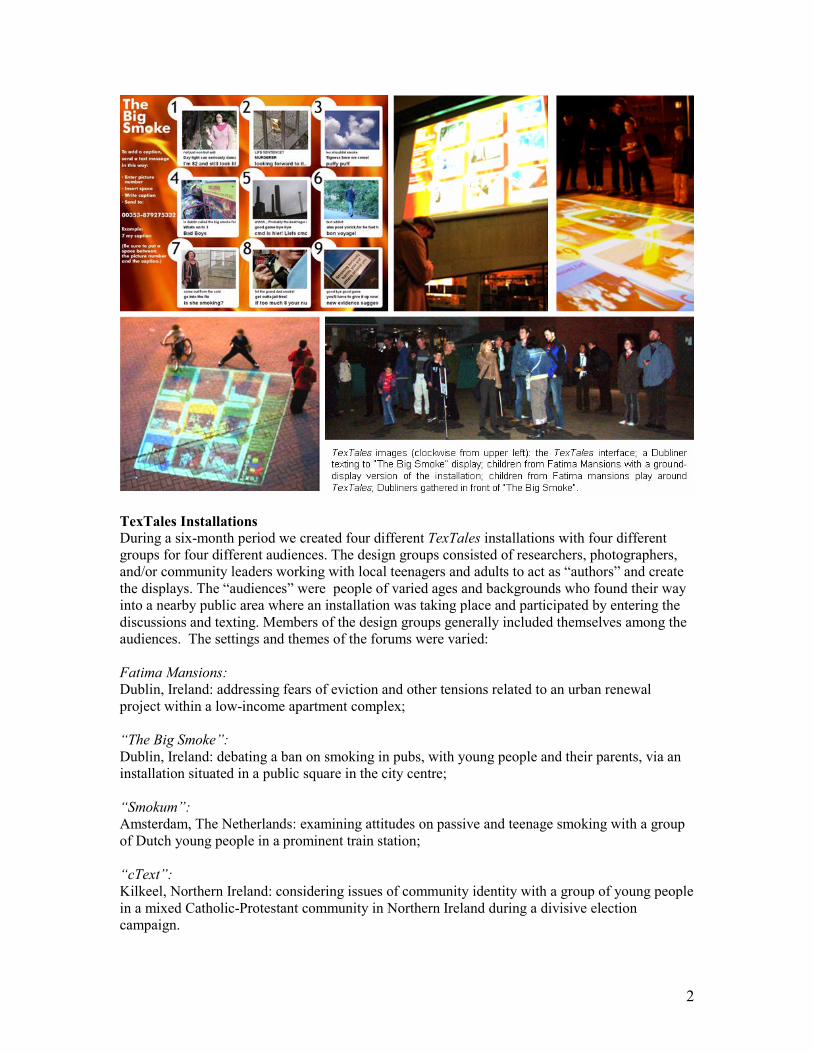
TexTales is a large-scale interactive projection designed to support multimodal dialogue among
crowds in public places. A TexTales display consists of a grid of nine photographs, with three
captions under each image. Passers-by create the captions by sending short messaging service
(SMS) text messages from their mobile phones
Contributors compose captions by deciding what picture to augment and entering its number
along with the text. Moments after sending the message, the display refreshes and shows the new
caption It appears at the bottom of the set of three, bumping the oldest from the top as the other
two lines scroll upwards. This dynamic effect engages additional passers-by, who quickly
understand themselves to be co-creators of the display. As participants continue to initiate
captions and respond to some already there, people linger. Some of their discussion plays out
among the crowd and some on the display, for all to see. Meanwhile the TexTales system stores
and indexes all texts by time, date, phone number from which the text was sent and display
number of the associated image.
2
TexTales Installations
During a six-month period we created four different TexTales installations with four different
groups for four different audiences. The design groups consisted of researchers, photographers,
and/or community leaders working with local teenagers and adults to act as “authors” and create
the displays. The “audiences” were people of varied ages and backgrounds who found their way
into a nearby public area where an installation was taking place and participated by entering the
discussions and texting. Members of the design groups generally included themselves among the
audiences. The settings and themes of the forums were varied:
Fatima Mansions:
Dublin, Ireland: addressing fears of eviction and other tensions related to an urban renewal
project within a low-income apartment complex;
“The Big Smoke”:
Dublin, Ireland: debating a ban on smoking in pubs, with young people and their parents, via an
installation situated in a public square in the city centre;
“Smokum”:
Amsterdam, The Netherlands: examining attitudes on passive and teenage smoking with a group
of Dutch young people in a prominent train station;
“cText”:
Kilkeel, Northern Ireland: considering issues of community identity with a group of young people
in a mixed Catholic-Protestant community in Northern Ireland during a divisive election
campaign.

3
The installations differed in content, authors and audience but we employed a general process for
designing each:
• Establish a collaboration with a group interested in creating an installation in their
neighborhood and give an initial demo of the TexTales interface.
• Work with a group of citizens, artists and community leaders (e.g. photojournalists, youth
workers) to decide the installation’s focus, setting and audience.
• During several weeks’ collaboration, create images and texts for the installation and plan
logistics.
• Advertise the installation and present it in a public venue, encouraging broad
participation.
• After the installation, reconvene to reflect upon results and plan future engagements or
improvements.
We developed two kinds of analysis that help us to understand this transformation of everyday
mobile phones into tools for learning.
In our discourse analysis we analyze participants’ public texts and images for thematic patterns,
investigating how participants expressed their opinions through TexTales messages and images.
This analysis focuses on how participants in the “Smokum” installation expressed their
perspectives on second-hand smoking, identifying four types of views of smoking:
• smoking as a social activity;
• smoking as an age-related activity;
• smoking as risk-taking behaviour;
• smoking as regulated behaviour.
In our interaction design analysis we describe participants’ uses of the system in terms of four
practices:
• starting “intermodal” conversations;
• authoring for nomadic, unfamiliar audiences;
• interplaying between public and private, individual and collaborative messaging;
• and framing, editing and censoring dialogue.
We review how these patterns and ways of engaging both reflect and support expression of public
opinions. We also describe how they are contributing to our understanding of tools and spaces for
developing public opinions.
Our broad aim in this project is to determine how citizen-authored media (in this case images and
texts) can become “objects to think with” (Papert, 1991).How might they enjoy the same status in
public debates as more abstract notions? How can they demonstrate roles that diverse, socially
constructed media may have in representing and developing public opinions? The four TexTales
installations reveal suggest how we might co-design forms and forums for expressing and
developing public opinions.
By forms we mean the representations that personal and public expressions take as people
construct opinions. In the case of the TexTales installations, the expressions took form in the
photographs people captured, edited and arranged as they interpreted a particular topic or issue; in
the three-by-three image template that we as designers provided; in the SMS captions people
4
created for the images as they participated in the installations; and in the informal conversations
people had as they viewed the projected image-text combinations and discussed their particular
contributions. We also refer to people's uses of relations among these forms to create complex
representations.
By forums we mean the settings and contexts in which people use the forms in particular
processes of constructing opinions. In the case of TexTales, there were multiple forums,
sometimes co-existing at a particular time:
• the initial workshops in which the designers and authors became acquainted with each
other and the TexTales technology, and discussed different photojournalistic and
communicative techniques that they would use to produce their particular installation;
• the on-going critiques of images and issues that arose as people met repeatedly to design
their installations;
• the social spaces of the projections and the ways in which the participant-designers and
the general public came together to experiment with a projections and to explain and
discuss the designs and goals of the installations;
• finally – and least explored thus far – the ongoing contexts in which participant-designers
and the general public may continue to discuss and think about the issues and opinions
they encountered during TexTales installations.
We have described here a set of technology-supported environments in which public opinion is
treated as a socially situated, developmental process. We have focused on tensions inherent in
personal expressions in public spaces, shifts among individual and collective scales of opinion
and public opinions that result from people’s [deliberatively and socially] constructed
expressions, rather than from sampled responses. We would need further work, such as
longitudinal case studies, in order to describe more conclusively the exact nature of our
participants’ public opinions or how those opinions may have evolved.
[Word count: 1164]
Constructing of a large-scale virtual city based on an open content method Daisuke Tamada Hideyuki Nakanishi
Department of Adaptive Machine Systems, Osaka University 2-1 Yamadaoka, Suita, Osaka 565-0871, Japan
Phone: +81-6-6879-4182 Fax: +81-6-6879-4180
Email: {daisuke.tamada, nakanishi}@ams.eng.osaka-u.ac.jp
1. Introduction Virtual globe services, such as Google Maps and Microsoft Virtual Earth, have recently become popular. Most virtual globe services use aerial or satellite photos. Consequently, those services can show users only the roofs of buildings in a city. Instead of photos taken from the sky, our virtual city system uses photos taken from the pedestrians’ or drivers’ viewpoint. These photos include richer information about the urban scenery than aerial or satellite photos. There are some virtual city systems similar to our service [Shenchang 1995; Koizumi 2003; Snavely 2006]. However, those systems cover only specific areas, like the center of capital cities and famous historic places, since it is not very cost-effective to collect photos that capture the side views of buildings.
This paper proposes a kind of “open content method” as the most promising way to construct a large-scale virtual city. This method relies on people who voluntarily take pictures of urban areas using cellular phones equipped with GPS. We developed a server-side system that receives these pictures from users, adjusts the pictures’ position and orientation, and finally synthesizes them to generate a virtual city. The rest of the paper discusses the pros and cons of our method by comparison with conventional methods, and also describes the results of an initial test to use our implemented prototype.
2. Conventional Methods A common way to make virtual cities is manual 3D modeling [Takase 2005]. That is obviously very costly. Image-based rendering methods can automatically concatenate photo images and generate a panoramic view [Shenchang 1995; Koizumi 2003]. This method does not require manual modeling but requires manual collection of a large number of photos. The “open content method” may be the best possible solution to this problem. One of the systems based on the method is the “Photo tourism” system [Snavely 2006]. This system is able to automatically make a panoramic view from photos accumulated at a website that provides a photo sharing service. However, this method works only in situations where many people voluntarily take pictures of the same buildings or objects, since the method employs image processing that needs a sufficient amount of overlapping area between each photo. Another system based on the “open content method” is the “Balog” system [Uematsu 2004]. When a user takes a picture using a cellular phone equipped with GPS and sends it to the system, the system places the photo image on the map based on the attached position data. This method can be applied to uninteresting urban areas where a
small number of users take pictures sparsely. However, the resulting product, in which photo images are simply pasted onto the map, does not provide geographically consistent scenery.
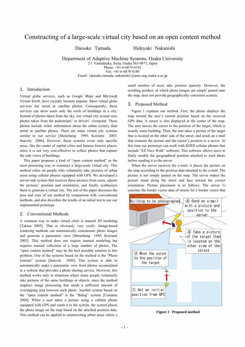
3. Proposed Method Figure 1 explains our method. First, the phone displays the
map around the user’s current position based on the received GPS data. A cursor is also displayed at the center of the map. The user moves the cursor to the position of the target, which is usually some building. Then, the user takes a picture of the target that is located on the other side of the street, and sends an e-mail that contains the picture and the cursor’s position to a server. At this time our prototype can work with KDDI cellular phones that include “EZ Navi Walk” software. This software allows users to freely modify the geographical position attached to each photo before sending it to the server.
When the server receives the e-mail, it places the picture on the map according to the position data attached to the e-mail. The picture is not simply pasted on the map. The server makes the picture stand along the street and face toward the correct orientation. Picture placement is as follows: The server 1) searches the border vector data of streets for a border vector that
Figure 1 Proposed method
- 1 -
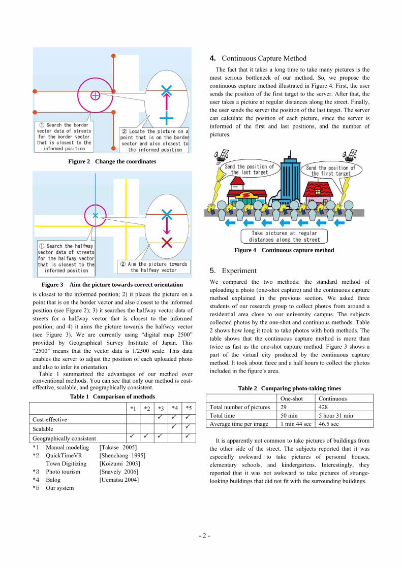
Figure 2 Change the coordinates
is closest to the informed position; 2) it places the picture on a point that is on the border vector and also closest to the informed position (see Figure 2); 3) it searches the halfway vector data of streets for a halfway vector that is closest to the informed position; and 4) it aims the picture towards the halfway vector (see Figure 3). We are currently using “digital map 2500” provided by Geographical Survey Institute of Japan. This “2500” means that the vector data is 1/2500 scale. This data enables the server to adjust the position of each uploaded photo and also to infer its orientation.
Table 1 summarized the advantages of our method over conventional methods. You can see that only our method is cost-effective, scalable, and geographically consistent.
Table 1 Comparison of methods
*1 *2 *3 *4 *5
Cost-effective
Scalable Geographically consistent
4. Continuous Capture Method The fact that it takes a long time to take many pictures is the
most serious bottleneck of our method. So, we propose the continuous capture method illustrated in Figure 4. First, the user sends the position of the first target to the server. After that, the user takes a picture at regular distances along the street. Finally, the user sends the server the position of the last target. The server can calculate the position of each picture, since the server is informed of the first and last positions, and the number of pictures.
Figure 4 Continuous capture method
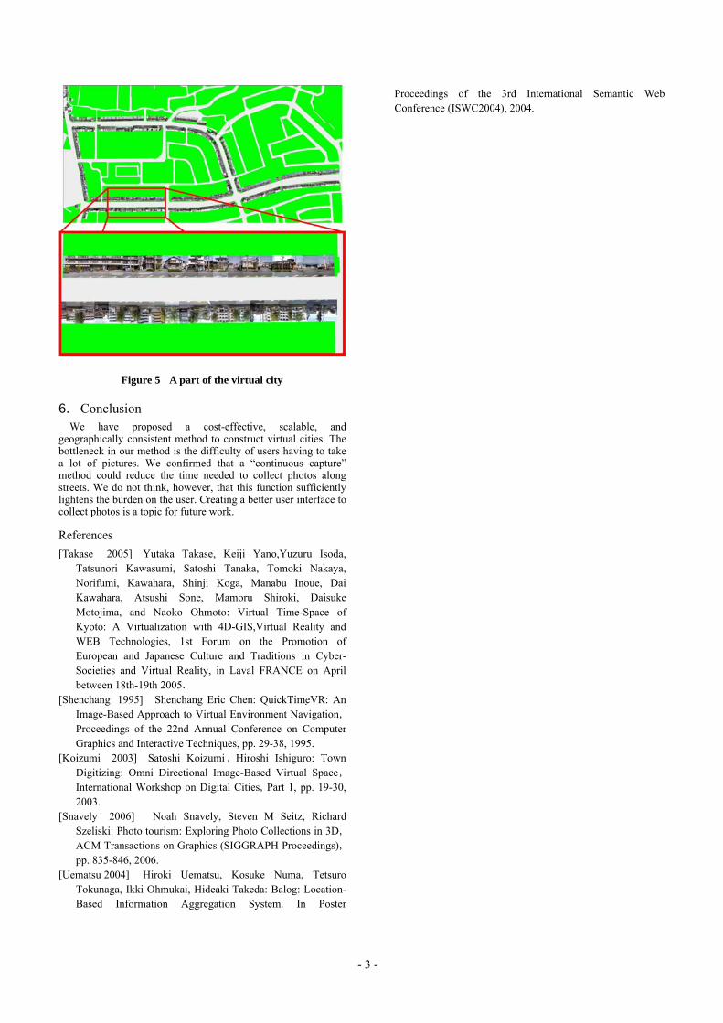
5. Experiment We compared the two methods: the standard method of uploading a photo (one-shot capture) and the continuous capture method explained in the previous section. We asked three students of our research group to collect photos from around a residential area close to our university campus. The subjects collected photos by the one-shot and continuous methods. Table 2 shows how long it took to take photos with both methods. The table shows that the continuous capture method is more than twice as fast as the one-shot capture method. Figure 3 shows a part of the virtual city produced by the continuous capture method. It took about three and a half hours to collect the photos included in the figure’s area.
Figure 3 Aim the picture towards correct orientation
Table 2 Comparing photo-taking times
One-shot Continuous Total number of pictures 29 428 Total time 50 min 5 hour 31 min Average time per image 1 min 44 sec 46.5 sec
It is apparently not common to take pictures of buildings from the other side of the street. The subjects reported that it was especially awkward to take pictures of personal houses, elementary schools, and kindergartens. Interestingly, they reported that it was not awkward to take pictures of strange-looking buildings that did not fit with the surrounding buildings.
*1 Manual modeling [Takase 2005] *2 QuickTimeVR [Shenchang 1995]
Town Digitizing [Koizumi 2003] *3 Photo tourism [Snavely 2006] *4 Balog [Uematsu 2004] *5 Our system
- 2 -
6. Conclusion We have proposed a cost-effective, scalable, and
geographically consistent method to construct virtual cities. The bottleneck in our method is the difficulty of users having to take a lot of pictures. We confirmed that a “continuous capture” method could reduce the time needed to collect photos along streets. We do not think, however, that this function sufficiently lightens the burden on the user. Creating a better user interface to collect photos is a topic for future work.
References [Takase 2005] Yutaka Takase, Keiji Yano,Yuzuru Isoda,
Tatsunori Kawasumi, Satoshi Tanaka, Tomoki Nakaya, Norifumi, Kawahara, Shinji Koga, Manabu Inoue, Dai Kawahara, Atsushi Sone, Mamoru Shiroki, Daisuke Motojima, and Naoko Ohmoto: Virtual Time-Space of Kyoto: A Virtualization with 4D-GIS,Virtual Reality and WEB Technologies, 1st Forum on the Promotion of European and Japanese Culture and Traditions in Cyber-Societies and Virtual Reality, in Laval FRANCE on April between 18th-19th 2005.
[Shenchang 1995] Shenchang Eric Chen: QuickTimeVR: An Image-Based Approach to Virtual Environment Navigation,
Proceedings of the 22nd Annual Conference on Computer Graphics and Interactive Techniques, pp. 29-38, 1995.
[Koizumi 2003] Satoshi Koizumi , Hiroshi Ishiguro: Town Digitizing: Omni Directional Image-Based Virtual Space,
International Workshop on Digital Cities,Part 1, pp. 19-30, 2003.
[Snavely 2006] Noah Snavely, Steven M Seitz, Richard Szeliski: Photo tourism: Exploring Photo Collections in 3D,
ACM Transactions on Graphics (SIGGRAPH Proceedings),pp. 835-846, 2006.
[Uematsu 2004] Hiroki Uematsu, Kosuke Numa, Tetsuro Tokunaga, Ikki Ohmukai, Hideaki Takeda: Balog: Location-Based Information Aggregation System. In Poster
Proceedings of the 3rd International Semantic Web Conference (ISWC2004), 2004.
Figure 5 A part of the virtual city
- 3 -
Digital Cities 5 Workshop Placemaking Through Participatory Planning: A Digital Cities Use Case Christine Geith, Michigan State University The problem: Citizens are frustrated and ill-informed about the changes taking place in their communities. Most community land use decisions effectively leave citizens out of the process. Most plans fail because members of the community are not actively engaged in the process. The problem for citizens is twofold: (1) they don't have good tools to support their learning; and (2) they are dispersed and fragmented—groups of citizens in different communities likely face similar problems and have similar needs but it is currently difficult for them to share. The stakeholders and their roles in the solution:
• Community members – Participate in, and influence, land-use decisions that shape their communities.
• Elected officials- Engage and respond to citizen ideas and concerns regarding physical changes to their community.
• Journalists-Provide the network for investigative local reporting. • Developers- Understand and address important place making considerations
before submitting local development proposals and revisions based on citizen ideas.
• Non-profits- Share relevant information and mobilize their constituents including: land conservation groups, neighborhood associations, community action agencies, etc.
• Professional Community Planners- Inform citizen groups with relevant data and development proposals to enhance citizen participation.
What are the solutions? Putting into practice Digital Cities research, how can we create collective intelligence and generate persuasive knowledge to empower citizens – agents of change? What kinds of information tools enable citizens to shape what their communities look like? In what ways can we enable citizens to contribute to, and investigate, relevant information and hold public officials accountable? How can we use community data, locative media and social software to enable effective local action? The Citizen Planner program of Michigan State University’s Land Policy Institute is home to the first online program for citizen land-use decisionmakers. Using its extensive research into land use issues and the information and learning needs of planning officials, the Institute helps citizens have a voice in local land-use decisions. How can we put into practice the knowledge of Digital Cities researchers to impact local planning decisions?
Mapping the MIT campus in real time using WiFi Andres Sevtsuk, Sonya Huang, Francesco Calabrese, Carlo Ratti SENSEable City Laboratory, MIT 10-485, 77 Massachusetts Avenue, Cambridge, MA 02139, USA Contact e-mail: {asevtsuk, sonya, fcalabre, ratti} @mit.edu Abstract This paper presents the iSPOTS project, which collects and maps data of WiFi usage on the Massachusetts Institute of Technology campus. Instead of simply mapping the locations of WiFi availability, the project is possibly first to use and analyze log files from the Institute’s Internet service provider and to produce spatial visualizations of the observed activity in real time. The aim is to create a better understanding of the daily working/living patterns of the MIT academic community, which is being changed due to the emergence of WiFi itself. The MIT wireless IEEE 802.11 network consisting of 3,000 access points, one of the largest of its kind, offers a privileged environment for this research and, in perspective, can provide a test bed for entire cities. Keywords: wireless mapping, Geographic Information Systems, urban dynamics, wireless Internet, WiFi, IEEE 802.11, university campus, Massachusetts Institute of Technology. 1. Introduction Recent years have witnessed a great increase in wireless Internet access points (WiFi hotspots) in cities around the world. At the time of writing this paper in December 2006, there are over 43,000 public hotspots already available in the U.S. (JWire, 2006), double the amount of little over 20,000 a year ago. While several forward-looking cities like Boston, MA, San Francisco, CA, and Philadelphia, PA, have launched projects to provide city-wide wireless Internet for all citizens, WiFi is becoming as common in urban areas as traditional public utilities, such as electricity and land-phones. The popularity of WiFi is further enhanced by its capacity to communicate multiple types of media over the same protocol: text, voice, images and video can all be streamed over wireless networks instantaneously and globally. As we anticipate a complete WiFi coverage in many cities to appear soon, we see an urgent need to explore the spatial impact of this powerful new communication network from the point of view of an urban planner or architect. A number of studies have been done to describe WiFi signal availability and intensity in geographic context. A culture of so-called WiFi ‘sniffing’ has developed in recent years, which is often related to the mapping of public wireless networks on web pages (i.e. JWire, 2006, the global hotspots finder) and warchalking: the drawing of symbols in public places to advertise open wireless Internet networks. Several computer science and engineering studies have used wireless log information to analyze and quantify network traffic to answer questions about network optimization, load balance, and the like. However, there have been few attempts to analyze spatial patterns of traffic on large WiFi networks through log information from Internet Service Providers (ISPs). The lack of such studies can possibly be attributed to the difficulties of accessing raw Internet traffic data and combining it with geo-spatial databases. In the iSPOTS project, carried out by the SENSEable City Laboratory at MIT in collaboration with the MIT Information Services and Technology (IS&T), we have had the opportunity to access such data and to visualize its spatial distribution publicly on-line. A real-time system was set up to gather, process, and visualize the data on the campus map, allowing the MIT community to view and act
upon the information instantaneously. A description of the project, including its architecture and preliminary results, is presented below. 2. Context A series of campus-wide WiFi studies during the early 2000 has paralleled the ongoing transition from fixed wire accessibility to ubiquitous WiFi environment. Some of the most comprehensive of these studies were done in Dartmouth College (Henderson, Kotz & Abyzov 2004, Kotz & Essien 2002, Kotz & Essien 2005). Within the past years the usage of campus WiFi has increased as more people have adopted WiFi-enabled laptops, as well as other WiFi clients such as PDA’s and VoIP devices. However, the proportion of WiFi users at popular buildings, in libraries and classrooms appeared to be consistent from the years 2001 to 2004. A similar pattern of preferred WiFi location usage was observed at Saskatchewan University (Schwab & Bunt 2004). The evidence from these studies was inconclusive regarding types of Internet based activities the users engaged in at these locations. An earlier study at Stanford (Tang & Baker 2002) found that the activities performed while connected to the wireless network varied from person to person, involving both work and leisure communication activities (email and instant messaging). At the University of North Carolina, Chinchilla, Lindsey & Papadopouli (2004) found that users accessed similar web content regardless of their location. The main purpose of the studies above was to characterize network performance and WiFi users’ individual exploitation of the network; much less emphasis was put on the use of space, as was done in the iSPOTS project. One reason may be that access point density and spatial data were not available at the granularity of single rooms. For example, the study by Balazinska & Castro (2003) in three corporate buildings equipped with wireless access points analyzed user movement between buildings but not within buildings. 3. The MIT campus Our test environment – the MIT campus (see Figure 1) – can be regarded as a miniature version of an urban neighbourhood. 10,320 students and 9,414 total employees attend the campus, which consists of more than 190 buildings covering a considerable portion of the city of Cambridge, MA. In the year 2000, when laptops were still expensive and wireless Internet new, MIT decided to undertake a vast operation of building a campus-wide wireless network. Since October 2005, this 168 acre campus has over 3,000 active wireless access points providing full coverage of WiFi in all buildings. The MIT wireless network infrastructure currently uses the IEEE 802.11 protocol exclusively. All access points run by IS&T share the same ‘MIT’ network name, which permits wireless cards on people’s devices to roam seamlessly from one access point to another. The IS&T network division is currently using three different types of wireless access points in the campus-wide wireless network: Avaya Ap-3, Proxim AP3000 and Enterasys AP-3000, with a signal radius from 130 to 350 feet indoors. This allows each access point to serve one or part of a room, as well as neighbouring rooms. Figure 2 shows the relative positions of the analyzed antennae on campus and Figure 3 illustrates the ‘ideal signal availability’ in the given set of access points without taking into account physical barriers, such as walls and floor plates, which in reality decrease signal propagation. In the data that has been made available to us so far, we have observed wireless traffic in up to 2659 unique access points in 134 buildings on MIT's Cambridge campus. Data about some access points are not available to us, as they belong to networks operated privately by individual departments. Others we are not able to map, because the GIS data we have about the campus does not yet include some recently constructed buildings. We hope to be able to update that information soon.
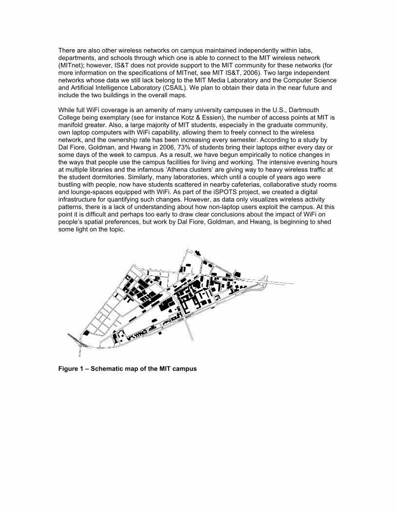
There are also other wireless networks on campus maintained independently within labs, departments, and schools through which one is able to connect to the MIT wireless network (MITnet); however, IS&T does not provide support to the MIT community for these networks (for more information on the specifications of MITnet, see MIT IS&T, 2006). Two large independent networks whose data we still lack belong to the MIT Media Laboratory and the Computer Science and Artificial Intelligence Laboratory (CSAIL). We plan to obtain their data in the near future and include the two buildings in the overall maps. While full WiFi coverage is an amenity of many university campuses in the U.S., Dartmouth College being exemplary (see for instance Kotz & Essien), the number of access points at MIT is manifold greater. Also, a large majority of MIT students, especially in the graduate community, own laptop computers with WiFi capability, allowing them to freely connect to the wireless network, and the ownership rate has been increasing every semester. According to a study by Dal Fiore, Goldman, and Hwang in 2006, 73% of students bring their laptops either every day or some days of the week to campus. As a result, we have begun empirically to notice changes in the ways that people use the campus facilities for living and working. The intensive evening hours at multiple libraries and the infamous ‘Athena clusters’ are giving way to heavy wireless traffic at the student dormitories. Similarly, many laboratories, which until a couple of years ago were bustling with people, now have students scattered in nearby cafeterias, collaborative study rooms and lounge-spaces equipped with WiFi. As part of the iSPOTS project, we created a digital infrastructure for quantifying such changes. However, as data only visualizes wireless activity patterns, there is a lack of understanding about how non-laptop users exploit the campus. At this point it is difficult and perhaps too early to draw clear conclusions about the impact of WiFi on people’s spatial preferences, but work by Dal Fiore, Goldman, and Hwang, is beginning to shed some light on the topic.
Figure 1 – Schematic map of the MIT campus
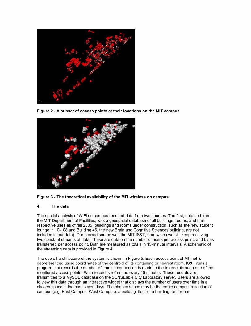
Figure 2 - A subset of access points at their locations on the MIT campus
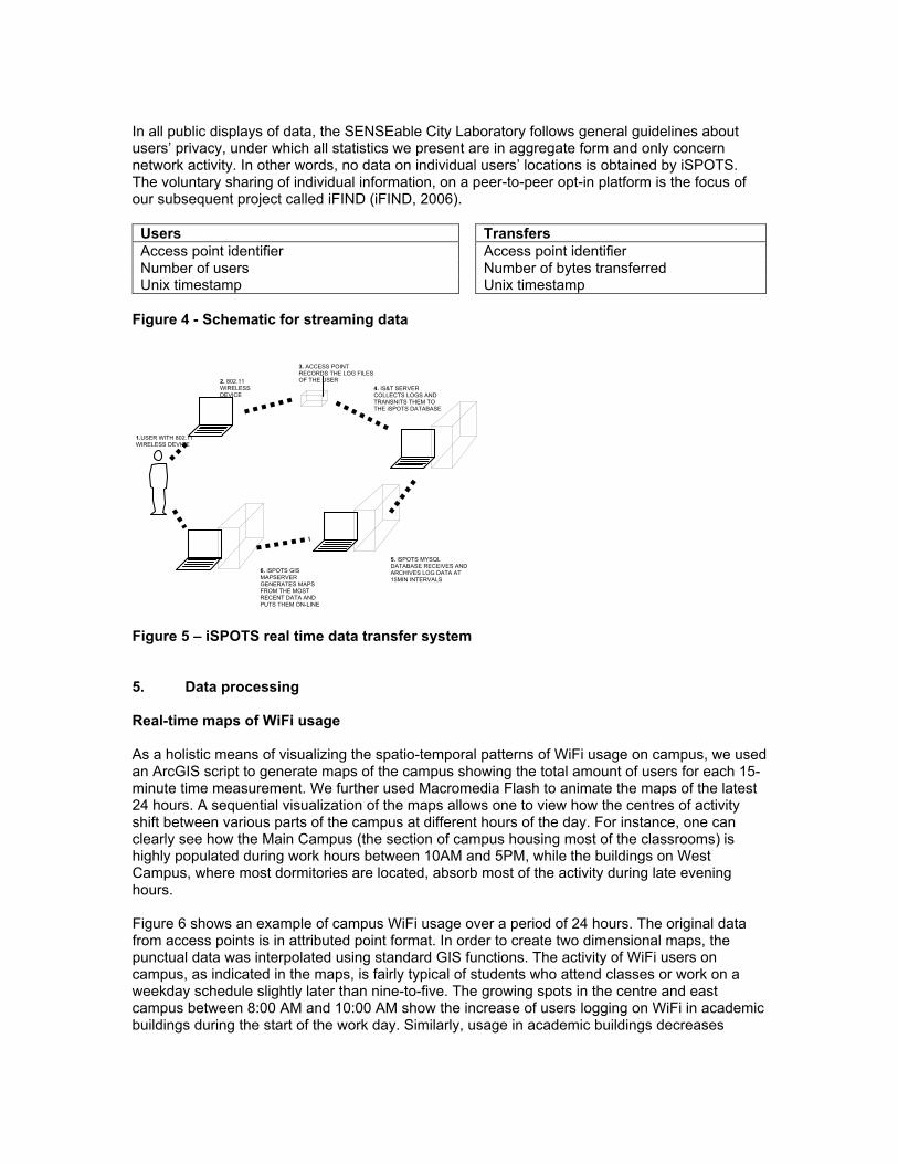
Figure 3 - The theoretical availability of the MIT wireless on campus 4. The data The spatial analysis of WiFi on campus required data from two sources. The first, obtained from the MIT Department of Facilities, was a geospatial database of all buildings, rooms, and their respective uses as of fall 2005 (buildings and rooms under construction, such as the new student lounge in 10-108 and Building 46, the new Brain and Cognitive Sciences building, are not included in our data). Our second source was the MIT IS&T, from which we still keep receiving two constant streams of data. These are data on the number of users per access point, and bytes transferred per access point. Both are measured as totals in 15-minute intervals. A schematic of the streaming data is provided in Figure 4. The overall architecture of the system is shown in Figure 5. Each access point of MITnet is georeferenced using coordinates of the centroid of its containing or nearest room. IS&T runs a program that records the number of times a connection is made to the Internet through one of the monitored access points. Each record is refreshed every 15 minutes. These records are transmitted to a MySQL database on the SENSEable City Laboratory server. Users are allowed to view this data through an interactive widget that displays the number of users over time in a chosen space in the past seven days. The chosen space may be the entire campus, a section of campus (e.g. East Campus, West Campus), a building, floor of a building, or a room.
In all public displays of data, the SENSEable City Laboratory follows general guidelines about users’ privacy, under which all statistics we present are in aggregate form and only concern network activity. In other words, no data on individual users’ locations is obtained by iSPOTS. The voluntary sharing of individual information, on a peer-to-peer opt-in platform is the focus of our subsequent project called iFIND (iFIND, 2006).
Users Access point identifier Number of users Unix timestamp
Transfers Access point identifier Number of bytes transferred Unix timestamp
Figure 4 - Schematic for streaming data
Figure 5 – iSPOTS real time data transfer system 5. Data processing Real-time maps of WiFi usage As a holistic means of visualizing the spatio-temporal patterns of WiFi usage on campus, we used an ArcGIS script to generate maps of the campus showing the total amount of users for each 15-minute time measurement. We further used Macromedia Flash to animate the maps of the latest 24 hours. A sequential visualization of the maps allows one to view how the centres of activity shift between various parts of the campus at different hours of the day. For instance, one can clearly see how the Main Campus (the section of campus housing most of the classrooms) is highly populated during work hours between 10AM and 5PM, while the buildings on West Campus, where most dormitories are located, absorb most of the activity during late evening hours. Figure 6 shows an example of campus WiFi usage over a period of 24 hours. The original data from access points is in attributed point format. In order to create two dimensional maps, the punctual data was interpolated using standard GIS functions. The activity of WiFi users on campus, as indicated in the maps, is fairly typical of students who attend classes or work on a weekday schedule slightly later than nine-to-five. The growing spots in the centre and east campus between 8:00 AM and 10:00 AM show the increase of users logging on WiFi in academic buildings during the start of the work day. Similarly, usage in academic buildings decreases
1.USER WITH 802.11 WIRELESS DEVICE
2. 802.11 WIRELESS DEVICE USING”MIT” WLAN
3. ACCESS POINT RECORDS THE LOG FILES OF THE USER
4. IS&T SERVER COLLECTS LOGS AND TRANSNITS THEM TO THE iSPOTS DATABASE
5. iSPOTS MYSQL DATABASE RECEIVES AND ARCHIVES LOG DATA AT 15MIN INTERVALS
6. iSPOTS GIS MAPSERVER GENERATES MAPS FROM THE MOST RECENT DATA AND PUTS THEM ON-LINE
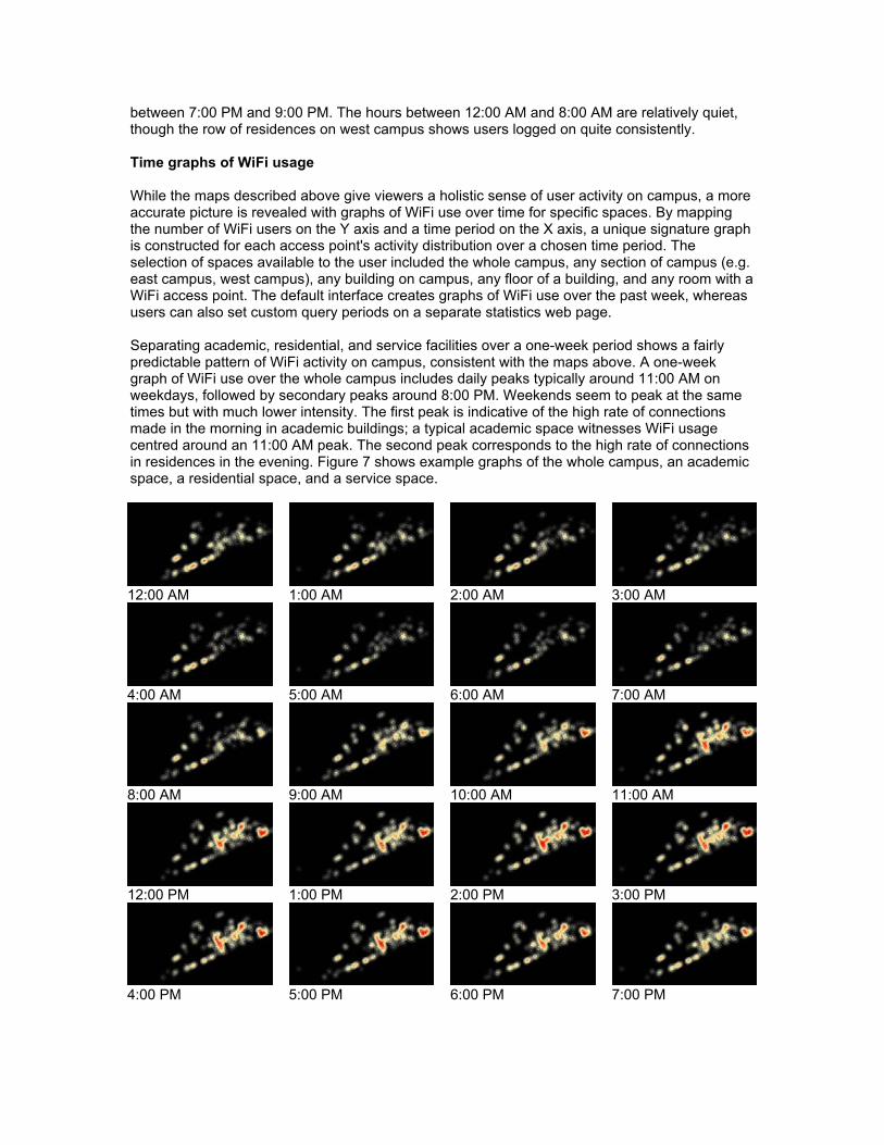
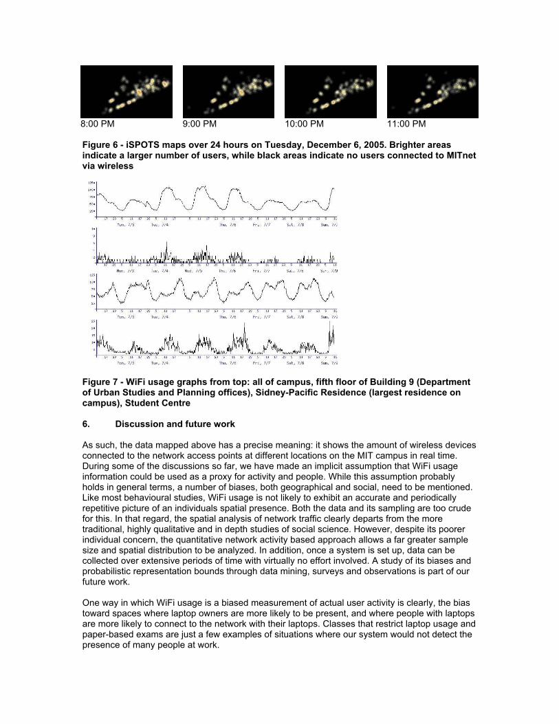
between 7:00 PM and 9:00 PM. The hours between 12:00 AM and 8:00 AM are relatively quiet, though the row of residences on west campus shows users logged on quite consistently. Time graphs of WiFi usage While the maps described above give viewers a holistic sense of user activity on campus, a more accurate picture is revealed with graphs of WiFi use over time for specific spaces. By mapping the number of WiFi users on the Y axis and a time period on the X axis, a unique signature graph is constructed for each access point's activity distribution over a chosen time period. The selection of spaces available to the user included the whole campus, any section of campus (e.g. east campus, west campus), any building on campus, any floor of a building, and any room with a WiFi access point. The default interface creates graphs of WiFi use over the past week, whereas users can also set custom query periods on a separate statistics web page. Separating academic, residential, and service facilities over a one-week period shows a fairly predictable pattern of WiFi activity on campus, consistent with the maps above. A one-week graph of WiFi use over the whole campus includes daily peaks typically around 11:00 AM on weekdays, followed by secondary peaks around 8:00 PM. Weekends seem to peak at the same times but with much lower intensity. The first peak is indicative of the high rate of connections made in the morning in academic buildings; a typical academic space witnesses WiFi usage centred around an 11:00 AM peak. The second peak corresponds to the high rate of connections in residences in the evening. Figure 7 shows example graphs of the whole campus, an academic space, a residential space, and a service space.
12:00 AM 1:00 AM 2:00 AM 3:00 AM
4:00 AM 5:00 AM 6:00 AM 7:00 AM
8:00 AM 9:00 AM 10:00 AM 11:00 AM
12:00 PM 1:00 PM 2:00 PM 3:00 PM
4:00 PM 5:00 PM 6:00 PM 7:00 PM
8:00 PM 9:00 PM 10:00 PM 11:00 PM Figure 6 - iSPOTS maps over 24 hours on Tuesday, December 6, 2005. Brighter areas indicate a larger number of users, while black areas indicate no users connected to MITnet via wireless
Figure 7 - WiFi usage graphs from top: all of campus, fifth floor of Building 9 (Department of Urban Studies and Planning offices), Sidney-Pacific Residence (largest residence on campus), Student Centre 6. Discussion and future work As such, the data mapped above has a precise meaning: it shows the amount of wireless devices connected to the network access points at different locations on the MIT campus in real time. During some of the discussions so far, we have made an implicit assumption that WiFi usage information could be used as a proxy for activity and people. While this assumption probably holds in general terms, a number of biases, both geographical and social, need to be mentioned. Like most behavioural studies, WiFi usage is not likely to exhibit an accurate and periodically repetitive picture of an individuals spatial presence. Both the data and its sampling are too crude for this. In that regard, the spatial analysis of network traffic clearly departs from the more traditional, highly qualitative and in depth studies of social science. However, despite its poorer individual concern, the quantitative network activity based approach allows a far greater sample size and spatial distribution to be analyzed. In addition, once a system is set up, data can be collected over extensive periods of time with virtually no effort involved. A study of its biases and probabilistic representation bounds through data mining, surveys and observations is part of our future work. One way in which WiFi usage is a biased measurement of actual user activity is clearly, the bias toward spaces where laptop owners are more likely to be present, and where people with laptops are more likely to connect to the network with their laptops. Classes that restrict laptop usage and paper-based exams are just a few examples of situations where our system would not detect the presence of many people at work.
A second source of bias in the interpretation of the data could be the uneven distribution of laptop ownership: while we are quickly moving towards uniform and saturated ownership, graduate students are currently the segment in the MIT community with the highest proportion of laptop owners. In addition, laptop usage is likely to vary among different departments, employment types as well as temporal habits. In general, as of spring 2006, IS&T registered an average of 5,373 unique WiFi users per day, about quarter of approximately 20,000 MITnet users (MIT, 2006). Finally, we realize that laptops are often left connected to wireless Internet when not in use. If this information is superimposed onto the data transfer at each access point, it is possible to distinguish between the amount of active and inactive users. However, some biases could still occur (e.g., people may download files when their computer is idle). While the accuracy issues highlighted above are being defined, the iSPOTS data can already be used in a qualitative way for campus planning purposes. The data reveals the dominant trends in people's mobility and may be used to substantiate with numerical evidence observations that have been simply anecdotal so far. The Planning Committee of MIT, for instance, could take notice of the emerging spatial changes of live/work environments, and redirect their efforts to support the new trends. A good example is the recently completed ‘Steam Café’ on the fourth floor of the architecture building, which underwent a complete remodelling during January 2005 (Steam Café, 2006). The design and execution was left in the hands of students of architecture, who not only used the opportunity to redesign the cafe, but also re-conceptualize the cafe’s image and menu. Before its conversion, the area that is now Steam Café was used by few and only for a very limited time each day – the lunch break. Now, thanks to the overlapping of different activities, the presence of WiFi, and a new concept in design (not to mention better food), it is active ‘round the clock’. Sales have increased three-fold and the Space Committee is beginning to recognize that a more efficient environment could emerge by extending similar concepts to the whole campus. It is also possible to imagine future scenarios, based on the iSPOTS system: Scenario 1. When the MIT Space Committee engages in negotiations with a new evening snack cafeteria to open on campus, they can use the iSPOTS archive to aid their decision in site selection. With a few simple queries, they may find, for example, residence areas where WiFi usage shows large numbers of users during afternoon and evening hours. They might even find that the best opening hours for the cafeteria are not standard 9-to-5 working hours, but rather, when most wireless usage occurs in the vicinity. Scenario 2. A more sobering yet still realistic application is emergency situation. For example, if a security alert, such as a fire alarm or a toxic gas leak occurs in a large building, then security officers could easily check the current status of WiFi usage in that building and make an intelligent guess about how many people might be inside the building. Even though not everyone uses WiFi and as most people only use it for a limited period during the day, corrections could be applied to the data by using statistics that have been observed over longer periods of time. For instance, with an accurate estimate of the percentage of laptop users in a building and among those, the percentage of them that are WiFi connected, one may calculate the total predicted number of people in the building with fair probability. Scenario 3. Most certainly, the real-time on-line database could become a useful and fun information tool for MIT students on a daily basis. For instance, an architecture student, who is working at home, might be wondering if it would be better to work in his/her studio at school, because other friends might be working there too. In this case he/she could go on-line to the iSPOTS map and run a query for the given studio space and see how many people were currently using wireless internet in that space. If the network turns out to be busy, then he/she might want to move and join the others.
There are many other examples of possible uses for the real-time analysis capacities of the iSPOTS project. The availability of real time views of the campus activity can allow the creation of feedback mechanisms, which prompt reactions similar to those observed in real time control systems (for a general introduction to control systems see Shinner, 1998; for an exploratory discussion of what that might mean in the urban context see Mitchell, 2005, and Calabrese, Kloeckl and Ratti, 2007). A similar implementation might in the near future apply to neighbourhoods or even cities at large, where urban processes could be observed in real-time from the broadest flux in the city to the highly specific queries about single buildings. As urban GIS data are expanding world-wide, greater opportunities are created for urban analysis. In addition, GIS data exchange over the Internet also enables information to be shared from multiple other databases in the city or around the world. In short, the ever-increasing amount of urban data that are recorded every day with painstaking precision can find many uses in an on-line environment, which enables either all or selected users to find vast amounts of accurate real-time information about the city around them. The implications of a real-time mapping exercise include not only a new tool for mapping, but also a changing perception of the campus or city as a whole (Ratti and Berry, 2007). We acknowledge that the goals and representations of such mapping are clearly different from traditional urban mapping, and we do not want to contest the value of such maps. Rather, we hope to enrich the palette of urban mapping by introducing a new tool, which can help us visualize the city as a set of processes and broaden our perspective on the complex interrelationships of its elements. If the image of a map changes from static to dynamic and acquires different layers of real-time information, then the map is no longer a fixed reference, representing the durable objects and spaces of the city. A real-time map becomes as lively as the urban environment it represents, and is literally shaped by the users of the environment. In a real-time map, not only urban elements, but also processes are spatially represented. A public on-line distribution of the map allows large numbers of people to monitor the urban flux simultaneously, thus raising the public awareness of the dynamism of the contemporary city through simple cartographic evidence. Finally, visualizing aggregate people's movement trough secondary sources such as WiFi, is of course not the same as understanding the movements and the causes behind them. Spatial analysis of wireless network traffic merely creates an opportunity for urban scholars to perceive the interactions between people and the built environment. As two dimensional mappings of thousands of users in actual spaces, the iSPOTS maps collapse a great deal of complex information into single images. We acknowledge the challenges and dangers of omitting valuable traditional knowledge from such representations and focusing perhaps too much on a single chosen variable: the spatial presence of people, which can blind one from a more qualitative understanding of spatial occupancy. The untangling of the complex causal and correlational relationships between physical spaces and their human use is still waiting for its thorough scholarly study, and we look forward to participating in such future work. 7. Conclusions and future work This paper reviews ongoing research on the iSPOTS project at the MIT campus in Cambridge, MA. The aim of the project is to analyze usage of the wireless Internet network in order to describe occupancy patterns and movements of its users. Interim results seem to suggest that this type of analysis is very powerful and could have many applications – whose relevance could extend to entire cities in future years when they become wireless. iSPOTS takes real-time data about usage on WiFi access points as a measure of how people use space on the MIT campus. We created interfaces to retrieve data in the form of colour-coded maps and time graphs, for users who may be interested in analyzing the use of specific spaces. We found that data on individual user locations can be useful to users themselves through a peer-to-peer social networking and location-sharing applet. In the next few years, as wireless computing continues to expand into wider urban areas and programs that depend on ubiquitous

wireless computing, our system may inform planners and administrators of these environments and programs of likely user responses to spatial conditions. Regarding the MIT campus, we hope that iSPOTS data will soon shed light on a number of changes that are happening due to pervasive wireless accessibility. In particular, we would like to validate or disprove a number of hypotheses. For instance: are we really witnessing a switch towards increasing mobility in individual working patterns (see for instance Ratti, Mitchell, Frenchman, 2007)? Is it true that traditional classifications of space do not hold anymore, as people are changing their working patterns due to the introduction of wireless communication? And finally, one of the most important questions for architects and planners: if you can be at work anywhere, where would you like to be? What are the architectural qualities of spaces that people vote for with their feet? 8. Acknowledgements First, we would like to thank the other members of the iSPOTS team, without whom this project would have not been possible: Daniel Gutierrez, David Lee, Xiongjiu Liao and Jia Lou. Our acknowledgments also go to Jerry Grochow, Vijay Kumar, Teresa Regan, Mark Silis and Dennis Baron, who granted us access to the data on the usage of the MIT wireless Infrastructure and helped us with interpreting them. Vijay Kumar and the MIT Direction of Academic Computing also provided generous seed funds for launching the iSPOTS project. We are also indebted to people at the Massachusetts Institute of Technology for their feedback and for providing an extremely stimulating research environment. In particular, we would like to thank Dennis Frenchman, William Mitchell and Lawrence Vale. Janet Owers provided editorial guidance. Of course, any shortcomings are our sole responsibility. 9. References Balazinska,M.&Castro,P.(2003).Characterizingmobilityandnetworkusageinacorporatewirelesslocal‐areanetwork.in
MobySys‘03.
Calabrese,F.,Kloeckl,K.&Ratti.,C.(2007).WikiCity:Howcanacityperformasarealtimecontrolsystem?.papersubmittedtoCUPUM2007.
Chinchilla,F.,Lindsey,M.&Papadopouli,M.(2004).Analysisofwirelessinformationlocalityandassociationpatternsinacampus.inIEEEInfocom04.
DalFiore,F.,GoldmanE.,HwangE.(2006).DoesLaptopUsageAffectIndividualMobility?.MITPaper,forthcoming.
Henderson,T.,Kotz,D.&Abyzov,I.(2004).Thechangingusageofamaturecampus‐widewirelessnetwork,inMobiCom’04:Proceedingsofthe10thannualinternationalconferenceonMobilecomputingandnetworking,ACMPress,NewYork,NY,USA,pp.187–201.
iFIND(2006).http://ifind.mit.edu,accessedon12December2006.
JWire(2006).http://www.jiwire.com/search‐hotspot‐locations.htm,accessedon12December2006.
Kotz,D.&Essien,K.(2002).Analysisofacampus‐widewirelessnetwork.TechnicalReportTR2002‐432,Dept.ofComputerScience,DartmouthCollege.
Kotz,D.&Essien,K.(2005).Analysisofacampus‐widewirelessnetwork.WirelessNetworks11,115–133.
MIT(2006).http://web.mit.edu/measures,accessedon12December2006.
MITIS&T(2006).http://web.mit.edu/ist,accessedon12December2006.
Mitchell,W.(2005).TheRealTimeCityDomus,October2005,885pp.94‐99.
Ratti,C.,Berry,D.(2007).SenseoftheCity:WirelessandtheEmergenceofReal‐TimeUrbanSystems.inChateletV.(editor),InteractiveCities,EditionsXYZ,Paris.
Ratti,C.,Mitchell,W.,Frenchman,D.,(2007).Frommixed‐usedevelopmentstomulti‐layeredspaces:howpervasivewirelessaccessibilitymightchangearchitectureandurbandesign.papersubmittedtoCUPUM2007.
Schwab,D.&Bunt,R.(2004).Characterizingtheuseofacampuswirelessnetwork.inIEEEInfocom04.

Sevtsuk,A.&Ratti,C.(2005).iSPOTS:HowwirelesstechnologyischanginglifeontheMITcampus.Technicalreport,SENSEableCityLaboratory,MIT,Cambridge,MA.
Shinners,S.M.(1998),ModernControlSystemTheoryandDesign.Wiley‐IEEE.
SteamCafé,(2006).http://steamcafe.mit.edu,accessedon12December2006.
Tang,D.&Baker,M.(2002).Analysisofametropolitan‐areawirelessnetwork.WirelessNetworks8(2–3),107–120.
Preserving Faceted Identity in Mobile Devices Privacy preservation for social media (Work-in-progress)
N. Narasimhan, J. Wickramasuriya, J. Engelsma and V. Vasudevan {nitya, jehan, jonathan.engelsma,venu.vasudevan}@motorola.com
The Mobile Device Perspective Mobile devices are rapidly making the transition from being simple communication entities to richer converged devices that provide support for computation, content consumption and contextually-relevant information retrieval. In that respect, we are increasingly seeing mobile phones used as “information appliances” – entities that can both generate such content and consume it. Their rich capabilities – including both short-range and long-range networking – also facilitate the sharing of such information with both proximate and remote users. Their pedigree as a communication device also serves to make them ideal conduits for social interaction – where information sharing is often either a precursor or a follow-up to interactive conversation. Finally, their always-on, ubiquitous presence on the user makes them a richer source of personalization and context information than any other single consumer device. From an industry perspective, this makes the mobile device an ideal target for content and information service providers as well as to advertisers. However, from the user’s perspective, the same properties that make the device valuable as a tool for social networking also pose a threat to personal privacy. By definition, social media applications cannot thrive without an actively participant community – consequently, there is a real need for novel solutions that enable participative experiences while preserving privacy, thereby minimizing the perceived penalty in information disclosure within these communities. Thus, to incentivize users to exploit their mobile devices for such participative media experiences, we need to (a) understand what privacy means in this context, (b) identify the user’s needs for privacy preservation, and (c) provide intuitive but relatively effortless ways for users to ‘tune’ their participation levels to reflect their desired level of privacy for given contexts. At the same time, we also need to recognize that any solution to this problem must deal with the inherent limitations of the mobile device (e.g., input constraints that make manual data entry difficult) as well as the likelihood that the user may be otherwise engaged (e.g., on a phone call), making constant interruptions from a privacy-preserving service intolerable. Any solution that requires the user to remain constantly in-the-loop on privacy-enforcement decisions will likely result either in users declining to use the related application (citing poor user experience1) or in users establishing universal defaults that can either compromise the user’s privacy (by being too lenient) or reduce the effective utility received (by being too strict).
1 Industry reports indicate an almost exponential decline in usage of features on the phone with every additional “click” required to access them.
Privacy Preservation for Social Media While we deliberately chose social media as the domain of interest, we believe some of the same observations and issues relate equally well to locative media and ubiquitous computing. By definition, locative media typically involves rich user experiences tied to a particular location. In turn, location media can trigger (or be triggered by) social media experiences where the information awareness is transformed into (or is a result of) communication with other users. Non-locative social media experiences also exist – for example, presence applications that help users remain in touch with (or aware of) remote friends or family. Such applications have inherent utility to the user (incentive for participation) but also can conjure up visions of privacy violation (‘big brother’ fears for location tracking, and ‘spam overload’ caused by social sharing). In the context of social media, information disclosure typically revolves around activity (my presence) or data (my music, my videos, my photos, my notes, my business cards). By definition, privacy preservation involves enabling user control over any information disclosure. Users want to have a say not only in “what” information they share, but also in “when” they share it and “with whom”. While the {what, when, with whom} define access control parameters for information sharing, the user’s configuration of these parameters is often influenced by three factors: • Knowing why that information is being shared. In general, we think there are two
reasons why people share information – reputation and utility. Sharing my music tastes with others helps me gain a reputation in my social circle as someone with good taste, or with access to cutting edge music releases. On the other hand, sharing my tastes with a music community (e.g. Last.FM) enables me to leverage music recommender systems – thereby reducing my effort in discovering new or relevant music. Research analysis shows that users look at the context of a request as a key criteria in making the decision to share.
• Knowing how that information will be used. One of the dominant fears behind sharing of information – particularly personal information (contact data) as opposed to public information (music data) – is that we have essentially lost control over the data once it is shared. Giving this information to a third party puts us in a position of having to trust implicitly that they will use the information in a manner that meets with our approval. Privacy researchers agree that clearly-defined privacy policies go a long way towards establishing such trust for organizational recipients, particularly since the enforcement of them (by legal means) provides users a measure of control. But how does a human recipient establish his privacy policy? And how do I, as the user, enforce the policy or prevent a violation of this trust?
• Knowing the cost of sharing that information. This aspect is generally a derivative of the why and how, but is interesting in that it focuses on the characteristics of the data that is being shared, rather than on the identity of the recipient. We observe that there are typically two kinds of data – personal and public – where personal is generated by the user (e.g., photographs) or so closely associated with him/her as to provide a clear means of identification (e.g., contact info, credit card info). Public data is generally something that is known to many people (e.g., music data, restaurant contact info) and can thus be assumed to be widely available. However, sharing of each kind of data has a cost associated with it. We identify three types of cost:
o Reputation. This is interesting in that the cost is estimated in terms of damage to one’s identity or character as seen by others, but is best evaluated only by the user. Reputation costs are incurred when the user is the originator of the shared data such that his or her identity is now associated closely with that information. The persistence of online memory also ensures that shared data can incur delayed reputation cost, where the impact is not immediately visible, but is felt at a later date when the information resurfaces in a different context.
o Annoyance. Increased knowledge about a user is a boon to the marketing and advertising companies, but can be a curse for the user, targeting them for promotions and spam from unscrupulous marketers. Any disclosure of information that also exposes a conduit for communicating back with the user (e.g., phone, email or mailing address) creates more such opportunities. Thus, annoyance costs are incurred when the user becomes the recipient of shared data. On a mobile device, the resource constraints (including battery drain and limited storage) serve only to exacerbate the impact of these costs.
o Monetary. Perhaps the most tangible or quantifiable form of cost in that it is easy to evaluate. Monetary costs can be incurred in two ways. First, by misuse of shared data – for example, sharing personal credit card information or contact information can expose the user to identity theft and its associated monetary penalties. Second, as an indirect result of the act of sharing or receiving information on mobile devices. For instance, sharing data over the wide-area network can incur data or messaging charges, as well as potential charges for purchasing the application or service to enable this behavior.
While we see monetary cost as being important – particular in mobile devices where annoyance (e.g., spam) and reputation (e.g., loss of influence) can translate into added monetary costs (e.g., data charges or loss of advertising revenue) – we focus initially on addressing annoyance and reputation costs for mobile social sharing.
Ambient, Adaptive Privacy Sliders In particular, we believe that these costs are impacted by the notion of users having faceted identities2 where different facets are invoked when interacting with different groups of people (e.g., family facet vs. work facet). Reputation is closely associated with the facet that the user wishes to present to his existing environment. Thus, a reputation cost occurs when a user inadvertently shares information pertinent to one facet (e.g., pictures at the club with friends) with members normally associated with a different facet (e.g., work colleagues). For instance, social clique behavior in high schools illustrates the irreparable harm that occurs when members inadvertently expose a facet of their identity that reflects poorly on that of the clique, or that shows their empathy for a rival or lesser clique. To minimize these costs, users need mechanisms that can evaluate the context of their existing environment, identify the most relevant facet(s) to reveal in that context, and apply the access controls specified for that facet, by the user, when sharing and receiving information with others. Thus, a privacy preservation solution for mobile social media must provide 2 D. Boyd, “Faceted Id/entity: Managing representation in a digital world”, August 2002, MIT Masters Thesis, http://smg.media.mit.edu/people/danah/thesis/
• An access control mechanism that allows users to define their {what, when, with whom}criteria for information sharing
• an information mechanism that allows users to understand the {why, how, how much} criteria when configuring the controls
• a tuning mechanism that monitors information dynamically and responds by adapting the controls so as to minimize the effective “cost” to the user.
Furthermore, these mechanisms must be relatively translucent to the user. In other words, they should be transparent for the most part (requiring minimal user engagement or intervention), but expose critical decisions to the user at the appropriate juncture, and in a manner that allows intuitive responses without being overtly invasive. We are currently exploring some ideas in this space, using our existing prototype platform (for social music experiences) as a test bed. In particular, we believe that an effective solution could involve four components:
• Facet manager. Allows users to define different facets in terms of the contextual cues that determine its active status. For example, users may define a work facet as being active when location=office, or proximity=colleague.
• Data manager. Allows users to establish access control criteria for information sharing, on a per data-store basis. A data store could be a physical (database) or logical (all music with genre=rock) collection of data items. The data manager also associates each data store with the relevant facet based on user input.
• Privacy dial. A simple tunable indicator that provides the user with a sense of the degree of privacy provided by his current device access control and facet settings. The dial extremities can indicate total trust (allow all) or total paranoia (deny all) settings across all data stores, while intermediate settings can cause only select subsets of data stores to be affected based on their current access levels.
• Ambient feedback. A visualization of the cost analysis performed on the device given its current context vs. current settings. For instance, a simple color indicator (red=vulnerable, orange=caution, green=safe) can provide the user with a quick sense of the efficacy of his current privacy settings, thereby prompting him or her to tune the current privacy dial settings till the ambient feedback registers a suitable state. Note that the “safe” state may not always be the most suitable state since it may increase privacy at the cost of decreased utility (e.g., no sharing).
In conclusion, we believe that emerging interest in social media is driving the need for privacy preservation mechanisms for mobile devices. In particular, research in this area needs to take into account the resource constraints of the device, the faceted identity of the users, and changing requirements (context) of the environment – in crafting suitable solutions that are easy to use and are born adaptive to different user or environmental requirements. We are currently exploring directions that leverage the existence of a rich context framework and an interstitial ambient interface on the mobile device as a first step to developing a usable privacy preservation solution for mobile social media.
come_IN: Fostering communities in multicultural neighbourhoods
Volker Wulf & Michael Veith & Kai SchubertUniversity of Siegen, Germany
{volker.wulf, michael.veith, kai.schubert}@unisiegen.de
IntroductionIn this paper we will focus on one underserved community in Germany – a GermanTurkish migrant community in the city of Bonn. The first group of Turkish people came to Germany as immigrant workers in the 1960’s and early 1970’s, planning only to stay for a couple of years. Still nowadays, there are significant inequalities between the Turkish communities and the German host society. The degree of social as well as political participation appears to be rather low. The socioeconomical situation of Turkish inhabitants compared to mainstream Germans, is worse, which (as it applies to other socioeconomically weak communities) leads also to the vicious circle of a low level in education for many Turkish Germans.
The field of application in which we attempt to implement our methodological approach is a intercultural computer club. Located in the city of Bonn, the club runs since more than three years in cooperation with a local primary school. It allows pupils of the school to come once a week to work on joint projects supported by ICT. Each child has to be accompanied by at least one parent. Turkish inhabitants of the neighbourhood work together with Germans in order to collect, construct, and demonstrate commonly shared, relevant realworld and computer artefacts.
In short first we describe our approach related to an underserved community, followed by an description of the experiences of the computer club.
A Migrantsoriented Approach to ICTGermany and other modern western societies are facing migration from countries with distinctly different sociocultural backgrounds. Democratically constituted states should encourage social participation of all of their inhabitants, since it is a necessary condition for a sufficient level of integration. The lack of social, as well as cultural integration seems to lead to unequal opportunities and lower levels of education which are specifically problematic for migrants of the second and third generation.
Looking at modern western societies, we see integration processes of migrants often running into problematical states or even failing. Although existing for more than forty years in Germany, the Turkish community is still poorly integrated. When starting with primary school, immigrant children of the third generation still show, for instance, a significant deficiency in the German language compared to other pupils of the same age. Moreover, the social gap between the Turkish immigrant community and the host society seems to be widening recently due to an unequal access to computer infrastructures. This digital divide is an issue referring to the socioeconomic gap between communities that have access to computers and the Internet, to those who do not have.
In Germany, only a few studies exist on how migration appropriate computers and digital media. There is a significant similarity between children from Turkish and German families regarding their wishes and preferences toward the use of digital media. In order to avoid the digital divide in the Information Society, special support for migrants seems to be necessary. There are some initiatives who try to deal with these problems in the German context. The foundation “Digitale Chancen” (“digital chances”) believes that digital media offer opportunities for integration. The empowerment through the appropriation of new media is an important step for migrants. It helps them to express
their needs and to represent themselves to gain more (political) participation.
The effects of digital media on the integration of immigrants are not always considered to be positive. Critics say that global access to media content will increase the cultural segregation. For instance, one may argue that the availability of Turkish satellite TV plays a role in the deterioration of the third generation’s lack of German language skills.
When developing our approach to intercultural computer club houses, we were influenced by the work of the computer clubhouses (CCH). The concept of a computer clubhouse aims at teenagers in the US coming from lower social classes and educational backgrounds (inner cities). The pedagogical concept is derived from the constructivist learning paradigm. Social ties are established during the process of constructionist learning. As a result, social capital is a part of the underlying concept of the CCH. In the first phase of our work, we subordinated the development of innovative tools for learning to the needs of community building.
When developing our action research approach for the intercultural computer club, we were inspired by the theories on Communities of Practice (CoP) as well. In our case, CoPs are an interesting theoretical concept since they relate to the experience of shared practice to the process of identity building and knowledge acquisition. Learning in a CoP is defined by the relationship of older generations and newcomers which are inside the community. As newcomers interact, work, and communicate with the older generations their experiences increase. CoPs are characterized by common conventions, language, tool usage, values, and standards. Identity is mainly determined by negotiated experience of one's self in terms of participation in a community and the learning process concerning one's membership in a CoP. Following these theoretical considerations, our approach intends to establish a CoP bridging between segregated ethnic communities. We assumed that the establishment of a shared practice among members of ethnic communities would have an impact on the actors’ individual and, in a longer term perspective, on the ethnic communities’ social identity. Since we do not believe in social determinism, such interventions will increase the likelihood of a CoP’s emergence rather than forcing it into existence.
The Computer Club “come_IN”We evaluated our research approach in a project which takes place in the so called “Bonner Altstadt”, a multicultural neighbourhood within the city of Bonn. The Bonner Altstadt has a population of about 8,700 inhabitants. The social and cultural structure of this district can be characterized as a colourful mixture of different communities. Statistical data characterizes this situation today: The quarter has a high rate of immigrants (~28% of the population, in comparison to 22% in Bonn as total) and a low education rate. However, the German community consists to a considerable part out of academics, partly former students who stayed in the quarter after their graduation.
In the German context, primary schools are important places where collocated but segregated communities meet. Since most kids attend the public primary school in their local district, schools became one of the very few places where people unavoidably come into contact with different cultures. Therefore, schools in multicultural neighbourhoods face considerable challenges in dealing with a differentiated population of pupils.
The computer club “come_IN” is conducted in cooperation with Marienschule, an primary school in the Altstadt district. The focus lies on open and work oriented lessons, e.g. in small groups, workshops, projects, and so on. Each class room is equipped with 23 computers which can be used as resources in daily work. Pupils are taught in classes with mixed agegroups. Beyond the neighbourhood, the school has gained reputation for its innovative pedagogies and didactic practice.
The club has 13 personal computers, one multi media computer, several digital video and photo cameras, a video projector, and several other digital devices, which are used. There is a big, round table in the middle of the club room, which is used for discussions and other communicative events. In the following, we will present the core concepts which were developed in an attempt to establish a multicultural CoP.
We decided to establish a shared practice across the ethnic communities by encouraging participants to jointly work on computersupported projects. We assumed that dealing with computers and digital media would be attractive for many participants within the different ethnic communities. However, we believed that by just offering an infrastructure for a shared practice would not be enough to start the process.
To impact identities in the different ethnic communities, we would not only need to attract the students, but also the parents. Since the success of schooling is highly related to the social context of the children, schools and parents need to work together. Thus, we introduced the rule that children may only come to the club if accompanied by at least one parent. By this rule, we used the attraction computers have for children to get parents involved in the process. In addition, it is hard for primary school kids to manage complex projects by themselves. Conceptual support from their parents was needed to realize the envisioned project’s outcomes. While establishing a projectrelated practice, we assumed that foreign and German parents would have more exposure and therefore communicate with each other.
One of the first projects deals with a multimedia documentation of family histories. Right now, already three generations of Turkish immigrants live in the neighbourhood. However, their cultural histories are only poorly, if at all, documented. These family histories should be presented together with German ones from the same neighbourhood. Such a shared history may support the growth of a joint identity across the different communities.
Another project deals with sports, more particularly, soccer. Children, parents and teachers decided together about this project. In the beginning, children and their parents prepared a number of matches between different teams of pupils. During these matches, various ICT was used to record the project. Parents and children were improving their abilities in the use of this ICT while creating stories, photo presentations and a film about the soccer matches. In addition, after the first matches, several Turkish parents arranged for another match against a local Turkish soccer club. This will give the computer club more exposure to their community, creating a new level of impact with an important potential for the future.
1
Voices From Beyond: “Urban Archaeology: Sampling the Park”, "The Haunting" and Mobile, Locative Experience Design Dr. Barbara Crow, York University/MML Prof. Michael Longford, Concordia University/MML Dr. Kim Sawchuk, Concordia University/MML
The Mobile Media Lab (MML) is a Canadian interdisciplinary research team exploring the new environment of wireless communications, mobile technologies and locative media practices. By developing interactive mobile experiences we are able to observe and reflect first-hand on the dynamics inherent in wireless immersive environments. Each of our projects moves us closer to understanding how these technologies may augment, enhance, deplete, or mediate our culturally situated experiences of urban and outdoor spaces. In part, what makes our projects possible is a paradigm shift in computation to what we now refer to as ubiquitous or pervasive computing. Rather than constructing virtual worlds and experiences, we can now embed information into ambient social interactions that are played out in the physical world. Our projects treat physical territory as an active and volatile interface creating networked situations to connect the physical to the virtual in ways that quietly augment everyday experiences rather than replacing them with artificial virtual worlds, such as those that were popularized in the 1980s by William Gibson’s novel Neuromancer. The following research questions have shaped our research and are critical to the works that we have been developing at the Mobile Media Lab: 1) How can an awareness of environmental contexts, social histories and local knowledges lead to an engagement with outdoor spaces?; 2) How might mobile technologies and game play lead to the development of interactive new media genres?; 3) How can narrative, character development, location based play structures, gesture choreography, information architecture combine to structure an awareness of space and place; and 4) What forms of content development for mobile devices are appropriate for outdoor experiences in urban and natural environments? For this workshop we will present two projects, Urban Archaeology: Sampling the Park and The Haunting, that were part of our participation within the Mobile Digital Commons Network (MDCN, 2004-2007). We will use the phrase, voices from beyond, as a trope in our reflection upon the use of mobile media technologies in the context of locative media design that intentionally blurs past and present moments. We will begin our workshop with a brief discussion of Urban Archeology, which was installed at Place Émilie-Gamelin in Spring 2005. It was the first of the MDCN Projects to engage with emergent social behaviours utilizing historical information in a poetic fashion to tell the story of a place. This project explored the social history of a city square in Montreal using sound, image and GPS sensors to examine the ways in which memory can be inscribed in space, drawing on field recordings, oral history, and archival material to form a layered mediascape. We chose Parc Émilie-Gamelin as it is nested in a prominent intersection where mobility of all forms is represented in one of the densest
2
areas of Montreal. While working on the project we began to see the park as emblematic of a number of competing interests, between the city, capital, small businesses, the nearby residents and institutions, and the different populations inhabiting the park itself. This project forms the backdrop for a more detailed discussion of The Haunting, a location based cell phone game with a historical twist currently in development for Parc Mont Royal in Montreal. A location-based mobile experience ghost-capture game, The Haunting utilizes Bluetooth beacons, custom-made open source software, as well as GPS locative technology. Unlike Urban Archaeology, which used the Mobile Bristol Tool Kit, our research team developed hardware (beacons) and open source software (the MEE) to create a working prototype that engages users in a quasi-fictional history of the mountain and immerses them its particular urban ecology. In The Haunting players are invited by VFB Mobility to use a cell phone as the means to explore paranormal disturbances and to communicate with the dead. Media debris, flickering screens, unearthly vibrations, and screaming cellulars inhabit the "Forest of Shadows" surrounding the cross at the summit of the mountain overlooking the park. Interaction scenarios, alternative mapping techniques, spontaneous public performance, and location based play structures rooted in non-linear narrative are explored in mobile experience design. Using GPS and Bluetooth beacons in a networked environment, this project treats the territory of the mountain as a potent and lively interface playing with the potential of mobile technologies to create a relationship to space and place by making us stop for a moment. Users are asked to pay attention to the connections, disjunctures and happenstance moments created when a small screen, held in the hand, is suddenly alight and alive within the overwhelming setting of this park, at night. The atmospheric back story to The Haunting is this: players are contacted by a 'fake' phone company called VFB (Voices from Beyond) who give them instructions on how to play the game. A VFB operator acts as a meta-narrator giving players instructions on the phone itself. The look and feel is "film noir". The goal of the game is to find the ghosts buried on the mountain, capture them in your phone, and then liberate them at the end so that they can rest in peace. There are eight spirits who players encounter during the Haunting game. Four are based on real historical characters with a connection to Montreal. The Allan Sisters, who drowned on the Lusitania as young children, want to find each other. Tomasina, who was the last woman hung in Quebec, was inadvertently decapitated and wants her head and body to be rejoined. Arthur Ellis, the British hangman, acts as an evil presence trying to thwart players from their mission. Harry Houdini, illusionist and escape artist, who received his death blow at McGill University is a "helper" character who warns players about malicious spirits such as Ellis. Others are generic characters built upon various plagues and deaths connected to the history of the city. Players roam the game-space of the mountain searching for the GPS-Bluetooth hotspots where the ghosts are buried. Once they enter the GPS zone, this triggers a sequence of sounds and images (Bluetooth) informing them that they are in the midst of a supernatural presence: the phone may start flashing or vibrating; images appear; and spooky sounds taunt you. Instructions are given on how to capture them on the phone,
3
and to continue the game. Players can keep track of their movements on the mountain, via an interactive map that indicates where the ghosts are, and where they are in relationship to the ghosts. A counter reminds players how many ghosts they have left to capture. The Haunting uses cellular phones, Bluetooth beacons, Global Positioning Satellite (GPS) systems for game play and is run by a software application created with the Mobile Experience Engine (MEE). The Mobile Experience Engine software generates optimized and device-specific applications from a single XML script describing The Haunting game scenarios. For this game, players are issued i-Mate SP3 and Nokia cell phones that have been reprogrammed and which are Bluetooth-enabled. For this project, Bluetooth beacons were created and programmed to detect the presence of the cell phones to activate Haunting content such as pictures, video and/or audio. In conjunction with these beacons, GPS "hotspots" were created to localize and deliver instructions and content for game play. When a cell phone enters these regions, localized game content is delivered and specific interaction scenarios are initiated. For example, GPS location allows players to consult a phone-based map showing their proximity to the ghosts they are trying to capture. In our workshop “Voices from Beyond” we will discuss the technical, theoretical and social issues that have arisen from our project. We are interested in how space and time, including seasonality, pertain to the tensions we have noticed between locative media design and mobile technologies. Theoretically, we draw upon M.M. Bakhtin’s notion of the chronotope, work on the rhetoric of history (White; Lowenthal) and communications theory that deals with the spectral qualities of communications (Durham Peters; Derrida). In so doing we work from the principle that “place is not a given, it is made.” (Digital Ground, Malcolm McCullough, 2005).
In our research, which is technological, cultural and historical, we have considered how the sensory experience of a place can feed a narrative, which is mediated by social behaviors, technology, and physical terrain. We have tried to understand the impacts of humans on these environments, and in turn, how do these environments influence users. We have considered the temporal implications embedded in a space, including seasonal changes, which in the case of Montreal, are extreme. We have negotiated the official policies and regulatory protocols that currently govern the space. Finally, we have considered the people, communities, or other stakeholders involved that we need to consider and consult.
We hope that you will be interested in our projects and in our reflections upon these projects for your workshop.
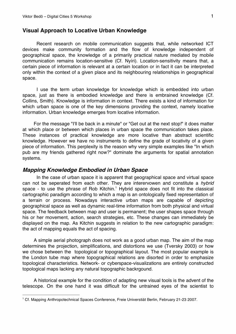
Viktor Bedö – Digital Cities 5 Workshop 1
Visual Approach to Locative Urban Knowledge
Recent research on mobile communication suggests that, while networked ICT
devices make community formation and the flow of knowledge independent of
geographical space, the knowledge of a primarily practical nature mediated by mobile
communication remains location-sensitive (Cf. Nyíri). Location-sensitivity means that, a
certain piece of information is relevant at a certain location or in fact it can be interpreted
only within the context of a given place and its neighbouring relationships in geographical
space.
I use the term urban knowledge for knowledge which is embedded into urban
space, just as there is embodied knowledge and there is embrained knowledge (Cf.
Collins, Smith). Knowledge is information in context. There exists a kind of information for
which urban space is one of the key dimensions providing the context, namely locative
information. Urban knowledge emerges from locative information.
For the message "I'll be back in a minute" or "Get out at the next stop!" it does matter
at which place or between which places in urban space the communication takes place.
These instances of practical knowledge are more locative than abstract scientific
knowledge. However we have no instruments to define the grade of locativity of a given
piece of information. This perplexity is the reason why very simple examples like "In which
pub are my friends gathered right now?" dominate the arguments for spatial annotation
systems.
Mapping Knowledge Embodied in Urban Space
In the case of urban space it is apparent that geographical space and virtual space
can not be seperated from each other. They are interervowen and constitute a hybrid
space - to use the phrase of Rob Kitchin.1 Hybrid space does not fit into the classical
cartographic paradigm according to which a map is an ontologically fixed representation of
a terrain or process. Nowadays interactive urban maps are capable of depicting
geographical space as well as dynamic real-time information from both physical and virtual
space. The feedback between map and user is permanent; the user shapes space through
his or her movement, action, search strategies, etc. These changes can immediately be
displayed on the map. As Kitchin suggests in relation to the new cartographic paradigm:
the act of mapping equals the act of spacing.
A simple aerial photograph does not work as a good urban map. The aim of the map
determines the projection, simplifications, and distortions we use (Tversky 2003) or how
we chose between the topological or topographical layout. The most popular example is
the London tube map where topographical relations are disorted in order to emphasize
topological characteristics. Network- or cyberspace-visualizations are entirely constructed
topological maps lacking any natural topographic backrgound.
A historical example for the condition of adapting new visual tools is the advent of the
telescope. On the one hand it was difficult for the untrained eyes of the scientist to
1 Cf. Mapping Anthropotechnical Spaces Conference, Freie Universtiät Berlin, February 21-23 2007.
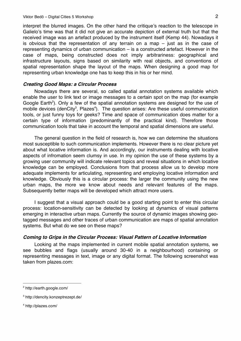
Viktor Bedö – Digital Cities 5 Workshop 2
interpret the blurred images. On the other hand the critique s reaction to the telescope in
Galielo s time was that it did not give an accurate depiction of external truth but that the
received image was an artefact produced by the instrument itself (Kemp 44). Nowadays it
is obvious that the representation of any terrain on a map – just as in the case of
representing dynamics of urban communication – is a constructed artefact. However in the
case of maps, being constructed does not imply arbitrariness: geographical and
infrastructure layouts, signs based on similarity with real objects, and conventions of
spatial representation shape the layout of the maps. When designing a good map for
representing urban knowledge one has to keep this in his or her mind.
Creating Good Maps: a Circular Process
Nowadays there are several, so called spatial annotation systems available which
enable the user to link text or image messages to a certain spot on the map (for example
Google Earth2). Only a few of the spatial annotation systems are designed for the use of
mobile devices (denCity3, Plazes4). The question arises: Are these useful communication
tools, or just funny toys for geeks? Time and space of communication does matter for a
certain type of information (predominantly of the practical kind). Therefore those
communication tools that take in account the temporal and spatial dimensions are useful.
The general question in the field of research is, how we can determine the situations
most susceptible to such communication implements. However there is no clear picture yet
about what locative information is. And accordingly, our instruments dealing with locative
aspects of infromation seem clumsy in use. In my opinion the use of these systems by a
growing user community will indicate relevant topics and reveal situations in which locative
knowledge can be employed. Conclusions from that process allow us to develop more
adequate implements for articulating, representing and employing locative information and
knowledge. Obviously this is a circular process: the larger the community using the new
urban maps, the more we know about needs and relevant features of the maps.
Subsequently better maps will be developed which attract more users.
I suggest that a visual approach could be a good starting point to enter this circular
process: location-sensitivity can be detected by looking at dynamics of visual patterns
emerging in interactive urban maps. Currently the source of dynamic images showing geo-
tagged messages and other traces of urban communication are maps of spatial annotation
systems. But what do we see on these maps?
Coming to Grips in the Circular Process: Visual Pattern of Locative Information
Looking at the maps implemented in current mobile spatial annotation systems, we
see bubbles and flags (usually around 30-40 in a neighbourhood) containing or
representing messages in text, image or any digital format. The following screenshot was
taken from plazes.com:
2 http://earth.google.com/
3 http://dencity.konzeptrezept.de/
4 http://plazes.com/
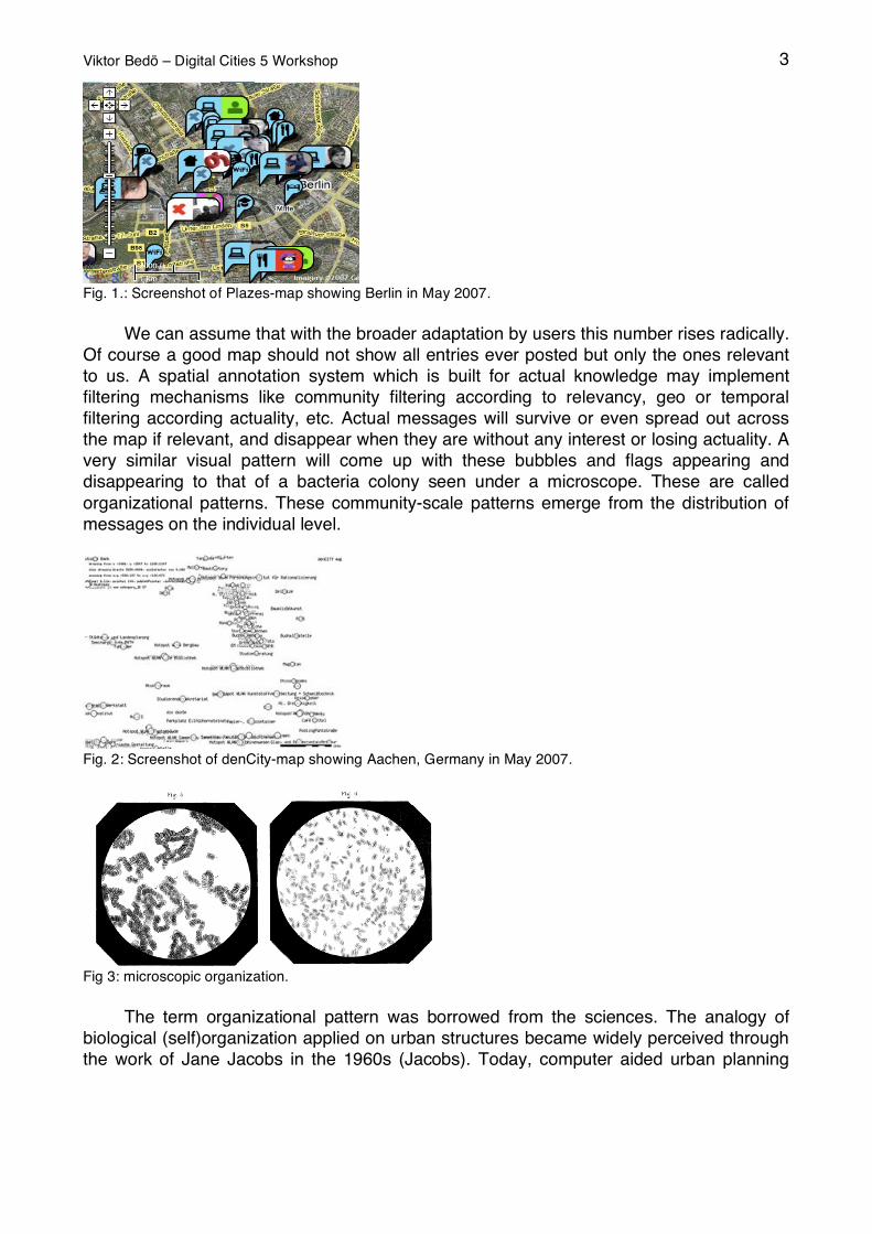
Viktor Bedö – Digital Cities 5 Workshop 3
Fig. 1.: Screenshot of Plazes-map showing Berlin in May 2007.
We can assume that with the broader adaptation by users this number rises radically.
Of course a good map should not show all entries ever posted but only the ones relevant
to us. A spatial annotation system which is built for actual knowledge may implement
filtering mechanisms like community filtering according to relevancy, geo or temporal
filtering according actuality, etc. Actual messages will survive or even spread out across
the map if relevant, and disappear when they are without any interest or losing actuality. A
very similar visual pattern will come up with these bubbles and flags appearing and
disappearing to that of a bacteria colony seen under a microscope. These are called
organizational patterns. These community-scale patterns emerge from the distribution of
messages on the individual level.
Fig. 2: Screenshot of denCity-map showing Aachen, Germany in May 2007.
Fig 3: microscopic organization.
The term organizational pattern was borrowed from the sciences. The analogy of
biological (self)organization applied on urban structures became widely perceived through
the work of Jane Jacobs in the 1960s (Jacobs). Today, computer aided urban planning
Viktor Bedö – Digital Cities 5 Workshop 4
makes use of self-organizing mechanisms found in nature.5 Dawkins mem-concept and
Sperber's epidemological model are the well known examples of this biological analogy
applied to the spreading of thoughts. The latter suggests that culture is a distributional
patterns of individual representation just in the way representations are pattern of neuronal
functions (Pléh).
Patterns appearing on maps of spatial annotation systems are not constructed
according to grammatical rules or syntax. The pattern was created by a community
communicating in urban space. The spatial distribution of messages is generally governed
by the geographical distribution and/or abstract neighbourly relations of individual
messages. Instead of composition made by an individual editor we are confronted with
organisation generated by a community. Because of the spatial character of the
phenomenon we have to rely on specific visual tools when dealing with dynamic
organizational patterns on the community level.
Our question is what do the dynamics of the organizational pattern of spatial
annotation systems maps tell us about the grade of locativity of the messages. Contrasting
the two extremes of the abstract and concrete expressions helps us to understand the
approach. Assigning the entries of an encyclopedia to different points in geographical
space, as in the KLM Layer of Wikipedia for example,6 result in static pattern in space and
time. Locative knowledge draws a more dynamic pattern in time and space compared to
the previous example. The message “Bless you!” for example will presumably produce a
pattern on the map which is as random as the one received for the entry “string theory”. In
contrast, the message "Get out at the next stop!" will probably give patterns that recur
exhibiting a specific order in time and space. We do not know the definite dynamics we
have to look for. All we know is that we have already solved analogous problems by visual
means. Identifying coherent patterns and the dynamics of these patterns on the map is
analogous to the problem of visual discovery in the sciences.
Learning how to use tools in a broad sense, ranging from sticks and probes to
language or scientific formalism, has an unformalizable dimension to it (Polányi). When
medics learn the visual skills to interpret spots on an X-ray or brain researchers learn to
interpret FMRI brain scans they do it by watching an expert. The detection and
identification of patterns “can only be accomplished by someone experienced in looking at
a wide range of such images and who understands the parameters of the equipment.”
(Kemp 320). The researcher is confronted with a new visual pattern when he or she is
using a new instrument, or when discovering the visual traces of a new phenomenon.
Patterns visible on maps of spatial annotation systems are new in both senses: new maps
show new emerging patterns.
Martin Kemp comes to grips with this issue by introducing structural intuition, a
principle by which means artists and scientists extract order from the chaos of visual
phenomena. Structural intuition is shaped by physiological and cognitive structures
(reaching back to pre- or subverbal deep structures) on one hand. On the other hand it is
5 Cf. Computer Aided Architecture Desing at ETH Zürich http://wiki.arch.ethz.ch/twiki/bin/view/Front/ArticleCategoryResearchAll
6 http://en.wikipedia.org/wiki/Wikipedia:WikiProject_Geographical_coordinates
Viktor Bedö – Digital Cities 5 Workshop 5
also shaped by a graviational pull towards visual convention that is the cultural component
in human vision.
Kemp's view is an image-specific variation of Michael Polanyi's theory about tacit
knowledge and the process of scientific discovery. Both of them take into account the
interplay between different organizational levels (individual messages and the pattern of
messages on the community level). Both also discuss the interplay between meaningful
patterns that emerge and our tools of thinking. Consequently, we have to turn our attention
to human vision and to visual discovery in order to develop new tools for practical urban
knowledge emerging on the community level.
References
Collins, Harry M. "Humans, Machines, and the Structure of Knowledge". SEHR
(Constructions of the Mind). vol. 4, no. 2. (1995): 67-83
Jacobs, Jane. The Death and Life of Great American Cities. Jonathan Cape, London,
1962.
Kemp, Martin. Seen / unseen: art, science, and intuition from Leonardo to the Hubble
telescope, Oxford Univ. Press, Oxford, 2006.
Nyíri, Kristóf (ed.). A Sense of Place: The Global and the Local in Mobile Communication.
Passagen Verlag, Vienna, 2005.
Pléh, Csaba. "Thoughts on the Distribution of Thoughts: Memes or Epidemies". Journal of
Cultural and Evolutionary Psychology. vol. 1, no. 1 (April 2003): 21-51.
Smith, Barry. "The Ecological Approach to Information Processing". Nyíri, Kristóf (ed.).
Mobile Learning: Essays on Philosophy, Psychology and Education. Passagen Verlag,
Vienna, 2003.
Tversky, Barbara. “Some Ways Graphics Communicate”. Nyíri, Kristóf (ed.). Mobile
Communication: Essays on Cognition and Community. Passagen Verlag, Vienna, 2003.
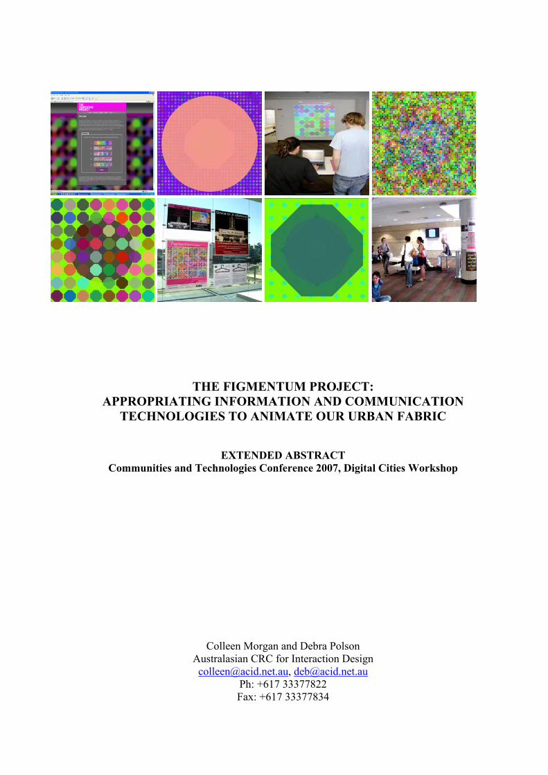
THE FIGMENTUM PROJECT:
APPROPRIATING INFORMATION AND COMMUNICATION TECHNOLOGIES TO ANIMATE OUR URBAN FABRIC
EXTENDED ABSTRACT Communities and Technologies Conference 2007, Digital Cities Workshop
Colleen Morgan and Debra Polson Australasian CRC for Interaction Design [email protected], [email protected]
Ph: +617 33377822 Fax: +617 33377834
KEY WORDS: Imagined communities, place attachment, information and communication technologies (ICTs) INTRODUCTION This paper explores how we may design located information and communication technologies (ICTs) to foster community sentiment. It focuses explicitly on possibilities for ICTs to create new modalities of place through exploring key factors such as shared experiences, shared knowledge and shared authorship. Modalities of place refer to the process by which numerous social, cultural, functional and emotional operators shape individual comprehension of place (Sandin, 2003). To contextualise this discussion in a real world setting, this paper presents FIGMENTUM, a situated generative art application that was developed for and installed in a new urban development. Importantly FIGMENTUM aims to trigger emotional and representational imagined communities. Unlike many current community based urban informatics that take the form of online community notice boards, user profiles and the like, FIGMENTUM is a non-authoritative, non-service based application. Instead of service-based ICT applications, our research focuses on the emotional and highly intangible cognitive processes that contribute to imaginings of community solidarity. It also emphasises the need for community based ICTs to inherently provide motivating factors for social interaction within communities. An evaluation of FIGMENTUM reveals the critical need for place-based ICT applications to be custom designed to suit the social, cultural, spatial, technical and temporal characteristics of individual sites to successfully augment experiences of place. Although this field is very much in its infancy, it is clear that new ICT applications have the potential to be extremely valuable tools for animating our urban fabric. This paper works towards a theory for designing creative place-based applications that may provide enriched experiences within a community. To design applications that may foster urban communities we must first work from a framework for understanding peoples’ relationships to place. To construct this framework, this paper explores the notions of place attachment and imagined communities. This paper also examines how social, cultural, functional and emotional operators contribute to experiences or ‘modalities’ of place. Understanding how modalities of place are constructed with these operators allows us to embed the knowledge developed from our framework into the process of designing and implementing community based ICTs. PLACE ATTACHMENT AND IMAGINED COMMUNTIES The concept of place attachment is a valuable tool for developing a framework for understanding people’s relationships to place as it refers to the emotional, functional, and social ties people develop within a community and towards a particular place (Hummon, 1992). There are a number of key aspects of peoples’ attachment to places. For this study we have identified them as community satisfaction, community attachment, and imagined community identity (Hummon, 1992: 254). Community satisfaction refers to how members are able to consciously view their community. In large part community satisfaction can be seen as functional attachment to place and is categorised in reference to objective community characteristics such as housing quality, recreational facilities,
size, and population density (Hummon, 1992: 255). Community attachment refers to “the study of emotional investment in place” (Hummon, 1992: 256). Often referred to as emotional place attachment, community attachment represents a significantly ontological facet of place attachment and is determined by subjective characteristics of individual experience. This form of place attachment is chiefly determined by length of residency, social involvement, organisational membership, and proximity to friends and family. The third aspect, imagined community identity refers to a highly intangible perspective of place attachment. It “explores the ways locales are imbued with personal and social meanings, and how such symbolic locals can serve in turn as an important sign or locus for the self” (Hummon, 1992: 258). The formation of this aspect of place attachment is largely an unconscious process for community members and groups and therefore is the least understood or clear aspect of place attachment (Hummon, 1992). While this aspect is the most difficult to define and understand, it is the aspect that deserves most attention when designing for community engagement. It is argued here that the development of an imagined community identity provides a motivating foundation for social interaction and as such it is essential that community ICTs foster imagined community identities. Benedict Anderson’s notion of an imagined community is a concept largely overlooked in conceptualisations of place attachment although provides valuable insights into the highly intangible aspects of peoples’ attachment to place. Anderson writes, “all communities larger than primordial villages of face-to-face contact (and perhaps even these) are imagined…it is imagined because the members of even the smallest nation will never know most of their fellow-members, meet them, or even hear of them, yet in the minds of each lives the image of their communion” (1983: 15). It is suggested that it is this communion that underpins peoples’ motivation to become emotionally invested and socially active in their community. Theorisations of imagined communities identify several key contributors to this strong image of communion; shared experience, shared knowledge, shared ownership and delimitated community boundaries. In order to foster community imaginings and motivate social interaction, ICTs must be designed to afford each of these key contributors. TECHNOLOGY, COMMUNITY, AND MODALITIES OF PLACE Identifying the operators that construct modalities of place allows us to understand how ICTs may afford these key contributors. As highlighted in the above discussion, the ability to share within a community is critical to the creation of a strong sense of community, be it sharing information, ownership or an experience itself. The principle ways in which ICT applications facilitate this sharing is through the one-to-many, many-to-many, synchronous, and asynchronous forms of communications made possible mostly by the Internet. While there exists extensive evidence that these forms of communication have facilitated the creation of endless numbers of online communities formed around topics of shared interest (Rheingold, 1994; Turkle, 1997) we are yet to successfully grasp how these vehicles for sharing may promote communities around place rather than around topics of shared interest. It is argued here that in order to understand of the relationship between ICTs and fostering placed-based communities, we must focus upon the possibilities for technologies to create new modalities of place. Modalities of place are created through a process by which social, cultural, functional and emotional operators shape individual comprehension of place (Sandin, 2003). We must consider what
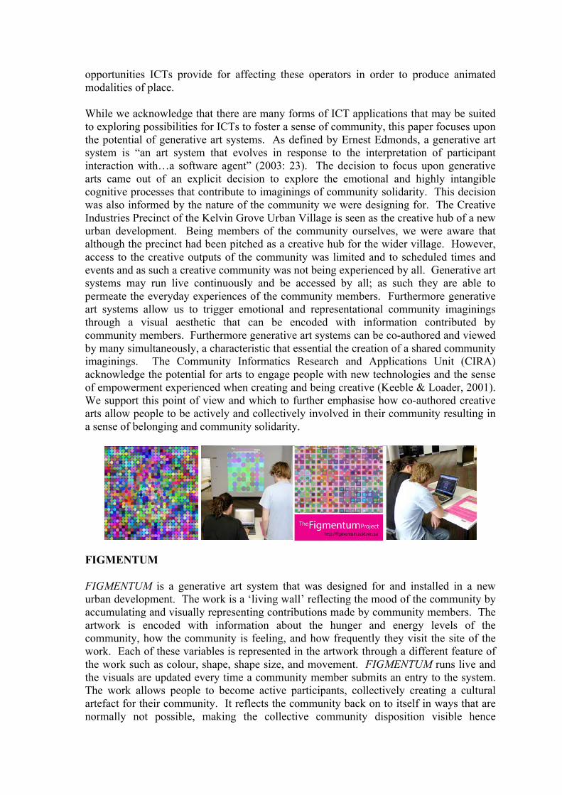
opportunities ICTs provide for affecting these operators in order to produce animated modalities of place. While we acknowledge that there are many forms of ICT applications that may be suited to exploring possibilities for ICTs to foster a sense of community, this paper focuses upon the potential of generative art systems. As defined by Ernest Edmonds, a generative art system is “an art system that evolves in response to the interpretation of participant interaction with…a software agent” (2003: 23). The decision to focus upon generative arts came out of an explicit decision to explore the emotional and highly intangible cognitive processes that contribute to imaginings of community solidarity. This decision was also informed by the nature of the community we were designing for. The Creative Industries Precinct of the Kelvin Grove Urban Village is seen as the creative hub of a new urban development. Being members of the community ourselves, we were aware that although the precinct had been pitched as a creative hub for the wider village. However, access to the creative outputs of the community was limited and to scheduled times and events and as such a creative community was not being experienced by all. Generative art systems may run live continuously and be accessed by all; as such they are able to permeate the everyday experiences of the community members. Furthermore generative art systems allow us to trigger emotional and representational community imaginings through a visual aesthetic that can be encoded with information contributed by community members. Furthermore generative art systems can be co-authored and viewed by many simultaneously, a characteristic that essential the creation of a shared community imaginings. The Community Informatics Research and Applications Unit (CIRA) acknowledge the potential for arts to engage people with new technologies and the sense of empowerment experienced when creating and being creative (Keeble & Loader, 2001). We support this point of view and which to further emphasise how co-authored creative arts allow people to be actively and collectively involved in their community resulting in a sense of belonging and community solidarity.
FIGMENTUM FIGMENTUM is a generative art system that was designed for and installed in a new urban development. The work is a ‘living wall’ reflecting the mood of the community by accumulating and visually representing contributions made by community members. The artwork is encoded with information about the hunger and energy levels of the community, how the community is feeling, and how frequently they visit the site of the work. Each of these variables is represented in the artwork through a different feature of the work such as colour, shape, shape size, and movement. FIGMENTUM runs live and the visuals are updated every time a community member submits an entry to the system. The work allows people to become active participants, collectively creating a cultural artefact for their community. It reflects the community back on to itself in ways that are normally not possible, making the collective community disposition visible hence
intensifying opportunities for shared imaginings and increased solidarity. It is important to acknowledge that in its current state FIGMENTUM is the first iteration in a continuing cycle of iterative design and action research and that future refinement will be required in order satisfy the aims of our research. An evaluation of FIGMENTUM reveals the critical need for community based ICTs to be custom designed to successfully create positively animated modalities of place. From our observational data, it became evident that along with the social, cultural, functional and emotional operators that contribute to experiences of place, the technical and temporal aspects of the site also had a significant impact upon how the work was received and how much people were prepared to invest in interacting with the work. Most notably the functionality and temporality of the site were seen to limit people’s engagement with the work. This underlines the need for the process of designing place-based ICTs to entail close consideration of the operators contributing to current modalities of a place, how they may effect the reception of the ICT and how they can be altered to animate the community. CONCLUSION The creation and evaluation of FIGMENTUM produced valuable research outcomes, revealing some of the processes required to foster community imaginings with ICTs. The Digital Cities workshop will provide us with an opportunity to share our research findings with others in the field and to further discuss the complexities and realities of embedding ICTs in communities. We wish to extend our research by considering the limits and potentials of community based ICTs, in particular focusing upon the process of implementing ICTs for the creation of new modalities of place. REFERENCES Anderson, B. 1983. Imagined Communities: Reflections on the Origin and Spread of Nationalism. London: Verso. Edmonds, E. 2003. Logics for Constructing Generative Art Systems. Digital Creativity, 14 (1): 23-28. http://gateway.library.qut.edu.au/login?url=http:// search.ebscohost.com/login.aspx?direct=true&db=inh&AN=7647583&site=ehost-live (accessed April 23, 2006, from EBSCOhost: Inspec database). Hummon, D. 1992. Community Attachment: Local Sentiment and Sense of Place. In Place Attachment, eds. I. Altman and S. M. Low, 253-278. New York: Plenum Press. Keeble, L. & Loader, B. D. 2001. Community Informatics: Shaping Computer-Mediated Social Relations. New York: Routledge. Rheingold, H. 1994. The Virtual Community: Homesteading on the Electronic Frontier. New York: Harper Perennial. Sandin, G. 2003. Modalities of Place: On Polarisation and Exclusion in Concepts of Place and in Site-Specific Art. Lund, Sweden: Lund University.

Turkle, S. 1997. Life on the Screen: Identity in the Age of the Internet. London: Phoenix.
Smart Signs in the City: Designing Social Space for the Digital Lifestyle
Introduction
If “physical proximity and everyday movement are still the a priori grounds upon which
much of daily life is founded” (Bull 2004, 290), then one must question what public life looks
like in a society that increasingly relies on mobile communication technology. It is conceivable
that the active cell phone user, immersed in the private bubble of sound that Bull observes, may
stroll down a lively, urban street and yet pass up chance meetings with passersby. A private
bubble of connection with distant others diminishes an appreciation for the cell phone user’s
physical location, resulting in public space that Bull and others would describe as placeless (e.g.
Wood 2003, Goldberger 2003).
A partial relaxation of this trend towards privatism is found in locative technology,
namely Global Positioning System (GPS), which now enables mobile social networking via the
cell phone. Users are alerted when friends or potential matches are close by. Although
capitalizing on physical proximity, these new applications nonetheless disrupt everyday patterns
of movement, by inducing a type of controlled chance in public space. Not surprisingly,
researchers apply the term “networked individualism” to the evolving mobile lifestyle (Wellman,
et al. 2003). In a world increasingly mediated by mobile communication technology, what are
the implications for the design of social public space?
Urban sociologists of the Chicago school of thought have continually located the urban
streets as the place for stumbling upon chance meetings, raising public questions, and building
social capital (e.g. Jacobs 1961, Lofland 1998, Mitchell 2003). Given certain features of the
built environment, such as a mix of commercial uses and many intertwining streets, Jacobs
demonstrates how people will naturally cross paths with diverse others and develop an informal
social support system. Whyte (1980) and Oldenburg (1989) similarly identify spatial features
that draw people together in pure sociability, by way of triangulation and “third place”-making,
respectively. At the time of these landmark studies, however, mobile media technologies were
not yet part of the equation. Considering how the cell phone is nearly a permanent fixture on the
body, new categories of design are warranted, to understand how space may still amplify
opportunities for chance interactions among urban, digital dwellers.
A fundamental characteristic of the cell phone is that it can be used in virtually any space,
regardless of the mix of venues or pattern of streets. This study will uncover how another
variable, that is signage, may take up the zoning of digital behavior in public space. From street
signs staked in the ground to digital signs on the scale of entire building facades, these publicly
displayed messages increasingly regulate or involve digital activity in the public realm. On one
end of the spectrum are signs declaring no-cell-phone zones, and on the other are places that
require the cell phone to interact with digital architecture of the streetscape, towards both
individual and community benefits. This study aims to identify and organize spaces of varying
sociality that are produced by the messages of signs, and through examining these opportunities
and building upon the lessons of urban sociology, I will propose updated design policies that
reconcile virtual socialization with physical socialization in public space.
Mobile Communication Technology
With GPS now built into most cell phones, mobile social networking offers the physical
embodiment of MySpace in public space. On the surface, it is reasonable to argue that Jacobs’
theories of urban sociology still carry much weight, for these locative applications are only as
useful and interesting as the number and mix of people using public space. Jacobs’ real aim,
however, is not only to encourage people to spend time in public, but moreover to exchange
friendly greetings and glances, to supply eyes to the streets in creation of informal support and
community safety. Instead, eyes are focused downward in the silent use of locative technology
on the cell phone screen and keypad. This averted gaze of cell phone users adds a visually
closed layer to their already private bubbles.
With eyes and ears occupied by mobile communication technology, users render the
designed environment less potent in its ability to help structure chance interactions and build
community. Akin to fears of a child glued to the television screen, cell phone users may deprive
themselves of pure socialization with co-present others. Furthermore, the ability to know one
another’s location permits a risk aversion, the means to tailor one’s public path to the spatial
distribution of known, desirable others – a controlled chance as I earlier suggested. While I do
not discount the promises of mobile media to forge connections in new and sometimes beneficial
ways, I choose to focus here on the question: what of space? How may urban designers achieve
a healthy balance of the digital and the physical in a social world?
Control by Design
In the mind of a Chicagoan ethnographer, every street has the potential to be a lively,
pedestrian friendly Main Street, welcoming of surprises. The characteristics of Oldenburg’s
“third place” and of Whyte’s triangulation, together, supply particularly useful concepts for this
current study of social space.
For Oldenburg, the “third place” is the local hangout – the bar, the beauty parlor, the
Main Street – places of pure sociability away from the other two places of home and work. The
“third place” has value, according to Oldenburg, for the informal support system it provides, and
in that, a relief from an otherwise taxing day. Social status is checked at the door of a successful
“third place,” and strangers interact as though they were familiar. If verbal interaction, in
particular, is the major pleasure of the “third place,” then the cell phone serves to disrupt the
momentum of a physically present, social atmosphere. Without new categories of public space
designs that I hope to provide, “third places” and cell phones do not readily click.
In the same way that “third places” encourage pure sociability, Whyte defines
triangulation as the “process by which some external stimulus provides a linkage between people
and prompts strangers to talk to each other as though they were not” (94). Street performances
and public sculptures are instruments of triangulation, spontaneously producing a crowd of
passersby who, at least momentarily, act like a family, but with none of the entanglements. Can
triangulation operate if eyes or ears are occupied by the cell phone? On the other hand, what if
an instrument of triangulation demands attention? Public signage does just that, displaying the
rules that all users of a particular public space must observe. To the extent that signs regulate or
involve the digital lifestyle, place-based activities for the cell phone user are born.
Signs in the City
Signs provide among the most visible information in the built environment, assisting with
such indispensable functions as navigation and place-marking. Signs reflect a formal rulebook
for the zoning of activities in various public places. In Learning from Las Vegas, Venturi, et al.
(1977) argue in favor of signs for providing explicit, comprehensible symbols to a culture on-the
go. Furthermore, unlike the television and its TIVO, the Internet and its spam filter, signs in
public are unavoidable. Signs stand a chance to control what users of public space see, do, and
talk about.
Signs organize new and often conflicting practices in public, clarifying spaces of traffic,
smoking, littering, loitering, skateboarding, and so on. Increasingly, signs also regulate space for
mobile media users and, thus, provide a window into the digital lifestyle for this analysis.
The spectrum of signage contexts and formats in the current outdoor media landscape
presents different ways of interfacing with the cell phone user. The message of a sign staked in
the ground designates, by default, its immediate vicinity unless more information is supplied.
Signs also integrate advanced display technologies. Digital video monitors on the sides of
buildings and transportation portals supply messages to passersby. Billboards, building facades,
and entire buildings for that matter, incorporate video, light-emitting diode (L.E.D.) grids, and
projection technologies to cast messages into their adjacent public space, notable examples of
which appear in Times Square. Additionally, there are increasing opportunities for pedestrians
to use their cell phones to interact with the publicly displayed messages of digital signs.
Through wireless Internet, Bluetooth technology, and text messaging, cell phone users may
acquire and share information with the computer database of a digital billboard, which in turn
may customize its displayed message for the user, and for all the public. These interactions
present opportunities to stop mobile media users in their tracks and to reorient them to physical
space and all its social potential.
Using a grounded theory approach, this study aims to sort the public spaces of varying
sociality that are produced by signs. I focus on signs that display text and visuals to regulate or
involve the use of cell phones. Examples are collected from my own observations in public
space, conversations with people who propagate such signs, and readings about interactive sign
technologies.
Preliminary Findings
Through the increasing propagation of no-cell-phone signs as well as cell phone booths in
public spaces, these sign-spaces primarily frame the cell phone as a source of distraction that
should be contained in certain spaces. In contrast, signs may also embrace and leverage the
digital lifestyle through interactive architecture of the streetscape.
The public displays of digital billboards, for example, increasingly invite passersby to
interact with them via their cell phones, such as to provide personal information or queries that
the billboard uses to produce a customized display of information for the user. Such an
interaction benefits the user additionally by providing a legible, large-scale surface of
information, as opposed to the often crammed, small-scale screen of the personal mobile device.
While many of these interactive opportunities focus on building individual, brand relationships
between consumers and marketers, digital signs may also amplify socialization in public spaces
by proactively sorting and displaying the matching profile information of co-present users. The
public display becomes an instrument of triangulation, sparking conversation between passing
strangers based on their mutual interests. This social cell phone zone effectively creates a source
of automated triangulation in public space.
Experimental research with this type of sign has been conducted by McCarthy (2002) at
the Intel Research Laboratory and by Churchill, et al. (2003) at the Fuji Xerox Palo Alto
Laboratory. My study dissects their prototypes: the GroupCast and Plasma Poster networks,
respectively. Although both look only at socialization-by-sign opportunities in small, relatively
predictable spaces of the workplace and through means of identification other than by cell
phones, studies are exploring the application of these signs in more typical “third places,” like
bars and cafes, along with the possibility of identification via the cell phone (Paek, et al. 2004).
These new applications are not without complications, such as how to encourage public
participation beyond the comfortable anonymity of virtual socialization. In this project, I will
discuss this and propose a strategic deployment of the various signs in public space to
accommodate the digital lifestyle, maintain “third places,” and to amplify socialization. In my
discovery of how shared space interacts with the digital lifestyle, public signage systems strike a
symbiosis with cell phones. Whether as a virtual mouse to control a custom design on a digital
billboard, or as a GPS identification tag that feeds an instance of automated triangulation, the cell
phone retains value in my search for place-based opportunities.
In light of my findings, this project will conclude by engaging the writings of Andrejevic
(2005) and others, in discussing the evolving role of ubiquitous computing and “smart”
contextually aware architecture of the streetscape. In summary, my study reveals how a
symbiosis of new technologies in public space may bring about face-to-face surprises of mutual
interest among strangers, reawakening community socialization opportunities and reorienting a
digital people to the power of place.
References
Andrejevic, M. (2005). Nothing Comes Between Me and My CPU: Smart Clothes and
‘Ubiquitous’ Computing. Theory, Culture & Society (22) 3, 101-119.
Bull, M. (2004). To Each Their Own Bubble: Mobile Spaces of Sound in the City. In N. Couldry
and A. McCarthy (Eds.), Mediaspace: Place, Scale and Culture in a Media Age, New
York: Routledge, 275-293.
Churchill, E. F., Nelson, L., & Denoue, L. (2003). Multimedia Fliers: Information Sharing with
Digital Community Bulletin Boards. Proceedings of Communities and Technologies,
Kluwer Academic Publishers.
Goldberger, P. (2003). Disconnected Urbanism. Metropolis Magazine. Retrieved April 7, 2007
from http://www.metropolismag.com/cda/story.php?artid=254.
Hampton, K. (2003). Neighboring in Netville: How the Internet Supports Community and Social
Capital in a Wired Suburb. City & Community (2) 4, 277-311.
Jacobs, J. (1961). The Death and Life of Great American Cities. New York: Vintage Books.
Lofland, L. H. (1998). The Public Realm: Exploring the City’s Quintessential Social Territory.
New York: Aldine De Gruyter.
McCarthy, J. F. (2002). Using Public Displays to Create Conversation Opportunities. Paper
presented at workshop on Public, Community, and Situated Displays at the ACM
Conference on Computer Supported Cooperative Work, November 18, New Orleans.
Mitchell, D. (2003). The Right to the City: Social Justice and the Fight for Public Space. New
York: Guilford.
O’Hara, K., Perry, M., Churchill, E., and Russell, D. (Eds.). (2003). Public and Situated
Displays: Social and Interactional Aspects of Shared Display Technologies. Dordrecht:
Kluwer Academic Publishers.
Oldenburg, R. (1989). The Great Good Place: Cafes, Coffee Shops, Community Centers, Beauty
Parlors, General Stores, Bars, Hangouts and How They Get You Through the Day. New
York: Paragon House.
Paek, T., Agrawala, M., Basu, S., Drucker, S., Kristjansson, T., Logan, R., Toyama, K., &
Wilson, A. (2004). Toward Universal Mobile Interaction for Shared Displays. Paper
presented at CSCW’04, November 6-10, Chicago.
Venturi, R., Brown, D. S., and Izenour, S. (1977). Learning from Las Vegas: The Forgotten
Symbolism of Architectural Form. Cambridge: MIT Press.
Wellman, B., Quan-Haase, A., Boase, J., Chen, W., Hampton, K., de Diaz, I. I., & Miyata, K.
(2003). The Social Affordances of the Internet for Networked Individualism. Journal of
Computer-Mediated Communication (8), 3.
Whyte, W. H. (1980). The Social Life of Small Urban Spaces. New York: Project for Public
Spaces.
Wood, Andrew. (2003). A Rhetoric of Ubiquity: Terminal Space as Omnitopia. Communication
Theory (13) 3, 324-344.
Bio:
Craig Trachtenberg is a doctoral student at the Annenberg School for Communication at the
University of Pennsylvania, where he studies the social aspects of emerging media and public
space. Before returning to school, he worked professionally in the theatrical, architectural, and
urban design industries. Craig’s undergraduate degree in Digital Media Design, also from
UPenn, integrated computer science with digital art and the psychology of visual
communication. His anticipated dissertation topic and long-term interests center on social
computing.

1
WIKICITY: REAL-TIME LOCATION-SENSITIVE TOOLS FOR THE CITY
Francesco CALABRESE SENSEable City Laboratory Massachusetts Institute of Technology 77 Massachusetts Avenue, Cambridge, MA 02139, U.S.A Tel: 1-617-2537926 Fax: 1-617-2588081 E-mail: [email protected]
Kristian KLOECKL SENSEable City Laboratory Massachusetts Institute of Technology 77 Massachusetts Avenue, Cambridge, MA 02139, U.S.A Tel: 1-617-2537926 Fax: 1-617-2588081 E-mail: [email protected]
Carlo RATTI SENSEable City Laboratory Massachusetts Institute of Technology 77 Massachusetts Avenue, Cambridge, MA 02139, U.S.A Tel: 1-617-2537926 Fax: 1-617-2588081 E-mail: [email protected]
People moving and acting in a city base their decisions on information that is in most cases not synchronized with the time and place they find themselves in when taking that decision. How often have you arrived at the airport just to find out that your flight has been delayed, been surprised by a traffic jam, found that a product is out of stock or a service operator busy at the moment you needed it. In the same way, a person acting in a city contributes herself to dynamics of which others are not aware of when making their decisions. Looked upon in this way a city resembles what Deleuze and Guattari describe as a "rhizome" (Deleuze & Guattari, 1977). The rhizome is a philosophical network structure where every part is necessarily connected with every other part of the system. There are no preferential connections because every connection alters the overall network structure. As a consequence, the rhizome can not be plotted since the plotting action itself is part of the rhizome and thus in the very moment of plotting its structure, the structure changes. The WikiCity project, in a similar way, is concerned with the real-time mapping of city dynamics. This mapping however is not limited to representing the city but instead becomes instantly an instrument for city inhabitants to base their actions and decisions upon in a better informed manner. In this way the real-time map changes the city context as well as that altered context changes the real-time map accordingly. This with the ultimate aim of leading to an overall increased efficiency and sustainability in making use of the city environment. In order to identify the functional elements needed to construct such an instrument we chose the real-time control system as an analogy to start with. In the past decades, real time control systems have been developed for, and deployed, in a variety of engineering applications. In so doing, they have dramatically increased the efficiency of systems through energy savings, self-organization/repair, regulation of the dynamics, increased robustness and disturbance tolerance. A concrete challenge we aim to tackle in this paper is applying the real-time control
2
theory and practice to cities in order to reduce the inefficiencies of present day urban systems and open the way to a more sustainable urban future. So in this paper we try to understand whether a city can be effectively modeled and controlled in real-time as a Cyber Physical System. Let’s examine the four key components of a real time control system: 1. entity to be controlled in an environment characterized by uncertainty; 2. sensors able to acquire information about the entity’s state in real time; 3. intelligence capable of evaluating system performance against desired outcomes; 4. physical actuators able to act upon the system to realize the control strategy. A city certainly fits the definition of point 1. Point 2 does not seem to pose particular problems: today’s deployment of a range of remote sensors in urban areas allows for unprecedented data collection and analysis. As an example, the Real Time Rome project1 developed a unique approach to real-time urban monitoring, based on the use of anonymous real-time data gathered from cellular phones and GPS devices. The project was able to collect the movement patterns of people and transportation systems, and their spatial and social usage of streets and neighborhoods. Information regarding further aspects are already collected continuously by distinct computing systems that track product and service availability, environmental values, climatic conditions, acoustic values, events,… What about points 3 and 4? How to actuate the city? Although the city already contains several classes of actuators such as traffic lights and remotely updated street signage, their range of use is currently limited. A much more flexible actuator would be the city’s own inhabitants: they represent a distributed actuation system in which each person pursues his individual interest in cooperation and competition with others, with the overall behavior of the system governed by the interaction between individuals. People can also clearly form part of the overall intelligence of the control system. Towards the above goal, the WikiCity project can be thought of as adding further, interaction-oriented layers to a real-time map of the city and making location and time-sensitive information accessible to users, allowing them full control on the database, onto which they can upload and download data. This paper will present a new platform for storing and exchanging data which are location and time-sensitive, making them accessible to users through mobile devices, web interfaces and physical interface objects. This platform enables people to become distributed intelligent actuators and thus prime actors themselves in improving the efficiency of urban systems. The system is based on a common, semantically defined, format for interchange of locational data and a distributed platform able to collect and manage such data in real time. The latest W3C trends, including Semantic Web (Berners-Lee, Hendler, Lassila, 2001) and Web Services Composition (BPEL4WS, 2007), provide the basis for developing and maintaining such platform. By deploying developments of the ‘Web 2.0’ and the ‘Semantic Web’ WikiCity can be
1 Real Time Rome is a partnership project between the MIT SENSEable City Laboratory and Telecom Italia that was presented at the Venice Biennale of Architecture, 2006, http://senseable.mit.edu/realtimerome/ (see Calabrese & Ratti, 2006).
3
a significant leap forward towards a pervasive ‘internet of things’ (ITS, 2005) to support human action and interaction. WikiCity is a work in progress. Attention during the coming months will be driven onto three main areas: Concepts and scenarios, System structure and implementation, Interface modality. A brief description of these research topics is given in the following, while detailed description of the developed work will be presented in the full paper. Concepts and scenarios WikiCity is about envisioning new application scenarios on the basis of a technology potential involved in location and time-sensitive information. As an instrument for developing applications for this new technology system we are systematically analyzing intersections between needs and opportunities of three element groups which we have identified and which are Agents, Environment and Technology features. On the basis of these analysis user scenario and storyboard creating will be instrumental for guiding on the one hand the technical implementation of the hard- and software and on the other to make best use of this very implementation. System structure and implementation The WikiCity project aims at adapting a common format for interchange of real-time location-based data and a distributed platform able to collect, manage and provide such data in real time. In this way the city’s most informative real-time map can be created, letting users broadcast their location and have site-specific information pushed on them per request. WikiCity can be divided into a number of manageable channels (layers) like mobility, events, aggregate information, and whatever is most useful and efficient for users to search and access the geospatial content they’re looking for. Instead of starting the implementation of the project by a top-down approach such as the definition of standards we consider a bottom-up approach in terms of a case study that allows for experimenting with the platform. For the development of WikiCity a city will be chosen whose local authority becomes a key partner and active agent in the entire process which then is open to and involves potentially all city inhabitants and businesses in the given metropolitan area. We aim at acquiring data from: 1. telecom operators, such as aggregate mobile phones location data and further users information; 2. public transport (bus, subway, train), such as vehicles' locations, paths and time schedules; 3. companies, which have real-time location information of a number of vehicles (e.g. car fleet management, taxi,…); 4. businesses, which want to provide services/products that are location-time sensitive; 5. local authorities, that can add information about upcoming events, activities or environmental conditions. 6. any private individual, that can upload information on general interest, on events, about requests or offerings.
4
We have also identified a software architecture for the development of WikiCity, composed of six main components: 1. Data authoring; 2. Data acquisition; 3. Data storage infrastructure; 4. Metadata engine; 5. Data extraction and processing; 6. User interface. Interface modality Just as important as the information is, that can be presented in various circumstances in relation to a city map, the very way the information is made accessible determines the effective outcome and relevant acceptance of the project as such. For this reason WikiCity explores different interface modalities that create connections between the virtual data and the actual physical world where these data is accessed by users. Interfaces to WikiCity can be more closely positioned to the built environment in terms of interior spaces (Desktop PC, Wall projections,...) and or outdoor spaces (info totem, facade display,...), they can be linked to moving vehicles (public transportation, car infotainment centre,...) or they can be closely located to the user himself (Smartphone, PDA, PC Laptop,...). Keywords: real-time city, location based service, urban dynamics, control system. Authors:
Francesco Calabrese Francesco Calabrese graduated in Informatics Engineering, cum laude, from the University of Naples Federico II, Italy, in February 2004. He is currently a Ph.D. student in Informatics and Automatics Engineering at the Department of Computer and Systems Engineering of the University of Naples Federico II, Italy, and a Visiting Ph.D. student at the SENSEable City Laboratory of the Massachusetts Institute of Technology, Cambridge, MA, USA, with a Tronchetti Provera fellowship, awarded by the Italy-MIT Consortium. His research interests include hybrids control systems, embedded control systems, CNC machines, real-time control systems, real-time analysis of telecom systems and urban dynamics. Kristian Kloeckl After having attended Architecture and Industrial Design degree courses in Austria, England and Italy, Kristian Kloeckl graduated at the Politecnico di Milano, Italy, with distinction. He is currently enrolled in the Design Science PhD program at the Iuav University of Venice, Italy, and a Visiting Ph.D. student at the SENSEable City Laboratory of the Massachusetts Institute of Technology, Cambridge, MA, USA. His research interests have covered areas such as product design in the urban context, medical design and connections design while he is also holding design classes in various institutes.
5
Besides his academic work he has been collaborating with leading design studios in Berlin and Milan before setting up his own design practice in 2003 in Venice. Carlo Ratti An architect and engineer by education, Carlo Ratti is Associate Professor of the Practice of Urban Technologies at the Massachusetts Institute of Technology, where he directs the SENSEable City Laboratory. The SENSEable City Laboratory is a new research initiative that explores how technology is transforming urban design and living; in less than three years it has set up several industrial partnerships and has claimed a number of patents. Carlo is also founding partner and director of carlorattiassociati, a rapidly growing architectural practice that was established in Turin, Italy, in 2002; the practice is currently involved in a number of architectural schemes, both nationally and internationally. Carlo graduated in structural engineering from the Politecnico di Torino and the Ecole Nationale des Ponts et Chaussies, later specializing in architecture with MPhil and PhD degrees from the University of Cambridge. He is a member of several professional organizations, including the Ordine degli Ingegneri di Torino, the Association des Anciens Eleves de l'Ecole Nationale des Ponts et Chaussees and the UK Architects Registration Board.
REFERENCES Berners-Lee T., Hendler J., Lassila O., (2001). The Semantic Web, Scientific
American, May. BPEL4WS, (2007). Business Process Execution Language for Web Services version
1.1, http://www-128.ibm.com/developerworks/library/specification/ws-bpel/ Calabrese F., Colonna M., Lovisolo P. Parata D., Ratti C., (2007). Real-Time Urban
Monitoring Using Cellphones: a Case-Study in Rome, IEEE Communications Magazine, submitted.
Calabrese F., Ratti C., (2006). Real Time Rome, Networks and Communication studies, vol.20, n.3/4.
Deleuze G., Guattari F., (1977). Rizoma. Pratiche Editrice, Parma-Luca. ITU, (2005). The internet of things. Report of the International Telecommunication
Union, Geneva.