Quick Look Handbook Onshore Louisiana Petroleum Producing Formations · PDF fileOnshore...
43
Quick Look Handbook Quick Look Handbook Onshore Louisiana Onshore Louisiana Petroleum Producing Formations Petroleum Producing Formations Donald A. Goddard Louisiana State University Center For Energy Studies
-
Upload
nguyenthuy -
Category
Documents
-
view
234 -
download
1
Transcript of Quick Look Handbook Onshore Louisiana Petroleum Producing Formations · PDF fileOnshore...
Quick Look HandbookQuick Look Handbook Onshore LouisianaOnshore Louisiana
Petroleum Producing FormationsPetroleum Producing Formations
Donald A. Goddard Louisiana State University Center For Energy Studies
1
QUICK LOOK HANDBOOK
ONSHORE LOUISIANA PETROLEUM PRODUCING FORMATIONS
Introduction
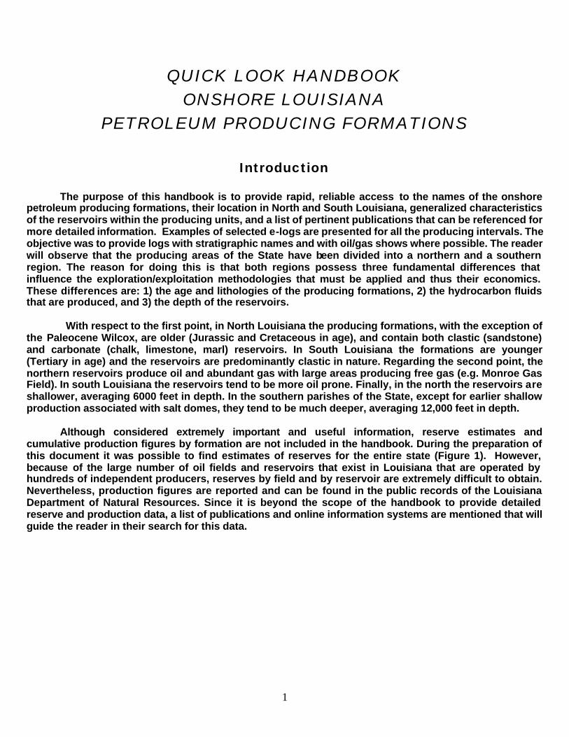
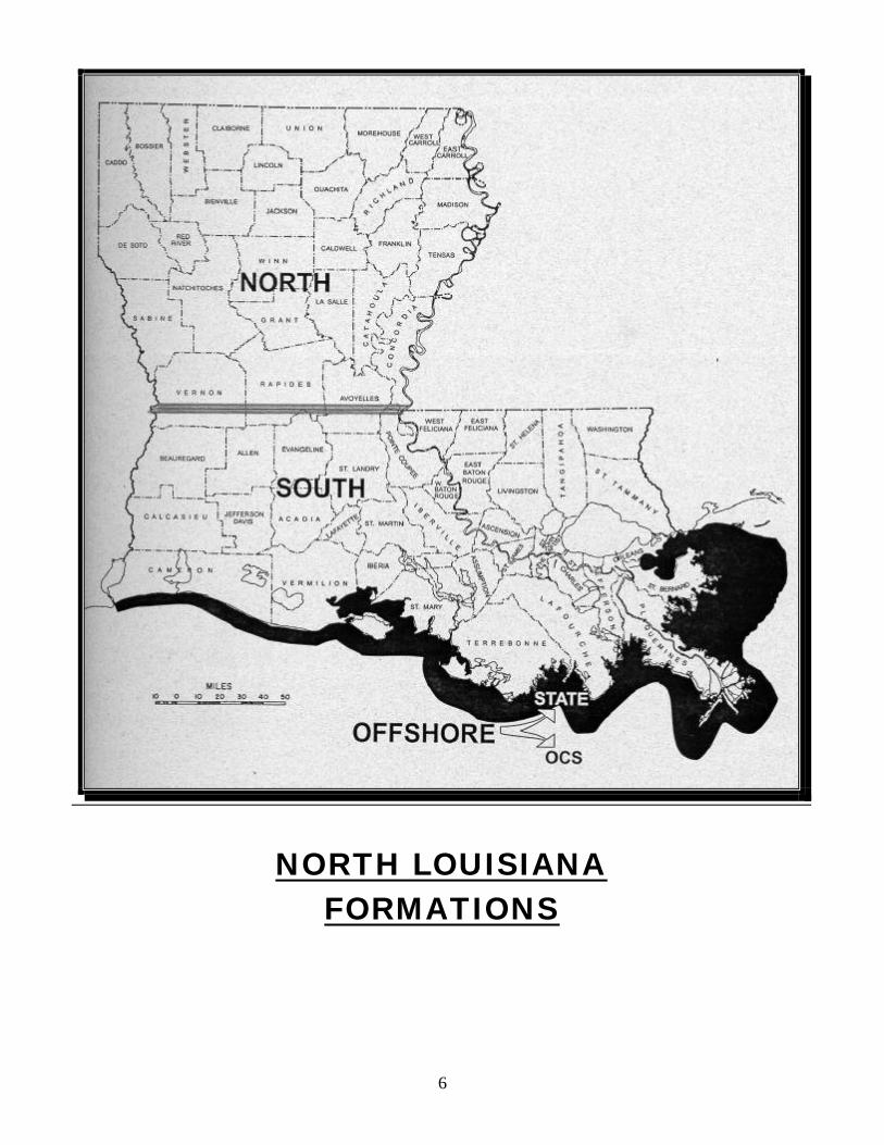
The purpose of this handbook is to provide rapid, reliable access to the names of the onshore petroleum producing formations, their location in North and South Louisiana, generalized characteristics of the reservoirs within the producing units, and a list of pertinent publications that can be referenced for more detailed information. Examples of selected e-logs are presented for all the producing intervals. The objective was to provide logs with stratigraphic names and with oil/gas shows where possible. The reader will observe that the producing areas of the State have been divided into a northern and a southern region. The reason for doing this is that both regions possess three fundamental differences that influence the exploration/exploitation methodologies that must be applied and thus their economics. These differences are: 1) the age and lithologies of the producing formations, 2) the hydrocarbon fluids that are produced, and 3) the depth of the reservoirs. With respect to the first point, in North Louisiana the producing formations, with the exception of the Paleocene Wilcox, are older (Jurassic and Cretaceous in age), and contain both clastic (sandstone) and carbonate (chalk, limestone, marl) reservoirs. In South Louisiana the formations are younger (Tertiary in age) and the reservoirs are predominantly clastic in nature. Regarding the second point, the northern reservoirs produce oil and abundant gas with large areas producing free gas (e.g. Monroe Gas Field). In south Louisiana the reservoirs tend to be more oil prone. Finally, in the north the reservoirs are shallower, averaging 6000 feet in depth. In the southern parishes of the State, except for earlier shallow production associated with salt domes, they tend to be much deeper, averaging 12,000 feet in depth. Although considered extremely important and useful information, reserve estimates and cumulative production figures by formation are not included in the handbook. During the preparation of this document it was possible to find estimates of reserves for the entire state (Figure 1). However, because of the large number of oil fields and reservoirs that exist in Louisiana that are operated by hundreds of independent producers, reserves by field and by reservoir are extremely difficult to obtain. Nevertheless, production figures are reported and can be found in the public records of the Louisiana Department of Natural Resources. Since it is beyond the scope of the handbook to provide detailed reserve and production data, a list of publications and online information systems are mentioned that will guide the reader in their search for this data.
2
Brief History The date that is given for the initiation of the petroleum industry in Louisiana is 1866. At this time, only seven years after Colonel Drake’s oil discovery on August 28, 1859, in Pennsylvania, the first exploratory well was drilled by hand in Calcasieu Parish. However, it was not until 1901 that the first commercial production began at Jennings in South Louisiana, with the drilling of the Scott Heywood well. In North Louisiana, the first oil production began in Caddo Parish in 1906. The huge Monroe Gas Field was discovered in 1916 near Monroe and covers parts of Union, Morehouse, and Ouachita Parishes. Drilling of the first well far offshore in the Gulf of Mexico, south of Morgan City, did not occur until 1947. Details of these and other events regarding Louisiana’s petroleum history have been well documented. Perhaps the two most interesting and thorough accounts about Louisiana’s earlier developments in our industry can be found in the following publications: French, T. M. and M. Lam, (1986), “Oil and Gas Production Industry In Louisiana, A Short History With Long Term Projections:” Louisiana Department of Natural Resources, Energy Division, Technology Assessment Division, 42 pp. Lindstedt, D. M., L. L. Nunn, et al (1991), “History of Oil and Gas Development in Coastal Louisiana:” Louisiana Geological Survey, Resource Information Series No. 7, 131 pp. Available Information Systems There are several online information systems containing oil and gas databases (wells, fields, production, etc.) that are easily accessible. Those considered to be the most complete for Louisiana are the following: Department of Natural Resources “SONRIS 2000 Integrated Applications.” Production data is from 1977 to the present. It functions well with Internet Explorer’s web browser, but with difficulty using Netscape. The web site is http://sonris-www.dnr.state.la.us Central Gulf Region/Petroleum Technology Transfer Council (CGR/PTTC) web site: http://www.cgrpttc.lsu.edu. In the Tech Transfer Section, oil and gas information for Louisiana is listed with production data reported from 1977 to 1999. “Louisiana Desk Top Well Reference (version 1999),” a CD that was prepared by the Louisiana Department Of Natural Resources, LSU Center For Energy Studies and LSU Basin Research Sector of the Louisiana Geological Survey. This CD can be purchased for $200 from the Central Gulf Region PTTC located at LSU. A National Data Base Of Geological Engineering, Production and Ultimate Recovery Data For U.S. Oil And natural gas Reservoirs, 1997: The Department of Energy’s Gas information System (GASIS).
3
Publications and Reports
Information regarding Louisiana’s petroleum producing formations and reservoirs is well documented in numerous technical publications and reports. The most important of these, and the sources of most of the data provided herein are the following: Transactions of The Gulf Coast Association of Geological Societies (GCAGS), 1951 – 2000. Reports of the Lafayette Geological Society: “Typical Oil and Gas Fields of Southwestern Louisiana,” vol 1, 1964; vol. 2, 1970; vol. 3, 1989. Reports of the New Orleans Geological Society: ”Oil and Gas Fields of Southeast Louisiana,” vol 1, 1965; vol. 2, 1967; vol. 3; 1983. Reports of The Shreveport Geological Society: “Reports of Selected Oil and Gas Fields of North Louisiana and South Arkansas,” Vol. III, no.1, 1951; Vol. lll, no. 2, 1953; Vol. lV, 1958; Vol. V, 1963; Vol. Vl, 1980; vol. Vll, 1987. Atlas of Major Central and Eastern Gulf Coast Gas Reservoirs, 1992, Sponsored by the Gas Research Institute and coordinated and edited by the Bureau of Economic Geology at The University of Texas at Austin. 88 pp. DOE publication DOE/ID 12842-1 “Pilot Oil Atlas for Louisiana, Final Report,” 1993, by A. D Bourgoyne, C. Kimbrell and W. Gao, Louisiana State University, 89 pp. Bulletins of the American Association Of Petroleum Geologists.
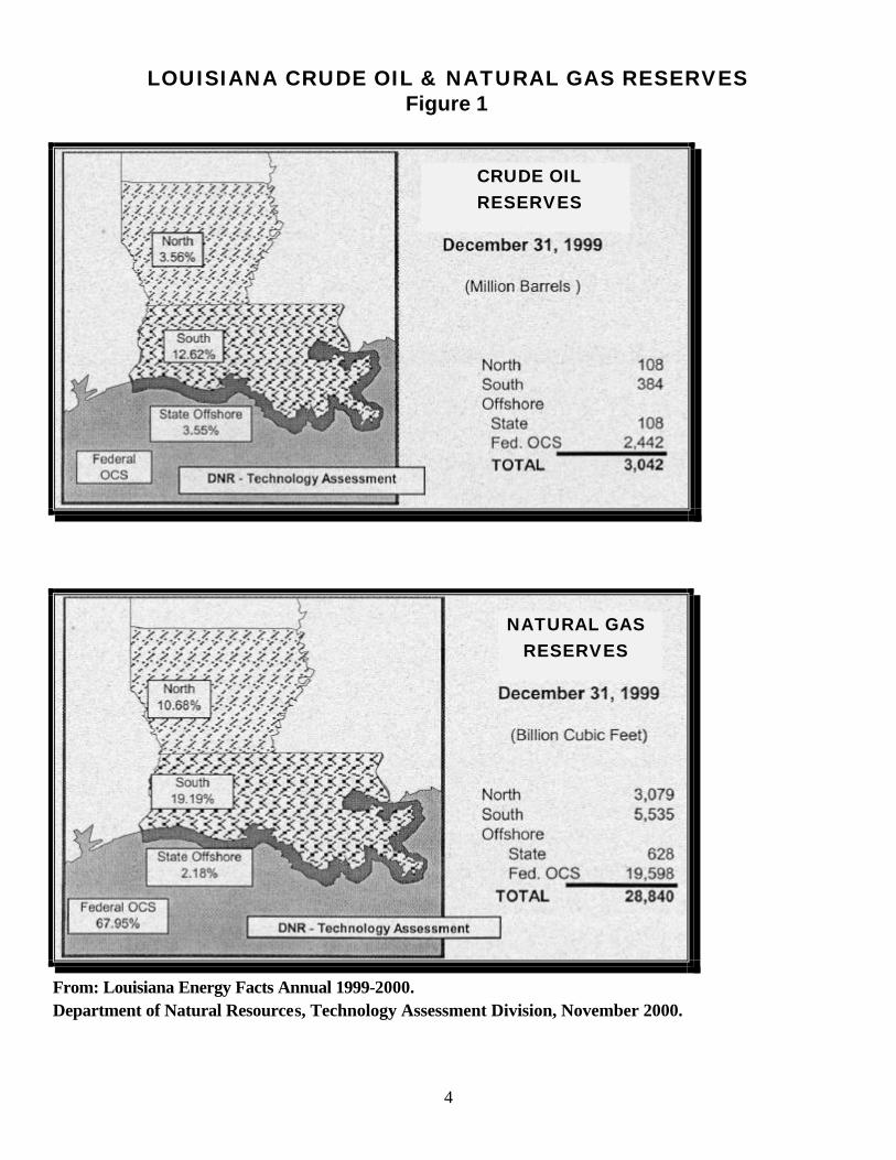
Reserve Estimates After more than one hundred years of petroleum activity, Louisiana today is the country’s largest producer of crude oil and condensate at 1.53 million barrels per day (MMBPD). Texas produces 1.42 MMBPD and Alaska approximately 1.0 MMBPD (Oil & Gas Journal, 06/15/2001). The natural gas resource base for the Gulf Coast States, including Louisiana, as of April 2001, was approximately 260 TCF. The oil resource base in this region was estimated to be 100 billion barrels (MMS National Assessment). Between 1960 and 2000, oil and gas reserve estimates for Louisiana have fluctuated widely. Reserve figures as high as 5.7 billion barrels of oil and 88 trillion cubic feet (TCF) of natural gas have been reported. As of the year 2000, conservative estimates of 3 billion barrels of oil and 29 TCF of gas are believed to exist in Louisiana (Figure 1). Because of the limitations with the reporting method of oil and gas produced, it is no easy task to obtain accurate estimates for cumulative production by field, or even by Parish.
4
LOUISIANA CRUDE OIL & NATURAL GAS RESERVES Figure 1
CRUDE OIL RESERVES
NATURAL GAS RESERVES
From: Louisiana Energy Facts Annual 1999-2000. Department of Natural Resources, Technology Assessment Division, November 2000.
5
Maps Available regional maps containing field and reservoir information are the following:
Oil & Gas Map of Louisiana, 1981. Published by the Department of Natural Resources and compiled by the Louisiana Geological Survey. Scale 1:380,160 (1 inch = 6 miles).
Geomap Company Executive Reference Maps, 1995, 1996.
1) Map 303, SW Louisiana, 1995. Scale: 1” = 28,000’
2) Map 304, SE Louisiana, 1995. Scale: 1” = 28,000’ 3) Map 310, S. Arkansas & N. Louisiana, 1996. Scale: 1” = 32,000 Acknowledgements
Louisiana State University Center for Energy Studies and the Central Gulf Region Petroleum Technology Transfer Council (CGR/PTTC) provided financial support for the publication of the document. The author is especially grateful to Ron Zimmerman from the Louisiana Geological Survey’s Basin Research Energy Section for his valued personal communications and discussions held during the preparation of the manual. Although the author is responsible for the contents of the manuscript, critical review and suggestions by Barbara Kavanaugh and Ron Zimmerman were very helpful in the organization of the text and of the data presented.
6
NORTH LOUISIANA FORMATIONS
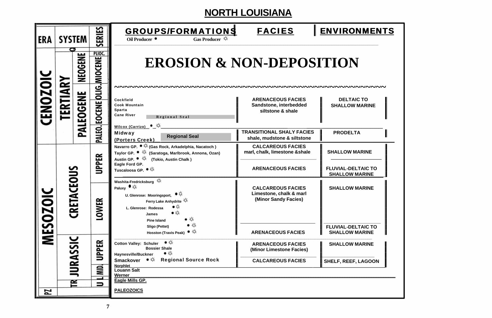
GROUPS/FORMATIONSGROUPS/FORMATIONS _____________________________________________________________________________________________________________________________
~~~~~~~~~~~~~~~~~~~~~~~~~~~~~~~~~~~~~~~~~~~~~~~~~~~~~ Cockfield Cook Mountain Sparta Cane River
Wilcox (Carrizo)__ _ ____________________________________________________________ ____________________________________
Midway (Porters Creek)__ ______________________________________________________________________________________ Navarro GP. (Gas Rock, Arkadelphia, Nacatoch )
Taylor GP. (Saratoga, Marlbrook, Annona, Ozan)
Austin GP. (Tokio, Austin Chalk ) Eagle Ford GP.
Tuscaloosa GP. _____________________________________________________________________________________________________________
Washita-Fredricksburg
Paluxy
U. Glenrose: Mooringsport,
Ferry Lake Anhydrite
L. Glenrose: Rodessa
James
Pine Island
Sligo (Pettet)
Hosston (Travis Peak) __________________________________________________________________________________________________________________________
Cotton Valley: Schuler Bossier Shale
Haynesville/Buckner
Smackover Norphlet______________________________________________________________________________________ __________________________________ Louann Salt Werner______________________________________________________________________________________________________________ Eagle Mills GP. PALEOZOICS
NORTH LOUISIANA
TRANSITIONAL SHALY FACIES shale, mudstone & siltstone
ARENACEOUS FACIES Sandstone, interbedded
siltstone & shale
Oil Producer Gas Producer
EROSION & NON-DEPOSITION
CALCAREOUS FACIES marl, chalk, limestone &shale ____________________________
ARENACEOUS FACIES
Regional Source Rock
FACIESFACIES ENVIRONMENTSENVIRONMENTS
ARENACEOUS FACIES (Minor Limestone Facies)
____________________________ CALCAREOUS FACIES
CALCAREOUS FACIES Limestone, chalk & marl
(Minor Sandy Facies) _______________________________ ARENACEOUS FACIES
DELTAIC TO SHALLOW MARINE
PRODELTA Regional Seal
R e g i o n a l S e a l
SHALLOW MARINE _____________________
FLUVIAL-DELTAIC TO
SHALLOW MARINE
SHALLOW MARINE
_____________________
FLUVIAL-DELTAIC TO SHALLOW MARINE
SHALLOW MARINE ____________________
SHELF, REEF, LAGOON
7
8
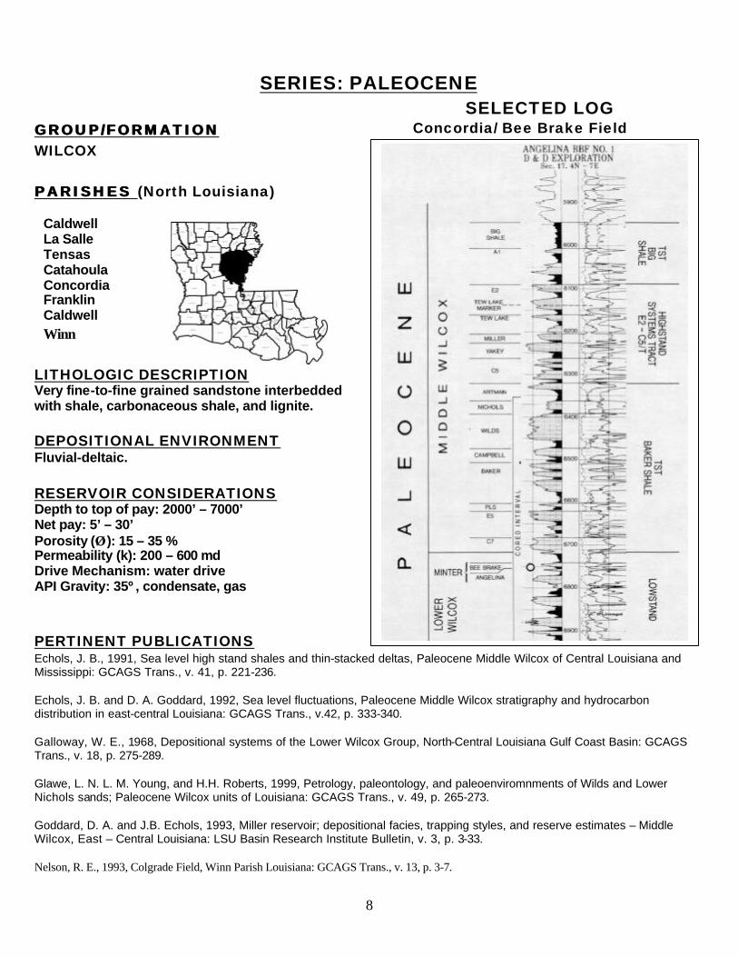
SERIES: PALEOCENE SELECTED LOG
GROUP/FORMATION GROUP/FORMATION WILCOX PARISHES PARISHES (North Louisiana)
LITHOLOGIC DESCRIPTION Very fine-to-fine grained sandstone interbedded with shale, carbonaceous shale, and lignite.
DEPOSITIONAL ENVIRONMENT Fluvial-deltaic. RESERVOIR CONSIDERATIONS Depth to top of pay: 2000’ – 7000’ Net pay: 5’ – 30’ Porosity (ÂÂ ): 15 – 35 % Permeability (k): 200 – 600 md Drive Mechanism: water drive API Gravity: 35º, condensate, gas
PERTINENT PUBLICATIONS Echols, J. B., 1991, Sea level high stand shales and thin-stacked deltas, Paleocene Middle Wilcox of Central Louisiana and Mississippi: GCAGS Trans., v. 41, p. 221-236. Echols, J. B. and D. A. Goddard, 1992, Sea level fluctuations, Paleocene Middle Wilcox stratigraphy and hydrocarbon distribution in east-central Louisiana: GCAGS Trans., v.42, p. 333-340. Galloway, W. E., 1968, Depositional systems of the Lower Wilcox Group, North-Central Louisiana Gulf Coast Basin: GCAGS Trans., v. 18, p. 275-289. Glawe, L. N. L. M. Young, and H.H. Roberts, 1999, Petrology, paleontology, and paleoenviromnments of Wilds and Lower Nichols sands; Paleocene Wilcox units of Louisiana: GCAGS Trans., v. 49, p. 265-273. Goddard, D. A. and J.B. Echols, 1993, Miller reservoir; depositional facies, trapping styles, and reserve estimates – Middle Wilcox, East – Central Louisiana: LSU Basin Research Institute Bulletin, v. 3, p. 3-33. Nelson, R. E., 1993, Colgrade Field, Winn Parish Louisiana: GCAGS Trans., v. 13, p. 3-7.
Caldwell La Salle Tensas Catahoula Concordia Franklin Caldwell Winn
Concordia/ Bee Brake Field
9
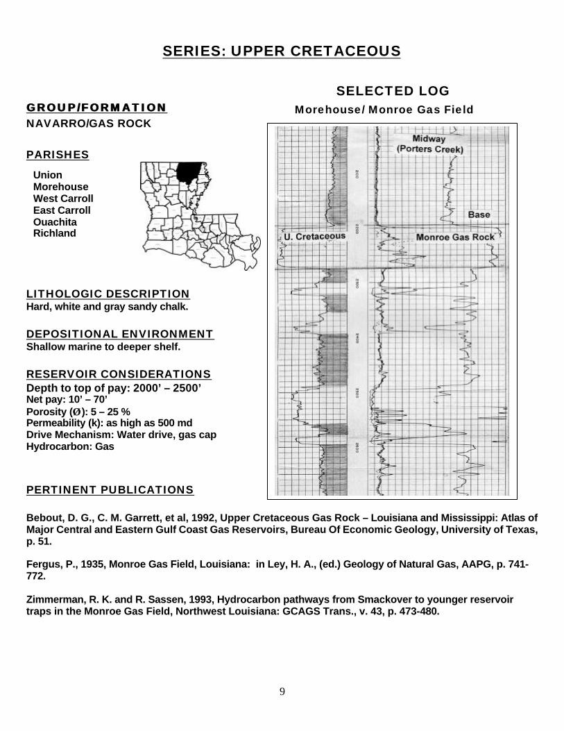
SERIES: UPPER CRETACEOUS
SELECTED LOG GROUP/FORMATION GROUP/FORMATION NAVARRO/GAS ROCK PARISHES
LITHOLOGIC DESCRIPTION Hard, white and gray sandy chalk. DEPOSITIONAL ENVIRONMENT Shallow marine to deeper shelf. RESERVOIR CONSIDERATIONS Depth to top of pay: 2000’ – 2500’ Net pay: 10’ – 70’ Porosity (ÂÂ ): 5 – 25 % Permeability (k): as high as 500 md Drive Mechanism: Water drive, gas cap Hydrocarbon: Gas PERTINENT PUBLICATIONS Bebout, D. G., C. M. Garrett, et al, 1992, Upper Cretaceous Gas Rock – Louisiana and Mississippi: Atlas of Major Central and Eastern Gulf Coast Gas Reservoirs, Bureau Of Economic Geology, University of Texas, p. 51. Fergus, P., 1935, Monroe Gas Field, Louisiana: in Ley, H. A., (ed.) Geology of Natural Gas, AAPG, p. 741-772. Zimmerman, R. K. and R. Sassen, 1993, Hydrocarbon pathways from Smackover to younger reservoir traps in the Monroe Gas Field, Northwest Louisiana: GCAGS Trans., v. 43, p. 473-480.
Union Morehouse West Carroll East Carroll Ouachita Richland
Morehouse/ Monroe Gas Field
10
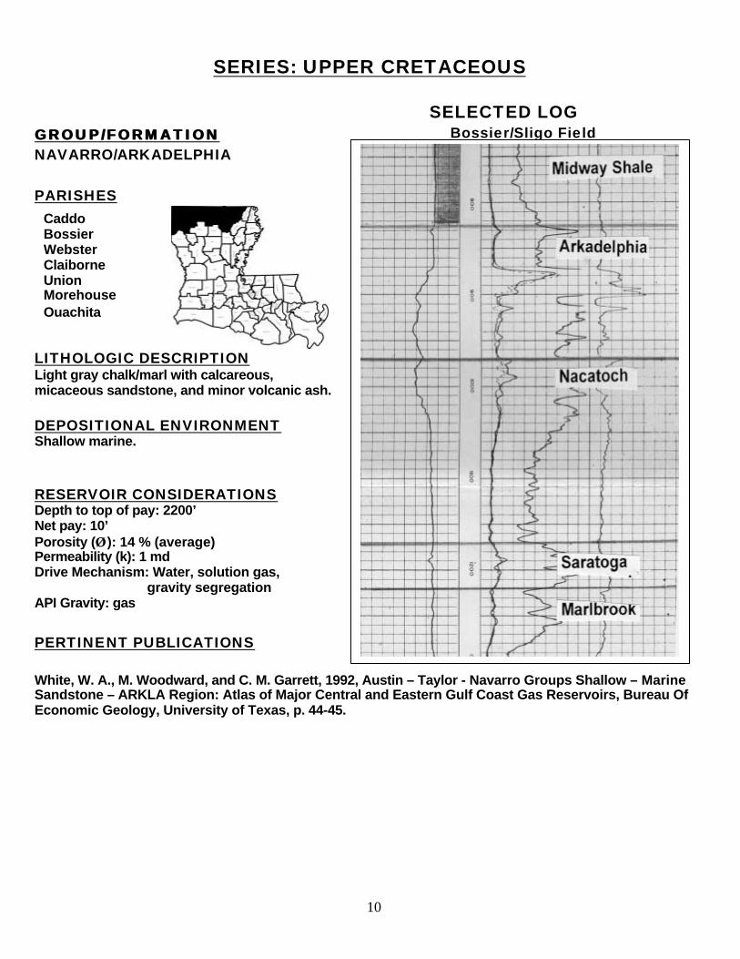
SERIES: UPPER CRETACEOUS SELECTED LOG GROUP/FORMATION GROUP/FORMATION NAVARRO/ARKADELPHIA PARISHES
LITHOLOGIC DESCRIPTION Light gray chalk/marl with calcareous, micaceous sandstone, and minor volcanic ash.
DEPOSITIONAL ENVIRONMENT Shallow marine. RESERVOIR CONSIDERATIONS Depth to top of pay: 2200’ Net pay: 10’ Porosity (ÂÂ ): 14 % (average) Permeability (k): 1 md Drive Mechanism: Water, solution gas, gravity segregation API Gravity: gas
PERTINENT PUBLICATIONS White, W. A., M. Woodward, and C. M. Garrett, 1992, Austin – Taylor - Navarro Groups Shallow – Marine Sandstone – ARKLA Region: Atlas of Major Central and Eastern Gulf Coast Gas Reservoirs, Bureau Of Economic Geology, University of Texas, p. 44-45.
Caddo Bossier Webster Claiborne Union Morehouse Ouachita
Bossier/Sligo Field

11
SERIES: UPPER CRETACEOUS
SELECTED LOG GROUP/FORMATION GROUP/FORMATION NAVARRO/NACATOCH PARISHES
LITHOLOGIC DESCRIPTION Medium to fine grained unconsolidated quartz sandstone, sandy limestone, clay, marl and shale. Sandstones are glauconitic, ashy and argillaceous.
DEPOSITIONAL ENVIRONMENT Shallow marine. RESERVOIR CONSIDERATIONS Depth to top of pay: 800’ – 2700’ Net pay: 15’ – 50’ Porosity (ÂÂ ): 28 % (average) Permeability (k): 200 – 2500 md Drive mechanism: water, solution gas API Gravity: gas PERTINENT PUBLICATIONS Cullum, T. M., 1963, Shreveport Field, Caddo and Bossier Parish, Louisiana: Shreveport Geological Society; Report on Selected North Louisiana and South Arkansas Oil and Gas Fields, vol. V, p. 184-188. White, W. A., M. Woodward, and C. M. Garrett, 1992, Austin – Taylor - Navarro Groups Shallow – Marine Sandstone – ARKLA Region: Atlas of Major Central and Eastern Gulf Coast Gas Reservoirs, Bureau Of Economic Geology, University of Texas, p. 44-45.
Caddo Bossier Webster Caiborne Union
Bossier/Simpson Lake Field
12
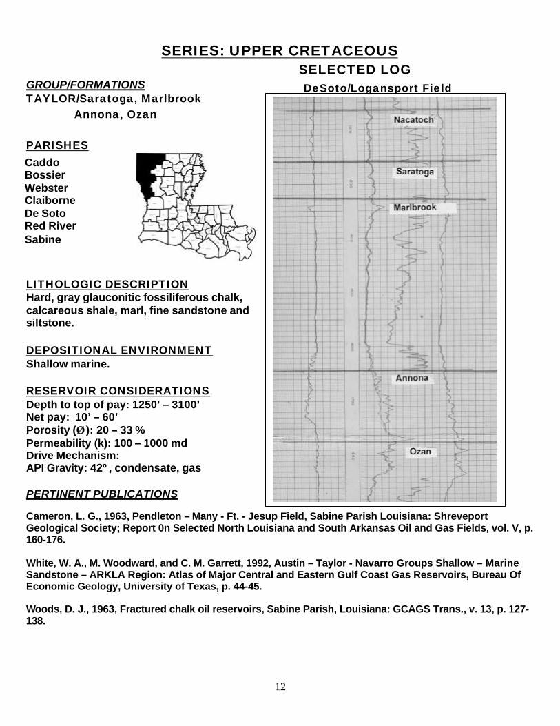
SERIES: UPPER CRETACEOUS SELECTED LOG GROUP/FORMATIONS TAYLOR/Saratoga, Marlbrook Annona, Ozan PARISHES
LITHOLOGIC DESCRIPTION Hard, gray glauconitic fossiliferous chalk, calcareous shale, marl, fine sandstone and siltstone. DEPOSITIONAL ENVIRONMENT Shallow marine. RESERVOIR CONSIDERATIONS Depth to top of pay: 1250’ – 3100’ Net pay: 10’ – 60’ Porosity (ÂÂ ): 20 – 33 % Permeability (k): 100 – 1000 md Drive Mechanism: API Gravity: 42º, condensate, gas PERTINENT PUBLICATIONS Cameron, L. G., 1963, Pendleton – Many - Ft. - Jesup Field, Sabine Parish Louisiana: Shreveport Geological Society; Report 0n Selected North Louisiana and South Arkansas Oil and Gas Fields, vol. V, p. 160-176. White, W. A., M. Woodward, and C. M. Garrett, 1992, Austin – Taylor - Navarro Groups Shallow – Marine Sandstone – ARKLA Region: Atlas of Major Central and Eastern Gulf Coast Gas Reservoirs, Bureau Of Economic Geology, University of Texas, p. 44-45. Woods, D. J., 1963, Fractured chalk oil reservoirs, Sabine Parish, Louisiana: GCAGS Trans., v. 13, p. 127-138.
Caddo Bossier Webster Claiborne De Soto Red River Sabine
DeSoto/Logansport Field
13
SERIES: UPPER CRETACEOUS
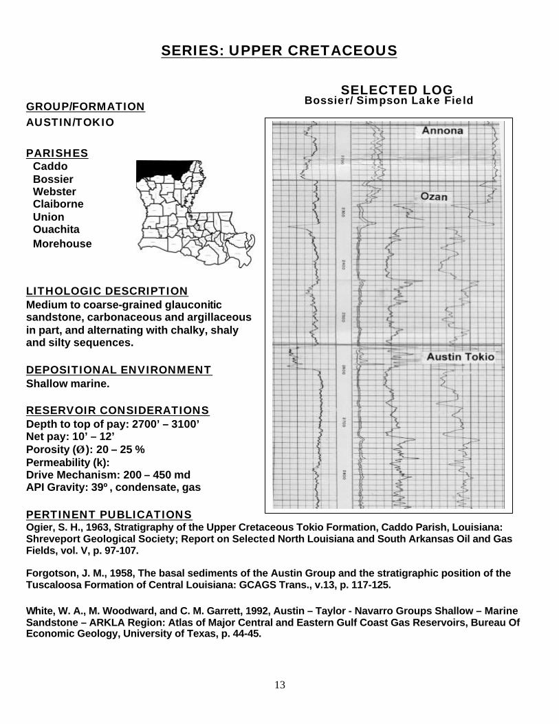
SELECTED LOG GROUP/FORMATION AUSTIN/TOKIO PARISHES
LITHOLOGIC DESCRIPTION Medium to coarse-grained glauconitic sandstone, carbonaceous and argillaceous in part, and alternating with chalky, shaly and silty sequences. DEPOSITIONAL ENVIRONMENT Shallow marine. RESERVOIR CONSIDERATIONS Depth to top of pay: 2700’ – 3100’ Net pay: 10’ – 12’ Porosity (ÂÂ ): 20 – 25 % Permeability (k): Drive Mechanism: 200 – 450 md API Gravity: 39º, condensate, gas PERTINENT PUBLICATIONS Ogier, S. H., 1963, Stratigraphy of the Upper Cretaceous Tokio Formation, Caddo Parish, Louisiana: Shreveport Geological Society; Report on Selected North Louisiana and South Arkansas Oil and Gas Fields, vol. V, p. 97-107. Forgotson, J. M., 1958, The basal sediments of the Austin Group and the stratigraphic position of the Tuscaloosa Formation of Central Louisiana: GCAGS Trans., v.13, p. 117-125. White, W. A., M. Woodward, and C. M. Garrett, 1992, Austin – Taylor - Navarro Groups Shallow – Marine Sandstone – ARKLA Region: Atlas of Major Central and Eastern Gulf Coast Gas Reservoirs, Bureau Of Economic Geology, University of Texas, p. 44-45.
Caddo Bossier Webster Claiborne Union Ouachita Morehouse
Bossier/ Simpson Lake Field
14
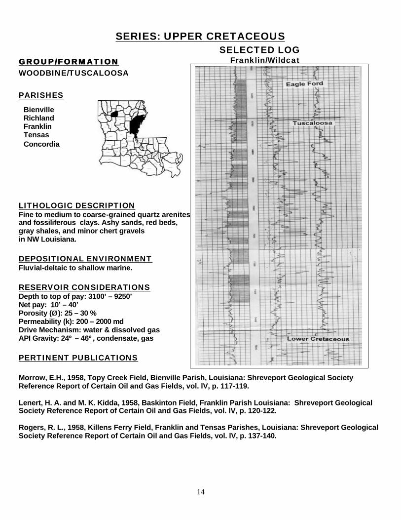
SERIES: UPPER CRETACEOUS SELECTED LOG GROUP/FORMATION GROUP/FORMATION WOODBINE/TUSCALOOSA PARISHES
LITHOLOGIC DESCRIPTION Fine to medium to coarse-grained quartz arenites and fossiliferous clays. Ashy sands, red beds, gray shales, and minor chert gravels in NW Louisiana. DEPOSITIONAL ENVIRONMENT Fluvial-deltaic to shallow marine. RESERVOIR CONSIDERATIONS Depth to top of pay: 3100’ – 9250’ Net pay: 10’ – 40’ Porosity (ÂÂ ): 25 – 30 % Permeability (k): 200 – 2000 md Drive Mechanism: water & dissolved gas API Gravity: 24º – 46º, condensate, gas PERTINENT PUBLICATIONS Morrow, E.H., 1958, Topy Creek Field, Bienville Parish, Louisiana: Shreveport Geological Society Reference Report of Certain Oil and Gas Fields, vol. lV, p. 117-119. Lenert, H. A. and M. K. Kidda, 1958, Baskinton Field, Franklin Parish Louisiana: Shreveport Geological Society Reference Report of Certain Oil and Gas Fields, vol. lV, p. 120-122. Rogers, R. L., 1958, Killens Ferry Field, Franklin and Tensas Parishes, Louisiana: Shreveport Geological Society Reference Report of Certain Oil and Gas Fields, vol. lV, p. 137-140.
Bienville Richland Franklin Tensas Concordia
Franklin/Wildcat
15
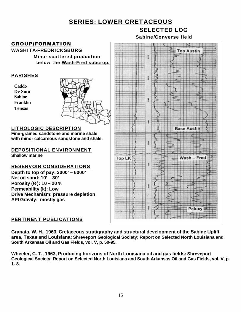
SERIES: LOWER CRETACEOUS SELECTED LOG
Sabine/Converse field GROUP/FORMATION GROUP/FORMATION WASHITA-FREDRICKSBURG Minor scattered production below the Wash-Fred subcrop. PARISHES
LITHOLOGIC DESCRIPTION Fine-grained sandstone and marine shale with minor calcareous sandstone and shale.
DEPOSITIONAL ENVIRONMENT Shallow marine
RESERVOIR CONSIDERATIONS Depth to top of pay: 3000’ – 6000’ Net oil sand: 10’ – 30’ Porosity (ÂÂ ): 10 – 20 % Permeability (k): Low Drive Mechanism: pressure depletion API Gravity: mostly gas PERTINENT PUBLICATIONS Granata, W. H., 1963, Cretaceous stratigraphy and structural development of the Sabine Uplift area, Texas and Louisiana: Shreveport Geological Society; Report on Selected North Louisiana and South Arkansas Oil and Gas Fields, vol. V, p. 50-95. Wheeler, C. T., 1963, Producing horizons of North Louisiana oil and gas fields: Shreveport Geological Society; Report on Selected North Louisiana and South Arkansas Oil and Gas Fields, vol. V, p. 1- 8.
Caddo De Soto Sabine Franklin Tensas
�
16
SERIES: LOWER CRETACESERIES: LOWER CRETACEOUSOUS
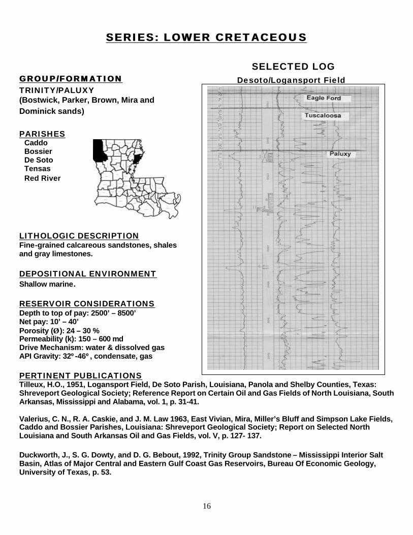
SELECTED LOG GROUP/FORMATION GROUP/FORMATION TRINITY/PALUXY (Bostwick, Parker, Brown, Mira and Dominick sands) PARISHES
LITHOLOGIC DESCRIPTION Fine-grained calcareous sandstones, shales and gray limestones. DEPOSITIONAL ENVIRONMENT Shallow marine. RESERVOIR CONSIDERATIONS Depth to top of pay: 2500’ – 8500’ Net pay: 10’ – 40’ Porosity (ÂÂ ): 24 – 30 % Permeability (k): 150 – 600 md Drive Mechanism: water & dissolved gas API Gravity: 32º-46º, condensate, gas
PERTINENT PUBLICATIONS Tilleux, H.O., 1951, Logansport Field, De Soto Parish, Louisiana, Panola and Shelby Counties, Texas: Shreveport Geological Society; Reference Report on Certain Oil and Gas Fields of North Louisiana, South Arkansas, Mississippi and Alabama, vol. 1, p. 31-41. Valerius, C. N., R. A. Caskie, and J. M. Law 1963, East Vivian, Mira, Miller’s Bluff and Simpson Lake Fields, Caddo and Bossier Parishes, Louisiana: Shreveport Geological Society; Report on Selected North Louisiana and South Arkansas Oil and Gas Fields, vol. V, p. 127- 137. Duckworth, J., S. G. Dowty, and D. G. Bebout, 1992, Trinity Group Sandstone – Mississippi Interior Salt Basin, Atlas of Major Central and Eastern Gulf Coast Gas Reservoirs, Bureau Of Economic Geology, University of Texas, p. 53.
Caddo Bossier De Soto Tensas Red River
Desoto/Logansport Field
17
SERIES: LOWER CRETACEOUS
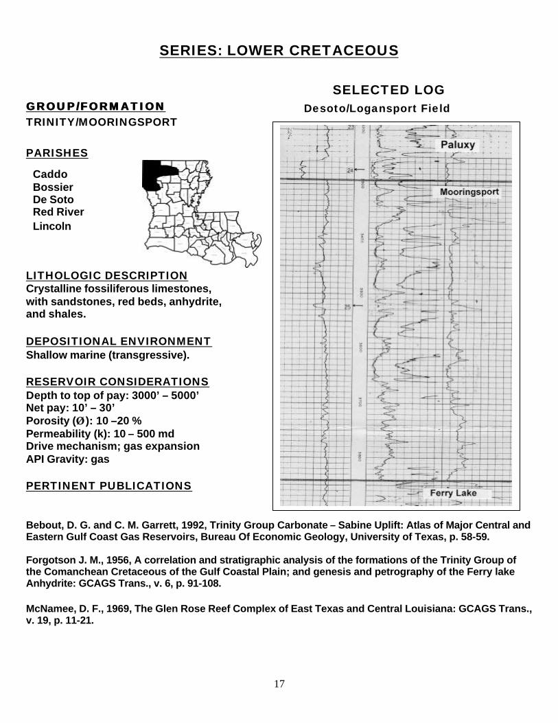
SELECTED LOG GROUP/FORMATION GROUP/FORMATION TRINITY/MOORINGSPORT PARISHES
LITHOLOGIC DESCRIPTION Crystalline fossiliferous limestones, with sandstones, red beds, anhydrite, and shales. DEPOSITIONAL ENVIRONMENT Shallow marine (transgressive). RESERVOIR CONSIDERATIONS Depth to top of pay: 3000’ – 5000’ Net pay: 10’ – 30’ Porosity (ÂÂ ): 10 –20 % Permeability (k): 10 – 500 md Drive mechanism; gas expansion API Gravity: gas PERTINENT PUBLICATIONS Bebout, D. G. and C. M. Garrett, 1992, Trinity Group Carbonate – Sabine Uplift: Atlas of Major Central and Eastern Gulf Coast Gas Reservoirs, Bureau Of Economic Geology, University of Texas, p. 58-59. Forgotson J. M., 1956, A correlation and stratigraphic analysis of the formations of the Trinity Group of the Comanchean Cretaceous of the Gulf Coastal Plain; and genesis and petrography of the Ferry lake Anhydrite: GCAGS Trans., v. 6, p. 91-108. McNamee, D. F., 1969, The Glen Rose Reef Complex of East Texas and Central Louisiana: GCAGS Trans., v. 19, p. 11-21.
Caddo Bossier De Soto Red River Lincoln
Desoto/Logansport Field
18
SERIES: LOWER CRETACEOUS SELECTED LOG
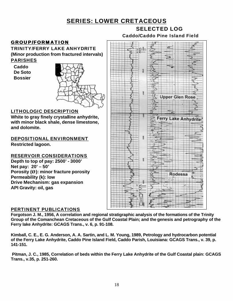
Caddo/Caddo Pine Island Field GROUP/FORMATION GROUP/FORMATION TRINITY/FERRY LAKE ANHYDRITE (Minor production from fractured intervals) PARISHES
LITHOLOGIC DESCRIPTION White to gray finely crystalline anhydrite, with minor black shale, dense limestone, and dolomite. DEPOSITIONAL ENVIRONMENT Restricted lagoon. RESERVOIR CONSIDERATIONS Depth to top of pay: 2500’ - 3000’ Net pay: 20’ – 50’ Porosity (ÂÂ ): minor fracture porosity Permeability (k): low Drive Mechanism: gas expansion API Gravity: oil, gas PERTINENT PUBLICATIONS Forgotson J. M., 1956, A correlation and regional stratigraphic analysis of the formations of the Trinity Group of the Comanchean Cretaceous of the Gulf Coastal Plain; and the genesis and petrography of the Ferry lake Anhydrite: GCAGS Trans., v. 6, p. 91-108. Kimball, C. E., E. G. Anderson, A. A. Sartin, and L. M. Young, 1989, Petrology and hydrocarbon potential of the Ferry Lake Anhydrite, Caddo Pine Island Field, Caddo Parish, Louisiana: GCAGS Trans., v. 39, p. 141-151. Pitman, J. C., 1985, Correlation of beds within the Ferry Lake Anhydrite of the Gulf Coastal plain: GCAGS Trans., v.35, p. 251-260.
Caddo De Soto Bossier
19
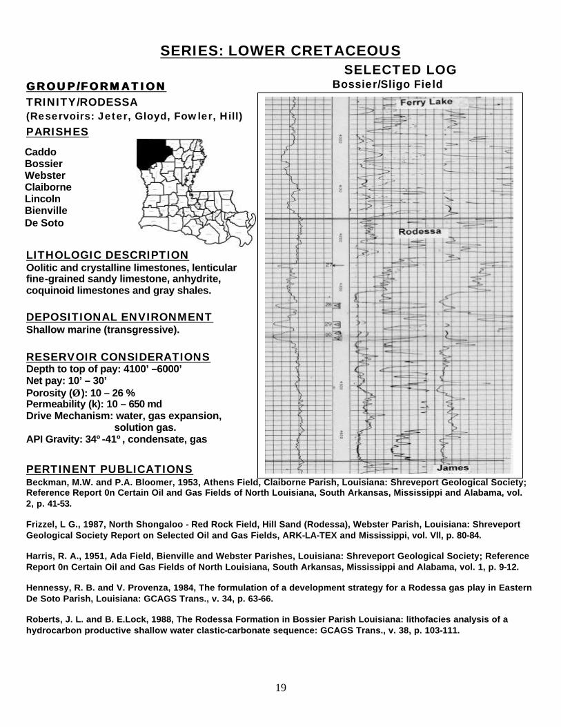
SERIES: LOWER CRETACEOUS SELECTED LOG
GROUP/FORMATION GROUP/FORMATION TRINITY/RODESSA (Reservoirs: Jeter, Gloyd, Fowler, Hill) PARISHES
LITHOLOGIC DESCRIPTION Oolitic and crystalline limestones, lenticular fine-grained sandy limestone, anhydrite, coquinoid limestones and gray shales.
DEPOSITIONAL ENVIRONMENT Shallow marine (transgressive). RESERVOIR CONSIDERATIONS Depth to top of pay: 4100’ –6000’ Net pay: 10’ – 30’ Porosity (ÂÂ ): 10 – 26 % Permeability (k): 10 – 650 md Drive Mechanism: water, gas expansion, solution gas. API Gravity: 34º-41º, condensate, gas PERTINENT PUBLICATIONS Beckman, M.W. and P.A. Bloomer, 1953, Athens Field, Claiborne Parish, Louisiana: Shreveport Geological Society; Reference Report 0n Certain Oil and Gas Fields of North Louisiana, South Arkansas, Mississippi and Alabama, vol. 2, p. 41-53. Frizzel, L G., 1987, North Shongaloo - Red Rock Field, Hill Sand (Rodessa), Webster Parish, Louisiana: Shreveport Geological Society Report on Selected Oil and Gas Fields, ARK-LA-TEX and Mississippi, vol. Vll, p. 80-84. Harris, R. A., 1951, Ada Field, Bienville and Webster Parishes, Louisiana: Shreveport Geological Society; Reference Report 0n Certain Oil and Gas Fields of North Louisiana, South Arkansas, Mississippi and Alabama, vol. 1, p. 9-12. Hennessy, R. B. and V. Provenza, 1984, The formulation of a development strategy for a Rodessa gas play in Eastern De Soto Parish, Louisiana: GCAGS Trans., v. 34, p. 63-66. Roberts, J. L. and B. E.Lock, 1988, The Rodessa Formation in Bossier Parish Louisiana: lithofacies analysis of a hydrocarbon productive shallow water clastic-carbonate sequence: GCAGS Trans., v. 38, p. 103-111.
Caddo Bossier Webster Claiborne Lincoln Bienville De Soto
Bossier/Sligo Field
20
SERIES: LOWER CRETACEOUS
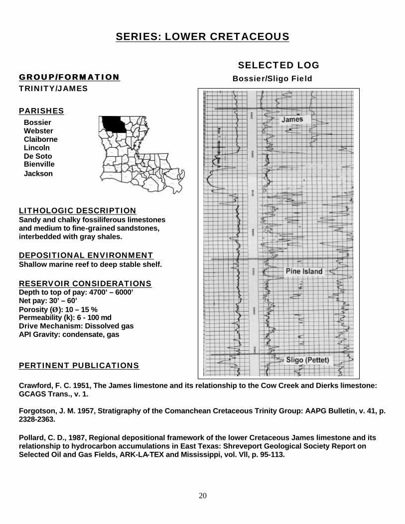
SELECTED LOG GROUP/FORMATION GROUP/FORMATION TRINITY/JAMES PARISHES
LITHOLOGIC DESCRIPTION Sandy and chalky fossiliferous limestones and medium to fine-grained sandstones, interbedded with gray shales. DEPOSITIONAL ENVIRONMENT Shallow marine reef to deep stable shelf. RESERVOIR CONSIDERATIONS Depth to top of pay: 4700’ – 6000’ Net pay: 30’ – 60’ Porosity (ÂÂ ): 10 – 15 % Permeability (k): 6 - 100 md Drive Mechanism: Dissolved gas API Gravity: condensate, gas PERTINENT PUBLICATIONS Crawford, F. C. 1951, The James limestone and its relationship to the Cow Creek and Dierks limestone: GCAGS Trans., v. 1. Forgotson, J. M. 1957, Stratigraphy of the Comanchean Cretaceous Trinity Group: AAPG Bulletin, v. 41, p. 2328-2363. Pollard, C. D., 1987, Regional depositional framework of the lower Cretaceous James limestone and its relationship to hydrocarbon accumulations in East Texas: Shreveport Geological Society Report on Selected Oil and Gas Fields, ARK-LA-TEX and Mississippi, vol. Vll, p. 95-113.
Bossier Webster Claiborne Lincoln De Soto Bienville Jackson
Bossier/Sligo Field
21
SERIES: LOWER CRETACEOUS SELECTED LOG
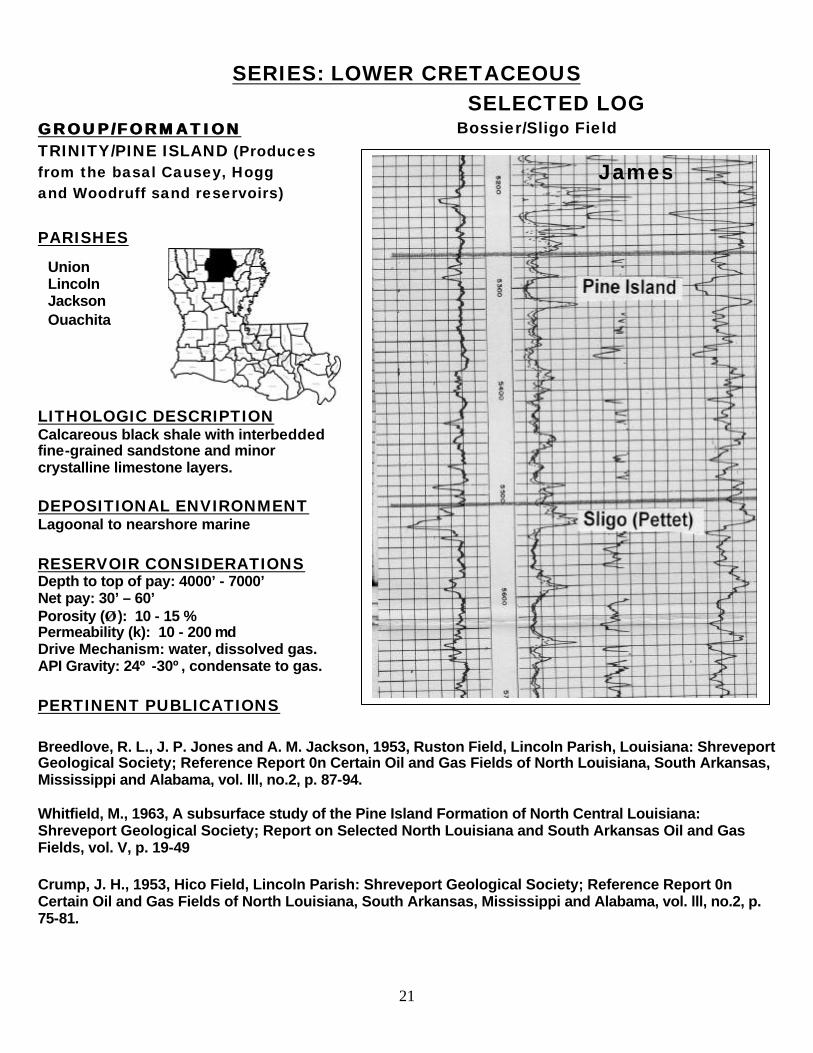
GROUP/FORMATION GROUP/FORMATION TRINITY/PINE ISLAND (Produces from the basal Causey, Hogg and Woodruff sand reservoirs) PARISHES
LITHOLOGIC DESCRIPTION Calcareous black shale with interbedded fine-grained sandstone and minor crystalline limestone layers.
DEPOSITIONAL ENVIRONMENT Lagoonal to nearshore marine RESERVOIR CONSIDERATIONS Depth to top of pay: 4000’ - 7000’ Net pay: 30’ – 60’ Porosity (ÂÂ ): 10 - 15 % Permeability (k): 10 - 200 md Drive Mechanism: water, dissolved gas. API Gravity: 24º -30º, condensate to gas. PERTINENT PUBLICATIONS Breedlove, R. L., J. P. Jones and A. M. Jackson, 1953, Ruston Field, Lincoln Parish, Louisiana: Shreveport Geological Society; Reference Report 0n Certain Oil and Gas Fields of North Louisiana, South Arkansas, Mississippi and Alabama, vol. lll, no.2, p. 87-94. Whitfield, M., 1963, A subsurface study of the Pine Island Formation of North Central Louisiana: Shreveport Geological Society; Report on Selected North Louisiana and South Arkansas Oil and Gas Fields, vol. V, p. 19-49 Crump, J. H., 1953, Hico Field, Lincoln Parish: Shreveport Geological Society; Reference Report 0n Certain Oil and Gas Fields of North Louisiana, South Arkansas, Mississippi and Alabama, vol. lll, no.2, p. 75-81.
Union Lincoln Jackson Ouachita
James
Bossier/Sligo Field
22
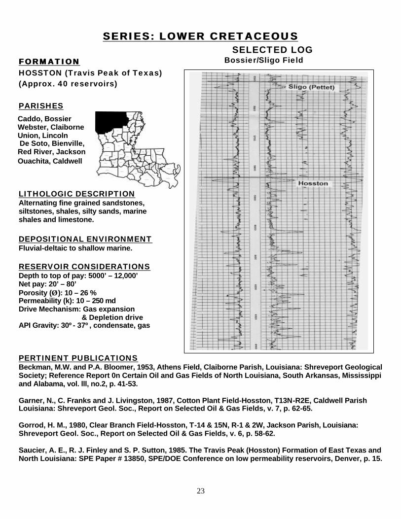
SERIES: LOWER CRETACEOUS SELECTED LOG
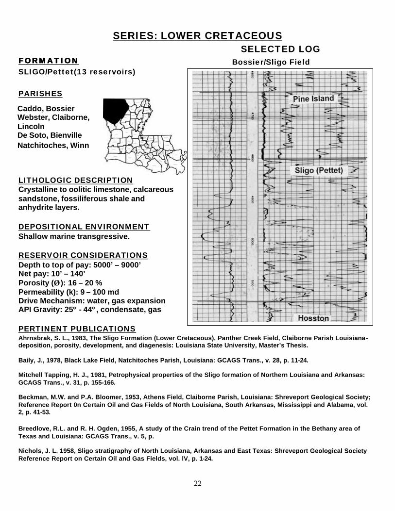
FORMATION FORMATION SLIGO/Pettet(13 reservoirs) PARISHES
LITHOLOGIC DESCRIPTION Crystalline to oolitic limestone, calcareous sandstone, fossiliferous shale and anhydrite layers. DEPOSITIONAL ENVIRONMENT Shallow marine transgressive. RESERVOIR CONSIDERATIONS Depth to top of pay: 5000’ – 9000’ Net pay: 10’ – 140’ Porosity (ÂÂ ): 16 – 20 % Permeability (k): 9 – 100 md Drive Mechanism: water, gas expansion API Gravity: 25º - 44º, condensate, gas PERTINENT PUBLICATIONS Ahrnsbrak, S. L., 1983, The Sligo Formation (Lower Cretaceous), Panther Creek Field, Claiborne Parish Louisiana- deposition, porosity, development, and diagenesis: Louisiana State University, Master’s Thesis. Baily, J., 1978, Black Lake Field, Natchitoches Parish, Louisiana: GCAGS Trans., v. 28, p. 11-24. Mitchell Tapping, H. J., 1981, Petrophysical properties of the Sligo formation of Northern Louisiana and Arkansas: GCAGS Trans., v. 31, p. 155-166. Beckman, M.W. and P.A. Bloomer, 1953, Athens Field, Claiborne Parish, Louisiana: Shreveport Geological Society; Reference Report 0n Certain Oil and Gas Fields of North Louisiana, South Arkansas, Mississippi and Alabama, vol. 2, p. 41-53. Breedlove, R.L. and R. H. Ogden, 1955, A study of the Crain trend of the Pettet Formation in the Bethany area of Texas and Louisiana: GCAGS Trans., v. 5, p. Nichols, J. L. 1958, Sligo stratigraphy of North Louisiana, Arkansas and East Texas: Shreveport Geological Society Reference Report on Certain Oil and Gas Fields, vol. lV, p. 1-24.
Caddo, Bossier Webster, Claiborne, Lincoln De Soto, Bienville Natchitoches, Winn
Bossier/Sligo Field
23
SERIES: LOWER CRETACEOUSSERIES: LOWER CRETACEOUS SELECTED LOG
FORMATION FORMATION HOSSTON (Travis Peak of Texas) (Approx. 40 reservoirs) PARISHES
LITHOLOGIC DESCRIPTION Alternating fine grained sandstones, siltstones, shales, silty sands, marine shales and limestone. DEPOSITIONAL ENVIRONMENT Fluvial-deltaic to shallow marine. RESERVOIR CONSIDERATIONS Depth to top of pay: 5000’ – 12,000’ Net pay: 20’ – 80’ Porosity (ÂÂ ): 10 – 26 % Permeability (k): 10 – 250 md Drive Mechanism: Gas expansion & Depletion drive API Gravity: 30º- 37º, condensate, gas
PERTINENT PUBLICATIONS Beckman, M.W. and P.A. Bloomer, 1953, Athens Field, Claiborne Parish, Louisiana: Shreveport Geological Society; Reference Report 0n Certain Oil and Gas Fields of North Louisiana, South Arkansas, Mississippi and Alabama, vol. lll, no.2, p. 41-53. Garner, N., C. Franks and J. Livingston, 1987, Cotton Plant Field-Hosston, T13N-R2E, Caldwell Parish Louisiana: Shreveport Geol. Soc., Report on Selected Oil & Gas Fields, v. 7, p. 62-65. Gorrod, H. M., 1980, Clear Branch Field-Hosston, T-14 & 15N, R-1 & 2W, Jackson Parish, Louisiana: Shreveport Geol. Soc., Report on Selected Oil & Gas Fields, v. 6, p. 58-62. Saucier, A. E., R. J. Finley and S. P. Sutton, 1985. The Travis Peak (Hosston) Formation of East Texas and North Louisiana: SPE Paper # 13850, SPE/DOE Conference on low permeability reservoirs, Denver, p. 15.
Caddo, Bossier Webster, Claiborne Union, Lincoln De Soto, Bienville, Red River, Jackson Ouachita, Caldwell
Bossier/Sligo Field
24
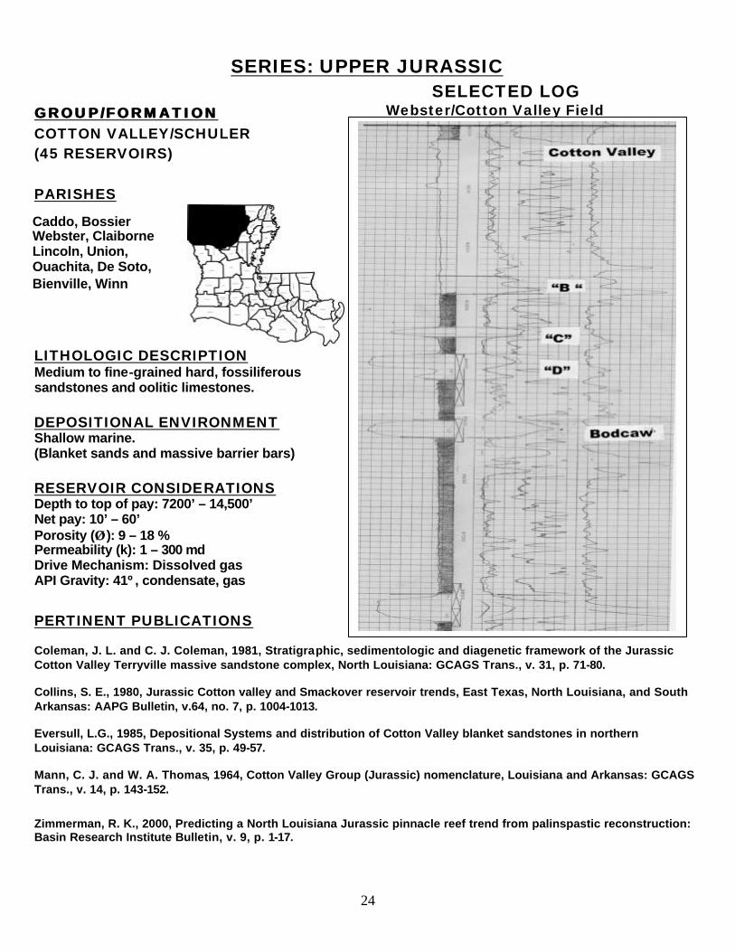
SERIES: UPPER JURASSIC SELECTED LOG
GROUP/FORMATION GROUP/FORMATION COTTON VALLEY/SCHULER (45 RESERVOIRS) PARISHES
LITHOLOGIC DESCRIPTION Medium to fine-grained hard, fossiliferous sandstones and oolitic limestones.
DEPOSITIONAL ENVIRONMENT Shallow marine. (Blanket sands and massive barrier bars)
RESERVOIR CONSIDERATIONS Depth to top of pay: 7200’ – 14,500’ Net pay: 10’ – 60’ Porosity (ÂÂ ): 9 – 18 % Permeability (k): 1 – 300 md Drive Mechanism: Dissolved gas API Gravity: 41º, condensate, gas
PERTINENT PUBLICATIONS Coleman, J. L. and C. J. Coleman, 1981, Stratigraphic, sedimentologic and diagenetic framework of the Jurassic Cotton Valley Terryville massive sandstone complex, North Louisiana: GCAGS Trans., v. 31, p. 71-80. Collins, S. E., 1980, Jurassic Cotton valley and Smackover reservoir trends, East Texas, North Louisiana, and South Arkansas: AAPG Bulletin, v.64, no. 7, p. 1004-1013. Eversull, L.G., 1985, Depositional Systems and distribution of Cotton Valley blanket sandstones in northern Louisiana: GCAGS Trans., v. 35, p. 49-57. Mann, C. J. and W. A. Thomas, 1964, Cotton Valley Group (Jurassic) nomenclature, Louisiana and Arkansas: GCAGS Trans., v. 14, p. 143-152. Zimmerman, R. K., 2000, Predicting a North Louisiana Jurassic pinnacle reef trend from palinspastic reconstruction: Basin Research Institute Bulletin, v. 9, p. 1-17.
Caddo, Bossier Webster, Claiborne Lincoln, Union, Ouachita, De Soto, Bienville, Winn
Webster/Cotton Valley Field
25
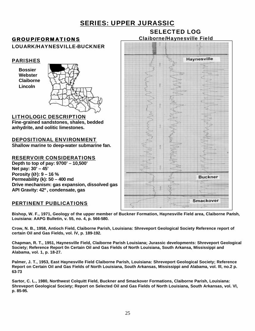
SERIES: UPPER JURASSIC SELECTED LOG
GROUP/FORMATIONS GROUP/FORMATIONS LOUARK/HAYNESVILLE-BUCKNER PARISHES
LITHOLOGIC DESCRIPTION Fine-grained sandstones, shales, bedded anhydrite, and oolitic limestones. DEPOSITIONAL ENVIRONMENT Shallow marine to deep-water submarine fan. RESERVOIR CONSIDERATIONS Depth to top of pay: 9700’ – 10,500’ Net pay: 30’ – 45’ Porosity (ÂÂ ): 9 – 16 % Permeability (k): 50 – 400 md Drive mechanism: gas expansion, dissolved gas API Gravity: 42º, condensate, gas PERTINENT PUBLICATIONS Bishop, W. F., 1971, Geology of the upper member of Buckner Formation, Haynesville Field area, Claiborne Parish, Louisiana: AAPG Bulletin, v. 55, no. 4, p. 566-580. Crow, N. B., 1958, Antioch Field, Claiborne Parish, Louisiana: Shreveport Geological Society Reference report of certain Oil and Gas Fields, vol. lV, p. 189-192. Chapman, R. T., 1951, Haynesville Field, Claiborne Parish Louisiana; Jurassic developments: Shreveport Geological Society; Reference Report 0n Certain Oil and Gas Fields of North Louisiana, South Arkansa, Mississippi and Alabama, vol. 1, p. 18-27. Palmer, J. T., 1953, East Haynesville Field Claiborne Parish, Louisiana: Shreveport Geological Society; Reference Report on Certain Oil and Gas Fields of North Louisiana, South Arkansas, Mississippi and Alabama, vol. lll, no.2 p. 63-73 Sartor, C. L., 1980, Northwest Colquitt Field, Buckner and Smackover Formations, Claiborne Parish, Louisiana: Shreveport Geological Society; Report on Selected Oil and Gas Fields of North Louisiana, South Arkansas, vol. Vl, p. 85-95.
Bossier Webster Claiborne Lincoln
Claiborne/Haynesville Field
26
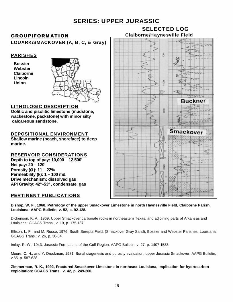
SERIES: UPPER JURASSIC SELECTED LOG
GROUP/FORMATION GROUP/FORMATION LOUARK/SMACKOVER (A, B, C, & Gray) PARISHES
LITHOLOGIC DESCRIPTION Oolitic and pisolitic limestone (mudstone, wackestone, packstone) with minor silty calcareous sandstone.
DEPOSITIONAL ENVIRONMENT Shallow marine (beach, shoreface) to deep marine.
RESERVOIR CONSIDERATIONS Depth to top of pay: 10,000 – 12,500’ Net pay: 20 – 120’ Porosity (ÂÂ ): 11 – 22% Permeability (k): 1 – 100 md. Drive mechanism: dissolved gas API Gravity: 42º-53º, condensate, gas PERTINENT PUBLICATIONS Bishop, W. F., 1968, Petrology of the upper Smackover Limestone in north Haynesville Field, Claiborne Parish, Louisiana: AAPG Bulletin, v. 52, p. 92-128. Dickenson, K. A., 1969, Upper Smackover carbonate rocks in northeastern Texas, and adjoining parts of Arkansas and Louisiana: GCAGS Trans., v. 19, p. 175-187. Ellison, L. F., and M. Russo, 1976, South Serepta Field, (Smackover Gray Sand), Bossier and Webster Parishes, Louisiana: GCAGS Trans.: v. 26, p. 30-34. Imlay, R. W., 1943, Jurassic Formations of the Gulf Region: AAPG Bulletin, v. 27, p. 1407-1533. Moore, C. H., and Y. Druckman, 1981, Burial diagenesis and porosity evaluation, upper Jurassic Smackover: AAPG Bulletin, v.65, p. 587-628. Zimmerman, R. K., 1992, Fractured Smackover Limestone in northeast Louisiana, implication for hydrocarbon exploitation: GCAGS Trans., v. 42, p. 249-260.
Bossier Webster Claiborne Lincoln Union
Claiborne/Haynesville Field
27
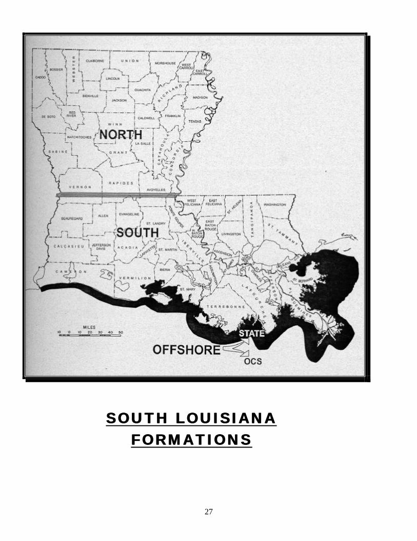
SOSOUTH LOUISIANA UTH LOUISIANA FORMATIONSFORMATIONS
ENVIRONENVIRON
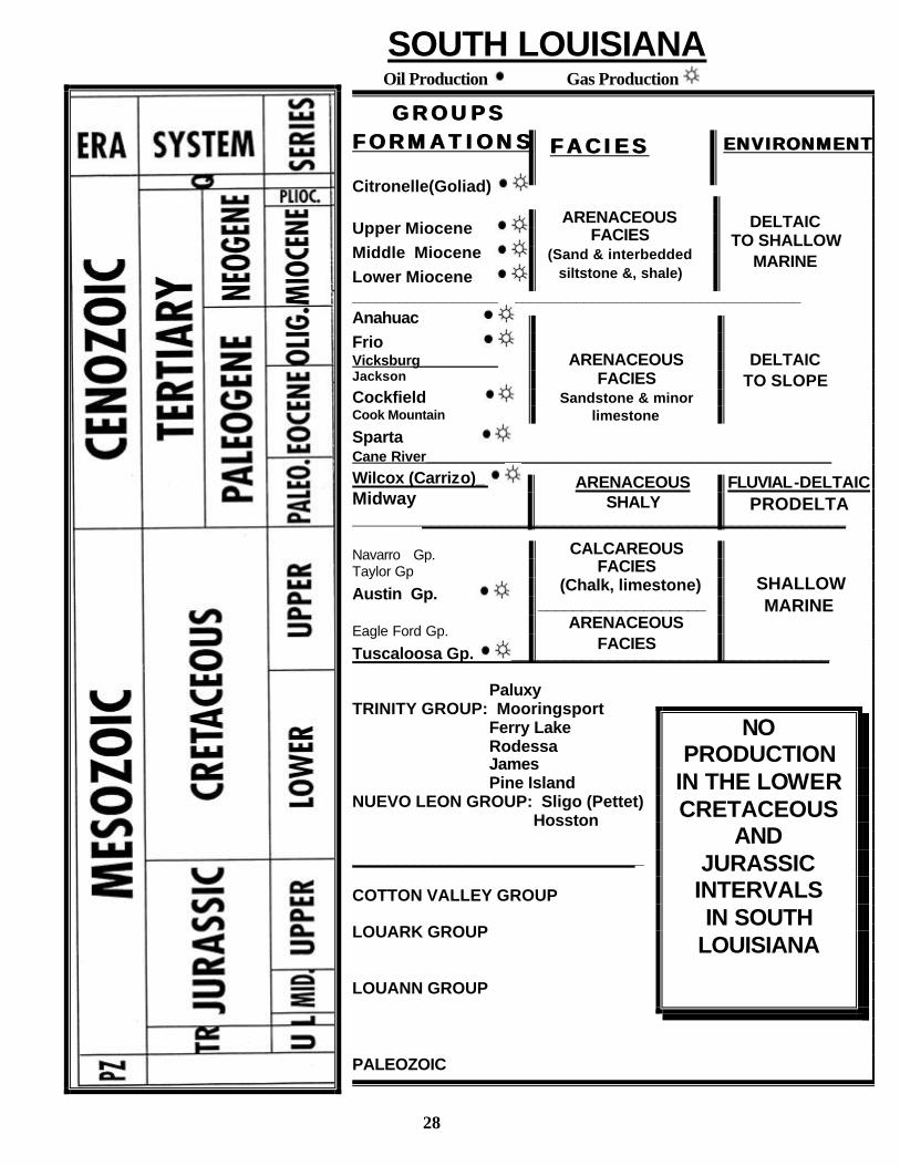
GROUPSGROUPS FORMATIONSFORMATIONS
Citronelle(Goliad) Upper Miocene
Middle Miocene
Lower Miocene __________________________________________________________
Anahuac
Frio Vicksburg__________ Jackson
Cockfield Cook Mountain
Sparta Cane River____________________________________________________
Wilcox (Carrizo)_ Midway _______________________________________________________ Navarro Gp. Taylor Gp
Austin Gp. Eagle Ford Gp.
Tuscaloosa Gp. ____________________________________ Paluxy TRINITY GROUP: Mooringsport Ferry Lake Rodessa James Pine Island NUEVO LEON GROUP: Sligo (Pettet) Hosston _________________________________ COTTON VALLEY GROUP LOUARK GROUP LOUANN GROUP PALEOZOIC
SOUTH LOUISIANA Oil Production Gas Production
CALCAREOUS FACIES
(Chalk, limestone) ___________________
ARENACEOUS FACIES
ARENACEOUS SHALY
ARENACEOUS FACIES
(Sand & interbedded siltstone &, shale)
DELTAIC
TO SHALLOW MARINE
FACIESFACIES ENVIRONMENTENVIRONMENT
FLUVIAL-DELTAIC PRODELTA
NO PRODUCTION
IN THE LOWER CRETACEOUS
AND JURASSIC
INTERVALS IN SOUTH
LOUISIANA
SHALLOW
MARINE
ARENACEOUS FACIES
Sandstone & minor limestone
DELTAIC TO SLOPE
28
29
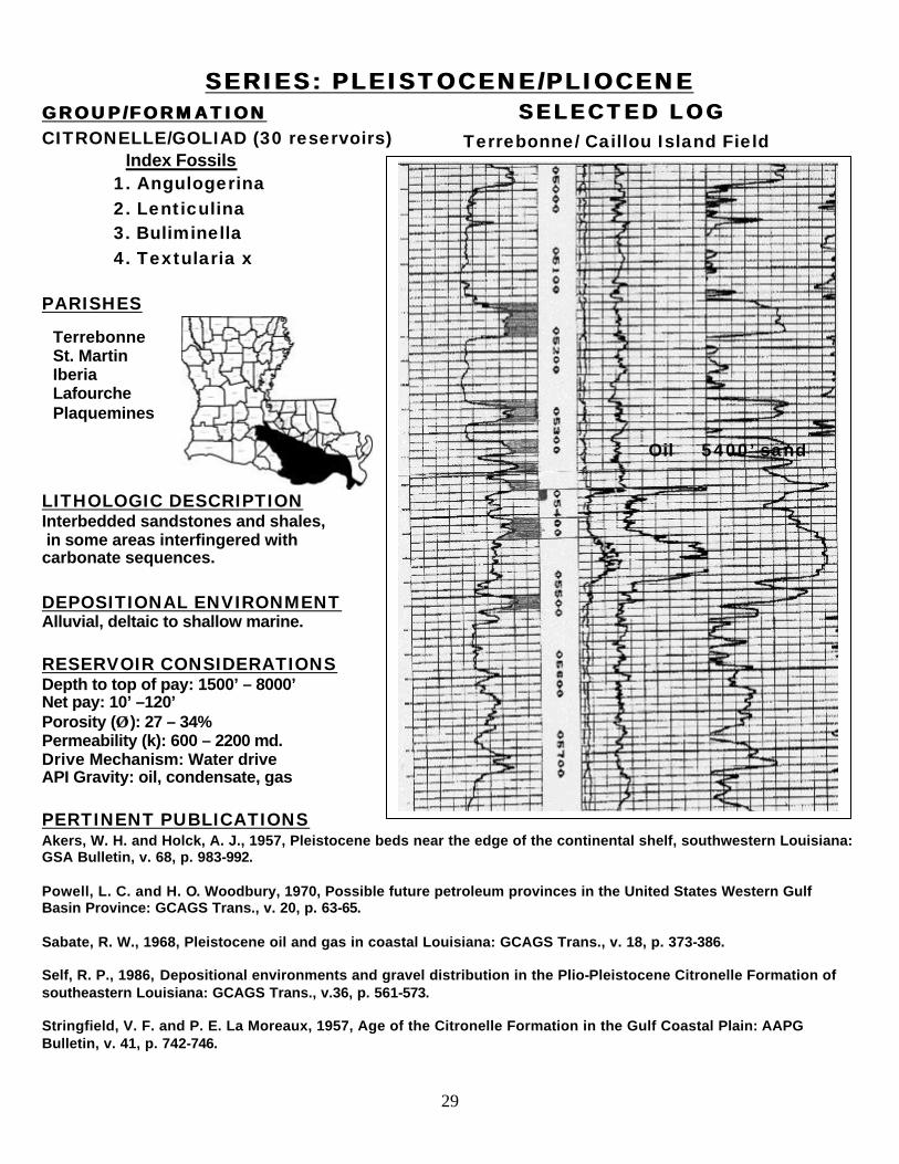
SERIES: PLEISTOCENE/PLIOCENESERIES: PLEISTOCENE/PLIOCENE GROUP/FORMATIONGROUP/FORMATION SELECTED LOGSELECTED LOG CITRONELLE/GOLIAD (30 reservoirs) Index Fossils 1. Angulogerina 2. Lenticulina 3. Buliminella 4. Textularia x PARISHES
LITHOLOGIC DESCRIPTION Interbedded sandstones and shales, in some areas interfingered with carbonate sequences. DEPOSITIONAL ENVIRONMENT Alluvial, deltaic to shallow marine.
RESERVOIR CONSIDERATIONS Depth to top of pay: 1500’ – 8000’ Net pay: 10’ –120’ Porosity (ÂÂ ): 27 – 34% Permeability (k): 600 – 2200 md. Drive Mechanism: Water drive API Gravity: oil, condensate, gas PERTINENT PUBLICATIONS Akers, W. H. and Holck, A. J., 1957, Pleistocene beds near the edge of the continental shelf, southwestern Louisiana: GSA Bulletin, v. 68, p. 983-992. Powell, L. C. and H. O. Woodbury, 1970, Possible future petroleum provinces in the United States Western Gulf Basin Province: GCAGS Trans., v. 20, p. 63-65. Sabate, R. W., 1968, Pleistocene oil and gas in coastal Louisiana: GCAGS Trans., v. 18, p. 373-386. Self, R. P., 1986, Depositional environments and gravel distribution in the Plio-Pleistocene Citronelle Formation of southeastern Louisiana: GCAGS Trans., v.36, p. 561-573. Stringfield, V. F. and P. E. La Moreaux, 1957, Age of the Citronelle Formation in the Gulf Coastal Plain: AAPG Bulletin, v. 41, p. 742-746.
Terrebonne St. Martin Iberia Lafourche Plaquemines
Oil 5400’ sand
Terrebonne/ Caillou Island Field
30
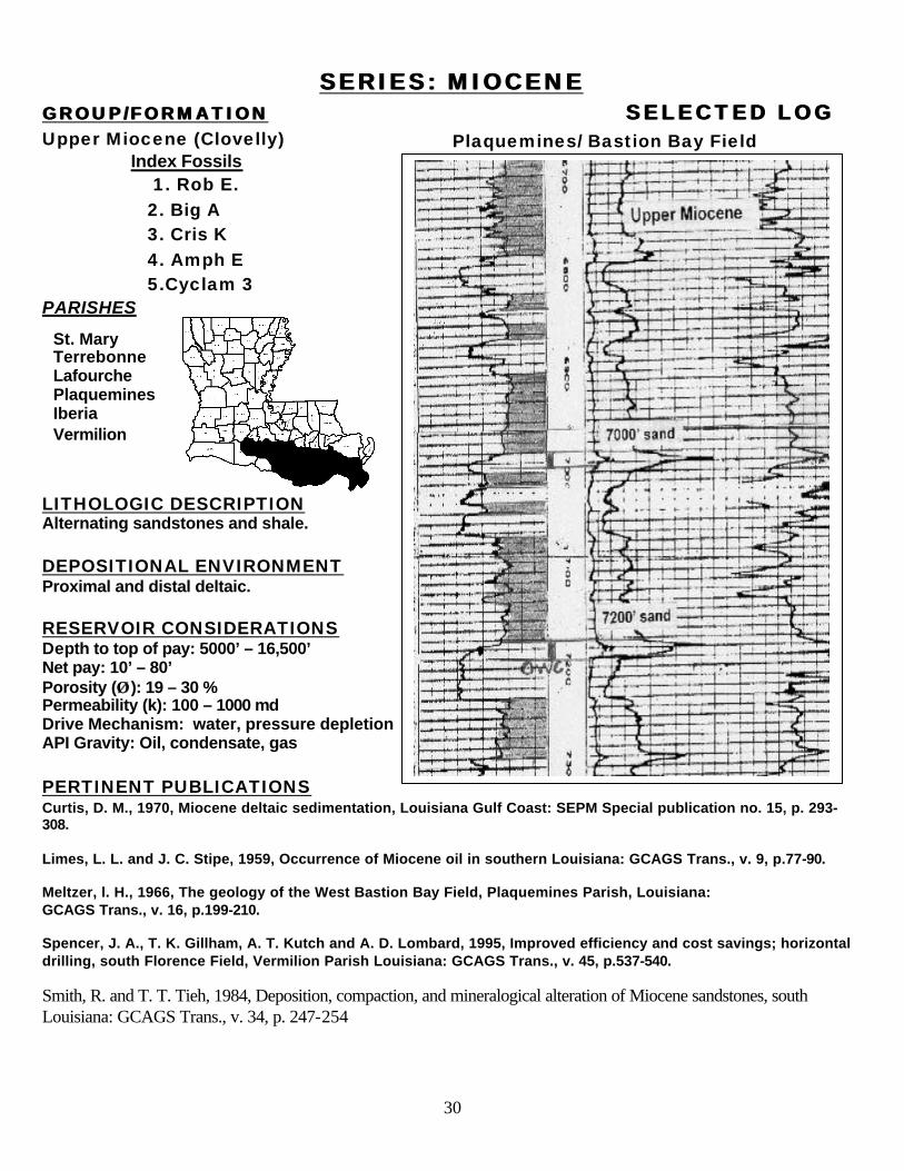
SERIES: MIOCENESERIES: MIOCENE GROUP/FORMATIONGROUP/FORMATION SELECTED LOGSELECTED LOG Upper Miocene (Clovelly) Index Fossils 1. Rob E. 2. Big A 3. Cris K 4. Amph E 5.Cyclam 3 PARISHES
LITHOLOGIC DESCRIPTION Alternating sandstones and shale. DEPOSITIONAL ENVIRONMENT Proximal and distal deltaic. RESERVOIR CONSIDERATIONS Depth to top of pay: 5000’ – 16,500’ Net pay: 10’ – 80’ Porosity (ÂÂ ): 19 – 30 % Permeability (k): 100 – 1000 md Drive Mechanism: water, pressure depletion API Gravity: Oil, condensate, gas PERTINENT PUBLICATIONS Curtis, D. M., 1970, Miocene deltaic sedimentation, Louisiana Gulf Coast: SEPM Special publication no. 15, p. 293-308. Limes, L. L. and J. C. Stipe, 1959, Occurrence of Miocene oil in southern Louisiana: GCAGS Trans., v. 9, p.77-90. Meltzer, l. H., 1966, The geology of the West Bastion Bay Field, Plaquemines Parish, Louisiana: GCAGS Trans., v. 16, p.199-210. Spencer, J. A., T. K. Gillham, A. T. Kutch and A. D. Lombard, 1995, Improved efficiency and cost savings; horizontal drilling, south Florence Field, Vermilion Parish Louisiana: GCAGS Trans., v. 45, p.537-540. Smith, R. and T. T. Tieh, 1984, Deposition, compaction, and mineralogical alteration of Miocene sandstones, south Louisiana: GCAGS Trans., v. 34, p. 247-254
St. Mary Terrebonne Lafourche Plaquemines Iberia Vermilion
Plaquemines/ Bastion Bay Field
31
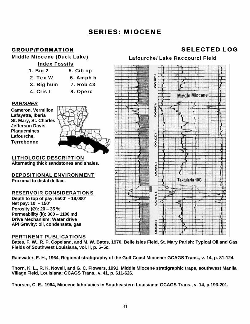
SERIES: MIOCENESERIES: MIOCENE
GROUP/FORMATIONGROUP/FORMATION SELECTED LOGSELECTED LOG Middle Miocene (Duck Lake) Index Fossils 1. Big 2 5. Cib op 2. Tex W 6. Amph b 3. Big hum 7. Rob 43 4. Cris I 8. Operc PARISHES
LITHOLOGIC DESCRIPTION Alternating thick sandstones and shales. DEPOSITIONAL ENVIRONMENT Proximal to distal deltaic. RESERVOIR CONSIDERATIONS Depth to top of pay: 6500’ – 18,000’ Net pay: 10’ – 150’ Porosity (ÂÂ ): 20 – 35 % Permeability (k): 300 – 1100 md Drive Mechanism: Water drive API Gravity: oil, condensate, gas PERTINENT PUBLICATIONS Bates, F. W., R. P. Copeland, and M. W. Bates, 1970, Belle Isles Field, St. Mary Parish: Typical Oil and Gas Fields of Southwest Louisiana, vol. ll, p. 5–5c. Rainwater, E. H., 1964, Regional stratigraphy of the Gulf Coast Miocene: GCAGS Trans., v. 14, p. 81-124. Thorn, K. L., R. K. Novell, and G. C. Flowers, 1991, Middle Miocene stratigraphic traps, southwest Manila Village Field, Louisiana: GCAGS Trans., v. 41, p. 611-626. Thorsen, C. E., 1964, Miocene lithofacies in Southeastern Louisiana: GCAGS Trans., v. 14, p.193-201.
Cameron, Vermilion Lafayette, Iberia St. Mary, St. Charles Jefferson Davis Plaquemines Lafourche, Terrebonne
Lafourche/ Lake Raccourci Field
32
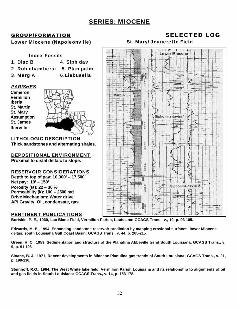
SERIES: MIOCENE GROUP/FORMATIONGROUP/FORMATION SELECTED LOGSELECTED LOG Lower Miocene (Napoleonville) Index Fossils 1. Disc B 4. Siph dav 2. Rob chambersi 5. Plan palm 3. Marg A 6.Liebusella PARISHES
LITHOLOGIC DESCRIPTION Thick sandstones and alternating shales. DEPOSITIONAL ENVIRONMENT Proximal to distal deltaic to slope. RESERVOIR CONSIDERATIONS Depth to top of pay: 10,000’ – 17,500’ Net pay: 10’ – 150’ Porosity (ÂÂ ): 22 – 30 % Permeability (k): 100 – 2500 md Drive Mechanism: Water drive API Gravity: Oil, condensate, gas PERTINENT PUBLICATIONS Boriskie, P. E., 1960, Lac Blanc Field, Vermilion Parish, Louisiana: GCAGS Trans., v., 10, p. 93-105. Edwards, M. B., 1994, Enhancing sandstone reservoir prediction by mapping erosional surfaces, lower Miocene deltas, south Louisiana Gulf Coast Basin: GCAGS Trans., v. 44, p. 205-215. Green, H. C., 1959, Sedimentation and structure of the Planulina Abbeville trend South Louisiana, GCAGS Trans., v. 9, p. 91-103. Sloane, B. J., 1971, Recent developments in Miocene Planulina gas trends of South Louisiana: GCAGS Trans., v. 21, p. 199-210. Steinhoff, R.O., 1964, The West White lake field, Vermilion Parish Louisiana and its relationship to alignments of oil and gas fields in South Louisiana: GCAGS Trans., v. 14, p. 153-178.
Cameron Vermilion Iberia St. Martin St. Mary Assumption St. James Iberville
St. Mary/ Jeanerette Field
33
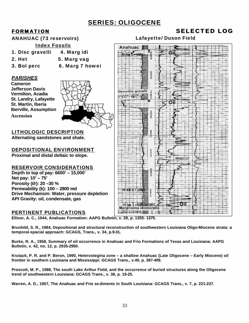
SERIES: OLIGOCENE FORMATIONFORMATION SELECTED LOGSELECTED LOG ANAHUAC (73 reservoirs) Index Fossils 1. Disc gravelli 4. Marg idi 2. Het 5. Marg vag 3. Bol perc 6. Marg 7 howei PARISHES
LITHOLOGIC DESCRIPTION Alternating sandstones and shale. DEPOSITIONAL ENVIRONMENT Proximal and distal deltaic to slope. RESERVOIR CONSIDERATIONS Depth to top of pay: 6600’ – 15,000’ Net pay: 10’ – 75’ Porosity (ÂÂ ): 20 –30 % Permeability (k): 100 – 2800 md Drive Mechanism: Water, pressure depletion API Gravity: oil, condensate, gas
PERTINENT PUBLICATIONS Ellisor, A. C., 1944, Anahuac Formation: AAPG Bulletin, v. 28, p. 1355- 1375. Brunhild, S. R., 1984, Depositional and structural reconstruction of southwestern Louisiana Oligo-Miocene strata: a temporal-spacial approach: GCAGS, Trans., v. 34, p.9-31. Burke, R. A., 1958, Summary of oil occurrence in Anahuac and Frio Formations of Texas and Louisiana: AAPG Bulletin, v. 42, no. 12, p. 2935-2950. Krutack, P. R. and P. Beron, 1990, Heterostegina zone – a shallow Anahuac (Late Oligocene – Early Miocene) oil frontier in southern Louisiana and Mississippi: GCAGS Trans., v.40, p. 397-409. Prescott, M. P., 1988, The south Lake Arthur Field, and the occurrence of buried structures along the Oligocene trend of southwestern Louisiana: GCAGS Trans., v. 38, p. 19-25. Warren, A. D., 1957, The Anahuac and Frio se diments in South Louisiana: GCAGS Trans., v. 7, p. 221-237.
Oil
Oil
Oil
Lafayette/ Duson Field
Cameron Jefferson Davis Vermilion, Acadia St. Landry, Lafayette St. Martin, Iberia Iberville, Assumption Ascension
34
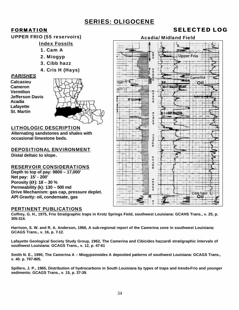
SERIES: OLIGOCENE FORMATIONFORMATION SELECTED LOGSELECTED LOG UPPER FRIO (55 reservoirs) Index Fossils 1. Cam A 2. Miogyp 3. Cibb hazz 4. Cris H (Hays) PARISHES
LITHOLOGIC DESCRIPTION Alternating sandstones and shales with occasional limestone beds.
DEPOSITIONAL ENVIRONMENT Distal deltaic to slope. RESERVOIR CONSIDERATIONS Depth to top of pay: 9800 – 17,000’ Net pay: 15’ - 200’ Porosity (ÂÂ ): 18 – 30 % Permeability (k): 130 – 500 md Drive Mechanism: gas cap, pressure deplet. API Gravity: oil, condensate, gas PERTINENT PUBLICATIONS Coffrey, G. H., 1975, Frio Stratigraphic traps in Krotz Springs Field, southwest Louisiana: GCAHS Trans., v. 25, p. 305-314. Harrison, S. W. and R. A. Anderson, 1966, A sub-regional report of the Camerina zone in southwest Louisiana: GCAGS Trans., v. 16, p. 7-12. Lafayette Geological Society Study Group, 1962, The Camerina and Cibicides hazzardi stratigraphic intervals of southwest Louisiana: GCAGS Trans., v. 12, p. 47-61 Smith N. E., 1990, The Camerina A – Miogypsinoides A deposited patterns of southwest Louisiana: GCAGS Trans., v. 40. p. 797-805. Spillers, J. P., 1965, Distribution of hydrocarbons in South Louisiana by types of traps and trends-Frio and younger sediments: GCAGS Trans., v. 15, p. 37-39.
Calcasieu Cameron Vermilion Jefferson Davis Acadia Lafayette St. Martin
Oil
Oil
Acadia/ Midland Field
35
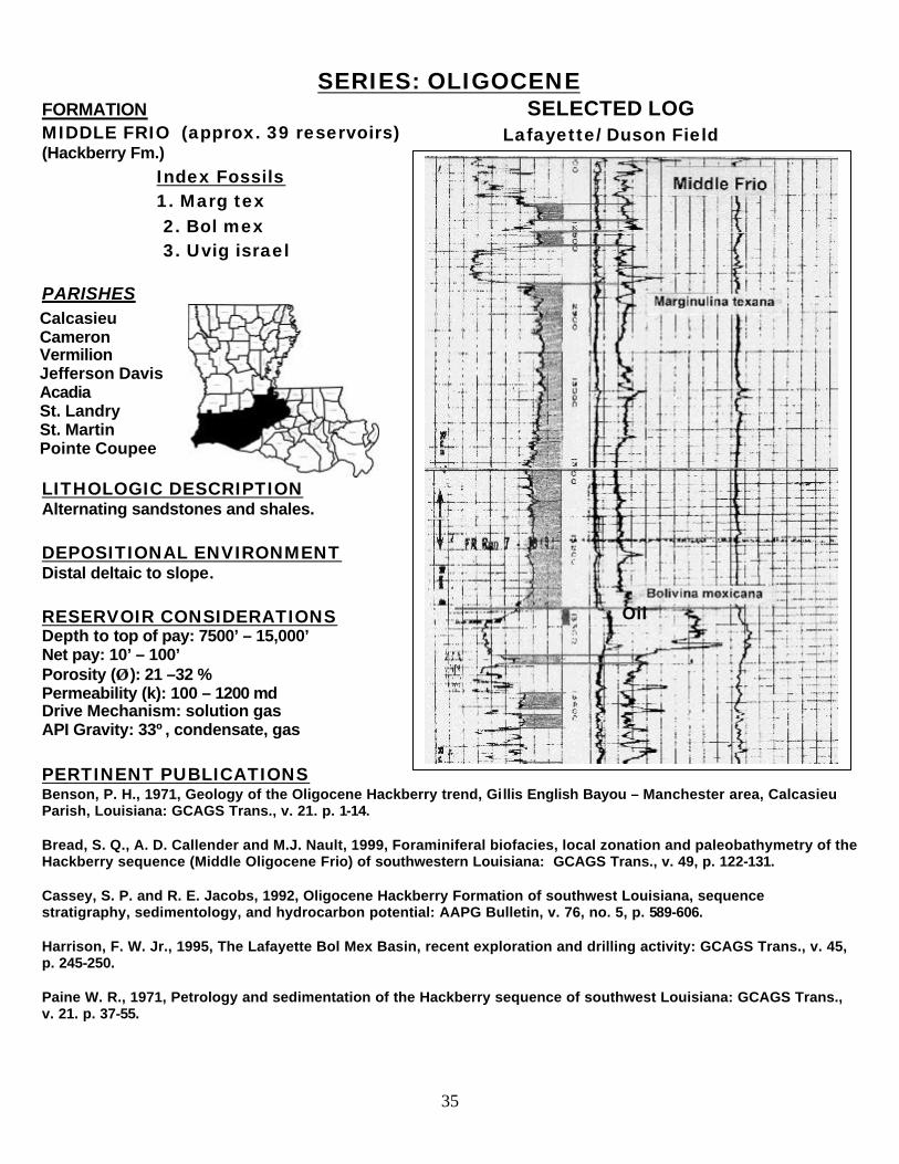
SERIES: OLIGOCENE FORMATION SELECTED LOG MIDDLE FRIO (approx. 39 reservoirs) (Hackberry Fm.)
Index Fossils 1. Marg tex 2. Bol mex 3. Uvig israel PARISHES
LITHOLOGIC DESCRIPTION Alternating sandstones and shales. DEPOSITIONAL ENVIRONMENT Distal deltaic to slope. RESERVOIR CONSIDERATIONS Depth to top of pay: 7500’ – 15,000’ Net pay: 10’ – 100’ Porosity (ÂÂ ): 21 –32 % Permeability (k): 100 – 1200 md Drive Mechanism: solution gas API Gravity: 33º, condensate, gas PERTINENT PUBLICATIONS Benson, P. H., 1971, Geology of the Oligocene Hackberry trend, Gillis English Bayou – Manchester area, Calcasieu Parish, Louisiana: GCAGS Trans., v. 21. p. 1-14. Bread, S. Q., A. D. Callender and M.J. Nault, 1999, Foraminiferal biofacies, local zonation and paleobathymetry of the Hackberry sequence (Middle Oligocene Frio) of southwestern Louisiana: GCAGS Trans., v. 49, p. 122-131. Cassey, S. P. and R. E. Jacobs, 1992, Oligocene Hackberry Formation of southwest Louisiana, sequence stratigraphy, sedimentology, and hydrocarbon potential: AAPG Bulletin, v. 76, no. 5, p. 589-606. Harrison, F. W. Jr., 1995, The Lafayette Bol Mex Basin, recent exploration and drilling activity: GCAGS Trans., v. 45, p. 245-250. Paine W. R., 1971, Petrology and sedimentation of the Hackberry sequence of southwest Louisiana: GCAGS Trans., v. 21. p. 37-55.
Calcasieu Cameron Vermilion Jefferson Davis Acadia St. Landry St. Martin Pointe Coupee
Lafayette/ Duson Field
Oil
36
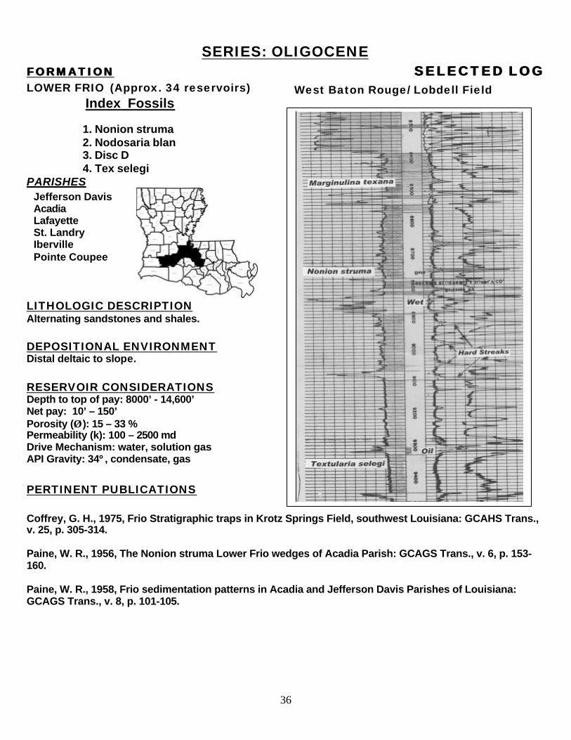
SERIES: OLIGOCENE FORMATIONFORMATION SELECTED LOGSELECTED LOG LOWER FRIO (Approx. 34 reservoirs) Index Fossils 1. Nonion struma 2. Nodosaria blan 3. Disc D 4. Tex selegi PARISHES
LITHOLOGIC DESCRIPTION Alternating sandstones and shales. DEPOSITIONAL ENVIRONMENT Distal deltaic to slope. RESERVOIR CONSIDERATIONS Depth to top of pay: 8000’ - 14,600’ Net pay: 10’ – 150’ Porosity (ÂÂ ): 15 – 33 % Permeability (k): 100 – 2500 md Drive Mechanism: water, solution gas API Gravity: 34º, condensate, gas
PERTINENT PUBLICATIONS Coffrey, G. H., 1975, Frio Stratigraphic traps in Krotz Springs Field, southwest Louisiana: GCAHS Trans., v. 25, p. 305-314. Paine, W. R., 1956, The Nonion struma Lower Frio wedges of Acadia Parish: GCAGS Trans., v. 6, p. 153-160. Paine, W. R., 1958, Frio sedimentation patterns in Acadia and Jefferson Davis Parishes of Louisiana: GCAGS Trans., v. 8, p. 101-105.
Jefferson Davis Acadia Lafayette St. Landry Iberville Pointe Coupee
West Baton Rouge/ Lobdell Field
37
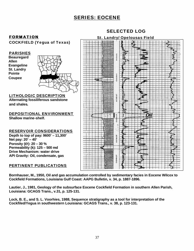
SERIES: EOCENE
SELECTED LOG FORMATION FORMATION COCKFIELD (Yegua of Texas) PARISHES
LITHOLOGIC DESCRIPTION Alternating fossiliferous sandstone and shales. DEPOSITIONAL ENVIRONMENT Shallow marine-shelf. RESERVOIR CONSIDERATIONS Depth to top of pay: 9600’ – 11,300’ Net pay: 20’ – 40’ Porosity (ÂÂ ): 20 – 30 % Permeability (k): 125 – 500 md Drive Mechanism: water drive API Gravity: Oil, condensate, gas PERTINENT PUBLICATIONS Bornhauser, M., 1950, Oil and gas accumulation controlled by sedimentary facies in Eocene Wilcox to Cockfield Formations, Louisiana Gulf Coast: AAPG Bulletin, v. 34, p. 1887-1896. Lautier, J., 1981, Geology of the subsurface Eocene Cockfield Formation in southern Allen Parish, Louisiana: GCAGS Trans., v.31, p. 125-131. Lock, B. E., and S. L. Voorhies, 1988, Sequence stratigraphy as a tool for interpretation of the Cockfiled/Yegua in southwestern Louisiana: GCAGS Trans., v. 38, p. 123-131.
Oil
Beauregard Allen Evangeline St. Landry Pointe Coupee
St. Landry/ Opelousas Field
38
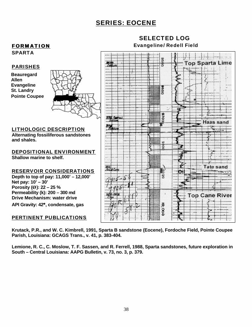
SERIES: EOCENE
SELECTED LOG FORMATION FORMATION SPARTA PARISHES
LITHOLOGIC DESCRIPTION Alternating fossiliferous sandstones and shales. DEPOSITIONAL ENVIRONMENT Shallow marine to shelf.
RESERVOIR CONSIDERATIONS Depth to top of pay: 11,000’ – 12,000’ Net pay: 10’ – 30’ Porosity (ÂÂ ): 22 – 25 % Permeability (k): 200 – 300 md Drive Mechanism: water drive
API Gravity: 42ºº , condensate, gas
PERTINENT PUBLICATIONS Krutack, P.R., and W. C. Kimbrell, 1991, Sparta B sandstone (Eocene), Fordoche Field, Pointe Coupee Parish, Louisiana: GCAGS Trans., v. 41, p. 383-404. Lemione, R. C., C. Moslow, T. F. Sassen, and R. Ferrell, 1988, Sparta sandstones, future exploration in South – Central Louisiana: AAPG Bulletin, v. 73, no. 3, p. 379.
Beauregard Allen Evangeline St. Landry Pointe Coupee
Evangeline/ Redell Field
Oil
39
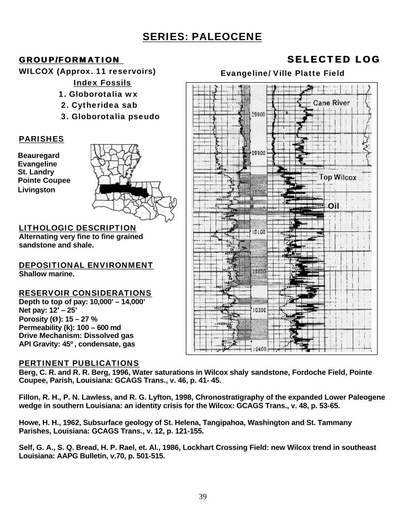
SERIES: PALEOCENE GROUP/FORMATION GROUP/FORMATION SELECTED LOGSELECTED LOG WILCOX (Approx. 11 reservoirs) Index Fossils 1. Globorotalia wx 2. Cytheridea sab 3. Globorotalia pseudo PARISHES
LITHOLOGIC DESCRIPTION Alternating very fine to fine grained sandstone and shale. DEPOSITIONAL ENVIRONMENT Shallow marine. RESERVOIR CONSIDERATIONS Depth to top of pay: 10,000’ – 14,000’ Net pay: 12’ – 25’ Porosity (ÂÂ ): 15 – 27 % Permeability (k): 100 – 600 md Drive Mechanism: Dissolved gas API Gravity: 45º, condensate, gas PERTINENT PUBLICATIONS Berg, C. R. and R. R. Berg, 1996, Water saturations in Wilcox shaly sandstone, Fordoche Field, Pointe Coupee, Parish, Louisiana: GCAGS Trans., v. 46, p. 41- 45. Fillon, R. H., P. N. Lawless, and R. G. Lyfton, 1998, Chronostratigraphy of the expanded Lower Paleogene wedge in southern Louisiana: an identity crisis for the Wilcox: GCAGS Trans., v. 48, p. 53-65. Howe, H. H., 1962, Subsurface geology of St. Helena, Tangipahoa, Washington and St. Tammany Parishes, Louisiana: GCAGS Trans., v. 12, p. 121-155. Self, G. A., S. Q. Bread, H. P. Rael, et. Al., 1986, Lockhart Crossing Field: new Wilcox trend in southeast Louisiana: AAPG Bulletin, v.70, p. 501-515.
Beauregard Evangeline St. Landry Pointe Coupee Livingston
Oil
Evangeline/ Ville Platte Field
40
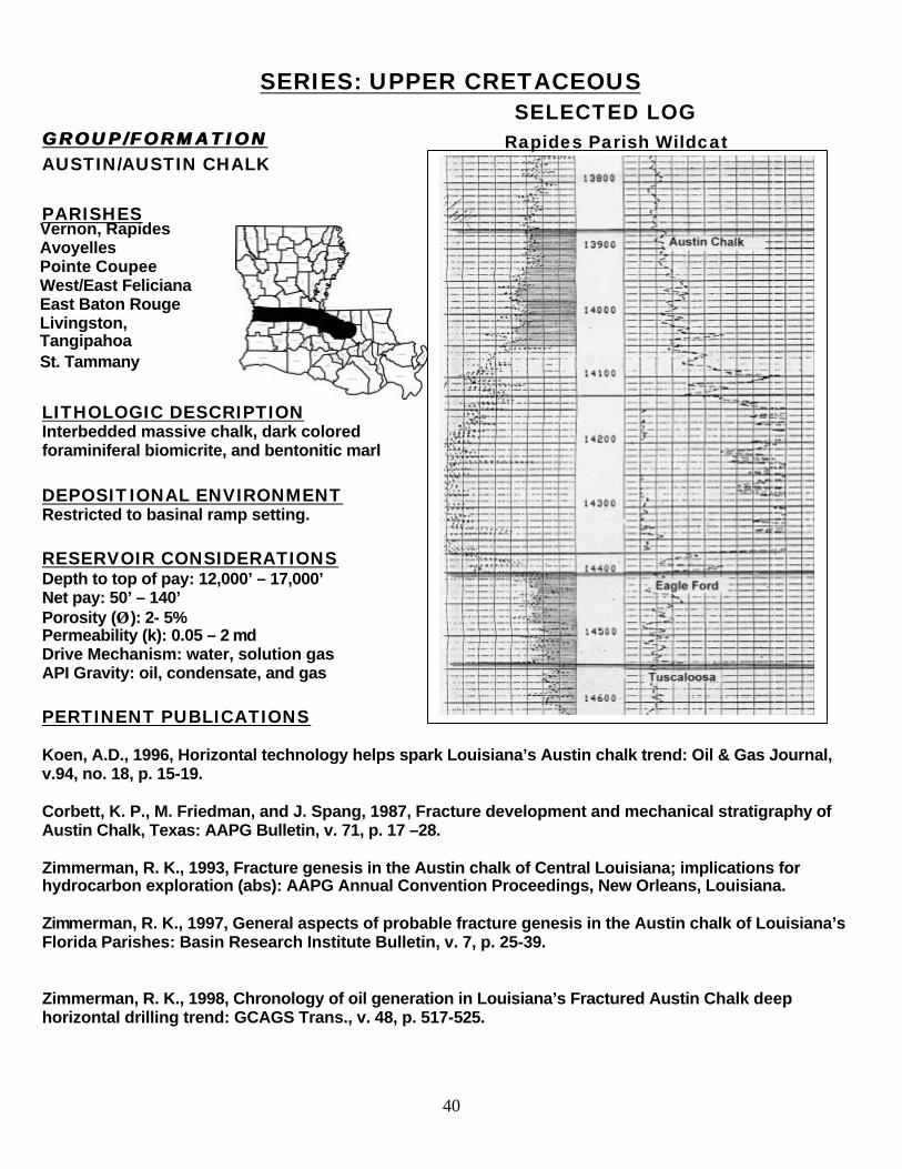
SERIES: UPPER CRETACEOUS SELECTED LOG GROUP/FORMATION GROUP/FORMATION AUSTIN/AUSTIN CHALK PARISHES
LITHOLOGIC DESCRIPTION Interbedded massive chalk, dark colored foraminiferal biomicrite, and bentonitic marl DEPOSITIONAL ENVIRONMENT Restricted to basinal ramp setting. RESERVOIR CONSIDERATIONS Depth to top of pay: 12,000’ – 17,000’ Net pay: 50’ – 140’ Porosity (ÂÂ ): 2- 5% Permeability (k): 0.05 – 2 md Drive Mechanism: water, solution gas API Gravity: oil, condensate, and gas PERTINENT PUBLICATIONS Koen, A.D., 1996, Horizontal technology helps spark Louisiana’s Austin chalk trend: Oil & Gas Journal, v.94, no. 18, p. 15-19. Corbett, K. P., M. Friedman, and J. Spang, 1987, Fracture development and mechanical stratigraphy of Austin Chalk, Texas: AAPG Bulletin, v. 71, p. 17 –28. Zimmerman, R. K., 1993, Fracture genesis in the Austin chalk of Central Louisiana; implications for hydrocarbon exploration (abs): AAPG Annual Convention Proceedings, New Orleans, Louisiana. Zimmerman, R. K., 1997, General aspects of probable fracture genesis in the Austin chalk of Louisiana’s Florida Parishes: Basin Research Institute Bulletin, v. 7, p. 25-39. Zimmerman, R. K., 1998, Chronology of oil generation in Louisiana’s Fractured Austin Chalk deep horizontal drilling trend: GCAGS Trans., v. 48, p. 517-525.
Vernon, Rapides Avoyelles Pointe Coupee West/East Feliciana East Baton Rouge Livingston, Tangipahoa St. Tammany
Rapides Parish Wildcat
41
SERIES: UPPER CRETACEOUS SELECTED LOG
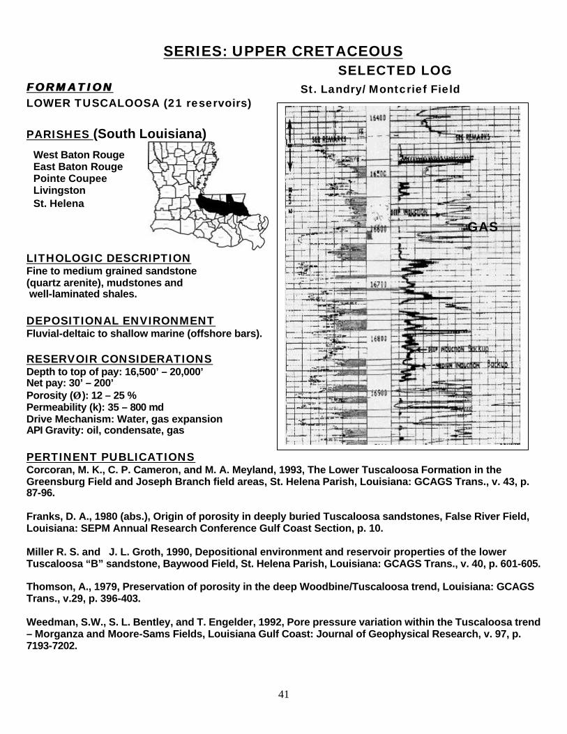
FORMATION FORMATION LOWER TUSCALOOSA (21 reservoirs) PARISHES (South Louisiana)
LITHOLOGIC DESCRIPTION Fine to medium grained sandstone (quartz arenite), mudstones and well-laminated shales.
DEPOSITIONAL ENVIRONMENT Fluvial-deltaic to shallow marine (offshore bars).
RESERVOIR CONSIDERATIONS Depth to top of pay: 16,500’ – 20,000’ Net pay: 30’ – 200’ Porosity (ÂÂ ): 12 – 25 % Permeability (k): 35 – 800 md Drive Mechanism: Water, gas expansion API Gravity: oil, condensate, gas PERTINENT PUBLICATIONS Corcoran, M. K., C. P. Cameron, and M. A. Meyland, 1993, The Lower Tuscaloosa Formation in the Greensburg Field and Joseph Branch field areas, St. Helena Parish, Louisiana: GCAGS Trans., v. 43, p. 87-96. Franks, D. A., 1980 (abs.), Origin of porosity in deeply buried Tuscaloosa sandstones, False River Field, Louisiana: SEPM Annual Research Conference Gulf Coast Section, p. 10. Miller R. S. and J. L. Groth, 1990, Depositional environment and reservoir properties of the lower Tuscaloosa “B” sandstone, Baywood Field, St. Helena Parish, Louisiana: GCAGS Trans., v. 40, p. 601-605. Thomson, A., 1979, Preservation of porosity in the deep Woodbine/Tuscaloosa trend, Louisiana: GCAGS Trans., v.29, p. 396-403. Weedman, S.W., S. L. Bentley, and T. Engelder, 1992, Pore pressure variation within the Tuscaloosa trend – Morganza and Moore-Sams Fields, Louisiana Gulf Coast: Journal of Geophysical Research, v. 97, p. 7193-7202.
West Baton Rouge East Baton Rouge Pointe Coupee Livingston St. Helena
GAS
St. Landry/ Montcrief Field
42
Author’s Biography
Donald A. Goddard is an Associate Professor at Louisiana State University’s Center For Energy Studies (CES). He serves as the Coordinator of the Central Gulf Region, Petroleum Technology Transfer Council (PTTC). In this capacity, with the help of the CGR/PTTC Producer Advisory Group (PAG), Dr. Goddard is responsible for identifying and transferring upstream technologies to Louisiana independent producers. He performs his duties as the PTTC coordinator in collaboration with LSU’s Petroleum Engineering Department (PETE), and Louisiana Geological Survey’s Basin Research Energy Section. Prior to joining LSU’s Center For Energy Studies he worked for four years as a petroleum consultant to international companies interested in Venezuela’s upstream activities. As Assistant Professor-Research at LSU’s Basin Research Institute (1991-1996), his research involved the characterization of Tertiary reservoirs in Central Louisiana, and participated on projects in basin analysis of the Gulf Coast Region. Dr. Goddard began his career in 1965 with Gulf Oil Co. (Mene Grande) in Eastern Venezuela. He has over twenty-five years of petroleum industry experience, both in exploration geophysics and production geology, having attained managerial positions in Maraven S. A., an affiliate of Petroleos de Venezuela (PDVSA). He obtained a B.S. degree in geology from Florida State University in 1965. Dr. Goddard later studied at the University of London where he obtained M.Sc. and PhD degrees in marine geology and geophysics. He also has a geological engineering degree from the Universidad Central de Venezuela. Dr. Goddard is a member of the American Association of Petroleum Geologists (AAPG), the Baton Rouge Geological Society (BRGS), the Venezuelan Geological Society (SVG), and the Society of Petroleum Engineers (SPE). Phone: (225) 578-4538 E-mail: [email protected]
September 2001


![Petroleum (Onshore) Act 1991 · Petroleum (Onshore) Regulation 2016 [NSW] Explanatory note Page 2 Published LW 12 August 2016 (2016 No 500) (q) the certificate of authority required](https://static.fdocuments.net/doc/165x107/5f169642ea28275573224bd6/petroleum-onshore-act-1991-petroleum-onshore-regulation-2016-nsw-explanatory.jpg)