Questions & Answers In Applied Geophysics
144
Questions & Answers Abdullah M. Al-Amri Dept. of Geology & Geophysics King Saud Univ. , Riyadh, Saudi Arabia In Applied Geophysics 12 ﺳﻠﺴﻠﺔ ﺍﻟﻌﻤﺮﻱ ﺍﻟﺠﻴﻮﻓﻴﺰﻳﺎﺋﻴﺔAl-Amri’s Geophysical Series 2020
Transcript of Questions & Answers In Applied Geophysics

Questions & Answers
Abdullah M. Al-AmriDept. of Geology & Geophysics
King Saud Univ., Riyadh, Saudi Arabia
300300300300300300300300300300300300300300300300300300300300300300300300300300300300300300300300300300300300300300300In
Applied Geophysics
12 Al-Amri’s Geophysical Seriesسلسلة العمري الجيوفيزيائية
2020

2
Electrical & EM Methods
© Abdullah Mohammed Alamri , 2020King Fahd National Library Cataloging-in-Publication Data
Alamri, Abdullah Mohammed 300 Questions & Answers In Applied Geophysics. /
Abdullah Mohammed Alamri .- Riyadh , 2020 250p ; ..cm
ISBN: 978-603-03-4779-7
1- Geophysics I-Title 550 dc 1441/12717
L.D. no. 1441/12717 ISBN: 978-603-03-4779-7
Please copy or reprint the above part as it at the back of the title page. ISBN should be printed again at the back cover of the book. TWO copies of the book must be submitted to KFNL, in addition to soft copy of the work saved on CD, Thanks.
p.144 ; 20.5 x 27 cm

3
91 Q & A
Preface
انطلاقاً من أهداف الجمعية السعودية لعلوم الأرض الرامية إلى نشر المعرفة والثقافة العلمية لخدمة المجتمع عامة والمهتمين بعلوم الأرض خاصة فقد أصدر المؤلف سلسلة علمية من ١٢ كتاب : ٦ كتب ثقافية و٤ كتب جيولوجية و٢ جيوفيزيائية. في مرحلة ما من حياتنا ، قد يُطلب من كل واحد منا إجراء اختبار للتحقق من صحة شهادة الثانوية العامة أو القبول في الجامعة أو الدراسات العليا أو التأهيل أو التسجيل أو الحصول على ترخيص
لمزاولة المهنة كجيولوجي أو جيوفيزيائي محترف. وتسهيلا لتحقيق الأهداف المرجوة وتذليل الصعوبات تم ذلك من خلال السلسلة الجيولوجية والجيوفيزيائية التي اشتملت على ٦ كتب عبارة عن ٢٠٢٠ سؤال وجواب في ١٠٠٠ صفحة أغلبها مدعم بالأشكال التوضيحية ا في هدفه. حاول المؤلف من المبسطة لمساعدة المهتم بعلوم الأرض في اجتياز الاختبار بشرط أن يكون مؤهلاً وجادً
خلال هذه السلسة قدر الإمكان تغطية تخصصات علوم الأرض ممثلة في ٦ أجزاء رئيسية :
أصل وتطور الأرض (علم الأحافير والطبقات الحيوي – جيوديناميكية باطن الأرض). •أسس الجيولوجيا ( علم الصخور والمعادن – الجيولوجيا التركيبية - الجيوكيمياء ). •
( GIS )الثروات الطبيعية ( البترول – المياه – الخامات الاقتصادية – الاستشعار عن بعد و •المخاطر الطبيعية ( الزلازل - البراكين – التسونامي – الانزلاقات الأرضية – الفيضانات – الانهيارات ). •
علم الزلازل ( الزلزالية الهندسية – هندسة الزلازل – تحليل المخاطر ). •الجيوفيزياء التطبيقية ( المقاومية الكهربائية – الكهرومغناطيسية – الجاذبية – الاستكشاف السيزمي). •
Based on the goals of the Saudi Society of Geosciences aimed at spreading scien�fic knowledge and culture to serve society in general and those interested in earth sciences in par�cular, the author has issued a scien�fic series of 12 books: 6 educa�onal books, 4 geological books and 2 geophysical books. At some point in our lives, each of us may be required to take a test to validate a high school diploma, admission to university or graduate studies, qualifica�on, registra�on, or obtain a license to prac�ce as a professional geologist or geophysicist.
In order to facilitate the achievement of the desired goals and overcome the difficul�es, the geological and geophysical series included 6 books consis�ng of 2020 ques�ons and answers on 1000 pages, most of which are supported by simplified illustra�ons to help those interested in earth sciences pass the test, provided that they are qualified and serious in their goal. The author tried, as much as possible, through this series to cover the disciplines of earth sciences represented in 6 main parts ( Series 7 - 12 ).

4
Electrical & EM Methods

5
91 Q & A
Due to the inherent ambiguities in geophysical methods, an integrated approach involving two or more techniques is recommended. Similar to other geophysical meth-ods, electrical (E)and electromagnetic (EM) methods also suffer from ambiguity in in-terpretation due to the phenomena of the ‘principle of equivalence’, especially for thin middle layer problems. As both methods depend on the same physical property, namely the electrical conductivity, conductivity variation with depth should be reflected in the measurements of both methods at least with varying response in different ways. For example, The electrical resistivity survey and electromagnetic methods have been used in groundwater investigation because of the close relationship between electrical conduc-tivity and the physical properties of aquifers (conductance and resistance). The ERI and EM methods have been used together for groundwater studies and have proven to be very effective and efficient.

6
Electrical & EM Methods

Questions & Answers
inElectrical & EM Methods
919191919191919191919191

8
Electrical & EM Methods
1 Classify Geophysical methods according to their sources ?
Passive methods (Natural Sources): Incorporate measurements of natural oc-curring fields or properties of the earth. Ex. SP, Magnetotelluric (MT), Telluric, Gravity, Magnetic.
Active Methods (Induced Sources) : A signal is injected into the earth and then measure how the earth respond to the signal. Ex. DC. Resistivity, Seismic Re-fraction, IP, EM, Mise-A-LA-Masse, GPR.
3 Are resistance and resistivity the same ?
Not the same. Resistance is relevant only to a particular measurement circuit. Units: Ohms. Resistivity is an intrinsic property of all physical materials. Units: Ohm-Meters. Resistivity is a property of a material, independent of the shape and size of the specimen, while resistance depends on the size and shape of the specimen or device, as well as on its resistivity.
2 What are Factors which control the Resistivity?
Geologic Age, Salinity, Free-ion content of the connate water, Interconnection of the pore spaces (Permeability), Temperature, Porosity, Pressure, Depth.

9
91 Q & A
4
5
6
7
8
What are Factors Influencing Electrical Conductivity in Rocks?
Compare and contrast the apparatus used for IP, SP, and resistivity surveys?
Distinguish the geological situations for which the following forms are most appropriate VES, Profiling, Imaging?
In modelling VES results, what assumptions are made about the subsurface?
Why is a Pseudo section so called ?
Porosity (connected/effective - fractures or pores, Pore saturation (% air or gas)Hydrocarbon Fluid Saturation , Water salinity (TDS), Clay Content, Metallic Sulfide, Mineral Content, Fluid temperature, Rock Matrix intrinsic resistivity
IP and resistivity both need arrays with four electrodes, with two used to inject current- which is periodically reversed-into the ground, but IP needs a more powerful current supply and the ability to measure the decay of current after it is switched off. SP uses two non-polarizing electrodes and does not inject current.
VES when subsurface likely to have near- horizontal layers. Profiling when there is lateral variation and Imaging when there is both lateral and vertical variation.
Layers close to horizontal (dips no more than 10o ), each with a uniform resis-tivity and therefore with abrupt interfaces.
The depth scale is arbitrary, and the value plotted at a given point reflect resis-tivities of the surrounding area as well. (even if the structure is truly 2D).

10
Electrical & EM Methods
9
10
Explain why IP but not resistivity is a suitable method for detecting disseminated ores. Explain why IP as well as resistivity is o�en suc-cessful for detecting massive sulphide bodies?
What is magnetic permeability?
The disseminated particles can each store and release charge, but as the con-ducting particles are separated the bulk conductivity of the rock remains low. Massive sulphides are often surrounded by disseminated ore.
Measure of the ability of a medium to become magnetized when an electro-magnetic field is imposed upon it assumed to be 1 for most geologic materials. The ratio between value for material and value for free space and Magnetite, iron–oxide cement, iron–rich soils all have high magnetic permeability

11
91 Q & A
11 What is the difference between GPR and EM methods?
For GPR, wavelengths were very short (often less than one meter). For other EM methods, wavelengths are very long. consider 10kHz waves, V=3x10⁸ m/s Wavelength= 30km. Wavelength is so much larger than the survey area that we consider it a constant source spatially and only consider time–varying proper-ties of the field. Very different from GPR.
12 What is conduction and example of values?
Conduct electricity by flow of electrons\n–ranges over ~5 orders of magni-tude\n–currents largely carried by ions in pore waters\n . Generally, Conduc-tivity↑ with porosity↑\n–Good Conductors\n –Seawater, metallic ores\n –Shales, clays, contaminated water, sulfide\n–Poor Conductors\n –Dry quartz sand, granite\n –Limestone, dolomite, evaporates.

12
Electrical & EM Methods
13
14
15
What fundamental properties are important to EM methods?
What do we measure for all active sources?
What is fundamental about geophysics?
EM properties change with Frequency (f) of applied alternating current\n–Low frequency inputs = constraints on conductivity\n–High frequency inputs = info on dielectric properties (10–1000MHz)
Resistivity – voltage directly related through Ohm’s Law to resistance. EM – voltage is related to conductivity structure of the subsurface; induced second-ary magnetic field generates a secondary voltage. Seismic– measure original source itself.
Takes advantage of variable physical properties, physical property contrasts: Gravity measures: density; Magnetics measures magnetic susceptibility; seis-mology measures velocity and density (ie. acoustic impedance); radar mea-sures dielectric constant; Em measure conductivity and is therefore good for measuring fluids.

13
91 Q & A
16
17
18
What do we use to make geophysical observations?
How can the subsurface vary in terms of physical properties?
What observations can we use to infer porosity and why?
Variations in physical properties of the subsurface; measure the physical fields they produce; infer the structure from that rather than physically mapping.
Deformation in response to a stress; magnetic properties (susceptibility– abili-ty to become magnetized); conductivity; other electrical properties of materi-als (ability to store a charge)
Conductivity because more water increases conductivity and density because the more porous something is the less dense it is.

14
Electrical & EM Methods
19
20
21
22
How is temperature related to stress and strain, as well as magnetics?
What are we trying to determine with geophysical measurements?
What is a passive source?
How is GPR similar to seismic?
Temperature relates to stress and strain; mag susceptibility ( no magnetization above the Currie point);
lithology/porosity/permeability.
Measure existing field to tell us about properties; no source provided; passive fields not constant and need to be accounted for laterally; both fields have temporal and spatial changes which need to be accounted for accurately to produce accurate measurements of desired field.
Similar to seismic reflection in terms of processing; Biggest differences are EM waves, and Frequency – huge effect on resolution so we can see cm’s; but quicker attenuation limits to a meters; outcrop scale. Applications – similar to seismic but at smaller scale. Use common offset approach. Use CMP to get velocity so can convert time to depth.

15
91 Q & A
23
24
26
25
How does conductivity effect the depth of penetration in GPR?
How is GPR measured?
Difference in resistivity and conductivity measurements?
What is frequency domain electromagnetics?
High conductivities at the surface will eat up your signal, EX– clay; controls where you can use the method; sand good.
Change in dielectric constant (ability of material to store a charge) but not mapping, make an image; unitless; water table very easy to see; very sensitive to water, Stack offsets like in seismic; units of nanoseconds; quick trace.
Instead of measuring apparent conductivity, estimate resistivity; Measuring voltage, inject a direct current in direct contact with ground (unlike EM which is an induction method).
Two coils, initial coil that you pass a current through generates a primary mag-netic field, goes into subsurface, if conductor…creates voltage which induces a secondary magnetic field which produces a secondary voltage which you mea-sure at your second coil. Look at ratio of primary to secondary voltage in terms of apparent conductivity, which can make a map of.

16
Electrical & EM Methods
27
28
What are the advantages and disadvantages of e-m surveying com-pared to resistivity surveying for ground surveying?
Describe in geophysical terms the type of target that can be found using GPR. Give two examples in geological terms?
EM but not resistivity operates when the surface layer is very resistive. Con-versely, it is has less penetration if the surface layer is very conductive:; re-sistivity gives more precise location of bodies; e-m is usually easier to use as electrodes do not have to be moved.
Sub horizontal interfaces between layers with contrasting velocity/ permi�v-ity, not more than a few meters deep, depending on the conductivity , which should be low. Water table, sand/ clay interfaces.

17
91 Q & A
29
31
30
How does MT differ, in application and method, from the other meth-ods?
Which is the most suitable system for airborne surveying.
Describe how you would solve the following problems using e-m methods?
Measures resistivities down to tens or hundreds of kilometers, uses low –fre-quency natural variations of the magnetic field.
Slingram
a. To locate a near-vertical fault zone in granite beneath 1 to 2 m of boulder clay. VLF or EM16.b. To measure the thickness of dry sand ( up to 4 m) over shale.Slingram system.c. To locate any clay-filled, steeply dipping faults in an proposed extension to a limestone quarry, beneath a shallow layer of soil.Profiling using Slingram system with 10 m separation. VLF with TX aligned along strike of the fault.d. To measure the depth to the water table (30-80 m) in sandstone.TEM sounding.e. To map the steeply dipping contact between sandstone and shale, beneath about 1 m of sandy soil.Profiling using Slingram with 4 m separation.f. To investigate if there is saline water within an aquifer lying between 15-50 m, in chalk.Expanding Slingram up to 40 m or more separation. TEM.

18
Electrical & EM Methods
32
33
34
35
36
Explain why the amplitude of an e-m signal generally decreases with distance from thesource.
What are the advantages of the TEM compared to the Slingram method.
What factors limit the vertical resolution of a GPR survey ?
Give two general reasons why geophysical logging would still be need-ed in hydrocarbon exploration even if complete cores were available.
In what circumstances are radioactivity logs preferred to electrical ones ?
Geometrical spreading, attenuation in conductive rocks.
As readings are taken after the TX is switched off, there is no need to cancel accurately the TX signal at the receiver, and sensitivity can be higher; these are particularly valuable advantages for aerial surveys.
Need high frequency for high resolution, but higher frequencies are more rapidly attenuated by conductive overburden, so may need to decrease frequency to get required penetration.
Boreholes only sample locally; core samples may be altered by the drilling, e.g., loss of original fluids; some formations may not be sampled at all due to wash out.
In a cased hole or a dry hole, or a hole with oil-based mud.

19
91 Q & A
37
38
39
40
What are the main factors that determine the electrical resistance of a formation ?
Explain the uses of SP logs in (a) hydrocarbon exploration and (b) min-eral exploration?
If you suspected a lithology was dolomite, how would you confirm this and measure its composition using logs ?
Why can the sonic log provide more precise estimates of seismic ve-locities and more precise locations of interfaces than surface seismic reflection surveys ?
Porosity, water saturation, water resistivity.
(a) Locating shale-sand contacts, and measuring shale contamination of sand, needed to evaluate the hydrocarbon saturation.
(b) To locate most massive sulphide ores (not sphalerite) and graphite.
Use a sonic log / neutron log cross plot: expect values to fall between limestone and dolomite lines; deduce composition in proportion to position between the two lines along a line of equal porosity.
It is adjacent to the formation whose velocity is being measured, and it mea-sures the velocity directly (using seismic refraction methods) rather than in-directly, through moveout; because it does not need to penetrate far, much higher frequencies can be used, giving higher resolution.

20
Electrical & EM Methods
41
42
Name three logs that would probably reveal the presence of shale.
How are water saturation and hydrocarbon saturation related ?
SP (low value between higher ones), natural alpha ray (high reading), caliper (wide diameter)
Sw = ( 1 – Shc )
43
A plane electromagnetic (EM) wave travelling vertically downwards with a frequency of 1000 Hz in a homogeneous medium has a skin depth of 100 m. The ratio of the amplitude of the EM wave at a depth of 75 m with respect to the amplitude at the Earth’s surface is
0.46 to 0.49.
44
A student interpreted a four layer Schlumberger resistivity sounding data and obtained the resistivities (P) and thicknesses (h) as follows: P1=100 ohm. m, P2=20 ohm.m, P3=1500 ohm.m and P4=50 ohm.m; h1=50 m, h2=10 m and h3=20 m. The same data is interpreted by an-other student who obtains P3=2000 ohm.m. Then, according to the principle of equivalence, the value of h3 interpreted by the second student is
15 to 15 m.

21
91 Q & A
45
46
47
48
The apparent resistivities obtained at 0.1 Hz and 10 Hz in the frequen-cy domain I.P. measurement are 100 ohm.m and 80 ohm.m, respec-tively. The Percentage Frequency Effect is
A 15 Volt power supply is applied across a cylindrical container (diam-eter = 0.20 m and length = 0.50 m). Currents of 750 mA and 500 mA are measured when the container is filled with (i) brine only, and (ii) rock sample fully saturated with brine, respectively. The formation factor of the rock sample is
If the fresh water in the pores of a disseminated lead sulphide ore were replaced by saline water, how would this affect the values of the frequency effect and metal factor ?
What is the frequency range for GPR?
25 to 25.
1.5 to 1.5 .
The value of FE but NOT MF would increase.
GPR: 100MHz – 1 GHz
22
Electrical & EM Methods
50
51
52
Is defined as 1/ρ and is measured in Siemens per meter.
Four electrodes are placed along a straight line in the same order AMNB , but with AB ≥ 5 MN.
The object is to deduce the variation of resistivity with depth
A. Resistivity C. Self potentialB. Conductivity D. Induced polarization
A. Schlumberger C. WennerB. Dipole-Dipole D. Lee-Wenner
A. HEP C. SPB. VES D. IP
49 ………………………………………….. is used for deep penetration?
Dipole – Dipole Array.
23
91 Q & A
53
54
55
56
Incorporate measurements of natural occurring fields or properties of the earth is :
Which of the following factors would decrease the resistance through an electrical cord?
What is the basic idea of SP?
What is the origin of SP ?
A. Passive C. IPB. Natural D. SP
A. Increasing the length of the cordB. Increasing the resistivityC. Decreasing the cross-sectional areaD. Increasing the cross-sectional area
Self-potential method (SP) is to measure natural potential differences in the subsurface (without injecting current).
Origin of SP: Spontaneous polarization occurs about dissimilar materials, near varying concentrations of electrolytic solutions, and due to the flow of fluids (electrokinetic effect).

24
Electrical & EM Methods
57
58
What is the controlling factor of SP?
Where do we find (large) SPs ?
The controlling factor is underground water, be it simply by flowing through pore space (streamline potential), be it by electrochemical effects.
In zones containing sulfides, magnetite, graphite.
59
60
What are advantages and shortages of SP?
What is the mechanism of SP?
Advantage: measurement is simple. Very well suited for detecting metallic bodies in the subsurface. SP measurements useful for resistivity measurements to eliminate background noise. The shortages are qualitative, low penetration depth (30 m).
A. Streaming potential caused by flow of a liquid with certain electrical properties under a pressure gradient through a membrane , pi pe, capillary, or porous medium (with different electrical properties).
B. diffusion potential is caused by the displacement of ionic solutions of dissimilar concentrations.
C. Nernst, or shale, potential occurs when similar conductors have a solution of differing concentrations about them.
D. Mineralization, or electrolytic contact, potential is produced at the surface of a conductor with another medium.

25
91 Q & A
61
62
63
What is Polarization ?
What is meant by IP?
Why is induced polarization surveying important?
Polarization is a geophysical phenomenon which measures the slow decay of volt-age in the ground after the cessation of an excitation current pulse (time domain method) or low frequency variation of the resistivity of the earth (frequency domain method).
Induced polarization (IP) is the Earth’s capacity to hold an electric charge over time. IP measures the voltage decay curve after the injected current is shut off. The higher the IP, the longer over time the charge is held—IP decays over time, typically a few seconds but sometimes up to minutes, and will eventually disappear. IP is especially useful for mineral exploration applications.
The induced polarization method makes use of the capacitive action of the subsurface to locate zones where clay and other chargeable minerals are located within the host rock. With IP, you can tell very distinctly what is in the ground if it holds a charge because you end up with two maps—i.e., resistivity and IP—at the same time. This is important for mineral exploration—identifying economically important minerals, including gold, copper, and silver. Early on, pyrite and massive sulfide minerals were deposited by hydrothermal fluids. These minerals have a huge IP signature, especially when disseminated as smaller grain in a rock matrix, which we can use when exploring for these minerals.

26
Electrical & EM Methods
64
65
What is induced polarization surveying used for?
Express the resistivity in terms of temperature ?
IP is used predominantly in the mining industry for mapping of disseminated sulfide bodies and other ore exploration, and it can also be used for environmental purposes and research
The resistivity of all materials depends on temperature. Some even become superconductors (zero resistivity) at very low temperatures. Ρ is resistivity,
66 What is the reciprocal of resistivity and its unit?
Reciprocal of resistivity is called conductivity. Unit of conductivity is “ mho / m “
Ρ is resistivity, ρ0 is original resistivity, ΔT is temperature change 𝛼𝛼 is coefficient of temperature.Ρ = ρ0 ( 1 + 𝛼𝛼𝛼𝛼𝛼𝛼 )
67The resistance of an electric wire of an alloy is 10 Ω. If the thickness of wire is 0.001 meter, and length is 1 m, find its resistivity.

27
91 Q & A
68
69
70
If the resistance of coil is 3 Ω at 20 0C and α = 0.004/0C then deter-mine its resistance at 100 0C.
What is TEM and FEM?
What is the advantage of EM methods?
The electromagnetic techniques have the broadest range of different instrumental systems. They can be classified as either time domain (TEM) of frequency domain (FEM) systems. FEM: use one or more frequencies: Measurements as a function of time. EM methods can be either passive, utilizing natural ground signals (e.g. magnetotellurics) or active, where an artificial transmitter is used either in the near field (as in ground conductivity meters) or in the far field (using remote high powered military and civil radio transmitters as in the case of VLF and RMT methods).
The main advantage of the EM methods is that they do not require direct contact with the ground as in the case of DC methods. Therefore the EM measurements can be carried out in a faster way than the DC measurements. The range of EM applications is large. It is dependent upon the type of equipment.
R0= 3 Ω, T = 100ºC, T0 = 20ºC α = 0.004/ºC, RT = ? , RT= R0 (1 + α (T-‐T0) R100 = 3(1 + 0.004 × 80) = R100 = 3(1 + 0.32) R100 = 3(1.32) = R100 = 3.96 Ω

28
Electrical & EM Methods
71
72
73
What are the main applications of EM methods?
Discuss Depth of penetration in EM field?
What is the source of VLF method?
Mineral exploration, Mineral resource evaluation, Groundwater surveys, Map-ping contaminant plumes, Geothermal resource investigations, Contaminated land mapping, Landfill surveys, Detection of geological and artificial cavities, Location of geological faults, etc. Geological mapping, Permafrost mapping, etc.
The depth of penetration of an electromagnetic field depends upon its Frequency and the Electrical conductivity of the medium. The amplitude of EM fields decreases exponentially with depth. The amplitude of EM radiation as a function of depth relative to its original amplitude A0 is given by Ad = A0 e−1.The depth of penetration can be defined as the depth at which the amplitude Ad is decreased by the factor e 1compared with its surface amplitude. Penetration depth d is given by:
D = 503 ( ρ / f ) 0.5 .
Source of the VLF method is electro magnetic radiation generated in the low frequency band of 15 -25 kHz by the powerful radio transmitters used in long range communication and navigational systems.

29
91 Q & A
74
75
What is GPR?
List applications of GPR?
GPR is a technique of imaging the subsurface at high resolution. A radar system comprises a signal generator, transmi�ng and receiving antennae and a receiver that may have recording facilities. In the GPR method, a short radar pulse in the frequency band 10MHz 1GHz is introduced in the ground. The reflection of electromagnetic waves are observed. Radar velocities are controlled by the dielectric constant magnetic permeability.
Contaminant plume mapping, landfill investigations, location of buried fuel tanks and oil drums, detection of natural cavities and fissures, void detection, ice thickness mapping, location of buried archaeological objects.

30
Electrical & EM Methods
76
77
Define TEM method?
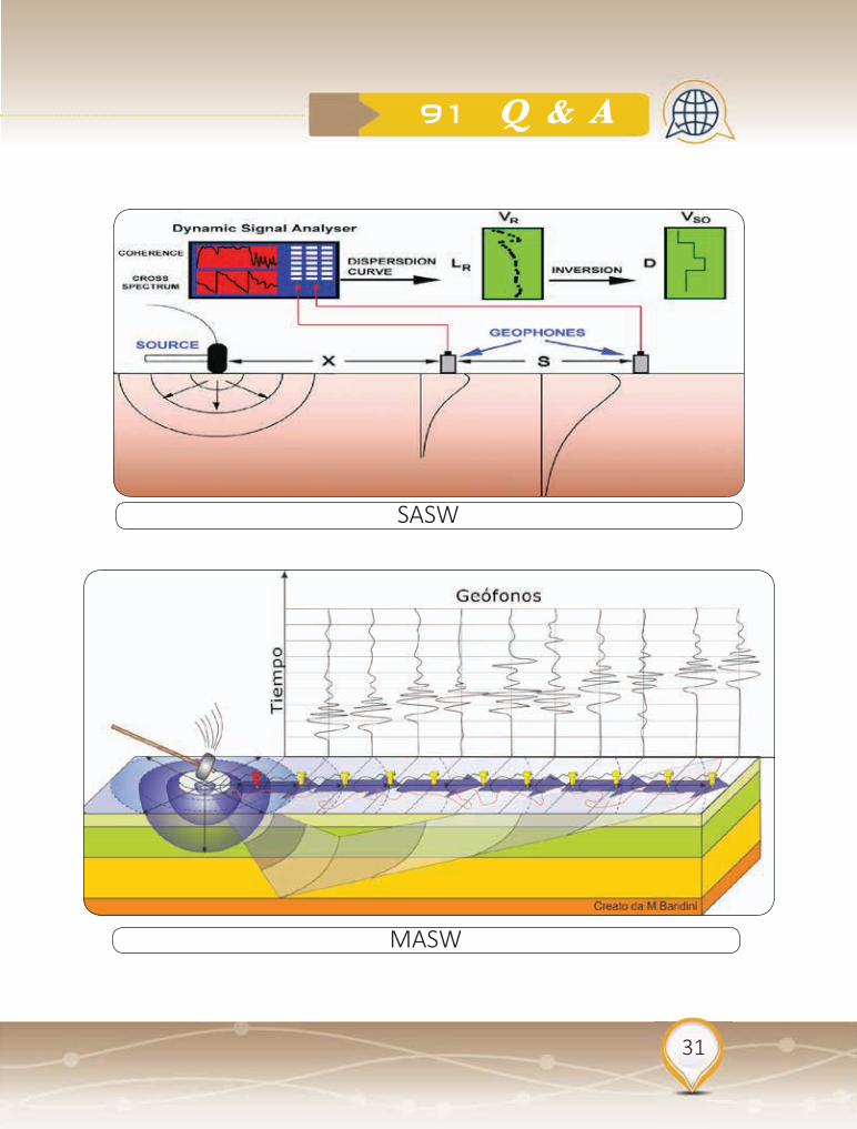
What is SASW and MASW?
The transient electromagnetic (TEM) method, alternately called time-domain EM (TDEM) or pulse EM (PEM), is a commonly-used, non-intrusive, geophysical method for obtaining subsurface resistivity-conductivity data. Because rock conductivity strongly correlates to rock properties, TEM is an effective way to map changes within rock or soil, for example, clayey layers restricting groundwater flow, conductive leachate in groundwater, and seepage in earthen embankments. TEM methods have been used in mineral exploration for more than half a century and are now used for an extremely broad range of applications in exploration, engineering, and environmental investigation. The depth of investigation can vary from 10s of meters to over 1000 meters, depending upon the size of the transmitter loop being used.
SASW is a single channel method with acquisition of shear wave velocities beneath a single point on the surface. To investigate Rippability, Depth to bedrock studies, Detect presence of subsurface voids, caves, fractures.MASW is a multi-channel method that can create a 2D cross-sectional view of subsurface shear wave velocities.
31
91 Q & A
SASW
MASW

32
Electrical & EM Methods
78 Define Anisotropy and its parameters?
Anisotropy : is a characteristic of stratified rocks which is generally more conducive in the bedding plane. The anisotropy might be find in a schist (micro anisotropic) or in a large scale as in layered sequence of shale (macro anisotropic). Four electrical parameters can be derived for each layer from the respective resistivity and thickness. There are :
• Longitudinal conductance SL= h/ρ = h.σ• Transverse resistance T = h.ρ• Longitudinal resistivity ρl = h/S • Transverse resistivity ρt = T/h
Anisotropy = Transverse resistivity ρt / Longitudinal resistivity ρl
79Why the presence of clay m inerals tends to decrease the Resistivity because?
• The clay minerals can combine with water . • The clay minerals can absorb cations in an exchangeable state
on the surface. • The clay minerals tend to ionize and contribute to the supply of
free ions.

33
91 Q & A
81 Solve for resistivity parameters?
80 What is Archie’s Law applied for?
Is an empirical relationship defining bulk resistivity of a saturated porous rock. In sedimentary rocks, resistivity of pore fluid is probably single most important factor controlling resistivity of whole rock. Archie (1942) developed empirical formula for effective resistivity of rock:

34
Electrical & EM Methods
82 What is Apparent resistivity?
Apparent resistivity is the resistivity we would get assuming that no boundary or change in resistivity is present. So that apparent resistivity equation is identical to the equation above for a material with constant resistivity.
83 Define Schlumberger arrangement in resistivity?
This array is the most widely used in the electrical prospecting . Four electrodes are placed along a straight line in the same order AMNB , but with
⎥⎥⎥⎥⎥
⎦
⎤
⎢⎢⎢⎢⎢
⎣
⎡⎟⎠
⎞⎜⎝
⎛−⎟⎠
⎞⎜⎝
⎛
××=MN
MNAB
IVa
22
22πρ
AB ≥ 5 MN
This array is less sensitive to lateral variations and faster to use as only the current electrodes are moved.

35
91 Q & A
84 List basic types of Dipole-Dipole arrangement?
Four basic dipole- dipole arrays . 1. Azimuthal 2. Radial 3. Parallel4. Perpendicular
When the azimuth angle (Ө ) formed by the line r and the current dipole AB = π /2 , The Azimuthal array and parallel array reduce to the equatorial Array. When Ө = O , the parallel and radial arrays reduce to the polar or axial array . If MN only is small is small with respect to R in the equatorial array, the system is called Bipole-Dipole (AB is the bipole and MN is the dipole ), where AB is large and MN is small. If AB and MN are both small with respect to R , the system is dipole- dipole

36
Electrical & EM Methods
85
86
What is the object of VES and HEP?
In case of three jorizontal layer resistivities with two interface case, how many curve types we get?
The object of Vertical Electrical Sounding (VES) is to deduce the variation of resistivity with depth below a given point on the ground surface and to correlate it with the available geological information in order to infer the depths and resistivities of the layers present. The object of Horizontal Electrical Profiling (HEP) is to detect lateral variations in the resistivity of the ground, such as lithological changes, near- surface faults.
We will get four possible curve types as follows : • Q – type ρ1> ρ2> ρ3 • H – Type ρ1> ρ2< ρ3 • K – Type ρ1< ρ2> ρ3 • A – Type ρ1< ρ2< ρ3

37
91 Q & A
88 Describe Electrical Resistivity Tomography (ERT)?
ERT method is an electrical testing method where current is induced in the ground using two current electrodes. The electrical potential drop is then read using two other electrodes. ERT can be used to map geologic variations including: soil lithology (e.g., clay versus gravel), presence of ground water, fracture zones, variations in soil saturation, areas of increased salinity. ERT is often the best option for mapping cavities such as caves, karst and/or evaporite dissolution sinkholes. Like seismic the electrical method has the capacity to yield either 1D (sounding), 2D (profile) or 3D (volume) imaging.
87 What is the functionof and application of Magnetotelluric method?
The magnetotelluric (MT) method is a passive electromagnetic (EM) exploration method that measures orthogonal components of the electric and magnetic fields on the Earth’s surface. The source field is naturally generated by variations in Earth’s magnetic field, which provide a wide and continuous spectrum of EM field waves. These fields induce currents into the Earth, which are measured at the surface and contain information about subsurface resistivity structures.Because MT surveys have relatively low resolution but excellent depth penetration, the measurements are used to help interpret regional geology. The MT method is particularly useful in areas where topography, high-impedance volcanic rocks or salt make other geophysical methods difficult. MT is one of the few techniques capable of sensing through the Earth’s crust to upper mantle.

38
Electrical & EM Methods

39
91 Q & A
Define Frequency-Domain Electromagnetics (FDEM)?
FDEM method is based on the induction of electrical currents in subsurface conductors by electromagnetic waves which are generated on the surface. A transmitter loop generates a controlled current that propagates into the subsurface. As the EM energy encounters different subsurface materials, eddy currents are induced, and secondary EM fields are generated. This secondary field is then recorded at the surface by a receiver loop. A data logger measures the components of the secondary field that are in-phase with the transmitted EM energy, and that portion which is 90-degrees out of phase (the quadrature component).
FDEM can be used to map lateral variations in moisture related to seepage through dams, levees, pipelines, or containment walls. It can also be used to delineate the edges of landfills or to detect burred metal objects such as utilities or underground storage tanks.
89

40
Electrical & EM Methods

41
91 Q & A
90Calculate the potential at ρ1, due to a current at C, of 0.6 ampere. The material in this section view extends to infinity in all directions. The bold line represents an interface between p1- and p2-material.

42
Electrical & EM Methods
91
A cable 1500 km in length might be installed to service observatories. The cable had a copper conductor with a cross section diameter of 0.4 cm. If they send 10 amps down the cable, what will the voltage drop be from shore to the end of the cable?
ρ*(length)*
A = 1.7x10-8 Ωm x 1500000m/(π (0.004)2m2) = ~507Ω m total cable resistance

Questions & Answers
inGravity & Magnetics
111111111111111111111111111

44
Questions & Answers in Gravity

45
111 Q & A
Gravity and magnetic geophysical methods are passive. They rely on no controlled sources but seek out naturally occurring variations in the earth’s gravity and magnetic fields. Magnetic methods are more popular in mineral exploration than gravity, not least because magnetic data can be quickly recorded from the air and in conjunction with other geophysical surveys. Land gravity surveys, by contrast, may require greater field efforts , more time, and more commitment of scarce capital. Besides, metal ores can be magnetic as well as electrically conductive, whereas high density of host rocks or limited deposit volume may leave ore deposits without clear gravity signatures. Interpretations of gravity and magnetic data are non-unique, meaning that sometimes a number of different geological models can fit the observed data. Magnetic data interpretation can be a useful way to investigate the deepest and often the most fundamental structure of a basin. Gravity anomalies originate from any subsurface density contrast, .e.g. intrusions, faults, basin boundaries, salt diapirs, etc.
46
Questions & Answers in Gravity
1 Classify Earth’s Magnetic Field.
The earth’s magnetic field can be separated into three parts:The main magnetic field: which is produced in the outer core and accounts for the very large regional variations in the field intensity and direction.The external magnetic field: which is produced by electric currents in the earth’s ionosphere.The anomalous magnetic field: which is produced by ferromagnetic minerals in the earth’s crust.
2 What is the Magnetic force and Magnetic field strength.
analogous to gravitational force , μ is magnetic permeability (=1 for vacuum, air)m is magnetic pole strength Magnetic field strengthAnalogous to gravitational acceleration. force per unit pole strength (force exerted on unit magnetic pole)

47
111 Q & A
3 Define Magnetic quantities ?
Three magnetic quantities are defined :
1. Magnitude.
2. Magnetic inclination (Direction with respect to horizontal) I = 90o at N. poles, - 90o at south pole., I = Ø at the equator.
3. Magnetic Declination (Direction with respect to geographic north). The lines of force are directed outward from positive North (N+) pole and inward to a negative (S-) pole.
4Prove that the total magnetic field (F) at north pole is twice as at the equator?
The total field F is resolved into its horizontal components H ( x , y ) and it vertical components Z. The angle which F makes with its horizontal components H is the inclination (I), and the angle between H and X (points North) is the declination (D).

48
Questions & Answers in Gravity
5 What are the similarities between Gravity and Magnetics ?
Geophysical exploration techniques that employ both gravity and magnetics are passive. Both are often referred to as potential methods, Identical physical and mathematical representations can be used (LaPlace’s Equation) to understand magnetic and gravitational forces. The acquisition, reduction, and interpretation of gravity and magnetic observations are very similar Both gravity and magnetic vary in time and space and used as reconnaissance tools.
6 What are the dissimilarities between Gravity and Magnetics ?
Gravity variations is controlled by rock density and magnetic field variations is controlled by magnetic susceptibility. The gravitational force is always attractive, whereas the magnetic force can be either attractive or repulsive. Single magnetic point sources (monopoles) can never be found alone in the magnetic case. Rather, monopoles always occur in pairs ( dipole ), which always consists of one positive monopole and one negative monopole. A properly reduced gravitational field is always generated by subsurface variations in rock density.A properly reduced magnetic field, however, can have as its origin at least two possible sources. It can be produced via an induced magnetization, or it can be produced via a remnant magnetization. Gravitational field does not change significantly with time, whereas the magnetic field is highly time dependent. Gravity requires 0.1 ppm accuracy, magnetic > 10 ppm. Gravimeter is relative instrument; magnetometer is absolute. Densities vary from 1 to 4; susceptibility over several orders of magnitude. Gravity anomalies smooth, regional; magnetic anomalies sharp, local. Tides are only external gravity effect, can be corrected. Effect of magnetic storms cannot be removed. Gravity corrections: drift, latitude, free air, Bouguer, terrain, etc.; magnetic corrections: ± drift. IGRF gravity surveys slow, expensive; magnetic costs about 1/10 of g.

49
111 Q & A
7 What are time variations in the Earth magnetic field?
a- Secular variation : slow change in I , D over a period of time.
b- Diurnal variation : every day → ± 30 nT
c- Lunar variation : every 25y → ± 2 nT
d- Magnetic storms : changes with latitude → ± 1000 nT
8 Explain Remnant magnetization of rocks ?
Remnant field (remains even after external field removed) :a. thermoremanent b. detrital remnant c. chemical remnant.Total magnetization (J) = Remanent (Jr) + induced (Ji)intensity of Jr is large in igneous and thermally metamorphosed Rocks. Koenigsberger ratio. Q = Remanent (Jr) / induced (Ji) Q > 1, Jr of sediments is smaller than Ji.

50
Questions & Answers in Gravity
9
10
What types of Magnetic Anisotropy of Rocks ?
List major Applications of Rock magnetism in paleomagnetism ?
Two types of anisotropy.
1.When the shape of the magnetically isotropic grains in a rock is elongated along a special direction, K may become anisotropic. This is called the shape anisotropy and dominates in magnetite.
2. In some rocks, the major ferromagnetic minerals themselves have a marked magneto crystalline anisotropy depending on the direction of Hex (ex. Ilmenite - hematite series, pyrohotite).
Reversals of the earth’s field. (most recent reversal about 20.000 y. ago., 50/50 N/R.Sea floor spreading.Secular variation and paleo intensity of the earth field.Polar wander and continental drift.Paleo climatology.Magnetic dating of rocks by :
• secular variation 103 y.• polarity zones 104 – 106 y.• average paleomagnetic pole positions 107 – 109 y.
Q ratio. Tectonic movements involving rotation.

51
111 Q & A
11 How does relative gravimeters work?
Based on the Zero Length Spring, by holding K constant in Hooke’s Law; temp causes instrument drift – so must measure change in time to correct.
12
13
Why are simple shapes important for calculating gravity?
What is dri� correction?
Simple shapes have analytical solutions for the anomaly they produce, helps with survey design
Dri� correction is used to adjust for instrument drift during measurements.
14 What is a latitude correction?
Since the earth is actually a geoid rather then a perfect sphere latitude correction is used to correct for measurements based on the latitudinal location on the earth.

52
Questions & Answers in Gravity
15 What is terrain correction?
Terrain correction is based on unevenness of the terrain and gravitation pulls that are not in the vertical component.
16 What is isostatic correction used for?
There are often roots beneath mountains that account for large gravity anomalies
17
18
What Physical property of the subsurface is the magnetic method sensitive to?
How do we acquire magnetic data?
Magnetic susceptibility (K), or more specifically, differences in magnetic susceptibility; typically looking at magnetite
When modeling magnetic data, need latitude and strike of survey

53
111 Q & A
19
20
21
22
Why do we have a magnetic field to passively measure?
Define Gradiometers?
List factors controlling Magnetic Susceptibility ?
What is diamagnetic, paramagnetic, and ferromagnetic? Give exam-ples
Inner Core made of ferromagnetic minerals (Fe,Ni); current flow in outer core creates magnetic field; flow can switch directions and cause pole reversals
Gradiometers measure the magnetic field gradient rather than total field strength, which allows the removal of background noise. Magnetic gradient anomalies generally give a better definition of shallow buried features such as buried tanks and drums, but are less useful for investigating large geological features. Unlike EM surveys, the depth penetration of magnetic surveys is not impeded by high electrical ground conductivities associated with saline groundwater or high levels of contamination.
Magnetic Susceptibility K is dependent on: The state of magnetization. Intensity of saturation magnetization.
Grain size. Internal stress. Shape, Mode of dispersion.
Diamagnetic – low negative susceptibility; Ex– qtz; Paramagnetic – low positive susceptibility; Ex– Pyroxene, Olivine, Amphibole ; Ferromagnetic – the core; Ex– Fe,Ni,Co

54
Questions & Answers in Gravity
23
24
25
Why do we use a base station in gravity and magnetics?
What units is gravity and magnetics measured in?
What instruments do we use taking gravity measurements?
To account for diurnal variations. Magnetic storms out of luck. Secular variations accounted for by modeling. Gravity–relative base station moved backed to in the field to account for drift\ absolute base station to tie to Earths main field and other surveys; collecting data without tying to a base station make data useless.\Other Corrections include – Gravity – terrain; large mass; mountain roots
For gravity, we use milligal ( mGals ) ;
For magnetics unit is Nano Tesla ( nT )
Absolute Gravimeter– not used for surveys.
Relative Gravimeter– pretty much always use

55
111 Q & A
26 What instruments do we use taking magnetic measurements?
Flux-gate magnetometer. relative instrument, can be used to find vector components, dire ction of field , portable instruments usually set up to read HZ (vertical component).
Proton-precession magnetometer. simple, inexpensive, accurate, portable instrument, measures absolute, total value of field , 1 nT precision , susceptible to strong magnetic gradients.

56
Questions & Answers in Gravity
Flux-gate magnetometer
Proton-precession magnetometer

57
111 Q & A
27
28
29
Why would one want to use gravity measurements?
Define major elements of rock magnetism ?
Why do we use regional and residual fields in magnetics?
Longer wavelengths for deeper structures. Use wavelength filtering to get rid of longer or shorter wavelengths. Combined with magnetics one can generate a psuedo–geological map based on lithological ties.
Separating long and short wavelengths, doesn’t have to be a large regional feature like Moho; for subtracting regional, assume longer wavelength is linear. Density of crustal materials: 2–3g/cc. Density of mantle 2.9–3.5 g/cc.

58
Questions & Answers in Gravity
30
31
What Is meant by Diurnal cycle and Diurnal changes?
What Are Magnetic Storms?
A diurnal cycle is any pattern that recurs every 24 hours as a result of one full rotation of the Earth with respect to the Sun. In climatology, the diurnal cycle is one of the most basic forms of climate patterns. The most familiar such pattern is the diurnal temperature variation. Diurnal changes as in Diurnal temperature variation, is the variation between a high temperature and a low temperature that occurs during the same day.
A disturbance of the magnetic field of the earth (or other celestial body).
59
111 Q & A
32 Classify rocks and minerals according to their magnetism ( K values )?
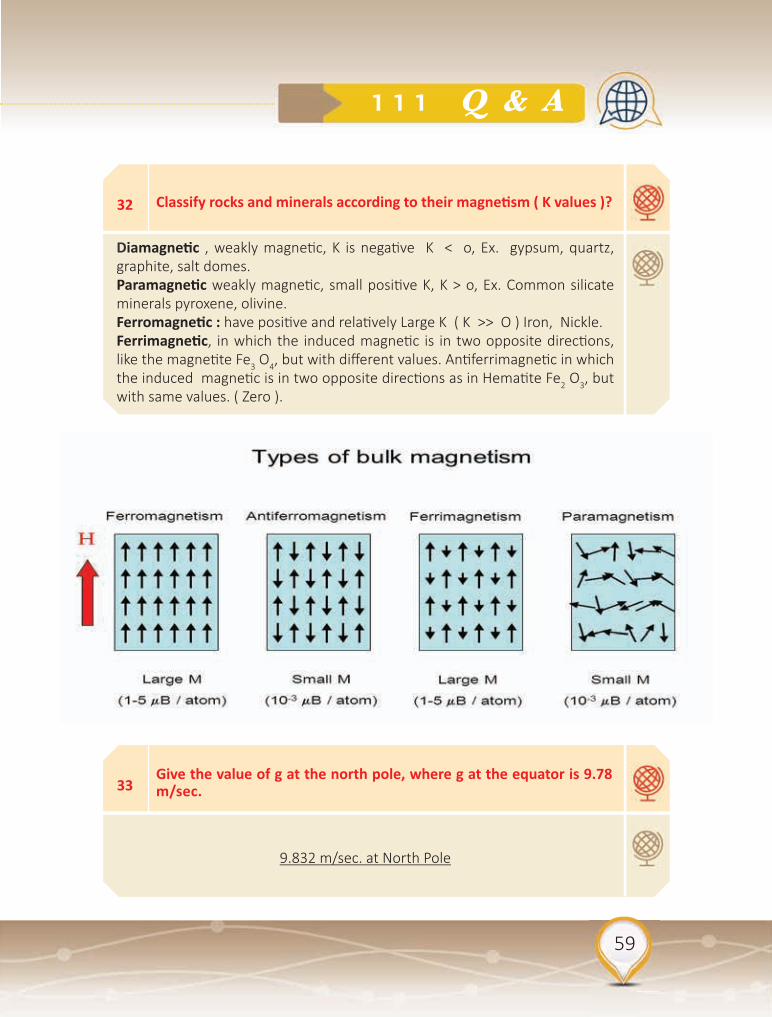
Diamagnetic , weakly magnetic, K is negative K < o, Ex. gypsum, quartz, graphite, salt domes.Paramagnetic weakly magnetic, small positive K, K > o, Ex. Common silicate minerals pyroxene, olivine.Ferromagnetic : have positive and relatively Large K ( K >> O ) Iron, Nickle. Ferrimagnetic, in which the induced magnetic is in two opposite directions, like the magnetite Fe3 O4, but with different values. Antiferrimagnetic in which the induced magnetic is in two opposite directions as in Hematite Fe2 O3, but with same values. ( Zero ).
33Give the value of g at the north pole, where g at the equator is 9.78 m/sec.
9.832 m/sec. at North Pole

60
Questions & Answers in Gravity
34If you took a gravimeter 1 km down a mine in rocks of density 2.3 mg/m , gravity would change by :
212
35
36
37
38
Calculate the average density of the Earth, given that g is 9.81 m/sec, and the average Earth radius is 6371km . How does this compare with the density of granite?
Compared to the Earth , the mass of the moon is about 1/80 and its radius a quarter . How does its surface gravity compare ?
The value of g at a place A is less than that at B. Which of the following might be the explanation ?
What is the difference in gravity and magnetic fields as far as a mea-surement approach?
5.5 about twice.
A fifth.
A. is at a higher elevation.B. is underlain by lower-density rocks.
Fields changing as a function of radius, latitude, time; Since you remove the main field, the anomaly for the same object in a gravity survey will be the same wherever you are on the Earth. For Magnetic surveys, anomaly will be different at different locations.

61
111 Q & A
39
40
41
What does gravity and magnetics produce as far as models go?
Is gravity a passive or active source and why?
Is magnetics a passive or active source and why?
Gravity almost always make a 2d x–sectional model or maps of basins, whereas magnetics make contour maps of magnetic intensity.
Gravity is a passive source: because– gravitational acceleration results from attraction between two point mass’s; small mass on our gravimeter is attracted to the main mass (mass of the Earth; gravity field changes spatially on the surface of the Earth; Use latitude correction to account for this; gravity at poles is greater than equator as a result of radius. Acceleration at poles is greater than at equators for 3 reasons but changes nicely as a function of latitude; Temporal changes in the gravity field from tides related to the moon
Magnetics is passive. because– changes spatially on the surface of the Earth; International Geomagnetic Reference Field (IGRF) has worldwide stations to calculate a reference field which you subtract out to get rid of main field; Changes temporally.

62
Questions & Answers in Gravity
42
43
A gravity reading is taken in a stationary helicopter hovering 1 km above mean-sea level at a particular location. The difference in the value of g measured in the helicopter and at mean sea level vertically beneath the helicopter is ?
The angle of inclination of the remnant magnetization measured on a basalt flow at a location P (28o N 85o E) is 40o. The palaeomagnetic latitude of the basalt flow is?
300 to 320 (or) - 320 to - 300 mGals.
22.5 to 23o N.
44 If you wished to identify the magnetic mineral in a rock, would it be more useful to measure its curie or blocking temperature ?
Curie temperature.
45A rock magnetized when it was 20 S of the equator has dri�ed to 20 today . its inclination differs from that of its present position by :
72

63
111 Q & A
46
47
48
The field at the equator, compared to the that at the pole, is :
The magnetic field one Earth radius above the north pole compared to the field at the pole is :
How is the aeromagnetic map of a sedimentary basin likely to differ from that over old crystalline basement rocks ?
Half.
An eighth .
The basement rocks are likely to produce anomalies that are shorter in wavelength and larger in amplitude than those over the basin.

64
Questions & Answers in Gravity
49Assume a spherical homogeneous earth having a density of ρ = 5.5 g/km3 and R = 6371 km, The earth mass M = 4/3 R3 ρ .

65
111 Q & A
50What is the gravitational potent ial energy of 1 - kg mass at the earth’s equator?
(a) If this mass fell toward the earth from a large distance, where it had zero relative velocity, what would be the velocity at the earth’s surface?
[a] By definition, the gravitational potential energy per unit mass of an object brought from infinity (where its potential energy = 0).So we need only com-pute V at r = a, ϕ = 0

66
Questions & Answers in Gravity
52Given same as above in problem 51 . Except elevation of station 100 m below sea level. Compute : Free air anomaly & Bouguer gravity anomaly
ΔgF = 980306.19 - 980302.12 + (0.3086 X - 100) = - 26.79 mGal
ΔgB = 980306.19 - 980302.12 + (0.3086 X - 100) - (0.0419 X 2.0 X
- 100) + 0.15 = - 18. 26 mGal
51 Given : Observed gravity at base 980.30045 Gals
Observed gravity at station relative to base + 5.65 mGal, Theoretical gravity at sea level at latitude of station 980.30212 Gals ;Elevation of station 100 m above sea level
Density of rock above sea level 2.0 g/cc; Terrain effect 0.15 mGals. Compute 1. Bouguer gravity anomaly 2. Free air anomaly
67
111 Q & A
53Given : Observed gravity relative to base + 30 mGal Elevation of sta-tion 150m above base station is 1000 m north of base; Latitude effect is 0.00025 mGal/m ;Density is 1.8 g/cc. , Terrain effect is 0.05 mGal
Compute: Free-air and Bouguer anomalies:ΔgF = Δgobs - gϕ + CF ΔgF = 30 - (0.00025 X 1000) + (0.3086 X 150)ΔgF = 30 - 0.25 + 46.29 = ΔgF = 76.04 mGal
= 76.04 - (0.0419 x J.8 x 150) + 0.05= 76.04 - 11.313 + 0.05 = ΔgB = 64.777 mGal
54
Given : Observed gravity relative to base - 12.5 mGal , Elevation of station is 100m below the base, Station is 2000 m south of base, Lat-itude effect is 0.00025 m Gal/m , Density is 1.8 g / cc. Terrain effect is 0.1 mGal. Compute: Free air anomaly and Bouguer gravity anomaly.
= - 12.5 - (0.00025 x - 2000) + (0.3086 x - 100)
= - 12.5 + 0.5 - 30.86 = - 42.86 mGal
ΔgB = - 42.86 - (0.0419 X 1.8 X - 100) + 0.1
ΔgB = - 42.86 + 7.542 + 0.1 ΔgB = - 35.218 mGal

68
Questions & Answers in Gravity
55
56
57
In a gravity survey, what observations must you acquire to be able to carry out a dri� correction?
In a gravity survey, what observations do you have to acquire in order to be able to carry out the Bouguer correction?
What is the Newton’s Law of Gravitation:
Several Δg readings at same (base) station and the times they were made
Near-surface density and elevation (thickness of layer above reference level)
F = G m1 m2 / r2 Newtons.F = force acting between two point massesm1, m2 = the massesr = separation of the two massesG = Universal gravitational constant = 6.67 x 10⁻¹¹ Nm2kg-2

69
111 Q & A
58 What is the mean density of the earth ? How is it determined ?
Newton also found that on Earth:
F = m.g; Where m is a bodies mass, and g is the acceleration due to gravity. But a body of mass m is attracted to the Earth by gravity, with a force:
F = G mM/ R2 where M is the mass of the Earth, and R is its radius (~6400 km), m.g= G.m.M/ R2 ; g = G.M / R2 .
The units of g are Newton.kg-1 (force per unit mass) or (more commonly), m.s-
2 (acceleration).
Numerically, these are identical and: g ~9.81 ms-2 .
In fact g can be obtained from the period of a pendulum, and so the equation: g = G.M / R2
is used to determine: M = 5.9742 x 1024 kilograms
Geologically, the density of earth is very important. If ρ is the average density of the Earth,
Then ρ = mass/volume = M / [(4/3)πR3] = 3M / 4πR3 , We can substitute for M using the relationship between it and g, i.e. M = R2g / G., Therefore: ρ = 3g / 4πRG . Thus if we know g, R and G, we can calculate ρ. With current values:- ρ = 5.52 x 10³ kgm-3
Since most surface rocks have densities in the range 2-3 x 10³kg.m-3, density must increase with depth in Earth. This has also been confirmed by seismology, since seismic velocities, which are strongly correlated with density, increase with depth.

70
Questions & Answers in Gravity
59If the density of the Earth increases by 20% and the radius decreases by 20%, then what will be the new value of gravity on the surface of the Earth?
The universal law of gravitation states that gravitational force, F = (GMm)/(R2), Now, think of this earth as a big ball with mass in it. thus the mass of earth M = p.(4/3).π.(R3).where p is the density of earth and R is the radius of the earth.Now the new p’ = 1.2(p) as the density is increased by 20%, R’ = 0.8(R) as the radius is decreased by 20%, the new mass M’ = p’. (4/3) .π. (R’3) = (1.2) .(0.83) .p. (4/3) .π. (R3)(M’/M) = (1.2).(0.83). the new gravitational force is F’ = (GM’m)/(R’2)(F’/F) = (M’.(R2))/(M.(R’2)) = (M’/M).((R/R’)2) = (1.2).(0.83).(1/(0.82))= (1.2).(0.8) = 0.96 . It means the new gravitational force is 0.96 times the original Force of gravity. Thus the new value of g’ is 0.96 times the original g. thus the new g’ is 9.408 m/(s2)

71
111 Q & A
60 What is the shape of the Earth ?
The Earth is not spherical, but an ELLIPSOID OF REVOLUTION i.e. it is flattened at the Poles - this is a rotational effect. equatorial radius = 6378 km., polar radius = 6356.6 km.Fla�ening = (6378 - 6356.6 ) � 6378 = 1 � 298.26. Now since g = GM � R2, g will be larger where R is smaller. Therefore g at the poles is larger than g at the Equator. g is also affected by the fact that the Earth rotates and an observer on its surface therefore experiences a centrifugal force. We can summarize by saying: (1) If the Earth were a non-rotating perfect sphere, the acceleration due to gravity would be constant. (2) Because of rotation, the Earth is flattened at poles. This affects g in two ways: (a) g at the poles is greater than g at the equator because R at the poles is less than R at the equator. (b) rotational force at the Earth surface is at right angles to the axis of rotation and proportional to the distance from that axis. It is therefore zero at the poles and a maximum at the Equator. It acts outwards, reducing g.

72
Questions & Answers in Gravity
61 What is the IGF ?
The gravitational acceleration on the surface of the spheroid is given by the International Gravity Formula (IGF). g = 9.780318 (1 + a sin2(λ) - b sin2 (2λ)) , where g = sea-level gravitational acceleration on the spheroid and λ = latitude, anda = 0.0053024 and b = 0.00000587 .g at Equator (lat = 0) = 9.780318 m.s-2
g at Pole (lat = 90) = 9.832177 m.s-2
62 What is the Geoid ?
The real sea level equipotential surface is known as the GEOID and has “highs” and “lows” relative to the spheroid. Contours of the geoid give the height, above or below the spheroid, by which sea level actually varies over the Earth’s surface. The geoid map may be divided into large positive and negative regions (above and below spheroid surface). Most positive features correspond to active magmatic regions e.g. Mid-Atlantic Ridge, Negative features are centered over old, inactive ocean basins and continents. e.g. Antarctica.

73
111 Q & A
63 Define Crustal Gravity Anomalies ?
There are smaller scale effects because of crustal inhomogeneities (sedimentary basins, intrusions, etc.). In a gravity survey we measure the difference in gravity between survey points (S) and a reference station (P), using a gravity meter. Ideally P is either an international gravity reference station or has been linked to such a station by gravity measurements. Inevitably, the differences will be small and the m.s-2 is far too large a unit. Gravity anomalies are therefore measured in GRAVITY UNITS. 1 g.u. = 10-6 m.s-2

74
Questions & Answers in Gravity
64 Describe data corrections required in gravity surveying ?
Once the value has been obtained it must be CORRECTED to account for effects such as:- (1) Latitude differences. (2) Elevation effects. (3) Topographic effects,
Latitude Correction. For small N-S distances (up to a few km) the difference in gravity due to latitude at latitude λ is approximately:- ΔgLAT = 8.1 sin(2 λ) g.u. per km .
Free-air Correction. If stations are at different elevations, we would expect gravity to be different because of the different distances to the center of the Earth. The effect for a positive height (h) above sea-level is approximately equal to 3.086 g.u./metre , an increase in height produces a decrease in gravity. ΔgELEV = -3.086h g.u. If the gravity anomaly is to be measured to within 0.1 g.u., the station elevation (h) must be known to within 3 cm!
Bouguer Correction. The free-air correction assumes that only air exists between the station and the reference surface. In reality, a normal gravity station on land will be underlain by rock, which exerts a positive (downwards) gravitational pull. The Bouguer correction uses a simple approximation for the effect of this rock column. We assume that the gravity effect of the real topography can be approximated by the effect of a uniform flat plate, density ρ (in kg m-3) and thickness h, extending to infinity. This effect is given by:-
ΔgBOUGUER = 2π G ρ h = 41.91 x 10⁻⁵ρ h g.u. The effect is positive (ie it increases the gravity field).
Terrain Correction. Although the Bouguer correction works surprisingly well, it is inadequate for high precision surveys or for surveys carried out in topographically rugged areas. If the station is next to a mountain or valley, the mass difference of the topographic feature from The Bouguer plate will affect the measured gravity field. Thus the terrain correction must be added to give corrected gravity differences. The combination of terrain and Bouguer corrections is call the TOPOGRAPHIC correction.

75
111 Q & A
65 Describe Gravity anomalies?
Once all the corrections have been made, the REDUCED gravity records variations in gravity field due solely to subsurface density variations.
If only the latitude and free-air corrections have been applied, the quantity calculated is known as the FREE-AIR GRAVITY (free-air anomaly). If, the Bouguer correction has been applied, the quantity is known as the (SIMPLE) BOUGUER GRAVITY (or anomaly). If, IN ADDITION, terrain corrections have been made, the quantity is known as the EXTENDED BOUGUER GRAVITY or COMPLETE BOUGUER GRAVITY (or anomaly). A gravity survey across a mountain range will show a negative Bouguer gravity, because mountains have low density roots.
Bouguer Gravity Anomalies

76
Questions & Answers in Gravity
66
IF THE MAGNETIC SUSCEPTIBILITY OF A SPHERICAL PLUTON IS 0.0003 AND HE EARTH’S MAGNETIC FIELD ( B ) IS 0.0006 TESLA. THE RADIUS OF THE PLUTON IS 1 KM AND THE MAGNETIC PERMEABILITY IS 4 π X 10 -7. COMPUTE :1. THE MAGNETIC FIELD STRENGTH ( H ),2. THE INTENSITY OF MAGNETIZATION ( I ) ,3. THE MAGNETIC MOMENT OF THE PLUTON ( M ).
1. H = B / U = 0.0006 / 4 x 3.14 x 10 -7 = 477.72. I = K H = 477.7 x 0.0003 = 0.1433. M = I V = 0.143 x 4/3 (3.14) r 3 = 0.599
67
GIVEN THE FOLLOWING INFORMATION : MOUNTAIN HEIGHT ( h ) = 2 KMSEA HEIGHT ( h ) = 1.5 KM; DENSITY OF THE EARTH ( P ) = 2.6 g / ccDENSITY OF ANTIROOT ( P\ ) = 3.3 g / cc , DENSITY OF WATER = 1.03 g / cc THICKNESS OF THE EARTH ( T ) = 30 KM. COMPUTE :
A. THICKNESS OF ROOTS BELOW MOUNTAINS ( t )B. THICKNESS OF ANTIROOT BELOW THE SEA ( t\ )C. DEPTH OF COMPENSATION IN THE MOUNTAIN ( Tc )D. DEPTH OF COMPENSATION IN THE SEA ( Ts )
A. t = 2.6 x 2 / 3.3 -2.6 = 7.43 km.B. t\ = ( 2.6 – 1.03 )1.5 / 3.3 – 2.6 = 3.36 km.C. Tc = T + h + t = 30 + 2 + 7.43 = 39.43 km. D. Ts = T - t\ - h\ = 30 – 3.36 – 1.5 = 25.14 km.

77
111 Q & A
68What is the difference between Forward and inverse problems in Gravity?
Geophysical data interpretation can be divided into two types of problems:1) Forward problems – a known subsurface structure is used to calculate what would be observed using geophysical techniques. Type equation here.
For gravity: Density model for Earth predicted gravity data. This is good for understanding the geophysical response of simple structures and for determining if a survey would be able to detect a particular structure.2) Inverse problems – observed geophysical data is used to determine the subsurface structure. For gravity: Measured gravity data density model for Earth. This is the most common situation in geophysics and can often lead to non-unique interpretations – more than one Earth model can explain the observations.
69 Discuss the concept of Absolute and Relative gravity?
Absolute gravity. This technique makes measurements of the total gravity field at a site. There are a number of types of instruments, including free-fall devices, the reversible pendulum, and superconducting gravimeters. The equipment is very expensive and bulky. Lengthy observation times (24+ hrs) are required to obtain accurate readings (0.001-0.01 mgal).
Relative gravity. In general, for interpreting gravity data, only the relative gravitational acceleration is required. Therefore, we usually don’t need to know the absolute gravity at every station, just how gravity changes between stations. The relative gravity readings can be converted into absolute gravity if one of the survey sites is chosen to be a place where the absolute gravity was measured previously.

78
Questions & Answers in Gravity
70
71
How to carry out Marine gravity surveys?
How to conduct Satellite gravity surveys?
Marine gravity surveys can be measured in two ways: 1. Lowering a gravimeter (usually LaCoste-Romberg type) to the seafloor in a waterproof container. The gravimeter is leveled and the gravity reading is sent digitally to the ship. This is time-consuming because the ship must stop moving in order to lower the instrument. The typical accuracy is 0.1 mgal. 2. Using a gravimeter on board a moving ship. The velocity of the ship affects gravity measurements and is accounted for by the Eötvös correction (correction for Earth’s rotation). Also, waves can result in accelerations of 100,000 mgal or more. The gravimeter is placed on a gyroscopically stabilized pla�orm to keep the gravimeter level. Vertical motions can be corrected by averaging measurements over several minutes. Accuracy is generally 0.5 to 1 mgal.
A satellite orbiting the Earth is in free fall - accelerating toward the Earth due to gravity and therefore gravitational acceleration can not be directly measured. However, detailed observations of the satellite orbit (using two satellites) or accurate measurements of the satellite altitude can be used.GRACE mission: http://www.csr.utexas.edu/graceGOCE mission: http://www.esa.int/esaLP/LPgoce.html

79
111 Q & A
72
73
What is meant by Regional and residual anomalies in Gravity ?
How to utilize gravity in Hydrocarbon exploration ?
Maps or profiles of Bouguer gravity contain information at a range of spatial scales, from a few m to 100’s of km (see Alberta map). The data can be divided into:• Regional anomalies – broad features of regional extent. These have a long spatial wavelength (large x1/2) and are generally associated with deep structures.• Local anomalies (or residual anomalies) – local features with a short wavelength (small x1/2). There result from shallow structures, such as salt domes, ore bodies, and near surface faults.• the distinction between regional and local is somewhat arbitrary. In exploration work, we are mostly interested in understanding the local (shallow) subsurface structure. Long wavelength anomalies tend to obscure the local anomalies, making them difficult to analyze. Thus, it is desirable to remove the regional anomalies.
Gravity data can be used to map the thickness and extent of sedimentary basins. Due to their low density, sedimentary basins generally appear as gravity lows. Gravity data can also provide information on the detailed structure of the sedimentary basins – e.g., basement faults, reefs and other structures. Satellite gravity data has become an important tool for offshore exploration. Gravity surveying is also used for mapping the distribution and geometry of salt structures in sediments. As salt has a lower density than sediments, salt structures will appear as a negative gravity anomaly. The upward movement of buoyant salt through sedimentary layers is important for the formation of petroleum reservoirs. Seismic data can be used to identify the top of salt layers and domes, but the deeper structure is not as clear. Gravity data can be used to better determine the geometry of salt structures.

80
Questions & Answers in Gravity
74
75
How to apply gravity in Mineral exploration?
What is the Origin of surface geomagnetic field?
Ore bodies often have a higher density than the surrounding rock and therefore can produce a positive gravity anomaly. The excess mass of the ore body can be calculated using Gauss’s theorem but the geometry can not be uniquely determined. Gravity data has also been used to identify kimberlites, which can appear as gravity lows with a nearly circular shape.
The magnetic field observed at the Earth’s surface (BE) is made up of three components:(1) The geodynamo (97% of BE) – originates within the Earth’s outer core from flow of liquid iron. Buoyancy-driven convection and Coriolis forces (caused by Earth’s rotation) result in helical flow patterns. This can explain the main features of the geomagnetic field, including the approximate alignment of the dipole with the rotation axis and periodic reversals of the magnetic field. Note: The Earth is not a bar magnet. The magnetic field must be actively generated by outer core flow – the temperatures are too high to have remnant magnetization. (2) external sources (1-2% of BE) – interactions between the Earth’s atmosphere and the solar wind (a stream of electrons, protons, and H and He ions from the Sun) in the magnetosphere. (3) crustal magnetism (1-2% of BE) - induced magnetization and remnant magnetization of crustal rocks (at temperatures below the Curie temperature). This is the component that we are interested in for magnetic exploration

81
111 Q & A
76 What is the importance of Remanant Magnetization?
Many ferromagnetic and ferrimagnetic materials will remain magnetized after the applied magnetic field is removed. This is called remnant magnetization. The magnetic susceptibility of paramagnetic materials depends on temperature. Magnetic susceptibility will decrease with increasing temperature. Above a critical temperature (the Curie temperature, Tc), it is not possible to produce induced magnetization. Some Curie temperatures: magnetite (Fe3O4) TC = 578°C pure iron (Fe) TC = 770°C cobalt (Co) TC = 1121°C. thermoremanent magnetization (TRM): when rocks form at high temperatures and cool below the Curie temperature of the magnetic minerals, the direction of the surrounding magnetic field at the time of cooling will be locked into the rock (unless the rock is heated above the Curie temperature, e.g., due to metamorphism). Rocks with magnetic minerals can possess both induced (Mi) and remnant magnetization (Mr). This is expressed in terms of the Königsberger ratio: Q = Mr/Mi Sedimentary rocks Q ~ 0.01 Metamorphic rocks Q ~ 0.1 Granites Q ~ 1.0 Basalt/gabbro Q ~ 10.0

82
Questions & Answers in Gravity
77
78
79
What is Microgravity and its Applications?
What Physical property of the subsurface is the gravity method sen-sitive to?
What are the range of values for gravity measurements?
Microgravity surveys are used to identify lateral variations in the subsurface soil and rock density, which are influenced substantially by the size and depth of the target. Microgravity surveying (Gravity) is a valuable tool to characterize subsurface karst features. Gravity can map and identify preferential flow paths associated with fractures zones and large cavity systems. It can also be used for the identification and characterization of potential collapse features due to karst sinkhole activity or mine subsidence. Microgravity can be applied in :
• Karst related cavities and solution channels• Void Identification• Sinkhole Delineation• Mine Subsidence Mapping• Buried Valley Identification
Density contrasts (Δρ).
1.8 – 3.0 g/cc

83
111 Q & A
82 What processing steps need to be done in order to use gravity data?
Drift Correction; Tie to Absolute Base; Latitude; FA ; BC ; Terrain
83 Why are density variations significant in gravity measurements?
Density varies in the subsurface, therefore, so does gravitational acceleration. Sediments are less dense than basalts. Voids are easy to find because of the huge density contrast.
80What processes on Earth cause variations in this property in the subsur-face?
Tides and large bodies
81 Where is the gravity method commonly used?
Useful for complex bodies; Basins, cavities, salt–domes, faults

84
Questions & Answers in Gravity
85If we want to know our gravity anomaly to a precision of 0.1mGals how well must we know our vertical position?
Need to use GPS to get within 10cm
86 What is the universal gravitational constant?
G=6.67×10⁻¹¹ Nm2kg
84 Why do we tie to a base station when taking gravity measurements?
Absolute gravimeters must are large and difficult to calibrate so we use Relative gravimeters and tie to these Absolute Base Stations. Must tie to the absolute base station at the beginning and at the end to close the loop. Must return to absolute base station often enough to assume a linear relationship. The mass and bulk of the Earth change over the day because of tides, so should tie in every hour.

85
111 Q & A
87The units used in describing the gravitational acceleration variations are
A. Milligal C. gammaB. nanoTesla D. gram/cc
88Correction accounts for the excess mass underlying observation points located at elevations higher than the elevation datum.
A. Free Air C. TerrainB. Bouguer D. Latitude
89 Which one of the following is not true ?
The value of g varies over the surface of the earth Longitude.

86
Questions & Answers in Gravity
90The effect of small scale near surface inhomogeneities can be re-moved from magnetic data by
A. upward continuation C. second vertical derivative.B. downward continuation. D. reduction to pole.
91
92
93
Which one of the following corrections is always added during reduc-tion of the observed gravity data?
If you apply the free-air correction in a gravity survey, what does it correct for?
Name two different geological features or structures or rock types that you might be able to map by carrying out a magnetic survey.
A. Latitude C. BouguerB. Free-air D. Terrain
Elevation (only).
Basement structure; igneous intrusive; salt; metallic ore bodies; rocks rich in magnetite; etc.

87
111 Q & A
94Why does the moon’s gravity cause tides on earth but the sun’s grav-ity doesn’t?
The ocean tides on earth are caused by both the moon’s gravity and the sun’s gravity. In general, ocean tides are not generated by the overall strength of gravity, but instead by the differences in gravity from one spot to the next (the gravitational gradient). Even though the sun is much more massive and therefore has stronger overall gravity than the moon, the moon is closer to the earth so that its gravitational gradient is stronger than that of the sun. Because ocean tides are the effect of ocean water responding to a gravitational gradient, the moon plays a larger role in creating tides than does the sun. But the sun’s gravitational gradient across the earth is significant and it does contribute to tides as well.

88
Questions & Answers in Gravity
95 Why does the Earth rotate? Why doesn’t it stop?
Planets do not have to rotate. Look at Venus. It rotates so slowly that it might as well not be rotating. It rotates backward as well. You might think of it as negative rotation. Therefore, zero rotation is an option for any planet. Most planets do rotate and rotate in a forward (same direction as revolution) direction. This is all due to conservation of angular momentum. However, the chaos of planet formation can result in a different rotation, even near to zero. Why doesn’t it stop?The Earth and its rotational speed is decreasing ever so slowly from factors such as the Moon capturing some of its angular momentum and the solar wind creating friction. The exact length of a day 4 billion years ago is not known, but estimates peg it to around one-quarter of today’s day. In another 4 billion years, it may be twice as long — again, we cannot figure it out exactly due to too many unknown future factors being involved. It will stop when the Sun swallows it up in 4–5 billion years.

89
111 Q & A
96 Discuss the two assumptions of Isostacy?
1. Pra� measured deflection of plumb line towards the Himalayas.Higher the mountain, smaller the mean density.Crust extends to a uniform depth below sea-level.This is the compensation depth.All crustal columns have the same mass above the compensation depth.Height, h, of crustal topography (above sea-level) is related to its density2.Airy’s Mountain underlain by a root of light material. Higher the mountain, deeper the root

90
Questions & Answers in Gravity
97 What are Curie and Neel Temperatures?
The spontaneous magnetisation of ferromagnetic and ferrimagnetic substances decreases with increasing temperature and disappears at the Curie Temperature Tc. eg Magnetite Tc = 580°C, Iron Tc = 770°C.
Néel Temperature: In antiferromagnetic substances, this is the temperature when the substance becomes paramagnetic. eg Hematite Tc = 670°C.
98 What is Hysteresis?
Hysteresis is a characteristic of all ferromagnetics

91
111 Q & A
99
100
101
102
Who Discovered The Three Well Known Laws Of Planetary Motion Which Led To The Discovery Of The Universal Law Of Gravitation ?
Why Is Gravitational Force The Most Important Force ? Is It A Strong Force Or Weak Force ?
What Are The Various Factors Which Affect The Value Of Acceleration Due To Gravity ?
What Is An Equipotential Surface ?
Johnannes Kepler.
Gravitational is one of the four fundamental forces of nature. This effect our actions in every day life such as walking, jumping, throwing a ball and so on. Also it is responsible for a initiating the birth of stars, for controlling the entire structure of the universe and evolution of the universe. Thus we find that gravitational force is the most important force. In fact it is the weakest force among the four fundamental forces of nature.
The value of acceleration due to gravity at a place is affected by the following factors: Latitude of the plane, Altitude height from the earth’s surface, Depth.
A surface, at all points of which the gravitational potential is the same is called, an equipotential surface. No work is done against the gravitational force in moving a unit, ( or any other mass ) mass from one point to another on an equipotential surface, because difference of potential between any two point is zero.

92
Questions & Answers in Gravity
103
104
105
106
What Is Orbital Velocity ?
What Are The Three Kelper’s Laws of Planetary Motion ?
What Is The Importance Of Law Of Gravitation As Applied To The Plan-ets ?
The Gravitational Potential Energy Of Two Masses Separated By A Fi-nite Distance?
The velocity which is given to an artificial earth’s satellite a few hundred kilometers above the earth’s surface so that it may start revolving round the earth is called orbital velocity.
The three laws of kepler’s regarding planetary motion are Laws of orbits, Law of areas Law of periods.The Law Of Orbits states that the motion of a planet is an ellipse with the sun at one focus. ( The other focus has no significance ).The Law Of Areas states that the line joining the planet to the sun sweeps out equal areas in equal times. The Law Of Periods states that the square of the period of any planet about the sun is proportional to the cube of the planets mean distance from the sun.
The law of gravitation can be applied to Find the force exerts by planets on other bodies and to determine the motion of the planets around the sun.
It is always positive

93
111 Q & A
107
108
109
Which Famous Experiment Was Conducted By Gaileo At The Leaning Tower Of Pisa ?
Under Which Condition Do A Feather And A Piece Of Iron Fall At The Same Rate ?
What Is Gravitational Wave ?
The experiment to prove that both heavy and light bodies take the same time to fall down the earth.
In vacuum
A gravitational wave is a fluctuation in the curvature of space time which propagates as a wave, travelling outward from the source. Predicated by Einstein’s theory of general relativity, the waves transport energy known as gravitational radiation.

94
Questions & Answers in Gravity
110
111
What Is Gravitational Intensity ?
What Are The Four Fundamental Forces Of The Nature ?
The force experienced per unit mass placed at the point in the gravitational field is called intensity of the gravitational field.
Gravity, electromagnetic force, strong force and weak nuclear force.

Questions & Answers
inExploration Seismology
989898989898989898989898

96
Exploration Seismology Methods

97
98 Q & A
Seismic surveys are essential for understanding the geology of sedimentary basins for hydrocarbons. The tests involve generation of seismic (elastic) waves which propagate into the ground and recording their return to the surface using seismic vibrators, that generate small vibrations in the ground. As seismic wave travels deep into the Earth, it is reflected by rock boundaries which display different density and elastic wave propagation velocity. Seismic wave is refracted and partly deflected at the boundary, and then travels back to the ground surface. 2D and 3D seismic surveys are most often used in shale gas exploration. A 2D seismic profile represents a “slice” of the earth and provides an image of the structure solely along the seismic line, while 3D seismic provides a three-dimensional set of seismic data. 4D seismic involves a comparison of seismic data that have been acquired in the same area at specific time intervals. 4D models provide an insight into the changes that have occurred in the rock formation.

98
Exploration Seismology Methods
1 Define all types of Stresses ?
Stress, defined as force per unit area, is a measure of the intensity of the total internal forces acting within a body across imaginary internal surfaces, as a reaction to external applied forces and body forces. It was introduced into the theory of elasticity by Cauchy around 1822.
Tensile stress: - If there is an increase in the length or extension of the body in the direction of the body in the direction of force applied.
Compression stress: - If there is decrease in length of the wire or compression of the body due to force applied.
Tangential stress: - When a deforming force, acting tangentially to the surface of a body produces a change in the shape of the body .
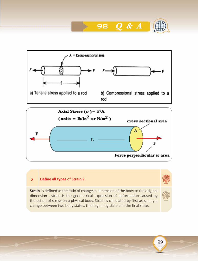
99
98 Q & A
2 Define all types of Strain ?
Strain is defined as the ratio of change in dimension of the body to the original dimension . strain is the geometrical expression of deformation caused by the action of stress on a physical body. Strain is calculated by first assuming a change between two body states: the beginning state and the final state.

100
Exploration Seismology Methods
Longitudinal Strain:-It is defined as the increase in length (L) per unit original length (l) when deformed by the external force. Longitudinal Strain= L/ l
Volumetric Strain:-It is defined as change in volume (V) per unit original volume (v), when deformed by external force. Volume Strain= V/ v
Shear Strain:-When change takes place in the shape of the body, the strain is called shear strain.

101
98 Q & A
3 Define Hooke’s Law and related Elastic Modulus ?
Hooke’s Law states that the extension produced in a wire is directly proportional to the load attached to it. i.e. Stress=E*Strain (where E is constant called modulus of Elasticity or coeffient of elasticity.)
Modulus of Elasticity is defined as ratio of Stress to the corresponding Strain within the proper elastic limit. Its unit is n/m . There are three types of modulus of elasticity. E = Stress / Strain
Young’s Modulus
the description of the elastic properties of linear objects like wires, rods, columns which are either stretched or compressed, a convenient parameter is the ratio of the stress to the strain, a parameter called the Young’s modulus of the material. Young’s modulus can be used to predict the elongation or compression of an object as long as the stress is less than the yield strength of the material.
Young’s Modulus: E = μ (3 + 2 μ ) ÷ ( + μ )
= first Lamé coefficient (no direct physical interpretation)

102
Exploration Seismology Methods
Bulk Modulus. The bulk elastic properties of a material determine how much it will compress under a given amount of external pressure. The ratio of the change in pressure to the fractional volume compression is called the bulk modulus of the material. K = + 2/3 μ
Modulus of rigidity. It is defined as the ratio of tangential stress to shear strain . It is also called shear modulus . It is denoted by the Greek letter eta (ή) .
4 What is Poisson’s Ratio ?
It is the ratio of lateral strain per unit longitudinal strain. It is denoted by σ . It is unit less and dimensionless quantity. Its value is in between 0 to 0.5 Poisson’s Ratio: s = / 2 ( + μ) Poisson solid: material for which = μ , giving s = 0.25

103
98 Q & A
5 Briefly, derive elements of Theory of Elasticity ?
Infinitesimal strain tensor has elements (e) that are linear functions of spatial derivatives of displacement components (u):
Stress and strain are related by Hooke’s law:(cijkl are elastic constants)
Stress tensor has 9 elements ( τ11 ... τ33), and consists of normal (τ11, τ22, τ33) and shear stress components. τij is stress that acts on the small surface with the normal along i-th coordinate, and the force component is directed in the j-th direction:

104
Exploration Seismology Methods
6
7
What is Navier equation of motion ?
Express Wave equation in terms of Body Waves ?
Assuming the anisotropic body, so that of all elastic constants cijkl only two remain and are denoted as λ and μ. They are called Lamé’s constants. This is rather complicated 3-D partial differential equation describing displacements within the elastic body
In these expressions α and β are velocities of longitudinal and transversal waves. We see that they only depend on the properties of material through which they propagate.

105
98 Q & A
8 What is a seismic wavefront
Surface of constant phase, like ripples on a pond, but in three dimensions
9 What is a ray
Also referred to as a “wavefront normal” a ray is an arrow perpendicular to the wave front,

106
Exploration Seismology Methods
11 What if V2 < V1?
If V1>V2, then as i increases, r increases, but not as fast. If V2<V1, the energy refracts toward the normal. None of the refracted energy makes it back to the surface. This is called a velocity inversion
10 What is the Critical refraction
At Critical Angle of incidence ic, angle of refraction r = 90o
Seismic refraction makes use of critically refracted, first-arrival energy only. The rest of the wave form is ignored.

107
98 Q & A
12 What is Huygen’s principle ?
Every point on a wavefront can be considered a secondary source of spherical waves, and the position of the wavefront after a given time is the envelope of these secondary wavefronts. Treat all the points on a wavefront as point sources that generate secondary spherical wavefronts (‘wavelets’). Given the geometry of a wavefront at time t1, the principle can be used to construct the geometry of the wavefront at a later time t2. Useful for understanding reflection, refraction and diffraction of seismic waves

108
Exploration Seismology Methods
13
14
15
Why P-wave velocity must always be greater than s-wave velocity?
Define Fermat’s principle?
What is Snell’s Law?
K and μ are always positive numbers, so Vp is always greater than Vs.
In 1650, Fermat discovered a way to explain reflection and refraction as the consequence of one single principle. It is called the principle of least time or Fermat’s principle. Fermat’s principle states that of all the possible paths the light might take, that satisfy those boundary conditions, light takes the path which requires the least amount of time.
A wave incident on a boundary separating two media is reflected back into the first medium and some of the energy is transmitted, or refracted, into the second. The geometry of refraction and reflection is governed by Snell’s Law which relates the angles of incidence, reflection and refraction to the velocities of the medium. The cartoon below illustrates the ray geometry for a P-wave incident on the boundary between media of velocity V1 and V2. The angles of incidence, reflection and refraction, θ1,θ1’, and θ2, respectively are the angles the ray makes with the normal to the interface.

109
98 Q & A
16 What is the seismic wave equation?
Combine Newtons Second Law of Motion with description of material deformation (constitutive equations for elastic isotropic materials with two parameters lambda and mu).

110
Exploration Seismology Methods
17 What is the fundamentals of seismic refraction and reflection?
The aim of seismic exploration is to map geological structures to aid in finding hydrocarbon and mineral resources, as well as environmental and engineering investigations. Exploration Seismology works with: (1) Artificially generated “seismic sources” (2) High frequency range of about 10 -100 Hz (3) Specific geometries of deploying seismic sources (shots) and receivers.
Reflection occurs when a wave is incident on a boundary between two media in which the wave speed is different, and then remains in the original medium rather than passing into the second medium. While reflection occurs at any boundary, often only a small proportion of the wave is reflected.
Refraction is the change of the direction of propagation of waves when they pass into a medium where they have a different speed. It is observed whenever the waves are incident to the surface at an angle different to the normal to the surface. When moving from a medium where they move faster to one where they move slower, the wave direction is brought closer to the normal, following Snell’s Law.

111
98 Q & A
18 Define Reflection and Transmission Coefficients ?
The reflection co-efficient ( AR ) is the ratio of the amplitudes of the reflected and incident waves. Similarly, the transmission co-efficient ( AT ) is the ratio of the amplitudes of the transmitted and incident waves: The amount of energy that is partitioned into transmission and reflection depend on the angle between the incident wave and interface and on the acoustic impedance (Z) of each layer:Z1 = ρ1v1 and Z2 = ρ2v2For normal incident waves, it can be shown that:( AR ) = ρ2v2 - ρ1v1 / ρ2v2 + ρ1v1 = Z2 – Z1 / Z2 + Z1( AT ) = 2 ρ1v1 / ρ2v2 + ρ1v1 = 2Z1 / Z2 + Z1 These are the Zoeppritz equations.
• If Z1 = Z2, there is no reflection. All energy is transmitted into the second layer. This does not mean that ρ1 = ρ2 and v1 = v2! All that matters is that ρ1v1= ρ2v2.
• R can have a value of +1 to -1. R will be negative when Z1 > Z2. A negative value means that there will be a phase change of 180° in the phase of the reflected wave (a peak becomes a trough). This is called a negative polarity reflection.
• T is always positive – transmitted waves have the same phase as the incident wave. T can be larger than 1.

112
Exploration Seismology Methods
19
20
21
Give examples of seismic refraction sources?
What are Methods for Velocity analysis?
How to determine the velocity?
On land: sledge hammer, weight drop, shotgun (shallow work), dynamite (crustal studies)
At sea: air gun (oil exploration, crustal studies)
The aim of the velocity analysis is to find the velocity, that flattens a reflection hyperbola, which returns the best result when stacking is applied.
Vstack : the velocity that returns the best stacking result.
Vrms : the actual RMS-velocity of a layer.
For a horizontal layer, both velocities are equal. When the reflectors are dipping then Vstack is not equal to the actual velocity, but the velocity that results in a similar reflection hyperbola.
T2 – X2 Analysis.,
Constant velocity panels (CVP).
Constant
velocity stacks (CVS).
Analysis of velocity spectra.

113
98 Q & A
23 What are the advantages and disadvantages of refraction method?
1. Observations generally employ fewer source and receiver location and are thus relatively cheap to acquire 2. Little processing Is done on refraction observations with the exception of trace scaling or filtering to help in the process of picking the arrival times of the initial ground motion 3. Because such a small portion of the recorded ground motion is used, developing models and interpretations is not difficult.
Disadvantages are :1. Refraction seismic observations require relatively large source–receiver offsets 2. Refraction seismic only works if the speed at which motions propagate through the Earth increases with depth 3. Refraction seismic observations for near–surface structure are generally interpreted in terms of layers. These layers can have dip and topography 4. Refraction seismic observations use the arrival time of the initial ground motion at different distances from the source (offset) 5. A model for the subsurface is constructed by attempting to reproduce the observed arrival times.
22 What are factors affecting velocity estimates?
The accuracy of the velocity analysis is affected by different factors, Depth of the Reflectors Moveout of the Reflection; Spread length; Bandwidth of the data; S/N-Ratio; Static Corrections; Dip of the Reflector; Number of traces.

114
Exploration Seismology Methods
24 What are the advantages and disadvantages of reflection method?
The advantages are :1. Reflection seismic observations are collected at small source–receiver
offsets.2. Reflection seismic methods can work no matter how the speed at which
motions propagate through the Earth varies with depth.3. Reflection seismic observations can be more readily interpreted in terms of
complex geology.4. Reflection seismic observations use the entire reflected wave field (i.e., the
time–history of ground motion at different distances between the source and the receiver).
5. The subsurface is directly imaged from the acquired observations.
The disadvantages are : 1. Because many source and receiver locations must be used to produce
meaningful images of the Earth’s subsurface, reflection seismic observations can be expensive to acquire.
2. Reflection seismic processing can be very computer intensive, requiring sophisticated computer hardware and a relatively high–level of expertise. Thus, the processing of reflection seismic observations is relatively expensive.
3. Because of the overwhelming amount of data collected, the possible complications imposed by the propagation of ground motion through a complex Earth, and the complications imposed by some of the necessary simplifications required by the data processing schemes, interpretations of the reflection seismic observations require more sophistication and knowledge of the process.

115
98 Q & A
25
26
27
What Is A Tomographic Image?
What Is Seismic Imaging?
What Is Seismic Tomography?
Tomography refers to imaging by sections or sectioning, through the use of any kind of penetrating wave. The method is used in radiology, archaeology, biology, atmospheric science, geophysics, oceanography, plasma physics, materials science, astrophysics, quantum information, and other sciences.
Seismic imaging is a tool that bounces sound waves off underground rock structures to reveal possible crude oil– and natural gas–bearing formations. Seismologists use ultrasensitive devices called geophones to record the sound waves as they echo within the earth.
Seismic tomography is a technique for imaging the subsurface of the Earth with seismic waves produced by earthquakes or explosions. P-, S-, and surface waves can be used for tomographic models of different resolutions based on seismic wavelength, wave source distance, and the seismograph array coverage.

116
Exploration Seismology Methods
28 What Are Sv And Sh Waves?
S-waves polarized in the horizontal plane are classified as SH-waves. If polarized in the vertical plane, they are classified as SV-waves. When an S- or P-wave strikes an interface at an angle other than 90 degrees, a phenomenon known as mode conversion occurs.

117
98 Q & A
29 What are Nyquist Frequency and Aliasing?
The Nyquist frequency is the bandwidth of a sampled signal, and is equal to half the sampling frequency of that signal. If the sampled signal should represent a continuous spectral range starting at 0 Hz (which is the most common case for speech recordings), the Nyquist frequency is the highest frequency that the sampled signal can unambiguously represent. For example, If a speech signal is sampled at 22050 Hz, the highest frequency that we can expect to be present in the sampled signal is 11025 Hz. This means that to heed this expectation, we should run the continuous signal through a low-pass filter with a cut-off frequency below 11025 Hz; otherwise, we would experience the phenomenon of aliasing. Of course, with a sampling frequency of 22050 Hz we could also represent a signal band-limited between, say, 40000 Hz and 51025 Hz, but this seems less useful in speech research.
Aliasing is the phenomenon of the ambiguity of a sampled signal. For example, with a sampling frequency of 10 kHz, a sine wave with a frequency of 3 kHz receives the same representation as a sine wave with a frequency of 7 kHz, 13 kHz, or 17 kHz, and so on. If the sampled signal is meant to represent a continuous spectral range starting at 0 Hz (which is the most common case for speech recordings), all these tones are likely to be interpreted as 3 kHz tones after sampling. To remedy this unwanted situation, the signal is usually low-pass filtered with a cut-off frequency just below 5 kHz, prior to sampling.

118
Exploration Seismology Methods
30
31
32
What are two major limitations in seismic refraction?
How the limitations of seismic refraction could be resolved?
What is the Delay Time Method in Seismic Refraction?
Blind layer problem. Blind layers occur when there is a low velocity layer (LVL). Head waves only occur for a velocity increase. Thus, there will be no refraction from the top of the LVL and this layer will not be detected on the time-distance plot.
Hidden layer problem. Hidden layers result when there is a velocity increase with layer depth, but the head wave from the top of one layer is never the first arrival on a time-distance plot. Head waves from a deeper layer arrive at the detectors before the arrivals from this layer. Two factors can cause hidden layers: 1) the layer is very thin or 2) there is only a small velocity increase at the top of the layer. It is sometimes possible to recognize hidden layers by looking for arrivals after the first arriving energy.
LVL could be resolved via drilling or using seismic reflection techniques. Hidden layer could be resolved using drilling also and determination of depth by applying seismic refraction.
• Allows Calculation of Depth Beneath Each Geophone• Requires refracted arrival at each geophone from opposite directions• Requires offset shots• Data redundancy is important

119
98 Q & A
33
34
What are most two well known seismic refraction methods ?
What types of waves are recording at any seismic trace?
• Plus-minus method (Hagedoorn, 1959)• Generalised Reciprocal method – GRM (Palmer, 1980
The seismic trace recorded at each detector will consist of:- Direct wave P-wave that travels from the source just below the surface of the Earth at velocity v1. The travel time for the direct wave is: td = x/v1, where x is the distance from the source.Ground roll - a Rayleigh wave that travels along the surface of the Earth at velocity vR. The travel time for the ground roll is: tg = x/VR.Reflected wave - a P-wave that has been reflected from the interface between Layer 1 and Layer 2.On a shot gather, the arrival of the direct P-wave and Rayleigh waves will form straight lines. Both lines pass through the origin (t=0 at x=0) and the slope of the ground roll arrivals is steeper because VR<v1.

120
Exploration Seismology Methods

121
98 Q & A
35 What is the function of Fresnel zones in horizontal resolution?
Horizontal resolution is determined by: 1) properties of the seismic waves, and 2) spacing of the detectors. The factor that gives the larger value will determine the resolution of the data. We consider seismic reflections to involve only one ray that samples a single point on the interface. Consider a source and detector located above a horizontal interface. Ray theory predicts that the detector will record the ray that has travelled vertically from the source to the interface and back up (normal incidence). The part of the interface from which this energy is reflected is called the Fresnel zone. It can be shown is a circular disc with a width, w = (2zλ)0.5
36 List all filters that could be used to remove seismic noise?
Seismic noise can be removed by applying frequency domain filters. The frequency content of each seismic trace is analyzed and filters are used to remove a given range of frequencies from the data. Common filters are:High pass filter (or low cut filter) - All frequencies above a given frequency are retained, lower frequencies are removed.Low pass filter (or high cut filter) - All frequencies below a given frequency are retained, lower frequencies are removed.Band pass filter – only data within a given frequency range are retainedNotch filter – removes data within a given frequency range

122
Exploration Seismology Methods
37
38
39
What is the importance of Deconvolution in seismic reflection?
What is Seismic processing of a seismic section ?
Discuss migration of seismic data?
Deconvolution or inverse filtering is a method that further removes noise and improves the vertical resolution of the seismic traces. Deconvolution is a data processing step that is used to shorten the length of the input pulse, in an attempt to recover the sharp reflectivity function and therefore increase the vertical resolution of the seismic data. It is also called inverse filtering because it will undo the effects of the various factors that have lengthened the seismic pulse. There are a range of deconvolution techniques, including:
Matched and Wiener filters - used when the input signal is known (e.g., Vibroseis data) Spiking deconvolution (or whitening) – a special case of Wiener filtering where the output signal is a spike.
Predictive deconvolution - used to remove reverberations and multiples (dereverberation and deghosting).
1. Filter raw data. 2. Sort seismic traces into CMP gathers.3. Apply static corrections . 4. Velocity analysis.5. NMO corrections. 6. Stack CMP gather .7. Deconvolution and filtering of stacked zero-offset traces.8. Migration (depth or time).
Migration is a technique that reconstructs the seismic section so that the reflector geometry is accurate. Migration will 1. reposition reflections to their correct location and time (depth) 2. collapse diffractions to their point source 3. focuses energy spread over a Fresnel zone, which improves the resolution of a seismic section

123
98 Q & A
41
42
What is Post-stack migration?
What is Pre-stack migration?
The zero-offset traces obtained from the CMP stacking are migrated. This reduces the number of traces that need to be migrated, which reduces computing time. In addition, the higher signal to noise ratio makes the migration more stable. However, the stacking procedure assumes that reflectors are close to horizontal and is therefore not valid in areas with complex, 3D geometries.
Individual traces are migrated before stacking. This can be computationally intensive, but usually produces better results than post-stack migration.
40 How to carry out migration?
Time migration – migrated seismic section have time as the vertical dimension. Depth migration – the vertical scale of the migrated seismic section is converted to depth using the velocity information (e.g., from the velocity analysis prior to NMO correction). Migration becomes much more difficult when the geometry of the reflecting interfaces is more complex and when the velocity is not uniform, and computer algorithms must be used. Some common migration methods are wave equation migration, diffraction migration, and Kirchoff migration.

124
Exploration Seismology Methods
43 How to identify Bright spots and dim spots?
P-waves are sensitive to pore fluid composition – a gas-filled rock will have a very low P-wave velocity. Thus, a gas-filled region may be identified by high amplitude reflections – a negative reflection from the top and a positive reflection from the bottom. The anomalously strong reflections are called bright spots. The character of the reflection from the top and bottom of a reservoir also depends on the composition of the surrounding rock. It the overlying cap rock has a low velocity, there may not be a strong velocity contract at the top of the reservoir. This could lead to a dim spot, where the reflection amplitude decreases on top of the reservoir.

125
98 Q & A
44 What are meant by Flat spots?
Seismic data may be used to detect a change in pore fluid composition. Gas has a lower P-wave velocity than oil or water, and therefore a gas-oil or gas water contact may produce a detectible reflection. The contact will be horizontal, so the reflection is called a flat spot. It is most clear in areas where the rocks are dipping.
45 How can hydrocarbon traps be located with seismic reflection?
Easiest to recognize are structural ones. Stratigraphic traps which have tilted reservoir rocks terminating upwards in an unconformity are also fairly easy to spot . Bright spots show presence of gas-oil or gas-water interface. Smaller and harder to recognize traps are being exploited. High quality surveys necessary. Closely spaced stations, high resolution sources. Precise processing of data.
46 What is Plus-Minus method?
Requires forward and reverse travel times at geophone location to find delay time and refractor velocity at geophone. Assumes interface is planar between D and E, can result in smoothing of actual topography. Assumes dips less than ~10o . Minus Term is used to determine laterally varying refractor velocity, i.e. V2(x) and Plus Term is used to determines refractor depth at a location from delay time.

126
Exploration Seismology Methods
47 What is the aim of static corrections?
Adjust the seismic traces in such a way that the sources and receivers are present at one horizontal level. To achieve this, the travel times of the separate traces are corrected. static Correction: The whole trace is corrected with the same time shift dynamic Correction: Different time windows in the trace are corrected differently. This results in stretching and compression of the events (e.g. NMO-Correction). Methods for static Correction are1. Topographic Correction (elevation statics)2. “Uphole”-Correction3. Refraction statics. (Field statics) = (Elevation Correction) + (Weathering Correction).

127
98 Q & A
48 What are Seismic A�ributes?
Seismic interpretation often relies on “attribute” sections and 3D images. Attributes are secondary properties derived from pre-stack reflection data or (more often) from the images themselves: Instantaneous (local) amplitudes, phases, frequencies, bandwidths, etc. Local dips and velocities . Statistical coherency attributes (especially useful in 3-D for tracing faults). Amplitude versus Offset attributes

128
Exploration Seismology Methods
49
50
51
52
Sort all possibilities of seismic traces?
What is Convolution?
What is Cross-correlation?
What is f-k?
•Common shot - all traces, that belong to the same shot •Common midpoint (CMP) - all traces with the same midpoint•Common receiver - all traces, recorded with the same geophone•Common offset - all traces with the same offset between shot and geophone
Convolution is a mathematical operation defining the change of shape of a waveform resulting from its passage through a filter
The cross-correlation function is a measure of the similarity between two data sets. One data set is displaced varying amounts relative to the other and corresponding values of the two sets are multiplied together and the products summed to give the value of cross-correlation
The f-k transformation is in principle a two-dimensional Fourier transformation. Corresponding to the transformation of the time-axis to the frequency domain, the x-axis is transformed to the wavenumber domain. The frequency indicates the number of oscillations per second

129
98 Q & A
53
56
what is Demultiplexing?
A rock has Vp = 2.5 km/sec. and Vs = 1.5 km/sec. If a P-ray travelling through the rock meets the surface at an angle of 30o to the normal> At what angle does the S-ray reflect ?
Four geophones: A, B, C, D, recording samples 1, 2, 3, 4 ... The recoding device stores samples in the order recorded. Demultiplexing is separating all the samples to produce a time sequence for each geophone.
17
54A ray, travelling in a rock with seismic velocity 3 km/sec, encounters an interface with a rock of 4 km/sec at an angle of 45o. At what angle from the normal does it leave the interface?
71o
55If a P-ray arrives at the core-mantle boundary at an angle of 25o at what angle does it enter the core ?.
14

130
Exploration Seismology Methods
57
58
59
60
A rock has its rigidity modulus equal to three fourths of its bulk mod-ulus. If melting the rock does not change its bulk modulus or density, the ratio of Vp in the solid to that in the liquid would be :
How does a migrated reflection seismic section differ from an unmi-grated one? In what circumstances would they be the same ?
How can primary reflection be distinguished from multiple one ?.
What is the main way in which the Vibroseis system differs from other data acquisition systems. Name two advantages that it has over other methods of land surveying ?
1.41
Correction is made for rays reflected at an angle to the vertical from a tilted interface. They would be the same if the interfaces are horizontal.
Move out for primary is less than for the multiple, so it stacks at a higher velocity.
The source is not impulsive but continues with changing frequency. It is quick to deploy, has good noise rejection, and by releasing energy at a relatively low rate causes little damage.
131
98 Q & A
61
62
63
64
What are the main purposes of stacking ?
How can a reflection coefficient be negative ?
How may synclines and anticlines appear in an unmigrated seismic sec-tion ?
Explain why a reflector on a seismic section need not correspond to a particular inter-face.
Improved signal-to-noise ratio; move out allows velocity analysis to be carried out.
The layer below the interface has a lower acoustic impedance than the layer above. The polarity of the reflected wave is inverted.
An anticline is broad-ended: a syncline will be narrowed if the center of curvature is above the surface, but appears as an anticline if the center is below the surface.
May be formed by interference from several closely spaced inter-faces.

132
Exploration Seismology Methods
65Why is a very strong horizontal reflection usually indicative of a gas-water interface ? Why may a gas-water interface not always ap-pear as a horizontal reflector?
The different acoustic impedances of gas and water give a large reflection coefficient, and the surface of a liquid is horizontal. However, travel times to the interface may vary because of variation in the layers above (pull-up or pull-down).
66A thin, horizontal layer of shale (Vp = 2.8 km/sec) lies within sand-stone ( Vp = 2.5 km/sec). What is the minimum thickness of shale that can be resolved in a Vibroseis survey ? (Use an average frequency.)
About 14 m using an average frequency of about 50 Hz.
67Explain how (a) an interface may show up by seismic reflection but not seismic refraction, and (b) vice versa.
(a) There is a velocity inversion (low-velocity layer); the layer below the interface is very thin (hidden layer); the interface separates layers with the same velocities but different acoustic impedances. (b) The interface is gradational and exceeds ƛ/2.
68Why cannot the depth to the base of the lithos-phere be measured using either seismic reflection or refraction surveys?
It is a gradational change, not a seismic discontinuity

133
98 Q & A
69
70
71
72
What are the 3 main causes for energy loss in the seismic method?
What are the 3 main seismic propagation principles?
What is a air wave and how does it travel?
What is reflectivity?
Spherical spreading, Absorption – conversion to heat energy, Energy partitioning boundaries
Snells Law– get angles of ray propagationFermats Principle– pathway of a wave ray is that of the traverse of least timeHuygens Principle– any point along a wave front acts as a source for new waves.
Slower in seismic than ground waves, faster than ground waves in GPR b/c travels with Speed of light (C).
Impedance contrasts at boundaries control how much energy goes up/down, controls the amplitude

134
Exploration Seismology Methods
73
74
75
76
77
What is acoustic impedance?
What is the average velocity of granite?
What is the average velocity of unconsolidated wet sediments?
What is the average velocity of water?
How is vertical resolution determined in reflection?
density * velocity
6000 m/s
2000 m/s
1500 m/s
lambda/4~25m; applicable to seismic reflection

135
98 Q & A
78
79
80
81
82
How do we get velocity in reflection?
How do we get velocity in refraction?
A horizontally travelling surface wave with a wavelength of 20 m is a�enuated by a linear and uniform receiver array consisting of 4 re-ceivers if the minimum receiver spacing is
An end-on marine survey is carried out with equal and uniform shot and receiver spacing. If the total number of shots fired is 50 and a total of 10000 traces are recorded, the maximum fold for the survey is
Assume a flat earth with crustal thickness of 35 km and average crustal and upper mantle P-wave velocities of 6.4 km. s–1 and 8.1 km. s–1, respectively. The minimum distance from the epicenter of a near surface earthquake at which Pn- waves are observed is
Velocity analysis ( x2–t2); NMO–time difference as a function of offset in CMP
Same as reflection, but better constraint on velocity than reflection b/c of long distances. Larger offsets= more velocity sensitivity.
5.0 to 5.0 m.
50 to 50 or 100 to 100.
85 to 95 km.

136
Exploration Seismology Methods
83
84
85
86
87
Given that the velocity of P-waves in a sandstone matrix is 5600 m/s and that in oil is 1200 m/s, the velocity of P-wave propagation in oil saturated sandstone with 30% porosity is
Which one of the following well log responses characterizes an over pressured zone in the subsurface?
What do the le�ers CMP stand for?
A seismic wavelet, generated by an air gun, propagates in all direc-tions through a layered rock medium. What three (3)mechanisms will be active in decreasing the amplitude of deep reflections that are recorded back at the surface?
You have a land-seismic line from a region where problems were caused by large variations in the thickness of the near-surface weath-ered layer. What sort of seismic process do you think you’ll need to apply?
2660 to 2670 m/s.
(A) High velocity and high resistivity. (B) Low velocity and low density.(C) High velocity and low resistivity. (D) Low velocity and high density.
•Common midpoint
Absorption (internal friction); geometric spreading (spherical divergence); partitioning at boundaries (reflection and transmission)
Static

137
98 Q & A
88
89
90
91
92
To represent a seismic signal without aliasing, how densely must it be sampled if the highest frequency in the signal is 125Hz?
How would the P-wave velocity of a porous, water-saturated sand-stone change if some of the water were replaced by natural gas?
As a seismic wavelet propagates further and further through a rock medium, what happens to its amplitude spectrum?
Whena P-wave strikes the interface between two rock layers at nor-mal incidence (angle of incidence = 90°),what waves travel on from there, and which way?
Seismic data are acquired along a 1D line on the surface. 3D seismic data area acquired over a 2D area of the surface. How is 4D seismic data acquired?
Δts = 0.004s or- fs= 250 Hz
It would decrease. •gravity survey •relatively low density •magnetic survey •small negative magnetic susceptibility
•It decreases overall, and gets narrower due to greater loss of higher frequencies.
•Reflected P travels vertically upward and transmitted P travels vertically downward (no S).
• as identical 3Dsurveys repeated at different times (i.e. with time lapses)

138
Exploration Seismology Methods
93
94
95
96
The acoustic impedance of a rock layer is a parameter that may be calculated from some other common rock parameters. Write down an expression for this calculation in words, not just symbols (unless you define the symbols).
What kind of mathematical curve (or function) might we see for the travel time curve (or function) on a seismic shot gather represent-ing the reflection from the dipping base of a single layer?
What do we call a seismic gather in which each trace has the same shot-receiver distance?
If we have a two-layer situation where V1= 1950 m/s and V2= 3900 m/s (P-wave velocities), what will the P-wave critical angle be?
• acoustic impedance = density xP-wave velocity
•a hyperbola shifted in the up dip direction
• a common-offset gather
• θc= sin-1( 1950 / 3900) = 30°

139
98 Q & A
97
A 600 m thick layer of sandstone overlies a granite basement with a higher velocity. A seismic wave is generated at the surface and travels vertically downward. At the sandstone / granite interface, the inci-dent wave is split into a reflected wave and transmi�ed wave. Com-pute Reflection and Transmission Coefficients?
The amplitude of the reflected and transmitted waves (Ar and At) can be calculated from the Zoeppritz equations. Assume that Ai = 1.0 and that there is no geometrical spreading, attenuation, or scattering. Velocity and density are constant within each layer.First, calculate the impedance of each layer: Z1 = ρ1v1 = 2700 × 4.1 = 11,070 (kg km s-1 m-3)Z2 = ρ2v2 = 2700 × 5.6 = 15,120 (kg km s-1 m-3)The reflection and transmission coefficients are then: R = 0.15 , T = = 0.85The amplitude of the two waves are:Ar = R x Ai = 0.15 At = T x Ai = 0.85

140
Exploration Seismology Methods
98 If a beam of light reaches a flat mirror at an angle of 30 to the normal, what is the angle between the reflected ray and the normal?
30O

141
98 Q & A
References
Beiser, A (1975). Earth Sciences. Schaum’s Outline Series. Mc Graw-Hill Book Company. 129 P.
CIDER (2018). Lectures collection. https://seismo.berkeley.edu/wiki/cider/index.
El-Kammar A. (2018). Principles of Geochemistry (PPT). Cairo Univ. Egypt.
Mussett, A. and Khan, M. (2000). Looking into the Earth. Cambridge University Press. 470 P.
Passbook Series (1991). Earth Science (Q-46). National Learning Corporation. New York.
Passbook Series (1979). Geophysicist (C-302). National Learning Corporation. New York.
Passbook Series (1998). Earth Sciences & General Science (T-14). National Learning Corporation. New York.
Passbook Series (1992). General Geophysics (DANTES-17). National Learning Corporation. New York.
Passbook Series (1991). Geophysics (Q-64). National Learning Corporation. New York.
Passbook Series (2002). Geology. National Learning Corporation. New York.
QUORA. (2020). www.quora.com.
Rawlinson, N. (2015). Lecture 13: Earthquake magnitudes and moment. Australian National University.
Rudman, J. (1987). Graduate Record Examination Series (Geology 8 ). National Learning Corporation. New York.
Tufty, B. (1969). 1001 Questions Answered About Earthquakes, Avalanches, Floods and Other Natural Disasters. Dover Publications, Inc. New York. 341 P.
Wilcock, W ( 2012). Lecture notes on PPT. OCEAN/ESS 410. University of Washington, USA
141


أ. د. عبد الله بن محمد العمريقســم الجيولوجيــا والجيوفيزيــاء – كليــة العلــوم – جامعــة الملــك ســعودأمريــكا - مينيســوتا جامعــة (١٩٩٠م) الجيوفيزيــاء في دكتــوراه
٭ Abdullah M. Al-Amri, is a professor of earth-quake seismology, Director of Seismic Studies Center at King Saud University (KSU). He is the President of the Saudi Society of Geoscienc-es; Founder and editor-in-chief of the Arabian Journal of Geosciences (AJGS).
٭ He holds a B.S. in geology (1981) from King Saud University, M.Sc. (1985) in applied geo-physics from University of South Florida, Tam-pa and Ph.D (1990) in earthquake seismology from University of Minnesota, USA.
٭ He is a member of Seismological Soc. of Ameri-ca, American Geophysical Union, European Ass. for Environmental & Eng. Geophysics, Earth-quakes Mi�ga�on in the Eastern Mediterra-nean Region, Na�onal Comm. for Assessment & Mi�ga�on of Earthquake Hazards in Saudi Arabia, Mi�ga�on of Natural Hazards Com at Civil Defense.
٭ His research interests are in the area of crustal structures and seismic micro zoning of the Ara-bian Peninsula. His recent projects involve also applica�ons of EM and MT in deep groundwa-ter explora�on and geothermal prospec�ng.
٭ He has published more than 150 research pa-pers, achieved more than 45 research projects as well as authored 23 books and 74 technical reports. He issued a scien�fic encyclopedia of 14 volumes and 107 scien�fic files.
٭ He is a principal and Co-inves�gator of sever-al na�onal and interna�onal projects (KSU, KACST, SGS, ARAMCO, DSFP, NPST, IRIS, CTB-TO, US Air force, NSF, UCSD, LLNL, OSU, PSU and Max Planck). He has also chaired and co-chaired several SSG, GSF, RELEMR workshops and forums in the Middle East. He obtained several worldwide prizes and 85 awards for his scien�fic excellence and innova�on.
المشرف على مركز الدراسات الزلزالية - جامعة الملك سعود٭ المشرف على كرسي استكشاف الموارد المائية في الربع الخالي٭ رئيس الجمعية السعودية لعلوم الأرض٭ رئيس قسم الجيولوجيا والجيوفيزياء – جامعة الملك سعود (سابقا)٭ مؤسس ورئيس تحرير المجلة العربية للعلوم الجيولوجية AJGS٭ رئيس فريق برنامج زمالة عالم مع جامعة أوريغون الحكومية ٭
الأمريكية ومعهد ماكس بلانك الألماني.مستشار مدينة الملك عبد العزيز للعلوم والتقنية ومدينة الملك ٭
عبداالله للطاقة الذريةمستشار هيئة المساحة الجيولوجية وهيئة المساحة العسكرية والدفاع المدني٭ باحث رئيس في عدة مشاريع بحثية مدعمه من مدينة الملك ٭
عبد العزيز للعلوم والتقنية وشركة أرامكوباحث رئيس في مشاريع مع وزارة الطاقة الأمريكية وجامعة ٭
كاليفورنيا ومعمل ليفرمور الأمريكيباحث رئيسي ومشارك في مشاريع بحثية مع جامعات الاباما ٭
وبنسلفانيا وأوريغون الامريكيةالمشرف على المحطة الدولية للزلازل GSN من ضمن منظومة ٭
IRIS / IDA الـالمشرف على المصفوفة الزلزالية الدولية بالتعاون مع معهد ٭
LLNL ليفرمور الأمريكيباحث رئيسي في ١٣ مجموعة عمل أمريكية وألمانية.٭ عضو الجمعية الأمريكية للزلازل SSA والإتحاد الأمريكي للجيوفيزياء AGU٭ عضو لجنة كود البناء السعودي SBC وعضو المنتدى الخليجي للزلازل GSF٭ البحر ٭ شرق دول في الزلازل مخاطر تخفيف لجنة عضو
RELEMR الأبيض المتوسطنشر أكثر من ١٥٠ بحث في مجلات علمية محكمة.٭ ألف ٢٣ كتاب علمي .٭ أصدر موسوعة رقمية في علوم الأرض من ١٤ مجلد و ١٠٧ ملف علمي.٭ أنجز ٤٠ مشروع محلي و٧٤ تقرير فني و١٦ مشروع دولي٭ شارك في أكثر من ١٢٥ مؤتمر محلي ودولي و٧٥ ندوة وورشة ٭
عمل متخصصة.ضمن قائمة (المنجزون البارزون العرب) و قائمة Who’s Who ٭
في قارة اسيا للتميز العلميضمن قائمة Who’s Who في العالم للإسهامات العلمية٭ حصل على ٨٥ درع تكريمي وشهادات تقدير من المملكة وعمان والكويت ٭
والأمارات والأردن ومصر وتونس والجزائر وألمانيا وامريكا.حصل على جائزة المراعي للإبداع العلمي عام ٢٠٠٥ م٭ حصل على جائزة التميز الذهبي من مدينة الملك عبدالعزيز ٭
للعلوم والتقنية عام ٢٠٠٦ محصل على جائزة أبها التقديرية للإسهامات العلمية عام ٢٠٠٧م٭ حصل على جائزة جامعة الملك سعود للتميز العلمي عام ٢٠١٣ م٭ للتعاون ٭ للجيوفيزياء الامريكي الاتحاد جائزة على حصل
الدولي والنشـــاط البحــثي عام ٢٠١٣ محصل على جائزة جامعة السلطان قابوس للإسهامات العلمية عام ٢٠١٣ م٭ للعلوم ٭ العربية المجلة الملك سعود لإدراج حصل على جائزة
ISI الجيولوجية في قائمة الـحصل على جائزة أفضل رئيس تحرير مجلة عام ٢٠١٧علمية ٭
SPRINGER من الناشر الألمانيحصل على جائزة ألبرت نيلسون ماركيز للإنجاز مدى الحياة ٭
Who’s Who عام ٢٠١٨ من منظمة
٭
٭ ٭ ٭ ٭
٭ ٭ ٭ ٭ ٭
٭
٭ ٭
٭ ٭
٭ ٭

144
Exploration Seismology Methods