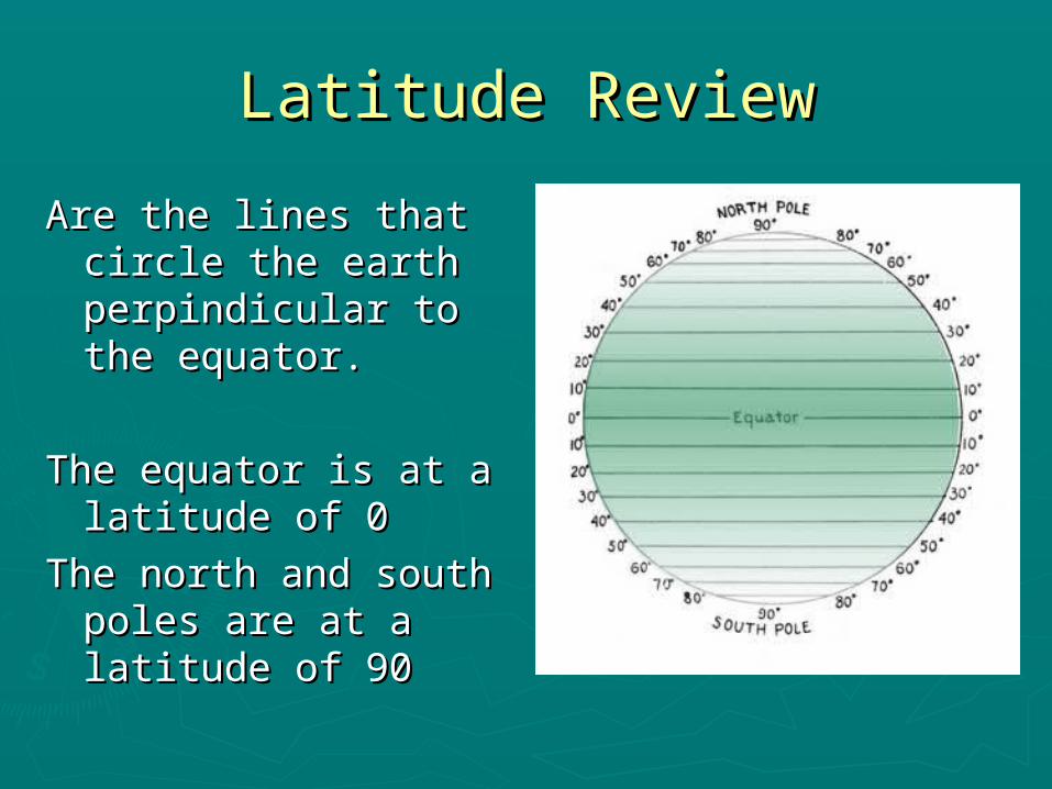
Quest for Longitude Celestial Navigation Week 2. Latitude Review Are the lines that circle the earth...
31
Quest for Longitude Quest for Longitude Celestial Navigation Celestial Navigation Week 2 Week 2
-
Upload
madlyn-gallagher -
Category
Documents
-
view
222 -
download
0
Transcript of Quest for Longitude Celestial Navigation Week 2. Latitude Review Are the lines that circle the earth...

Quest for LongitudeQuest for LongitudeCelestial Navigation Celestial Navigation
Week 2Week 2
Latitude ReviewLatitude Review
Are the lines that Are the lines that circle the earth circle the earth perpindicular to the perpindicular to the equator.equator.
The equator is at a The equator is at a latitude of 0latitude of 0
The north and south The north and south poles are at a poles are at a latitude of 90latitude of 90

Review of Calculating Review of Calculating LatitudeLatitude
► Various methodsVarious methods Rule of thumbRule of thumb KamalKamal BackstaffBackstaff Cross staffCross staff QuadrantQuadrant
► Latitude only told you how far North or Latitude only told you how far North or South you wereSouth you were
►What about east or west?What about east or west?

What is LongitudeWhat is Longitude
► Prime MeridianPrime Meridian► Royal Observatory in Royal Observatory in
Greenwich, England Greenwich, England ► Sphere is 360˚Sphere is 360˚► Longitude ranges 0-Longitude ranges 0-
180˚ East or West of 180˚ East or West of the Prime Meridianthe Prime Meridian
► Positive longitude Positive longitude values are east of the values are east of the Prime MeridianPrime Meridian
► Negative longitude Negative longitude values are west of the values are west of the Prime Meridian Prime Meridian
http://en.wikipedia.org/wiki/Longitude

Longitude As the World TurnsLongitude As the World Turns
►The earth rotates every 24 hours.►The earth rotates at complete 360˚►360/24= The amount of degrees the
earth rotates in 1 hour.►How many degrees does the earth
rotate in one hour? ►We will revisit this concept in a little
bit.

Note on the SideNote on the Side
► International Date line is completely International Date line is completely opposite of the Prime Meridian and is opposite of the Prime Meridian and is at 180˚at 180˚
►When it is noon along the prime When it is noon along the prime meridian, it is midnight along the meridian, it is midnight along the International Date Line. International Date Line. http://www.mrdowling.com/601-http://www.mrdowling.com/601-
grid.htmlgrid.html

Triangulation as a ToolTriangulation as a Tool
► On land, triangulation On land, triangulation is fairly simple.is fairly simple.
► Locate two points for Locate two points for intersection, three for intersection, three for triangulation.triangulation.
► Apply basic principles.Apply basic principles.► Locate three pointsLocate three points► Find bearings of all Find bearings of all
three pointsthree points

Chip LogChip Log
► Check out this linkCheck out this link► http://www.youtube.com/watch?v=Zhkr3lbcul0 at http://www.youtube.com/watch?v=Zhkr3lbcul0 at
3:25 minutes into the program3:25 minutes into the program► Worth WatchingWorth Watching
► Wooden block with a first 50’ not counted.Wooden block with a first 50’ not counted.► When the line hits the marker the counter yells When the line hits the marker the counter yells
“CLEAR”“CLEAR”► The time 28 second sand glass is flipped.The time 28 second sand glass is flipped.► The counter counts the knots tied in the rope 48.3 The counter counts the knots tied in the rope 48.3
inches apart in the 28 seconds. inches apart in the 28 seconds. ► This is the speed of the craft.This is the speed of the craft.► What would be possible problems with this methodWhat would be possible problems with this method

Fathom ThatFathom That•Fathom is a measure of depth somewhere around 6’.
•Now our nautical charts measure in feet not fathoms.
•Those are all those tiny numbers written on the nautical charts.
•How would these indicators help navigators?

Deduced ReckoningDeduced Reckoning
You Must Know these things to navigate.►Starting Point – where you were. ►Course – what direction you are
traveling.►Speed – how fast you are traveling.►Time – how long you have been
traveling. ►Speed x Time = Distance

Vector VoyageVector Voyage
►Part 1Part 1 Let’s work through our Vector Voyage Let’s work through our Vector Voyage
Worksheet Part 1Worksheet Part 1

Not Enough!Not Enough!► October 22, 1707October 22, 1707► Isles of ScillyIsles of Scilly► Board of LongitudeBoard of Longitude► Prizes were to be awarded Prizes were to be awarded
to the first person to to the first person to demonstrate a practical demonstrate a practical method for determining the method for determining the longitude of a ship at sea. longitude of a ship at sea.
► These prizes motivated These prizes motivated many to search for a many to search for a solution. solution. ££20,000 (millions)20,000 (millions)
► The Lunar Method was The Lunar Method was being considered as were being considered as were the moons of Jupiter and the the moons of Jupiter and the pattern of Venus.pattern of Venus.

Set and Drift and LeewaySet and Drift and Leeway
►Set is the bearing in which the current is Set is the bearing in which the current is flowingflowing
►Drift is the speed the current is flowingDrift is the speed the current is flowing
►Speed, time, and angle make up leeway.Speed, time, and angle make up leeway.
►http://www.youtube.com/watch?http://www.youtube.com/watch?v=AyqGBa9fexAv=AyqGBa9fexA

Vector VoyageVector Voyage
►Part 2Part 2 Let’s look at the actual voyage.Let’s look at the actual voyage.

Enter John HarrisonEnter John Harrison
► Clock makerClock maker► Took up the Took up the
challenge to find an challenge to find an accurate measure accurate measure of time on the seas.of time on the seas.
► Spent 31 years Spent 31 years working on this working on this problem.problem.
►Humidity, rough Humidity, rough voyage, heat etcvoyage, heat etc

H5 The Sea Clock or H5 The Sea Clock or ChronometerChronometer

The Simplicity of TimeThe Simplicity of Time
► John Harrison made it possible to John Harrison made it possible to calculate longitude by creating an calculate longitude by creating an accurate time keeper. accurate time keeper.
►You could compare the time difference You could compare the time difference to establish your longitude if your clock to establish your longitude if your clock was set off Greenwich Mean Time.was set off Greenwich Mean Time.
►Example!Example!

Longitude As the World TurnsLongitude As the World Turns
►Quick review!►The earth rotates every 24 hours.►The earth rotates at complete 360˚►360/24= 15►The earth rotates at 15˚ each hour

Earth’s Magnetic PoleEarth’s Magnetic Pole
► The Geographic North The Geographic North Pole is different from the Pole is different from the Axis of rotationAxis of rotation
► It is different from the It is different from the Geomagnetic North PoleGeomagnetic North Pole
► This means that This means that following magnetic north following magnetic north will not take you to the will not take you to the North Pole.North Pole.
► This difference has a This difference has a special name called special name called Declination.Declination.

Working DeclinationWorking Declination
►Each map will show a declination value.Each map will show a declination value.►This way you can calibrate your
compass, which is pointing to geomagnetic north.
►You can make it point to the geographic north or True North.
►The geomagnetic pole is located 11 degrees of latitude from the geographic pole

Nautical ChartsNautical Charts
► Nautical charts Nautical charts show the show the declination declination right on the right on the map. map.
► Declination will Declination will alter slightly alter slightly based on your based on your location.location.
► We will cover We will cover more on this in more on this in next week’s next week’s lesson.lesson.

What is a Sextant?What is a Sextant?
► Simple tool that Simple tool that measures the angle measures the angle between the horizon between the horizon and one heavenly and one heavenly body.body.
► This information is This information is then used with the then used with the Nautical Almanac to Nautical Almanac to pinpoint your pinpoint your location.location.

How a Sextant WorksHow a Sextant Works► If your sextant reading is taken at noon (the sun’s If your sextant reading is taken at noon (the sun’s
zenith) that will give you your latitude.zenith) that will give you your latitude.► If it is not noon, when your sextant reading is taken, you If it is not noon, when your sextant reading is taken, you
must note the exact time using a marine chronometer must note the exact time using a marine chronometer (really good watch set to Greenwich Mean Time). (really good watch set to Greenwich Mean Time).
► You will look up the time and sextant reading in the You will look up the time and sextant reading in the nautical almanac for the heavenly body you are using.nautical almanac for the heavenly body you are using.
► Noon our time compared with noon Greenwich Mean Noon our time compared with noon Greenwich Mean Time, will give us 15 degrees of longitude for each hour. Time, will give us 15 degrees of longitude for each hour.
► This will let you know where you are.This will let you know where you are.
► We will explore nautical almanacs and charts a bit more We will explore nautical almanacs and charts a bit more in depth next week.in depth next week.

Nautical AlmanacNautical Almanac
►The Almanac specifies for each whole The Almanac specifies for each whole hour of the year the position on the hour of the year the position on the Earth's surface in Greenwich Mean time Earth's surface in Greenwich Mean time and declination of the sun, moon, and and declination of the sun, moon, and stars.stars.
►Remember that there are 57 selected Remember that there are 57 selected stars for navigation.stars for navigation.
►Using a nautical Almanac is in the next Using a nautical Almanac is in the next lesson as we find our location.lesson as we find our location.

Final NotesFinal Notes
► Next week we will use the Nautical Almanac and Next week we will use the Nautical Almanac and Nautical Charts.Nautical Charts.
► Adjust our bearing for Declination based of the Adjust our bearing for Declination based of the Chart.Chart.
► Use an orienteering compass to find and pin point Use an orienteering compass to find and pin point our location in a coastal setting.our location in a coastal setting.
► We will use the sextant for a few examples, so We will use the sextant for a few examples, so please bring it with you next week.please bring it with you next week.
► Do not use the sextant to look at the direct Do not use the sextant to look at the direct sunlight. I will try to get black and white silvered sunlight. I will try to get black and white silvered film for vision protection for next week. UV rays will film for vision protection for next week. UV rays will cause damage to your eyes.cause damage to your eyes.

Making a CD SextantMaking a CD SextantSlide 1Slide 1
►This great activity is from the website This great activity is from the website linked below. Thank you!linked below. Thank you!
►The website has a file for printing to scale The website has a file for printing to scale the sextant markings on sticker paper.the sextant markings on sticker paper.
► http://www.tecepe.com.br/nav/CDSextantProject.htmhttp://www.tecepe.com.br/nav/CDSextantProject.htm

Making a CD SextantMaking a CD SextantSlide 2Slide 2
►Gather up SuppliesGather up Supplies► Print the scale on Print the scale on
sticker papersticker paper► Cut out the sextant Cut out the sextant
scale.scale.► Be sure to set aside Be sure to set aside
the vernier scale.the vernier scale.► Center extremely Center extremely
carefully over the carefully over the center hole of the center hole of the CD.CD.

Making a CD SextantMaking a CD SextantSlide 3Slide 3
► Trim the center holeTrim the center hole► Place in Case, Place in Case,
removing lidremoving lid► Remove the silver Remove the silver
backing to one half backing to one half (lengthwise of the (lengthwise of the mirror) of one of the mirror) of one of the mirrorsmirrors

Making a CD SextantMaking a CD SextantSlide 4Slide 4
►Glue your legos to Glue your legos to the mirrorsthe mirrors
►Assemble your Assemble your SextantSextant

Making a CD SextantMaking a CD SextantSlide 5Slide 5
►Calibrate with a distant focal pointCalibrate with a distant focal point►Dots on the wall.Dots on the wall.►Then at zero add your Vernier scaleThen at zero add your Vernier scale

Using Your Sextant!Using Your Sextant!
► http://http://www.tecepe.com.br/www.tecepe.com.br/nav/nav/CDSextantProject.htmCDSextantProject.htm
► We will use and We will use and demonstrate our sextants demonstrate our sextants using the full moon using the full moon tonight.tonight.
► Place the view finder on Place the view finder on the horizonthe horizon
► Bring down the moon Bring down the moon until it sits on the horizon.until it sits on the horizon.