Quaternary glaciation in the Nubra and Shyok valley confluence ...
13
Quaternary glaciation in the Nubra and Shyok valley confluence, northernmost Ladakh, India Jason M. Dortch a, ⁎, Lewis A. Owen a , Marc W. Caffee b a Department of Geology, University of Cincinnati, Cincinnati, OH45221, USA b Dept of Physics/PRIME Laboratory, Purdue University, West Lafayette, IN 47906, USA abstract article info Article history: Received 13 November 2009 Keywords: Himalaya Karakoram Ladakh Range Mountain glaciation Geochronology Moraines Cosmogenics ELA Three glacial stages (Deshkit 1, Deshkit 2 and Dishkit 3 glacial stages) are identified in the Nubra and Shyok valleys in northernmost Ladakh, northwest India, on the basis of geomorphic field mapping, remote sensing, and 10 Be terrestrial cosmogenic nuclide surface exposure dating. The glacial stages date to ∼ 45 ka (Deshkit 1 glacial stage), ∼ 81 ka (Deshkit 2 glacial stage) and ∼ 144 ka (Deshkit 3 glacial stage). A mean equilibrium line altitude depression of ∼ 290 m for the Deshkit 1 glacial stage was calculated using the area accumulation ratio, toe-to-headwall ratio, area–altitude, and area–altitude balance ratio methods. Comparison of glaciation in the Nubra and Shyok valleys with glaciations in the adjacent Central Karakoram of northern Pakistan and northern side of the Ladakh Range of northern India indicates that glaciation was synchronous on Milankovitch timescales across the region during MIS-6, but differed greatly in extent, with more extensive glaciation in the Karakoram than the morphostratigraphically equivalent glaciation on the northern slopes of the Ladakh Range. This highlights the strong contrast in the extent of glaciation across ranges in the Himalaya–Tibetan orogen, necessitating caution when correlating glacial successions within and between mountain ranges. © 2010 Univesity of Washington. Published by Elsevier Inc. All rights reserved. Introduction During the last decade, numerical dating methods utilizing terrestrial cosmogenic nuclide surface exposure and luminescence dating have illustrated the complexity of glacial successions and glaciation in the Himalayan–Tibetan orogen (e.g. Owen et al., 2001, 2003, 2008, 2009; Phillips et al., 2000; Richards et al., 2000a, b; Seong et al., 2007, 2009; Zech et al., 2000, 2003, 2005). These studies indicate that contrasting patterns of glaciation exist across adjacent regions of the Himalaya, which are likely due to a combination of orographic and climatic influences (Owen et al., 2008). Accordingly, the investigation of these variations in the patterns of glaciation requires the development of regional-scale glacial chronologies. As part of this endeavor, we examine glacial geologic records in the Nubra and Shyok valleys in northernmost Ladakh of northwest India using geomorphic mapping, aided by remote sensing, and 10 Be terrestrial cosmogenic nuclide surface exposure dating of glacial landforms (Fig. 1). North- ernmost Ladakh is an ideal study area because: 1) the adjacent regions have been the focus of prior glacial geologic studies that can be used to examine regional differences in glaciation; 2) the semi-arid climate of the region preserves a long and detailed glacial record; and 3) the region is relatively accessible. Regional setting The Nubra and Shyok valleys are situated in the Transhimalaya and span the Central Karakoram and Ladakh Range of northwest India and northern Pakistan (Fig. 1). The region is bisected by the Karakoram Fault, a NW trending, continental scale, right-lateral strike-slip fault separating the Central Karakoram and Ladakh Range (Dunlap et al., 1998; Searle et al. 1998, Searle and Richard, 2007; Chevalier et al., 2005). The Central Karakoram contains four N 8000 m peaks (K2 at 8611 m above sea level [a.s.l.], Gasherbrum 1 at 8068 m a.s.l., Gasherbrum 2 at 8034 m a.s.l., and Broad Peak at 8047 m a.s.l.) and is heavily glaciated. Two major glacial systems, the Baltoro and Siachen, extend for ∼ 55 km and ∼ 70 km throughout the Central Karakoram, respectively, and N 30 glaciers longer than 20 km are found within the range. The valleys of the Central Karakoram are deeply incised, with a relative relief of ≥5000 m. In contrast, the Ladakh Range has a relative relief of 1000 m to 2000 m, with few peaks higher than 7000 m a.s.l. Glaciers in the Ladakh Range are generally restricted to cirques and are typically b 4.5 km long. Precipitation in the Central Karakoram is dominated by the mid- latitude westerlies, with 2/3 of the precipitation occurring during winter (Hewitt, 1989). The peaks of the NW Lesser Himalaya, with a Quaternary Research 74 (2010) 132–144 ⁎ Corresponding author. E-mail address: [email protected] (J.M. Dortch). 0033-5894/$ – see front matter © 2010 Univesity of Washington. Published by Elsevier Inc. All rights reserved. doi:10.1016/j.yqres.2010.04.013 Contents lists available at ScienceDirect Quaternary Research journal homepage: www.elsevier.com/locate/yqres
Transcript of Quaternary glaciation in the Nubra and Shyok valley confluence ...
Quaternary Research 74 (2010) 132–144
Contents lists available at ScienceDirect
Quaternary Research
j ourna l homepage: www.e lsev ie r.com/ locate /yqres
Quaternary glaciation in the Nubra and Shyok valley confluence, northernmostLadakh, India
Jason M. Dortch a,⁎, Lewis A. Owen a, Marc W. Caffee b
a Department of Geology, University of Cincinnati, Cincinnati, OH45221, USAb Dept of Physics/PRIME Laboratory, Purdue University, West Lafayette, IN 47906, USA
⁎ Corresponding author.E-mail address: [email protected] (J.M. Dortch)
0033-5894/$ – see front matter © 2010 Univesity of Wdoi:10.1016/j.yqres.2010.04.013
a b s t r a c t
a r t i c l e i n f oArticle history:Received 13 November 2009
Keywords:HimalayaKarakoramLadakh RangeMountain glaciationGeochronologyMorainesCosmogenicsELA
Three glacial stages (Deshkit 1, Deshkit 2 and Dishkit 3 glacial stages) are identified in the Nubra and Shyokvalleys in northernmost Ladakh, northwest India, on the basis of geomorphic field mapping, remote sensing,and
10Be terrestrial cosmogenic nuclide surface exposure dating. The glacial stages date to ∼45 ka (Deshkit 1
glacial stage), ∼81 ka (Deshkit 2 glacial stage) and ∼144 ka (Deshkit 3 glacial stage). A mean equilibrium linealtitude depression of ∼290 m for the Deshkit 1 glacial stage was calculated using the area accumulationratio, toe-to-headwall ratio, area–altitude, and area–altitude balance ratio methods. Comparison of glaciationin the Nubra and Shyok valleys with glaciations in the adjacent Central Karakoram of northern Pakistan andnorthern side of the Ladakh Range of northern India indicates that glaciation was synchronous onMilankovitch timescales across the region during MIS-6, but differed greatly in extent, with more extensiveglaciation in the Karakoram than the morphostratigraphically equivalent glaciation on the northern slopes ofthe Ladakh Range. This highlights the strong contrast in the extent of glaciation across ranges in theHimalaya–Tibetan orogen, necessitating caution when correlating glacial successions within and betweenmountain ranges.
© 2010 Univesity of Washington. Published by Elsevier Inc. All rights reserved.
Introduction
During the last decade, numerical dating methods utilizingterrestrial cosmogenic nuclide surface exposure and luminescencedating have illustrated the complexity of glacial successions andglaciation in the Himalayan–Tibetan orogen (e.g. Owen et al., 2001,2003, 2008, 2009; Phillips et al., 2000; Richards et al., 2000a, b; Seonget al., 2007, 2009; Zech et al., 2000, 2003, 2005). These studies indicatethat contrasting patterns of glaciation exist across adjacent regions ofthe Himalaya, which are likely due to a combination of orographic andclimatic influences (Owen et al., 2008). Accordingly, the investigationof these variations in the patterns of glaciation requires thedevelopment of regional-scale glacial chronologies. As part of thisendeavor, we examine glacial geologic records in the Nubra and Shyokvalleys in northernmost Ladakh of northwest India using geomorphicmapping, aided by remote sensing, and 10Be terrestrial cosmogenicnuclide surface exposure dating of glacial landforms (Fig. 1). North-ernmost Ladakh is an ideal study area because: 1) the adjacent regionshave been the focus of prior glacial geologic studies that can be used toexamine regional differences in glaciation; 2) the semi-arid climate of
.
ashington. Published by Elsevier In
the region preserves a long and detailed glacial record; and 3) theregion is relatively accessible.
Regional setting
The Nubra and Shyok valleys are situated in the Transhimalaya andspan the Central Karakoram and Ladakh Range of northwest India andnorthern Pakistan (Fig. 1). The region is bisected by the KarakoramFault, a NW trending, continental scale, right-lateral strike-slip faultseparating the Central Karakoram and Ladakh Range (Dunlap et al.,1998; Searle et al. 1998, Searle and Richard, 2007; Chevalier et al.,2005). The Central Karakoram contains four N8000 m peaks (K2 at8611 m above sea level [a.s.l.], Gasherbrum 1 at 8068 m a.s.l.,Gasherbrum 2 at 8034 m a.s.l., and Broad Peak at 8047 m a.s.l.) andis heavily glaciated. Two major glacial systems, the Baltoro andSiachen, extend for ∼55 km and ∼70 km throughout the CentralKarakoram, respectively, and N30 glaciers longer than 20 km arefound within the range. The valleys of the Central Karakoram aredeeply incised, with a relative relief of ≥5000 m. In contrast, theLadakh Range has a relative relief of 1000 m to 2000 m, with fewpeaks higher than 7000 m a.s.l. Glaciers in the Ladakh Range aregenerally restricted to cirques and are typically b4.5 km long.
Precipitation in the Central Karakoram is dominated by the mid-latitude westerlies, with 2/3 of the precipitation occurring duringwinter (Hewitt, 1989). The peaks of the NW Lesser Himalaya, with a
c. All rights reserved.
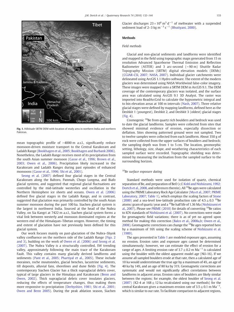
Fig. 1. Hillshade SRTM DEM with location of study area in northern India and northernPakistan.
133J.M. Dortch et al. / Quaternary Research 74 (2010) 132–144
mean topographic profile of N4000 m a.s.l., significantly reducemonsoon-driven moisture transport to the Central Karakoram andLadakh Range (Bookhagen et al., 2005; Bookhagen and Burbank 2006).Nonetheless, the Ladakh Range receives most of its precipitation fromthe south Asian summer monsoon (Gasse et al., 1996; Brown et al.,2003; Owen et al., 2006). Precipitation likely increased in theKarakoram and Ladakh Ranges during past episodes of enhancedmonsoons (Gasse et al., 1996; Shi et al., 2001).
Seong et al. (2007) defined four glacial stages in the CentralKarakoram along the Baltoro, Panmah, Chogo Lungma, and Biafoglacial systems, and suggested that regional glacial fluctuations arecontrolled by the mid-latitude westerlies and oscillation in theNorthern Hemisphere ice sheets and oceans. Owen et al. (2006)defined five glacial stages in the Ladakh Range, and in contrast,suggested that glaciation was primarily controlled by the south Asiansummer monsoon during the past 100 ka. Siachen glacial system isthe largest in northwest India. Sourced at the head of the NubraValley, on Sia Kangri at 7422 m a.s.l., Siachen glacial system forms avital link between westerly and monsoon dominated regions at thewestern end of the Himalayan–Tibetan orogen. However, the timingand extent of glaciation have not previously been defined for thisglacial system.
Our work focuses mainly on past-glaciation of the Nubra–Shyokvalley confluence on the northern side of the Ladakh Range (Figs. 2and 3), building on the work of Owen et al. (2006) and Seong et al.(2007). The Nubra Valley is a structurally controlled, SW trendingvalley, approximately following the main trace of the KarakoramFault. This valley contains many glacially derived landforms andsediments (Pant et al., 2005; Phartiyal et al., 2005). These includemoraines, roche moutonnées, glacial benches, lacustrine sediments,till deposits, alluvial fans, shorelines and dune fields (Fig. 4). Thecontemporary Siachen Glacier has a thick supraglacial debris cover,typical of large glaciers in the Himalaya and Karakoram (Benn andOwen, 2002). Thick supraglacial debris cover insulates glaciers,reducing the effects of temperature changes, thus making themmore responsive to precipitation (Derbyshire, 1981; Shi et al., 2001;Owen and Benn 2005). During the peak ablation season, Siachen
Glacier discharges 23×106 m3 d−1 of meltwater with a suspendedsediment load of 2–3 kg m−3 s−1 (Bhutiyani, 2000).
Methods
Field methods
Glacial and non-glacial sediments and landforms were identifiedandmapped in the field using topographic maps generated from 15 mresolution Advanced Spaceborne Thermal Emission and ReflectionRadiometer (ASTER) and 3 arc-second (∼90 m) Shuttle RadarTopography Mission (SRTM) digital elevation models (DEMs)(CGIAR-CSI, 2007; NASA, 2007). Individual glacier catchments weredelineated using ArcGIS 1.1 Hydro software. The extent of the modernglaciers was determined using NASA Worldwind false-color imagery.These images were mapped onto a SRTM DEM in ArcGIS 9.1. The DEMcoverage of the contemporary glaciers was isolated, and the surfacearea was calculated using ArcGIS 9.1 3D Analyst. The raster wasimported into ReadArcGrid to calculate the hypsometric integral andto bin elevation areas at 100 m intervals (Nash, 2007). Three relativeglacial stages were defined bymapping landforms, defined here as theDeshkit 1 (youngest), Deshkit 2, and Deshkit 3 (oldest) glacial stages(Fig. 4).
Cosmogenic 10Be from quartz rich boulders and bedrock was usedto date the glacial landforms. Samples were collected from sites thatshowed minimal evidence of erosion, especially dissection ordeflation. Sites showing patterned ground were not sampled. Twoto twelve samples were collected from each landform. About 350 g ofrock were collected from the upper surfaces of boulders and bedrock;the sampling depth was from 1 to 5 cm. The location, geomorphicsetting, lithology, size, shape, and weathering characteristics of eachsampled surface were recorded. Topographic shielding was deter-mined by measuring the inclination from the sampled surface to thesurrounding horizon.
10Be surface exposure dating
Standard methods were used for isolation of quartz, chemicalseparation of Be, and preparation of BeO (c.f. Kohl andNishiizumi, 1992;Dortch et al., 2008, and references therein). All 10Be ageswere calculatedusing the PRIME Laboratory Rock Age Calculator (Ma et al., 2007; PRIMELaboratory, 2007; Table 1), which employs the scaling factors of Stone(2000) and a sea-level low-latitude production rate of 4.5±0.3 10Beatoms/gramof quartz/year and a 10Behalf life of 1.36 Ma (Nishiizumi etal., 2007). Please see PRIME (2010) for details of converting 10Be ratiosto ICN standards of Nishiizumi et al. (2007). No corrections were madefor geomagnetic field variations; there is as of yet no agreed uponmethod for making this correction (Balco et al., 2008a,b; Owen et al.,2008). Geomagnetic corrections can change the 10Be ages reported hereby a maximum of 16% using the scaling scheme of Nishiizumi et al.(1989).
The ages presented in Table 1 are modeled exposure ages, assumingno erosion. Erosion rates and exposure ages cannot be determinedsimultaneously; however, we can estimate the effect of erosion for arange of ages. A limiting erosion rate of 3.7±0.2 m Ma−1 is calculatedusing the boulder with the oldest apparent model age (NU-16). If weassume all sampled boulders erode at that rate, then a calculated age of10 ka would underestimate the true age by amaximum of 4%, an age of40 ka by 14%, and an age of 80 ka by 31%. Geomagnetic corrections aresystematic and would not significantly affect correlations betweenlandforms in adjacent areas. Erosion rates of boulders are likely similarbetween the regions; for example, the oldest boulder of Seong et al.(2007) (K2-4 at 168±12 ka recalculated using our methods) for thecentral Karakoram gives a maximum erosion rate of 3.5±0.1 m Ma−1,which is similar to our rate. To facilitate comparison to adjacent regions,
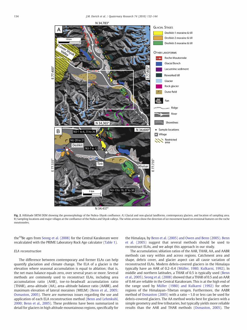
Fig. 2. Hillshade SRTM DEM showing the geomorphology of the Nubra–Shyok confluence. A) Glacial and non-glacial landforms, contemporary glaciers, and location of sampling area.B) Sampling locations andmajor villages at the confluence of the Nubra and Shyok valleys. Thewhite arrows show the direction of icemovement based on erosional features on the rochemoutonnées.
134 J.M. Dortch et al. / Quaternary Research 74 (2010) 132–144
the10Be ages from Seong et al. (2008) for the Central Karakoram wererecalculated with the PRIME Laboratory Rock Age calculator (Table 1).
ELA reconstruction
The difference between contemporary and former ELAs can helpquantify glaciation and climate change. The ELA of a glacier is theelevation where seasonal accumulation is equal to ablation; that is,the net mass balance equals zero, over several years or more. Severalmethods are commonly used to reconstruct ELAs, including areaaccumulation ratio (AAR), toe-to-headwall accumulation ratio(THAR), area–altitude (AA), area–altitude balance ratio (AABR), andmaximum elevation of lateral moraines (MELM) (Benn et al., 2005;Osmaston, 2005). There are numerous issues regarding the use andapplication of each ELA reconstruction method (Benn and Lehmkuhl,2000; Benn et al., 2005). These problems have been summarized indetail for glaciers in high altitudemountainous regions, specifically for
the Himalaya, by Benn et al. (2005) and Owen and Benn (2005). Bennet al. (2005) suggest that several methods should be used toreconstruct ELAs, and we adopt this approach in our study.
The accumulation/ablation ratios of the AAR, THAR, AA, and AABRmethods can vary within and across regions. Catchment area andshape, debris cover, and glacier aspect can all cause variation ofreconstructed ELAs. Modern debris-covered glaciers in the Himalayatypically have an AAR of 0.2–0.4 (Müller, 1980; Kulkarni, 1992). Inmiddle and northern latitudes, a THAR of 0.5 is typically used (Bennet al., 2005). Seong et al. (2008) showed that a THAR of 0.5 and an AARof 0.44 are reliable in the Central Karakoram. This is at the high end ofthe range used by Müller (1980) and Kulkarni (1992) for otherregions of the Himalayan–Tibetan orogen. Furthermore, the AABRmethod of Osmaston (2005) with a ratio ∼1.0 or less can be used fordebris-covered glaciers. The AA method works best for glaciers with asimple geometry and few tributaries, but typically yieldsmore reliableresults than the AAR and THAR methods (Osmaston, 2005). The
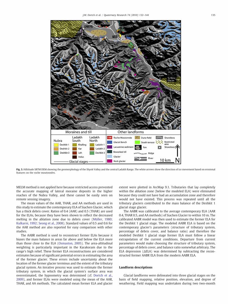
Fig. 3.Hillshade SRTMDEM showing the geomorphology of the Shyok Valley and the central Ladakh Range. The white arrows show the direction of ice movement based on erosionalfeatures on the roche moutonnées.
135J.M. Dortch et al. / Quaternary Research 74 (2010) 132–144
MELMmethod is not applied here because restricted access preventedthe accurate mapping of lateral moraine deposits in the higherreaches of the Nubra Valley, and these cannot be easily seen onremote sensing imagery.
The mean values of the AAR, THAR, and AA methods are used inthis study to estimate the contemporary ELA of Siachen Glacier, whichhas a thick debris cover. Ratios of 0.4 (AAR) and 0.5 (THAR) are usedfor the ELAs, because they have been shown to reflect the decreasedmelting in the ablation zone due to debris cover (Müller, 1980;Kulkarni, 1992; Seong et al., 2008). Standard values of 0.5 and 0.6 forthe AAR method are also reported for easy comparison with otherstudies.
The AABR method is used to reconstruct former ELAs because itbiases the mass balance in areas far above and below the ELA morethan those close to the ELA (Osmaston, 2005). The area-altitudinalweighting is particularly important in the Karakoram due to therange's high relief. These former ELA reconstructions are consideredestimates because of significant potential errors in estimating the areaof the former glacier. These errors include uncertainty about thelocation of the former glacier terminus and the extent of the tributaryglacial system. An iterative process was used to estimate the formertributary system, in which the glacial system's surface area wasoverestimated, the hypsometry was determined (cf. Dortch et al.,2009), and former ELAs were modeled using the mean of the AAR,THAR, and AA methods. The calculated mean former ELA and glacier
extent were plotted in ArcMap 9.1. Tributaries that lay completelywithin the ablation zone (below the modeled ELA) were eliminatedbecause they could not have had an accumulation zone and thereforewould not have existed. This process was repeated until all thetributary glaciers contributed to the mass balance of the Deshkit 1glacial stage glacier.
The AABR was calibrated to the average contemporary ELA (AAR0.4, THAR 0.5, and AAmethods) of Siachen Glacier to within 10 m. Thecalibrated AABR model was then used to estimate the former ELA forthe Deshkit 1 glacial stage. The modeled AABR ELA is based on thecontemporary glacier's parameters (structure of tributary system,percentage of debris cover, and balance ratio) and therefore themodeled Deshkit 1 glacial stage former ELA must follow a linearextrapolation of the current conditions. Departure from currentparameters would make choosing the structure of tributary system,percentage of debris cover, and balance ratio somewhat arbitrary. TheELA depression (ΔELA) was determined by subtracting the recon-structed former AABR ELA from the modern AABR ELA.
Landform descriptions
Glacial landforms were delineated into three glacial stages on thebasis of field mapping, relative position, elevation, and degree ofweathering. Field mapping was undertaken during two two-month
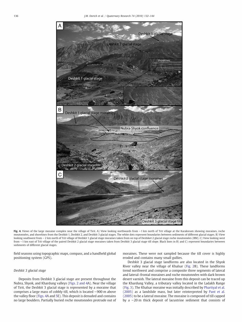
Fig. 4. Views of the large moraine complex near the village of Tirit. A) View looking northwards from ∼1 km north of Trit village at the Karakoram showing moraines, rochemoutonnées, and shorelines from the Deshkit 1, Deshkit 2, and Deshkit 3 glacial stages. The white dots represent boundaries between sediments of different glacial stages. B) Viewlooking southwest from ∼ 2 km north of Trit village of Deshkit 1 glacial stage moraines taken from on top of Deshiket 2 glacial stage roche moutonnées (RM). C) View looking westfrom ∼1 km east of Trit village of the paired Deshkit 2 glacial stage moraines taken from Deshkit 3 glacial stage till slope. Black lines in B) and C) represent boundaries betweensediments of different glacial stages.
136 J.M. Dortch et al. / Quaternary Research 74 (2010) 132–144
field seasons using topographic maps, compass, and a handheld globalpositioning system (GPS).
Deshkit 3 glacial stage
Deposits from Deshkit 3 glacial stage are present throughout theNubra, Shyok, and Khardung valleys (Figs. 2 and 4A). Near the villageof Tirit, the Deshkit 3 glacial stage is represented by a moraine thatcomprises a large mass of cobbly till, which is located ∼900 m abovethe valley floor (Figs. 4A and 5E). This deposit is denuded and containsno large boulders. Partially buried roche moutonnées protrude out of
moraines. These were not sampled because the till cover is highlyeroded and contains many small gullies.
Deshkit 3 glacial stage landforms are also located in the ShyokRiver valley near the village of Khalsar (Fig. 2B). These landformstrend northwest and comprise a composite three segments of lateraland lateral–frontal moraines and roche moutonnées with dark browndesert varnish. The lateral moraine from this deposit can be traced upthe Khardung Valley, a tributary valley located in the Ladakh Range(Fig. 3). The Khalsar moraine was initially described by Phartiyal et al.(2005) as a landslide mass, but later reinterpreted by Pant et al.(2005) to be a lateral moraine. Themoraine is composed of till cappedby a ∼20 m thick deposit of lacustrine sediment that consists of
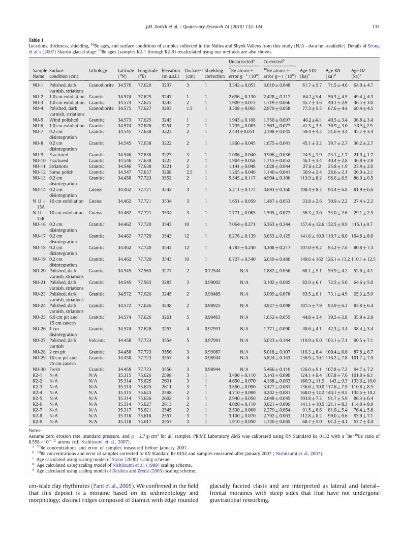
Table 1Locations, thickness, shielding, 10Be ages, and surface conditions of samples collected in the Nubra and Shyok Valleys from this study (N/A - data not available). Details of Seonget al.'s (2007) Skardu glacial stage 10Be ages (samples K2-1 through K2-9) recalculated using our methods are also shown.
Uncorrecteda Correctedb
SampleName
Surfacecondition (cm)
Lithology Latitude(oN)
Longitude(oE)
Elevation(m a.s.l.)
Thickness(cm)
Shieldingcorrection
10Be atoms±
error g−1 (106)
10Be atoms±error g−1 (106)
Age STD(ka)c
Age KN(ka)d
Age DZ(ka)e
NU-1 Polished, darkvarnish, striations
Granodiorite 34.570 77.620 3237 3 1 3.342±0.053 3.010±0.048 81.7±5.7 71.5±4.6 64.0±4.7
NU-2 1.0 cm exfoliation Granitic 34.574 77.625 3247 1 1 2.696±0.130 2.428±0.117 64.2±5.4 56.3±4.5 49.4±4.3NU-3 1.0 cm exfoliation Granitic 34.574 77.625 3243 2 1 1.909±0.073 1.719±0.066 45.7±3.6 40.1±2.9 36.5±3.0NU-4 Polished, dark
varnish, striationsGranodiorite 34.575 77.627 3293 1.5 1 3.308±0.065 2.979±0.058 77.3±5.5 67.6±4.4 60.4±4.5
NU-5 Wind polished Granitic 34.573 77.625 3243 1 1 1.943±0.108 1.750±0.097 46.2±4.1 40.5±3.4 36.8±3.4NU-6 1.0 cm exfoliation Granitic 34.574 77.626 3251 2 1 1.735±0.085 1.563±0.077 41.3±3.5 36.9±3.0 33.5±2.9NU-7 0.2 cm
disintegrationGranitic 34.545 77.638 3223 2 1 2.441±0.051 2.198±0.045 59.4±4.2 51.6±3.4 45.7±3.4
NU-8 0.2 cmdisintegration
Granitic 34.545 77.638 3222 2 1 1.860±0.045 1.675±0.041 45.1±3.2 39.7±2.7 36.2±2.7
NU-9 Fractured Granitic 34.546 77.638 3223 3 1 1.006±0.040 0.906±0.036 24.5±1.9 23.1±1.7 21.0±1.7NU-10 Fractured Granitic 34.546 77.638 3225 2 1 1.904±0.058 1.715±0.052 46.1±3.4 40.4±2.8 36.8±2.9NU-11 Striations Granitic 34.546 77.638 3221 2 1 1.141±0.048 1.028±0.044 27.6±2.2 25.8±1.9 23.4±2.0NU-12 Some polish Granitic 34.547 77.637 3208 2.5 1 1.265±0.046 1.140±0.041 30.9±2.4 28.6±2.1 26.0±2.1NU-13 0.2 cm
disintegrationGranitic 34.458 77.723 3552 2 1 5.545±0.117 4.994±0.106 113.9±8.2 98.6±6.5 86.0±6.5
NU-14 0.2 cmdisintegration
Gneiss 34.462 77.721 3542 3 1 5.211±0.177 4.693±0.160 108.4±8.3 94.4±6.8 81.9±6.6
N U -15A
10 cm exfoliation Gneiss 34.462 77.721 3534 3 1 1.651±0.059 1.487±0.053 33.8±2.6 30.9±2.2 27.4±2.2
N U -15B
10 cm exfoliation Gneiss 34.462 77.721 3534 3 1 1.771±0.085 1.595±0.077 36.3±3.0 33.0±2.6 29.1±2.5
NU-16 0.2 cmdisintegration
Granitic 34.462 77.720 3543 10 1 7.064±0.271 6.363±0.244 157.4±12.6 132.5±9.9 115.1±9.7
NU-17 0.2 cmdisintegration
Granitic 34.462 77.720 3543 12 1 6.276±0.139 5.653±0.125 141.6±10.3 119.7±8.0 104.8±8.0
NU-18 0.2 cmdisintegration
Granitic 34.462 77.720 3543 12 1 4.783±0.240 4.308±0.217 107.0±9.2 93.2±7.6 80.8±7.3
NU-19 0.2 cmdisintegration
Granitic 34.462 77.720 3543 10 1 6.727±0.540 6.059±0.486 149.6±162 126.1±13.2 110.1±12.5
NU-20 Polished, darkvarnish, striations
Granitic 34.545 77.563 3277 2 0.72544 N/A 1.882±0.056 68.1±5.1 59.9±4.2 52.6±4.1
NU-21 Polished, darkvarnish, striations
Granitic 34.545 77.563 3283 3 0.99002 N/A 3.102±0.085 82.9±6.1 72.5±5.0 64.6±5.0
NU-23 Polished, darkvarnish, striations
Granitic 34.572 77.626 3245 2 0.99485 N/A 3.099±0.078 83.5±6.1 73.1±4.9 65.3±5.0
NU-24 Polished, darkvarnish, striations
Granitic 34.572 77.626 3238 2 0.98925 N/A 3.927±0.098 107.5±7.9 93.9±6.3 83.8±6.4
NU-25 6.0 cm pit and15 cm cavern
Granitic 34.574 77.626 3261 5 0.99463 N/A 1.652±0.055 44.8±3.4 39.5±2.8 35.9±2.8
NU-26 1 cmdisintegration
Granitic 34.574 77.626 3253 4 0.97991 N/A 1.771±0.090 48.6±4.1 42.3±3.4 38.4±3.4
NU-27 Polished, darkvarnish
Volcanic 34.458 77.723 3554 5 0.97991 N/A 5.023±0.144 119.9±9.0 103.1±7.1 90.5±7.1
NU-28 2 cm pit Granitic 34.458 77.723 3556 3 0.99087 N/A 5.018±0.107 116.3±8.4 100.4±6.6 87.8±6.7NU-29 10 cm pit and
75 cm cavernGranitic 34.458 77.723 3557 4 0.98944 N/A 5.824±0.143 136.9±10.1 116.2±7.8 101.7±7.9
NU-30 Fresh Granitic 34.458 77.723 3556 3 0.98944 N/A 5.466±0.119 126.0±9.1 107.8±7.2 94.7±7.2K2-1 N/A N/A 35.315 75.626 2598 3 1 3.490±0.110 3.143±0.099 124.1±9.4 107.8±7.6 101.8±8.1K2-2 N/A N/A 35.314 75.625 2601 3 1 4.650±0.070 4.188±0.063 166.9±11.9 143±9.3 133.6±10.0K2-3 N/A N/A 35.314 75.625 2611 3 1 3.860±0.090 3.477±0.081 136.6±10.0 117.6±7.9 110.8±8.5K2-4 N/A N/A 35.315 75.623 2598 2 1 4.710±0.090 4.242±0.081 168.0±12.2 144.1±9.5 134.5±10.2K2-5 N/A N/A 35.314 75.626 2602 3 1 2.940±0.050 2.648±0.045 103.8±7.3 91.7±5.9 86.3±6.4K2-6 N/A N/A 35.314 75.627 2613 2 1 4.020±0.110 3.621±0.099 141.1±10.5 121.1±8.3 114.0±8.9K2-7 N/A N/A 35.317 75.621 2545 2 1 2.530±0.060 2.279±0.054 91.5±6.6 81.0±5.4 76.4±5.8K2-8 N/A N/A 35.318 75.618 2557 3 1 3.100±0.070 2.792±0.063 112.8±8.2 99.0±6.6 93.9±7.1K2-9 N/A N/A 35.318 75.617 2557 3 1 1.910±0.050 1.720±0.045 68.7±5.0 61.2±4.1 57.7±4.4
Notes-Assume zero erosion rate, standard pressure, and ρ=2.7 g/cm3 for all samples. PRIME Laboratory AMS was calibrated using KN Standard Be 0152 with a
9Be/10Be ratio of
8.558×10⁻¹² atoms (c.f. Nishiizumi et al., 2007).a 10Be concentrations and error of samples measured before January 2007.b 10Be concentrations and error of samples corrected to KN Standard Be 0152 and samples measured after January 2007 ( Nishiizumi et al., 2007).c Age calculated using scaling model of Stone (2000) scaling scheme.d Age calculated using scaling model of Nishiizumi et al. (1989) scaling scheme.e Age calculated using scaling model of Desilets and Zreda (2003) scaling scheme.
137J.M. Dortch et al. / Quaternary Research 74 (2010) 132–144
cm-scale clay rhythmites (Pant et al., 2005). We confirmed in the fieldthat this deposit is a moraine based on its sedimentology andmorphology; distinct ridges composed of diamict with edge rounded
glacially faceted clasts and are interpreted as lateral and lateral–frontal moraines with steep sides that that have not undergonegravitational reworking.
138 J.M. Dortch et al. / Quaternary Research 74 (2010) 132–144
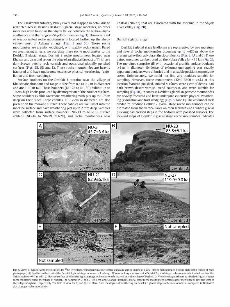
The Karakoram tributary valleys were not mapped in detail due torestricted access. Besides Deshkit 3 glacial stage moraines, no othermoraines were found in the Shyok Valley between the Nubra–Shyokconfluence and the Tangyar–Shyok confluence (Fig. 3). However, a setof west-oriented roche moutonnées is located farther up the Shyokvalley, west of Agham village (Figs. 3 and 5F). These rochemoutonnées are granitic, exfoliated, with patchy rock varnish. Basedon weathering criteria, we correlate these roche moutonnées to theDeshkit 3 glacial stage. Deshkit 3 roche moutonnées located nearKhalsar and a second set on the edge of an alluvial fan east of Tirit havedark brown patchy rock varnish and occasional glacially polishedsurfaces (Figs. 2B, 5D and E). These roche moutonnées are heavilyfractured and have undergone extensive physical weathering (exfo-liation and frost wedging).
Surface boulders on the Deshkit 3 moraine near the village ofKhalsar are abundant and range in size from 0.5 to ≥2 m in diameterand are ∼1.0 m tall. These boulders (NU-28 to NU-30) exhibit up to10 cm-high knobs produced by disintegration of the boulder surfaces.Some boulders exhibit cavernous weathering with pits up to 0.75 mdeep on their sides. Large cobbles, 10–12 cm in diameter, are alsopresent on the moraine surface. These cobbles are well inset into themoraine surface and have weathering pits up to 2 mm deep. Sampleswere collected from surface boulders (NU-13 to NU-15), surfacecobbles (NU-16 to NU-19, NU-28), and roche moutonnées near
Fig. 5. Views of typical sampling locations for 10Be terrestrial cosmogenic nuclide surface exphotograph). A) Boulder on the crest of the Deshkit 1 glacial stage moraine (∼3 m long). B) VTirit Moraine (∼6–7 m tall). C) Plucked surface of a Deshkit 2 glacial stage roche moutonnéerochemoutonnée near the village of Khalsar. The hammer in C) and D) is 50 cm long. E) and Fthe village of Agham, respectively. The field of view for E) and f) is ~150 m. Note the degreeglacial stage roche moutonnées.
Khalsar (NU-27) that are associated with the moraine in the ShyokRiver valley (Fig. 2B).
Deshkit 2 glacial stage
Deshkit 2 glacial stage landforms are represented by two morainesand several roche moutonnées occurring up to ∼420 m above thepresentvalleyfloor atNubra–Shyok confluence(Figs. 2, 4AandC). Thesepaired moraines can be traced up the Nubra Valley for ∼15 km (Fig. 2).The moraines comprise till with occasional granitic surface boulders≥4 m in diameter. Evidence of exhumation/toppling was readilyapparent; boulderswere unburied and in unstable positions onmorainecrests. Unfortunately, we could not find any boulders suitable forsampling. However, roche moutonnées (3240–3300 m a.s.l.) at thislocation featured polished/striated surfaces, were clear of debris, haddark brown desert varnish, trend southeast, and were suitable forsampling (Fig. 5B). In contrast, Deshkit 3 glacial stage rochemoutonnéesare heavily fractured and have undergone extensive physical weather-ing (exfoliation and frost wedging) (Figs. 5D and E). The amount of rockeroded to produce Deshkit 2 glacial stage roche moutonnées can beestimated from the vertical faces on their leeward ends, where glacialplucking had created steps in the bedrock with polished surfaces. Theleeward steps of Deshkit 2 glacial stage roche moutonnées indicates
posure dating (name of glacial stages highlighted in bottom right hand corner of eachiew looking southwest at a Deshkit 2 glacial stage rochemoutonnée located north of thelocated near the village of Deshkit. D) View looking northeast at a Deshkit 3 glacial stage) Deshkit 3 glacial stage rochemoutonnées located east of the village of Tirit andwest ofof weathering on Deshkit 3 glacial stage roche moutonnées as compared to Deshkit 2
139J.M. Dortch et al. / Quaternary Research 74 (2010) 132–144
≤7 m of bedrock plucking, which would have removed any significant10Be inheritance.
Samples NU-1, NU-4, and NU-23 were collected from the crest ofroche moutonnées and sample NU-24 from a plucked surface. Rochemoutonnées at approximately the same elevation (∼3275 m a.s.l.) arealso located near the village of Deshkit (Fig. 2B). These rochemoutonnées are glacially polished, clear of surface debris, havestriations and mini-crag and tail and mini-roche moutonnées featurestrending northeast, and show evidence of ≥5 m of glacial plucking ontheir leeward side. Samples NU-20 and NU-21 were collected fromplucked surfaces on these roche moutonnées.
There is no evidence of former glaciers from the Karakoram orLadakh Range tributary valleys advancing into the Nubra or Shyokvalleys during the Deshkit 2 glacial stage. Moreover, there are noDeshkit 2 glacial stage deposits in the mapped extent of the Shyokvalley up to the confluence with the Tangyar valley (Fig. 3).
Deshkit 1 glacial stage
The main Deshkit 1 glacial stage moraine is a ∼135-m-tall nearlycontinuous ∼1 km-long ridge that declines eastward to an ∼80-m-high hummocky lateral–frontal moraine (Fig. 4B). The moraine islocated on the east side of the Nubra valley near the village of Tirit andcan be traced up the Nubra Valley for≥30 km (Fig. 2). The hummockydeposits are oriented southwest–northeast and curve south near themouth of the Shyok River valley. The southward-declining elevationand morphology of the moraine suggests that it represents thewestward limit of Deshkit 1 glacial stage. The moraine blocks atributary valley, whose stream has dissected the moraine and hasreworked it to form an alluvial fan (Pant et al., 2005). The fluviallyincised moraine ridges indicate that tributary glaciers from thesouthern side of the Karakoram did not extend to the Nubra–Shyokconfluence during this glacial stage.
The Deshkit 1 moraine near Tirit is composed of till with numerousgranitic surface boulders 1–2 m in diameter and 0.5–1.2 m high(Fig. 5A). Many of the boulders have wind polished surfaces (NU-5).
Fig. 6. Plot of 10Be terrestrial cosmogenic nuclide surface exposure ages for the study area. Astages defined by the maximum error of samples in a single population. Horizontal dashed liKutzbach (1987) simulated monsoon pressure index (ΔM percentage, dashed line) for the IAsia, and variations in Northern Hemisphere solar radiation (ΔS percentage, dotted line).
Other boulders are exfoliated (NU-2, NU-3, and NU-6), with granularweathering features (NU-26), are fractured (NU-9 and NU-10), orhave weathering pits ≥6 cm deep (NU-25). This moraine onlaps theedge of the Deshkit 2 glacial stage roche moutonnées (Fig. 4A).Samples NU-2 and NU-3, NU-5 to NU-12, NU-25, and NU-26 werecollected from boulders on this moraine.
The moraines and roche moutonnées of the Deshkit 1 and Deshkit2 glacial stages, located near the village of Deshkit, indicate thatSiachen Glacier flowed down the Nubra valley, turning northwest atthe Nubra–Shyok confluence (Fig. 2b). The contemporary drainagefollows the same path. There are no morphostratigraphicallycorrelative glacial deposits for the Deshkit 1 glacial stage in themapped portion of the Shyok Valley from Rimo Glacier, transverseglaciers of the Karakoram, or glaciers from the Ladakh Range (Fig. 3).The declining elevation of deposits in the confluence suggests that theDeshkit 1 glacial stage terminated near the village of Hundar (Fig. 3).
Shorelines
Wave-cut shorelines from 3150 to 3290 m a.s.l. are present inDeshkit 2 glacial stage till, adjacent to, but outside the limit of theDeshkit 1 moraine (Fig. 4A). Another set of shorelines are eroded intoDeshkit 3 glacial stage till from 3220 to 3350 m a.s.l. near Khalsar(Fig. 2B). This morphostratigraphy indicates that the formation of theshorelines occurred after the culmination of the Deshkit 2 glacial stageand before the Deshkit 1 glacial stage. Samples were not collectedfrom these shorelines for 10Be dating.
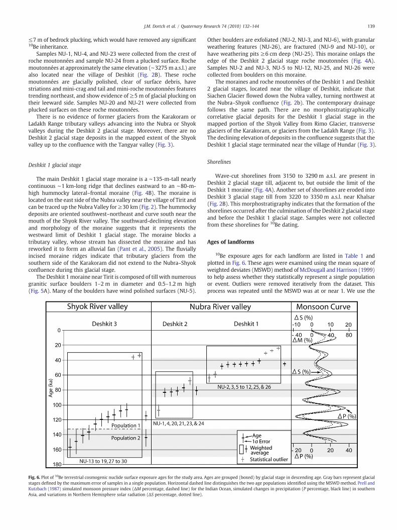
Ages of landforms
10Be exposure ages for each landform are listed in Table 1 andplotted in Fig. 6. These ages were examined using the mean square ofweighted deviates (MSWD)method of McDougall and Harrison (1999)to help assess whether they statistically represent a single populationor event. Outliers were removed iteratively from the dataset. Thisprocess was repeated until the MSWD was at or near 1. We use the
ges are grouped (boxed) by glacial stage in descending age. Gray bars represent glacialne distinguishes the two age populations identified using the MSWD method. Prell andndian Ocean, simulated changes in precipitation (P percentage, black line) in southern
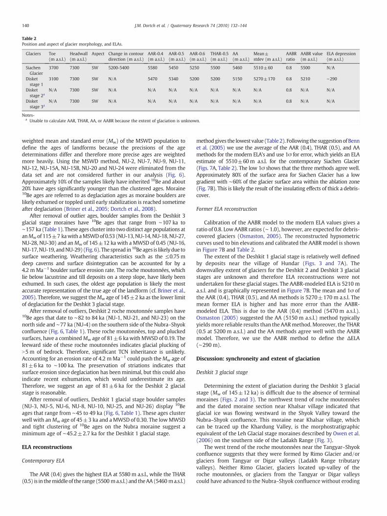
Table 2Position and aspect of glacier morphology, and ELAs.
Glaciers Toe(m a.s.l.)
Headwall(m a.s.l.)
Aspect Change in contourdirection (m a.s.l.)
AAR-0.4(m a.s.l.)
AAR-0.5(m a.s.l.)
AAR-0.6(m a.s.l.)
THAR-0.5(m a.s.l.)
AA(m a.s.l.)
Mean±stdev (m a.s.l.)
AABRratio
AABR value(m a.s.l.)
ELA depression(m a.s.l.)
SiachenGlacier
3700 7300 SW 5200-5400 5580 5450 5250 5500 5460 5510±60 0.8 5500 N/A
Disketstage 1
3100 7300 SW N/A 5470 5340 5200 5200 5150 5270±170 0.8 5210 ∼290
Disketstage 2a
N/A 7300 SW N/A N/A N/A N/A N/A N/A N/A 0.8 N/A N/A
Disketstage 3a
N/A 7300 SW N/A N/A N/A N/A N/A N/A N/A 0.8 N/A N/A
Notes-a Unable to calculate AAR, THAR, AA, or AABR because the extent of glaciation is unknown.
140 J.M. Dortch et al. / Quaternary Research 74 (2010) 132–144
weighted mean and standard error (Mw) of the MSWD population todefine the ages of landforms because the precisions of the agedeterminations differ and therefore more precise ages are weightedmore heavily. Using the MSWD method, NU-2, NU-7, NU-9, NU-11,NU-12, NU-15A, NU-15B, NU-20 and NU-24 were eliminated from thedata set and are not considered further in our analysis (Fig. 6).Approximately 10% of the samples likely have inherited 10Be and about20% have ages significantly younger than the clustered ages. Moraine10Be ages are referred to as deglaciation ages as moraine boulders arelikely exhumed or toppled until early stabilization is reached sometimeafter deglaciation (Briner et al., 2005; Dortch et al., 2008).
After removal of outlier ages, boulder samples from the Deshkit 3glacial stage moraines have 10Be ages that range from ∼107 ka to∼157 ka (Table 1). These ages cluster into twodistinct age populations atanMwof 115±7 kawith aMSWDof 0.53 (NU-13, NU-14, NU-18, NU-27,NU-28, NU-30) and anMw of 145±12 ka with a MWSD of 0.45 (NU-16,NU-17,NU-19, andNU-29) (Fig. 6). The spread in 10Be ages is likelydue tosurface weathering. Weathering characteristics such as the ≤0.75 mdeep caverns and surface disintegration can be accounted for by a4.2 mMa−1 boulder surface erosion rate. The roche moutonnées, whichlie below lacustrine and till deposits on a steep slope, have likely beenexhumed. In such cases, the oldest age population is likely the mostaccurate representation of the true age of the landform (cf. Briner et al.,2005). Therefore, we suggest theMw age of 145±2 ka as the lower limitof deglaciation for the Deshkit 3 glacial stage.
After removal of outliers, Deshkit 2 roche moutonnée samples have10Be ages that date to ∼82 to 84 ka (NU-1, NU-21, and NU-23) on thenorth side and ∼77 ka (NU-4) on the southern side of the Nubra–Shyokconfluence (Fig. 6, Table 1). These roche moutonnées, top and pluckedsurfaces, have a combinedMw age of 81±6 kawith MWSD of 0.19. Theleeward side of these roche moutonnées indicates glacial plucking ofN5 m of bedrock. Therefore, significant TCN inheritance is unlikely.Accounting for an erosion rate of 4.2 mMa−1 could push theMw age of81±6 ka to ∼100 ka. The preservation of striations indicates thatsurface erosion since deglaciation has beenminimal, but this could alsoindicate recent exhumation, which would underestimate its age.Therefore, we suggest an age of 81±6 ka for the Deshkit 2 glacialstage is reasonable.
After removal of outliers, Deshkit 1 glacial stage boulder samples(NU-3, NU-5, NU-6, NU-8, NU-10, NU-25, and NU-26) display 10Beages that range from ∼45 to 49 ka (Fig. 6, Table 1). These ages clusterwell with anMw age of 45±3 ka and a MWSD of 0.30. The lowMWSDand tight clustering of 10Be ages on the Nubra moraine suggest aminimum age of ∼45.2±2.7 ka for the Deshkit 1 glacial stage.
ELA reconstructions
Contemporary ELA
The AAR (0.4) gives the highest ELA at 5580 m a.s.l., while the THAR(0.5) is in themiddleof the range (5500 ma.s.l.) and theAA(5460 ma.s.l.)
methodgives the lowest value (Table2). Following the suggestionofBennet al. (2005) we use the average of the AAR (0.4), THAR (0.5), and AAmethods for the modern ELA's and use 1σ for error, which yields an ELAestimate of 5510±60m a.s.l. for the contemporary Siachen Glacier(Figs. 7A, Table 2). The low 1σ shows that the three methods agree well.Approximately 80% of the surface area for Siachen Glacier has a lowgradient with ∼60% of the glacier surface area within the ablation zone(Fig. 7B). This is likely the result of the insulating effects of thick a debris-cover.
Former ELA reconstruction
Calibration of the AABR model to the modern ELA values gives aratio of 0.8. Low AABR ratios (∼ 1.0), however, are expected for debris-covered glaciers (Osmaston, 2005). The reconstructed hypsometriccurves used to bin elevations and calibrated the AABRmodel is shownin Figure 7B and Table 2.
The extent of the Deshkit 1 glacial stage is relatively well definedby deposits near the village of Hundar (Figs. 3 and 7A). Thedownvalley extent of glaciers for the Deshkit 2 and Deshkit 3 glacialstages are unknown and therefore ELA reconstructions were notundertaken for these glacial stages. The AABR-modeled ELA is 5210 ma.s.l. and is graphically represented in Figure 7B. The mean and 1σ ofthe AAR (0.4), THAR (0.5), and AA methods is 5270±170 m a.s.l. Themean former ELA is higher and has more error than the AABR-modeled ELA. This is due to the AAR (0.4) method (5470 m a.s.l.).Osmaston (2005) suggested the AA (5150 m a.s.l.) method typicallyyieldsmore reliable results than the AARmethod.Moreover, the THAR(0.5 at 5200 m a.s.l.) and the AA methods agree well with the AABRmodel. Therefore, we use the AABR method to define the ΔELA(∼290 m).
Discussion: synchroneity and extent of glaciation
Deshkit 3 glacial stage
Determining the extent of glaciation during the Deshkit 3 glacialstage (Mw of 145±12 ka) is difficult due to the absence of terminalmoraines (Figs. 2 and 3). The northwest trend of roche moutonnéesand the dated moraine section near Khalsar village indicated thatglacial ice was flowing westward in the Shyok Valley toward theNubra–Shyok confluence. This moraine near Khalsar village, whichcan be traced up the Khardung Valley, is the morphostratigraphicequivalent of the Leh Glacial stage moraines described by Owen et al.(2006) on the southern side of the Ladakh Range (Fig. 3).
The west trend of the roche moutonnées near the Tangyar–Shyokconfluence suggests that they were formed by Rimo Glacier and/orglaciers from Tangyar or Digar valleys (Ladakh Range tributaryvalleys). Neither Rimo Glacier, glaciers located up-valley of theroche moutonnées, or glaciers from the Tangyar or Digar valleyscould have advanced to the Nubra–Shyok confluence without eroding

Fig. 8. Plot of recalculated 10Be terrestrial cosmogenic nuclide surface exposure agesfrom Seong et al. (2007) for the Skardu glacial stage. Ages are plotted in descending age.Horizontal dashed line distinguishes the two age populations identified using theMSWD method. The Deshkit 3 glacial stage Mw age (144.5±12.0 ka) and population-2are plotted for reference.
Fig. 7. SRTM DEM of the contemporary Siachen and Deshkit 1 stage glacial systems in the Nubra valley. Modern ELA's are marked by red and Deshkit 1 glacial stage marked by whitecontours. Contour interval is 500 m (black lines). B) Hypsometric curves for the contemporary Siachen Glacier and reconstructed for the Deshkit 1 glacial stage. The ELAs weredetermined using the AABR method and are marked on the hypsometric curves.
141J.M. Dortch et al. / Quaternary Research 74 (2010) 132–144
the roche moutonnées near Agham village (Fig. 3). It is likely thatglaciers from these sources contributed to the Deshkit 3 glacial stagedeposits. However, the preservation of the Deshkit 3 glacial stageroche moutonnées suggests that glaciers from these sources did notadvance to the Nubra–Shyok confluence during subsequent glacialstages.
Correlative deposits in the Nubra valley show that Siachen Glacieralso reached the village of Deshkit, ∼100 km from its present position.Glacial sediments of the Deshkit 3 glacial stage are ∼760 m higherthan those for the Deshkit 1 glacial stage in the Nubra–Shyokconfluence. The plug of sediment in the Shyok Valley near Khalsar(Fig. 2) indicates Siachen Glacier likely blocked or stalled the Shyoktrunk glacier, resulting in the development of large and well-formedcomposite moraines near the village of Khalsar.
Seong et al. (2007) suggested that Biafo, Panmah, and BaltoroGlaciers in the Central Karakoram of northern Pakistan advancedsynchronously during the Skardu glacial stage at MIS-6 (N150 km).Recalculation of Seong et al. (2007) 10Be ages using our methodsresults in the removal of 3 outliers. Using theMSWDmethod givesMw
ages of 112±10 ka and 157.0±13.0 ka with statistical indicators of0.97 and 1.26, respectively (Fig. 8, Table 1). The statistical indicator ishigh but values at or near one are acceptable (McDougall andHarrison, 1999). As with the Deshkit 3 glacial stage ages, the oldestage population represents the best minimum age approximation.
The Skardu glacial stageMw age of 157±13 ka has N50% overlap oferror with the Deshkit 3 glacial stage Mw age at 145±12 ka. However,the older MSWD populations in both the Disket 3 and Skardu glacial
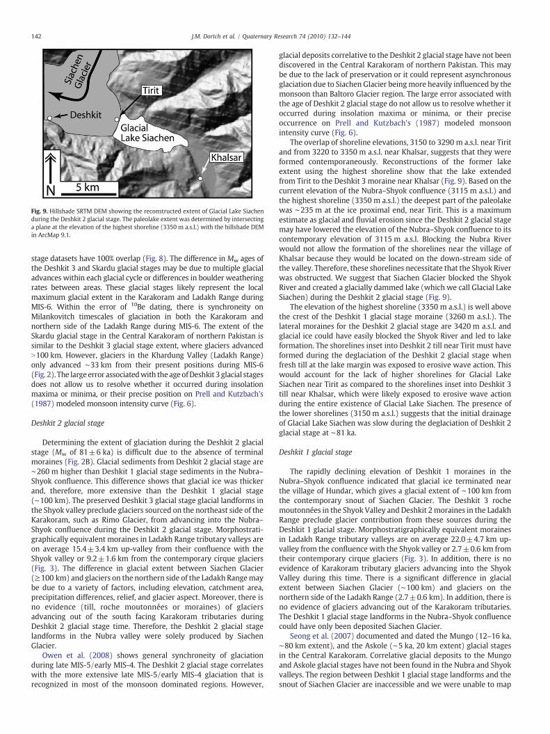
Fig. 9. Hillshade SRTM DEM showing the reconstructed extent of Glacial Lake Siachenduring the Deshkit 2 glacial stage. The paleolake extent was determined by intersectinga plane at the elevation of the highest shoreline (3350 m a.s.l.) with the hillshade DEMin ArcMap 9.1.
142 J.M. Dortch et al. / Quaternary Research 74 (2010) 132–144
stage datasets have 100% overlap (Fig. 8). The difference in Mw ages ofthe Deshkit 3 and Skardu glacial stages may be due to multiple glacialadvances within each glacial cycle or differences in boulder weatheringrates between areas. These glacial stages likely represent the localmaximum glacial extent in the Karakoram and Ladakh Range duringMIS-6. Within the error of 10Be dating, there is synchroneity onMilankovitch timescales of glaciation in both the Karakoram andnorthern side of the Ladakh Range during MIS-6. The extent of theSkardu glacial stage in the Central Karakoram of northern Pakistan issimilar to the Deshkit 3 glacial stage extent, where glaciers advancedN100 km. However, glaciers in the Khardung Valley (Ladakh Range)only advanced ∼33 km from their present positions during MIS-6(Fig. 2). The large error associatedwith theageofDeshkit 3 glacial stagesdoes not allow us to resolve whether it occurred during insolationmaxima or minima, or their precise position on Prell and Kutzbach's(1987) modeled monsoon intensity curve (Fig. 6).
Deshkit 2 glacial stage
Determining the extent of glaciation during the Deshkit 2 glacialstage (Mw of 81±6 ka) is difficult due to the absence of terminalmoraines (Fig. 2B). Glacial sediments from Deshkit 2 glacial stage are∼260 m higher than Deshkit 1 glacial stage sediments in the Nubra–Shyok confluence. This difference shows that glacial ice was thickerand, therefore, more extensive than the Deshkit 1 glacial stage(∼100 km). The preserved Deshkit 3 glacial stage glacial landforms inthe Shyok valley preclude glaciers sourced on the northeast side of theKarakoram, such as Rimo Glacier, from advancing into the Nubra–Shyok confluence during the Deshkit 2 glacial stage. Morphostrati-graphically equivalent moraines in Ladakh Range tributary valleys areon average 15.4±3.4 km up-valley from their confluence with theShyok valley or 9.2±1.6 km from the contemporary cirque glaciers(Fig. 3). The difference in glacial extent between Siachen Glacier(≥100 km) and glaciers on the northern side of the Ladakh Rangemaybe due to a variety of factors, including elevation, catchment area,precipitation differences, relief, and glacier aspect. Moreover, there isno evidence (till, roche moutonnées or moraines) of glaciersadvancing out of the south facing Karakoram tributaries duringDeshkit 2 glacial stage time. Therefore, the Deshkit 2 glacial stagelandforms in the Nubra valley were solely produced by SiachenGlacier.
Owen et al. (2008) shows general synchroneity of glaciationduring late MIS-5/early MIS-4. The Deshkit 2 glacial stage correlateswith the more extensive late MIS-5/early MIS-4 glaciation that isrecognized in most of the monsoon dominated regions. However,
glacial deposits correlative to the Deshkit 2 glacial stage have not beendiscovered in the Central Karakoram of northern Pakistan. This maybe due to the lack of preservation or it could represent asynchronousglaciation due to Siachen Glacier beingmore heavily influenced by themonsoon than Baltoro Glacier region. The large error associated withthe age of Deshkit 2 glacial stage do not allow us to resolve whether itoccurred during insolation maxima or minima, or their preciseoccurrence on Prell and Kutzbach's (1987) modeled monsoonintensity curve (Fig. 6).
The overlap of shoreline elevations, 3150 to 3290 m a.s.l. near Tiritand from 3220 to 3350 m a.s.l. near Khalsar, suggests that they wereformed contemporaneously. Reconstructions of the former lakeextent using the highest shoreline show that the lake extendedfrom Tirit to the Deshkit 3 moraine near Khalsar (Fig. 9). Based on thecurrent elevation of the Nubra–Shyok confluence (3115 m a.s.l.) andthe highest shoreline (3350 m a.s.l.) the deepest part of the paleolakewas ∼235 m at the ice proximal end, near Tirit. This is a maximumestimate as glacial and fluvial erosion since the Deshkit 2 glacial stagemay have lowered the elevation of the Nubra–Shyok confluence to itscontemporary elevation of 3115 m a.s.l. Blocking the Nubra Riverwould not allow the formation of the shorelines near the village ofKhalsar because they would be located on the down-stream side ofthe valley. Therefore, these shorelines necessitate that the Shyok Riverwas obstructed. We suggest that Siachen Glacier blocked the ShyokRiver and created a glacially dammed lake (which we call Glacial LakeSiachen) during the Deshkit 2 glacial stage (Fig. 9).
The elevation of the highest shoreline (3350 m a.s.l.) is well abovethe crest of the Deshkit 1 glacial stage moraine (3260 m a.s.l.). Thelateral moraines for the Deshkit 2 glacial stage are 3420 m a.s.l. andglacial ice could have easily blocked the Shyok River and led to lakeformation. The shorelines inset into Deshkit 2 till near Tirit must haveformed during the deglaciation of the Deshkit 2 glacial stage whenfresh till at the lake margin was exposed to erosive wave action. Thiswould account for the lack of higher shorelines for Glacial LakeSiachen near Tirit as compared to the shorelines inset into Deshkit 3till near Khalsar, which were likely exposed to erosive wave actionduring the entire existence of Glacial Lake Siachen. The presence ofthe lower shorelines (3150 m a.s.l.) suggests that the initial drainageof Glacial Lake Siachen was slow during the deglaciation of Deshkit 2glacial stage at ∼81 ka.
Deshkit 1 glacial stage
The rapidly declining elevation of Deshkit 1 moraines in theNubra–Shyok confluence indicated that glacial ice terminated nearthe village of Hundar, which gives a glacial extent of ∼100 km fromthe contemporary snout of Siachen Glacier. The Deshkit 3 rochemoutonnées in the Shyok Valley and Deshkit 2moraines in the LadakhRange preclude glacier contribution from these sources during theDeshkit 1 glacial stage. Morphostratigraphically equivalent morainesin Ladakh Range tributary valleys are on average 22.0±4.7 km up-valley from the confluence with the Shyok valley or 2.7±0.6 km fromtheir contemporary cirque glaciers (Fig. 3). In addition, there is noevidence of Karakoram tributary glaciers advancing into the ShyokValley during this time. There is a significant difference in glacialextent between Siachen Glacier (∼100 km) and glaciers on thenorthern side of the Ladakh Range (2.7±0.6 km). In addition, there isno evidence of glaciers advancing out of the Karakoram tributaries.The Deshkit 1 glacial stage landforms in the Nubra–Shyok confluencecould have only been deposited Siachen Glacier.
Seong et al. (2007) documented and dated the Mungo (12–16 ka,∼80 km extent), and the Askole (∼5 ka, 20 km extent) glacial stagesin the Central Karakoram. Correlative glacial deposits to the Mungoand Askole glacial stages have not been found in the Nubra and Shyokvalleys. The region between Deshkit 1 glacial stage landforms and thesnout of Siachen Glacier are inaccessible and we were unable to map
143J.M. Dortch et al. / Quaternary Research 74 (2010) 132–144
it, however no glacial landforms younger than Deshkit 1 glacial stagewere recognized on remote sensing imagery. Moreover, glacialdeposits correlative to the Deshkit 1 glacial stage (Mw of 45±3 ka)have not been discovered in the Central Karakoram of northernPakistan. This may be due to the lack of preservation, or it couldrepresent asynchronous glaciation. It is unlikely the monsoon wasresponsible for asynchroneity, as theDeshkit 1 glacial stage (45±3ka)likely occurredduring a timeofweak simulatedmonsoonpressure andprecipitation (Prell and Kutzbach (1987; Fig. 6).
Owen et al. (2008) suggest broad synchroneity of glacial maximaduring MIS-3 in many regions across the Himalayan mountain belt.The Deshkit 1 glacial stage, therefore, follows the temporal pattern ofglaciation that is recognized in most of the monsoon dominated,Transhimalaya, and westernmost Tibetan regions.
Conclusions
Glacial landforms for three glacial stages date to ∼45 ka (Deshkit 1glacial stage), ∼81 ka (Deshkit 2 glacial stage) and ∼145 ka (Deshkit 3glacial stage). Within error of 10Be dating, the Deshkit 1 and 2 glacialstages showsynchroneity of glaciationwith regionsprimarily controlledby monsoon precipitation during MIS-3 and the MIS 5/6 transition,respectively (cf. Owen et al., 2008). The timing of glaciation across theCentral Karakoram and Ladakh Range during MIS-6 is synchronous onMilankovitch timescales (and within error of each other), with theDeshkit 3 glacial stage dating to 145±12 ka (Mw) in the Nubra, Shyokand Khardung Valleys (Ladakh Range) and the recalculated 10Be ages ofSeong et al. (2007) for the Skardu glacial stage being 157±13 ka (Mw).Synchronous deposits for the Deshkit 1 and 2 glacial stages are notpresent in the central Karakoram.
The mean and standard error of the AAR, THAR, and AA methodsgive a contemporary ELA of 5510±60 m a.s.l. for the contemporarySiachen Glacier. The ELA of the Deshkit 1 glacial stage (at ∼45 ka) inthe Nubra and Shyok valleys based on the AARB method of Osmaston(2005) is 5210 m a.s.l., which results in a ΔELA of 290 m.
The large difference in glacial extent between Karakoram andLadakh Range is highlighted by the time equivalent Deshkit 1 toDeshkit 3 glacial stages (with Siachen Glacier extending N100 km) inthe Nubra valley and morphostratigraphic equivalent morainesextending 2.7±0.6 km (Deshkit 1), 9.2±1.6 km (Deshkit 2), and∼33 km (Deshkit 3) from the present glaciers in the Ladakh Rangetributary valleys. This illustrates the strong contrasts in patterns ofglaciation across adjacent mountain ranges in the Himalayan–Tibetanorogen and emphasizes the need for caution when correlatingregional glacial successions through high mountains.
Acknowledgments
JD thanks the Department of Geology, University of Cincinnati forsupporting this study as part of his doctoral research, and Sigma Xi,the American Alpine Club, and the University Research Counsel of theUniversity of Cincinnati for helping to fund this study; Byron Adamsfor helping to process samples during the early stages of this project,and Susan Ma for helping calculate our 10Be ages and recalculate agesfrom other studies. LAO andMWC thank the Department of Geology atUC for helping to fund fieldwork. Thanks to Professor Alan Gillespie,Dr. Balco and an anonymous reviewer for comments on an earlierversion of this paper.
References
Balco, G., Stone, J.O., Lifton, N.A., Dunai, T.J., 2008a. A complete and easily accessiblemeans of calculating surface exposure ages or erosion rates from 10Be and 26Almeasurements. Quaternary Geochronology 8, 174–195.
Balco, G., Briner, J., Finkel, R.C., Rayburn, J., Ridge, J.C., Schaefer, J.M., 2008b. Regionalberyllium-10 production rate calibration for late-glacial northeastern NorthAmerica. Quaternary Science Reviews 4, 93–107.
Benn, D.I., Lehmkuhl, F., 2000. Mass balance and equilibrium-line altitudes of glaciers inhigh mountain environments. Quaternary International 65 (66), 15–29.
Benn, D.I., Owen, L.A., 2002. Himalayan glacial sedimentary environments: a frameworkfor reconstructing and dating former glacial extents in high mountain regions.Quaternary International 97 (98), 3–26.
Benn, D.I., Owen, L.A., Osmaston, H.A., Seltzer, G.O., Porter, S.C., Mark, B., 2005.Reconstruction of equilibrium-line altitudes for tropical and sub-tropical glaciers.Quaternary International 138 (139), 8–21.
Bhutiyani, M.R., 2000. Sediment load characteristics of a proglacial stream of SiachenGlacier and the erosion rate in Nubra valley in the Karakoram Himalayas, India.Journal of Hydrology 227, 84–92.
Bookhagen, B., Thiede, R.C., Strecker, M.R., 2005. Late Quaternary intensified monsoonphases control landscape evolution in the northwest Himalaya. Geology 33, 149–152.
Bookhagen, B., Burbank, D.W., 2006. Topography, relief, and TRMM-derived rainfallvariations along the Himalaya. Geophysical Research Letters 33, L08405.
Briner, J.P., Kaufman, D.S., Manley, W.F., Finkel, R.C., Caffee, M.W., 2005. Cosmogenicexposure dating of late Pleistocene moraine stabilization in Alaska. GeologicSociety of America Bulletin 117, 1108–1120.
Brown, E.T., Bendick, R., Bourlés, D.L., Gaur, V., Molnar, P., Raisbeck, G.M., Yiou, F., 2003.Early Holocene climate recorded in geomorphological features in western Tibet.Palaeogeography, Palaeoclimatology, Palaeoecology 199, 141–151.
CGIAR-CSI, 2007, 2007. The CGIAR Consortium for Spatial Information. http://srtm.csi.cgiar.org/SELECTION/inputCoord.asp.
Chevalier, M.L., Ryerson, F.J., Tapponnier, P., Finkel, R.C., Van Der Woerd, J., Haibing, L.,Qing, L., 2005. Slip-rate measurements on the Karakoram Fault may imply secularvariations in fault motion. Science 307, 411–414.
Derbyshire, E., 1981. Glacier regime and glacial sediment facies: a hypotheticalframework for the Qinghai-Xizang Plateau. Proceedings of the Symposium onQinghai-Xizang (Tibet) Plateau Beijing China: Vol. 2—Geological and EcologicalStudies of Qinghai-Xizang Plateau. Science Press, Beijing, pp. 1649–1656.
Desilets, D., Zreda, M., 2003. Spatial and temporal distribution of secondary cosmic-raynucleon intensities and applications to in-situ cosmogenic dating. Earth andPlanetary Science Letters 206 (1–2), 21–42.
Dortch, J., Owen, L.A., Haneberg, W.C., Caffee, M.W., Dietsch, C., Kamp, D.U., 2008.Nature and timing of large-landslides in the Himalaya and Transhimalaya ofnorthern India. Quaternary Science Reviews 28, 1037–1054.
Dortch, J.M., Owen, L.A., Caffee, M.W., 2009. Late Quaternary glaciation and ELAvariations of the McKinley River region, central Alaska Range. Boreas 39, 223–246.doi:10.1111/j.1502-3885.2009.00121.
Dunlap, W.J., Weinberg, R.F., Searle, M.P., 1998. Karakoram fault zone rocks cool in twophases. Geological Society of London 155, 903–912.
Gasse, F., Fontes, J.C., Van Campo, E., Wei, K., 1996. Holocene environmental changesin Bangong Co basin (Western Tibet). Part 4: discussion and conclusions.Paleogeography, Paleoclimatology, Paleoecology 120, 79–92.
Hewitt, K., 1989. The altitudinal organization of Karakoram geomorphic processes anddepositional environments. Zeitschrift für Geomorphologie 76, 9–32.
Kohl, C.P., Nishiizumi, K., 1992. Chemical isolation of quartz for measurements of in-situ-produced cosmogenic nuclides. Geochimica et Cosmochimica Acta 56,3583–3587.
Kulkarni, A.V., 1992. Mass balance of Himalayan glaciers using AAR and ELA methods.Journal of Glaciology 38, 101–104.
Ma, X.Z., Li, Y.K., Bourgeois, M., Caffee, M.W., Elmore, D., Granger, D., Muzikar, P., Smith, P.,2007. Webcn: a web-based computation tool for in situ-produced cosmogenicnuclides. Nuclear Instruments & Methods in Physics Research Section B-BeamInteractions with Materials and Atoms 259, 646–652.
McDougall, I., Harrison, T.M., 1999. Geochronology and Thermochronology by the40Ar/39Ar method, Second edition. Oxford University Press, Oxford. 269 pp.
Müller, F., 1980. Present and late Pleistocene equilibrium line altitudes in the MountEverest region: an application of the glacier inventory. World Glacier Inventory126, 75–94.
NASA, 2007. National Aeronautics and Space Administration Land Processes DistributedActive Archive Center, Earth Observing Data Gateway. http://edcimswww.cr.usgs.gov/pub/imswelcome/.
Nash, 2007. ReadArcGrid: histograms elevations read from datasets in ASCII AcGridformat. Also calculates dimensionless hypsometric curve. http://homepages.uc.edu/~nashdb/.
Nishiizumi, K., Wintterer, E.L., Kohl, C.P., Klein, J., Middleton, R., Lal, D., Arnold, J.R., 1989.Cosmic ray production of 10Be and 26Al in quartz from glacially polished rocks.Journal of Geophysical Research 94, 17907–17915.
Nishiizumi, K., Imamura, M., Caffee, M.W., Southon, J.R., Finkel, R.C., McAninch, J., 2007.Absolute calibration of 10Be AMS standards. Nuclear Instruments & Methods inPhysics Research—Beam Interactions with Materials and Atoms 258B, 403–413.
Osmaston, H., 2005. Estimates of glacier equilibrium line altitudes by the area×altitude,the area×altitude balance ration and the area×altitude balance index methodsand their validation. Quaternary International 138–139, 22–31.
Owen, L.A., Gualtieri, L., Finkel, R.C., Caffee, M.W., Benn, D.I., Sharma, M.C., 2001.Cosmogenic radionuclide dating of glacial landforms in the Lahul Himalaya,Northern India: defining the timing of Late Quaternary glaciation. Journal ofQuaternary Science 16, 555–563.
Owen, L.A., Ma, H., Derbyshire, E., Spencer, J.Q., Barnard, P.L., Nian, Z.Y, Finkel, R.C.,Caffee, M.W., 2003. The timing and style of Late Quaternary glaciation in the La Jimountains NE Tibet: evidence for restricted glaciation during the latter part of theLast Glacial. Zeitschrift für Geomorphology 130, 263–276.
Owen, L.A., Benn, D.I., 2005. Equilibrium-line altitudes for the Last Galial Maximum forthe Himalaya and Tibet: an assessment and evaluation of results. QuaternaryInternational 138 (139), 55–78.
144 J.M. Dortch et al. / Quaternary Research 74 (2010) 132–144
Owen, L.A., Caffee, M.W., Bovard, K.R., Finkel, R.C., Sharma, M.C., 2006. Terrestrialcosmogenic nuclide surface exposure dating of the oldest glacial successions in theHimalayan orogen: Ladakh Range, northern India. Geological Society of America,Bulletin 118, 383–392.
Owen, L.A., Caffee, M.W., Finkel, R.C., Seong, B.Y., 2008. Quaternary glaciations of theHimalayan–Tibetan orogen. Journal of Quaternary Science 23, 513–531.
Owen, L.A., Robinson, R., Benn, D.I., Finkel, R.C., Davis, N.K., Yi, C., Putkonen, J., Li, D.,Murray,A.S., 2009. Quaternary glaciation of Mount Everest. Quaternary Science Reviews 28,1412–1433.
Pant, R.K., Phadtare, N.R., Chamyal, L.S., Juyal, N., 2005. Quaternary deposits in Ladakhand Karakoram Himalaya: a treasure trove of the paleoclimate records. CurrentScience 88, 1789–1798.
Phartiyal, B., Sharma, A., Upadhyay, R., Ram-Awatar, Sinha, A.K., 2005. Quaternarygeology, tectonics and distribution of palaeo- and present flivio/glacio lacustrinedeposits in Ladakh, NW Indian Himalaya—a study based on field observations.Geomorphology 65, 241–256.
Phillips, W.M., Sloan, V.F., Shroder Jr., J.F., Sharma, P., Clarke, M.L., Rendell, H.M., 2000.Asynchronous glaciation at Nanga Parbat, northwestern Himalaya Mountains,Pakistan. Geology 28, 431–434.
Prell, W.L., Kutzbach, J.E., 1987. Monsoon variability over the past 150, 000 years.Journal of Geophysical Research 92, 8411–8425.
PRIME Laboratory, 2007. PRIME laboratory rock age calculator. https://www.physics.purdue.edu/ams/rosetest/Rkversion1/rockpara.php.
PRIME Laboratory, 2010. Important note concerning 10Be results. http://www.physics.purdue.edu/primelab/News/news0907.php.
Richards, B.W.M., Benn, D.I., Owen, L.A., Rhodes, E.J., Spencer, J.Q., 2000a. Timing of LateQuaternary glaciations south of Mount Everest in the Khumbu Himal, Nepal.Geological Society of American Bulletin 112, 1621–1632.
Richards, B.W.M., Owen, L.A., Rhodes, E.J., 2000b. Timing of Late Quaternaryglaciations in the Himalayas of northern Pakistan. Journal of Quaternary Science15, 283–297.
Searle, M.P., Dewey, J.F., Dunlap, W.J., Strachan, R.A., Weinberg, R.F., 1998. Transpres-
sional tectonics along the Karakoram fault zone, northern Ladakh; constraints onTibetan extrusion. Geological Society Special Publications; Continental Transpres-sional and Transtensional Tectonics 135, 307–326.
Searle, M.P., Richard, J.P., 2007. Relationships between right–lateral shear along theKarakoram fault andmetamorphism, magmatism, exhumation and uplift: evidencefrom the K2-Gasherbrum, Pangong ranges, north Pakistan and Ladakh. GeologicalSociety of London 164, 439–450.
Seong, Y.B., Owen, L.A., Bishop, M.P., Bush, A., Clendon, P., Copland, L., Finkel, R., Kamp, U.,Shroder Jr., J.F., 2007. Quaternary glacial history of the Central Karakoram. QuaternaryScience Reviews 26, 3384–3405.
Seong, Y.B., Bishop, M.P., Bush, A., Clendon, P., Copland, P., Finkel, R., Kamp, U., Owen, L.A.,Shroder, J.F., 2008. Landforms and landscape evolution in the Skardu, Shigar andBraldu Valleys, Central Karakoram Mountains. Geomorphology 103, 251–267.
Seong, Y.B., Owen, L.A., Yi, C., Finkel, R.C., 2009. Quaternary glaciation of Muztag Ata andKongur Shan: evidence for glacier response to rapid climate changes through the LateGlacial andHolocene inwesternmostTibet.Geological Society of AmericaBulletin121,348–365.
Shi, Y., Yu, G., Liu, X., Li, B., Yao, T., 2001. Reconstruction of the 30–40 ka BP enhancedIndian monsoon climate based on geological records from the Tibetan Plateau.Paleogeography, Paleoclimatology, Paleoecology 169, 69–83.
Stone, J.O., 2000. Air pressure and cosmogenic isotope production. Journal ofGeophysical Research 105, 23753–23759.
Zech, W., Glaser, B., Ni, A., Petrov, M., Lemzin, I., 2000. Soil as indicators of the PleistoceneandHolocene landscapehistory: AlayRange (Khyrgstan). Quaternary International 65(66), 161–170.
Zech, W., Glaser, B., Abramowski, U., Dittmar, C., Kubik, P.W., 2003. Reconstruction ofthe Late Quaternary Glaciation of the Macha Khola valley (Gorkha Himal, Nepal)using relative and absolute (14C, 10Be, dendrochronology) dating techniques.Quaternary Science Reviews 22, 2253–2265.
Zech, R., Abramowski, U., Glaser, B., Sosin, P., Kubik, P.W., Zech, W., 2005. LateQuaternary glacier and climate history of the Pamir Mountains derived fromcosmogenic 10Be exposure ages. Quaternary Research 64, 212–220.