
Combined instrument transformer PVA 123a/PVA 145a Installation ...

Flood Risk Management in Scotland: 2018 Consultation on Potentially Vulnerable Areas
Consultation outcome report

2
Contents
Executive summary
1 Introduction ............................................................................................................................ 6
2 Analysis of responses ........................................................................................................... 9
Climate change and flooding .................................................................................................... 9
National Flood Risk Assessment method ................................................................................. 12
Proposed Potentially Vulnerable Areas 2018 ........................................................................... 15
Local Plan Districts .................................................................................................................. 19
Future Consultation Arrangements .......................................................................................... 21
3 Other national themes ........................................................................................................... 23
4 Conclusion and next steps ................................................................................................... 26
Annex 1: List of respondents
Annex 2: Map of Local Plan Districts
Annex 3: Map of Potentially Vulnerable Areas

3
Executive summary
Flood risk management planning is a matter of both national and local importance. Our aim
is to ensure that national efforts of Responsible Authorities are targeted to areas of greatest
risk, and that these areas are informed by as much local knowledge of flooding as is
possible.
To help direct efforts to reduce flood risk, the Scottish Environment Protection Agency
(SEPA) identifies local catchments where significant risk exists now or is likely to occur in
the future. These are Potentially Vulnerable Areas which require the production of flood risk
management plans coordinating the activity of Responsible Authorities in reducing flood
risk. Scottish Ministers formally designate Potentially Vulnerable Areas, based on the
advice of SEPA and its consultation with partners and the public.
Potentially Vulnerable Areas are derived from the National Flood Risk Assessment, which is
updated and published every six years. The National Flood Risk Assessment takes into
account past, current and future flood risk, using recorded events, observations and
computer modelling. It considers flooding from rivers, the sea and from surface water.
Embedding climate change knowledge in flood risk management planning will ensure that
our efforts help communities, infrastructure and way of life to adapt to climate change.
Potentially Vulnerable Areas are a vital part of helping us to understand and prioritise
where coordinated and planned efforts could be of most benefit.
Since 2011, when Potentially Vulnerable Areas were first identified, SEPA and our partners
have been working hard to improve data and methods of flood risk assessment. As a result,
we now have new information. This has resulted in changes to the Potentially Vulnerable
Areas. Although it is a science and evidence-led process, feedback is important to sense
check our understanding, as there may be local impacts of which we are unaware. New
Potentially Vulnerable Areas have been added since 2011 due to an improved
understanding of risk, or because of future risk due to climate change, or land use change.
Some local catchments have been proposed for de-designation where our more recent data
shows less risk than the 2011 National Flood Risk Assessment. There have been boundary
adjustments to some Potentially Vulnerable Areas to better represent the distribution of risk
within them. Many Potentially Vulnerable Areas remain unchanged but our understanding
of the risk within them all has improved.
We consulted on the Potentially Vulnerable Areas from 1 May 2018 for a three month period
to make sure we have got it right. This provided an opportunity for members of the public
and our partners to provide us with feedback on the proposed changes.
As a consequence of the consultation, we have amended and added new Potentially
Vulnerable Areas. The broad support we had for the Local Plan Districts, the National Flood
Risk Assessment and the consultation arrangements up until 2021, means that we and our
partners can proceed with confidence to the next stages of flood risk management
planning.

4
Purpose
This document provides an analysis of the responses received to the Flood Risk Management in
Scotland – 2018 Consultation on Potentially Vulnerable Areas. It summarises the views we
received and explains the actions we are taking in response. In addition to informing our view on
Potentially Vulnerable Areas for 2021-2027, the consultation was also an important opportunity to
gather views on the retention of the Local Plan Districts and future consultation arrangements for
flood risk management. This document also describes how we carried out the consultation and
who we consulted with.
Summary of responses
In total we received 263 responses: 256 online responses and seven separate written responses.
We are grateful to individuals and organisations for considering the proposals and providing
feedback. Responses varied from detailed comments on Potentially Vulnerable Areas to others
that were brief and focused on a single theme.
Compared to the first consultation on Potentially Vulnerable Areas in 2011, there has been a
welcome 417% increase in the number of responses. This is likely to reflect the increased
awareness the public has of flood risk management planning in Scotland as well as the
strengthened partnership working between SEPA and Responsible Authorities achieved in
preparation of Scotland’s first Flood Risk Management Strategies in 2015.
We received general agreement from respondents on our proposals for new Potentially Vulnerable
Areas. Only 13% of respondents challenged areas we are proposing for designation. Similarly,
only 14% of respondents requested additional locations to be identified as Potentially Vulnerable
Areas. Respondents who disagreed with our proposals generally felt that the proposed Potentially
Vulnerable Areas were too broad and included areas not at flood risk. Respondents also provided
suggestions for new areas that they felt should be included. Their justification for including these
areas often reflected past experiences with flooding and requests were sometimes accompanied
by comments asking for more action by authorities to manage flood risk.
We received a good level of support for the National Flood Risk Assessment, the retention of the
14 Local Plan Districts, and for the planned consultation arrangements for the period 2018-2021.
We also received comments on a wide range of issues that, although not directly relevant to the
National Flood Risk Assessment or Potentially Vulnerable Areas, clearly illustrate areas of general
concern for how flood risk is managed in Scotland. This included concerns around the use of
dredging and maintenance of watercourses to manage flood risk, building on the floodplain and
insurance companies using SEPA flood maps to influence premiums. These issues are also
summarised in this report.

5
What SEPA has done in response to the consultation?
In taking account of the views received SEPA is proposing to amend one of the Potentially
Vulnerable Areas that we consulted on and identified two additional Potentially Vulnerable Areas.
The new areas identified are Kirkmichael (South Ayrshire Council) and Beauly (Highlands Council)
while the Potentially Vulnerable Area being amended is North Uist to include Baleshare (Comhairle
nan Eilean Siar). SEPA has already undertaken a number of actions based on information and
responses provided during the consultation, such as discussing these with relevant local
authorities. We will continue to engage with our stakeholders and ensure working together is
central to improving flood risk management in Scotland. Information provided on local flooding and
other issues will be discussed with local authorities as appropriate. No changes have been made
to the Local Plan District proposals or the Statement on Consultation Arrangements as a result of
feedback received.
What will happen next?
This consultation exercise has been an important part of the process for identifying Potentially
Vulnerable Areas. A revised set of Potentially Vulnerable Areas, amended as appropriate using the
views expressed during the consultation, will now be submitted to Scottish Ministers for approval.
Following this a final set of Potentially Vulnerable Areas will be published by SEPA in December
2018, alongside the updated National Flood Risk Assessment. The Flood Risk Management
(Scotland) Act 2009 requires that for each Potentially Vulnerable Area identified:
We will produce flood hazard and flood risk maps for the area. In fact, SEPA produces
maps with full national coverage, which are part of a rolling update programme;
We, in consultation with our partners, will set objectives and identify actions to address
flood risk. These will be published in SEPA’s Flood Risk Management Strategies for the
period 2022-2027;
Local Flood Risk Management Plans will be produced by lead local authorities; and,
Scottish Water will undertake an assessment of the risk of flooding from the sewerage
system.
SEPA will continually engage with our stakeholders to help deliver successful flood risk
management for Scotland. The National Flood Risk Assessment will now inform future Flood Risk
Management Strategies which will be published in December 2021.
Potentially Vulnerable Areas will be published on SEPA’s website by 22 December 2018.
The Statement of consultation arrangements will be published on SEPA’s website by 22 December
2018.

6
Chapter 1: Introduction
Background
The Flood Risk Management in Scotland: 2018 Consultation on Potentially Vulnerable Areas
opened on 1 May 2018 for three months. This document provides a summary of the consultation
exercise, views expressed by respondents and the action taken by SEPA in response to those
views.
The consultation process forms part of the work to review and update the 2011 National Flood Risk
Assessment, as required by the Flood Risk Management (Scotland) Act 2009. Our understanding
of flood risk is constantly improving and periodic reviews and updates are essential to ensure we
can effectively support flood risk management in Scotland.
Effective partnership working and engagement is central to how we deliver flood risk management.
This consultation on Potentially Vulnerable Areas is an example of how we can achieve successful
partnership working by incorporating local knowledge and information into the identification of
areas most at risk.
Summary of actions taken by SEPA to publish and consult on the
Potentially Vulnerable Areas
To promote the launch of the consultation, we published adverts in a number of publications both
in print and online including the Edinburgh Gazette, Daily Record, and The Metro. A digital
campaign using social media and website platforms was also developed as well as a radio
campaign broadcasting throughout Scotland. We provided all local authority flooding teams with
briefing packs with access to draft article templates and social media messages which they could
use to promote the consultation within their organisation and local area.
We also wrote letters to Scottish Water, Scottish Natural Heritage, the Environment Agency,
Cumbria County Council, Northumberland County Council, all Category 1 and 2 Respondersi,
(Scottish) Members of Parliament and Members of the Scottish Parliament.
Our Flooding Communications team circulated details of the consultation in a number of SEPA
publications including our bi-annual Development and Delivery newsletter, Flooding Gateway
newsletter and our quarterly Local Plan District Partnership e-bulletin.
We promoted the consultation to our other partners through the National Flood Management
iCategory 1 and 2 Responders are defined as part of the Civil Contingencies Act 2004 which seeks to
minimise disruption in the event of an emergency. Category 1 Responders are ‘core’ responders: local
authorities, police, fire and rescue services, ambulance service, NHS health boards, SEPA and the Maritime
and Coastguard Agency. Category 2 Responders are key co-operating responders in support of Category 1
Responders. These include gas and electricity companies, rail and air transport operators, harbour
authorities, telecommunications providers, Scottish Water, the Health and Safety Executive and NHS
National Services Scotland.

7
Group, Cross Border Advisory Group, Lead Local Authority Forum, Flood Risk Management Local
Advisory Groups and Local Plan District Partnerships.
Whilst it is SEPA’s statutory duty to prepare the National Flood Risk Assessment and identify
Potentially Vulnerable Areas, local authorities and others have important duties to manage flood
risk within them. To ensure the outputs of the assessment were a fair reflection of flood risk within
their areas we invited all 32 local authorities and other Responsible Authorities to attend one-to-
one workshops prior to the consultation.
Summary of consultation questions
Theme Consultation question
Climate change and flooding
Our future Flood Risk Management Strategies must take
account of climate change. Do you think that flooding is one
of the major climate change challenges Scotland will face in
the future?
National Flood Risk
Assessment methodology
Do you support or have any comments on the 2018 National
Flood Risk Assessment?
Identification of Potentially
Vulnerable Areas
Are there areas that have been identified as Potentially
Vulnerable Areas that shouldn’t be?
Are there areas that have not been identified as Potentially
Vulnerable Areas that should be?
Local Plan Districts
Local Plan Districts were consulted upon and agreed in 2011.
With minor adjustments, we intend to retain the 14 Local Plan
Districts. Do you support the retention of the 14 Local Plan
Districts?
Consultation Arrangements
Do you agree with the consultation arrangements outlined to
support the delivery of flood risk management planning in
Scotland? Please provide suggestions of alternative or
additional arrangements that you would like to see
undertaken.
Consultation responses and respondents
We would like to thank all organisations and individuals that participated in the consultation
processii. While the majority of responses followed the format of the online questionnaire, some
respondents submitted non-standard responses (such as emails or stand-alone documents).
Although not all of these addressed the consultation questions directly, wherever possible themes
were identified and these have been included in the analysis.
Some respondents also provided additional information in the form of photographs, images and
links to other studies. We have considered these alongside the relevant comments.
We received a total of 263 responses to the consultation. To aid analysis of responses,
iiUnless specified, when referring to ‘responses’ and ‘respondents’, we mean both organisational and
individual responses and respondents.
8
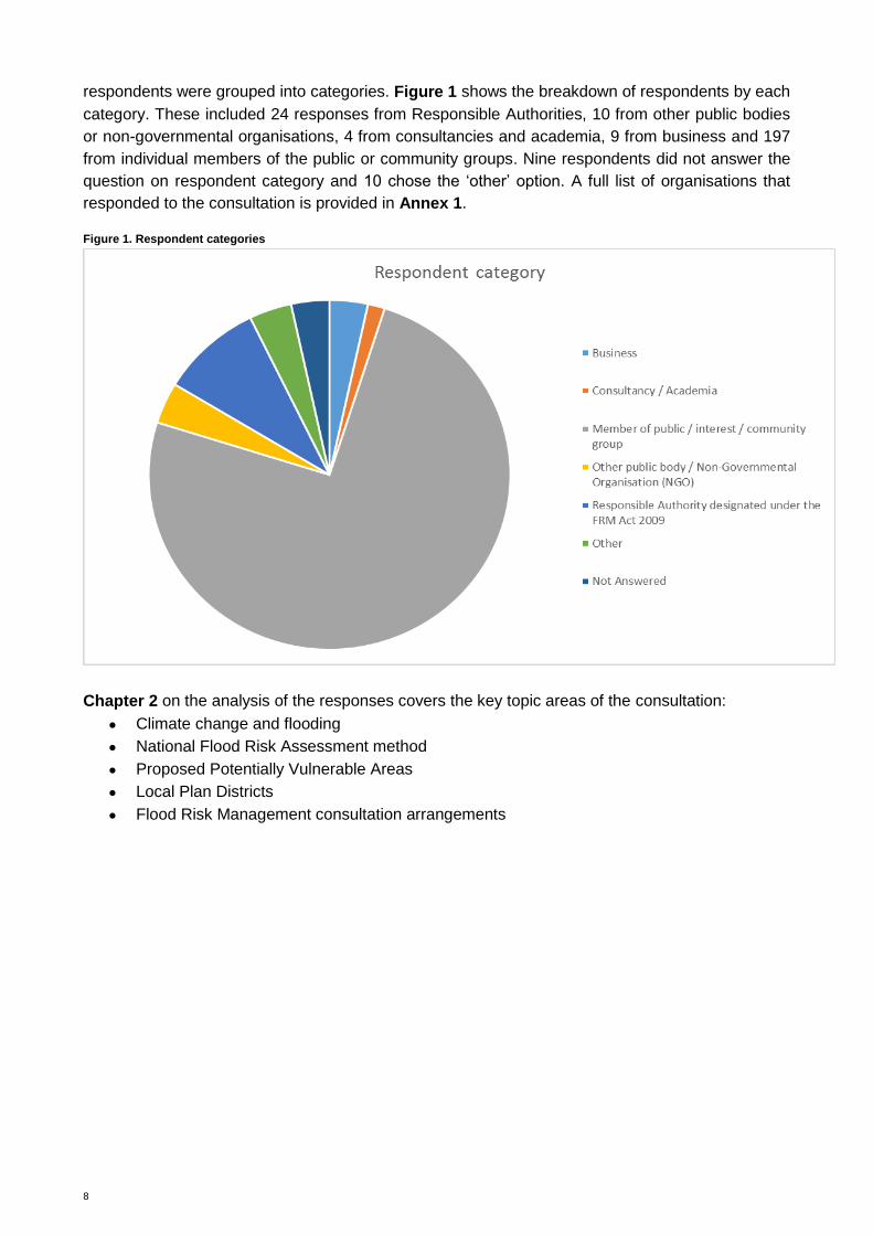
respondents were grouped into categories. Figure 1 shows the breakdown of respondents by each
category. These included 24 responses from Responsible Authorities, 10 from other public bodies
or non-governmental organisations, 4 from consultancies and academia, 9 from business and 197
from individual members of the public or community groups. Nine respondents did not answer the
question on respondent category and 10 chose the ‘other’ option. A full list of organisations that
responded to the consultation is provided in Annex 1.
Figure 1. Respondent categories
Chapter 2 on the analysis of the responses covers the key topic areas of the consultation:
Climate change and flooding
National Flood Risk Assessment method
Proposed Potentially Vulnerable Areas
Local Plan Districts
Flood Risk Management consultation arrangements

9
Chapter 2: Analysis of responses
This section of the consultation report looks at the responses to the specific questions asked.
Common additional themes identified are summarised in Chapter 3: Other national themes.
Climate change and flooding
Overview
There were 214 respondents (81%) who agreed that flooding is one of the major challenges
Scotland will face in the future and 21 respondents who disagreed. Nineteen respondents did not
express an opinion while two did not answer the question.
Of the 21 respondents who did not think that flooding was one of the major climate change
challenges Scotland will face in the future, the majority were members of the public or from a
community interest group. Figure 2 summarises the responses received.
Figure 2. Answers to question on climate change and flooding
What you said and our response
This section explains the main themes that have been raised through this question and SEPA’s
response.
Theme 1: Flooding is a major climate change challenge
Summary of responses
Most respondents acknowledged that climate change would lead to more extreme weather events,
increased rainfall and rising sea levels. Some respondents commented on the effect of warmer
temperatures on snowmelt and the risk of flash flooding. Other respondents remarked on a trend of
more frequent intense rainfall events during the summer months, increasing the risk of river and
Consultation question: Our future Flood Risk Management Strategies must take account of climate change. Do you
think that flooding is one of the major climate change challenges Scotland will face in the
future?

10
surface water flooding. Some responses remarked on the impacts of increased flood risk in relation
to the environment, historic environment and infrastructure.
Public bodies that responded to this question recognised that increased flood risk because of
climate change presents a challenge for their organisations. Comments were received about the
need to be better prepared for example, by using property-level resilience measures or developing
adaptation plans.
Scottish Natural Heritage discussed climate change adaptation as a key component of their
corporate plan and provided a link to their publication Climate Change and Nature in Scotlandiii,
while the Loch Lomond and The Trossachs National Park Authority discussed how climate change
and flooding is included in their National Park Partnership Plan.
A few respondents believed that there was a lack of consensus on climate change trends in
Scotland. In particular, a few responses highlighted the potential for increased periods of drier
weather as well as wetter weather.
SEPA response
Key long-term climate change trends for Scotland indicate that the weather may become more
variable. Typical summers are anticipated to be warmer and drier and typical winter/autumn
periods milder and wetter. Sea levels are also expected to continue to rise. We can expect to see
increased frequency and intensity of extreme precipitation events, an increase in summer
heatwaves, extreme temperatures and drought and a reduced occurrence of frost and snowfall.
The 2018 National Flood Risk Assessment considers the flooding impact associated with climate
change using scenarios based on the UK Climate Projections 2009 (UKCP09) analysis. SEPA
recognises that the impacts of climate change will depend on regional variation as well as the local
characteristics of an area.
The next major update to UK climate change understanding will be UK Climate Projections 2018
(UKCP18) which are expected to be published in November 2018. When the updated climate
change projections are made available, SEPA will begin work to take them into account in our
flood hazard mapping which will help to inform future flood risk management activities.
Understanding the impacts of climate change on flood risk will help us to inform sustainable flood
risk management plans to manage both current and future flood risk.
Theme 2: Not just climate change which increases flood risk
Summary of responses
Many respondents believed that climate change was only one of a combination of factors
increasing flood risk in Scotland and we received many comments on other trends that contribute
to flood risk.
Many respondents were concerned about the potential for flooding to be exacerbated by
development on the floodplain.
Other concerns included: field drains being used to remove water from agricultural land into
iii https://www.nature.scot/climate-change-and-nature-scotland

11
watercourses, poor clearance and maintenance of watercourses and drainage systems and an
increase in impermeable hard surfaces.
SEPA response
SEPA acknowledges that a variety of factors is likely to exacerbate the impact of flooding in the
future. In addition to climate change this includes demographic change, changes in land use and
other societal changes.
SEPA is a key agency in the land use planning process in Scotland and works to ensure it delivers
sustainable flood risk management. This includes ensuring inappropriate development is avoided
in areas at medium to high flood risk. Furthermore, we are in the process of developing a Flooding
Strategy that describes these wider influences on flood risk management and how Scotland can
adapt to a future with higher sea levels and where rainfall is likely to be more intense and frequent.

12
National Flood Risk Assessment method
Overview
There were 153 respondents (58%) who expressed support for the National Flood Risk
Assessment method. Twenty-seven respondents did not support the method, while 71 did not
express an opinion and five did not answer the question. Figure 3 summaries the responses
received.
Figure 3. Answers to question on the National Flood Risk Assessment method
What you said and our response
This section explains the main themes that have been raised through this question and SEPA’s
response.
Theme 1: Support for the assessment
Summary of responses
There was strong support for the National Flood Risk Assessment method. This included support
for the assessment taking account of: more influencing factors which can be locally significant,
especially in rural communities; inclusion of community scale impacts; inclusion of climate change
impacts and the improved representation of building footprints. There was also an
acknowledgement from respondents that this has been a collaborative process which has allowed
the national perspective to be translated to a local level.
SEPA response
SEPA welcomes the support for the National Flood Risk Assessment method. Our understanding
of flood risk is constantly developing and it is not a static field of work. A periodic review is
essential to ensure we effectively support flood risk management in Scotland. The Flood Risk
Management (Scotland) Act 2009 requires SEPA to review and update the assessment every six
years. The National Flood Risk Assessment will also be updated for the preparation of Flood Risk
Management Strategies to be published in 2021.
Consultation question: Do you support or have any comments on the 2018 National Flood Risk Assessment method?

13
Theme 2: Reasons for not supporting
Summary of responses
Respondents who did not support the National Flood Risk Assessment method gave the following
reasons:
Concerns that flooding issues outwith Potentially Vulnerable Areas would not be
addressed;
Concerns that the assessment does not incorporate a consideration of potential
development sites;
Concerns that flood protection schemes have not been considered;
Concerns that there has been insufficient consideration of local knowledge;
Concerns that the assessment focus is on larger urban settlements and misses smaller
rural communities; and
Concerns that the scale of the assessment has meant areas that have not flooded are
included in Potentially Vulnerable Areas.
SEPA response
Concerns regarding flooding outwith a Potentially Vulnerable Area
Potentially Vulnerable Areas identify areas of nationally significant flood risk. There will always be
areas outside Potentially Vulnerable Areas that still flood and need action. Over 90% of homes and
businesses at risk in Scotland are within Potentially Vulnerable Areas and Responsible Authorities
are aware that flood risk management is not limited to these areas. However, locations outside of
Potentially Vulnerable Areas generally do not require the coordinated multi-agency response often
needed to manage flooding within Potentially Vulnerable Areas.
Does not consider potential development sites
The 2018 National Flood Risk Assessment does not deal with planned development sites as
detailed in Local Development Plans. SEPA will respond to site-specific Flood Risk Assessments
on a case-by-case basis to prevent development which would have a significant probability of
being affected by flooding or would increase the probability of flooding elsewhere. SEPA will use
the outputs of the 2018 National Flood Risk Assessment as additional information when
responding to all Local Development Plans and individual planning applications.
Consideration of flood protection schemes
Our current flood hazard maps represent an undefended scenario except in areas where a more
detailed study has been incorporated which includes consideration of a flood protection scheme.
This means that the majority of formal flood protection schemes have been taken into account
within the National Flood Risk Assessment based on current understanding of their effectiveness.
Lack of local knowledge
During the process to identify Potentially Vulnerable Areas, we held workshops with local
authorities in Scotland and took proposals to local advisory groups. These workshops were an
opportunity for local authority flood officers and others to contribute local knowledge to inform our
decision-making process. The consultation provided an opportunity for other organisations and
members of the public to comment on how our proposals could be improved. As a consequence,
we feel the balance is right between taking forward a strategic national assessment and taking
account of local issues.

14
Inclusion of small rural settlements
The 2018 National Flood Risk Assessment method has been amended since 2011 to more
explicitly consider and represent remote and rural communities.
A wider range of community facilities were considered, representing the many services and
activities which come together to allow a community to prosper. These included libraries, courts,
job centres and other civic services. A community scale element has been incorporated in the
assessment alongside the risk to community facilities to identify locations where the functionality of
a community is compromised by the proportion of properties at risk.
Scale of assessment
Potentially Vulnerable Areas are local catchments within which there is significant flood risk. This
does not mean that everywhere in a Potentially Vulnerable Area is at risk of flooding.

15
Proposed Potentially Vulnerable Areas 2018
We asked two questions about identifying Potentially Vulnerable Areas. The first question invited
respondents to tell us where they disagreed with our proposed identification of a Potentially
Vulnerable Area. The second question asked respondents to identify other areas that they thought
should be Potentially Vulnerable Areas.
We also gave respondents the option to comment in detail on a particular Potentially Vulnerable
Area. Up to 10 specific areas could be commented on via the online consultation questionnaire. If
a respondent wanted to comment on more than 10 then they were requested to contact SEPA.
These comments were reviewed to determine whether the respondent supported the proposal to
(de-) designate the Potentially Vulnerable Area.
Overview
There were 72 responses to this question. Thirty-four respondents (13%) identified areas that they
considered should not be a Potentially Vulnerable Area. The rest of the respondents either did not
challenge our proposed Potentially Vulnerable Areas or did not express an opinion.
Some respondents to this question identified areas they believed should be identified as
potentially vulnerable. These responses were analysed under the next question. Figure 4 provides
a summary of the responses received in relation to areas that have been identified as potentially
vulnerable that should not be.
Figure 4. Answer to question on areas which should not be a Potentially Vulnerable Area
What you said and our response
This section explains the main themes that have been raised through this question and SEPA’s
response.
Only 13% of respondents challenged the proposed identification of Potentially Vulnerable Areas.
These responses fall into two main themes which are discussed below. The rationale provided in
the responses that challenged identification of Potentially Vulnerable Areas tended to question the
Consultation question: Are there areas that have been identified as Potentially Vulnerable Areas that should not be?

16
likely extent of flooding in the proposed area or was of the view that the scale of the area was too
large and not sufficiently locally-detailed. No objections were received from Responsible
Authorities.
Theme 1: Elevated areas within Potentially Vulnerable Areas
Summary of responses
A number of respondents pointed out that elevated areas (for example, hills) have been included
within the Potentially Vulnerable Area even though these areas are not at risk of flooding.
SEPA response
Potentially Vulnerable Areas are local catchments where flooding is considered to be nationally
significant and are identified to help prioritise where further investment or coordinated action
between authorities is needed to reduce flood risk. These areas are based on local catchments as
it is within the context of the wider catchment that flooding can be best understood and managed.
Within these catchment units there will be some areas that are not at flood risk, including areas of
elevated topography.
Theme 2: Scale of Potentially Vulnerable Areas
Summary of responses
We received a number of comments on the scale of Potentially Vulnerable Areas. Many
respondents believed that Potentially Vulnerable Areas were too large and that not all areas within
them are at risk of flooding. Some respondents identified specific areas within a Potentially
Vulnerable Area that had not experienced flooding. Some respondents also expressed concern
about whether being located within a Potentially Vulnerable Area would affect their home
insurance premiums or the value of their property.
SEPA response
As explained above in regard to elevated areas being included within Potentially Vulnerable Areas,
we have used catchment units as the basis for identifying where the potential impact of flooding is
greatest. Within these catchments are areas at significant flood risk and others (for example, areas
of elevated ground) that are not. However, it is within the context of catchments that flooding is
often best understood and managed.
The scale of Potentially Vulnerable Areas is intentionally quite broad to enable this catchment
approach to manage flooding. The Potentially Vulnerable Areas are not tools to identify individual
properties at risk and we will continue to advise insurance companies against using Potentially
Vulnerable Areas as a basis for influencing home insurance premiums.

17
Overview
There were 45 responses to this question. Thirty-seven respondents (14%) suggested additional
locations to be included as a Potentially Vulnerable Area. The rest of the respondents either did
not think there were areas that should be a Potentially Vulnerable Area or did not express an
opinion. Figure 5 summarises the responses to the question that invited respondents to identify
new Potentially Vulnerable Areas.
Figure 5. Answer to question on identifying new locations for Potentially Vulnerable Areas
What you said and our response
This section explains the main themes that have been raised through this question and SEPA’s
response.
14% of respondents suggested additional areas that should be included as Potentially Vulnerable
Areas. Out of those, 33 respondents were specific about the area they considered should be
designated. The remaining respondents made general comments on broad areas that they
believed should be designated but they did not provide sufficient information to enable us to
identify the relevant catchment units.
The primary reason for respondents proposing additional locations to be designated as a
Potentially Vulnerable Area is due to local knowledge or experience of flooding.
Theme 1: Local flooding
Summary of responses
Most respondents answering ‘yes’ to this question described local flooding as having occurred in
the location they wanted to see designated a Potentially Vulnerable Area. Some respondents
described a particular flood event they had witnessed or gave a more general comment that they
believed the area to be at flood risk. Other respondents raised issues around inadequate drainage
or land development that could exacerbate flood risk. Some of the respondents provided additional
Consultation question: Are there areas that have not been identified as Potentially Vulnerable Areas that should be?

18
information in support of their response including photographs of flooding and links to local flood
studies.
SEPA response
We value the input of local knowledge into the process to identify areas of significant flood risk.
The opportunity for organisations and individuals to comment on locations which they consider
should be designated as Potentially Vulnerable Areas is an important step in refining the outputs of
the National Flood Risk Assessment. Where reliable local information has been provided we have
used it to inform our decision-making.
We have reviewed each of the additional areas suggested by respondents. Our challenge is to
establish a plan-led and risk-based approach to flood risk management where the actions of
Responsible Authorities and others are coordinated in areas where the potential impacts are
greatest. This prioritisation inevitably means that not all areas at risk of flooding will be within
Potentially Vulnerable Areas. SEPA’s flood maps, which are not part of this consultation, more
accurately identify locations at risk of flooding in Scotland.
We have considered the extent of flooding and the potential impacts in the locations suggested by
respondents. As a consequence, and following discussion with the relevant local authorities, we
have altered our original proposals with the inclusion of two new Potentially Vulnerable Areas and
amendment of an existing Potentially Vulnerable Area. In the remaining areas suggested by
respondents our further assessment of the potential impact of flooding does not indicate they are
nationally significant. That does not mean that flooding is not a locally significant issue. We
understand that flooding is a distressing experience and we emphasise that being outwith a
Potentially Vulnerable Area does not preclude action to manage flood risk. There remains a duty
on Responsible Authorities to reduce and raise awareness of flood risk in all areas at risk.
Where appropriate, we have passed flood event information to the relevant local authority to aid
their local management of flood risk.
Comments made on particular Potentially Vulnerable Areas
We received additional comments on Potentially Vulnerable Areas that did not answer either of the
previous questions. These comments included:
Support for our decision to designate or remove a Potentially Vulnerable Area.
Information on local flood events and other issues within the Potentially Vulnerable Area
(e.g. permitted development).
Information on particular receptors at risk within the Potentially Vulnerable Area.
Calls for more management to mitigate a particular flooding issue.
Request from Scottish Canals to engage SEPA on where the canal network and supply
reservoirs could be a source of flood risk.
These comments have been considered as part of our decision-making on individual Potentially
Vulnerable Areas and, where appropriate, they have been passed to the relevant local authority.

19
Local Plan Districts
Overview
There were 136 respondents (52%) who expressed support for the retention of the 14 Local Plan
Districts. Ten respondents did not support the retention of the 14 Local Plan Districts, while 55 did
not express an opinion and 55 did not answer the question. Figure 6 provides a summary of the
responses received. Refer to Annex 2 for a map of the Local Plan Districts.
Figure 6. Answers to question on Local Plan Districts
What you said and our response
This section explains the main themes that have been raised through this question and SEPA’s
response.
Summary of responses
The majority of respondents agreed with the retention of the 14 Local Plan Districts, with a minor
boundary change at Nairn to better represent flood risk management in this area (between Local
Plan District 1, Highland and Argyll, and Local Plan District 5, Findhorn, Nairn and Speyside). This
minor adjustment is supported by the local authorities affected.
A small number of concerns were raised regarding the scale of the Local Plan Districts and the
sharing of information within and between them. Respondents wanted to make sure that there is a
clear understanding of how the delivery of actions in one area may affect another.
SEPA response
Based on the comments received, we intend to retain the 14 Local Plan Districts, with the minor
adjustment proposed for Nairn. Successful partnership working across the Local Plan Districts was
a key factor in producing the Flood Risk Management Strategies and Local Flood Risk
Management Plans in 2015 and 2016, respectively. Collectively, we have established a positive
platform for engagement and want to continue to improve this way of working within the existing
Local Plan Districts. The strong collaborative partnerships are reflected in the well-established
Consultation question: Local Plan Districts were consulted upon and agreed in 2011. With a minor adjustment, we
intend to retain the 14 Local Plan Districts. Do you support the retention of the 14 Local Plan
Districts?

20
advisory groups (national, local and cross-border) and in the development of our knowledge and
actions to reduce flood risk.
Sharing information between partners is fundamental to the successful management of flooding in
Scotland. SEPA will continue to fulfil a national role in helping connect partners and facilitate the
sharing of relevant information across Local Plan Districts. Similarly, the continued strengthening
of partnerships will be required to ensure that the implications of actions taken in one part of
Scotland are understood elsewhere.

21
Future Consultation Arrangements
Overview
There were 133 respondents (51%) who expressed support for the consultation arrangements.
Eighteen respondents did not support the proposed arrangements, while 50 did not express an
opinion and 55 did not answer the question. Figure 7 summaries the responses received.
Figure 7. Answers to question on consultation arrangements
What you said and our response
This section explains the main themes that have been raised through this question and SEPA’s
response.
Theme 1: Collaboration
Summary of responses
We received unanimous support from Responsible Authorities and other public bodies on the
proposed consultation arrangements. It was highlighted that the arrangements are consistent with
a collaborative approach to flood risk management. Some organisations expressed their desire to
remain engaged with SEPA in the flood risk management planning process.
SEPA response
Working together is key to flood risk management in Scotland and we will continue to collaborate
with partners to improve Scotland’s Flood Risk Management Strategies and Local Flood Risk
Management Plans. This partnership working and engagement is one of the key successes
achieved during the first flood risk management cycle (2010-2016) that must be further developed
for the production of the second Flood Risk Management Strategies and Local Flood Risk
Management Plans.
Consultation question: Do you agree with the consultation arrangements outlined to support the delivery of flood risk
management planning in Scotland? Please provide suggestions of alternative or additional
arrangements that you would like to see undertaken.

22
Theme 2: Method of consultation
Summary of responses
A few respondents to this question found the current consultation/future consultation arrangements
restrictive and/or inaccessible. One respondent discussed the need for alternative methods of
consultation, particularly to reach people who do not have access to a computer. Another
respondent felt that we should announce consultation launches on social media. There were also
comments made in relation to the structure of the current consultation and the need to ensure it is
aimed at the public.
SEPA response
We are greatly encouraged by the significant increase in the number of responses to this six-yearly
consultation exercise. SEPA will continue its efforts to improve the awareness and accessibility of
our flooding consultations to the public. Social media was used in launching this consultation on
Potentially Vulnerable Areas and it will continue to form part of the future engagement and
consultation arrangements for flood risk management planning.
Theme 3: Better engagement with the public
Summary of responses
There was a strong desire from some community groups to be better engaged in the consultation
process. There was a suggestion for SEPA to strengthen the proposed consultation arrangements
by identifying methods and approaches for engagement with local communities.
SEPA response
Communication and engagement is key to effective partnership working and collaboration.
Through the development of the flood risk management plans better engagement with the public
will be addressed, especially how SEPA and Responsible Authorities can improve this aspect of
engagement.

23
Chapter 3: Other national themes
Overview
This section outlines additional themes that were identified from the consultation responses.
Although they do not directly answer the questions asked, they are reflective of the issues that
concern many members of the public and we feel it is important they are summarised in this
consultation report.
What you said and our response
This section outlines the key recurring themes that were identified and our response.
Dredging
Summary of responses
Concerns were raised that dredging of waterways is not regularly being carried out by Responsible
Authorities and therefore flood risk is potentially increasing.
SEPA response
After a flood, dredging is often fiercely debated. Some people think dredging could have avoided or
limited the flood. Others disagree. The reality depends on the location and the size of the flood in
question. Under very particular conditions, in some locations, dredging can play a role in helping to
reduce the occurrence and impact of flooding. The effectiveness of dredging varies greatly and,
there are many circumstances where dredging will only have a localised, small and short-lived
effect. There are associated impacts on river stability and downstream flooding that must be
understood before any dredging is carried out. There can also be impacts on the environment and
protected habitats that need to be considered. Under more extreme flooding conditions, whether a
river has been dredged or not has little to no bearing on the flood extent. Other options for
managing rivers should also be considered.
Local authorities have a duty to maintain and clear watercourses if included in a schedule of local
works. A detailed local investigation is the most appropriate way of establishing the benefits and
associated impacts of dredging. Landowners manage their rivers using guidance from SEPA to
protect the natural environment. Dredging will affect the quality of the water environment and
requires authorisation from SEPA.
The location of dredging is always important and it should always be considered alongside other
actions to manage flood risk within the catchment.
The following guidance is available here: https://www.sepa.org.uk/regulations/water/guidance/

24
Clearance and maintenance of waterways
Summary of responses
Concerns were raised that clearance and maintenance of waterways is not regularly being carried
out leading to an increasing flood risk.
SEPA response
Local authorities have a duty to maintain and clear watercourses if included in a schedule of local
works. Schedules of works are available from local authorities. Landowners manage their rivers
using guidance from SEPA to protect the natural environment.
Insurance
Summary of responses
Concerns were raised that the Potentially Vulnerable Areas and National Flood Risk Assessment
would influence insurance companies to set higher premiums.
SEPA response
The Potentially Vulnerable Areas do not identify individual properties at risk of flooding – they are a
tool to help SEPA identify communities that would benefit from coordinated flood risk management
planning. Not all properties within Potentially Vulnerable Areas are at flood risk and similarly, some
properties outside of these areas are at flood risk.
The flood maps cannot be used by the insurance industry to interpret the flood risk of individual
properties and locations. This is included in the terms and conditions that all users agree to before
being able to view the map. We have an established relationship with representatives of the
insurance industry and they have been involved throughout the development of SEPA’s flood risk
management planning process.
Development on floodplains
Summary of responses
Concerns were raised that flooding in certain areas has been exacerbated by developments
(commercial and residential) on the floodplain.
SEPA response
As an independent advisor on flood risk to the land use planning process in Scotland, SEPA has a
duty to co-operate with planning authorities in the preparation of their development plans, as well
as a statutory role to provide flood advice for certain development management planning
applications. In providing advice to planning authorities on flood risk, our aim is to:
Effectively contribute to sustainable flood management by:
o ensuring development is avoided in areas at medium to high flood risk, from any
source, unless it accords with the risk framework in Scottish Planning Policy;
o exercising our planning functions with a view to reducing overall flood risk.
Support the delivery of Flood Risk Management Strategies; and
Promote the health and well-being of the people of Scotland by ensuring that proposed
development does not place communities and businesses at unacceptable flood risk.

25
Further information on SEPA’s role in land use planning can be found on our website:
www.sepa.org.uk.
Improved flood warning
Summary of responses
Several responses called for an improvement in flood warning systems.
SEPA response
Since our Flood Warning Strategy was published in 2012, considerable work has been undertaken
to improve our flood warning services. We have improved the accessibility and uptake of public
facing services such as Floodline and extended the reach and uptake of our daily flood guidance
statement which is issued to all civil contingency responders in Scotland. In partnership with the
Met Office, we have developed our forecasting technology and improved our understanding of
flood risk. We have invested in seven new flood warning schemes including new large coastal
schemes around the Moray and Solway coasts and the Firth of Forth and Tay.
In 2017 we published our Flood Warning Development Framework (2017-2021) which outlines,
with continuing support from the Scottish Government, how we will continue to maintain, improve
and broaden our service. It provides details of 14 additional flood warning schemes, new public
products we plan to introduce and how we will better use our own and others’, information to better
understand and communicate risk.
The Flood Warning Development Framework (2017-2021) can be found on our website:
www.sepa.org.uk.
26
Chapter 4: Conclusions and next steps
We greatly appreciate the time and effort taken by all respondents to our consultation on the
identification of Potentially Vulnerable Areas. We also welcome the significant increase in the
number of respondents compared to 2011 when we previously consulted on Potentially Vulnerable
Areas. The more local knowledge and detail we receive, the more confidence we have that our
efforts to reduce the impacts of flooding are well-directed.
We received a good level of support for the National Flood Risk Assessment. The 2018 National
Flood Risk Assessment has significantly improved upon the previous baseline of flood risk and
represents the best understanding yet of flood risk in Scotland. This in no small part reflects the
input from partners and the public to improve our underlying evidence.
We received general agreement from respondents on our proposals for new Potentially Vulnerable
Areas. Only 13% of respondents challenged areas we are proposing for designation. Similarly,
only 14% of respondents requested additional locations to be identified as Potentially Vulnerable
Areas.
We have considered the extent of flooding and the potential impacts in the locations suggested by
respondents. As a consequence, and following discussion with the relevant local authorities, we
have altered our original proposals with the inclusion of two new Potentially Vulnerable Areas and
the amendment of one Potentially Vulnerable Area. In the remaining areas suggested by
respondents, our further assessment of the potential impact of flooding in these locations does not
indicate they are nationally significant. That does not mean that flooding is not a locally significant
issue in the areas we have not included. We understand that flooding is a distressing experience
and we emphasise that being outwith a Potentially Vulnerable Area does not preclude action to
manage flood risk. There remains a duty on Responsible Authorities to reduce and raise
awareness of flood risk in all areas at risk.
We received good support for the retention of the 14 Local Plan Districts, as well as for the
planned consultation arrangements for the period 2018-2021.
We also received comments on a wide range of issues that, although not directly relevant to the
National Flood Risk Assessment or Potentially Vulnerable Areas, clearly illustrate areas of general
concern for how flood risk is managed in Scotland.
The good level of engagement and the broad support for the proposals in this consultation make
an important contribution as SEPA continues to work with its partners and deliver its flood risk
management responsibilities.

27
Annex 1: List of respondents
Respondent Respondent category
Aberdeenshire Council Responsible authority designated under the FRM Act 2009
AECOM Consultancy / Academia
Angus Council Responsible authority designated under the FRM Act 2009
Association of British Insurers Interested group
Ayrshire Roads Alliance (South Ayrshire Council)
Responsible authority designated under the FRM Act 2009
Ballater Resilience Group Interested group
Beauly Community Council Interested group
Bennachie Community Council Interested group
Blair Atholl & Struan Community Council Interested group
By Heck Preserves Business
Clachan Catchment Project Interested group
Clachan Village Hall Committee Interested group
Colintraive and Glendaruel Community council Interested group
Comhairle nan Eilean Siar Responsible authority designated under the FRM Act 2009
Crathes Durris Drumoak Community Council Interested group
Cumbernauld Village Community Council Interested group
Cumbria County Council Other public body
Dalbeattie Community Council Community interest group
Dumfries and Galloway Council Responsible authority designated under the FRM Act 2009
Dundee City Council Responsible authority designated under the FRM Act 2009
East Ayrshire Council Responsible authority designated under the FRM Act 2009
Falkirk Council Responsible authority designated under the FRM Act 2009
Garmouth & Kingston Flood Group Interested group
Glasgow City Council Responsible authority designated under the FRM Act 2009
Glendale Community Council Interested group

28
GoBe Consultants Ltd Consultancy / Academia
Historic Environment Scotland Other public body / Non-Governmental Organisation (NGO)
Kembhill Park Flood Group Interested group
Loch Lomond & The Trossachs National Park Responsible authority designated under the FRM Act 2009
Moray Council Responsible authority designated under the FRM Act 2009
Nethy Bridge and Vicinity Community Council Interested group
Newcastleton & District Community Council Interested group
Newton Mearns Residents Flood Prevention Group
Interested group
Newtonairds Hostas & Garden
Business
Nith District Salmon Fishery Board
Interested group
Northumberland County Council (bordering authority)
Other public body
North Ayrshire Council Responsible authority designated under the FRM Act 2009
North Lanarkshire Council Responsible authority designated under the FRM Act 2009
Peebles Resilient Community Interested group
Pitmedden Furniture Workshop Business
Police Scotland Other public body
Rosebank Community Initiative Association Interested group
Rosehearty Community Council Interested group
Rosemount and Mile End Community Council Interested group
Saxe Coburg Residents Association Interested group
Scone & District Community Council Interested group
Scottish Borders Council Responsible authority designated under the FRM Act 2009
Scottish Canals Other public body
Scottish Natural Heritage Other public body
Shetland Islands Council Responsible authority designated under the FRM Act 2009
South Lanarkshire Council Responsible authority designated under the FRM Act 2009
Stirling Council Responsible authority designated under the FRM Act 2009
The Highland Council Flood Risk Management Team
Responsible authority designated under the FRM Act 2009

29
The Metropolitan Glasgow Strategic Drainage Partnership
Other public body
Transport Scotland Responsible authority designated under the FRM Act 2009
Upper Tweed Community Council Interested group
West Dunbartonshire Council Responsible authority designated under the FRM Act 2009
West Lothian Council Responsible authority designated under the FRM Act 2009
Whithorn and District Community Council Interested group
Woodend Farming partnership Business

30
Annex 2: Map of Local Plan Districts

31
Annex 3: Map of Potentially Vulnerable
Areas