Putting down roots in earthquake country - Official · PDF fileSpring 2007 edition Putting...
32
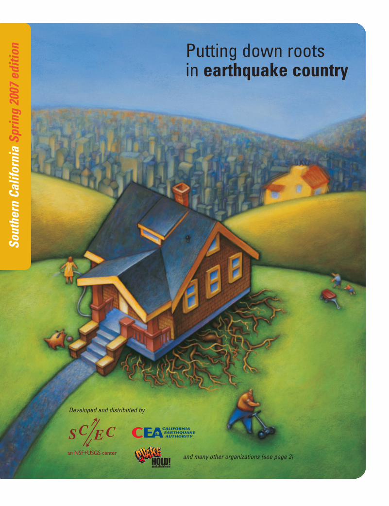
Southern California Spring 2007 edition Putting down roots in earthquake country Developed and distributed by and many other organizations (see page 2)
Transcript of Putting down roots in earthquake country - Official · PDF fileSpring 2007 edition Putting...
Sout
hern
Cal
iforn
ia S
prin
g 20
07 e
ditio
n Putting down roots in earthquake country
Developed and distributed by
and many other organizations (see page 2)
Why
sho
uld
I car
e?
2
Intr
oduc
tion
Copyright 2007, Southern California Earthquake Center(SCEC). Reproduction by permission only.
SCEC is a research consortium supported by the National
Science Foundation and the United States Geological Survey,
headquartered at the University of Southern California.
“Every day is earthquake season in California” is a service mark of the California Earthquake Authority and is used with permission.
Disclaimer: The suggestions and illustrations included in thisdocument are intended to improve earthquake awareness andpreparedness; however, they do not guarantee the safety of anindividual or a structure. The writers, contributors, and sponsorsof this handbook do not assume liability for any injury, death,property damage, or other effect of an earthquake.
Prepared by the Southern California Earthquake Center (SCEC)and the Department of the Interior United States GeologicalSurvey (USGS), in cooperation with the National ScienceFoundation (NSF), the Department of Homeland Security FederalEmergency Management Agency (FEMA), and the CaliforniaEarthquake Authority (CEA), with contributions from many mem-bers of the Earthquake Country Alliance
Writers: Lucile M. Jones, USGS and Mark Benthien, SCEC
Producers: Mark Benthien and Robert de Groot, SCEC (secondedition) and Jill Andrews, SCEC (first edition)
Contributors: SCEC (USC): Ilene Cooper, Thomas Henyey, JohnMarquis, Suzanne Perry, Glenn Song, Brion Vibber; USGS:
Kenneth Hudnut, Ken Rukstales, Michael Rymer, Bob Simpson,David Wald, Lisa Wald; FEMA: Hassaan Sughayer, DennisSylvester, Doug Bausch, Jeffrey Lusk; California Office of
Emergency Services: Greg Renick, Deborah Steffen, JamesGoltz; California Geological Survey: Jerry Treiman, Chris Wills,Charles Real; California Seismic Safety Commission: FredTurner; California Earthquake Authority: Nancy Kinkaid;Insurance Information Network of California: Candy Miller;American Red Cross: Peggy Brutsche, Rocky Lopes; County of
Los Angeles: Joyce Harris, Phyllis Tan, Larry Collins; Caltech:
Vikki Appel, Egill Hauksson, Margaret Vinci; Harvard: AndreasPlesch, John Shaw; KFWB: Jack Popejoy; Trevco: Dean Reese,Brian Lowe, Jeff Primes; and many other members of the
Earthquake Country Alliance
Special thanks to members of the 1906 Earthquake Centennial
Alliance for improvements implemented in the San FranciscoBay Region version of this handbook, many of which now havebeen adopted in this Southern California edition.
Design: Denton Design Associates: Margi S. Denton, Elizabeth Burrill
Illustrators: Fuel Creative Group (p. 13); Daniel Clark (p. 18);Todd Connor (p. 14–15); Dale Glasgow (p. 24); Min Jae Hong (p. 16, 19, 29); Stephanie Langley ( p. 4, 6, 10, 14, 19, 20, 26);Punchstock (p. 17, 21); Jere Smith (cover, p. 2, 3, 32); and RobertZimmerman (p. 14, 16, 18, 19).
Southern California is Earthquake Country
4 Southern California earthquakes6 Southern California faults8 Earthquake shaking potential in Southern California10 Other earthquake-related hazards in
Southern California
Wha
t sho
uld
I kno
w?
Wha
t sho
uld
I do?
3
Introduction
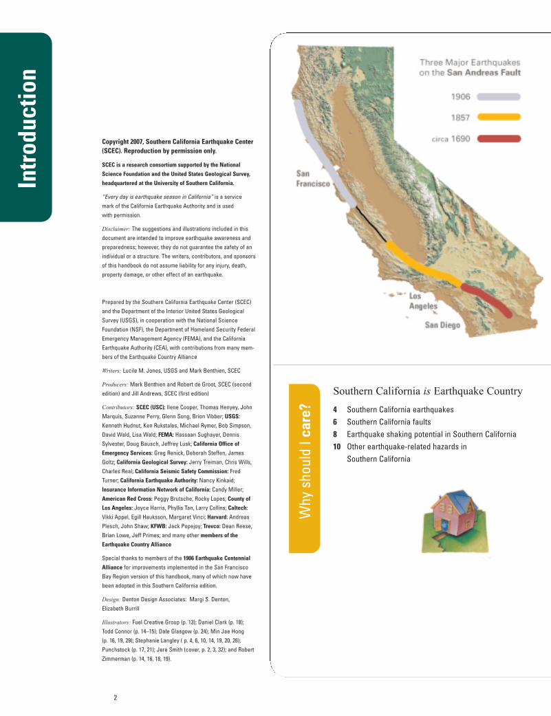
Generations of Californians have been "putting down roots" along one of the world's mostfamous faults—the San Andreas. However, few Californians have experienced a major SanAndreas earthquake. In Northern California, the last major earthquake was 100 years ago in1906. Over 3,000 people were killed and 225,000 people were left homeless. In SouthernCalifornia, the last major earthquake on the San Andreas fault was 150 years ago (1857), rupturing the fault from Central California to San Bernardino. Few people lived in the area, so there was very little damage.
Further south along the San Andreas fault, from San Bernardino through the Coachella Valley to the Salton Sea, over 300 years have passed since the last major earthquake (around1690). Another major earthquake is likely to happen on this section of the fault within our lifetime. When it does, all of Southern California will be shaken and many areas may beheavily damaged.
There are hundreds of other faults throughout Southern California that could also causedamaging earthquakes. Some may happen before the next major San Andreas earthquake.Southern California is earthquake country, and every day is earthquake season.
This handbook provides information about why we should care about earthquakes inSouthern California, what we should do to be safe and reduce damage, and also what weshould know about earthquake basics.
Earthquake Basics
24 Earthquakes 25 Faults 26 Locating and measuring earthquakes 28 Earthquake shaking 30 Information available after earthquakes
The Resource Mine
32 Web resources
The Seven Steps to Earthquake Safety
12 The seven steps to earthquake safety14 STEP #1: Identify potential hazards in your home and
begin to fix them. 16 STEP #2: Create a disaster-preparedness plan. 17 STEP #3: Prepare disaster supplies kits.18 STEP #4: Identify your building’s potential
weaknesses and begin to fix them. 19 STEP #5: Protect yourself during earthquake shaking—
drop, cover, and hold on. 20 STEP #6: After the earthquake, check for injuries
and damage. 21 STEP #7: When safe, continue to follow your
disaster-preparedness plan.22 Reducing the costs of
earthquakes in California
4
Why
sho
uld
I car
e?
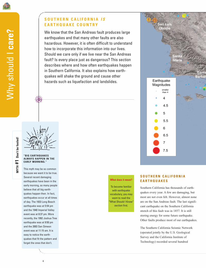
S O U T H E R N C A L I F O R N I AE A R T H Q U A K E S
Southern California has thousands of earth-
quakes every year. A few are damaging, but
most are not even felt. However, almost none
are on the San Andreas fault. The last signifi-
cant earthquake on the Southern California
stretch of this fault was in 1857. It is still
storing energy for some future earthquake.
Other faults produce most of our earthquakes.
The Southern California Seismic Network
(operated jointly by the U.S. Geological
Survey and the California Institute of
Technology) recorded several hundred
S O U T H E R N C A L I F O R N I A I SE A R T H Q U A K E C O U N T R Y
We know that the San Andreas fault produces largeearthquakes and that many other faults are also hazardous. However, it is often difficult to understandhow to incorporate this information into our lives.Should we care only if we live near the San Andreasfault? Is every place just as dangerous? This sectiondescribes where and how often earthquakes happenin Southern California. It also explains how earth-quakes will shake the ground and cause other hazards such as liquefaction and landslides.
What does it mean?
To become familiarwith earthquake
vocabulary, you maywant to read the
“What Should I Know”section first.
“BIG EARTHQUAKESALWAYS HAPPEN IN THEEARLY MORNING.”
This myth may be so commonbecause we want it to be true.Several recent damagingearthquakes have been in theearly morning, so many peoplebelieve that all big earth-quakes happen then. In fact,earthquakes occur at all timesof day. The 1933 Long Beachearthquake was at 5:54 pmand the 1940 Imperial Valleyevent was at 8:37 pm. Morerecently, the 1992 Joshua Treeearthquake was at 9:50 pmand the 2003 San Simeonevent was at 11:15 am. It iseasy to notice the earth-quakes that fit the pattern andforget the ones that don’t.
MYT
H#1
Don
’t be
fool
ed!
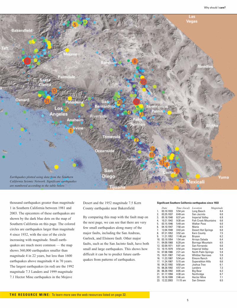
Earthquakes plotted using data from the SouthernCalifornia Seismic Network. Significant earthquakesare numbered according to the table below.
5
Why should I care?
Desert and the 1952 magnitude 7.5 Kern
County earthquake near Bakersfield.
By comparing this map with the fault map on
the next page, we can see that there are very
few small earthquakes along many of the
major faults, including the San Andreas,
Garlock, and Elsinore fault. Other major
faults, such as the San Jacinto fault, have both
small and large earthquakes. This shows how
difficult it can be to predict future earth-
quakes from patterns of earthquakes.
T H E R E S O U R C E M I N E : To learn more see the web resources listed on page 32.
Significant Southern California earthquakes since 1933
Date Time (local) Location Magnitude1. 03.10.1933 5:54 pm Long Beach 6.42. 03.25.1937 8:49 am San Jacinto 6.03. 05.18.1940 8:37 pm Imperial Valley 6.94. 10.21.1942 9:30 am Fish Creek Mountains 6.65. 03.15.1946 5:49 am Walker Pass 6.06. 04.10.1947 7:58 am Manix 6.57. 12.04.1948 3:43 pm Desert Hot Springs 6.08. 07.21.1952 3:52 am Kern County 7.59. 11.21.1952 11:46 pm Bryson 6.210. 03.19.1954 1:54 am Arroyo Salada 6.411. 04.09.1968 6:29 pm Borrego Mountain 6.512. 02.09.1971 6:01 am San Fernando 6.613. 10.15.1979 4:54 pm Imperial Valley 6.414. 07.08.1986 2:21 am North Palm Springs 5.915. 10.01.1987 7:42 am Whittier Narrows 5.916. 11.23.1987 5:54 pm Elmore Ranch 6.217. 11.24.1987 5:15 am Superstition Hills 6.618. 04.22.1992 9:50 pm Joshua Tree 6.119. 06.28.1992 4:57 am Landers 7.320. 06.28.1992 8:05 am Big Bear 6.321. 01.17.1994 4:30 am Northridge 6.722. 10.16.1999 2:46 am Hector Mine 7.123. 12.22.2003 11:15 am San Simeon 6.5
thousand earthquakes greater than magnitude
1 in Southern California between 1981 and
2003. The epicenters of these earthquakes are
shown by the dark blue dots on the map of
Southern California on this page. The colored
circles are earthquakes larger than magnitude
4 since 1932, with the size of the circle
increasing with magnitude. Small earth-
quakes are much more common — the map
shows 360,000 earthquakes smaller than
magnitude 4 in 22 years, but less than 1600
earthquakes above magnitude 4 in 70 years.
The largest earthquakes (in red) are the 1992
magnitude 7.3 Landers and 1999 magnitude
7.1 Hector Mine earthquakes in the Mojave
6
Why
sho
uld
I car
e?
SOUTHERN CALIFORNIA FAULTS
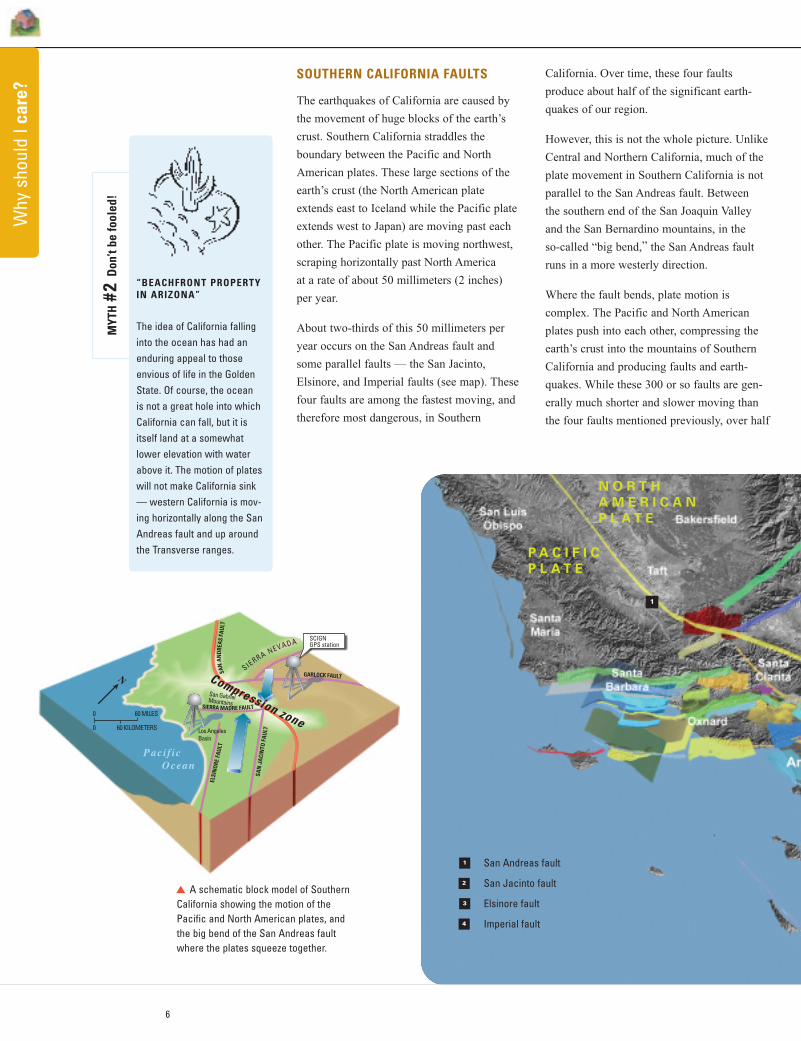
The earthquakes of California are caused by
the movement of huge blocks of the earth’s
crust. Southern California straddles the
boundary between the Pacific and North
American plates. These large sections of the
earth’s crust (the North American plate
extends east to Iceland while the Pacific plate
extends west to Japan) are moving past each
other. The Pacific plate is moving northwest,
scraping horizontally past North America
at a rate of about 50 millimeters (2 inches)
per year.
About two-thirds of this 50 millimeters per
year occurs on the San Andreas fault and
some parallel faults — the San Jacinto,
Elsinore, and Imperial faults (see map). These
four faults are among the fastest moving, and
therefore most dangerous, in Southern
SCIGNGPS station
Compression zone
SIERRA NEVADA
ELSI
NOR
E FA
ULT
SAN
JAC
INTO
FAU
LT
SIERRA MADRE FAULT
GARLOCK FAULT
Pacif ic Ocean
Los AngelesBasin
San GabrielMountains
N
SAN
ANDR
EAS
FAUL
T
60 MILES0
0 60 KILOMETERS
A schematic block model of SouthernCalifornia showing the motion of thePacific and North American plates, andthe big bend of the San Andreas faultwhere the plates squeeze together.
California. Over time, these four faults
produce about half of the significant earth-
quakes of our region.
However, this is not the whole picture. Unlike
Central and Northern California, much of the
plate movement in Southern California is not
parallel to the San Andreas fault. Between
the southern end of the San Joaquin Valley
and the San Bernardino mountains, in the
so-called “big bend,” the San Andreas fault
runs in a more westerly direction.
Where the fault bends, plate motion is
complex. The Pacific and North American
plates push into each other, compressing the
earth’s crust into the mountains of Southern
California and producing faults and earth-
quakes. While these 300 or so faults are gen-
erally much shorter and slower moving than
the four faults mentioned previously, over half
“BEACHFRONT PROPERTYIN ARIZONA”
The idea of California fallinginto the ocean has had anenduring appeal to those envious of life in the GoldenState. Of course, the ocean is not a great hole into whichCalifornia can fall, but it isitself land at a somewhatlower elevation with waterabove it. The motion of plateswill not make California sink— western California is mov-ing horizontally along the SanAndreas fault and up aroundthe Transverse ranges.
MYT
H#2
Don
’t be
fool
ed!
N O R T H
A M E R I C A N
P L A T E
P A C I F I C
P L A T E
1
1
2
3
4
San Andreas fault
San Jacinto fault
Elsinore fault
Imperial fault
k
7
Why should I care?
SCIGN station located in Elysian Park near downtown Los Angeles
Unknown faultsAs the Northridge earthquake confirmed, somefaults are not known until they move in largeand damaging earthquakes. What do we doabout these unknown faults we can’t see anddon’t know about yet? Do we still have to waituntil the next earthquake reveals them?
Not necessarily. In 2001, scientists of theSouthern California Earthquake Center completed the Southern California IntegratedGPS Network (SCIGN), an advanced system of250 Global Positioning System (GPS) receivers.With this network the positions of locationsthroughout Southern California can be precisely measured. This network is now a partof an even larger system, the Plate BoundaryObservatory, which is measuring movementthroughout the western United States.
By measuring these locations for several years,we can see how different sites are moving relative to each other—for instance, PalosVerdes is moving toward Pasadena at about 4 millimeters (5/32 inch) per year. If movementbetween two locations is greater than themovement on known faults, then we have areasonable idea that there may be another fault in the area, perhaps buried by sediment. This can lead to focused research using other methods to identify the unknown fault.
Geologic rates
The rate of plate movement along the San
Andreas fault, 33 millimeters (1.3 inches)
each year, is about how fast your fingernails
grow. As a result, Los Angeles City Hall is
now 2.7 meters (9 feet) closer to San
Francisco than when it was built in 1924.
It would take a mere (geologically speaking)
2 million years for your nails to extend 100
kilometers (60 miles) from San Bernardino to
Palmdale. It took many millions of years of
movement on faults (earthquakes) to shape
Southern California’s current landscape.
of the significant earthquakes in Southern
California occur on these faults.
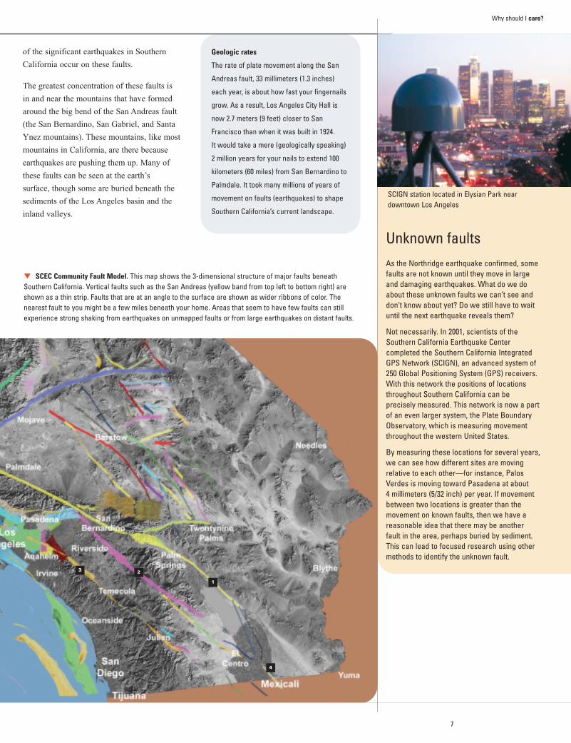
The greatest concentration of these faults is
in and near the mountains that have formed
around the big bend of the San Andreas fault
(the San Bernardino, San Gabriel, and Santa
Ynez mountains). These mountains, like most
mountains in California, are there because
earthquakes are pushing them up. Many of
these faults can be seen at the earth’s
surface, though some are buried beneath the
sediments of the Los Angeles basin and the
inland valleys.
SCEC Community Fault Model. This map shows the 3-dimensional structure of major faults beneathSouthern California. Vertical faults such as the San Andreas (yellow band from top left to bottom right) areshown as a thin strip. Faults that are at an angle to the surface are shown as wider ribbons of color. The nearest fault to you might be a few miles beneath your home. Areas that seem to have few faults can stillexperience strong shaking from earthquakes on unmapped faults or from large earthquakes on distant faults.
1
4
23
k
8
Why
sho
uld
I car
e?
EARTHQUAKE SHAKING POTENTIALIN SOUTHERN CALIFORNIA
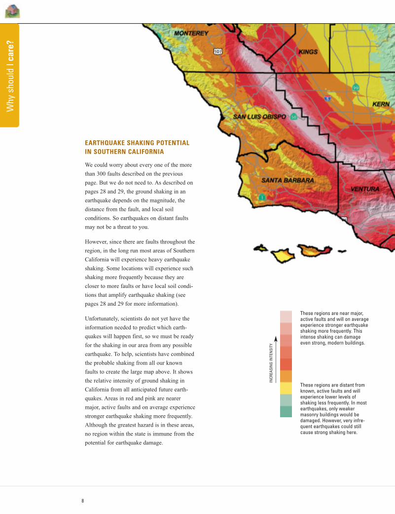
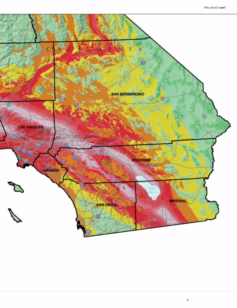
We could worry about every one of the more
than 300 faults described on the previous
page. But we do not need to. As described on
pages 28 and 29, the ground shaking in an
earthquake depends on the magnitude, the
distance from the fault, and local soil
conditions. So earthquakes on distant faults
may not be a threat to you.
However, since there are faults throughout the
region, in the long run most areas of Southern
California will experience heavy earthquake
shaking. Some locations will experience such
shaking more frequently because they are
closer to more faults or have local soil condi-
tions that amplify earthquake shaking (see
pages 28 and 29 for more information).
Unfortunately, scientists do not yet have the
information needed to predict which earth-
quakes will happen first, so we must be ready
for the shaking in our area from any possible
earthquake. To help, scientists have combined
the probable shaking from all our known
faults to create the large map above. It shows
the relative intensity of ground shaking in
California from all anticipated future earth-
quakes. Areas in red and pink are nearer
major, active faults and on average experience
stronger earthquake shaking more frequently.
Although the greatest hazard is in these areas,
no region within the state is immune from the
potential for earthquake damage.
INCR
EASI
NG
INTE
NSI
TY
These regions are near major,active faults and will on averageexperience stronger earthquakeshaking more frequently. Thisintense shaking can damageeven strong, modern buildings.
These regions are distant fromknown, active faults and willexperience lower levels of shaking less frequently. In mostearthquakes, only weakermasonry buildings would bedamaged. However, very infre-quent earthquakes could stillcause strong shaking here.
9
Why should I care?
C A L I F O R N I A
10
Why
sho
uld
I car
e?
OTHER EARTHQUAKE-RELATED HAZARDS IN SOUTHERN CALIFORNIA
The previous pages have described where
earthquakes have happened, the many faults
in Southern California capable of large earth-
quakes, and the expected shaking from future
earthquakes. In addition to these regional
aspects of the earthquake hazard, there are
location-specific hazards that can cause addi-
tional damage: surface rupture, liquefaction,
and landslides. The California Geological
Survey produces maps that identify
Earthquake Fault Zones and Seismic Hazard
Zones where these hazards may occur. State
laws require that every person starting to “put
down roots” by buying a home or real proper-
ty in California be told if the property is in
one of these zones.
Earthquake Fault Zones (EFZs) recognize the
hazard of surface rupture that might occur
during an earthquake where an active fault
meets the earth’s surface. Few structures can
withstand fault rupture directly under their
foundations. The law requires that within an
EFZ most structures must be set back a safe
distance from identified active faults. The
necessary setback is established through geo-
logic studies of the site. EFZs are narrow
strips along the known active surface faults
wherein these studies are required prior to
development. Being located in an EFZ does
not necessarily mean that a building is on a
fault. Most of the important known faults in
California have been evaluated and zoned,
and modifications and additions to these
zones continue as we learn more.
Seismic Hazard Zones (SHZs) identify areas
that may be prone to liquefaction or landslid-
ing triggered by earthquake shaking. Lique-
faction is a temporary loss of strength in the
ground that can occur when certain water
saturated soils are shaken during a strong
earthquake. When this occurs buildings can
settle, tilt, or shift. Landsliding can occur
during an earthquake where shaking reduces
the strength of the slope. These hazards can
usually be reduced or eliminated through
established engineering methods. The law
requires that property being developed within
these zones be evaluated to determine if a
hazard exists at the site. If so, necessary
design changes must be made before a permit
is granted for residential construction. Being
in an SHZ does not mean that all structures in
the zone are in danger. The hazard may not
exist on each property or may have been
mitigated. Mapping new SHZs in urban and
urbanizing areas is ongoing statewide.
Current zones, as established by the
California Geological Survey, are indexed at
www.consrv.ca.gov/cgs.
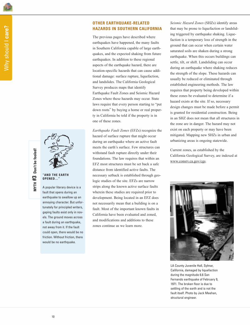
LA County Juvenile Hall, Sylmar,California, damaged by liquefactionduring the magnitude 6.6 SanFernando earthquake of February 9,1971. The broken floor is due to settling of the earth and is not the fault itself. Photo by Jack Meehan,structural engineer.
“AND THE EARTHOPENED…”
A popular literary device is afault that opens during anearthquake to swallow up anannoying character. But unfor-tunately for principled writers,gaping faults exist only in nov-els. The ground moves acrossa fault during an earthquake,not away from it. If the faultcould open, there would be nofriction. Without friction, therewould be no earthquake.
MYT
H#3
Don
’t be
fool
ed!
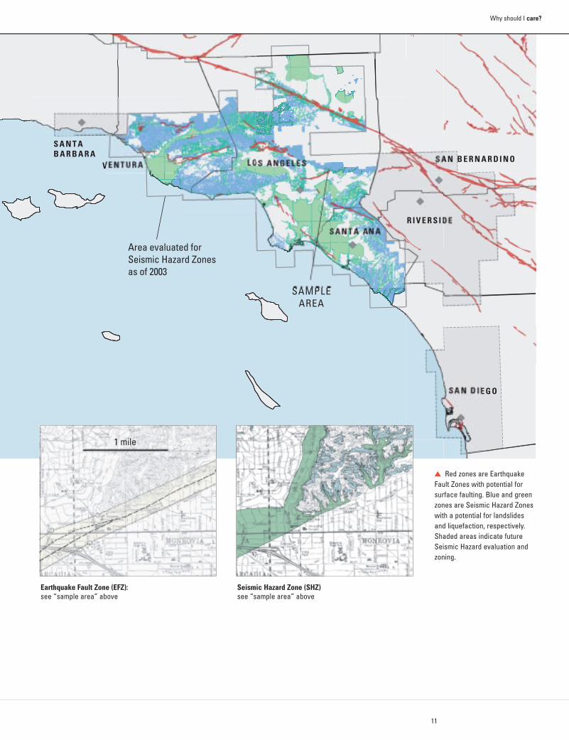
Area evaluated forSeismic Hazard Zonesas of 2003
SAMPLEAREA
S A N T AB A R B A R A
V E N T U R A L O S A N G E L E S S A N B E R N A R D I N O
R I V E R S I D ES A N T A A N A
S A N D I E G O
11
Why should I care?
Red zones are EarthquakeFault Zones with potential forsurface faulting. Blue and greenzones are Seismic Hazard Zoneswith a potential for landslidesand liquefaction, respectively.Shaded areas indicate futureSeismic Hazard evaluation andzoning.
1 mile
Earthquake Fault Zone (EFZ): see “sample area” above
Seismic Hazard Zone (SHZ)see “sample area” above
k
Wha
t sho
uld
I do?
T H E S E V E N S T E P S
T O E A R T H Q U A K E S A F E T Y
Earthquakes are inevitable, but the damage from earth-quakes is not. Many people think the destruction causedby earthquakes is unavoidable, and that our only option is to pick up the pieces after the shaking stops. No!Earthquake damage and loss can be limited by steps youtake before, during, and after. Many also think that all thedamage and injuries from earthquakes comes from collapsing buildings. Again, no! As buildings are designedbetter, more of the losses in earthquakes are from objectsthat break or fall on people causing injury.
The seven steps described in this section show how wecan be safer by knowing what to do before, during, andafter earthquakes. The steps may also save a lot of moneywhen structures and contents are not damaged. In additionto following the steps at home, they should also be fol-lowed in schools, workplaces, and other facilities. If we allfollow these steps, we may save billions of dollars in thenext large earthquake. Most importantly, we can reducethe risk of being injured or killed.
12
Follow these seven steps to prepare your home, your school, and your workplace for our next earthquake.
start here…
These steps were developed by members of
the Earthquake Country Alliance, which
includes leading earthquake professionals,
emergency managers, government officials,
business and community leaders, and others.
The recommendations are based on many
existing resources and the advice of many
organizations.
The members of the Earthquake Country
Alliance all have specific roles before, dur-
ing, and after earthquakes, to reduce earth-
quake damage and injuries, and to speed
recovery. Do your part. Dare to prepare by
following the seven steps described in this
section.
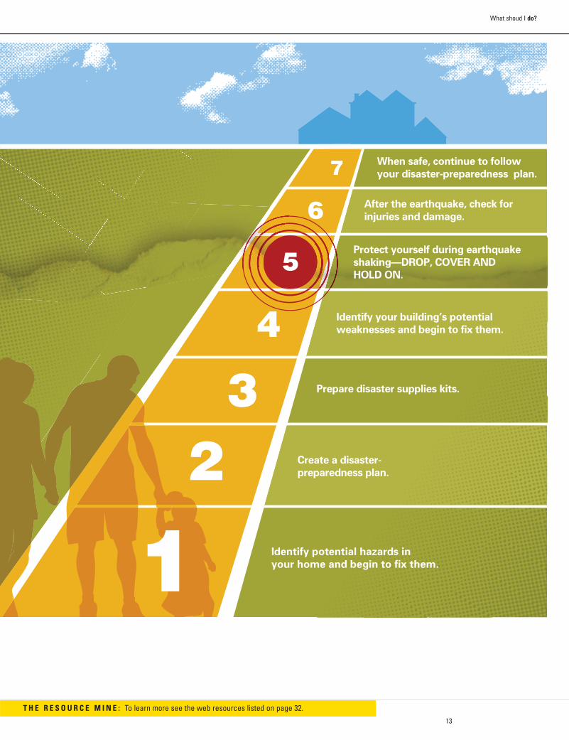
Identify potential hazards in
your home and begin to fix them.
Create a disaster-
preparedness plan.
Prepare disaster supplies kits.
When safe, continue to follow
your disaster-preparedness plan.
After the earthquake, check for
injuries and damage.
Protect yourself during earthquake
shaking—DROP, COVER AND
HOLD ON.
Identify your building’s potential
weaknesses and begin to fix them.
13
What shoud I do?
T H E R E S O U R C E M I N E : To learn more see the web resources listed on page 32.
14
Wha
t sho
uld
I do?
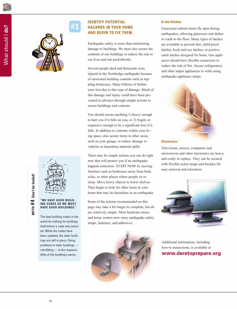
IDENTIFY POTENTIAL HAZARDS IN YOUR HOME AND BEGIN TO FIX THEM.
Earthquake safety is more than minimizing
damage to buildings. We must also secure the
contents of our buildings to reduce the risk to
our lives and our pocketbooks.
Several people died and thousands were
injured in the Northridge earthquake because
of unsecured building contents such as top-
pling bookcases. Many billions of dollars
were lost due to this type of damage. Much of
this damage and injury could have been pre-
vented in advance through simple actions to
secure buildings and contents.
You should secure anything 1) heavy enough
to hurt you if it falls on you, or 2) fragile or
expensive enough to be a significant loss if it
falls. In addition to contents within your liv-
ing space, also secure items in other areas,
such as your garage, to reduce damage to
vehicles or hazardous material spills.
There may be simple actions you can do right
now that will protect you if an earthquake
happens tomorrow. START NOW by moving
furniture such as bookcases away from beds,
sofas, or other places where people sit or
sleep. Move heavy objects to lower shelves.
Then begin to look for other items in your
home that may be hazardous in an earthquake.
Some of the actions recommended on this
page may take a bit longer to complete, but all
are relatively simple. Most hardware stores
and home centers now carry earthquake safety
straps, fasteners, and adhesives.
In the kitchen
Unsecured cabinet doors fly open during
earthquakes, allowing glassware and dishes
to crash to the floor. Many types of latches
are available to prevent this: child-proof
latches, hook and eye latches, or positive
catch latches designed for boats. Gas appli-
ances should have flexible connectors to
reduce the risk of fire. Secure refrigerators
and other major appliances to walls using
earthquake appliance straps.
Electronics
Televisions, stereos, computers and
microwaves and other electronics are heavy
and costly to replace. They can be secured
with flexible nylon straps and buckles for
easy removal and relocation.
#1
“WE HAVE GOOD BUILD-ING CODES SO WE MUSTHAVE GOOD BUILDINGS.”
The best building codes in theworld do nothing for buildingsbuilt before a code was enact-ed. While the codes havebeen updated, the older build-ings are still in place. Fixingproblems in older buildings —retrofitting — is the responsi-bility of the building’s owner.
MYT
H#4
Don
’t be
fool
ed!
Additional information, including
how-to instructions, is available at
www.daretoprepare.org
15
What shoud I do?
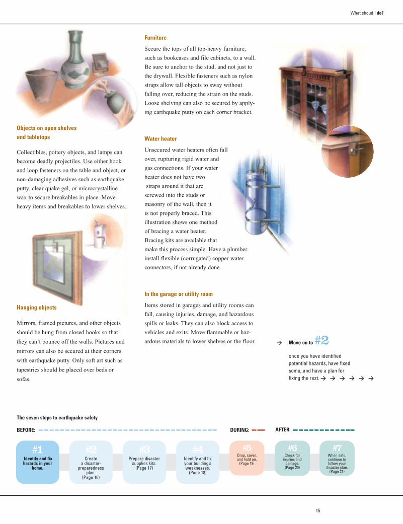
Furniture
Secure the tops of all top-heavy furniture,
such as bookcases and file cabinets, to a wall.
Be sure to anchor to the stud, and not just to
the drywall. Flexible fasteners such as nylon
straps allow tall objects to sway without
falling over, reducing the strain on the studs.
Loose shelving can also be secured by apply-
ing earthquake putty on each corner bracket.
Water heater
Unsecured water heaters often fall
over, rupturing rigid water and
gas connections. If your water
heater does not have two
straps around it that are
screwed into the studs or
masonry of the wall, then it
is not properly braced. This
illustration shows one method
of bracing a water heater.
Bracing kits are available that
make this process simple. Have a plumber
install flexible (corrugated) copper water
connectors, if not already done.
In the garage or utility room
Items stored in garages and utility rooms can
fall, causing injuries, damage, and hazardous
spills or leaks. They can also block access to
vehicles and exits. Move flammable or haz-
ardous materials to lower shelves or the floor.
Objects on open shelves and tabletops
Collectibles, pottery objects, and lamps can
become deadly projectiles. Use either hook
and loop fasteners on the table and object, or
non-damaging adhesives such as earthquake
putty, clear quake gel, or microcrystalline
wax to secure breakables in place. Move
heavy items and breakables to lower shelves.
Hanging objects
Mirrors, framed pictures, and other objects
should be hung from closed hooks so that
they can’t bounce off the walls. Pictures and
mirrors can also be secured at their corners
with earthquake putty. Only soft art such as
tapestries should be placed over beds or
sofas.
The seven steps to earthquake safety
#1Identify and fix hazards in your
home.
#2Create
a disaster-preparedness
plan. (Page 16)
#3Prepare disaster
supplies kits.(Page 17)
#4Identify and fix your building’s weaknesses.
(Page 18)
#5Drop, cover, and hold on.
(Page 19)
#6Check for
injuries and damage.(Page 20)
#7When safe, continue to follow your
disaster plan. (Page 21)
DURING:BEFORE: AFTER:
> Move on to#2once you have identified potential hazards, have fixed some, and have a plan for fixing the rest. > > > > > >
16
Wha
t sho
uld
I do?
CREATE A DISASTER-PREPAREDNESS PLAN.
Will everyone in your household do the right
thing during the violent shaking of a major
earthquake? Before the next earthquake, get
together with your family or housemates to
plan now what each person will do before,
during and after.
Once the earthquake is over, we will have to
live with the risk of fire, the potential lack of
utilities and basic services, and the certainty
of aftershocks. By planning now, you will be
ready. This plan will also be useful for other
emergencies.
Plan NOW to be safe during an earthquake:
�� Practice “drop, cover, and hold on.” (See Step 5, page 19)
�� Identify safe spots in every room, such as under sturdy desks and tables.
�� Learn how to protect yourself no matter whereyou are when an earthquake strikes.
Plan NOW to respond after an earthquake:
�� Keep shoes and a working flashlight next to each bed.
�� Teach everyone in your household to use emergency whistles and/or to knock three timesrepeatedly if trapped. Rescuers searching collapsed buildings will be listening for sounds.
�� Identify the needs of household members andneighbors with special requirements or situa-tions, such as use of a wheelchair, walking aids,special diets, or medication.
�� Take a Red Cross first aid and cardiopulmonaryresuscitation (CPR) training course. Learn whoelse in your neighborhood is trained in first aidand CPR.
�� Know the location of utility shutoffs and keepneeded tools nearby. Make sure you know howto turn off the gas, water, and electricity to yourhome. Only turn off the gas if you smell or hearleaking gas.
�� Get training from your local fire department inhow to properly use a fire extinguisher.
�� Install smoke alarms and test them monthly.Change the battery once a year, or when thealarm emits a "chirping" sound (low-battery signal).
�� Check with your city or county to see if there is aCommunity Emergency Response Team (CERT) inyour area. If not, ask how to start one.
The seven steps to earthquake safety
#1Identify and fix hazards
in your home.(Page 14)
#2Create
a disaster-preparedness
plan.
#3Prepare disaster
supplies kits.
#4Identify and fixyour building’s weaknesses.
(Page 18)
BEFORE:
#2
Plan NOW to communicate and recover after an earthquake:
�� Select a safe place outside of your home to meetyour family or housemates after the shakingstops.
�� Designate an out-of-area contact person whocan be called by everyone in the household torelay information.
�� Provide all family members with a list of impor-tant contact phone numbers.
�� Determine where you might live if your homecannot be occupied after an earthquake or otherdisaster.
�� Know about the earthquake plan developed byyour children's school or day care. Keep yourchildren's school emergency release card cur-rent.
�� Keep copies of essential documents, such asidentification, insurance policies, and financialrecords, in a secure, waterproof container, andkeep with your disaster supplies kits. Include ahousehold inventory (a list and photos or video ofyour belongings).
Have occasional earthquake “drills” to
practice your plan. Share your plan with
people who take care of your children, pets,
or home.
#5Drop, cover, and hold on.
(Page 19)
#6Check for
injuries and damage.
(Page 20)
#7When safe, continue to follow your
disaster plan. (Page 21)
DURING: AFTER:
> Move on to #3 once you have your plan, create your disastersupplies kits that you’ll use when you follow yourplan after an earthquake. > > > > >
17
What shoud I do?
PREPARE DISASTER SUPPLIES KITS.
Personal disaster supplies kits
Everyone should have personal disaster supplies kits. Keep them where you spend most of your
time, so they can be reached even if your building is badly damaged. The kits will be useful for
many emergencies.
Keep one kit in your home, another in your car, and a third kit at work. Backpacks or other
small bags are best for your disaster supplies kits so you can take them with you if you evacuate.
Include at least the following items:
Household disaster supplies kit
Electrical, water, transportation, and other vital systems can be disrupted for several days after a
large earthquake. Emergency response agencies and hospitals could be overwhelmed and unable
to provide you with immediate assistance. Providing first aid and having supplies will save lives,
will make life more comfortable, and will help you cope after the next earthquake.
In addition to your personal disaster supplies kits, store a household disaster supplies kit in an
easily accessible location (in a large watertight container that be easily moved), with a three-day
to one-week supply of the following items:
Use and replace perishable items like water, food, medications and batteries on a yearly basis.
�� Medications, prescription list, copies of medicalcards, doctor's name and contact information
�� Medical consent forms for dependents�� First aid kit and handbook�� Examination gloves (non-latex)�� Dust mask�� Spare eyeglasses or contact lenses and
cleaning solution�� Bottled water�� Whistle (to alert rescuers to your location)�� Sturdy shoes�� Emergency cash�� Road maps
�� List of emergency out-of-area contact phone numbers
�� Snack foods, high in water and calories�� Working flashlight with extra batteries and
light bulbs, or light sticks�� Personal hygiene supplies�� Comfort items such as games, crayons, writing
materials, teddy bears�� Toiletries and special provisions you need for
yourself and others in your family including elderly, disabled, small children, and animals.
�� Copies of personal identification (drivers license,work ID card, etc.)
�� Wrenches to turn off gas and water supplies�� Work gloves and protective goggles�� Heavy duty plastic bags for waste, and to serve
as tarps, rain ponchos, and other uses�� Portable radio with extra batteries�� Additional flashlights or light sticks�� Drinking water (minimum one gallon per person,
per day)�� Canned and packaged foods
�� Charcoal or gas grill for outdoor cooking andmatches if needed
�� Cooking utensils, including a manual can opener�� Pet food and pet restraints�� Comfortable, warm clothing including extra socks�� Blankets or sleeping bags, and perhaps even a
tent�� Copies of vital documents such as insurance
policies
#3
A special note about childrenIf earthquakes scare us because we feel out of
control, think how much more true this must be for
children, who already must depend on adults for
so much of their lives. It is important to spend time
with children in your care before the next earth-
quake to explain why earthquakes occur. Involve
them in developing your disaster plan, prepare
disaster supplies kits, and practice “drop, cover,
and hold on.” Consider simulating post-earth-
quake conditions by going without electricity or
tap water.
After the earthquake, remember that children will
be under great stress. They may be frightened,
their routine will probably be disrupted, and the
aftershocks won’t let them forget the experience.
Adults tend to leave their children in order to deal
with the many demands of the emergency, but this
can be devastating to children. Extra contact and
support from parents in the early days will pay off
later. Whenever possible, include them in the
recovery process.
> Move on to #4 to consider how to reduce damage to your homeand serious injury from building collapse. > >
18
Wha
t sho
uld
I do?
Common building problems
Most houses are not as safe as they could be.
The following presents some common struc-
tural problems and how to recognize them.
Once you determine if your building has one
or more of these problems, prioritize how
and when to fix them, and get started.
Inadequate foundations. Look under your
house at your foundation. If the foundation is
damaged or built in the “pier and post” style,
consult a contractor or engineer about replac-
ing it with a continuous perimeter foundation.
Look for bolts in the mudsills. They should be
no more than 1.8 meters (6 feet) apart in a
single story and 1.2 meters (4 feet) apart in a
multistory building. Adding bolts to unse-
cured houses is one of the most important
steps toward earthquake safety. This can be
done by a contractor or by someone skilled at
home maintenance.
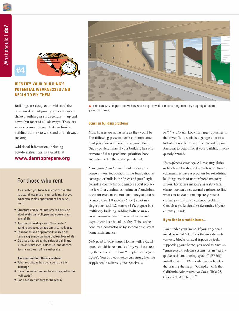
Unbraced cripple walls. Homes with a crawl
space should have panels of plywood connect-
ing the studs of the short “cripple” walls (see
figure). You or a contractor can strengthen the
cripple walls relatively inexpensively.
This cutaway diagram shows how weak cripple walls can be strengthened by properly attached plywood sheets.
#4
Soft first stories. Look for larger openings in
the lower floor, such as a garage door or a
hillside house built on stilts. Consult a pro-
fessional to determine if your building is ade-
quately braced.
Unreinforced masonry. All masonry (brick
or block walls) should be reinforced. Some
communities have a program for retrofitting
buildings made of unreinforced masonry.
If your house has masonry as a structural
element consult a structural engineer to find
what can be done. Inadequately braced
chimneys are a more common problem.
Consult a professional to determine if your
chimney is safe.
If you live in a mobile home...
Look under your home. If you only see a
metal or wood “skirt” on the outside with
concrete blocks or steel tripods or jacks
supporting your home, you need to have an
“engineered tie-down system” or an “earth-
quake-resistant bracing system” (ERBS)
installed. An ERBS should have a label on
the bracing that says, “Complies with the
California Administrative Code, Title 25,
Chapter 2, Article 7.5.”
IDENTIFY YOUR BUILDING’S POTENTIAL WEAKNESSES ANDBEGIN TO FIX THEM.
Buildings are designed to withstand the
downward pull of gravity, yet earthquakes
shake a building in all directions — up and
down, but most of all, sideways. There are
several common issues that can limit a
building’s ability to withstand this sideways
shaking.
Additional information, including
how-to instructions, is available at
www.daretoprepare.org
For those who rentAs a renter, you have less control over thestructural integrity of your building, but youdo control which apartment or house yourent:
• Structures made of unreinforced brick orblock walls can collapse and cause greatloss of life.
• Apartment buildings with "tuck-under" parking space openings can also collapse.
• Foundation and cripple wall failures cancause expensive damage but less loss of life.
• Objects attached to the sides of buildings,such as staircases, balconies, and decora-tions, can break off in earthquakes.
Ask your landlord these questions:• What retrofitting has been done on this
building?• Have the water heaters been strapped to the
wall studs?• Can I secure furniture to the walls?
k
19
What shoud I do?
PROTECT YOURSELF DURING EARTHQUAKE SHAKING—DROP, COVER, AND HOLD ON.
The previous pages have concentrated on
getting ready for the next earthquake. What
should you do during and after earthquakes?
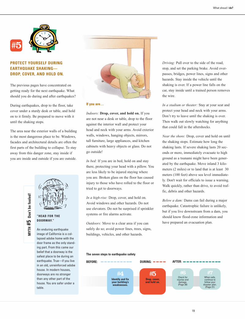
During earthquakes, drop to the floor, take
cover under a sturdy desk or table, and hold
on to it firmly. Be prepared to move with it
until the shaking stops.
The area near the exterior walls of a building
is the most dangerous place to be. Windows,
facades and architectural details are often the
first parts of the building to collapse. To stay
away from this danger zone, stay inside if
you are inside and outside if you are outside.
Driving: Pull over to the side of the road,
stop, and set the parking brake. Avoid over-
passes, bridges, power lines, signs and other
hazards. Stay inside the vehicle until the
shaking is over. If a power line falls on the
car, stay inside until a trained person removes
the wire.
In a stadium or theater: Stay at your seat and
protect your head and neck with your arms.
Don’t try to leave until the shaking is over.
Then walk out slowly watching for anything
that could fall in the aftershocks.
Near the shore: Drop, cover and hold on until
the shaking stops. Estimate how long the
shaking lasts. If severe shaking lasts 20 sec-
onds or more, immediately evacuate to high
ground as a tsunami might have been gener-
ated by the earthquake. Move inland 3 kilo-
meters (2 miles) or to land that is at least 30
meters (100 feet) above sea level immediate-
ly. Don't wait for officials to issue a warning.
Walk quickly, rather than drive, to avoid traf-
fic, debris and other hazards.
Below a dam: Dams can fail during a major
earthquake. Catastrophic failure is unlikely,
but if you live downstream from a dam, you
should know flood-zone information and
have prepared an evacuation plan.
The seven steps to earthquake safety
#4Identify and fixyour building’s weaknesses.
#5Drop, cover,and hold on.
DURING:BEFORE:
#5
“HEAD FOR THE DOORWAY.”
An enduring earthquakeimage of California is a col-lapsed adobe home with thedoor frame as the only stand-ing part. From this came ourbelief that a doorway is thesafest place to be during anearthquake. True—if you livein an old, unreinforced adobehouse. In modern houses,doorways are no strongerthan any other part of thehouse. You are safer under atable.
MYT
H#5
Don
’t be
fool
ed!
#6Check for
injuries and damage.(Page 20)
#7When safe, continue to follow your
disaster plan. (Page 21)
AFTER:
If you are…
Indoors: Drop, cover, and hold on. If you
are not near a desk or table, drop to the floor
against the interior wall and protect your
head and neck with your arms. Avoid exterior
walls, windows, hanging objects, mirrors,
tall furniture, large appliances, and kitchen
cabinets with heavy objects or glass. Do not
go outside!
In bed: If you are in bed, hold on and stay
there, protecting your head with a pillow. You
are less likely to be injured staying where
you are. Broken glass on the floor has caused
injury to those who have rolled to the floor or
tried to get to doorways.
In a high-rise: Drop, cover, and hold on.
Avoid windows and other hazards. Do not
use elevators. Do not be surprised if sprinkler
systems or fire alarms activate.
Outdoors: Move to a clear area if you can
safely do so; avoid power lines, trees, signs,
buildings, vehicles, and other hazards.
20
Wha
t sho
uld
I do?
AFTER THE EARTHQUAKE, CHECK FOR INJURIES AND DAMAGE
First take care of your own situation.
Remember your emergency plans.
Aftershocks may cause additional damage or
items to fall, so get to a safe location. Take
your disaster supplies kit.
If you are trapped by falling items or a
collapse, protect your mouth, nose, and eyes
from dust. If you are bleeding, put pressure on
the wound and elevate the injured part. Signal
for help with your emergency whistle, a cell
phone, or knock loudly on solid pieces of the
building, three times every few minutes.
Rescue personnel will be listening for such
sounds.
Once you are safe, help others and check for
damage. Protect yourself by wearing sturdy
shoes and work gloves, to avoid injury from
broken glass and debris. Also wear a dust
mask and eye protection.
Check for injuries
• Check your first aid kit or the front pages
of your telephone book for detailed
instructions on first aid measures.
• If a person is bleeding, put direct pressure
on the wound. Use clean gauze or cloth, if
available.
• If a person is not breathing, administer
rescue breathing.
• If a person has no pulse, begin CPR
(cardiopulmonary resuscitation).
• Do not move seriously injured persons
unless they are in immediate danger of
further injury.
• Cover injured persons with blankets or
additional clothing to keep them warm.
• Get medical help for serious injuries.
• Carefully check children or others needing
special assistance.
Check for damage
• FIRE. If possible, put out small fires in
your home or neighborhood immediately.
Call for help, but don’t wait for the fire
department.
• GAS LEAKS. Shut off the main gas valve
only if you suspect a leak because of
broken pipes or the odor or sound of
leaking natural gas. Don’t turn it back on
yourself — wait for the gas company to
check for leaks. The phone book has
detailed information on this topic.
• DAMAGED ELECTRICAL WIRING. Shut off
power at the main breaker switch if there is
any damage to your house wiring. Leave
the power off until the damage is repaired.
• BROKEN LIGHTS AND APPLIANCES.Unplug these as they could start fires when
electricity is restored.
• DOWNED POWER LINES. If you see downed
power lines, consider them energized and
stay well away from them. Keep others away
from them. Never touch downed power
lines or any objects in contact with them.
• FALLEN ITEMS. Beware of items tumbling
off shelves when you open closet and
cupboard doors.
• SPILLS. Use extreme caution. Clean up any
spilled medicines, drugs, or other non-toxic
substances. Potentially harmful materials
such as bleach, lye, garden chemicals, and
gasoline or other petroleum products should
be isolated or covered with an absorbent
such as dirt or cat litter. When in doubt,
leave your home.
• DAMAGED MASONRY. Stay away from
chimneys and walls made of brick or block.
They may be weakened and could topple
during aftershocks. Don’t use a fireplace
with a damaged chimney. It could start a
fire or let poisonous gases into your home.
“EVERYONE WILL PANICDURING THE BIG ONE!”
A common belief is that peo-ple always panic and runaround madly during and afterearthquakes, creating moredanger for themselves andothers. Actually, researchshows that people usuallytake protective actions andhelp others both during andafter the shaking. Most peopledon’t get too shaken up aboutbeing shaken up!
MYT
H#6
Don
’t be
fool
ed!
#6
The seven stepsto earthquake safety
#6Check for injuries
and damage.
#7When safe, continue to follow your
disaster plan.
AFTER:
Once you have recovered from the earthquake, go back to Step 1 and do the things you did not do before, or do them more thoroughly. Learn from what happened during the earthquake so you will be safer next time.
21
What shoud I do?
WHEN SAFE, CONTINUE TO FOLLOW YOUR DISASTER-PREPAREDNESSPLAN.
Once you have met your and your family's
immediate needs after an earthquake, contin-
ue to follow the plan you prepared in advance
(see Step 2, page 16). Aftershocks will continue
to happen for several weeks after major
earthquakes. Some may be large enough to
cause additional damage. Always be ready to
drop, cover, and hold on.
Your recovery period can take several weeks
to months or longer. Take the actions listed
below to be safe and to minimize the long-
term effects of the earthquake on your life.
The first days after the earthquake…
Use the information you put together in your
disaster plan and the supplies you organized
in your disaster kits. Until you are sure there
are no gas leaks, do not use open flames
(lighters, matches, candles, or grills) or oper-
ate any electrical or mechanical device that
can create a spark (light switches, generators,
motor vehicles, etc.). Never use the following
indoors: camp stoves, gas lanterns or heaters,
gas or charcoal grills, or gas generators.
These can release deadly carbon monoxide or
be a fire hazard in aftershocks.
Be in communication
• Turn on your portable or car radio for
information and safety advisories.
• Place all phones back on their cradles.
• Call your out-of-area contact, tell them
your status, then stay off the phone.
Emergency responders need to use the
phone lines for life-saving communica-
tions.
• Check on the condition of your neighbors.
Food and water
• If power is off, plan meals to use up refrig-
erated and frozen foods first. If you keep
the door closed, food in your freezer may
be good for a couple of days.
• Listen to your radio for safety advisories.
• If your water is off or unsafe, you can
drink from water heaters, melted ice cubes,
or canned vegetables. Avoid drinking water
from swimming pools or spas.
• Do not eat or drink anything from open
containers that are near shattered glass.
The first weeks after the earthquake…
This is a time of transition. Although after-
shocks may continue, you will now work
toward getting your life, your home and
family, and your routines back in order.
Emotional care and recovery are just as
important as healing physical injuries and
rebuilding a home. Make sure your home is
safe to occupy and not in danger of collapse
in aftershocks. If you were able to remain in
your home or return to it after a few days,
you will have a variety of tasks to accom-
plish:
• If your gas was turned off, you will need to
arrange for the gas company to turn it back
on.
• If the electricity went off and then came
back on, check your appliances and elec-
tronic equipment for damage.
• If water lines broke, look for water damage.
• Locate and/or replace critical documents
that may have been misplaced, damaged,
or destroyed.
• Contact your insurance agent or company
right away to begin your claims process.
• Contact the Federal Emergency
Management Agency (FEMA) to find out
about financial assistance
(www.fema.gov/about/process/).
#7
If you cannot stay inyour home…If your home is structurally unsafe or threat-ened by a fire or other hazard, you need toevacuate. However, shelters may be over-crowded and initially lack basic services, sodo not leave home just because utilities areout of service or your home and its contentshave suffered moderate damage.
If you evacuate, tell a neighbor and your out-of-area contact where you are going. As soonas possible, set up an alternative mailingaddress with the post office. Take the follow-ing, if possible, when you evacuate:
�� Personal disaster supplies kits �� Medications and eyewear �� Supply of water, food, and snacks �� Blanket/pillow/air mattress or sleeping pad �� Change of clothing and a jacket �� Towel and washcloth �� Diapers, food, and other supplies for infants �� A few family pictures or other comfort items �� Personal identification and copies of
household and health insurance information.
Do not take to a shelter:• Pets (Service animals for people with
disabilities are allowed; take food for them.Have a plan for your pets in advance.)
• Large quantities of unnecessary clothing or other personal items
• Valuables that might be lost, stolen, or takeup needed space
Once a Presidential Declaration has beenissued, FEMA may activate the Individualsand Households Program. This programincludes:• Home-repair cash grants; the maximum
Federal grant available (as of 2005) is$26,200
• Housing Assistance in the form of reim-bursement for short-term lodging at a hotel
• Rental assistance for as long as 18 monthsin the form of cash payment
• If no other housing is available, FEMA mayprovide mobile homes or other temporaryhousing
Wha
t sho
uld
I do?
22
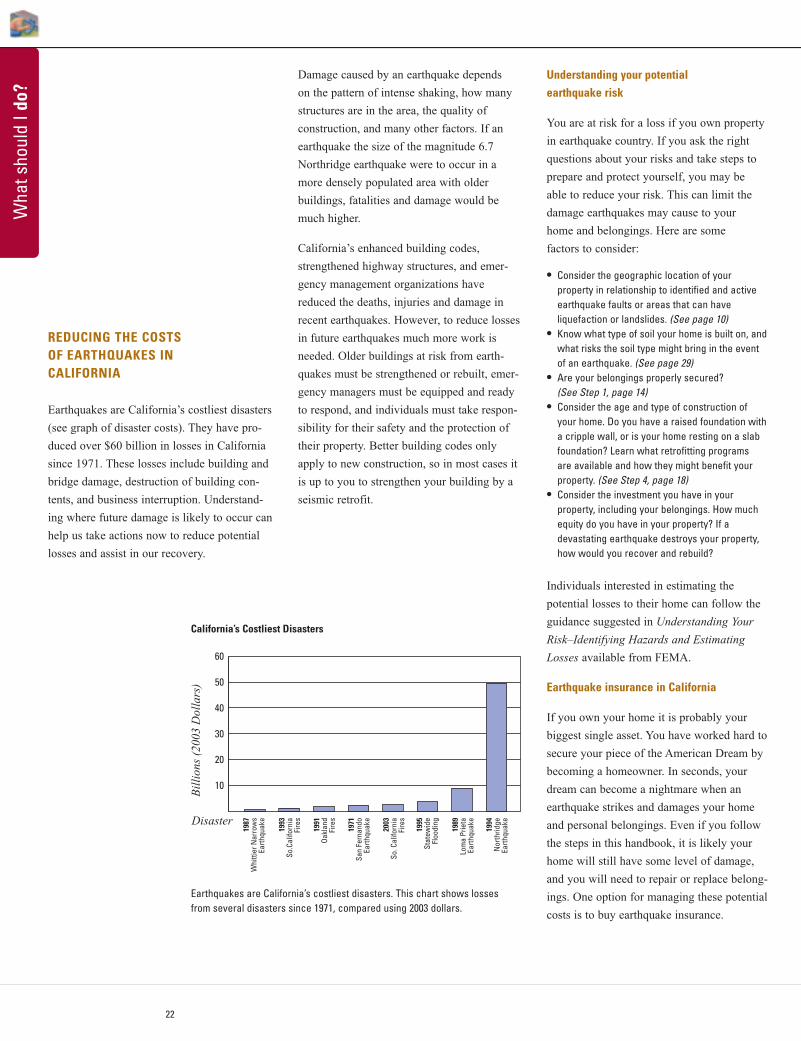
REDUCING THE COSTS OF EARTHQUAKES IN CALIFORNIA
Earthquakes are California’s costliest disasters
(see graph of disaster costs). They have pro-
duced over $60 billion in losses in California
since 1971. These losses include building and
bridge damage, destruction of building con-
tents, and business interruption. Understand-
ing where future damage is likely to occur can
help us take actions now to reduce potential
losses and assist in our recovery.
Understanding your potentialearthquake risk
You are at risk for a loss if you own property
in earthquake country. If you ask the right
questions about your risks and take steps to
prepare and protect yourself, you may be
able to reduce your risk. This can limit the
damage earthquakes may cause to your
home and belongings. Here are some
factors to consider:
• Consider the geographic location of your property in relationship to identified and activeearthquake faults or areas that can have liquefaction or landslides. (See page 10)
• Know what type of soil your home is built on, andwhat risks the soil type might bring in the eventof an earthquake. (See page 29)
• Are your belongings properly secured? (See Step 1, page 14)
• Consider the age and type of construction ofyour home. Do you have a raised foundation witha cripple wall, or is your home resting on a slabfoundation? Learn what retrofitting programs are available and how they might benefit yourproperty. (See Step 4, page 18)
• Consider the investment you have in your property, including your belongings. How muchequity do you have in your property? If a devastating earthquake destroys your property,how would you recover and rebuild?
Individuals interested in estimating the
potential losses to their home can follow the
guidance suggested in Understanding Your
Risk–Identifying Hazards and Estimating
Losses available from FEMA.
Earthquake insurance in California
If you own your home it is probably your
biggest single asset. You have worked hard to
secure your piece of the American Dream by
becoming a homeowner. In seconds, your
dream can become a nightmare when an
earthquake strikes and damages your home
and personal belongings. Even if you follow
the steps in this handbook, it is likely your
home will still have some level of damage,
and you will need to repair or replace belong-
ings. One option for managing these potential
costs is to buy earthquake insurance.
10
20
30
40
50
60
Disaster
Bill
ions
(20
03 D
olla
rs)
1987
Whi
ttier
Nar
row
sEa
rthqu
ake
1993
So.
Calif
orni
aFi
res
1991
Oak
land
Fire
s
1971
San
Fer
nand
oEa
rthqu
ake
2003
So.
Cal
iforn
iaFi
res
1995
Stat
ewid
eFl
oodi
ng
1989
Lom
a Pr
ieta
Earth
quak
e
1994
Nor
thrid
geEa
rthqu
ake
Earthquakes are California’s costliest disasters. This chart shows lossesfrom several disasters since 1971, compared using 2003 dollars.
California’s Costliest Disasters
Damage caused by an earthquake depends
on the pattern of intense shaking, how many
structures are in the area, the quality of
construction, and many other factors. If an
earthquake the size of the magnitude 6.7
Northridge earthquake were to occur in a
more densely populated area with older
buildings, fatalities and damage would be
much higher.
California’s enhanced building codes,
strengthened highway structures, and emer-
gency management organizations have
reduced the deaths, injuries and damage in
recent earthquakes. However, to reduce losses
in future earthquakes much more work is
needed. Older buildings at risk from earth-
quakes must be strengthened or rebuilt, emer-
gency managers must be equipped and ready
to respond, and individuals must take respon-
sibility for their safety and the protection of
their property. Better building codes only
apply to new construction, so in most cases it
is up to you to strengthen your building by a
seismic retrofit.
23
What shoud I do?
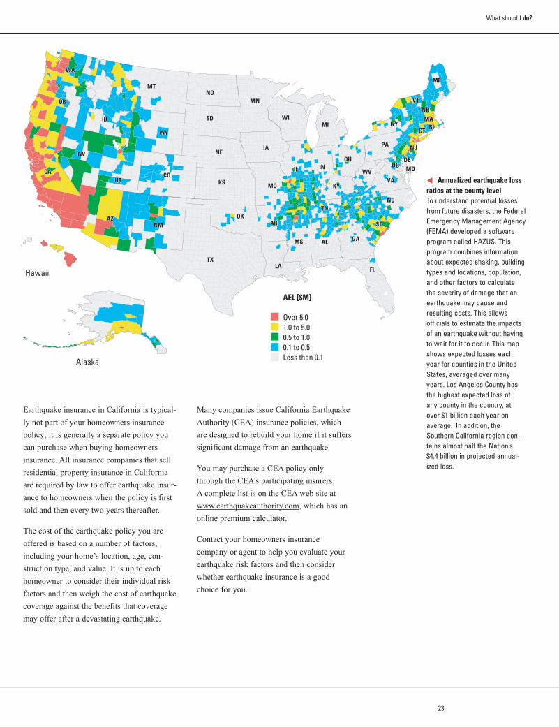
Annualized earthquake lossratios at the county levelTo understand potential lossesfrom future disasters, the FederalEmergency Management Agency(FEMA) developed a softwareprogram called HAZUS. This program combines informationabout expected shaking, buildingtypes and locations, population,and other factors to calculatethe severity of damage that anearthquake may cause andresulting costs. This allows officials to estimate the impactsof an earthquake without havingto wait for it to occur. This mapshows expected losses eachyear for counties in the UnitedStates, averaged over manyyears. Los Angeles County hasthe highest expected loss of any county in the country, atover $1 billion each year onaverage. In addition, theSouthern California region con-tains almost half the Nation’s$4.4 billion in projected annual-ized loss.
Earthquake insurance in California is typical-
ly not part of your homeowners insurance
policy; it is generally a separate policy you
can purchase when buying homeowners
insurance. All insurance companies that sell
residential property insurance in California
are required by law to offer earthquake insur-
ance to homeowners when the policy is first
sold and then every two years thereafter.
The cost of the earthquake policy you are
offered is based on a number of factors,
including your home’s location, age, con-
struction type, and value. It is up to each
homeowner to consider their individual risk
factors and then weigh the cost of earthquake
coverage against the benefits that coverage
may offer after a devastating earthquake.
Many companies issue California Earthquake
Authority (CEA) insurance policies, which
are designed to rebuild your home if it suffers
significant damage from an earthquake.
You may purchase a CEA policy only
through the CEA’s participating insurers.
A complete list is on the CEA web site at
www.earthquakeauthority.com, which has an
online premium calculator.
Contact your homeowners insurance
company or agent to help you evaluate your
earthquake risk factors and then consider
whether earthquake insurance is a good
choice for you.
k
24
rupture surface
fault plane
epicenter
hypocenter
fault line
Wha
t sho
uld
I kno
w?
EARTHQUAKES AND FAULTS
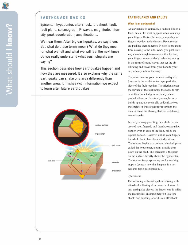
What is an earthquake?
An earthquake is caused by a sudden slip on a
fault, much like what happens when you snap
your fingers. Before the snap, you push your
fingers together and sideways. Because you
are pushing them together, friction keeps them
from moving to the side. When you push side-
ways hard enough to overcome this friction,
your fingers move suddenly, releasing energy
in the form of sound waves that set the air
vibrating and travel from your hand to your
ear, where you hear the snap.
The same process goes on in an earthquake.
Stresses in the earth’s outer layer push the
sides of the fault together. The friction across
the surface of the fault holds the rocks togeth-
er so they do not slip immediately when
pushed sideways. Eventually enough stress
builds up and the rocks slip suddenly, releas-
ing energy in waves that travel through the
rock to cause the shaking that we feel during
an earthquake.
Just as you snap your fingers with the whole
area of your fingertip and thumb, earthquakes
happen over an area of the fault, called the
rupture surface. However, unlike your fingers,
the whole fault plane does not slip at once.
The rupture begins at a point on the fault plane
called the hypocenter, a point usually deep
down on the fault. The epicenter is the point
on the surface directly above the hypocenter.
The rupture keeps spreading until something
stops it (exactly how this happens is a hot
research topic in seismology).
Aftershocks
Part of living with earthquakes is living with
aftershocks. Earthquakes come in clusters. In
any earthquake cluster, the largest one is called
the mainshock; anything before it is a fore-
shock, and anything after it is an aftershock.
E A R T H Q U A K E B A S I C S
Epicenter, hypocenter, aftershock, foreshock, fault,fault plane, seismograph, P-waves, magnitude, inten-sity, peak acceleration, amplification...
We hear them. After big earthquakes, we say them.But what do these terms mean? What do they meanfor what we felt and what we will feel the next time?Do we really understand what seismologists are saying?
This section describes how earthquakes happen andhow they are measured. It also explains why the sameearthquake can shake one area differently thananother area. It finishes with information we expect to learn after future earthquakes.
.
hypocenter
25
What should I know?
How do we study faults?Surface features that have been broken and
offset by the movement of faults are used to
determine how fast the faults move and thus
how often earthquakes are likely to occur. For
example, a streambed that crosses the San
Andreas fault near Los Angeles is now offset 83
meters (91 yards) from its original course. The
sediments in the abandoned streambed are
about 2,500 years old. If we assume movement
on the San Andreas has cut off that streambed
within the last 2,500 years, then the average
slip rate on the fault is 33 millimeters (1.3
inches) per year. This does not mean the fault
slips 33 millimeters each year. Rather, it stores
up 33 millimeters of slip each year to be
released in infrequent earthquakes. The last
earthquake offset the streambed another 5
meters (16 feet). If we assume that all earth-
quakes have 5 meters (5000 millimeters) of slip,
we will have earthquakes on average every 150
years: 5000 millimeters divided by 33 millime-
ters per year equals 150 years. This does not
mean the earthquakes will be exactly 150 years
apart. While the San Andreas fault has aver-
aged 150 years between events, earthquakes
have occurred as few as 45 years and as many
as 300 years apart.
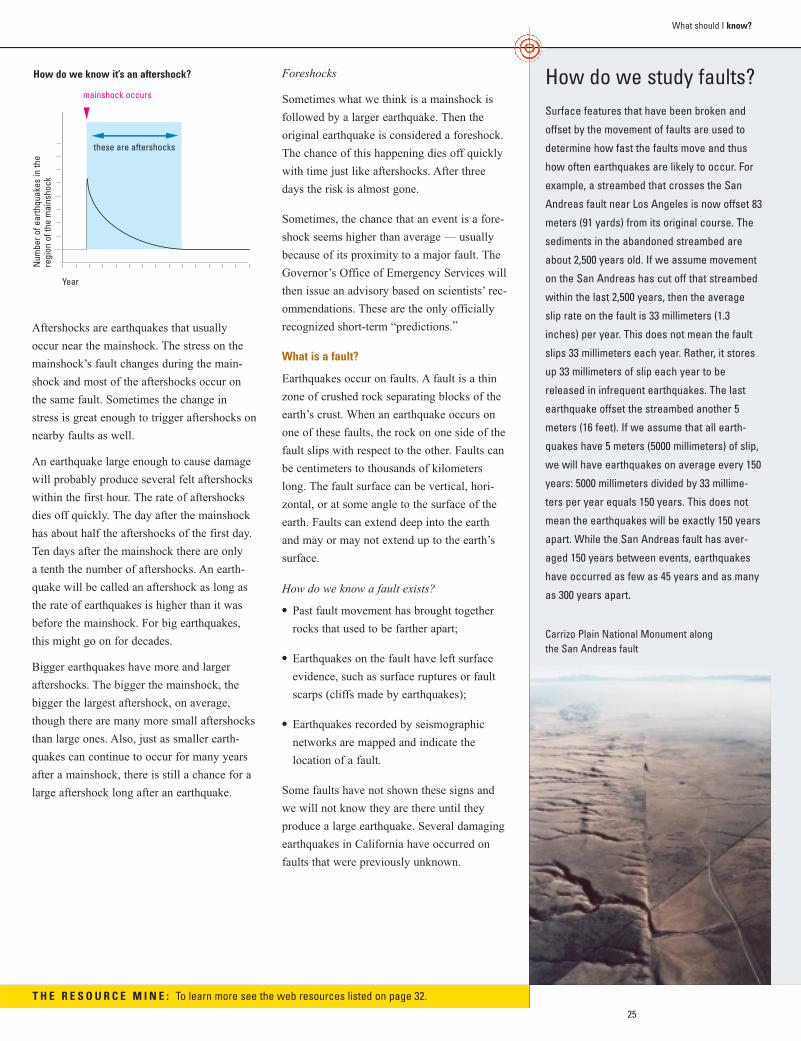
Aftershocks are earthquakes that usually
occur near the mainshock. The stress on the
mainshock’s fault changes during the main-
shock and most of the aftershocks occur on
the same fault. Sometimes the change in
stress is great enough to trigger aftershocks on
nearby faults as well.
An earthquake large enough to cause damage
will probably produce several felt aftershocks
within the first hour. The rate of aftershocks
dies off quickly. The day after the mainshock
has about half the aftershocks of the first day.
Ten days after the mainshock there are only
a tenth the number of aftershocks. An earth-
quake will be called an aftershock as long as
the rate of earthquakes is higher than it was
before the mainshock. For big earthquakes,
this might go on for decades.
Bigger earthquakes have more and larger
aftershocks. The bigger the mainshock, the
bigger the largest aftershock, on average,
though there are many more small aftershocks
than large ones. Also, just as smaller earth-
quakes can continue to occur for many years
after a mainshock, there is still a chance for a
large aftershock long after an earthquake.
Foreshocks
Sometimes what we think is a mainshock is
followed by a larger earthquake. Then the
original earthquake is considered a foreshock.
The chance of this happening dies off quickly
with time just like aftershocks. After three
days the risk is almost gone.
Sometimes, the chance that an event is a fore-
shock seems higher than average — usually
because of its proximity to a major fault. The
Governor’s Office of Emergency Services will
then issue an advisory based on scientists’ rec-
ommendations. These are the only officially
recognized short-term “predictions.”
What is a fault?
Earthquakes occur on faults. A fault is a thin
zone of crushed rock separating blocks of the
earth’s crust. When an earthquake occurs on
one of these faults, the rock on one side of the
fault slips with respect to the other. Faults can
be centimeters to thousands of kilometers
long. The fault surface can be vertical, hori-
zontal, or at some angle to the surface of the
earth. Faults can extend deep into the earth
and may or may not extend up to the earth’s
surface.
How do we know a fault exists?
• Past fault movement has brought together
rocks that used to be farther apart;
• Earthquakes on the fault have left surface
evidence, such as surface ruptures or fault
scarps (cliffs made by earthquakes);
• Earthquakes recorded by seismographic
networks are mapped and indicate the
location of a fault.
Some faults have not shown these signs and
we will not know they are there until they
produce a large earthquake. Several damaging
earthquakes in California have occurred on
faults that were previously unknown.
How do we know it’s an aftershock?
mainshock occurs
Year
these are aftershocks
Num
ber o
f ear
thqu
akes
in th
ere
gion
of t
he m
ains
hock
Carrizo Plain National Monument along the San Andreas fault
T H E R E S O U R C E M I N E : To learn more see the web resources listed on page 32.
26
Wha
t sho
uld
I kno
w? LOCATING AND
MEASURING EARTHQUAKES
Where and when was the earthquake?
Earthquakes are recorded by a seismic net-
work. Each seismic station in the network
measures the movement of the ground at that
site. In an earthquake, the slip of a block of
rock over another releases energy that makes
the ground vibrate. That vibration pushes the
adjoining piece of ground, causing it to
vibrate, and thus the energy travels out from
the earthquake in a wave. As the wave passes
by a seismic station, that piece of ground
vibrates and this vibration is recorded.
Earthquakes produce two main types of waves
— the P-wave (a compressional wave), and
the S-wave (a shear wave). The S-wave is
slower but larger than the P-wave and does
most of the damage. Scientists have used
knowledge of the differences between these
and other seismic waves to learn a great deal
about the interior of the earth.
Knowing how fast seismic waves travel
through the earth, seismologists can calculate
the time when the earthquake occurred and
its location by comparing the times when
shaking was recorded at several stations. This
process used to take almost an hour when
done manually.
Now computers determine this information
automatically within minutes. Within a few
more hours the shape and location of the
entire portion of the fault that moved can be
calculated.
We name earthquakes after map locations
near epicenters to have a convenient way to
refer to them, but this can be misleading.
We define the epicenter of an earthquake with
the latitude and longitude of a point, but the
earthquake is bigger than that point. The
fault’s rupture surface can be hundreds of
kilometers long and several kilometers wide,
and even the epicenter can only be determined
within a few tenths of a kilometer. Therefore,
giving the location of an earthquake in terms
of city streets is like giving the location of
your city by the address of City Hall.
How big was the earthquake?
Why do scientists have problems coming up
with a simple answer to this simple question?
Many people have felt this frustration after
earthquakes, as seismologists often seem to
contradict one another. In fact, earthquakes
are very complex. Measuring their size is
something like trying to determine the “size”
of an abstract modern sculpture with only one
use of a tape measure. Which dimension do
you measure?
Magnitude is the most common way of
describing an earthquake's size. In the 1930s,
Beno Gutenberg and Charles Richter at the
California Institute of Technology developed
a method to describe all sizes of earthquakes
using a small range of numbers. Using record-
ings from seismographs, they measured how
fast the ground moved at a set distance from
earthquakes. If the maximum acceleration of
the ground in one earthquake is 10 times the
maximum acceleration in another earthquake,
then the first earthquake is said to be one
unit of magnitude larger than the second. The
Richter Scale, as it became known, is not a
device, but the range of numbers used to
compare earthquakes.
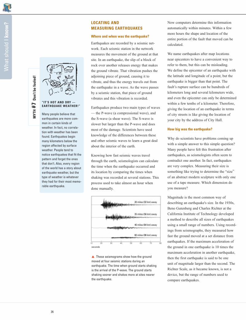
These seismograms show how the groundmoved at four seismic stations during an earthquake. The time when ground starts shaking is the arrival of the P-wave. The ground starts shaking sooner and shakes more at sites nearer the earthquake.
“IT’S HOT AND DRY —EARTHQUAKE WEATHER!”
Many people believe thatearthquakes are more com-mon in certain kinds ofweather. In fact, no correla-tion with weather has beenfound. Earthquakes beginmany kilometers below theregion affected by surfaceweather. People tend tonotice earthquakes that fit thepattern and forget the onesthat don’t. Also, every regionof the world has a story aboutearthquake weather, but thetype of weather is whateverthey had for their most memo-rable earthquake.
MYT
H#7
Don
’t be
fool
ed!
seconds
k
27
What should I know?
Seismologists have since developed a new
measurement of earthquake size, called
moment magnitude. Moment is a physical
quantity more closely related to the total
energy released in the earthquake than Richter
magnitude. It can be estimated by geologists
examining the geometry of a fault in the field
or by seismologists analyzing a seismogram.
Because the units of moment are very large, it
has been converted to the more familiar range
of magnitude values for communication to
the public.
Moment magnitude has many advantages over
other magnitude scales. First, all earthquakes
can be compared on the same scale. (Richter
magnitude is only precise for earthquakes of a
certain size and distance from a seismometer.)
Second, because it can be determined either
instrumentally or from geology, it can be
used to measure old earthquakes and compare
them to instrumentally recorded earthquakes.
Third, by estimating how large a section of
fault will likely move in the future, the mag-
nitude of that earthquake can be calculated
with confidence.
A magnitude 6.0 earthquake has about 32times more energy than a magnitude 5.0 and about 1,000 times more energy than amagnitude 4.0 earthquake. This does notmean there will be 1,000 times more shakingat your home. A bigger earthquake will lastlonger and release its energy over a muchlarger area.
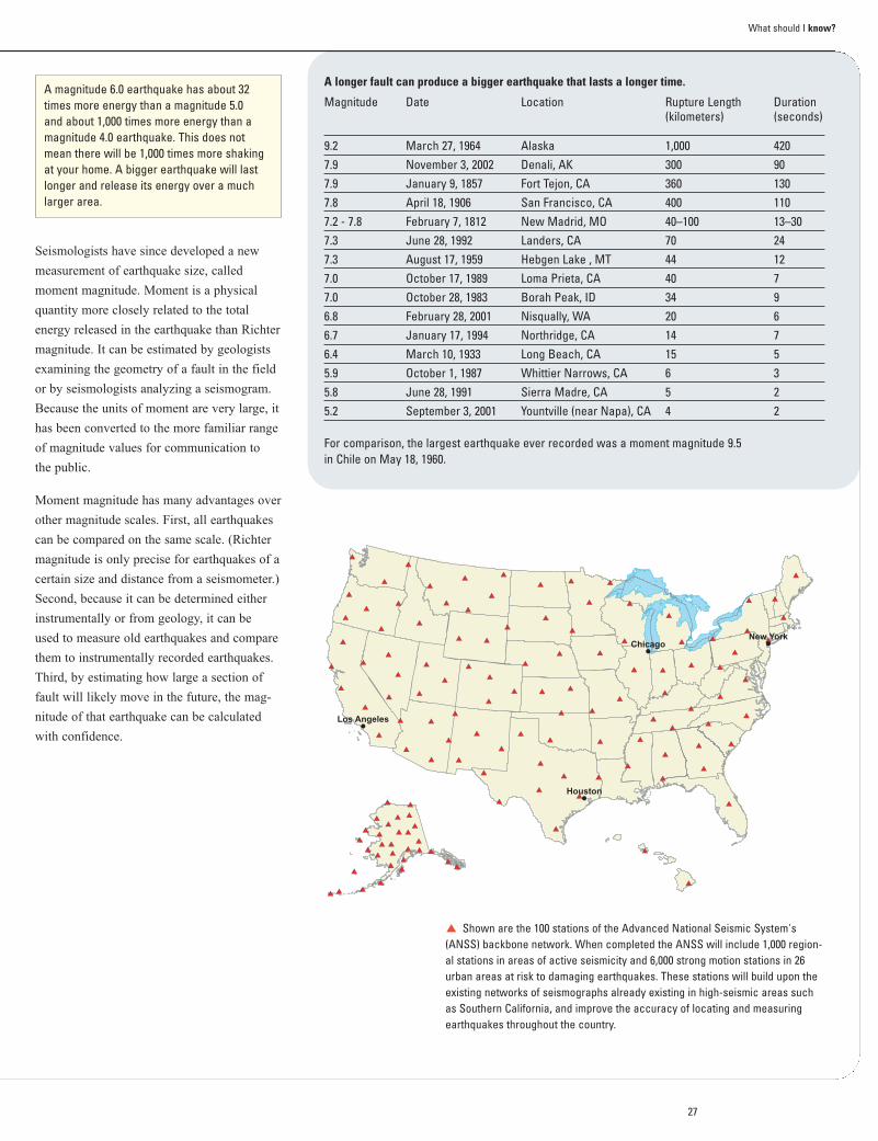
A longer fault can produce a bigger earthquake that lasts a longer time.
Magnitude Date Location Rupture Length Duration(kilometers) (seconds)
9.2 March 27, 1964 Alaska 1,000 4207.9 November 3, 2002 Denali, AK 300 907.9 January 9, 1857 Fort Tejon, CA 360 1307.8 April 18, 1906 San Francisco, CA 400 1107.2 - 7.8 February 7, 1812 New Madrid, MO 40–100 13–307.3 June 28, 1992 Landers, CA 70 247.3 August 17, 1959 Hebgen Lake , MT 44 127.0 October 17, 1989 Loma Prieta, CA 40 77.0 October 28, 1983 Borah Peak, ID 34 96.8 February 28, 2001 Nisqually, WA 20 66.7 January 17, 1994 Northridge, CA 14 76.4 March 10, 1933 Long Beach, CA 15 55.9 October 1, 1987 Whittier Narrows, CA 6 35.8 June 28, 1991 Sierra Madre, CA 5 25.2 September 3, 2001 Yountville (near Napa), CA 4 2
For comparison, the largest earthquake ever recorded was a moment magnitude 9.5 in Chile on May 18, 1960.
Shown are the 100 stations of the Advanced National Seismic System's(ANSS) backbone network. When completed the ANSS will include 1,000 region-al stations in areas of active seismicity and 6,000 strong motion stations in 26urban areas at risk to damaging earthquakes. These stations will build upon theexisting networks of seismographs already existing in high-seismic areas suchas Southern California, and improve the accuracy of locating and measuringearthquakes throughout the country.
k
Wha
t sho
uld
I kno
w?
28
EARTHQUAKE SHAKING
Magnitude is a measurement of the energy
produced by an earthquake and is not a mea-
sure of the shaking you feel. What you feel is
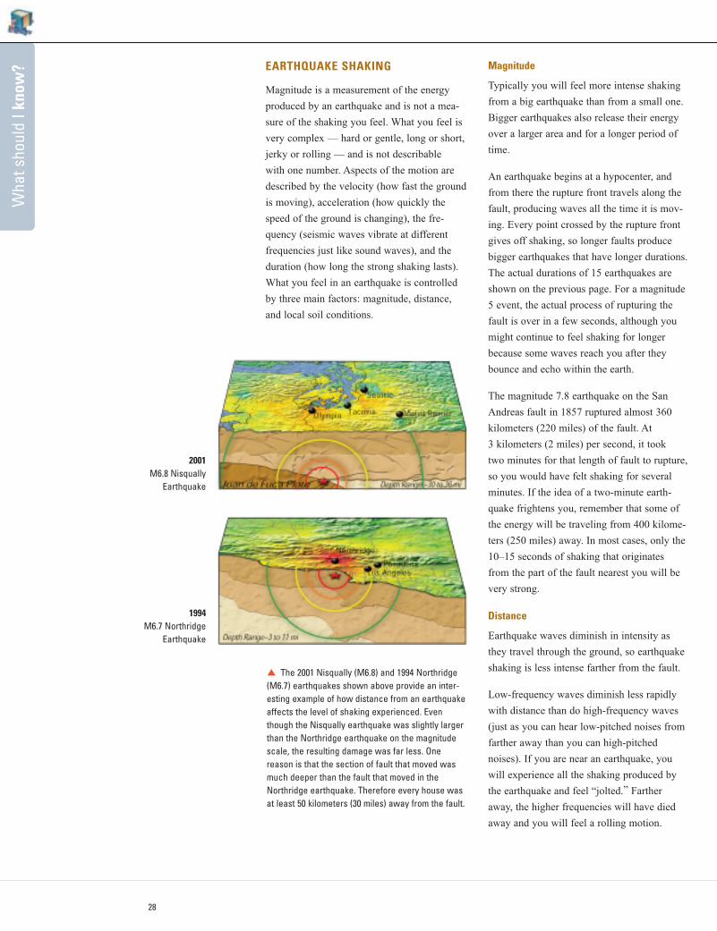
very complex — hard or gentle, long or short,
jerky or rolling — and is not describable
with one number. Aspects of the motion are
described by the velocity (how fast the ground
is moving), acceleration (how quickly the
speed of the ground is changing), the fre-
quency (seismic waves vibrate at different
frequencies just like sound waves), and the
duration (how long the strong shaking lasts).
What you feel in an earthquake is controlled
by three main factors: magnitude, distance,
and local soil conditions.
Magnitude
Typically you will feel more intense shaking
from a big earthquake than from a small one.
Bigger earthquakes also release their energy
over a larger area and for a longer period of
time.
An earthquake begins at a hypocenter, and
from there the rupture front travels along the
fault, producing waves all the time it is mov-
ing. Every point crossed by the rupture front
gives off shaking, so longer faults produce
bigger earthquakes that have longer durations.
The actual durations of 15 earthquakes are
shown on the previous page. For a magnitude
5 event, the actual process of rupturing the
fault is over in a few seconds, although you
might continue to feel shaking for longer
because some waves reach you after they
bounce and echo within the earth.
The magnitude 7.8 earthquake on the San
Andreas fault in 1857 ruptured almost 360
kilometers (220 miles) of the fault. At
3 kilometers (2 miles) per second, it took
two minutes for that length of fault to rupture,
so you would have felt shaking for several
minutes. If the idea of a two-minute earth-
quake frightens you, remember that some of
the energy will be traveling from 400 kilome-
ters (250 miles) away. In most cases, only the
10–15 seconds of shaking that originates
from the part of the fault nearest you will be
very strong.
Distance
Earthquake waves diminish in intensity as
they travel through the ground, so earthquake
shaking is less intense farther from the fault.
Low-frequency waves diminish less rapidly
with distance than do high-frequency waves
(just as you can hear low-pitched noises from
farther away than you can high-pitched
noises). If you are near an earthquake, you
will experience all the shaking produced by
the earthquake and feel “jolted.” Farther
away, the higher frequencies will have died
away and you will feel a rolling motion.
1994M6.7 Northridge
Earthquake
The 2001 Nisqually (M6.8) and 1994 Northridge(M6.7) earthquakes shown above provide an inter-esting example of how distance from an earthquakeaffects the level of shaking experienced. Eventhough the Nisqually earthquake was slightly largerthan the Northridge earthquake on the magnitudescale, the resulting damage was far less. One reason is that the section of fault that moved wasmuch deeper than the fault that moved in theNorthridge earthquake. Therefore every house wasat least 50 kilometers (30 miles) away from the fault.
2001M6.8 Nisqually
Earthquake
k
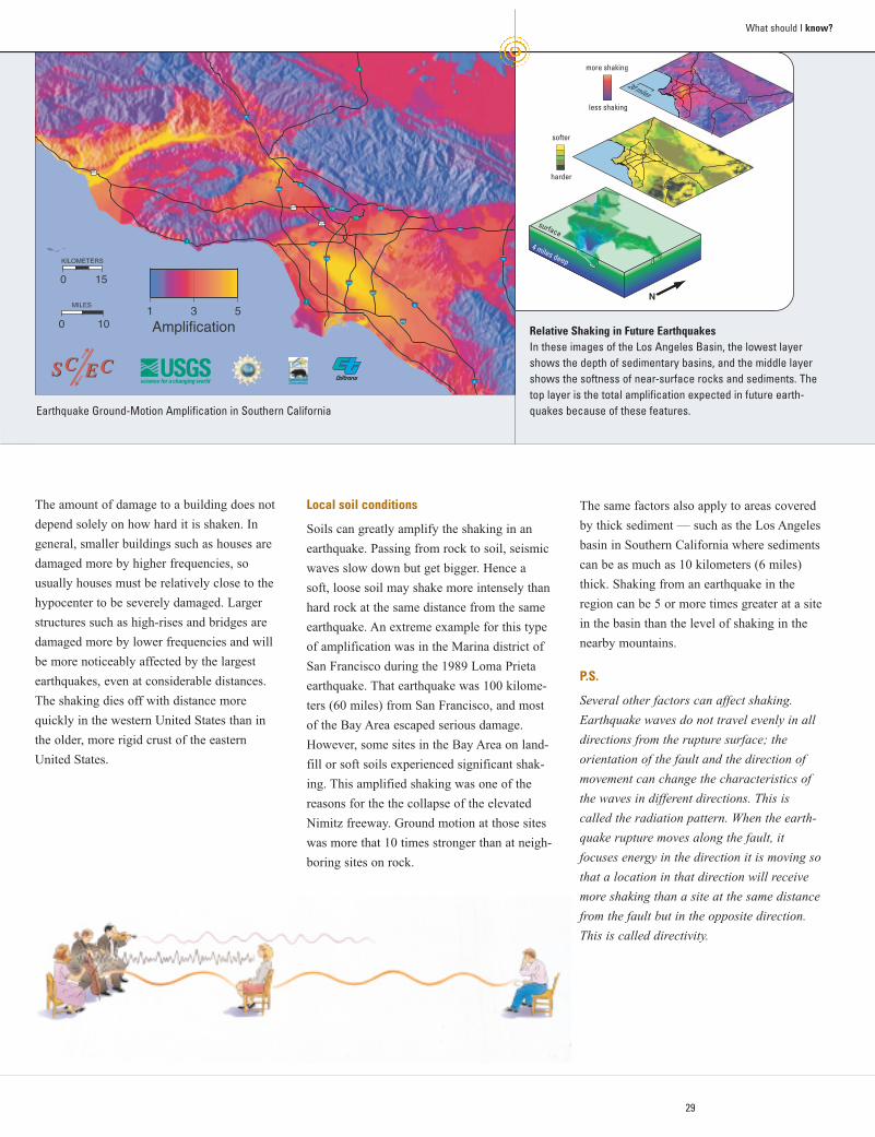
20 miles
more shaking
less shaking
harder
softer
N
surface
4 miles deep110
5
5
5
405
405
210
710
605
5
10
10
101
101
1
101
15
1
134
110
14
0 15
KILOMETERS
0 10
MILES1 3 5
Amplification
SC ECSC EC
29
What should I know?
The amount of damage to a building does not
depend solely on how hard it is shaken. In
general, smaller buildings such as houses are
damaged more by higher frequencies, so
usually houses must be relatively close to the
hypocenter to be severely damaged. Larger
structures such as high-rises and bridges are
damaged more by lower frequencies and will
be more noticeably affected by the largest
earthquakes, even at considerable distances.
The shaking dies off with distance more
quickly in the western United States than in
the older, more rigid crust of the eastern
United States.
Local soil conditions
Soils can greatly amplify the shaking in an
earthquake. Passing from rock to soil, seismic
waves slow down but get bigger. Hence a
soft, loose soil may shake more intensely than
hard rock at the same distance from the same
earthquake. An extreme example for this type
of amplification was in the Marina district of
San Francisco during the 1989 Loma Prieta
earthquake. That earthquake was 100 kilome-
ters (60 miles) from San Francisco, and most
of the Bay Area escaped serious damage.
However, some sites in the Bay Area on land-
fill or soft soils experienced significant shak-
ing. This amplified shaking was one of the
reasons for the the collapse of the elevated
Nimitz freeway. Ground motion at those sites
was more that 10 times stronger than at neigh-
boring sites on rock.
The same factors also apply to areas covered
by thick sediment — such as the Los Angeles
basin in Southern California where sediments
can be as much as 10 kilometers (6 miles)
thick. Shaking from an earthquake in the
region can be 5 or more times greater at a site
in the basin than the level of shaking in the
nearby mountains.
P.S.
Several other factors can affect shaking.
Earthquake waves do not travel evenly in all
directions from the rupture surface; the
orientation of the fault and the direction of
movement can change the characteristics of
the waves in different directions. This is
called the radiation pattern. When the earth-
quake rupture moves along the fault, it
focuses energy in the direction it is moving so
that a location in that direction will receive
more shaking than a site at the same distance
from the fault but in the opposite direction.
This is called directivity.
Earthquake Ground-Motion Amplification in Southern California
Relative Shaking in Future EarthquakesIn these images of the Los Angeles Basin, the lowest layershows the depth of sedimentary basins, and the middle layershows the softness of near-surface rocks and sediments. Thetop layer is the total amplification expected in future earth-quakes because of these features.
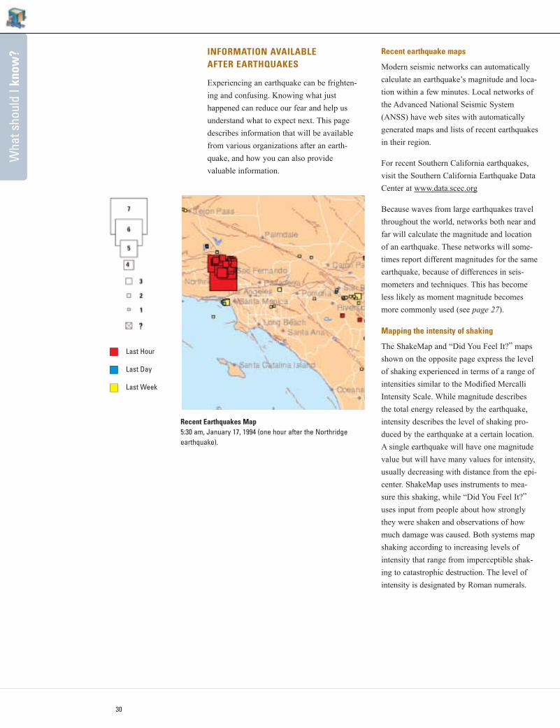
Wha
t sho
uld
I kno
w?
30
INFORMATION AVAILABLEAFTER EARTHQUAKES
Experiencing an earthquake can be frighten-
ing and confusing. Knowing what just
happened can reduce our fear and help us
understand what to expect next. This page
describes information that will be available
from various organizations after an earth-
quake, and how you can also provide
valuable information.
Recent earthquake maps
Modern seismic networks can automatically
calculate an earthquake’s magnitude and loca-
tion within a few minutes. Local networks of
the Advanced National Seismic System
(ANSS) have web sites with automatically
generated maps and lists of recent earthquakes
in their region.
For recent Southern California earthquakes,
visit the Southern California Earthquake Data
Center at www.data.scec.org
Because waves from large earthquakes travel
throughout the world, networks both near and
far will calculate the magnitude and location
of an earthquake. These networks will some-
times report different magnitudes for the same
earthquake, because of differences in seis-
mometers and techniques. This has become
less likely as moment magnitude becomes
more commonly used (see page 27).
Mapping the intensity of shaking
The ShakeMap and “Did You Feel It?” maps
shown on the opposite page express the level
of shaking experienced in terms of a range of
intensities similar to the Modified Mercalli
Intensity Scale. While magnitude describes
the total energy released by the earthquake,
intensity describes the level of shaking pro-
duced by the earthquake at a certain location.
A single earthquake will have one magnitude
value but will have many values for intensity,
usually decreasing with distance from the epi-
center. ShakeMap uses instruments to mea-
sure this shaking, while “Did You Feel It?”
uses input from people about how strongly
they were shaken and observations of how
much damage was caused. Both systems map
shaking according to increasing levels of
intensity that range from imperceptible shak-
ing to catastrophic destruction. The level of
intensity is designated by Roman numerals.
Last Hour
Last Day
Last Week
Recent Earthquakes Map5:30 am, January 17, 1994 (one hour after the Northridgeearthquake).
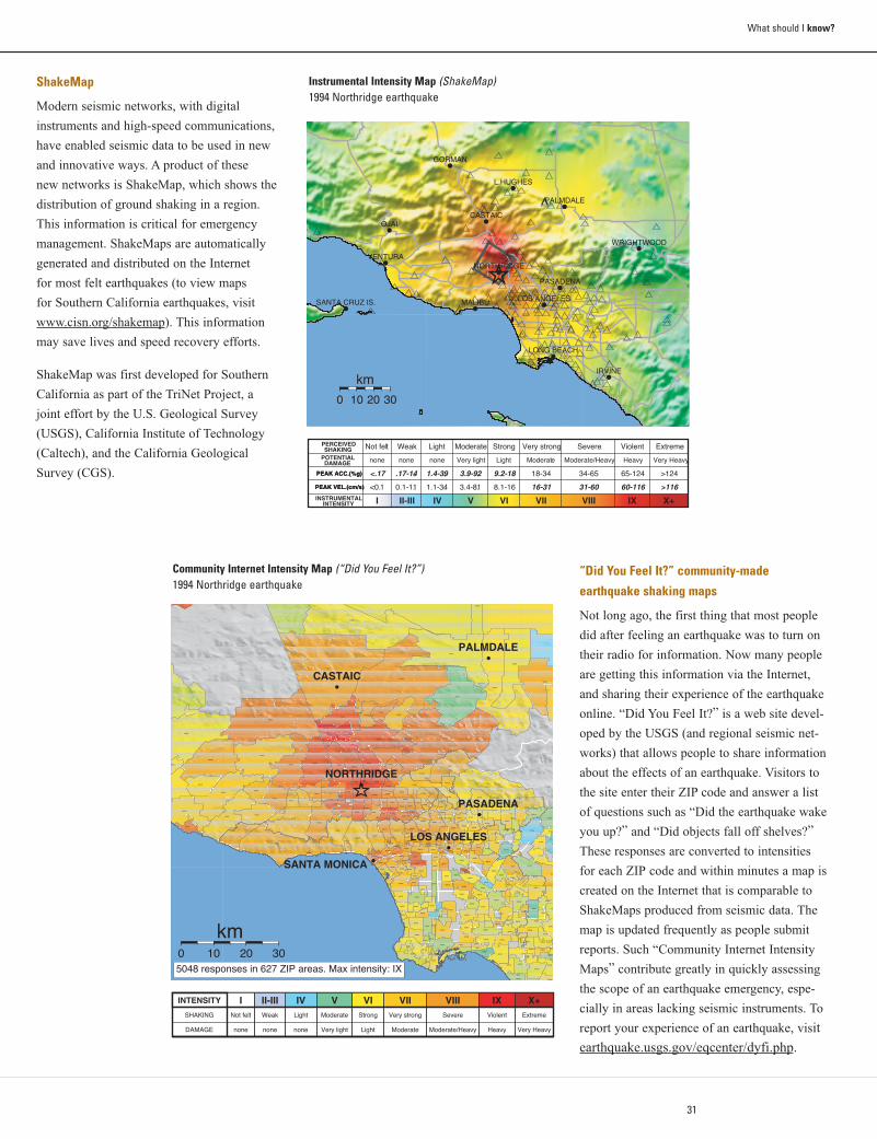
31
What should I know?
“Did You Feel It?” community-made
earthquake shaking maps
Not long ago, the first thing that most people
did after feeling an earthquake was to turn on
their radio for information. Now many people
are getting this information via the Internet,
and sharing their experience of the earthquake
online. “Did You Feel It?” is a web site devel-
oped by the USGS (and regional seismic net-
works) that allows people to share information
about the effects of an earthquake. Visitors to
the site enter their ZIP code and answer a list
of questions such as “Did the earthquake wake
you up?” and “Did objects fall off shelves?”
These responses are converted to intensities
for each ZIP code and within minutes a map is
created on the Internet that is comparable to
ShakeMaps produced from seismic data. The
map is updated frequently as people submit
reports. Such “Community Internet Intensity
Maps” contribute greatly in quickly assessing
the scope of an earthquake emergency, espe-
cially in areas lacking seismic instruments. To
report your experience of an earthquake, visit
earthquake.usgs.gov/eqcenter/dyfi.php.
INSTRUMENTAL INTENSITY
PEAK VEL.(cm/s) PEAK VEL.(cm/s)
PEAK ACC.(%g) PEAK ACC.(%g)
POTENTIAL DAMAGE
PERCEIVED SHAKING
I II-III IV V VI VII VIII IX X+
<0.1 0.1-1.1 1.1-3.4 3.4-8.1 8.1-16 16-31 31-60 60-116 >116
<.17 .17-1.4 1.4-3.9 3.9-9.2 9.2-18 18-34 34-65 65-124 >124
none none none Very light Light Moderate Moderate/Heavy Heavy Very Heavy
Not felt Weak Light Moderate Strong Very strong Severe Violent Extreme
.
Instrumental Intensity Map (ShakeMap)1994 Northridge earthquake
ShakeMap
Modern seismic networks, with digital
instruments and high-speed communications,
have enabled seismic data to be used in new
and innovative ways. A product of these
new networks is ShakeMap, which shows the
distribution of ground shaking in a region.
This information is critical for emergency
management. ShakeMaps are automatically
generated and distributed on the Internet
for most felt earthquakes (to view maps
for Southern California earthquakes, visit
www.cisn.org/shakemap). This information
may save lives and speed recovery efforts.
ShakeMap was first developed for Southern
California as part of the TriNet Project, a
joint effort by the U.S. Geological Survey
(USGS), California Institute of Technology
(Caltech), and the California Geological
Survey (CGS).
90001
90002
90004
90005
90006
90007
90008
90010
90011
90012
9001390015
90016
9001790019
90020
9002290023
90024
90025
90026
90027
90028
90029
90031 90032
90033
90034
90035
90036
90037
90038
90039
90041
90042
90043
9004490045
90046
90048
90049
90056
90057
90063
90064
90065
90066
90067
90068
90069
90077
90095
90201
90210
9021190212
90220
90230
90232
90240
90241
9024290245
90247
90248
90249
90250
90254
90255
90260
90262
90263
90265
90266
90270
90272
90274
90275
90277
90278
90280
90290
90291
90292
9029390301
90302
90303
90401
9040290403
90404
90405
90501 90502
90503
90504
90505
90601
90602
90603
90604
90605
90606
90620
90621
90623
90630
90631
90638
90640
90650
90660
90670
90680
90703
90706
90710
90712 90713
90715
90717 90720
90723
9073190732
90740
90742
90744
90745
90746
90802 90803
90804
90805
90806
90807
90808
90813
90814
90815
91001
91006
91007
91010
91011
91016
91020
91024
91030
91040
91042
91101
91103 91104
91105 91106
91107
91108
91201 91202
91203
91204 91205
91206
91207
91208
91214
91301
91302
91303
91304
9130691307
91311
91316
91320
91321
91324 91325
91326
91330
91331
91335
91340
91342
91343
91344
91345
91350
91351
91352
91354
91355
91356
91360
91361
91362
91364
91367
91377
91381
91384
91387
91390
91401
91402
91403
9140591406
91411
9142391436
91501
91502
91504
9150591506
91601
91602
91604
91605
91606
91607
9160891702
91706 91722
9
91732
91733
91744
91745
91748
9175491755
91770
91775
91776
91780
91790917
91801
91803
92626
92647
92648
92649
92655
9268392703
92704
92708
92801
92802
92804
92805
9283
92832
92833
92835
9284092841
9284392844
93004
93010
93012
93015
93021
93033
93042
93060
9306393065
93066
93510
93532
93534
93543
93550
93551
93552
93
CASTAIC
LOS ANGELES
NORTHRIDGE
PALMDALE
PASADENA
SANTA MONICA
5048 responses in 627 ZIP areas. Max intensity: IX
0 10 20 30
km
INTENSITY
SHAKING
DAMAGE
INot felt
none
II-IIIWeak
none
IVLight
none
VModerate
Very light
VIStrong
Light
VIIVery strong
Moderate
VIIISevere
Moderate/Heavy
IXViolent
Heavy
X+Extreme
Very Heavy
Community Internet Intensity Map (“Did You Feel It?”) 1994 Northridge earthquake
32
Why
sho
uld
I car
e?W
hat s
houl
d I d
o?W
hat s
houl
d I k
now
?
Why should I care? (Page 4)
Historic Earthquakes in Southern California clickable map:
www.data.scec.org/clickmap.html
Recent Earthquakes in Southern California: www.data.scec.org/recenteqs.html
Southern California clickable fault map: www.data.scec.org/faults/faultmap.html
California Geological Survey – Seismic Shaking Hazard Maps:
www.consrv.ca.gov/CGS/rghm/psha/pga.htm
Landslide and Liquefaction Maps for Southern California: gmw.consrv.ca.gov/shmp
What should I do? (Page 12)
Earthquake Country Alliance: www.daretoprepare.org
American Red Cross: www.redcross.org
California Earthquake Authority: www.earthquakeauthority.com
California Seismic Safety Commission: www.seismic.ca.gov
Emergency Survival Program (ESP): www.espfocus.org
California Office of Emergency Services: www.oes.ca.gov
Federal Emergency Management Agency: www.fema.gov
“Step 1” in greater detail: www.quakeinfo.org
What should I know? (Page 24)
United States Geological Survey Earthquake Hazards Program: earthquake.usgs.gov
California Geological Survey: www.consrv.ca.gov/cgs
Southern California Earthquake Center: www.scec.org
Southern California Earthquake Data Center: www.data.scec.org
Recent Earthquakes in Southern California: www.data.scec.org/recenteqs.html
Southern California ShakeMaps: www.cisn.org/shakemap
Did You Feel It? - report it!: earthquake.usgs.gov/eqcenter/dyfi.php
THE RESOURCE MINE
Answers for many of your questions, additional resources for the sections below,
and online versions of the Southern California and San Francisco Bay Region
editions of this handbook in multiple languages can be found at:
www.earthquakecountry.info
Additional funding provided by:
![Contents · “Putting Down Roots in Earthquake Country,” originally written by Lucy Jones (U.S. Geological Survey [USGS]) with later revisions by Mark Benthien (Southern California](https://static.fdocuments.net/doc/165x107/5fd42a0605fce134ee57cd16/contents-aoeputting-down-roots-in-earthquake-countrya-originally-written-by-lucy.jpg)