
PURPOSE AND NEED - MARC
32
Page | 1-1 Chapter 1: PURPOSE AND NEED This chapter of the Beyond the Loop Planning and Environmental Linkages (PEL) Study provides an overview and description of the corridor and identifies the transportation problems in the Study Area to be addressed by the proposed improvement strategies. The Purpose and Need identified in this chapter will move forward in subsequent National Environmental Policy Act (NEPA) studies prior to the determination of the final preferred alternative(s). PROJECT OVERVIEW The Mid-America Regional Council (MARC), in cooperation with the Federal Highway Administration (FHWA); Missouri Department of Transportation (MoDOT); City of Kansas City, Missouri (KCMO); Kansas Department of Transportation (KDOT); and the Unified Government of Wyandotte County/Kansas City, Kansas (UG) conducted a PEL study for an area that includes US-169/I-70/I-35/I-29/I-670 in Jackson and Clay counties, Missouri and Wyandotte County, Kansas. MARC and its partners conducted the PEL Study to assess the existing conditions, identify anticipated problem areas, and develop and evaluate transportation improvements to reduce congestion, enhance connectivity, and improve the safety of US-169 and I-70 within the Study Area. MARC prepared this PEL Study in accordance with FHWA guidance (Figure 1.1) for improving and streamlining the environmental process for transportation projects by conducting planning activities before the start of the NEPA process. The PEL Study focuses on the development of a strategic plan that identifies and evaluates reasonable alternatives for the US-169 corridor, including access connections to the Charles B. Wheeler Downtown Airport, replacement or rehabilitation of the Buck O’Neil Bridge (O’Neil Bridge), and the connection to the 5th/6th Street interchange. The study will also focus on the I-70 corridor from US-71 on the east to I-670 on the west, including its connection to the US-169 corridor and downtown loop, MO-9 to the Heart of America Bridge, improvement of traffic flow, and better connection of the street grid between the River Market and Downtown Kansas City. Additional issues being considered as part of this study include: • Access to the Port of Kansas City • Airspace use and potential airspace obstructions around the Downtown Airport • Missouri River navigation • Bicycle and pedestrian accommodations on major bridges • Impacts to transit and railroads • Recommendations and plans from KDOT’s Lewis and Clark Viaduct Study • Potential downtown interstate access and routing The proposed improvements will address issues associated with future access, mobility, safety, system preservation, and redevelopment. SUMMARY OF STUDY GOALS In 2015, MARC formally adopted its metropolitan transportation plan for Greater Kansas City — Transportation Outlook 2040. The updated transportation plan provides a policy framework for the investment of federal, state, and local funds based on anticipated needs and regional goals and objectives.
Transcript of PURPOSE AND NEED - MARC

Page | 1-1
Chapter 1:PURPOSE AND NEEDThis chapter of the Beyond the Loop Planning and Environmental Linkages (PEL) Study provides an overview and description of the corridor and identifi es the transportation problems in the Study Area to be addressed by the proposed improvement strategies. The Purpose and Need identifi ed in this chapter will move forward in subsequent National Environmental Policy Act (NEPA) studies prior to the determination of the fi nal preferred alternative(s).
PROJECT OVERVIEW The Mid-America Regional Council (MARC), in cooperation with the Federal Highway Administration (FHWA); Missouri Department of Transportation (MoDOT); City of Kansas City, Missouri (KCMO); Kansas Department of Transportation (KDOT); and the Unifi ed Government of Wyandotte County/Kansas City, Kansas (UG) conducted a PEL study for an area that includes US-169/I-70/I-35/I-29/I-670 in Jackson and Clay counties, Missouri and Wyandotte County, Kansas.
MARC and its partners conducted the PEL Study to assess the existing conditions, identify anticipated problem areas, and develop and evaluate transportation improvements to reduce congestion, enhance connectivity, and improve the safety of US-169 and I-70 within the Study Area. MARC prepared this PEL Study in accordance with FHWA guidance (Figure 1.1) for improving and streamlining the environmental process for transportation projects by conducting planning activities before the start of the NEPA process.
The PEL Study focuses on the development of a strategic plan that identifi es and evaluates reasonable alternatives for the US-169 corridor, including access connections to the Charles B. Wheeler Downtown Airport, replacement or rehabilitation of the Buck O’Neil Bridge (O’Neil Bridge), and the connection to the 5th/6th Street interchange. The study will also focus on the I-70 corridor from US-71 on the east to I-670 on the west, including its connection to the US-169 corridor and downtown loop, MO-9 to the Heart of America Bridge, improvement of traffi c fl ow, and better connection of the street grid between the River Market and Downtown Kansas City. Additional issues being considered as part of this study include:
• Access to the Port of Kansas City
• Airspace use and potential airspace obstructions around the Downtown Airport
• Missouri River navigation
• Bicycle and pedestrian accommodations on major bridges
• Impacts to transit and railroads
• Recommendations and plans from KDOT’s Lewis and Clark Viaduct Study
• Potential downtown interstate access and routing
The proposed improvements will address issues associated with future access, mobility, safety, system preservation, and redevelopment.
SUMMARY OF STUDY GOALSIn 2015, MARC formally adopted its metropolitan transportation plan for Greater Kansas City — Transportation Outlook 2040. The updated transportation plan provides a policy framework for the investment of federal, state, and local funds based on anticipated needs and regional goals and objectives.
Page | 1-2
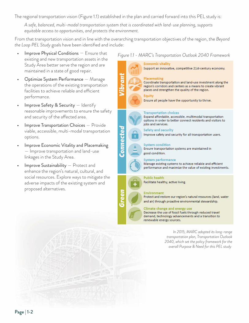
The regional transportation vision (Figure 1.1) established in the plan and carried forward into this PEL study is:
A safe, balanced, multi-modal transportation system that is coordinated with land-use planning, supports
equitable access to opportunities, and protects the environment.
From that transportation vision and in line with the overarching transportation objectives of the region, the Beyond
the Loop PEL Study goals have been identifi ed and include:
• Improve Physical Conditions — Ensure that existing and new transportation assets in the Study Area better serve the region and are maintained in a state of good repair.
• Optimize System Performance — Manage the operations of the existing transportation facilities to achieve reliable and effi cient performance.
• Improve Safety & Security — Identify reasonable improvements to ensure the safety and security of the aff ected area.
• Improve Transportation Choices — Provide viable, accessible, multi-modal transportation options.
• Improve Economic Vitality and Placemaking — Improve transportation and land-use linkages in the Study Area.
• Improve Sustainability — Protect and enhance the region’s natural, cultural, and social resources. Explore ways to mitigate the adverse impacts of the existing system and proposed alternatives.
In 2015, MARC adopted its long-range
transportation plan, Transportation Outlook
2040, which set the policy framework for the
overall Purpose & Need for this PEL study.
Figure 1.1 - MARC’s Transportation Outlook 2040 Framework

Page | 1-3
STUDY PURPOSEThe study purpose is to seek the most eff ective approach to improving the transportation facilities in the Study Area, including the development of alternative strategies, which, when implemented, will meet the identifi ed current and future needs, while balancing the interests of the various stakeholders.
For this study, the interests of the stakeholders can be grouped into three distinct groups:
• Federal/State — The federal interest includes maintaining the viability of the interstate highway system for long-distance travel. The state interest includes improving the condition of the transportation assets on the state highway network in both Missouri and Kansas, providing opportunities for improving the movement of goods, and improving the travel conditions for long-distance travel.
• Regional — The regional interest includes improving the ability of the traveling public to access the Central Business District (CBD) and other regional destinations for work, services, recreation, or commerce, as well as maintaining access to critical infrastructure and industry.
• Local — The local interest includes improving the economic viability of the downtown core in both Missouri and Kansas, including adjacent neighborhoods and economic centers, through improved accessibility, modal options, and environmental sustainability.
STUDY NEEDSWithin the context of the overarching study goals, the PEL process included the development of specifi c study needs. In this case, the fi rst three project goals — Improve Physical Conditions, Optimize System Performance, and Improve Safety and Security — serve as the overarching project needs. By defi nition, these needs must be resolved by the selected alternative strategy(ies). The last three project goals — Improve Transportation Choices, Improve Economic Vitality and Placemaking, and Improve Sustainability — will then help distinguish between the remaining improvement strategies. Finally, additional evaluation criteria have been established to provide a framework for selecting the fi nal proposed strategy(ies) to carry into the NEPA decision-making process. More specifi cally, the study process includes three screening levels:
Screening Level 1 — Does the proposed strategy address the Purpose and Need for the project?• Need 1: Improve Physical Conditions — Does it improve the condition of the O’Neil Bridge, the US-169
Corridor, or the I-70 North Loop?
• Need 2: Optimize System Performance — Does the strategy improve regional multi-modal connectivity or improve traffi c operations?
• Need 3: Improve Safety and Security — Does the improvement provide for the safe operation of vehicular traffi c, improve safety for bicyclists and pedestrians, or improve emergency response times and provide improved system redundancy?
Screening Level 2 — Does the proposed strategy address the project goals?• Goal 1: Improve Transportation Choices — Does the strategy provide for bicyclist and pedestrian opportunities
or improve transit accessibility?
• Goal 2: Improve Economic Vitality and Placemaking — Does the improvement provide for additional economic development opportunities, enhance regional freight movements, or promote quality places?
• Goal 3: Improve Sustainability — Does the improvement promote social equity and neighborhood revitalization, minimize impacts to historical and natural environmental resources, or integrate new transportation technologies?
Screening Level 3 — Which proposed strategy best meets the Purpose & Need, the Project Goals, and the additional evaluation criteria provided in the Screening Methodologies Technical Memorandum?

Page | 1-4
PROJECT STUDY AREAThe Area of Infl uence (Study Area) is generally defi ned by the US-169/MO Route 9 interchange to the north, I-670 to the south, the I-70/670 interchange in Wyandotte County, Kansas, to the west, and the I-70/ I-670/US-71 interchange in Jackson County, Missouri, to the east. The project Study Area extends to areas immediately adjacent to these corridors that are directly benefi ted/impacted by the corridors.
TRAFFIC ANALYSIS AREABecause several of the proposed improvement strategies could potentially infl uence travel patterns outside the primary Study Area, the boundaries were extended for the traffi c analysis to include I-635 on the west, I-435 on the east, US-50/Shawnee Mission Parkway on the south, and I-29/I-35 on the north.
Figure 1.2 - PEL Study Area and Traffi c Analysis Area

Page | 1-5
Project Need #1: IMPROVE PHYSICAL CONDITIONSNEED 1.1 — BUCK O’NEIL BRIDGE
History of the BridgeThe US-169 Bridge is a triple-span, tied-through arch bridge carrying four lanes of traffi c over the Missouri River, providing access to the Kansas City, Missouri, CBD, and areas north of the river, including the Charles B. Wheeler Downtown Airport, and Clay and Platte counties in Missouri. Construction was completed at a cost of $12 million, and the bridge was opened to traffi c on September 9, 1956 as the Broadway Bridge. Originally owned and maintained by the City of Kansas City, Missouri, as a toll bridge, the structure was taken into the MoDOT system in 1991 as part of US-169 and the toll removed.
The bridge lies just west, or upstream, of the Second Hannibal Bridge, a railroad bridge constructed in 1917, which carried a second level for auto traffi c above the rail deck. Upon completion of the US-169 bridge, traffi c was switched, and the upper level of the Hannibal Bridge was decommissioned.
On June 24, 2016, the bridge was offi cially renamed from the Broadway Bridge to the Buck O’Neil Bridge in honor of the Kansas City Monarchs player and manager, John Jordan “Buck” O’Neil.
Bridge ConditionMoDOT completed an extensive inspection of the O’Neil Bridge in July 2015. The inspection identifi ed numerous structural defi ciencies in need of rehabilitation. Signifi cant deterioration of structural elements such as steel stringers and bearings has occurred due to roadway drainage exposure. These elements need to be repaired or replaced, and deck replacement will be required to minimize this type of damage in the future. In addition, hanger cable retainers are missing, gusset plates and structural members are exhibiting pack rust, expansion joints need to be replaced, and some fatigue cracking is evident. Approach spans have fatigue cracking and similar pack rust and corrosion issues. The center river pier has a large scour hole on all sides and at this point is only embedded in one foot of shale. Repainting of the entire bridge, as well as repairs to the tie beams, lower laterals, fl oor beams and bridge railings, have been proposed. Scour countermeasures have been suggested at the center river pier to protect against further undermining.
Committed ProjectsIn March 2017, MoDOT completed a conceptual study of the repair and rehabilitation of the O’Neil Bridge. The study included a detailed inspection of the bridge and its approach structures. Four improvement scenarios were evaluated: a short-term repair option, a long-term repair option, a “hybrid” of short- and long-term, and a second
The existing O’Neil Bridge was originally opened to traffi c in 1956 making it two years
younger than the Paseo Bridge which was replaced in 2011.

Page | 1-6
“hybrid” that included some span replacements. An alternate for replacement in-kind was also evaluated to serve as a baseline. Based on the results of this conceptual study, MoDOT recommended the long-term rehabilitation option as the preferred approach.After further discussion with regional leaders and concerned stakeholders, MoDOT agreed to instead complete a shorter term rehabilitation to allow time for the study to conclude, funding to be allocated, and the NEPA process to start on a potential replacement structure. That shorter term rehabiliation has been let for construction and is currently being completed.
Project NeedProvide a long-term solution for improving the existing condition of the O’Neil Bridge.
MoDOT recently completed a detailed inspection of
the bridge, including the main span and the ap-
proach structures, and identifi ed signifi cant structural
defi ciencies that need to be addressed through either
replacement or a long-term rehabilitation.

Page | 1-7
NEED 1.2 — US-169 CORRIDOR
History of the CorridorThe Second Hannibal Bridge, opened in 1917, originally carried both vehicular traffi c on the top deck and rail traffi c on the lower deck. After construction of the new O’Neil Bridge was completed in 1956, vehicular traffi c was removed from the top deck and switched to the new bridge. The bridge was originally built to provide access to the Downtown Airport and later extended to provide an important access to northern Kansas City. The corridor continues to provide regional connectivity for the Northland, including access to Kansas City International Airport. In addition to the bridge, there are several additional facilities in need of improvement in the US-169 corridor.
4th, 5th, 6th Streets and I-70When the original O’Neil Bridge was constructed, the approach spans were integrated into the existing street net-work at 4th, 5th, and 6th Streets, including an interchange with I-70. In fact, access from 4th Street to Broadway is accomplished through a southbound lane in between the two approach structures. This geometric defi ciency, coupled with the tight spacing between 5th, 6th, and I-70, have created a need to improve the overall confi guration of this segment of Broadway Boulevard.
5th Street
4th Street
3rd Street
Just south of the O’Neil Bridge, travelers
are required to traverse through the 4th
and 5th Street intersection with its unique
geometric confi guration. As illustrated in
the picture above, southbound traffi c from
River Market is forced to access Broadway
Boulevard between the northbound and
southbound traffi c heading to the O’Neil
Bridge. The substandard confi guration
leads to driver confusion and an unsafe
driving environment.
Woodswether BridgeUnder the existing O’Neil Bridge, the Woodswether Bridge provides important access between the River Market and the industrial West Bottoms District. The condition rating for this structure is poor and it needs to be replaced. The City of Kansas City, Missouri, has completed a small rehabilitation project to enable the bridge to stay open in the short term, pending a decision on the future of the O’Neil Bridge.
Downtown Airport Interchange
The original O’Neil Bridge provided needed access to the Downtown Airport. Later improvements to extend US-169 to the north were integrated into the existing airport intersection. The intersection also provides access across
Woodswether Bridge
Page | 1-8
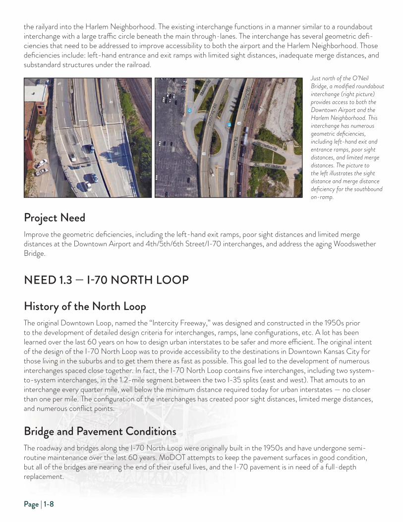
the railyard into the Harlem Neighborhood. The existing interchange functions in a manner similar to a roundabout interchange with a large traffi c circle beneath the main through-lanes. The interchange has several geometric defi -ciencies that need to be addressed to improve accessibility to both the airport and the Harlem Neighborhood. Those defi ciencies include: left-hand entrance and exit ramps with limited sight distances, inadequate merge distances, and substandard structures under the railroad.
Project NeedImprove the geometric defi ciencies, including the left-hand exit ramps, poor sight distances and limited merge distances at the Downtown Airport and 4th/5th/6th Street/I-70 interchanges, and address the aging Woodswether Bridge.
NEED 1.3 — I-70 NORTH LOOP
History of the North LoopThe original Downtown Loop, named the “Intercity Freeway,” was designed and constructed in the 1950s prior to the development of detailed design criteria for interchanges, ramps, lane confi gurations, etc. A lot has been learned over the last 60 years on how to design urban interstates to be safer and more effi cient. The original intent of the design of the I-70 North Loop was to provide accessibility to the destinations in Downtown Kansas City for those living in the suburbs and to get them there as fast as possible. This goal led to the development of numerous interchanges spaced close together. In fact, the I-70 North Loop contains fi ve interchanges, including two system-to-system interchanges, in the 1.2-mile segment between the two I-35 splits (east and west). That amouts to an interchange every quarter mile, well below the minimum distance required today for urban interstates — no closer than one per mile. The confi guration of the interchanges has created poor sight distances, limited merge distances, and numerous confl ict points.
Bridge and Pavement ConditionsThe roadway and bridges along the I-70 North Loop were originally built in the 1950s and have undergone semi-routine maintenance over the last 60 years. MoDOT attempts to keep the pavement surfaces in good condition, but all of the bridges are nearing the end of their useful lives, and the I-70 pavement is in need of a full-depth replacement.
Just north of the O’Neil
Bridge, a modifi ed roundabout
interchange (right picture)
provides access to both the
Downtown Airport and the
Harlem Neighborhood. This
interchange has numerous
geometric defi ciencies,
including left-hand exit and
entrance ramps, poor sight
distances, and limited merge
distances. The picture to
the left illustrates the sight
distance and merge distance
defi ciency for the southbound
on-ramp.

Page | 1-9
• Bridges — Of the 21 bridge structures on the I-70 North Loop, 14 are listed in “fair” condition, with the remaining seven listed in “good” condition. None of the structures are listed in “poor” condition.
• Roadway — Approximately 75 to 95 percent of the pavement along I-70 between the northwest corner and the southeast corner of the downtown loop is in good condition. The connections into this segment of I-70 fare much worse from a pavement condition perspective. For example, sections of I-35 in good condition on the west side of the loop ranges from 47 to 100 percent ; I-29/35 north of the loop ranges from 0 to 60 percent; and US-169 ranges from 7 to 40 percent. In addition, these percentages merely refl ect the condition of the pavement surface. Considering the age of the facility, the underlying pavement conditions are expected to be signifi cantly worse.
Geometric Defi cienciesThe I-70 North Loop was built in the 1950s and does not meet FHWA geometric standards for urban interstates. Existing geometric defi ciencies along this section of I-70 include:
• Shoulder Widths — Narrow inside and outside shoulder widths inadequate to safely accommodate stranded motorists.
• Exit and Entrance Ramps — Exit ramps that are too short to safely allow motorists to exit, and short merge distances from the entrance ramps insuffi cient to allow safe merging with mainline I-70 traffi c.
• Lane Continuity — The corridor lacks reasonable lane balance, forcing vehicles to merge across lanes, which adds to driver confusion and reduces safety.
Project NeedImprove the geometric defi ciencies, and overall condition of the roadway and bridges, on the I-70 North Loop.
5th Street
6th Street
I-70
Broa
dway
Wya
ndot
te S
t.
Dela
ware
St.
Waln
ut S
t.
Gra
nd B
lvd.
The original I-70 North Loop was built in the 1950s and does not meet FHWA design standards. The Missouri section of I-70 has fi ve interchanges
including three system-to-system interchanges in a 1.2-mile stretch. The aerial above identifi es each of the ramp movements required to accommo-
date these fi ve interchanges.

Page | 1-10
Project Need #2: OPTIMIZE SYSTEM PERFORMANCENEED 2.1 — REGIONAL CONNECTIONSThe Kansas City, Missouri, CBD continues to be a major regional destination for employment, recreation, arts/culture, entertainment, and dining. Vehicular access to downtown is currently accomplished through a network of urban highways, including I-35 to the northeast and southwest, I-70 to the east and west, US-169 and Route 9 to the north, and US-71 to the south. The performance of this network of highways accessing the Downtown Loop has become increasingly congested.
Kansas City NorthlandThe Kansas City Northland, including both Clay and Platte counties in Missouri, has experienced extensive growth over the last several decades, including numerous large-scale residential developments. The growth has resulted in an increase in vehicular traffi c entering the Kansas City CBD on a daily basis. Access to the Northland from the CBD occurs either across the O’Neil Bridge and up US-169, across the Heart of America Bridge and through North Kansas City, or across the Bond Bridge and up I-35/29. About half of the Northland traffi c uses the Bond Bridge, while the O’Neil Bridge and Heart of America Bridge comprise about 25 percent each.
Wyandotte and Johnson CountiesTo the west, Wyandotte County and northern Johnson County are accessed via I-70, and southern Johnson County is accessed via I-35. Signifi cant developments in western Wyandotte County, such as the new Amazon distribution facility and the Legends shopping center, have resulted in a continued increase in traffi c along I-70. The continued growth in Johnson County has resulted in traffi c volume increases on both I-70 and I-35. About half the traffi c heading west on I-70 takes the I-70 North Loop to the merge with I-670, while the other half uses I-670. For those heading south to southern Johnson County, the primary route is I-35. This southerly route along I-35 represents the largest traffi c movement in and out of the CBD on a daily basis, followed closely by I-70 to the east.
Jackson CountyTo the east, residents living in Jackson County use either I-70 or US-71. Continued growth in Blue Springs, Grain Valley, and Lee’s Summit have put pressure on the I-70 corridor to the east, and growth in western Lee’s Summit, Belton, and Raymore continue to add traffi c to the US-71 corridor. About 40 percent of the traffi c coming in and out of the CBD from Jackson County is headed south on US-71, with the remaining 60 percent heading east on I-70.
Project NeedImprove the high levels of traffi c congestion and travel delays along the primary highway facilities serving the CBD within the Study Area.
Page | 1-11
NEED 2.2 — TRAFFIC OPERATIONSThe large volume of traffi c using the existing Downtown Loop on a daily basis, coupled with a freeway system designed and constructed over 50 years ago, has resulted in a signifi cant level of traffi c congestion, large traffi c queues trying to access the CBD, long delays, and poor levels of service. Typical sources of congestion in the Study Area are high traffi c volumes coupled with transportation system restrictions. Existing Study Area restrictions include:
• Weave Areas — Where two or more roadway paths cross, resulting in the need to merge across multiple lanes in relatively short distances.
• Merge — Where one or more lanes are eliminated, requiring traffi c to occupy a reduced number of lanes.
• On and Off Ramps — Several ramps located in close proximity, resulting in short distances to enter and exit at these ramp locations.
• Lane Continuity — The inability of traffi c to stay in the same lane, requiring a driver to change lanes to stay on a given route.
• Substandard Design Criteria — The original facility was designed with criteria that is over 50 years old, when requirements for certain elements (curvature, site distance, super-elevation, etc.) did not take into account higher speeds and larger volumes of traffi c.
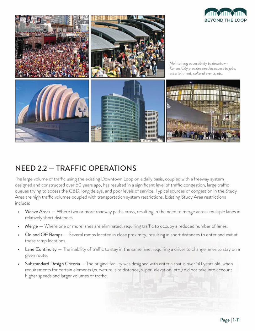
Maintaining accessibility to downtown
Kansas City provides needed access to jobs,
entertainment, cultural events, etc.

Page | 1-12
Operational Defi cienciesTraffi c congestion is traditionally evaluated based on the levels of service (LOS) criteria, ranging from A to F, where LOS A refers to free fl ow, unimpeded traffi c and LOS F refers to gridlock. The roadway corridors in the Study Area were evaluated from a LOS perspective, as well as using the average travel speeds. The density map on the next page shows the LOS hot spots located within the Study Area. The physical characteristics of the Downtown Loop, many of which were designed 50 years ago, are the source of both congestion and safety issues (Figure 1.3). The facilities with poor service levels during either the morning or afternoon peak period include:
• US-169 — The US-169 interchange with I-70 currently accommodates two diff ering purposes: getting US-169 traffi c to the interstate system via either I-35 or I-70 and providing access to and from downtown. Traffi c is evenly split between these two purposes, but the overall volumes are large, and they are both competing for the same space. The competition results in daily congestion in several diff erent directions:
- Southbound US-169 queues, from 5th Street north across the Broadway Bridge, regularly exceed a mile.
- Northbound I-35 queues, on the off -ramp to Broadway, regularly extend well beyond the 6th Street and I-35 off -ramp gore at Washington Street.
- Northbound Broadway queues regularly extend from 5th Street south through 6th Street and well into Downtown.
- Westbound 5th Street queues at Broadway regularly extend beyond the 5th Street, I-70 off -ramp merge point.
Based on the regional travel demand modeling, there is a signifi cant “pent-up demand” for use of the interchange. If the current delays at the interchange are reduced, signifi cant volumes of traffi c will divert from I-635, Route 9, I-35/I-29 and the east side of I-435.
• I-70 — In the evening peak period, the east side of the downtown loop experiences backups in the northbound direction that often extend all the way to the southern I-670 leg of the loop. Backups also occur in the southbound direction in the morning commute as travelers cross the Bond Bridge and enter the CBD. In addition, individual ramps along the north loop of I-70 experience backups in both the morning and evening peak periods because of substandard storage and merge distances.
• I-670 — During the morning commute, westbound I-670 experiences poor levels of service due primarily to the merge requirements to access Broadway and to position to head south on I-35 or west on I-70. Similarly, the afternoon peak shows poor LOS in the eastbound direction, especially under Bartle Hall where mainline I-670 narrows to one lane.
Project NeedImprove the traffi c operation, through improved levels of service and reduced delay, along both US-169 and I-70 in the Downtown Loop.

Page | 1-13
Existing AM Traffi c Density
Existing PM Traffi c Density
Figure 1.3 - Existing AM and PM Peak Hour Traffi c Density

Page | 1-14
Project Need #3: IMPROVE SAFETY & SECURITYNEED 3.1 — SAFE OPERATION OF VEHICULAR TRAFFIC
Historical Traffi c Safety IssuesThe large volumes of traffi c traveling on substandard urban interstates creates a hazardous driving environment for the traveling public. Short merge and diverge distances between ramps result in drivers taking unnecessary risks to enter the fl ow of traffi c. Poor sight distances limit a driver’s ability to react to oncoming traffi c. Requiring drivers to continually change lanes because of poor lane continuity results in a high percentage of side-swipe incidents. As traffi c backs up on ramps with insuffi cient storage and congested intersections, it creates a higher-than-average number of rear-end collisions.
Over the last fi ve-year period where data was available, from 2010 to 2014, the roadway segments in the Study Area experienced 27 fatality crashes, 1,353 disabling or minor injury crashes, and 5,898 total crashes (Table 1.1).
Safety Hot SpotsSeveral areas within the Study Area stand out as key hot spots where we see a higher-than-average number of crashes. As illustrated in the heat map on the next page, those areas include:
1. US-169 at the Downtown Airport Interchange — Limited sight distance, left-hand entrance and exit ramps, and stop-and-go traffi c result in a higher-than-average rate of incidents.
2. US 169, 5th Street and I-70 Interchange — The large volume of vehicles coming off the O’Neil Bridge, the center lane access from 4th Street under the bridge, and the closely spaced intersections at 5th Street, I-70, and 6th Street result in driver confusion and an unsafe environment.
3. I-70 Curve at Minnesota Avenue — This sharp curve on mainline I-70 results in a higher-than-expected rate of crashes as drivers are forced to slow down or take the curve at a high speed.
Incident TypeIncident Type Kansas Kansas MissouriMissouri TotalTotal
Fatal 7 20 27
Disabling 10 93 103
Minor Injury 167 1,087 1,250
Property-Damage Only 486 4,032 5,898
Table 1.1 - Total Accidents (2010-2014)
From 2010 to 2014
there were just under
5,900 crashes,
including 27 fatal
crashes on the urban
interstates, plus US-
169, in the Study Area.

Page | 1-15
4. North Side of Loop — The close spacing of interchanges in a limited distance, the short merge and diverge distances, and limited storage at most of the off -ramps contribute to the higher incident rate in this stretch of I-70.
5. East Side of I-70 Loop — This section of I-70 requires a signifi cant number of vehicles to merge in a limited space as drivers try to access several diff erent highways.
Project NeedImprove the conditions contributing to the high crash rate in the Study Area, thereby reducing the number and severity of future incidents.
Traffi c incidents along urban interstates are typically clustered in areas where the facility has existing geometric defi ciencies, such
as poor sight lines or short merge distances. This heat map identifi es those key hot spots for the facilities in the Study Area.
1
23
45
Figure 1.4 - Heat Map of Historic Traffi c Crashes

Page | 1-16
NEED 3.2 — IMPROVE BICYCLE AND PEDESTRIAN SAFETYIn recent years, FHWA has been developing a new, expanded statement of policy regarding non-motorized modes of transportation — walking and bicycling. In the congressionally mandated National Bicycling and Walking Study, FHWA has taken the position that bicycling and walking are transportation modes that have too long been the “forgotten modes,” and that this should change. The National Bicycling and Walking Study goals are to double the percentage of all trips made by bicycling or walking and reduce the current number of bicycling and walking injuries and fatalities by 10 percent over the next decade.
Bridge crossings over freeways and rivers without pedestrian or bicycle facilities can intimidate pedestrians and bicyclists and prevent them from making a walking/bicycling trip to a destination. Freeways and major highways can present a signifi cant barrier to walking/bicycling where the roadway is grade-separated from the rest of the street network. Grade-separated freeways serve as a barrier in three ways. First, they break up the existing street network and typically have infrequent crossings, which may force pedestrians and bicyclists to travel signifi cant distances to access a crossing of the highway. Second, the limited crossings of freeways often carry high traffi c volumes and may have interchanges that are diffi cult or hazardous for pedestrians and bicyclists to navigate. Third, the limited crossings are often bridges or underpasses that were not originally built with pedestrian or bicycle accommodations in mind and often lack the space to add such accommodations.
Bicycle SafetyIn association with MARC’s Greater Kansas City Regional Bikeway Plan, bicycle crash trends were analyzed over a four-year period from 2009-2012 within the MARC boundary, which includes the Study Area. The majority of crashes were located in the Downtown Kansas City area, with events generally decreasing relative to the distance from downtown. The highest concentration of crashes was found in northwestern Jackson County, Missouri.
The Missouri River and its fl oodplain serve as a very signifi cant barrier to bicycling. The river has relatively few crossings and most of those crossings carry high volumes of motor vehicle traffi c. Additionally, the river’s fl oodplain is quite wide, which results in lengthy bridge spans. The O’Neil Bridge does not have bike lanes, shoulders, or sidewalks and was assigned an “F” rating (no accommodations, no room for bikes) in MARC’s bikeway plan. Although the bridge is technically open to bicycle traffi c, the volume of traffi c combined with narrow travel lanes and long spans, make it not feasible for safe bicycle use.
Within the Study Area, other Missouri River Crossings include the Heart of America and Bond Bridges. The Heart of America Bridge does not have bike lanes or shoulders, but does have a 10-foot wide, two-way shared-use path on the east side of the bridge and was assigned a “B” rating (separated path on one side of bridge or sidewalks on both sides). The Bond Bridge has narrow shoulders with no sidewalk/path and does not allow bicyclists but was designed to accommodate a barrier separated bicycle facility if local communities build trail connections on the north and south end of the bridge.
Pedestrian SafetyPedestrian safety is of paramount importance to the Kansas City region and all its municipalities. Nationally, crashes involving pedestrians account for 14 percent of all traffi c fatalities, yet pedestrian trips account for only 6 to 7 percent of all trips. Pedestrians require a sense of security, both through visual line of sight with others and separation from vehicles. They also require well-lighted pathways and sidewalks for night use. Increasing residential development, mainly in Downtown Kansas City and the River Market areas within the Study Area, has led to a higher residential demand for walking and thus a higher probability for vehicle/pedestrian accidents or crime where inadequate pedestrian facilities exist.
In the 2003 Kansas City Walkability Plan, the City of Kansas City, Missouri, evaluated the downtown Kansas City and Missouri Riverfront/River Market areas for walkability. Levels of service were determined for these areas based on

Page | 1-17
a number of diff erent factors, including directness, continuity, street crossings, visual interest, and security. Security in both these areas was assigned a “C” LOS rating (generally good lighting levels on pedestrian routes with occasional short intervals of lower lighting; generally unobstructed lines of sight; potential for separation from traffi c of at least 5 feet), with a goal of obtaining a “B” LOS rating (good, if uneven, lighting levels on pedestrian routes and unobstructed lines of sight. Street edge of sidewalk separated from the street by at least 5 feet).
Project NeedImprove the safety of the bicycle and pedestrian community by reducing or eliminating unsafe interactions with motorized vehicles, adding separated facilities, and providing better accessibility across the Missouri River.
The O’Neil Bridge currently does not have accommodations for
either pedestrians or bicyclists. Numerous bicyclists cross the
bridge daily to access the outer roads surrounding the Downtown
Airport. As illustrated in this picture, pedestrians often use the
raised center median to walk across the bridge.
In 2013, MARC conducted a pedestrian crash analysis that
recommended that both roadway and pedestrian facilities need
to be designed and engineered in accordance with the Kansas
City Regional Safety Blueprint. The Blueprint provided a number
of engineering strategies that agencies can use to improve
pedestrian safety.

Page | 1-18
NEED 3.3 — IMPROVE EMERGENCY RESPONSE TIMES AND PROVIDE IMPROVED SYSTEM REDUNDANCYOur nation’s highways do more than provide corridors for moving people, goods, and services. They also serve as important facilities during times of national, state, and/or local emergencies, as well as the movement of hazardous materials, in as safe a manner as possible. As a result, highways systems must have alternative routing redundancy to be able to detour traffi c during times of traffi c incidents or closures and provide options for emergency responders, hazardous materials haulers, and freight haulers.
In addition, the Kansas and Missouri Rivers are considerable physical barriers within the Kansas City area. With a limited number of river crossings in the area, each crossing must be maintained to provide a number of options for crossing these barriers. Redundancy has specifi c meaning when it comes to highway bridges, which can be described as the capacity that a bridge has to continue carrying loads after suff ering the failure of one or more main structural components without undergoing signifi cant deformations.
Emergency Response TimesFor every minute a freeway lane is blocked during the rush hour, a 10-minute (minimum) backup will result after an incident is cleared. Proper incident management is a vital factor in the battle to combat congestion, to improve public safety, and to advance the overall quality of the commute for drivers in the Kansas City area. As the population grows, more and more vehicles use the freeway system. Quick incident clearance is necessary to ensure better traffi c fl ow, congestion prevention, and improved safety.
O’Neil BridgeRedundancy applies to the O’Neil Bridge on two levels: fi rst, by serving as one of a limited number of Missouri River crossings in the Kansas City area, and, second, as it pertains to the bridge structure itself. The bridge is considered a fracture critical structure, meaning that it has steel members in tension, or with a tension element, the failure of which could cause a portion of or the entire bridge to collapse, similar to the I-35 Bridge in Minneapolis. The bridge has also reached the end of its useful life and is in need of repair or replacement. Because of the critical link this bridge provides, there is a need to provide solutions that would result in limited or no closures.
Homeland SecurityThe U.S. Department of Homeland Security (DHS) has stated that critical infrastructure includes the vast network of highways, connecting bridges and tunnels, railways, utilities, and buildings necessary to maintain normalcy in daily life. In particular, DHS has identifi ed bridges and tunnels as potential choke points for evacuation, disaster, and travel routes. Transportation systems provide lifeline services within communities and are vitally important for response and recovery operations.
The Strategic Highway Network (STRAHNET) is a designation given to roads that provide “defense access, continuity, and emergency capabilities for movements of personnel and equipment in both peace and war.” STRAHNET includes routes (for long-distance travel) and connectors (to connect individual installations to the routes). STRAHNET routes include all of the interstate highways within the Study Area, with the intersection of three interstates (I-70/I-29/I-35) a critical piece of this network. Currently, in the Study Area there are seven bridge structures in Kansas and 36 in Missouri that do not meet the required minimum vertical clearance for STRAHNET corridors.

Page | 1-19
Downtown Airport Access to the Downtown Airport for emergency response is required for compliance with Federal Aviation Regulations Part 139. The Downtown Airport could be used during a national emergency, as a participant in the Federal National Disaster Medical System, which was used for the New Orleans’ Children’s Hospital evacuation during Hurricane Katrina. The Downtown Airport is also used by Children’s Mercy Hospital and the Midwest Organ Transplant Network. Considering the Downtown Airport is on the north bank of the Missouri River and these users are located on the south bank of the Missouri River, a quick and dependable link across the Missouri River is vital, especially in the event of an emergency.
In addition, because of the close proximity of the existing O’Neil Bridge to the fl ight path for the Downtown Airport, any bridge replacement alternative needs to comply with Federal Aviation Administration (FAA) requirements prohibiting physical fl ight path impediments that might reduce the overall safety in and around the airport.
Project NeedImprove emergency response times and provide infrastructure options within the Study Area, including increasing the reliability of the O’Neil Bridge and the ability of fi rst responders to respond to an emergency.
Project Goal #1: IMPROVE TRANSPORTATION CHOICES
GOAL 1.1 — PROVIDE BIKE & PEDESTRIAN OPPORTUNITIESNumerous eff orts have been undertaken throughout the Study Area to improve bicycle and pedestrian connectivity, including Kansas City’s Bike KC Plan for enhancing both bike lanes and shared-use trails. As of 2013, approximately 200 miles of a regional 600-mile on-street network of bicycle facilities and approximately 52 miles of a 230-mile network of shared-use trails had been completed. These eff orts and planning continue to evolve to better connect and serve the various districts and neighborhoods located within the Study Area.
This project should contribute to this evolving network of bicycle and pedestrian improvements, and should address existing needs for providing safe and effi cient access between communities as part of this study eff ort. The Bike KC
Plan outlines future provision of a bicycle/pedestrian facility along the existing O’Neil Bridge alignment, which will connect Downtown across the Missouri River to the Harlem Neighborhood and the Downtown Airport along the US-169 Corridor. Several pedestrians use this bridge daily without the benefi t of any pedestrian accommodation or improvements.
The limited inside shoulder and
substandard outside shoulder
widths increase the diffi culty of
fi rst responders to quickly resolve
and remove incidents on the
Downtown Loop.

Page | 1-20
This project should also contribute to improving connections between the Downtown/River Market District and the West Bottoms area leading into Kansas City, Kansas. The existing Woodswether Bridge and the Beardsley Road/Forester Road connection currently provide bicycle/pedestrian access. In addition, the Heart of America Bridge provides a critical link from the River Market/Columbus Park to North Kansas City and the future Burlington Corridor Complete Streets Plan (adopted in 2016). To the extent any of these connections is impacted by recommended improvements, these connections need to be replaced and/or improved. The existing Loop freeway and relatively long vehicular bridges that connect Downtown to the River Market create impediments to a quality experience for pedestrians and bicyclists. The elevated condition and limited tunnel connections between the River Market and Columbus Park create similar connectivity constraints that should be considered for improvement as part of these study eff orts.
These new and improved bicycle and pedestrian connections can also promote multi-modal forms of transportation. As destinations within the Downtown CBD become more popular, and as the residential population within the Study Area continues to increase, a quality network of sidewalks and bicycle facilities will be needed to promote transportation choices and connections to other available forms of transit.
Project GoalImproving bicycle and pedestrian network connections between Downtown, the River Market District, and the Columbus Park Neighborhood, as well as across the Missouri River into North Kansas City and the Downtown Airport.
GOAL 1.2 — IMPROVE TRANSIT ACCESSIBILITYPublic transportation provides people with mobility and access to employment, community resources, medical care, and recreational opportunities in communities across America. It benefi ts those who choose to ride, as well as those who have no other choice: over 90 percent of public assistance recipients do not own a car and must rely on public transportation. Public transit provides a basic mobility service for these people and others without access to a car.
The incorporation of public transportation options and considerations into broader economic and land-use planning can also help a community expand business opportunities and create a sense of community through transit-oriented development. In fact, the City of Kansas City, Missouri, reports that over $2 billion in investment has occurred along its recently opened two-mile KC Streetcar line. By creating a locus for public activities, such development contributes to a sense of community and can enhance neighborhood safety and security. For these reasons, areas with good public transit systems are economically thriving communities and off er location advantages to businesses and individuals choosing to work or live in them. And in times of emergency, public transportation is critical to safe and effi cient evacuation, providing the resiliency Kansas City needs in its emergency transportation network. Public transportation also helps to reduce congestion and travel times, air pollution, and energy and oil consumption, all of which benefi t both riders and non-riders alike. A number of transit lines run through the Study Area, including local bus routes, express (MAX) bus service, and the KC Streetcar line.
Project GoalIntegrate opportunities to improve transit accessibility, including ways to simplify the transit service, to provide important connections with the KC Streetcar, provide improved service to the Northland, and expand the service levels within the Study Area.

Page | 1-21
Project Goal #2:IMPROVE ECONOMIC VITALITY & PLACEMAKING GOAL 2.1 — ECONOMIC DEVELOPMENT OPPORTUNITIESThe economic development climate within the Study Area has changed considerably since the 2007-2009 recession. Prior to the recession, Kansas City invested in the creation of the Sprint Center and the adjacent Power and Light Entertainment District on the south side of the Downtown Loop. These investments corresponded with the city’s expansion of the Bartle Hall convention facility’s new ballroom. Each of these projects contributed to expanding tourism and promoting the Downtown area to potential conventions, concert tours, and other events.
As the housing market began to rebound, interest in building new or converting older buildings into residential uses throughout the urban core has expanded. Kansas City also recently completed the KC Streetcar line, which connects from the River Market District south to Union Station — off ering free rides to residents and visitors alike. This investment has spurred approximately $2 billion in new economic development activity throughout the Downtown area, drawing outside investors not previously involved in the Kansas City development market to create new densely populated, mixed-use developments that can take advantage of proximity to this new service, while also benefi ting from a renewed sense of vibrancy and energy that is found within the core of the Study Area.
Previous urban design studies of the Loop and its connections to the surrounding freeway network considered substantial reconfi guration and/or removal of the north side of the Loop, and the economic development activity that could take place as a result. Kansas City’s District Council of the Urban Land Institute recently studied a “what if” scenario related to removal of the north side of the Loop, and concluded there would be signifi cant economic development opportunities resulting from this change. These fi ndings were limited to only exploring the existing freeway right-of-way, and did not consider a larger Study Area or the properties adjacent to the existing freeway.
Numerous transit routes,
including bus routes, MAX
Express routes, and even the
new Streetcar Starter Line,
carry thousands of daily
riders in the Study Area.
The proposed improvements
need to integrate transit
service, provide modal
choices, and improve the
overall accessibility of the
transit system.
Page | 1-22
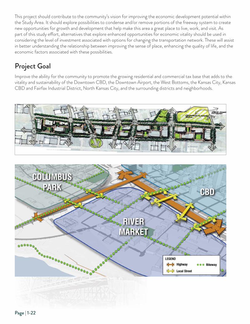
This project should contribute to the community’s vision for improving the economic development potential within the Study Area. It should explore possibilities to condense and/or remove portions of the freeway system to create new opportunities for growth and development that help make this area a great place to live, work, and visit. As part of this study eff ort, alternatives that explore enhanced opportunities for economic vitality should be used in considering the level of investment associated with options for changing the transportation network. These will assist in better understanding the relationship between improving the sense of place, enhancing the quality of life, and the economic factors associated with these possibilities.
Project GoalImprove the ability for the community to promote the growing residential and commercial tax base that adds to the vitality and sustainability of the Downtown CBD, the Downtown Airport, the West Bottoms, the Kansas City, Kansas CBD and Fairfax Industrial District, North Kansas City, and the surrounding districts and neighborhoods.

Page | 1-23
GOAL 2.2 — ENHANCE REGIONAL FREIGHT MOVEMENTSThe transportation of freight by air, barge, rail, and truck is fundamental to the region’s quality of life. Freight systems are how goods produced by area businesses get to market and how consumer goods and business supplies produced elsewhere get to local users. The freight industry supports more than 100,000 jobs in the region. Within the Study Area, facilities for the transport of freight exist for all modes, including air freight at the Downtown Airport, the recently opened multimodal PortKC facility in the West Bottoms, as well as a number of key rail and truck routes. This includes the BNSF railroad over the Missouri River, as well as I-70, I-35, I-29/35 and I-670, which are designated as national freight corridors. In addition, there are a number of key freight hubs within the West Bottoms and the Fairfax Industrial District. Improved access to these regional freight facilities would enhance reliability of existing freight-related businesses, encourag new businesses to locate in the area, and positively impacting the region’s overall economic health.
West BottomsThe West Bottoms is an industrial area immediately west of Downtown at the confl uence of the Missouri and Kansas Rivers. The area is one of the oldest areas of the city and has been home to a number of industries over the years, including the former Kansas City Stockyards and the Darby Steel Corporation. Current industries include PortKC, Wagner Industries, and Faultless Starch/Bon Ami. Freeway access to/from the West Bottoms is limited. The Greater Downtown Area
Plan, adopted in March 2010, recommended a more direct access to the West Bottoms from I-70. In fact, a number of trucks access the West Bottoms by exiting I-29/I-35 at Front Street, traveling west to 3rd Street in the River Market, proceeding west on 3rd Street, and then accessing the West Bottoms via the Woodswether Viaduct.
Fairfax Industrial DistrictThe Fairfax Industrial District (Fairfax) plays a major role in the region’s economy. Fairfax is home to more than 135 businesses, including General Motors, Sunshine Biscuit, Owens Corning, Central Plains Steel, and CertainTeed. These companies manufacture and/or distribute a variety of products throughout the region.
A number of companies located within Fairfax operate large trucks transporting petroleum products, hazardous materials, and heavy loads. They rely on I-70, among other routes, to transport these commodities to their customers. Maintaining and/or improving accessibility to Fairfax is important for maintaining the viability of this important industrial district.

Page | 1-24
Port of KCThe Port of Kansas City occupies approximately 9 acres located at Missouri River mile 367.1 adjacent to the West Bottoms Industrial District. Located near the intermodal yards of fi ve Class I railroads, four interstate highways, and the Kansas City CBD, the Port of Kansas City is the public entity for the reestablishment of waterborne commerce in the Kansas City area. Current terminal capabilities include rail and truck transfer, covered storage, and product distribution. In August 2015, the Port welcomed its fi rst barge since 2007, reasserting the importance of waterway transportation and opening a new era of multimodal transport, with a proposed rail connection expected to be complete in 2017. Like the West Bottoms in general, freeway access to/from this facility is limited and hampers the ability of this facility to transport freight as effi ciently as possible. MARC identifi ed the support of freight on the Missouri River as one of its goods movement strategies in Transportation Outlook 2040.
RailThe Kansas City region is the second largest rail hub in the nation. Within the Study Area, a major intermodal/rail yard known as the BNSF Yard is located immediately east of US-169 north of the Missouri River. Going south out of the BNSF Yard, the only rail crossing of the Missouri River includes the Second Hannibal Bridge immediately east and downstream of the O’Neil Bridge. Coming off the Hannibal Bridge, the railroad tracks make a sharp turn commonly referred to as the “Gooseneck.” This sharp turn results in greatly reduced speeds, adding to delays and operating expenses for rail operations in the area.
Downtown AirportThe Greater Downtown Area Plan, adopted in March 2010, recommended that due to traffi c issues, access to the Downtown Airport should be improved to better accommodate both private passenger and commercial cargo fl ights. The 2004 CBW Land Use
Plan identifi ed options to increase land leases and to focus on new development opportunities at the airport. The plan also recommended promotion of the Downtown Airport as an economic engine and transportation hub, as well as strengthening interstate connections.
Project GoalImprove accessibility to the West Bottoms and Fairfax Industrial Districts, as well as access to PortKC, the Downtown Airport and the BNSF Yard.

Page | 1-25
GOAL 2.3 — PROMOTE QUALITY PLACESThis study off ers an opportunity to further explore the relationship between anticipated transportation investments and economic development opportunities within the Study Area. The results of this project will promote vibrant, enduring, and adaptable places that add to the area’s unique sense of place, while also supporting a high quality of life for residents and visitors alike. These attributes include both public- and private-sector improvements that shape the urban environment within the Study Area.
Urban DesignThe areas, districts, and neighborhoods located within this Study Area vary greatly — ranging from vibrant mixed-use areas within Downtown Kansas City’s CBD, to residential and community-oriented mixed-use destinations in the River Market District and Columbus Park Neighborhood, to more diverse commercial and industrial properties located in the West Bottoms, North Kansas City, and Fairfax Industrial District areas.
Visual Character and AestheticsAs the collection of urban buildings and public spaces within the Study Area continues to improve, the visual character and aesthetic quality of these areas and districts also continues to evolve and contribute to the overall quality of life. The design and appearance of public streets and open spaces play an important role in connecting disparate properties in urban settings, and in many ways help defi ne and promote the unique character and charm found within each of these neighborhoods and districts. This project will also contribute to the overall sense of quality and visual character for these unique districts within the Study Area.
The use of art as part of major public improvement projects has long been a hallmark of promoting quality places within Kansas City, and there are numerous examples of these improvements found throughout the Study Area. Numerous architectural styles are found throughout the Study Area, yet with most older civic buildings there has been a tradition of art deco-inspired style and visual character, which includes the gateway markers leading into downtown at 5th and Broadway. The existing O’Neil Bridge, the Heart of America Bridge, and the recently constructed Bond Bridge also include aesthetic lighting to highlight these unique bridge structures, which celebrate the city’s relationship with the Missouri River environment and Downtown’s connection with the Northland.
Project GoalPromote a strengthened urban environment that allows growth to continue to meet market demands, while supporting a positive sense of place that continues to evolve.

Page | 1-26
Project Goal #3: IMPROVE SUSTAINABILITY GOAL 3.1 — PROMOTE SOCIAL EQUITY & NEIGHBORHOOD REVITALIZATIONThe original construction of urban interstates had the impact of breaking apart low-income and minority communities. This was particularly prevalent in urban cores around the country. Even where impacts on homes and businesses were not direct, the barriers created by this type of infrastructure precluded growth, cut off pedestrian and transit access to jobs, and often caused decline in once thriving neighborhoods. Air and noise pollution have also been areas of concern for communities surrounded by transportation infrastructure. In Kansas City, the Downtown Loop has had a similar impact on the neighboring community.
With the boom in people moving back downtown, transportation’s impact on residential properties, especially low-income and minority neighborhoods, is increasingly important. This includes not only roads, highways and bridges, but also public transportation, bike lanes and paths, and pedestrian walkways. Providing access and eliminating barriers are important considerations in the continued growth and resurgence of Kansas City’s core neighborhoods.
DowntownAt the end of the 19th century, the CBD began to fl ourish around 9th Street with the construction of the New England and New York Life buildings. At the time, Kansas City had the third largest cable car system in the country and was the national center for manufacturing and shipping, livestock sales, and transportation. The work of George Kessler on Kansas City’s parks and boulevard system largely ignored the CBD, leaving the area lacking for green space. Eff orts to build on the strengths of the CBD in the mid-20th century were overshadowed by strict traffi c ordinances that fractured most of downtown, the development of the interstate highway loop, and the creation of a great number of surface parking lots through the elimination of blighted buildings.
Downtown Kansas City, Missouri, experienced decline for some time, with empty commercial space and the loss of retail and restaurants. With the opening of the Sprint Center and the Power & Light District in 2007, Kansas City’s Downtown began to experience renewed energy. Over the last decade there has been a great deal of historic rehabilitation, including many offi ce space conversions to residential units. There have also been a number of new residential projects in Downtown and in the River Market. The population in these areas continues to grow as residential options are added Downtown. The addition of the streetcar line from Union Station to the River Market continues to encourage economic development within this corridor. However, the issues created by the interstate loop and lack of green space continue to be a source of both challenges and opportunities for the CBD.
River MarketThe River Market is a riverfront neighborhood that comprises one of the fi rst and oldest incorporated districts in Kansas City, Missouri. The River Market has also been known as Westport Landing, the City Market, and River Quay. The River Market is situated between I-70 and the Missouri River and is bordered by the O’Neil and Heart of America Bridges. The River Market gets its name from the large open-air farmer’s market. The neighborhood has also seen a resurgence with warehouses increasingly developed into residential developments, restaurants, and markets. The River Market has similar barriers to other neighborhoods in the area with interstate and highway barriers to the CBD and Columbus Park. The addition of the streetcar line has helped to reconnect this neighborhood to the CBD.

Page | 1-27
Columbus ParkThe Columbus Park Neighborhood, which is located between I-29/35 and M-9, was an early home to many immigrants. The neighborhood was sometimes referred to as “Little Italy,” but included immigrant communities from other countries as well. Minority populations began to grow in this area in the late 18th and early 19th centuries. The Garrison Field House, later the Garrison Community Center, was the only settlement center in Kansas City exclusively for African Americans. In the 1950s, the federal government purchased much of the northeast corner of the neighborhood for a public housing development. The neighborhood’s ethnicity began to change with increasing numbers of Hispanics and Southeast Asians. Today, Columbus Park continues to be a vibrant, diverse neighborhood.
Columbus Park is surrounded by highway barriers and the Missouri River. The neighborhood has fared better than many others, but it is missing good connections to downtown and the River Market area. Parking is also an issue in the neighborhood for those coming to visit the ethnically diverse restaurants and businesses.
Strawberry HillThe Strawberry Hill Neighborhood is located on the west side of the Study Area, just south of Downtown Kansas City, Kansas, overlooking the confl uence of the Kansas and Missouri Rivers. The neighborhood was established in the late 19th century as immigrants from Croatia, Slovenia, Serbia, and Russia settled in the area. Existing I-70 on its eastern boundary has historically provided a physical barrier from the neighborhood to the Kansas River, the West Bottoms, and other amenities to the east.
HarlemThe Harlem Neighborhood is located on the north side of the Missouri River between the O’Neil Bridge and the ASB Bridge. In the 1800s and into the early 1900s, this was a town of 50 acres with nearly 600 residents. In 1950 the area was annexed by Kansas City, Missouri. Currently there are only three homes and one apartment complex. When the ASB Bridge opened in 1911, people began bypassing Harlem. The river bridges created barriers, and fl ooding contributed to residents moving out of the area. Over the years, a number of plans for development and redevelopment have been proposed, but none have come to fruition.
Project GoalPromote alternative strategies that reconnect neighborhoods near the Downtown, provide needed revitalization, and promote social equity of the citizens who live and work in these neighborhoods.
The construction of the Downtown Loop in the 1950s
created a physical division between established
neighborhoods resulting in a gradual decay in their
cohesiveness, property values, and quality of life.

Page | 1-28
GOAL 3.2 — MINIMIZE IMPACTS TO HISTORICAL RESOURCESThe Kansas City area has a rich, centuries-old history that dates back to Native American encampments near the confl uence of the Kansas and Missouri Rivers and the work of the well known French fur trader, Francois Chouteau. While there is not much evidence of that era remaining today, the Study Area contains a number of historic landmarks and districts dating back as far as the 1800s.
In the Study Area, there are more than 100 single sites and districts listed in the National Register of Historic Places. These assets include commercial, industrial, and archaeological sites; parks and boulevards; and transportation-related resources in Downtown neighborhoods, North Kansas City, and Kansas City, Kansas. In addition, there are several historic assets located in the Study Area that are listed in the Kansas City Register of Historic Places.
The National Historic Preservation Act (NHPA) sets forth government policy and procedures regarding “historic properties” — that is, districts, sites, buildings, structures, and objects included in or eligible for the National Register of Historic Places. Section 106 of NHPA requires that federal agencies consider the eff ects of their actions on such properties, following regulations issued by the Advisory Council on Historic Preservation (36 CFR 800).
Historic DistrictsGarment District - The Kansas City Garment District is located in Downtown Kansas City, Missouri, to the east of Quality Hill, and across Broadway Boulevard. In the 1930s, several large clothing manufacturers clustered here, making Kansas City’s garment district second only to New York City’s in size. Today, this heritage is commemorated by an oversized needle and thread monument. Its old industrial buildings have since been redeveloped into loft apartments, offi ces, and restaurants. Henry Perry, father of Kansas City-style barbecue, got his start in 1908 from a stand in an alley in the neighborhood.
• River Market — River Market stretches north of the Downtown Loop to the Missouri River, and is bordered by the O’Neil Bridge on the west and the Heart of America Bridge on the east. The area encompasses the location in which Kansas City was fi rst founded. The market name comes from its large open-air farmers’ market, the southern section of which was the public square in the mid-19th century.
• West Bottoms — The West Bottoms is an industrial area immediately to the west of Downtown Kansas City, Missouri, at the confl uence of the Missouri River and the Kansas River. The area is one of the oldest areas of the city, with a large industrial base, and has been undergoing recent redevelopment.
• Strawberry Hill — Strawberry Hill is a Kansas City, Kansas, neighborhood on the bluff s overlooking the confl uence of the Kansas and Missouri Rivers. Strawberry Hill was previously known as Splitlog Hill, after Mathias Splitlog, a wealthy Indian mill owner who purchased the area and built a mansion on it in 1870. After the area was subdivided, the new Strawberry Hill neighborhood was established in the late 19th century. Immigrants from Croatia, Slovenia, Serbia, and Russia found a home along the river’s hillside. They built a community where people could worship, celebrate, and prosper while maintaining their distinct Slavic heritage.
Project GoalProtect existing historical resources and promote strategies that preserve the historical context that exists in the Study Area.

Page | 1-29
GOAL 3.3 — MINIMIZE IMPACTS TO NATURAL ENVIRONMENTAL RESOURCESThe project Study Area has changed dramatically over the last 150 years, and most of the original natural environmental resources have been disturbed through the ongoing urbanization of the area. However, the remaining natural resources need to be protected as the project identifi es and evaluates the various improvement strategies.
Environmental ResourcesImprovement recommendations need to include an evaluation of their respective impacts on the following environmental resources.
• Floodway and Floodplains — Floodplains are the low lands adjoining the channel of a river, stream, or watercourse or other water body that have been or may be inundated with fl ood water. There are two regulated fl oodplain locations in the West Bottoms District, one in the Historic Harlem Neighborhood, and one in Berkley Riverfront Park. The fl oodway, in contrast, is the area of a stream or river channel that must be kept open to convey fl oodwaters. There are designated fl oodways on both sides of the Missouri and Kansas Rivers within the Study Area.
• Water Quality — Water quality is defi ned for a particular water body based on its biological, chemical, and physical characteristics in accordance with a set of standards. Water quality standards were put in place to fortify bodies of water that would benefi t from continuous usage by humans, aquatic life, livestock, and wildlife. Surface waters in the Study Area with water quality issues include the Missouri River and the Kansas River.
• Stormwater — Improving infrastructure without proper design measures can lead to increased fl ooding during storm events. From a water quality standpoint, stormwater may transport contaminants and other detrimental items to natural waterways. In addition, Kansas City is served by combined sewers that carry both stormwater and sanitary wastewater, which during storm events can lead to overfl ows that impact the water quality of natural waterways. The city is under a consent decree from the U.S. Environmental Protection Agency to reduce its overfl ows or face large fi nes.
• Wetland Habitat — A wetland is an area that is either permanently or seasonally saturated with water and, thereby, creates its own distinct ecosystem. The majority of wetlands identifi ed within the Study Area are riverine wetlands, mostly occurring in a narrow fringe along the Missouri and Kansas Rivers.
• Hazardous Materials Sites - Sites that are contaminated, or potentially contaminated with hazardous materials or waste, were identifi ed within the Study Area. In all, 23 sites were identifi ed as having a high potential impact and would require extensive time and cost to assess and remediate if disturbed by the proposed improvement. Additional evaluation and assessment of each impacted site, if any, would identify the presence/absence, nature, and extent of contamination, as well as potential avoidance options.
• Threatened and Endangered Species — Vegetative communities and wildlife are not abundant but do exist and potential habitat has been identifi ed for 24 federally and/or state protected species within the Study Area.
• Parks and Recreational Resources — Recreational resources are federally protected community facilities that include parks, trails, and open space that off er opportunities for recreation. There are 15 parks within or immediately adjacent to the Study Area.
• Energy Conservation — In line with the region, the country and the world, emphasis on sustainable transportation projects should identify opportunities to conserve energy and promote solutions that reuse and/or recycle existing materials.
• Noise — Noise is an important factor in the quality of life for surrounding noise receptors and those that may be especially sensitive to noise, including schools, parks, residences, churches, cemeteries, and libraries.

Page | 1-30
• Air Quality — Air quality considerations are important for protecting the public health, safety, and welfare from specifi ed pollutants, including greenhouse gas emissions. The Kansas City metropolitan area currently meets the federal requirements for “attainment,” but does experience 10 to 15 days each year where the quality of the air oes not meet those standards.
Project GoalProtect existing natural resources and promote strategies that improve the sustainability of the transportation network and areas aff ected by the proposed improvements in the Study Area.
The evaluation of proposed improvement strategies
needs to identify opportunities to avoid, minimize, and
if unavoidable, mitigate negative impacts to the natural
environment. Detailed discussion of each of the environ-
mental factors has been provided in Chapter 3 - Environ-
mental Conditions.
Page | 1-31
GOAL 3.4 — INTEGRATE NEW TRANSPORTATION TECHNOLOGIESThe advent of autonomous and connected vehicles (AV/CVs), or driverless vehicles, is a closely watched technological development. This development has the potential to bring a paradigm shift in the transportation sector that impacts the everyday lives of countless people. AV/CVs are programmed vehicles that operate in pre-mapped driving areas, navigating between fi xed and moving obstacles. With the use of a variety of sensors attached externally, AV/CVs are able to make algorithmic decisions based on data received and processed from sensors within seconds. AV/CVs can also be connected vehicles communicating with other AV/CVs to optimize traffi c fl ow for the desired travelway speed. In theory, AV/CV technology should signifi cantly increase the effi ciency of our existing transportation network to the point that traffi c queues, delays, and accidents would approach zero. This new technology is already being tested in autonomous fl eets, in transit with passenger shuttles, and in freight with last-mile aerial delivery and freight shuttles.
Autonomous FleetsAV/CVs are central to developing on-demand mobility fl eets. Sharing rides will have the eff ect of reducing congestion, transforming the livability of cities, and allowing people to travel quickly and safely. AV/CVs will off er mobility to those who cannot drive, and in conjunction with car-sharing, can off er mobility to those who do not have ready access to a car. For riders who could normally drive themselves, AV/CVs can off er amenities similar to those of transit in terms of being able to read, sleep, or work. Accommodating self-driving vehicles will require cities to rethink their infrastructure to include the potential for special dedicated lanes or geo-fenced areas.
Autonomous TransitAV/CV passenger shuttles are being developed and tested to run fi xed-routes stopping at designated stops. Designed to travel short distances, these shuttles would ideally serve fi rst, and last-mile trips. Collision Avoidance Systems (CAS) have already been developed for cars, with options that include adaptive cruise control, blind spot detection, and lane departure warning. Although bus transit is one of the safest ways to travel, these options could reduce the frequency and severity of collisions and reduce associated liability expenses. Precision docking technology is also being used in Oregon for bus rapid transit (BRT) vehicles. These are classifi ed as driver-assist systems, which are not technically related to automation.
Freight DeliveriesTruck trains or caravans would reduce the cost of fuel and haul more freight per trip. The lead truck would have one driver in the cab who would lead the caravan of a dozen or so trucks along the highway. Platooning technology connects two or more trucks via cloud technology and uses safety features like active braking. The lead truck driver would control all the trucks, but drivers would still be needed to maneuver the highway exits, city streets, and backing up to the loading dock. Semi-autonomous freight trucks might also help to address the current driver shortage. Several freight companies, including UPS and Amazon, as well as manufacturers like Ford, are also looking at supplementing their normal ground delivery services with last-mile aerial drone delivery to increase the effi ciency of deliveries while understanding the power limitations of aerial delivery vehicles.
Project GoalIdentify how the AV/CV technology will be incorporated in the Study Area and make recommendations on its inclusion, integration, or exclusion. Any improvements identifi ed need to take into account the transformation being brought on by this new technology and incorporate improvements that will aid in its implementation.
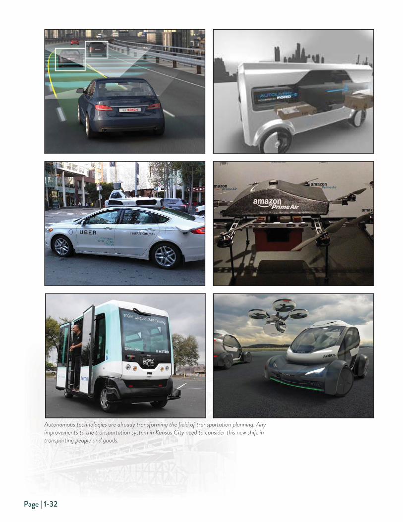
Page | 1-32
Autonomous technologies are already transforming the fi eld of transportation planning. Any
improvements to the transportation system in Kansas City need to consider this new shift in
transporting people and goods.


