![Index []€¦ · the unit theme. Pushes pupils’ knowledge further and provides HOTS activities. Helps pupils activate existing knowledge. Presents the core curricular content and](https://static.fdocuments.net/doc/165x107/603f8035241dac07bc0b9943/index-the-unit-theme-pushes-pupilsa-knowledge-further-and-provides-hots-activities.jpg)
Pupils should extend their knowledge and ...
12
Purpose of Study: At St Joseph’s we believe a high-quality geography education should inspire in pupils a curiosity and fascination about the world and its people that will remain with them for the rest of their lives. Teaching should equip pupils with knowledge about diverse places, people, resources and natural and human environments, together with a deep understanding of the Earth’s key physical and human processes. As pupils progress, their growing knowledge about the world should help them to deepen their understanding of the interaction between physical and human processes, and of the formation and use of landscapes and environments. Geographical knowledge, understanding and skills provide the frameworks and approaches that explain how the Earth’s features at different scales are shaped, interconnected and change over time. Geography in EYFS: Three and Four-Year-Olds Mathematics • Understand position through words alone. For example, “The bag is under the table,” – with no pointing. • Describe a familiar route. • Discuss routes and locations, using words like ‘in front of’ and ‘behind’. Understanding the World • Use all their senses in hands-on exploration of natural materials. • Begin to understand the need to respect and care for the natural environment and all living things. • Know that there are different countries in the work and talk about the differences they have experienced or seen in photos. Reception Understanding the World • Draw information from a simple map. • Recognise some similarities and differences between life in this country and life in other countries. • Explore the natural world around them. • Recognise some environments that are different to the one in which they live. ELG Understanding the World People, Culture and Communities • Describe their immediate environment using knowledge from observation, discussion, stories, non-fiction texts and maps. • Explain some similarities and differences between life in this country and life in other countries, drawing on knowledge from stories, non-fiction texts and (when appropriate) maps. The Natural World • Know some similarities and differences between the natural world around them and contrasting environments, drawing on their experiences and what has been read in class. • Understand some important processes and changes in the natural world around them, including the seasons. National Curriculum Aims (Progression Map): KS1 LKS2 UKS2 Locational Knowledge Pupils develop contextual knowledge of the location of globally significant places. They should develop knowledge about the world, the United Kingdom and their locality. Pupils can: a) name and locate the world’s seven continents and five oceans; b) name, locate and identify characteristics of the four countries and capital cities of the United Kingdom and its surrounding seas; c) use key vocabulary to demonstrate knowledge and understanding in this strand: United Kingdom, England, Scotland, Wales, Northern Ireland, town, city, village, sea, beach, hill, mountain, London, Belfast, Cardiff, Edinburgh, capital city, world map, continent, ocean, Europe, Africa, Asia, Australasia, North America, South America, Antarctica. Pupils should extend their knowledge and understanding beyond the local area to include the United Kingdom and Europe, North and South America. Children can develop contextual knowledge of the location of globally significant places – both terrestrial and marine. Children develop their understanding, recognising and identifying key physical and human geographical features. Pupils can: a) locate the world’s countries, using maps to focus on South America, concentrating on environmental regions and key physical and human characteristics; b) name and locate counties and cities of the United Kingdom, identifying human and physical characteristics including hills, mountains, rivers and seas, and how a place has changed; c) identify the position and significance of latitude, longitude, Equator, Northern Hemisphere, Southern Hemisphere, the Tropics of Cancer and Capricorn, Arctic and Antarctic Circle, the Prime/Greenwich Meridian and time zones; d) use key vocabulary to demonstrate knowledge and understanding in this strand: county, country, town, coast, physical features, human features, mountain, hill, river, sea, Pupils should extend their knowledge and understanding beyond the local area to include the United Kingdom and Europe, North and South America. They will begin to explore the concept of tourism and its impact. Children can develop contextual knowledge of the location of globally significant places – both terrestrial and marine. Children develop their understanding of recognising and identifying key physical and human geographical features of the world; how these are interdependent and how they bring about spatial variation and change over time. Pupils can: a) use maps to locate the world’s countries with a focus on Eastern Europe and South America, concentrating on their environmental regions, key physical and human characteristics, countries, and major cities; b) name and locate counties and cities of the United Kingdom, identifying their physical features, including mountains, and rivers, and land-use patterns; showing change over time; c) identify the position and significance of latitude, longitude, Equator, Northern Hemisphere, Southern Hemisphere and use longitude and latitude to find locations on a map; d) use key vocabulary to demonstrate knowledge and understanding in this strand: atlas, index, coordinates, latitude, longitude, contour, altitude, peaks, slopes, continent, country, city, North America, South America, border, key.
Transcript of Pupils should extend their knowledge and ...

Purpose of Study: At St Joseph’s we believe a high-quality geography education should inspire in pupils a curiosity and fascination about the world and its people that will remain with them for the rest of their lives. Teaching should equip pupils with knowledge about diverse places, people, resources and natural and human environments, together with a deep understanding of the Earth’s key physical and human processes. As pupils progress, their growing knowledge about the world should help them to deepen their understanding of the interaction between physical and human processes, and of the formation and use of landscapes and environments. Geographical knowledge, understanding and skills provide the frameworks and approaches that explain how the Earth’s features at different scales are shaped, interconnected and change over time. Geography in EYFS:
Three and Four-Year-Olds
Mathematics • Understand position through words alone. For example, “The bag is under the table,” – with no pointing. • Describe a familiar route. • Discuss routes and locations, using words like ‘in front of’ and ‘behind’.
Understanding the World • Use all their senses in hands-on exploration of natural materials. • Begin to understand the need to respect and care for the natural environment and all living things. • Know that there are different countries in the work and talk about the differences they have experienced or seen in photos.
Reception Understanding the World
• Draw information from a simple map. • Recognise some similarities and differences between life in this country and life in other countries. • Explore the natural world around them. • Recognise some environments that are different to the one in which they live.
ELG Understanding the
World
People, Culture and Communities
• Describe their immediate environment using knowledge from observation, discussion, stories, non-fiction texts and maps. • Explain some similarities and differences between life in this country and life in other countries, drawing on knowledge from stories, non-fiction texts and
(when appropriate) maps.
The Natural World • Know some similarities and differences between the natural world around them and contrasting environments, drawing on their experiences and what has
been read in class. • Understand some important processes and changes in the natural world around them, including the seasons.
National Curriculum Aims (Progression Map):
KS1 LKS2 UKS2
Locational
Knowledge
Pupils develop contextual knowledge of the location of globally significant places. They should develop knowledge about the world, the United Kingdom and their locality. Pupils can:
a) name and locate the world’s seven continents and five oceans;
b) name, locate and identify characteristics of the four countries and capital cities of the United Kingdom and its surrounding seas;
c) use key vocabulary to demonstrate knowledge and understanding in this strand: United Kingdom, England, Scotland, Wales, Northern Ireland, town, city, village, sea, beach, hill, mountain, London, Belfast, Cardiff, Edinburgh, capital city, world map, continent, ocean, Europe, Africa, Asia, Australasia, North America, South America, Antarctica.
Pupils should extend their knowledge and understanding beyond the local area to include the United Kingdom and Europe, North and South America. Children can develop contextual knowledge of the location of globally significant places – both terrestrial and marine. Children develop their understanding, recognising and identifying key physical and human geographical features. Pupils can:
a) locate the world’s countries, using maps to focus on South America, concentrating on environmental regions and key physical and human characteristics;
b) name and locate counties and cities of the United Kingdom, identifying human and physical characteristics including hills, mountains, rivers and seas, and how a place has changed;
c) identify the position and significance of latitude, longitude, Equator, Northern Hemisphere, Southern Hemisphere, the Tropics of Cancer and Capricorn, Arctic and Antarctic Circle, the Prime/Greenwich Meridian and time zones;
d) use key vocabulary to demonstrate knowledge and understanding in this strand: county, country, town, coast, physical features, human features, mountain, hill, river, sea,
Pupils should extend their knowledge and understanding beyond the local area to include the United Kingdom and Europe, North and South America. They will begin to explore the concept of tourism and its impact. Children can develop contextual knowledge of the location of globally significant places – both terrestrial and marine. Children develop their understanding of recognising and identifying key physical and human geographical features of the world; how these are interdependent and how they bring about spatial variation and change over time. Pupils can:
a) use maps to locate the world’s countries with a focus on Eastern Europe and South America, concentrating on their environmental regions, key physical and human characteristics, countries, and major cities;
b) name and locate counties and cities of the United Kingdom, identifying their physical features, including mountains, and rivers, and land-use patterns; showing change over time;
c) identify the position and significance of latitude, longitude, Equator, Northern Hemisphere, Southern Hemisphere and use longitude and latitude to find locations on a map;
d) use key vocabulary to demonstrate knowledge and understanding in this strand: atlas, index, coordinates, latitude, longitude, contour, altitude, peaks, slopes, continent, country, city, North America, South America, border, key.
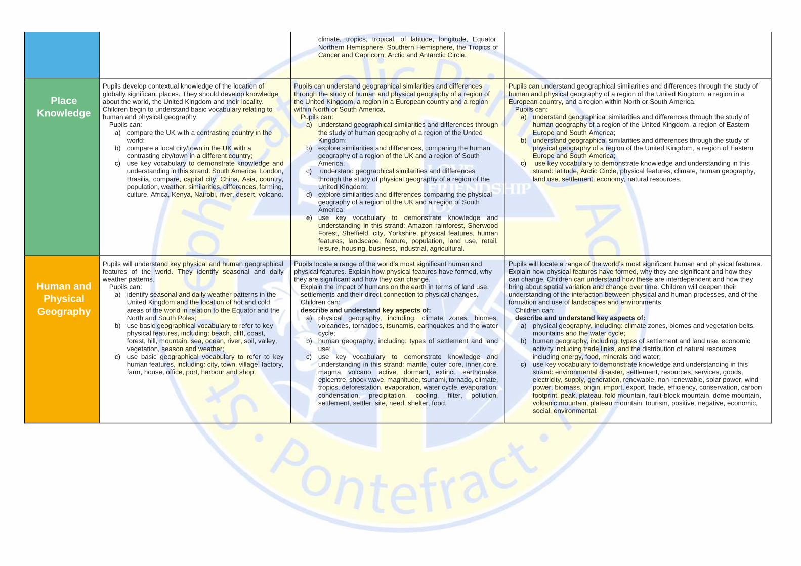
climate, tropics, tropical, of latitude, longitude, Equator, Northern Hemisphere, Southern Hemisphere, the Tropics of Cancer and Capricorn, Arctic and Antarctic Circle.
Place
Knowledge
Pupils develop contextual knowledge of the location of globally significant places. They should develop knowledge about the world, the United Kingdom and their locality. Children begin to understand basic vocabulary relating to human and physical geography.
Pupils can: a) compare the UK with a contrasting country in the
world; b) compare a local city/town in the UK with a
contrasting city/town in a different country; c) use key vocabulary to demonstrate knowledge and
understanding in this strand: South America, London, Brasilia, compare, capital city, China, Asia, country, population, weather, similarities, differences, farming, culture, Africa, Kenya, Nairobi, river, desert, volcano.
Pupils can understand geographical similarities and differences through the study of human and physical geography of a region of the United Kingdom, a region in a European country and a region within North or South America.
Pupils can: a) understand geographical similarities and differences through
the study of human geography of a region of the United Kingdom;
b) explore similarities and differences, comparing the human geography of a region of the UK and a region of South America;
c) understand geographical similarities and differences through the study of physical geography of a region of the United Kingdom;
d) explore similarities and differences comparing the physical geography of a region of the UK and a region of South America;
e) use key vocabulary to demonstrate knowledge and understanding in this strand: Amazon rainforest, Sherwood Forest, Sheffield, city, Yorkshire, physical features, human features, landscape, feature, population, land use, retail, leisure, housing, business, industrial, agricultural.
Pupils can understand geographical similarities and differences through the study of human and physical geography of a region of the United Kingdom, a region in a European country, and a region within North or South America.
Pupils can: a) understand geographical similarities and differences through the study of
human geography of a region of the United Kingdom, a region of Eastern Europe and South America;
b) understand geographical similarities and differences through the study of physical geography of a region of the United Kingdom, a region of Eastern Europe and South America;
c) use key vocabulary to demonstrate knowledge and understanding in this strand: latitude, Arctic Circle, physical features, climate, human geography, land use, settlement, economy, natural resources.
Human and
Physical
Geography
Pupils will understand key physical and human geographical features of the world. They identify seasonal and daily weather patterns.
Pupils can: a) identify seasonal and daily weather patterns in the
United Kingdom and the location of hot and cold areas of the world in relation to the Equator and the North and South Poles;
b) use basic geographical vocabulary to refer to key physical features, including: beach, cliff, coast, forest, hill, mountain, sea, ocean, river, soil, valley, vegetation, season and weather;
c) use basic geographical vocabulary to refer to key human features, including: city, town, village, factory, farm, house, office, port, harbour and shop.
Pupils locate a range of the world’s most significant human and physical features. Explain how physical features have formed, why they are significant and how they can change.
Explain the impact of humans on the earth in terms of land use, settlements and their direct connection to physical changes. Children can: describe and understand key aspects of:
a) physical geography, including: climate zones, biomes, volcanoes, tornadoes, tsunamis, earthquakes and the water cycle;
b) human geography, including: types of settlement and land use;
c) use key vocabulary to demonstrate knowledge and understanding in this strand: mantle, outer core, inner core, magma, volcano, active, dormant, extinct, earthquake, epicentre, shock wave, magnitude, tsunami, tornado, climate, tropics, deforestation, evaporation, water cycle, evaporation, condensation, precipitation, cooling, filter, pollution, settlement, settler, site, need, shelter, food.
Pupils will locate a range of the world’s most significant human and physical features. Explain how physical features have formed, why they are significant and how they can change. Children can understand how these are interdependent and how they bring about spatial variation and change over time. Children will deepen their understanding of the interaction between physical and human processes, and of the formation and use of landscapes and environments.
Children can: describe and understand key aspects of:
a) physical geography, including: climate zones, biomes and vegetation belts, mountains and the water cycle;
b) human geography, including: types of settlement and land use, economic activity including trade links, and the distribution of natural resources including energy, food, minerals and water;
c) use key vocabulary to demonstrate knowledge and understanding in this strand: environmental disaster, settlement, resources, services, goods, electricity, supply, generation, renewable, non-renewable, solar power, wind power, biomass, origin, import, export, trade, efficiency, conservation, carbon footprint, peak, plateau, fold mountain, fault-block mountain, dome mountain, volcanic mountain, plateau mountain, tourism, positive, negative, economic, social, environmental.

Geographica
l Skills and
Fieldwork
Children can interpret geographical information from a range of sources. They can communicate geographical information in a variety of ways.
Children can: a) use world maps, atlases and globes to identify the
countries, continents and oceans studied at this key stage;
b) use simple compass directions and locational and directional to describe the location of features and routes on a map;
c) devise a simple map; and use and construct basic symbols in a key;
d) use simple fieldwork and observational skills to study the geography of the surrounding area, including key human and physical features, using a range of methods;
e) use key vocabulary to demonstrate knowledge and understanding in this strand: compass, 4-point, direction, North, East, South, West, plan, record, observe, aerial view, key, map, symbols, direction, position, route, journey, the UK, changes, tally chart, pictogram, world map, country, continent, human, physical.
Children collect, analyse and communicate a range of data gathered through fieldwork that deepens their understanding of geographical processes. They interpret a range of sources of geographical information including maps, diagrams, globes, aerial photographs and Geographical Information Systems (GIS).
Children can: a) use maps, atlases, globes and digital/computer mapping to
locate countries and describe features studied; b) use symbols and keys (including the use of Ordnance
Survey maps), to build their knowledge of the United Kingdom and the wider world;
c) use fieldwork to observe and present the human and physical features in the local area using sketch maps, plans and digital technologies;
d) use key vocabulary to demonstrate knowledge and understanding in this strand: sketch map, map, aerial view, feature, annotation, landmark, distance, key, symbol, land use, urban, rural, population, coordinates.
Children will become confident in collecting, analysing, and communicating a range of data. Children can explain how the Earth’s features at different scales are shaped, interconnected and change over time.
Children can: a) use maps, atlases, globes and digital/computer mapping to locate countries
and describe features; b) use the eight points of a compass, four and six-figure grid references,
symbols and key (including the use of Ordnance Survey maps) to build their knowledge of the United Kingdom and the wider world;
c) use fieldwork to observe, measure, record and present human features using a range of methods, including sketch maps, plans and graphs, and digital technologies;
d) use key vocabulary to demonstrate knowledge and understanding in this strand: atlas, index, coordinates, latitude, longitude, key, symbol, Ordnance Survey, Silva compass, legend, borders, fieldwork, measure, observe, record, map, sketch, graph.
National Curriculum Subject Content:
Key Stage 1 National Curriculum Expectations Key Stage 2 National Curriculum Expectations
Locational Knowledge Pupils should be taught to:
● name and locate the world’s seven continents and five oceans; ● name, locate and identify characteristics of the four countries and capital cities of the United Kingdom and its surrounding seas.
Place Knowledge Pupils should be taught to:
● understand geographical similarities and differences through studying the human and physical geography of a small area of the United Kingdom, and of a small area in a contrasting non-European country.
Human and Physical Geography Pupils should be taught to:
● identify seasonal and daily weather patterns in the United Kingdom and the location of hot and cold areas of the world in relation to the Equator and the North and South Poles;
● use basic geographical vocabulary to refer to: - key physical features, including: beach, cliff, coast, forest, hill, mountain, sea, ocean, river, soil, valley, vegetation, season and weather; - key human features, including: city, town, village, factory, farm, house, office, port, harbour and shop.
Geographical Skills and Fieldwork Pupils should be taught to: ● use world maps, atlases and globes to identify the United Kingdom and its countries, as well as the countries, continents and
oceans studied at this key stage; ● use simple compass directions (North, South, East and West) and locational and directional language [for example, near and far;
left and right], to describe the location of features and routes on a map; ● use aerial photographs and plan perspectives to recognise landmarks and basic human and physical features; devise a simple
map; and use and construct basic symbols in a key; ● use simple fieldwork and observational skills to study the geography of their school and its grounds and the key human and
physical features of its surrounding environment.
Locational Knowledge Pupils should be taught to:
● locate the world’s countries, using maps to focus on Europe (including the location of Russia) and North and South America, concentrating on their environmental regions, key physical and human characteristics, countries, and major cities;
● name and locate counties and cities of the United Kingdom, geographical regions and their identifying human and physical characteristics, key topographical features (including hills, mountains, coasts and rivers), and land-use patterns; and understand how some of these aspects have changed over time;
● identify the position and significance of latitude, longitude, Equator, Northern Hemisphere, Southern Hemisphere, the Tropics of Cancer and Capricorn, Arctic and Antarctic Circle, the Prime/Greenwich Meridian and time zones (including day and night).
Place Knowledge Pupils should be taught to:
● understand geographical similarities and differences through the study of human and physical geography of a region of the United Kingdom, a region in a European country, and a region within North or South America
Human and Physical Geography Pupils should be taught to: ● describe and understand key aspects of:
- physical geography, including: climate zones, biomes and vegetation belts, rivers, mountains, volcanoes and earthquakes, and the water cycle; - human geography, including: types of settlement and land use, economic activity including trade links, and the distribution of natural resources including energy, food, minerals and water.
Geographical Skills and Fieldwork Pupils should be taught to: ● use maps, atlases, globes and digital/computer mapping to locate countries and describe features studied; ● use the eight points of a compass, four and six-figure grid references, symbols and key (including the use of Ordnance
Survey maps) to build their knowledge of the United Kingdom and the wider world; ● use fieldwork to observe, measure, record and present the human and physical features in the local area using a range
of methods, including sketch maps, plans and graphs, and digital technologies.

In Key Stage 1, pupils will study:
Topic Year 1 Year 2
Where Do I Live? Around the World The Four Seasons At the Farm Let’s go on Safari My World and Me
Overview The children will find out more about the town, country and continent they live in with this great Our Local Area KS1 scheme of work. Our children will find out where the United Kingdom is located on a world map and explore the features of the countries and capital cities of the UK, before finding out more about their local area.
Our Year 1 children will be taken on a whistle-stop tour around the world with this seven continents of the world KS1 Geography planning pack. Join Buddy the Bee as he visits a country on each of the seven continents and explores their features, people and landmarks. The class will learn where the seven continents are on a map and undertake a variety of fun activities to help them learn more about each one.
Year 1 will learn about the weather patterns of the seasons with this Four Seasons Geography unit. Through these seasons lessons, your class will find out which months of the year belong to which season, as well as what the weather is like in Spring, Summer, Autumn and Winter, and what this means for animals, people and the landscape.
Year 2 will take a trip to the countryside and explore a working farm in this fun unit of work. The children will find out about arable, livestock and dairy farms and the difference between them, before taking a closer look at a fictional farm that does a little of everything! The class will learn about the features of a farm and use a map to navigate around a farm, as well as thinking about the differences between life in the country and life in a busy town.
Year 2 will go on safari to Africa with this Kenya KS1 Geography unit of work. They will join explorers as they visit Kenya and meet the people, wildlife and landscapes. The class will learn where Kenya is on a map and develop an understanding of Kenya as a hot country and how this effects compare it to the UK.
The children in Year 2 will learn where the seven continents of the world are and how their proximity to the equator or the poles affects their climate with this. The class will study different countries and explore their climate and land features. They will undertake a variety of fun activities to help them learn more about each one.
Pupils – (Key Knowledge):
-know that the world is split into seven land masses called continents. -know that there are oceans between the continents. -know what a settlement is. -know the difference between a continent and a country. -know the names of the four countries of the UK. -know and name the four capital cities of the UK and match them to their country. -know where the capital cities of the UK are on a map.
-know that France is a country in Europe. -know that China is a country in Asia. -know that Australia is the name of both a country and a continent. -know that Kenya is a country in Africa. -know that the USA is a country in North America. -know that Brazil is a country in South America. -know that there are no countries in Antarctica. -know that the lines within a map denote country borders. -know that some countries are hot countries and some countries are cold countries Why these countries
-know what seasons are and how they relate to the months of the year.
-know the difference between arable, dairy and livestock farming. -know how the different seasons affect life on a farm and can explain what happens on a farm in the different seasons. -know what the four points of a compass are.
-know that Nairobi is the capital city of Kenya. -know that countries near the equator are hot countries and countries near the poles are cold countries. -know that Kenya is near the equator so it is a hot country. -know that there are lots of different groups of people in Kenya and that some live in traditional tribes and some live in modern cities - examples. Know differences between the the landscapes and settlements of Kenya and the UK.
-know what the physical features of the UK and Ecuador are. -know what the capital cities of the UK and Ecuador are -know of animals that live in hot countries -know of animals that live in cold countries -know the names of the five oceans
Key Skills -can identify and describe some of the physical features of the UK, such as mountains, hills and lakes. -can describe the basic differences between a village, town and city. -can locate the United Kingdom on a world map.
-can identify and describe some key human and physical features of countries in each of the continents. -can use words such as city, beach, mountain and lake to describe features of a place. -can identify the UK and France on a map of
-can describe the features of each of the seasons using appropriate vocabulary to describe weather patterns. -can compare the four seasons.
-can describe how living on a farm is different from living in a town using vocabulary such as buildings, fields, shops and roads. -can use an aerial photo to identify features, such as buildings, fields and roads.
-can describe how the climate is different in Kenya to the UK. -can compare and contrast the landscapes and settlements of Kenya and the UK. -can describe some of the cultural features of Kenya.
-can compare the climate of the UK and Ecuador. -can compare and contrast the physical features of the UK and Ecuador. -can compare and contrast the capital cities of Ecuador and the UK, considering physical and human features.

-can locate the four countries of the UK on a map. -can explore my local area, identifying basic human and physical features. Specific Examples -can explore a map of my local area and identify basic features, such as roads and rivers.
Europe. -can locate the seven continents on a world map.
-can use a map with a simple key to identify features of a farm, such as different buildings and fields. -can use the four compass points to navigate around a map, for example by identifying what is north of the hay barn or east of the chicken shed.
-can describe which oceans surround the continent of Africa. -can navigate around a map using a grid and compass directions. -can describe the physical features of Kenya, using vocabulary such as beach, volcano, mountains, savannah and valley.
-can describe the physical and human features of Ecuador. -can identify animals that live in hot and cold countries. -can locate the five oceans on a map. -can identify the equator and the poles on a world map. -can use aerial photos to describe a variety of landscapes and locations around the world. -can create a map of my route to school using a key.
Key Vocabulary School, countryside, house, near, far, distance, where, observe, compass, direction, plan, United Kingdom, country, capital city, national, map, village, town, city, address, fieldwork
Continent, country, Europe, Asia, Australia, Africa, North America, South America, Antarctica, United States of America, Brazil, Kenya, China, France, locate, identify, map
seasons, Autumn, Winter, Spring, Summer, temperature, thermometer, United Kingdom, affects, weather forecast, symbols, climate
Farm, arable, livestock, agriculture, dairy, rural, urban, recreation, retail, pasture, crops, compass, seasons, counties
Continent, ocean, Kenya, climate, compass, savannah, valley, mountain, beach, city, village, landscape, rural, tribe, lifestyle
continent, ocean, locate, United Kingdom, equator, poles, Ecuador, globe, map, cliff, valley, mountain, river lake
Links with prior learning EYFS – Understanding the world People, Culture and Communities The Natural World
EYFS – Understanding the world. People, Culture and Communities. The Natural World KS1 - Where do I live?
EYFS – Understanding the world. The Natural World
EYFS – Understanding the world KS1 - Where do I live?
EYFS – Understanding the world KS1 - Around the World
EYFS – Understanding the world KS1 - Where do I live? KS1 - Around the world KS1 – Lets go on Safari
Links with future learning
KS1 - Around the World KS1 - Let’s go on Safari KS1 - My World and Me
KS1 - Let’s go on Safari KS1 - My World and Me LKS2 – Our European Neighbours
KS1 - My World and Me LKS2 – Where does our food come from? LKS2 – Countries of the world
LKS2 - Countries of the world
LKS2 – Countries of the world
National Curriculum Links name and locate the world’s seven continents and five oceans name, locate and identify characteristics of the four countries and capital cities of the United Kingdom and its surrounding seas use world maps, atlases and globes to identify the United Kingdom and its countries, as well as the countries, continents and oceans studied at this key stage use simple fieldwork and observational skills to study the geography of their school and its grounds and the key
name and locate the world’s seven continents and five oceans use world maps, atlases and globes to identify the United Kingdom and its countries, as well as the countries, continents and oceans studied at this key stage use basic geographical vocabulary to refer to: key physical features, including: beach, cliff, coast, forest, hill, mountain, sea, ocean, river, soil, valley, vegetation, season and weather
identify seasonal and daily weather patterns in the United Kingdom and the location of hot and cold areas of the world in relation to the Equator and the North and South Poles use basic geographical vocabulary to refer to: key physical features, including: beach, cliff, coast, forest, hill, mountain, sea, ocean, river, soil, valley, vegetation, season and weather
use aerial photographs and plan perspectives to recognise landmarks and basic human and physical features; devise a simple map; and use and construct basic symbols in a key use basic geographical vocabulary to refer to: key human features, including: city, town, village, factory, farm, house, office, port, harbour and shop use simple compass directions (North, South, East and West) and locational and directional language [for example, near and far; left and right], to describe the
understand geographical similarities and differences through studying the human and physical geography of a small area of the United Kingdom, and of a small area in a contrasting non-European country use basic geographical vocabulary to refer to: key physical features, including: beach, cliff, coast, forest, hill, mountain, sea, ocean, river, soil, valley, vegetation, season and weather name and locate the world’s seven continents and five oceans
use aerial photographs and plan perspectives to recognise landmarks and basic human and physical features; devise a simple map; and use and construct basic symbols in a key name and locate the world’s seven continents and five oceans identify seasonal and daily weather patterns in the United Kingdom and the location of hot and cold areas of the world in relation to the Equator and the North and South Poles

human and physical features of its surrounding environment. use basic geographical vocabulary to refer to: key physical features, including: beach, cliff, coast, forest, hill, mountain, sea, ocean, river, soil, valley, vegetation, season and weather use basic geographical vocabulary to refer to: key human features, including: city, town, village, factory, farm, house, office, port, harbour and shop
location of features and routes on a map use basic geographical vocabulary to refer to: key physical features, including: beach, cliff, coast, forest, hill, mountain, sea, ocean, river, soil, valley, vegetation, season and weather
use world maps, atlases and globes to identify the United Kingdom and its countries, as well as the countries, continents and oceans studied at this key stage use simple compass directions (North, South, East and West) and locational and directional language [for example, near and far; left and right], to describe the location of features and routes on a map
understand geographical similarities and differences through studying the human and physical geography of a small area of the United Kingdom, and of a small area in a contrasting non-European country use basic geographical vocabulary to refer to: key physical features, including: beach, cliff, coast, forest, hill, mountain, sea, ocean, river, soil, valley, vegetation, season and weather use basic geographical vocabulary to refer to: key human features, including: city, town, village, factory, farm, house, office, port, harbour and shop use world maps, atlases and globes to identify the United Kingdom and its countries, as well as the countries, continents and oceans studied at this key stage use simple fieldwork and observational skills to study the geography of their school and its grounds and the key human and physical features of its surrounding environment.
In Lower Key Stage 2, pupils will study:
Topic Year 3 Year 4
Countries of the World Where does our food come from?
In the Desert Our European Neighbours Village settlers Earning a Living
Overview Year 3 will learn about the wider world with this fantastic 'Countries of the World' series of lessons. Not only will the class recap on their identification and locat the seven continents and some of the countries within each one, but they will also explore areas of human and physical geography around the world, from population and culture to mountains and rivers.
The children of Year 3 will go on a journey around the world, visiting farms in temperate, tropical, and Mediterranean climates. This unit teaches children about the locational language used to describe locations around the world. They will also learn about the climate conditions in a range of different biomes, how food is produced, traded, and
Grab your water bottles and set off to the driest places on Earth with this 'In the Desert' Geography scheme of work for Year 3. The class will learn what a desert is and the features of desert habitats. They will discover where the major deserts of the world are, as well exploring the physical and human geography of the desert biome.
Our Year 4 class will go on a virtual trip across the English Channel to discover the continent of Europe! Not only will the class discover some fascinating facts about Europe, but they will also find out the names, locations and features of European countries and capitals.
Travel back to the time of the early village settlers as Year 4 discover how the towns and villages around them got their names and why certain areas were chosen as settlements. These historical Geography lessons are designed not only to give the children a greater understanding of how our villages were formed, but also to improve their map knowledge and skills. Year 4
Year 4 children will know how people in the UK and the rest of the world earn a living in a variety of ways. The class will explore various jobs in various sectors, before investigating industries around the world and looking at why some adults don't work and some children do.

transported and how fair trade organisations help farmers.
will discover how reading maps can tell them what a village is like and will allow them to practise giving directions using their knowledge of different types of roads.
Pupils - (Key Knowledge):
-know that places have different climate zones depending on where they are located, such as desert, arctic and tropical. -know that I can use an atlas and the internet to find where countries are located in the world. -know where the North and South Poles are.
-know what the Northern and Southern Hemispheres are. -know which hemisphere each continent is in. -know what the Eastern and Western Hemispheres are. -know that the terms ‘longitude’ and ‘latitude’ are used to describe position on world maps and globes. -know that the tropic of Cancer and tropic of Capricorn are lines of latitude. -know that the tropics describes the area between the tropics of Cancer and Capricorn. -know what the prime meridian is. -know what the terms ‘import’ and ‘export’ mean. -know that a lot of foods are imported and exported around the world. - know how land in tropical biomes is being changed to enable more food to be produced.
-know the names of the major deserts in the world -know the location of the major deserts in the world -know that erosion causes different desert formations
-know the names of some of the countries in Europe -know the names of some of the seas and oceans surrounding Europe -know some of the capital cities of Europe
-know how our villages were formed -know that settlements have developed over time.
-know that the UK’s industries are dependent on geographical areas. Which ones -know what some of the UK's top industries are. Which ones -know how and why child labour is used around the world.
Key Skills -can recall the seven continents of the world independently. -can compare the seven continents by size, number of countries and population. -can name several different countries in each continent. -can name some major capital cities of the world. -can compare two different countries and state their similarities and differences. Which two? -can describe what some of the climate zones of the world are like. Which ones? -can identify key physical features of the seven continents, including the tallest mountain and longest river in each.
-can name some countries that are in the Northern and Southern Hemispheres – which ones and why – building on prior learning or help with future learning. -can describe the basic features of some climate zones. -can describe what the term ‘deforestation’ means. -can describe ways farm land is used in Mediterranean climate zones. -can describe the difference between arable and pastoral farming. -can explain how land is used to produce food in the UK. -can gather and explain information about UK food trade links.
-can locate the country and continent of deserts and desert cities. -can name and locate the major deserts of the world. -can use line graphs and charts to explore and compare climate data for deserts around the world. -can explain how erosion and other processes create different desert formations. -can describe some of the ways in which humans use deserts, such as mining, solar farms, military testing and recreation. -can describe some of the ways in which people use desert land to live. -can use independent research to find out about the
-can name different countries in Europe. -can name the seas and oceans surrounding Europe. -can compare the human and physical geography of London and Paris. -can ask and answer questions to help me compare and contrast London and Paris. -can identify European countries based on human features, such as language, flag and currency. -can identify the capital cities of Europe. -can compare two European capital cities according to their human and physical features. -can use independent research to explore the human
-can identify modern settlements that have developed from an early settlement. -can explain how settlements have developed over time. -can suggest land features early settlers would need to consider when choosing a settlement location. -can design a village incorporating necessary human and physical features. -can identify map symbols and abbreviations on an Ordnance Survey map. -can use online mapping software and Ordnance Survey maps to identify different types of roads (A road, B roads, etc.).
-can identify a variety of jobs that belong to different sectors. -can describe how climate and landscape help determine a country’s industries. -can explain how unemployment affects people in the UK and around the world. -can explain how child labour around the world affects the economy. -can use a map of the UK to identify where different industries are more prevalent. -can annotate a world map to show different industries in different countries. -understand the concept of an economy.

-can describe the difference between human and physical geography. -can use a variety of sources to find out about the physical and human geography of a particular country. -can label each of the seven continents on a world map. -can locate countries in a particular continent on a world map. -can use given clues to help me locate a country on a world map. -can use a climate zone map to identify what a country’s climate is like. -can locate major capital cities of the world on a map.
-can use a climate zone map to identify where ice cap, tundra, boreal, temperate, subtropical and tropical climate zones are located. -can read a timezone map and use it to answer questions about two different locations.
human geography of a desert city. -can describe and discuss the causes and consequences of desertification. -can use a map with a key to identify deserts on a world map.
and physical features of a particular European country. -can locate the countries of Europe, including Russia, on a map of Europe. -can locate the capital cities of Europe on a map.
-can use online mapping software and Ordnance Survey maps to describe and follow routes between settlements. -can create a map of a fictional village.
-understand the concept of trade links.
Key Vocabulary Continent, country, mountain, river, hottest, coldest, largest, smallest, capital city, human features, physical features, ocean, population, landmark
Northern hemisphere, origin, trade, transport, climate zone, farm, harvest, crops, climate, fair trade, tropical, biome, production, consequence, deforestation, Mediterranean, reared, longitude, latitude, livestock, infographic
Desert, climate, formation, sand dunes, salt flats, pillars, arches, inhospitable, habitation, diamond, salt, oil, desertification
Continent, Europe, ocean, country, currency, government, capital city, landmark, city, human geography, physical geography, population,
Settlers, village, settlement, town, city, Ordnance Survey, roads, motorways, navigate
Job, job description, job sector, business, industry, economy, climate, employment, retirement, unemployment, education
Links to prior learning KS1 – Let’s go on safari KS1 – My world and me
KS1 – At the farm
LKS2 – Countries of the world LKS2 – Countries of the world KS1 – Where do I live? KS1 – At the farm
Links to future learning UKS2 – South America UKS2 – North America LKS2 – Our European Neighbours
LKS2 – Earning a living UKS2 – Extreme Earth UKS2 – The United Kingdom UKS2 – South America UKS2 – North America
UKS2 – Our local area UKS2 – Our local area
National Curriculum Links locate the world’s countries, using maps to focus on Europe (including the location of Russia) and North and South America, concentrating on their environmental regions, key physical and human characteristics, countries, and major cities
understand geographical similarities and differences through the study of human and physical geography of a region of the United Kingdom, a region in a European country, and a region within North or South America
locate the world’s countries, using maps to focus on Europe (including the location of Russia) and North and South America, concentrating on their environmental regions, key physical and human characteristics, countries, and major cities
identify the position and significance of latitude, longitude, Equator, Northern Hemisphere, Southern Hemisphere, the Tropics of Cancer and Capricorn, Arctic and Antarctic Circle, the Prime/Greenwich Meridian
locate the world’s countries, using maps to focus on Europe (including the location of Russia) and North and South America, concentrating on their environmental regions, key physical and human characteristics, countries, and major cities
describe and understand key aspects of physical geography, including: climate zones, biomes and vegetation belts, rivers, mountains, volcanoes and earthquakes, and the water cycle
locate the world’s countries, using maps to focus on Europe (including the location of Russia) and North and South America, concentrating on their environmental regions, key physical and human characteristics, countries, and major cities
understand geographical similarities and differences through the study of human and physical geography of a region of the United Kingdom, a region in a European country, and a region within North or South America
name and locate counties and cities of the United Kingdom, geographical regions and their identifying human and physical characteristics, key topographical features (including hills, mountains, coasts and rivers), and land-use patterns; and understand how some of these aspects have changed over time describe and understand key aspects of human geography, including: types of settlement and land use, economic activity including
name and locate counties and cities of the United Kingdom, geographical regions and their identifying human and physical characteristics, key topographical features (including hills, mountains, coasts and rivers), and land-use patterns; and understand how some of these aspects have changed over time identify the position and significance of latitude, longitude, Equator, Northern Hemisphere, Southern Hemisphere, the Tropics of Cancer
describe and understand key aspects of physical geography, including: climate zones, biomes and vegetation belts, rivers, mountains, volcanoes and earthquakes, and the water cycle use maps, atlases, globes and digital/computer mapping to locate countries and describe features studied
and time zones (including day and night) understand geographical similarities and differences through the study of human and physical geography of a region of the United Kingdom, a region in a European country, and a region within North or South America describe and understand key aspects of physical geography, including: climate zones, biomes and vegetation belts, rivers, mountains, volcanoes and earthquakes, and the water cycle describe and understand key aspects of human geography, including: types of settlement and land use, economic activity including trade links, and the distribution of natural resources including energy, food, minerals and water use maps, atlases, globes and digital/computer mapping to locate countries and describe features studied
describe and understand key aspects of human geography, including: types of settlement and land use, economic activity including trade links, and the distribution of natural resources including energy, food, minerals and water use maps, atlases, globes and digital/computer mapping to locate countries and describe features studied
describe and understand key aspects of human geography, including: types of settlement and land use, economic activity including trade links, and the distribution of natural resources including energy, food, minerals and water use maps, atlases, globes and digital/computer mapping to locate countries and describe features studied
trade links, and the distribution of natural resources including energy, food, minerals and water use maps, atlases, globes and digital/computer mapping to locate countries and describe features studied use the eight points of a compass, four and six-figure grid references, symbols and key (including the use of Ordnance Survey maps) to build their knowledge of the United Kingdom and the wider world
and Capricorn, Arctic and Antarctic Circle, the Prime/Greenwich Meridian and time zones (including day and night) describe and understand key aspects of physical geography, including: climate zones, biomes and vegetation belts, rivers, mountains, volcanoes and earthquakes, and the water cycle describe and understand key aspects of human geography, including: types of settlement and land use, economic activity including trade links, and the distribution of natural resources including energy, food, minerals and water
In Upper Key Stage 2, pupils will study:
Topic Year 5 Year 6
The United Kingdom Investigating Rivers South America Extreme Earth Our Local Area North America
Overview The Children in Year 5 will learn, through this United Kingdom unit about the fascinating country they live in. Year 5 will learn all about how the UK is organised into countries, counties and cities, as well as learning about the human and physical features of Great Britain, such as population, life expectancy, tallest mountains, longest
Year 5 children will navigate towards an understanding of rivers, their uses, features and effect on the environment. The class will get the chance to study the water cycle, find out how rivers are formed, explore the journey of a river from source to mouth, investigate why rivers are important and what they are used for, river pollution and its effects, as
In this unit, Year 5 will be led on a voyage of discovery to South America as they learn about the countries, culture and geography of this fascinating continent. They will learn about the climate, the geographical features, the industries and the people of South America through a range of fun activities, giving them an insight into how life
Year 6 will be introduced to the wilder side of the world with this natural disasters unit. It contains a series of engaging and thought-provoking lessons across a range of subjects exploring the Earth's greatest natural disasters and extreme weather phenomena, from raging tropical storms to violent erupting volcanoes to
The children in Year 6 will find out about the human and physical features of your local area with this 'Our Local Area' scheme of work. This pack contains information about the UK's economic activity, land use, settlements, climate, upland areas and England's longest rivers which are linked to our own local area.
Year 6 will voyage across the Atlantic as they discover the continent of North America and all its amazing countries, cities and landscapes. The children will identify the 23 countries of North America, from the vast lands of the USA and Canada down through Central America and on to the Caribbean islands. On the way they will explore

rivers, coastlines and much more.
well as choosing a river around the world to investigate in depth.
in South America is different to life here in the UK.
terrifying towering tsunamis. They will learn how these extremes affect people, communities and landscapes through a series of informative and thought-provoking lessons.
the various geographical features of different areas of North America and compare them with their own locality.
Pupils - (Key Knowledge):
-know that the UK can be split into regions and that each region contains several counties. -know the difference between a hill and a mountain. -know the difference between a sea and an ocean -know that rivers start their journey at the source and end their journey at the mouth.
-know the process of the water cycle -know the role rivers play in the water cycle -know the journey of the water cycle -know why rivers are important for transport,
-know that the Andes are the major mountain range of South America. -know what a volcano is and how they are formed. -know the differences between the three types of volcanos. -know how humans use the Andes for things like natural resources, hydroelectric dams and tourism. -know that the main industries of South America are agriculture and timber.
-know where some places of extreme temperature are located. -know that the first layer of the Earth’s atmosphere is called the troposphere and that it is here that weather occurs. -know what the Richter scale is. -know that tsunamis occur when there are earthquakes on the ocean floor.
-know that there are lots of different types of settlements, that they all have different purposes and that these purposes can change over time. -know that settlements can be split into different zones, including commercial, residential, industrial, educational, forests, parks and commons. -know the difference between high-order and low-order services in a settlement. -know which products are exported from the UK, their value, their share of UK exports and the main importer countries. -know how different winds can affect the climate of different parts of the UK.
-know the countries of North America -know the climates of part of North America -know the capital cities of the countries of North America -----know about the human and physical geography of North America both places
Key Skills -can describe key geographical features of the UK and its countries. -can identify and name the counties of the UK. -can explore the human and physical features of a particular town or city in the UK. -can describe how different mountains are formed. -can name and locate mountain ranges of the UK. -can identify, locate and describe different coastal areas of the UK, using vocabulary such as erosion, coastal stacks and cliffs. -can name and locate the major rivers of the UK. -can place the four countries and capital cities of the UK on a map, along with other places, such as the Isle of Wight and Shetland Islands. -can use given clues to locate the counties of England on a map.
-can explain the process of the water cycle using appropriate vocabulary, such as precipitation, condensation, evaporation and transpiration. -can describe the role rivers play in the water cycle. -can explain the journey of a river from source to mouth in detail, including vocabulary such as delta, tributary and meander. -can explain the processes of erosion, transportation and deposition in relation to rivers. -can describe why rivers are useful, such as for transportation, wildlife habitats, energy, farming and leisure. -can describe the causes of river pollution and its effect on the environment. -can generate geographical questions about a particular river and use a variety of sources to find the answers.
-can name the countries of South America. -can use my understanding of the Tropics of Cancer and Capricorn, and the equator, to predict what the climate in South America might be like. -can use a variety of geographical sources, including maps, to compare an area of the UK with an area of South America. -can compare and contrast the human and physical features of Brazil and the UK. -can identify and describe the different climate zones of South America. -can use plate tectonics to describe how mountains are formed. -can compare and contrast aspects of the human geography of South America, such as population, life expectancy, language, religions and currency.
-can use data to create a graph showing the hottest and coldest inhabited places on Earth, before comparing them. -can explain what a drought is and some of the causes and effects. -can explain why some areas get more rain than others in relation to the water cycle. -can describe some extreme weather phenomena around the world, including tornados, tropical storms, hail storms and blizzards. -can describe the effects of extreme weather phenomena on the environment and people affected. -can use plate tectonics to describe what earthquakes are and why they happen. -can describe the effects of earthquakes on the environment and people affected. -can describe what happens when a volcano erupts.
-can name many of the natural resources that are found in the UK. -can identify UK commodities that are made or produced in my local area. -can describe land use around my school, explaining how I feel about different areas and what I would change. -can compare local climate data with climate data for other parts of the UK. -can use fieldwork to observe where some of the UK’s natural resources can be found. -can use fieldwork to identify different examples of land use in my local area. -can use fieldwork to take photos and make notes about my local area, then use this information to make a corresponding map or model. -can use four-figure and six-figure grid references to locate
-can identify the countries of North America. -can match North American capital cities with their correct country. -can compare my local area with an area in North America by generating and answering questions about the human and physical geography of both places. -can compare the climates of different parts of North America using graphs. -can match a description of a climate to a corresponding bar graph. -can describe some of the main geographical features of North America, such as the Grand Canyon, Niagara Falls and the Hubbard Glacier, and how they were formed. -can compare the features of North American capital cities, and order cities by population and area.

-can use a map to answer true or false questions about the location of a county. -can locate the major towns and cities of the UK on a map.
-can use a world map to identify major rivers around the world.
-can name some key industries in different South American countries. -can use independent research to find out key details of the human and physical geography of a particular South American country. -can locate the countries of South America on a map. -can use political maps and climate maps to identify the climate zones of South America. -can use a topographical map to locate the mountain ranges of South America. -can use a map of plate tectonics to identify the location of the Andes. -can create a colour key on a map of South America to denote key industries.
major rivers in the UK and find the river most local to me. -can use fieldwork to gather information about the vegetation and wildlife of a local river. -can use fieldwork to gather weather data about my local area. -can use fieldwork to gather information about rock type, vegetation and wildlife on a local hill or mountain. -can use a topographical map to identify the major mountain ranges of the UK.
-can use independent research to find out about the human and physical geography of a particular North American country. -can use given information about the location of North American countries to label a map of North America. -can use a time zone map to state what the time would be in different places in North America compared to the UK, and vice versa.
Key Vocabulary Country, city, area, life expectancy, population, region, location, town, city, hill, mountain, coastline, sea, ocean, river, mouth, source, journey
Water cycle, river, erosion, deposition, source, mouth, deltas, tributaries, meanders, transport, habitat, energy, farming, leisure, pollution
Location, country, continent, territories, climate zone, climate, temperature, mountain, human geography, physical geography, compare, contrast, industry, exports, region
Climate zone, equator, poles, extreme, temperature, precipitation, water cycle, drought, local, global, lightning, floods, typhoons, hurricanes, blizzards, hail, storm, landscapes, tectonic plates, earthquake, tsunami, devastation, volcano, mountain, active, dormant
Economic, mining, farming, factory, human geography, commercial, industrial, residential, settlement, climate zone, tributary, river, OS grid
climate, continent, country, equator, capital city, time zone, similar, different, region
Links to prior learning LKS2 – Our European Neighbours LKS2 – Countries of the world
KS1 – My world and me LKS2 – Countries of the world
LKS2 – Countries of the world KS1 – My world and me
UKS2 – Investigating rivers LKS2 – In the desert
LKS2 – Earning a living UKS2 – Investigating Rivers UKS2 – The United Kingdom
UKS2 – South America
Links to future learning UKS2 – The United Kingdom
UKS2 – Extreme Earth UKS2 – North America UKS2 – Our Local Area
National Curriculum Links name and locate counties and cities of the United Kingdom, geographical regions and their identifying human and physical characteristics, key topographical features (including hills, mountains, coasts and rivers), and land-use patterns; and understand how some of these aspects have changed over time
describe and understand key aspects of physical geography, including: climate zones, biomes and vegetation belts, rivers, mountains, volcanoes and earthquakes, and the water cycle describe and understand key aspects of human geography, including: types of settlement and land use, economic activity including
locate the world’s countries, using maps to focus on Europe (including the location of Russia) and North and South America, concentrating on their environmental regions, key physical and human characteristics, countries, and major cities
identify the position and significance of latitude, longitude, Equator,
identify the position and significance of latitude, longitude, Equator, Northern Hemisphere, Southern Hemisphere, the Tropics of Cancer and Capricorn, Arctic and Antarctic Circle, the Prime/Greenwich Meridian and time zones (including day and night) describe and understand key aspects of physical
name and locate counties and cities of the United Kingdom, geographical regions and their identifying human and physical characteristics, key topographical features (including hills, mountains, coasts and rivers), and land-use patterns; and understand how some of these aspects have changed over time
locate the world’s countries, using maps to focus on Europe (including the location of Russia) and North and South America, concentrating on their environmental regions, key physical and human characteristics, countries, and major cities
identify the position and significance of latitude, longitude, Equator,
describe and understand key aspects of physical geography, including: climate zones, biomes and vegetation belts, rivers, mountains, volcanoes and earthquakes, and the water cycle use maps, atlases, globes and digital/computer mapping to locate countries and describe features studied
trade links, and the distribution of natural resources including energy, food, minerals and water
Northern Hemisphere, Southern Hemisphere, the Tropics of Cancer and Capricorn, Arctic and Antarctic Circle, the Prime/Greenwich Meridian and time zones (including day and night) describe and understand key aspects of physical geography, including: climate zones, biomes and vegetation belts, rivers, mountains, volcanoes and earthquakes, and the water cycle describe and understand key aspects of human geography, including: types of settlement and land use, economic activity including trade links, and the distribution of natural resources including energy, food, minerals and water use maps, atlases, globes and digital/computer mapping to locate countries and describe features studied
geography, including: climate zones, biomes and vegetation belts, rivers, mountains, volcanoes and earthquakes, and the water cycle
identify the position and significance of latitude, longitude, Equator, Northern Hemisphere, Southern Hemisphere, the Tropics of Cancer and Capricorn, Arctic and Antarctic Circle, the Prime/Greenwich Meridian and time zones (including day and night) understand geographical similarities and differences through the study of human and physical geography of a region of the United Kingdom, a region in a European country, and a region within North or South America use the eight points of a compass, four and six-figure grid references, symbols and key (including the use of Ordnance Survey maps) to build their knowledge of the United Kingdom and the wider world use fieldwork to observe, measure, record and present the human and physical features in the local area using a range of methods, including sketch maps, plans and graphs, and digital technologies
Northern Hemisphere, Southern Hemisphere, the Tropics of Cancer and Capricorn, Arctic and Antarctic Circle, the Prime/Greenwich Meridian and time zones (including day and night) understand geographical similarities and differences through the study of human and physical geography of a region of the United Kingdom, a region in a European country, and a region within North or South America describe and understand key aspects of physical geography, including: climate zones, biomes and vegetation belts, rivers, mountains, volcanoes and earthquakes, and the water cycle use maps, atlases, globes and digital/computer mapping to locate countries and describe features studied use the eight points of a compass, four and six-figure grid references, symbols and key (including the use of Ordnance Survey maps) to build their knowledge of the United Kingdom and the wider world