PUD Staff Report Template - COJ.net
13
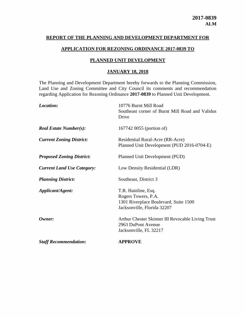
2017-0839 ALM REPORT OF THE PLANNING AND DEVELOPMENT DEPARTMENT FOR APPLICATION FOR REZONING ORDINANCE 2017-0839 TO PLANNED UNIT DEVELOPMENT JANUARY 18, 2018 The Planning and Development Department hereby forwards to the Planning Commission, Land Use and Zoning Committee and City Council its comments and recommendation regarding Application for Rezoning Ordinance 2017-0839 to Planned Unit Development. Location: 10776 Burnt Mill Road Southeast corner of Burnt Mill Road and Validus Drive Real Estate Number(s): 167742 0055 (portion of) Current Zoning District: Residential Rural-Acre (RR-Acre) Planned Unit Development (PUD 2016-0704-E) Proposed Zoning District: Planned Unit Development (PUD) Current Land Use Category: Low Density Residential (LDR) Planning District: Southeast, District 3 Applicant/Agent: T.R. Hainline, Esq. Rogers Towers, P.A. 1301 Riverplace Boulevard, Suite 1500 Jacksonville, Florida 32207 Owner: Arthur Chester Skinner III Revocable Living Trust 2963 DuPont Avenue Jacksonville, FL 32217 Staff Recommendation: APPROVE
Transcript of PUD Staff Report Template - COJ.net
2017-0839 ALM
REPORT OF THE PLANNING AND DEVELOPMENT DEPARTMENT FOR
APPLICATION FOR REZONING ORDINANCE 2017-0839 TO
PLANNED UNIT DEVELOPMENT
JANUARY 18, 2018
The Planning and Development Department hereby forwards to the Planning Commission,
Land Use and Zoning Committee and City Council its comments and recommendation
regarding Application for Rezoning Ordinance 2017-0839 to Planned Unit Development.
Location: 10776 Burnt Mill Road
Southeast corner of Burnt Mill Road and Validus
Drive
Real Estate Number(s): 167742 0055 (portion of)
Current Zoning District: Residential Rural-Acre (RR-Acre)
Planned Unit Development (PUD 2016-0704-E)
Proposed Zoning District: Planned Unit Development (PUD)
Current Land Use Category: Low Density Residential (LDR)
Planning District: Southeast, District 3
Applicant/Agent: T.R. Hainline, Esq.
Rogers Towers, P.A.
1301 Riverplace Boulevard, Suite 1500
Jacksonville, Florida 32207
Owner: Arthur Chester Skinner III Revocable Living Trust
2963 DuPont Avenue
Jacksonville, FL 32217
Staff Recommendation: APPROVE

2017-839 January 18, 2018
Page 2
GENERAL INFORMATION
Application for Planned Unit Development 2017-0839 seeks to rezone approximately 12.14
acres of land from Residential Rural-Acre (RR-Acre) and Planned Unit Development
(PUD) to PUD. The property is located within the Low Density Residential (LDR)
Functional Land Use Category of the 2030 Comprehensive Plan. The rezoning to PUD is
being sought so that the property can be developed for the use of senior housing. The site
will be developed with a maximum of 270,000 square feet of space.
Portions of the subject site were included within the boundaries of a previously approved
PUD (2016-0704). However, this boundary appears limited to a changing water line in the
adjacent wetlands area. The adjacent PUD allows for similar uses as the subject site (senior
housing).
CRITERIA FOR REVIEW
Pursuant to the provisions of Section 656.125 of the Zoning Code, the Planning and
Development Department, Planning Commission and City Council (including the
appropriate committee) shall evaluate and consider the following criteria of an application
for rezoning to Planned Unit Development.
(1) Is the proposed zoning district consistent with the 2030 Comprehensive Plan?
Yes. The Planning and Development Department finds that the subject property is located
in the Low Density Residential (LDR) functional land use category as defined by the Future
Land Use Map series (FLUMs) contained within the Future Land Use Element (FLUE)
adopted as part of the 2030 Comprehensive Plan. The LDR category is a category that
allows for an increase of maximum gross density of seven (7) units/acre when full urban
services are available. Generally, single-family detached housing will be the predominant
land use in this category, although mobile homes, patio homes, townhomes and multi-
family dwellings may also be permitted in appropriate locations. LDR lands to be used for
senior housing facilities as a secondary uses are consistent with the functional land use
category identified in the 2030 Comprehensive Plan provided a hospital is located within
three (3) miles of the facility.
(2) Does the proposed rezoning further the goals, objectives and policies of the 2030
Comprehensive Plan?
The evaluation of the goals, objectives and policies of the Comprehensive Plan can be
found later in this report.
(3) Does the proposed rezoning conflict with any portion of the City’s land use
Regulations?

2017-839 January 18, 2018
Page 3
The written description and the site plan of the intended plan of development, meets all
portions of the City’s land use regulations and furthers their intent by providing specific
development standards.
(1) Consistency with the 2030 Comprehensive Plan
In accordance with Section 656.129 Advisory recommendation on amendment of Zoning
Code or rezoning of land of the Zoning Code, the subject property is within the following
functional land use category as identified in the Future Land Use Map series (FLUMs): Low
Density Residential (LDR). This proposed rezoning to Planned Unit Development is
consistent with the 2030 Comprehensive Plan, and furthers the following goals, objectives
and policies contained herein, including:
Future Land Use Element (FLUE) Policy 1.1.16
Require mitigation of adverse land use impacts on adjacent uses during development and
redevelopment through:
1. Creation of like uses;
2. Creation of complementary uses;
3. Enhancement of transportation connections;
4. Use of noise, odor, vibration and visual/aesthetic controls; and/or
5. Other appropriate mitigation measures such as requirements for buffer zones and
landscaping between uses
FLUE Policy 1.1.22
Future development orders, development permits and plan amendments shall maintain
compact and compatible land use patterns, maintain an increasingly efficient urban service
delivery system and discourage urban sprawl as described in the Development Areas and
the Plan Category Descriptions of the Operative Provisions.
FLUE Policy 1.2.9
Require new development and redevelopment in the Central Business District, Urban
Priority Area, Urban Area, and Suburban Area to be served by centralized wastewater
collection and potable water distribution systems when centralized service is available to
the site. New septic tanks in this area may be permitted only as interim facilities pursuant to
the requirements of the Sanitary Sewer Sub-Element.
FLUE Goal 3
To achieve a well-balance and organized combination of residential, non-residential,
recreational and public uses served by a convenient and efficient transportation network,
while protecting and preserving the fabric and character of the City’s neighborhoods and
enhancing the viability of non-residential areas.
FLUE Objective 3.1
Continue to maintain adequate land designated for residential uses which can accommodate
the projected population and provide safe, decent, sanitary and affordable housing

2017-839 January 18, 2018
Page 4
opportunities for the citizens. Protect single-family residential neighborhoods by requiring
that any other land uses within single-family areas meet all applicable requirements
described in the Development Areas and the Plan Category Descriptions of the Objective
Provisions of the 2030 Comprehensive Plan and Land Development Regulations.
FLUE Policy 3.1.21
The City shall provide design standards in the Land Development Regulations to ensure
compatibility with adjacent uses and to protect neighborhood scale and character through
transition zones, bulk, massing, and height restrictions. The City shall consider the
feasibility and effectiveness of developing design standards for each Development Area, not
to include the Central Business District which has established design standards.
Recreation Open Space (ROS) Element Policy 2.2.2
The City shall require that all new single-family and multi-family developments (residential
developments) dedicate land for public parkland (active recreation parks) or provide
monetary contribution to the appropriate department.
ROS Policy 2.2.5
All multi-family developments of 100 units or more shall provide 150 square feet of active
recreation area per dwelling unit. There may be one area for each 100 units, or the areas
may be combined, subject to the approval by the Planning and Development Department.
(2) Consistency with the Concurrency Mobility and Management System
Pursuant to the provisions of Chapter 655 Concurrency and Mobility Management System
of the Ordinance Code, the development will be required to comply with all appropriate
requirements of the Concurrency and Mobility Management System (CMMSO) prior to
development approvals.
(3) Allocation of residential land use
This proposed Planned Unit Development intends to utilize lands for a residential use. This
proposed development will not exceed the projected holding capacity reflected in Table L-
20, Land Use Acreage Allocation Analysis For 2030 Comprehensive Plan’s Future Land
Use Element, contained within the Future Land Use Element (FLUE) of the 2030
Comprehensive Plan.
(4) Internal compatibility
This proposed PUD is consistent with the internal compatibility factors with specific
reference to the following:
2017-839 January 18, 2018
Page 5
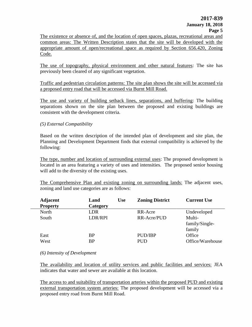
The existence or absence of, and the location of open spaces, plazas, recreational areas and
common areas: The Written Description states that the site will be developed with the
appropriate amount of open/recreational space as required by Section 656.420, Zoning
Code.
The use of topography, physical environment and other natural features: The site has
previously been cleared of any significant vegetation.
Traffic and pedestrian circulation patterns: The site plan shows the site will be accessed via
a proposed entry road that will be accessed via Burnt Mill Road.
The use and variety of building setback lines, separations, and buffering: The building
separations shown on the site plan between the proposed and existing buildings are
consistent with the development criteria.
(5) External Compatibility
Based on the written description of the intended plan of development and site plan, the
Planning and Development Department finds that external compatibility is achieved by the
following:
The type, number and location of surrounding external uses: The proposed development is
located in an area featuring a variety of uses and intensities. The proposed senior housing
will add to the diversity of the existing uses.
The Comprehensive Plan and existing zoning on surrounding lands: The adjacent uses,
zoning and land use categories are as follows:
Adjacent
Property
Land Use
Category
Zoning District Current Use
North LDR RR-Acre Undeveloped
South LDR/RPI RR-Acre/PUD Multi-
family/Single-
family
East BP PUD/IBP Office
West BP PUD Office/Warehouse
(6) Intensity of Development
The availability and location of utility services and public facilities and services: JEA
indicates that water and sewer are available at this location.
The access to and suitability of transportation arteries within the proposed PUD and existing
external transportation system arteries: The proposed development will be accessed via a
proposed entry road from Burnt Mill Road.

2017-839 January 18, 2018
Page 6
Any other factor deemed relevant to the limitation of the intensity of the development for
the benefit of the public health, welfare, and safety: A coordinated set of sign standards is
include within the Written Description that includes a project identity monument sign along
Burnt Mill Road and other project wide signage.
(7) Usable open spaces plazas, recreation areas.
The project will be developed with the required amount of open space and recreation areas
in accordance with Section 656.420, Zoning Code.
(8) Impact on wetlands
Wetlands
A wetlands survey map for this application site was extracted from the St Johns Water
Management District website and adapted with the use of the City’s GIS system. There are
approximately 2.8 acres of “Category II” wetlands located on the application site associated
with a channelized slough associated with Puncheon Gum Swamp Branch. A search of the
St Johns River Water Management District (SJRWMD) website did not produce an
application for an “Environmental Resource Permit” (ERP) or an application for wetlands
impact. A permit (ERP #86927-3) was issued on 9/16/2017 for A.C. Skinner lands to the
west of the rezoning application site for a borrowing pit and dewatering facilities.
According to the site plan some wetlands will be impacted that are in the flood zone.
An environmental resource permit from the St Johns River Water Management District will
be required as well as mitigation to offset the expected loss. There is also a possibility the
Water Management District could also affect change in the PUD site plan. Development
must also comply with the following objectives and policies of the 2030 Comprehensive
Plan, Conservation Coastal Management Element (CCME):
CCME Goal 4
To achieve no further net loss of the natural functions of the City’s remaining wetlands,
improve the quality of the City’s wetland resources over the long-term and improve the
water quality and fish and wildlife values of wetlands.
CCME Objective 4.1
The City shall protect and conserve the natural functions of its existing wetlands, including
estuarine marshes.
CCME Policy 4.1.1
The City shall encourage the placement of all watercourses, water bodies, buffer areas, and
wetlands having high functional values to be placed in a Conservation land use category,
Conservation zoning district and/or conservation easement as part of an application for a
land use amendment, rezoning and/or site plan approval process.

2017-839 January 18, 2018
Page 7
CCME Policy 4.1.5
The permitted uses within Category I and II wetlands shall be limited to the following land
uses and associated standards, provided such use is consistent with the Future Land Use
Map series (FLUMs):
1) Conservation uses, provided the following standards are met:
a) Dredge and fill: Dredging or filling of Category I and II wetlands shall not exceed more
than 5% of the wetlands on-site; and
b) Vegetation:
For Category I wetlands: All native vegetation outside the development area is maintained
in its natural state
For Category II wetlands: No more than 10% of the arial extent of the vegetation outside of
the development area may be altered or removed; and
2) Residential uses, provided the following standards are met:
a) Density/Dredge and fill: Where lots, except for lots of record as defined in the Future
Land Use Element, are located totally within the wetlands:
i) Density shall not exceed one (1) dwelling unit per five (5) acres; and
ii) Buildings shall be clustered together to the maximum extent practicable; and
iii) Dredging or filling shall not exceed 5% of the wetlands on-site; and
b) Vegetation:
3) Water-dependent and water-related uses, provided the following standards are met:
a) Vegetation:
For Category I wetlands: All native vegetation outside the development area is maintained
in its natural state
For Category II wetlands: No more than 10% of the arial extent of the vegetation outside of
the development area may be altered or removed; and
b) Boat facilities siting and operation: Boat facilities are further subject to Objective 10.1,
10.2, 10.3, 10.5 and 10.6 and their related policies of this element
4) Access to a permitted use, subject to the requirements of (a), (b), and (f) as noted in the
performance standards of Policy 4.1.3
5) Any use which can be shown to be clearly in the public interest, subject to the
requirements of (a), (b), (d) and (f) as noted in the standards outlined in Policy 4.1.3
6) For Category II wetlands only, Silvicultural uses are allowed, provided the following
standards are met:
Best Management Practices: Silviculture: Such activities are conducted in compliance with
the provisions of the “Silvicultural Best Practices Management Practices Manual”, as
may be amended, published by the Florida Division of Forestry, Department of
Agriculture and Consumer Services.
Flood Zone
Over 97 percent of the proposed PUD rezoning site (11.82 acres) is determined to be within
the 100 year flood zone. This area is associated with Puncheon Gum Swamp Branch.
In addition, a portion of the PUD site is within a floodway found along the channel on
the southwest boundary of the application site. The proposed building is located outside
of the floodway but a portion of the parking lot is. Flood hazard areas identified by the
Flood Insurance Rate Map are identified as Special Flood Zone Area (SFHA). SFHA

2017-839 January 18, 2018
Page 8
are defined as the area that will be inundated by the flood event having a 1-percent
chance of being equaled or exceed in any given year. The 1-percent annual change
flood is also referred to as the base flood or 100-year flood. SFHAs are labeled as
“AE”. Moderate flood hazard areas, are the areas between the limits of the base flood
and the 0.2-percent-annual-change (or 500-year flood). Any development within the
floodplain will be required to comply with Chapter 652, the Floodplain Management
Ordinance:
CCME Policy 1.4.4
The City shall require all development within the 100-year floodplain to be in strict
conformance with all applicable federal, State, regional and local development
regulations.
CCME Objective 2.7
The City shall protect the hydrological and ecological benefits of floodplain areas, such as
water quality, fish and wildlife habitat, and prevention of downstream flooding.
CCME Policy 2.7.1
The City shall continue to define the surface hydrology of the area to determine floodplain
vulnerability and sensitivity, and will determine appropriate protection measures.
CCME Policy 2.7.3
The City shall protect appropriate floodplain areas for the public benefit and restore
degraded floodplain areas by:
A. Land acquisition or conservation easement acquisition;
B. Regulation, including setbacks, buffer zones, designated wildlife corridors, low
density zoning, performance standards and open space requirements; and
C. Incentives, including tax benefits and transfer of development rights
(9) Listed species regulations
No wildlife survey was required as the project is less than the 50-acre threshold.
(10) Off-street parking including loading and unloading areas.
The site will generally be developed in accordance with Part 6 of the Zoning Code with the
following exceptions:
All senior housing permitted in Section IV.A.1.a-c of the Written Description
(except independent living): One (1) space per every two (beds)
Independent Living: One (1) space per two (2) units
Staff parking: One (1) space per employee
One (1) off-street loading space
Required vehicle parking may be provided in garages, driveways, carports or
common parking. Tandem parking is also permitted.

2017-839 January 18, 2018
Page 9
A minimum of ten (10) off-street bicycle parking spaces shall be provided
(11) Sidewalks, trails, and bikeways
The project will contain a pedestrian system that meets the 2030 Comprehensive Plan.
SUPPLEMENTAL INFORMATION
Upon visual inspection of the subject property on January 5, 2018, the required Notice of
Public Hearing sign was posted.
RECOMMENDATION
Based on the foregoing, it is the recommendation of the Planning and Development
Department that Application for Rezoning 2017-0839 be APPROVED with the following
exhibits:
1. The original legal description dated October 9, 2017
2. The original written description dated October 9, 2017
3. The original site plans dated June 23 and October 9, 2017
Based on the foregoing, it is the recommendation of the Planning and Development Department
that the application for Rezoning 2017-0839 be APPROVED

2017-839 January 18, 2018
Page 10
Aerial
Source: Staff, Planning and Development Department
Date: 01.02.2018

2017-839 January 18, 2018
Page 11
Subject Property
Source: Staff, Planning and Development Department
Date: 01.05.2018
Access road under development for subject property
Source: Staff, Planning and Development Department
Date: 01.05.2018

2017-839 January 18, 2018
Page 12
Adjacent property to the east
Source: Google StreetView
Date: 01.05.2018
Adjacent property to the south and west across Burnt Mill Road
Source: Staff, Planning and Development Department
Date: 01.05.2018

2017-839 January 18, 2018
Page 13