PUD Narrative for ASLD Supplier Site B
38
RVi Planning + Landscape Architecture CivTech 120 S. Ash Avenue Tempe, Arizona, 85281 10605 N. Hayden Road #140, Scottsdale, AZ 85260 WoodPatel 2051 W. Northern Avenue #100, Phoenix, AZ 85021 PUD Narrative for ASLD Supplier Site B A +/- 131-acre master planned industrial hub located at the northeast corner of 7th Street and Alameda Road. Case #: Z-58-20 Bergin, Frakes, Smalley, Oberholtzer, PLLC 4343 E. Camelback Road, Suite 210, Phoenix, Arizona, 85018 Prepared for: Arizona State Land Department 1616 W. Adams Street, Phoenix, AZ 85007 1st Submittal: November 7, 2020 2nd Submittal: November 25, 2020 Hearing Draft Submittal: December 3, 2020 City Council Approved: January 20, 2020
Transcript of PUD Narrative for ASLD Supplier Site B

RVi Planning + Landscape Architecture
CivTech
120 S. Ash AvenueTempe, Arizona, 85281
10605 N. Hayden Road #140, Scottsdale, AZ 85260
WoodPatel
2051 W. Northern Avenue #100, Phoenix, AZ 85021
PUD Narrative forASLD Supplier Site BA +/- 131-acre master planned industrial hub located at the northeast corner of 7th Street and Alameda Road.
Case #: Z-58-20
Bergin, Frakes, Smalley, Oberholtzer, PLLC
4343 E. Camelback Road, Suite 210, Phoenix, Arizona,
85018
Prepared for:Arizona State Land Department1616 W. Adams Street, Phoenix, AZ 85007
1st Submittal: November 7, 20202nd Submittal: November 25, 2020
Hearing Draft Submittal: December 3, 2020City Council Approved: January 20, 2020
052778
DATE STAMP

Page | i
PRINCIPALS AND DEVELOPMENT TEAM APPLICANT: CITY OF PHOENIX PLANNING & DEVELOPMENT DEPARTMENT Contact: Joshua Bednarek, LEED AP ND 200 W. Washington Street, 3rd Floor, Phoenix, AZ 85002 (602) 256-3555, [email protected]
LAND OWNER: ARIZONA STATE LAND DEPARTMENT Contact: Mark Edelman, AICP 1616 W. Adams Street, Phoenix, AZ 85007 (602) 542-6331, [email protected]
LAND PLANNER: RVI PLANNING & LANDSCAPE ARCHITECTURE Contact: Alex Stedman 120 S. Ash Avenue, Tempe, Arizona 85281 (480) 994-0994, [email protected]
LAND USE ATTORNEY: BERGIN, FRAKES, SMALLEY, & OBERHOLTZER, PLLC Contact: Carolyn Oberholtzer 4343 E. Camelback Road, Suite 210, Phoenix, Arizona, 85018 (602) 888-7860, [email protected]
CIVIL ENGINEER: WOODPATEL Contact: Michael Young, PE, LEED AP 2051 W. Northern Avenue #100, Phoenix, AZ 85021 (602) 336-7966, [email protected]
TRAFFIC ENGINEER: CIVTECH Contact: Dawn Cartier, PE 10605 N. Hayden Road #140, Scottsdale, AZ 85260 (480) 659-4250, [email protected]

Page | ii
TABLE OF CONTENTS 1. Purpose & Intent ................................................................................................. 5
1a. The Arizona State Land Department (ASLD) ............................................................... 5
1b. Planned Unit Development ......................................................................................... 5
1c. Project Overview and Goals ......................................................................................... 6
1d. General Plan Amendment ............................................................................................ 6
2. Existing Site Conditions ....................................................................................... 7
3. Development Plan ............................................................................................... 7
4. Permitted Uses .................................................................................................... 8
5. Development Standards ....................................................................................... 9
5a. Development Standards Table .................................................................................... 9
5b. Development Standards of General Applicability .................................................... 12
6. Area Plan Conformance ....................................................................................... 15
6a. Conformance with the Deer Valley Character Plan (DVCP) ...................................... 15
6b. Conformance with Deer Valley Airport Overlay ........................................................ 17
6c. Conformance with Complete Streets Guidelines ...................................................... 17
7. Design Guidelines ............................................................................................... 18
8. Sustainability ..................................................................................................... 20
9. Site Infrastructure .............................................................................................. 21
9a. Stormwater and Drainage .......................................................................................... 21
9b. Water and Wastewater ............................................................................................... 21

Page | iii
LIST OF FIGURES Figure 1: Regional Context Map Figure 2: Current General Plan Land Use Figure 3: Proposed General Plan Land Use Figure 4: Existing Zoning Figure 5: Proposed Zoning Figure 6: Conceptual Land Use Plan Figure 7: Conceptual Circulation Plan Figure 8: Deer Valley Airport Overlay
APPENDIX Appendix A: Legal Descriptions Appendix B: Comparative Zoning Table

Page | 5
1. PURPOSE & INTENT
1a. The Arizona State Land Department (ASLD) The Arizona State Land Department (ASLD) manages over 9.2 million acres of state trust land in Arizona. Since 1915, the ASLD’s mission has been to manage the assets of a multi-generational perpetual trust in alignment with the interests of the Trust’s 13 beneficiaries and Arizona’s future. The mission statement of the ASLD is as follows:
“To manage State Trust lands and resources to enhance value and optimize economic return for the Trust beneficiaries, consistent with sound business management principles, prudent stewardship, and conservation needs supporting socio-economic goals for citizens here today and future generations. To act in the best interest of the Trust for the enrichment of the beneficiaries and preserve the long-term value of the State Trust lands.”
State Trust land is often misunderstood in terms of both its character and management. Trust land is different from public land such as parks or National Forests. Trust lands are managed by the ASLD to generate revenue for K-12 schools and 13 additional institutional beneficiaries. The Trust accomplishes its mission through its sale and lease of Trust lands for grazing, municipal, residential, commercial, mining, and open space purposes.
The ASLD, serving as the fiduciary for the Trust, is required by the Arizona Constitution to receive maximum value for the sale or lease of Trust lands for the benefit of the Trust. Given this Constitutional mandate, it is incumbent upon ASLD to carefully plan these properties to maximize their ultimate value. Accordingly, the ASLD is in the process of re-evaluating the existing development plans for the Trust lands in the area and is working with the City of Phoenix to develop plans that are appropriate for the area and that will meet market demands.
1b. Planned Unit Development The Planned Unit Development (“PUD”) zoning district is authorized by Chapter 6, Section 671 of the Zoning Ordinance of the City of Phoenix (“Phoenix Zoning Ordinance”). A PUD is intended to be a stand-a-lone document that sets forth the regulatory framework, including permitted uses, development standards and design guidelines, for a particular project (“PUD Regulations”). The PUD may only modify provisions within the Phoenix Zoning Ordinance and does not modify other City of Phoenix codes, regulations or requirements. A PUD may include background information and narrative discussion, including purpose and intent statements,

Page | 6
which are intended to illustrate the overall character and vision for the development. Such statements are not regulatory and are not requirements to be enforced by the City of Phoenix.
The PUD regulations apply to all property within the PUD project boundary. The PUD regulations supersede and replace all applicable Phoenix Zoning Ordinance requirements. If there is a conflict between PUD regulations and the Phoenix Zoning Ordinance, including the design guidelines within the Phoenix Zoning Ordinance, the terms of this PUD shall apply. If a provision is not addressed by the PUD, then the Phoenix Zoning Ordinance controls.
1c. Project Overview and Goals This PUD for ASLD Supplier Site B rezones approximately 109-acres of vacant State Trust land located within the Deer Valley Village. The Site is located at the northeast corner of 7th Street and Alameda Road. See Figure 1: Regional Context Map. In alignment with the City’s General Plan land use designations for the subject property, as amended through a concurrent minor General Plan land use amendment, this application proposes development of an industrial supplier site tailored to support the employment development located within the North Phoenix 3,500 PUD (case # Z-37-20-1). The primary goal of this PUD request is to allow for the industrial development of the site to support major economic and employment drivers within the region.
Additional goals and objectives of the ASLD Supplier Site B PUD are to:
• Enhance the value of the State Trust land on behalf of the ASLD’s beneficiaries. • Establish entitlement flexibility to support needs of the industrial suppliers that will serve
the major employment generators within the region and benefit the region and City as a whole.
• Establish development and design standards to ensure land use compatibility with surrounding uses to create an appropriately sited industrial development.
1d. General Plan Amendment The Site currently has a General Plan land use designation of Commerce/Business Park as shown in Figure 2: Current General Plan Land Use. This PUD request is accompanied by a Minor General Plan Amendment request to modify the Site’s land use designations to Mixed Use (Commerce/Business Park/Industrial) as shown in Figure 3: Proposed General Plan Land Use. This revised land use designation will support the industrial development planned for this Site and in the North Phoenix region.

Page | 7
The Site is also governed by the following additional land planning documents:
• Deer Valley Character Area Plan • Deer Valley Airport Overlay
The ASLD Supplier Site B PUD will comply with the above-mentioned planning documents.
2. EXISTING SITE CONDITIONS The ASLD Supplier Site B is approximately 109 gross acres in size and is located within the Deer Valley Village at the northeast corner of 7th Street and Alameda Road. The Site, which is generally flat and does not include significant topographical or natural features, is currently undeveloped. As shown in Table 1: Surrounding Uses, below, the Site is surrounding by other vacant lands with Industrial and Commerce/Business Park land use designations.
Table 1: Surrounding Uses
Location APN General Plan Zoning Land Use
North N/A Commerce / Business Park, Future Parks/Open Space or
1 du/ac S-1 Vacant State Trust Land
West N/A, 212-19-003E
Commerce / Business Park, Floodplain S-1
Vacant State Trust Land, Bureau of Reclamation, Landscaping, Trucking,
Salvage
South N/A Industrial CP/GCP PCD
Vacant State Trust Land, Bureau of Reclamation
East N/A Commerce / Business Park County Vacant State Trust Land

Page | 8
3. DEVELOPMENT PLAN The ASLD Supplier Site B PUD provides the regulatory framework for development of an industrial supplier site to promote regional economic development. As shown on Figure 4: Existing Zoning, the Site is currently zoned S-1, and rezoning the Site to PUD will establish the necessary development standards and permitted uses to allow for the development of the property as an industrial supplier site while maintaining compatibility with surrounding uses. See Figure 5: Proposed Zoning.
The ASLD Supplier Site B PUD provides for a variety of industrial land use types that are consistent and compatible with adjacent properties. The flexibility and enhancement of site design standards proposed with this PUD offers a desirable improvement over conventional zoning standards and directly promotes the appropriate and efficient use of land and infrastructure. See Figure 6: Conceptual Land Use Plan.
4. LAND USES Uses allowed within the ASLD Supplier Site B PUD include the following:
• All uses permitted in the A-2 Light Industrial District per Zoning Ordinance Section 628.B&C.
• All uses permitted in the Commerce Park District: General Commerce Park Option per Zoning Ordinance Section 626.F.
PROHIBITTED USES
• Single family and multifamily residential development

Page | 9
5. DEVELOPMENT STANDARDS
5a. Development Standards Table Development Standards are essential to maintaining land use compatibility between neighboring uses. This ASLD Supplier Site B PUD utilizes the A-2 Industrial District with a MR Mid-Rise District overlay as base zoning designations with modifications indicated below. Development standards within this PUD are generally in conformance with the standards of these districts with exceptions to promote enhanced perimeter buffering standards and allow for structure heights that facilitate the unique needs of the future industrial uses on the property. These standards are identified in Table 2: Development Standards.
Table 2: Development Standards
Building Height: Eighty (80) foot maximum height. In addition to the building height exceptions outlined in the Zoning Ordinance (Section 701.B), non-habitable mechanical equipment and structures that may include, but are not limited to, elements such air separators, exhaust pipes, storage tanks, and gas processing equipment are permitted up to one hundred fifty (150) feet in height.
Open Space: For any property development in excess of fifty-six (56) feet: A minimum of ten (10%) percent of the parcel’s total net area shall be open space with appropriate landscaping and other employee-oriented amenities as identified within Section 7:Design Guidelines.
Building setback adjacent to a collector / arterial street:
Min. fifty (50) feet
Building setback adjacent to a non- collector / non-arterial street:
Min. twenty (20) feet
Building setback not adjacent to a street:
Min. zero (0) feet

Page | 10
Table 2: Development Standards (Continued) Screening Screening for Parking or Loading and Unloading Areas where within one hundred fifty (150) feet of a Residence District:
Per A-2 Code - For employee and customer parking a four (4) to six (6) foot wall or landscaped berm is required. The wall may be three (3) feet high if the parking area is located in a yard as specified in Section 628.E.2.b(1). Per A-2 Code - In areas used for truck parking, loading or unloading, an eight (8) foot high wall is required.
Screening for Open Storage Use:
Per A-2 Code - Any outside storage or use within one hundred (100) feet of a residential district or any public street shall be screened by a six (6) foot high solid fence or wall. Per A-2 Code - Height of Open Storage: Open storage shall be no higher than six (6) feet plus one (1) foot in height for every additional three (3) feet of setback from a property line. If the storage area is within one hundred fifty (150) feet of a public street, screening in the addition to the required six (6) foot high solid fence or wall shall include fifteen (15) gallon trees spaced no more than twenty-five (25) feet apart and with an adequate watering system.
Screening for Open Storage Use:
Per A-2 Code - Except for vehicle parking areas, no outdoor uses, outdoor storage, or open buildings shall be within seventy-five feet of a public street.
Screening for Surface Parking Per MR Code - For any site development in excess of fifty-six (56) feet: all surface parking must be buffered by landscaping regardless of whether located in side yards or rear yards.

Page | 11
Table 3: Landscape Development Standards
Landscape setback adjacent to a collector / arterial street:
Min. fifty (50) feet
Landscape setback adjacent to a non-collector / non-arterial street:
Min. twenty (20) feet
Landscape setback not adjacent to a street:
Min. zero (0) feet
STREETSCAPE, ALONG ARTERIAL AND COLLECTOR ROAD FRONTAGES
Plant Type: Minimum Planting Size
Trees* Min. 2-inch caliper (50% of required trees)
Min. 3-inch caliper or multi-trunk tree (25% of required trees)
Min. 4-inch caliper or multi-trunk tree (25% of required trees)
Shrubs Min. five (5) 5-gallon shrubs per tree
Groundcover Min. 60% live coverage
DETACHED SIDEWALKS ALONG ARTERIAL AND COLLECTOR STREETS
Detached Sidewalk**** Sidewalk Width: Minimum 6-feet
Landscape Strip: Minimum ten (10) feet
PARKING LOT AREA
Interior surface area (exclusive of perimeter landscaping and all required setbacks)
Min. 10%
Landscaped planters At ends of each row of parking & approximately every 110'
Landscaped planters**, single row of parking
Min. 120 sq. ft.***
Landscaped planters**, double row of parking
Min. 240 sq. ft.***
Additional parking lot landscaping As needed to meet 10% minimum requirement, evenly distributed throughout the entire parking lot. Min. interior dimension 5' (length and width).
Plant Type: Minimum Planting Size
Trees Min. 2-inch caliper (60% of required trees)
Min. 1-inch caliper (40% of required trees)
Shrubs Min. five (5) 5-gallon shrubs per tree

Page | 12
Table 3: Landscape Development Standards (Continued) RETENTION BASINS
Stormwater Management Where conditions allow, retention basis shall be planted with a minimum of 60% live coverage of plants to serve as bioswales reducing urban runoff and promoting vegetation on the site
Plant Type: Minimum Planting Size
Trees Min. 2-inch caliper (40% of required trees)
Min. 1-inch caliper (60% of required trees) Shrubs Min. five (5) 5-gallon shrubs per tree
* Minimum double row of trees planted 20 feet on center or equivalent groupings.
** Measured from inside face of curb to inside face of curb.
*** Not to exceed the length of a standard City of Phoenix parking stall. Modifications to the square
footage may be approved by Planning and Development Department if the overall intent of the
standard is being met.
****Standards shall only apply to new sidewalk construction and shall not affect any existing
sidewalks along arterial and collector roads. Existing sidewalks along arterial and collector roads
may remain in place.
5b. Development Standards of General Applicability Development standards relating to the following elements within ASLD Supplier Site B shall adhere to City of Phoenix Zoning Ordinance standards except as modified through this PUD.
PARKING
The minimum number of required parking spaces shall be as set forth is Section 702 of the Phoenix Zoning Ordinance. This provision shall not limit the ability of the applicant or end user to apply for a zoning adjustment application to further modify any development standard or ordinance provision relating to parking.
FENCES AND WALLS
All screen walls and fences shall comply with the Phoenix Zoning Ordinance, Section 703: Landscaping, Fences and walls.

Page | 13
SHADE
Shading of pedestrian spaces is necessary for summer comfort. Any plazas, courtyards, and sidewalks must contain spaces within them that are shaded in the summer months, but that allow for sun penetration in the winter months. The following shade provisions apply:
• Minimum 50% shading of all publicly accessible sidewalks and walkways by means of vegetation at maturity and/or shade structures.
• Minimum 75% shading of all publicly accessible sidewalks and paths along arterial and collector roadways by means of vegetation at maturity and/or shade structures.
LIGHTING
Exterior lighting throughout the site shall be in conformance with the provisions set forth in City of Phoenix Zoning Ordinance Section 507.Tab.A.II.A.8: Site Lighting and in Phoenix City Code Section 23-100: Outdoor Lighting.
SIGNS
Signs are allowed within ASLD Supplier Site B pursuant to City of Phoenix Zoning Ordinance Section 705. A comprehensive sign plan shall be processed for approval for all commercial uses in accordance with Section 705.E.2 of the Phoenix Zoning Ordinance.
PEDESTRIAN CIRCULATION
Pedestrian circulation and connectivity is required for ASLD Supplier Site B. See Figure 7: Conceptual Circulation Plan. The following provisions shall guide pedestrian connectivity across the site:
• A publicly accessible detached meandering sidewalk shall be provided along perimeter arterial and collector street frontages. This sidewalk shall be a minimum 75% shaded at maturity.
• Pedestrian accesses to the site from the sidewalk should be attractive and inviting and separated in distance from vehicular traffic to provide a design that accentuates and prioritizes the importance and care of patrons arriving to the site on foot.
• Generally, connect all public building entrances and exits, parking areas, and all public sidewalks utilizing the minimum possible distance and providing the most direct route.

Page | 14
• Building entrances should be identifiable at a pedestrian scale and directly accessible from a public sidewalk. The developer shall provide ADA compliant pedestrian access to and from the site, connecting the sidewalk / sidewalks and the main entrance ot the building in the most direct route. At properties located in signalized intersections (or future signalized intersections), additional ADA complaint pedestrian paths shall be provided from the traffic signal (or future site of a traffic signal) to the entrances of the building in the most direct route.
• Appropriate street lighting shall be provided in accordance with City of Phoenix Standards.
• Sidewalks along the site perimeter shall be detached and shade shall be provided along both sides of the sidewalk with single-trunk trees. Single trunk trees should alternate with other vegetation within the landscape strip to discourage pedestrians from crossing mid-block.
• All cross access agreements within the development shall contain a pedestrian pathway.
• Enhanced surfacing materials, such as stamped or colored concrete or other pavement treatments, that visually contrast with the adjacent parking and drive aisle surfaces shall be provided to delineate all areas where pedestrian paths cross drive aisles.
• The Street Transporation Department has identified a multi-use trail bisecting the site from 7th Street to Alameda Road. New development along this trail corridor shall include the dedication of a multi-use trail easement (MUTE) and improvements of a landscaped multi-use trail (MUT).
BIKE INFRASTUCTURE
Bike lanes exist along both 19th Avenue and Pinnacle Peak Road. Development within ASLD Supplier Site A shall provide bike parking in accordance with City of Phoenix standards. Bike parking areas shall:
• be paved with a solid surface; • include a ramp for access; • be located within close proximity to building entries; and • have a minimum 50% shade coverage.

Page | 15
6. AREA PLAN CONFORMANCE The ASLD Supplier Site B is governed by a series of applicable area plans to ensure the site’s regional compatibility. These plans include the Deer Valley Character Plan, Deer Valley Airport Overlay Plan, and the city’s Complete Streets Guidelines. Below is a discussion of how the ASLD Supplier Site B will be in conformance with these above-mentioned area plans.
6a. Conformance with the Deer Valley Character Plan (DVCP) The ASLD Supplier Site B is located within the Deer Valley Village and is governed by the Deer Valley Character Plan (DVCP). The Deer Valley Village is distinguished by its attraction for business, variety of housing types and density ranges, the Phoenix Deer Valley Airport, and easy access to the regional freeway system. The Deer Valley is also characterized by its considerable commerce and industrial land which is highly suitable to area employment and commerce needs. Below is a description of the ways in which the ASLD Supplier Site B is in conformance with relevant objectives of the DVCP.
LAND USE GOALS
• Support General Plan Land Use Map and zoning changes that will facilitate the location of employment generating uses in each of the designated employment centers (DVCP pg. 10).
• Encourage land uses that promote the growth of entrepreneurs or new businesses in Phoenix in appropriate locations (DVCP pg. 10).
• Discourage the location of incompatible uses near base industrial clusters (DVCP pg. 10).
• Maximize use of existing infrastructure and carrying capacity by encouraging redevelopment and infill (DVCP pg. 10).
Response: This PUD establishes the necessary conditions to support robust industrial development of this Site. This will be an employment generating use which will support regional employment centers including the North Phoenix 3,500 PUD employment hub. The rezoning of this site to PUD will facilitate new business investment within this industrial area of the DVCP. Given that this area is already home to several industrial/employment uses, this is an appropriate location for continued industrial development expansion capitalizing on existing infrastructure carrying capacity and land use compatibility.

Page | 16
DESIGN
• Pursue creative, innovative, and environmentally-sound methods to capture and use stormwater and urban runoff for beneficial purposes (DVCP pg. 13).
• Encourage construction plans that reflect a systematic and integrated approach to building design, civil engineering, and landscape architecture in order to maximize the potential for rainwater harvesting and stormwater retention for landscape watering (DVCP pg. 13).
Response: Detailed engineering will be provided during future phases of the development process identifying specifics of the grading and drainage plan to capture and manage onsite stormwater. A combination of retention basis and bioswales will reduce urban runoff and promote vegetation on the site. The ultimate construction plans will integrate the building design, civil engineering, and landscape design to maximize this stormwater management potential.
DESIGN PRINCIPLES
• Design industrial sites to be well screened from adjacent sensitive land uses such as residential (DVCP pg. 14).
Response: While the ASLD Supplier Site B is not located adjacent to sensitive land uses such as residential, appropriate screening measures will be implemented to promote an attractive streetscape and to ensure compatibility with adjacent uses. Table 2: Development Standards identifies enhanced building and landscape setback requirements for the site. Per the landscape design guidelines identified in Section 5b, a double row of shade trees is required along the site’s arterial and collector street frontages and 60% live coverage of plant materials are required within the front yard area. Screen walls will be provided were appropriate and necessary.
OPPORTUNITIES FOR GROWTH & INVESTMENT
• Maintaining Shaded Streetscapes: Many parts of the village have a lack of walkable, shaded streetscapes, especially in areas with existing transit. Enhancements to the streetscape should be encouraged whenever possible (DVCP pg. 17).
Response: The ASLD Supplier Site B will be in conformance with the Complete Streets elements identified in Section 6d of this Narrative. These Complete Street elements include the provision of tree-lined detached sidewalks with 75% shading along arterial and collector roadways. These enhanced sidewalk improvements will support pedestrian circulation within the area.

Page | 17
6b. Conformance with Deer Valley Airport Overlay Section 658 of the Phoenix Zoning Ordinance outlines regulations relating to the Deer Valley Airport Overlay. The Deer Valley Airport Overlay (DVAO) is intended to protect the health, safety and welfare of persons and property in the vicinity of the Deer Valley Airport and to protect the long term viability of the airport by ensuring land use compatibility with airport operations, projecting navigable airspace from physical encroachment, and requiring permanent notice of flight operations to property owners.
As shown on Figure 8: Deer Valley Airport Overlay, the ASLD Supplier Site B site is located within Area 1 of the Deer Valley Airport Overlay. This is the least restrictive portion of the DVAO. Per Area 1 of the DVAO, the underlying zoning shall establish the allowable height for a parcel. In this case, this the height standard identified within Table 2: Development Standards establishes the allowable height for the site. Note that all heights shall be measured from the existing natural grade of the site.
Per the DVAO Avigation Notice Requirement, the property owner shall provide a copy of the recorded avigation notification to the Planning and Development Department when applying for a building permit. This notice shall apply to the expansion of an existing building or new construction great than 2,000 square feet in size.
6c. Conformance with Complete Streets Guidelines In 2018 the City of Phoenix adopted Complete Streets Design Guidelines with the goal promoting health and safety through active streetscapes. Streets within the ASLD Supplier Site B PUD shall conform to the following elements of the Complete Streets Design Guidelines:
• The unique character of the area shall be considered during the design of street projects. • Streets shall be designed to promote safely for all users, particularly children, the elderly,
those with disabilities, transit users and more vulnerable modes (walking, bicycling, transit).
• Shade shall be a primary technique to reduce ambient temperatures and to reduce direct sunlight exposure for pedestrians and cyclists.
• Streetscape designs shall include pedestrian infrastructure with pedestrian through zones free of impediments.
• Detached sidewalks will be provided along arterial and collector roadways. These detached sidewalks will be located between a double row of trees which will provide 75% shading at full maturity.

Page | 18
• A multi-use trail is planned to bisect the site from 7th Street to Alameda Road. A multi-use trail easement (MUTE) and landscaped multi-use trail (MUT) improvements will be required to be provided as the site develops.
7. DESIGN GUIDELINES The ASLD Supplier Site B development plan will promote flexibility in uses and site design while providing consistent design standards and guidelines to direct development within the site. The design guidelines identified below serve as a tool to ensure ongoing compatibility across the site as the project develops. The ASLD Supplier Site B will adhere to the following PUD Design Expectations:
SUSTAINABILITY
Objective – Provide Thermal Comfort for all Users
• Minimum 50% shading of all publicly accessible sidewalks and walkways by means of vegetation at maturity and/or shade structures.
• Minimum 75% shading of all publicly accessible sidewalks and trails along arterial and collector roadways by means of vegetation at maturity and/or shade structures.
ARCHITECTURAL DESIGN
Objective – Visual interest with unified elements to establish a sense of place
• Incorporating innovative textures, materials, colors: Building facades facing arterial roadways shall incorporate a minimum of two (2) different materials.
• Distinct Entry Features: Public building entries are to be clearly identifiable and shall incorporate functional shade elements such as awnings and canopies to create a comfortable entry experience while addressing pedestrian scale.

Page | 19
OPEN SPACE DESIGN
Objective – Provide diversified amenities for optimum recreational use and gathering places for community interaction
• Improved plazas, courtyards, break areas: A minimum of one (1) enhanced pedestrian plaza and/or promenade shall be provided within commercial parcels that exceed five (5) acres in size. The plaza and/or promenade shall be a minimum of 500 square feet and shall include shading and seating elements as well as landscaping elements including enhanced surfacing materials (e.g. stamped or colored concrete), specimen plantings, and lighting.
SITE DESIGN / DEVELOPMENT
Objective – Innovative design of access, circulation, privacy, security, shelter, and other factors to create a unique location that complements the surrounding context
• Mitigation of adverse effects (screening, landscape buffers, wall heights, etc.): Building and landscape setbacks are to be provided according to the standards identified in Table 2: Development Standards. Front setback areas to be enhanced by providing the following:
o Double row of trees o 60% live coverage by landscape materials o Parking areas to be screened minimum 30-inch solid screen wall and
associated landscaping.
LANDSCAPING ENHANCEMENTS
Objective – Provide shade and soften the look of the development to create a more natural environment
• Maturity of trees: Trees provided along arterial streets are to meet City of Phoenix minimum required caliper sizes in accordance with Section 507, Tab A.
• Xeriscaping: Drought tolerant plants identified on the Arizona Municipal Water Users Association (AMWUA) Low Water Plant List shall make up a minimum of 75% of any approved landscape palette.
Page | 20
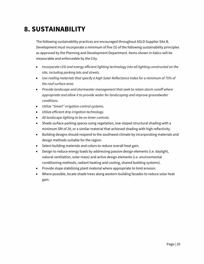
8. SUSTAINABILITY The following sustainability practices are encouraged throughout ASLD Supplier Site B. Development must incorporate a minimum of five (5) of the following sustainability principles as approved by the Planning and Development Department. Items shown in italics will be measurable and enforceable by the City.
• Incorporate LED and energy efficient lighting technology into all lighting constructed on the site, including parking lots and streets.
• Use roofing materials that specify a high Solar Reflectance Index for a minimum of 75% of the roof surface area.
• Provide landscape and stormwater management that seek to retain storm runoff where appropriate and allow it to provide water for landscaping and improve groundwater conditions.
• Utilize “Smart” irrigation control systems. • Utilize efficient drip irrigation technology. • All landscape lighting to be on timer controls. • Shade surface parking spaces using vegetation, low-sloped structural shading with a
minimum SRI of 29, or a similar material that achieved shading with high reflectivity. • Building designs should respond to the southwest climate by incorporating materials and
design methods suitable for the region. • Select building materials and colors to reduce overall heat gain. • Design to reduce energy loads by addressing passive design elements (i.e. daylight,
natural ventilation, solar mass) and active design elements (i.e. environmental conditioning methods, radiant heating and cooling, shared building systems).
• Provide slope stabilizing plant material where appropriate to limit erosion. • Where possible, locate shade trees along western building facades to reduce solar heat
gain.
Page | 21
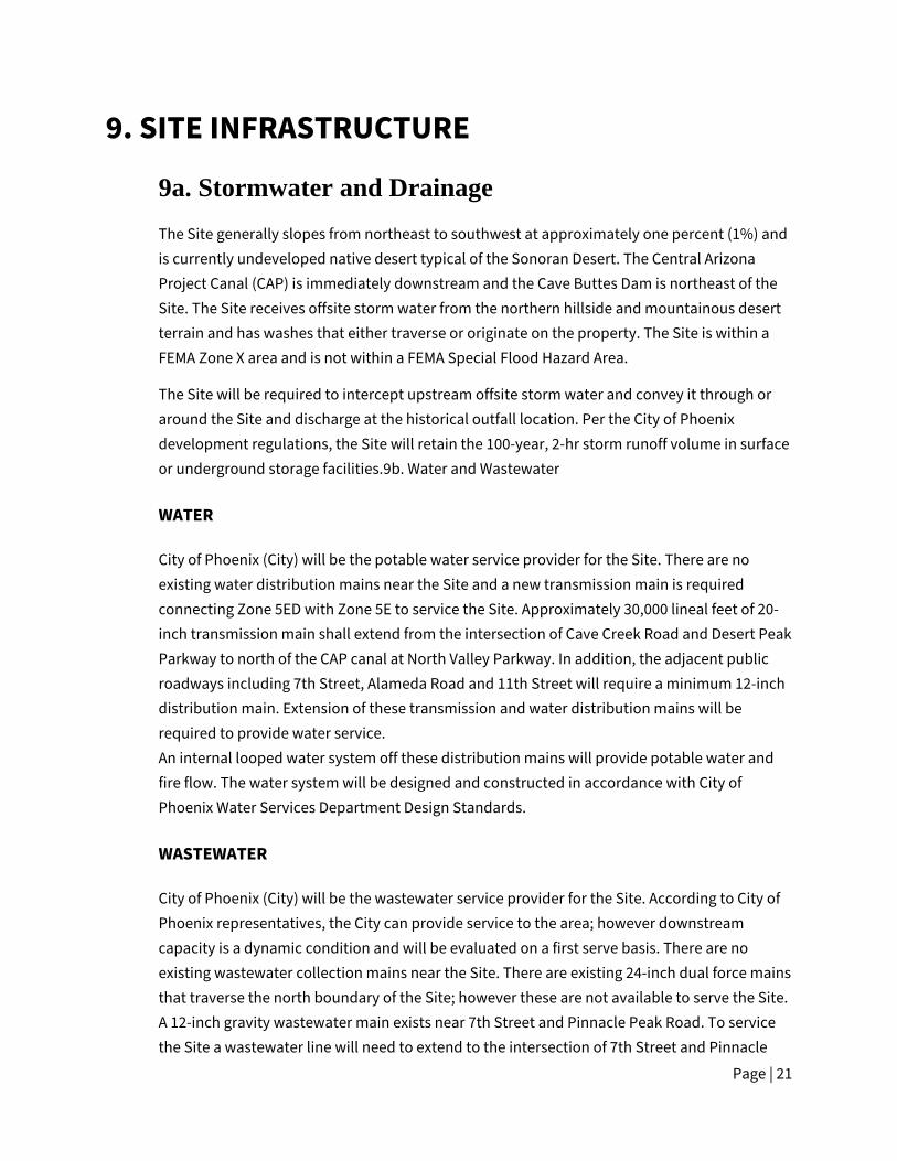
9. SITE INFRASTRUCTURE
9a. Stormwater and Drainage The Site generally slopes from northeast to southwest at approximately one percent (1%) and is currently undeveloped native desert typical of the Sonoran Desert. The Central Arizona Project Canal (CAP) is immediately downstream and the Cave Buttes Dam is northeast of the Site. The Site receives offsite storm water from the northern hillside and mountainous desert terrain and has washes that either traverse or originate on the property. The Site is within a FEMA Zone X area and is not within a FEMA Special Flood Hazard Area.
The Site will be required to intercept upstream offsite storm water and convey it through or around the Site and discharge at the historical outfall location. Per the City of Phoenix development regulations, the Site will retain the 100-year, 2-hr storm runoff volume in surface or underground storage facilities.9b. Water and Wastewater
WATER
City of Phoenix (City) will be the potable water service provider for the Site. There are no existing water distribution mains near the Site and a new transmission main is required connecting Zone 5ED with Zone 5E to service the Site. Approximately 30,000 lineal feet of 20-inch transmission main shall extend from the intersection of Cave Creek Road and Desert Peak Parkway to north of the CAP canal at North Valley Parkway. In addition, the adjacent public roadways including 7th Street, Alameda Road and 11th Street will require a minimum 12-inch distribution main. Extension of these transmission and water distribution mains will be required to provide water service. An internal looped water system off these distribution mains will provide potable water and fire flow. The water system will be designed and constructed in accordance with City of Phoenix Water Services Department Design Standards.
WASTEWATER
City of Phoenix (City) will be the wastewater service provider for the Site. According to City of Phoenix representatives, the City can provide service to the area; however downstream capacity is a dynamic condition and will be evaluated on a first serve basis. There are no existing wastewater collection mains near the Site. There are existing 24-inch dual force mains that traverse the north boundary of the Site; however these are not available to serve the Site. A 12-inch gravity wastewater main exists near 7th Street and Pinnacle Peak Road. To service the Site a wastewater line will need to extend to the intersection of 7th Street and Pinnacle

Page | 22
Peak Road to discharge to the gravity system. Extension of a gravity system or a lift station and force main will be required to discharge to the City’s wastewater collection system. The City does not guarantee sewer capacity until either the preliminary site plan approval or building permit approval stage. If there is not adequate capacity the development will be required to upsize the downstream wastewater mains as necessary. The wastewater system will be designed and constructed in accordance with City of Phoenix Water Services Department Design Standards.
9c. Roadway Infrastructure The following roadway infrastructure improvements are required:
• The developer shall dedicate 65-feet of right-of-way and construct the east half of 7th Street for the full limits of the project per Cross Section B standards identified on the City pf Phoenix Street Classification Map, as approved by the Planning and Development Department.
• Alameda Road east of 7th Street is a Maricopa County controlled Roadway, Roadway improvements and dedications along this stretch shall follow MCDOT standards per MCDOT permit and approvals.
• The developer shall construct all streets within and adjacent to the development with paving, curb, gutter, sidewalk, curb ramps, streetlights, median islands, landscaping and other incidentals as per plans approved by the Planning and Development Department. All improvements shall comply with all ADA accessibility standards.

APPENDIX A: LEGAL DESCRIPTION

Wood, Patel & Associates, Inc. November 18, 2020 602.335.8500 WP# 205193.01 www.woodpatel.com Page 1 of 3 See Exhibit “A”
LEGAL DESCRIPTION Supplier Site B
Overall Boundary A parcel of land lying within the west half of Section 9, Township 4 North, Range 3 East, of the Gila and Salt River Meridian, Maricopa County, Arizona, more particularly described as follows: BEGINNING at the west quarter corner of said Section 9, a 3-inch Maricopa County Highway Department (MCHD) brass cap in handhole (BCH) 0.6’ down no stamping, from which the northwest corner of said section, a 3-inch Maricopa County (MC) brass cap (BC) 0.2’ up stamped T4N R3E S5 S4 S8 S9 LS 33307 2004, bears North 00°01’03” East (basis of bearing), a distance of 2638.84 feet; THENCE along the west line of said section, North 00°01'03" East, a distance of 1319.42 feet, to the northwest corner of the south half of the northwest quarter of said section; THENCE leaving said west line, along the north line of said south half, North 88°08'00" East, a distance of 2608.27 feet, to the northeast corner of the south half of the northwest quarter of said section; THENCE leaving said north line, along the north-south mid-section line of said section, South 00°05'32" East, a distance of 1158.73 feet, to the centerline of Alameda Road per Arizona State Land Department (ASLD) right-of-way (R/W) Number 16-101308; THENCE leaving said mid-section line, along said centerline, South 42°40'13" West, a distance of 45.60 feet; THENCE South 46°06'51" West, a distance of 274.04 feet; THENCE South 51°51'13" West, a distance of 203.20 feet; THENCE South 53°46'53" West, a distance of 552.22 feet; THENCE South 57°15'51" West, a distance of 219.92 feet; THENCE South 67°23'20" West, a distance of 194.39 feet; THENCE South 77°58'06" West, a distance of 124.90 feet; THENCE South 87°07'06" West, a distance of 198.80 feet; THENCE North 89°57'27" West, a distance of 1090.43 feet, to the west line of said section;

Legal Description November 18, 2020 Supplier Site B WP# 205193.01 Overall Boundary Page 2 of 3 See Exhibit “A” THENCE leaving said centerline, along said west line, North 00°00'47" East, a distance of 658.53 feet, to the POINT OF BEGINNING. Containing 4,768,879 square feet or 109.4784 acres, more or less. Subject to existing right-of-ways and easements. This Legal description was prepared without the benefit of survey fieldwork and is based on the Record of Survey of PLSS Subdivision Maricopa County Geodetic Densification and Cadastral Survey recorded in Book 704, page 32, Maricopa County Records and other client provided information. Any monumentation noted in this parcel description is based on said Record of Survey. Y:\WP\Parcel Descriptions\2020\205193.01 Supplier Site B Overall Boundary L02 11-18-20.docx
11-18-
20

W 1/4 CORNER SECTION 9, T4N, R3E3" MCHD BCH 0.6' DOWNNO STAMPINGPOB
N88°08'00"E 2608.27'
S00°
05'32
"E 1
158.7
3'
S42°40'13"W 45.60'
S46°06'51"W 274.04'
S51°51'13"W 203.20'
S53°46'53"W 552.22'S57°15'51"W 219.92'
S77°58'06"W 124.90'S87°07'06"W 198.80'
N89°57'27"W 1090.43'
1319
.42'
1319
.42'
1974
.84'
658.5
3'
S67°23'20"W 194.39'
ALAMEDA ROAD
7TH
ST
RE
ET
N00°
01'03
"E 2
638.8
4' (B
ASIS
OF
BEAR
ING)
N00°
00'47
"E 2
633.3
7'
CENTERLINEASLD R/W16-101308
NORTH-SOUTHMIDSECTION LINE
NW CORNER OF THE SOUTH HALFOF THE NORTHWEST QUARTER OFSECTION 9, T4N, R3E
NE CORNER OF THE SOUTH HALFOF THE NORTHWEST QUARTER OF
SECTION 9, T4N, R3E
NW CORNER SECTION 9, T4N, R3E3" MC BC 0.2' UPSTAMPED T4N R3E S5 S4 S8 S9 LS 33307 2004
HAPPY VALLEY ROAD (ALIGNMENT)
SW CORNER SECTION 9, T4N, R3E3" MC BC UP 0.1'STAMPED T4N R3E S8 S9 S17 S18 LS33307 2004
PINNACLE PEAK ROAD (ALIGNMENT)
ROY
EVRUS
DNALDERETSIG E R GETTINGS
THOMAS R.27239
RTIF
EC
ETACI NO.
A..SU.AN ,OZIRA
.............edg nS ie
at
D
EXPIRES 06-30-23
N
Z:\2020\205193\Survey\Legal\5193-L02.dwgNOT TO SCALE
PAGE 3 OF 3WP# 205193.01
11/18/2020OVERALL BOUNDARY
SUPPLIER SITE BEXHIBIT "A"
11-18-
20

APPENDIX B: COMPARATIVE DEVELOPMENT STANDARDS TABLE
Table 2: Development Standards
A-2 District Development Standards
MR District Development Standards
Proposed ASLD Supplier Site A Development Standards
Building Height:
Fifty-six-foot (56) maximum height; up to eighty (80) feet allowable with a use permit with a specific plan of development. Requests to exceed this limit for a warehouse up to a maximum height of one hundred ten (110) feet may be granted by the City Council upon recommendation from the Planning Commission in accordance with the standards and procedures of Section 506 and upon a finding that such additional height is not detrimental to adjacent property or the public welfare in general.
No building shall exceed a height of one hundred ninety (190) feet.
Eighty (80) foot maximum height. In addition to the building height exceptions outlined in the Zoning Ordinance (Section 701.B), non-habitable mechanical equipment and structures that may include, but are not limited to, elements such air separators, exhaust pipes, storage tanks, and gas processing equipment are permitted up to one hundred fifty (150) feet in height.
Open Space: n/a For any site development in excess of fifty-six (56) feet: A minimum of thirty (30%) percent of a project's total net area shall be open space with appropriate landscaping and other pedestrian-oriented amenities. This area shall be excusive of setbacks, areas open to vehicular traffic and parking areas.
For any property development in excess of fifty-six (56) feet: A minimum of ten (10%) percent of the parcel’s total net area shall be open space with appropriate landscaping and other employee-oriented amenities as identified within Section 7:Design Guidelines.

Table 2: Development Standards (Continued) A-2 District Development
Standards MR District Development Standards
Proposed ASLD Supplier Site A Development Standards
Setback Requirements Front yard requirements:
Section 701.D.3 shall apply to yards on an arterial or collector street, adjacent to a canal right-of-way, and when any yard on a public street is on a block where either side of the street contains residential zoning.
For any site development not exceeding four (4) stories or fifty-six (56) feet, the yard and area requirements set forth in the district with which the M-R district is combined shall control. For any Site development in excess of four (4) stories or fifty-six (56) feet: There shall be a front yard having a depth as provided in Section 701 D.
Building & landscape setback adjacent to collector and arterial streets: Min. fifty (50) feet. Building & landscape setback adjacent to non-collector and non-arterial streets: Min. twenty (20) feet.
Side yard requirements:
For side and rear yards there shall be a thirty (30) foot setback where adjacent to a residential district for closed buildings and one hundred fifty feet for open buildings or use.
For any Site development in excess of four (4) stories or fifty-six (56) feet: There shall be a side yards having a width as provided in section 701.D, subject to the exceptions provided in Section 701.A.3.
Building & landscape setback adjacent to collector and arterial streets: Min. fifty (50) feet. Building & landscape setback adjacent to non-collector and non-arterial streets: Min. twenty (20) feet. Building and landscape setback not adjacent to streets: Min. zero (0) feet.
Rear yard requirements:
n/a For any Site development in excess of four (4) stories or fifty-six (56) feet: There shall be a rear yard having a depth as provided in Section 701.D.
Building & landscape setback adjacent to non-collector and non-arterial streets: Min. twenty (20) feet. Building and landscape setback not adjacent to streets: Min. zero (0) feet.

Table 2: Development Standards (Continued) A-2 District Development
Standards MR District Development Standards
Proposed ASLD Supplier Site A Development Standards
Screening Screening for Parking or Loading and Unloading Areas where within one hundred fifty (150) feet of a Residence District:
For employee and customer parking a four (4) to six (6) foot wall or landscaped berm is required. The wall may be three (3) feet high if the parking area is located in a yard as specified in Section 628.E.2.b(1).
n/a Per A-2 Code - For employee and customer parking a four (4) to six (6) foot wall or landscaped berm is required. The wall may be three (3) feet high if the parking area is located in a yard as specified in Section 628.E.2.b(1).
In areas used for truck parking, loading or unloading, an eight (8) foot high wall is required.
n/a Per A-2 Code - In areas used for truck parking, loading or unloading, an eight (8) foot high wall is required.
Screening for Open Storage Use:
Any outside storage or use within one hundred (100) feet of a residential district or any public street shall be screened by a six (6) foot high solid fence or wall.
n/a Per A-2 Code - Any outside storage or use within one hundred (100) feet of a residential district or any public street shall be screened by a six (6) foot high solid fence or wall.
Height of Open Storage: Open storage shall be no higher than six (6) feet plus one (1) foot in height for every additional three (3) feet of setback from a property line. If the storage area is within one hundred fifty (150) feet of a public street, screening in the addition to the required six (6) foot high solid fence or wall shall include fifteen (15) gallon trees spaced no more than twenty-five (25) feet apart and with an adequate watering system.
n/a Per A-2 Code - Height of Open Storage: Open storage shall be no higher than six (6) feet plus one (1) foot in height for every additional three (3) feet of setback from a property line. If the storage area is within one hundred fifty (150) feet of a public street, screening in the addition to the required six (6) foot high solid fence or wall shall include fifteen (15) gallon trees spaced no more than twenty-five (25) feet apart and with an adequate watering system.

Table 2: Development Standards (Continued)
A-2 District Development Standards
MR District Development Standards
Proposed ASLD Supplier Site A Development Standards
Screening for Open Storage Use:
Except for vehicle parking areas, no outdoor uses, outdoor storage, or open buildings shall be within seventy-five feet of a public street.
n/a Per A-2 Code - Except for vehicle parking areas, no outdoor uses, outdoor storage, or open buildings shall be within seventy-five feet of a public street.
Screening for Surface Parking
n/a For any site development in excess of fifty-six (56) feet: all surface parking must be buffered by landscaping regardless of whether located in side yards or rear yards.
Per MR Code - For any site development in excess of fifty-six (56) feet: all surface parking must be buffered by landscaping regardless of whether located in side yards or rear yards.

Copyright RVi
For Illustrative purposes only. Subject tochange without notice.
20003998
PHOENIX, AZ
ASLD
0 660' 1320'
SCALE: 1" = 1320'
SITE A
DEER VALLEYAIRPORT
PINNACLE PEAK RDPINNACLE PEAK RDPINNACLE PEAK RDPINNACLE PEAK RDPINNACLE PEAK RDPINNACLE PEAK RDPINNACLE PEAK RDPINNACLE PEAK RDPINNACLE PEAK RDPINNACLE PEAK RDPINNACLE PEAK RDPINNACLE PEAK RDPINNACLE PEAK RDPINNACLE PEAK RDPINNACLE PEAK RDPINNACLE PEAK RDPINNACLE PEAK RD
SITE BCENTRAL ARIZONA PROJECT
CENTRAL ARIZONA PROJECT
CENTRAL ARIZONA PROJECT
CENTRAL ARIZONA PROJECT
CENTRAL ARIZONA PROJECT
CENTRAL ARIZONA PROJECT
CENTRAL ARIZONA PROJECT
CENTRAL ARIZONA PROJECT
CENTRAL ARIZONA PROJECT
CENTRAL ARIZONA PROJECT
CENTRAL ARIZONA PROJECT
CENTRAL ARIZONA PROJECT
CENTRAL ARIZONA PROJECT
CENTRAL ARIZONA PROJECT
CENTRAL ARIZONA PROJECT
CENTRAL ARIZONA PROJECT
CENTRAL ARIZONA PROJECT
HAPPY VALLEY RDHAPPY VALLEY RDHAPPY VALLEY RDHAPPY VALLEY RDHAPPY VALLEY RDHAPPY VALLEY RDHAPPY VALLEY RDHAPPY VALLEY RDHAPPY VALLEY RDHAPPY VALLEY RDHAPPY VALLEY RDHAPPY VALLEY RDHAPPY VALLEY RDHAPPY VALLEY RDHAPPY VALLEY RDHAPPY VALLEY RDHAPPY VALLEY RD
7TH
ST7T
H ST
7TH
ST7T
H ST
7TH
ST7T
H ST
7TH
ST7T
H ST
7TH
ST7T
H ST
7TH
ST7T
H ST
7TH
ST7T
H ST
7TH
ST7T
H ST
7TH
ST
19TH
AVE
19TH
AVE
19TH
AVE
19TH
AVE
19TH
AVE
19TH
AVE
19TH
AVE
19TH
AVE
19TH
AVE
19TH
AVE
19TH
AVE
19TH
AVE
19TH
AVE
19TH
AVE
19TH
AVE
19TH
AVE
19TH
AVE
NORTHWESTINDUSTRIAL
AIRPARK
PINNACLE PARK
MARKHAMCENTER
CORRIDORSPHOENIX
PINNACLEPEAK
COMMERCE-PLEX
DSASINDUSTRIAL
PARKSIDEBUSINESSCENTER
ALAMEDABUSINESS
PARK
HAPPY VALLEYCORPORATE
CENTER
NORTERRA
MARICOPACOUNTY
RESIDENTIAL
CENTRALFOOTHILLS
DEER VALLEYAIRPORT
NORTHWESTINDUSTRIAL
AIRPARK
PINNACLE PARK
PINNACLEPEAK
COMMERCE-PLEX
DSASINDUSTRIAL
ALAMEDABUSINESS
PARK
HAPPY VALLEYCORPORATE
CENTER
NORTERRA
MARICOPACOUNTY
RESIDENTIAL
CENTRALFOOTHILLS
ALAMEDA RDALAMEDA RDALAMEDA RDALAMEDA RDALAMEDA RDALAMEDA RDALAMEDA RDALAMEDA RDALAMEDA RDALAMEDA RDALAMEDA RDALAMEDA RDALAMEDA RDALAMEDA RDALAMEDA RDALAMEDA RDALAMEDA RD
15TH
AVE
15TH
AVE
15TH
AVE
15TH
AVE
15TH
AVE
15TH
AVE
15TH
AVE
15TH
AVE
15TH
AVE
15TH
AVE
15TH
AVE
15TH
AVE
15TH
AVE
15TH
AVE
15TH
AVE
15TH
AVE
15TH
AVE
PHOENIXSONORANPRESERVE
PHOENIXSONORANPRESERVE
LOOP 101FREEWAY1.0 MILE
INTERSTATE 17<1.0 MILE
DEER VALLEY DRDEER VALLEY DRDEER VALLEY DRDEER VALLEY DRDEER VALLEY DRDEER VALLEY DRDEER VALLEY DRDEER VALLEY DRDEER VALLEY DRDEER VALLEY DRDEER VALLEY DRDEER VALLEY DRDEER VALLEY DRDEER VALLEY DRDEER VALLEY DRDEER VALLEY DRDEER VALLEY DR
2020-11-16
Figure 1
Regional Context Exhibit
MARKHAMCENTER
CORRIDORSPHOENIX
PARKSIDEBUSINESSCENTER
ASLD INDUSTRIAL CAMPUS
Supplier Site B7th St. & Alameda Rd.
7TH
AVE
7TH
AVE
7TH
AVE
7TH
AVE
7TH
AVE
7TH
AVE
7TH
AVE
7TH
AVE
7TH
AVE
7TH
AVE
7TH
AVE
7TH
AVE
7TH
AVE
7TH
AVE
7TH
AVE
7TH
AVE
7TH
AVE
BZ'SEXCAVATING(MARICOPACOUNTY )
MARICOPACOUNTY
BZ'SEXCAVATING(MARICOPACOUNTY )
MARICOPACOUNTY
MARICOPACOUNTY
MARICOPACOUNTY

Copyright RVi
For Illustrative purposes only. Subject tochange without notice.
20003998
PHOENIX, AZ
ASLD
0 400' 800'
SCALE: 1" = 800'
PINNACLE PEAK RDPINNACLE PEAK RDPINNACLE PEAK RDPINNACLE PEAK RDPINNACLE PEAK RDPINNACLE PEAK RDPINNACLE PEAK RDPINNACLE PEAK RDPINNACLE PEAK RDPINNACLE PEAK RDPINNACLE PEAK RDPINNACLE PEAK RDPINNACLE PEAK RDPINNACLE PEAK RDPINNACLE PEAK RDPINNACLE PEAK RDPINNACLE PEAK RD
CENTRAL ARIZONA PROJECT
CENTRAL ARIZONA PROJECT
CENTRAL ARIZONA PROJECT
CENTRAL ARIZONA PROJECT
CENTRAL ARIZONA PROJECT
CENTRAL ARIZONA PROJECT
CENTRAL ARIZONA PROJECT
CENTRAL ARIZONA PROJECT
CENTRAL ARIZONA PROJECT
CENTRAL ARIZONA PROJECT
CENTRAL ARIZONA PROJECT
CENTRAL ARIZONA PROJECT
CENTRAL ARIZONA PROJECT
CENTRAL ARIZONA PROJECT
CENTRAL ARIZONA PROJECT
CENTRAL ARIZONA PROJECT
CENTRAL ARIZONA PROJECT
HAPPY VALLEY RDHAPPY VALLEY RDHAPPY VALLEY RDHAPPY VALLEY RDHAPPY VALLEY RDHAPPY VALLEY RDHAPPY VALLEY RDHAPPY VALLEY RDHAPPY VALLEY RDHAPPY VALLEY RDHAPPY VALLEY RDHAPPY VALLEY RDHAPPY VALLEY RDHAPPY VALLEY RDHAPPY VALLEY RDHAPPY VALLEY RDHAPPY VALLEY RD
7TH
ST7T
H ST
7TH
ST7T
H ST
7TH
ST7T
H ST
7TH
ST7T
H ST
7TH
ST7T
H ST
7TH
ST7T
H ST
7TH
ST7T
H ST
7TH
ST7T
H ST
7TH
ST
PHOENIXSONORANPRESERVE
ALAMEDA RDALAMEDA RDALAMEDA RDALAMEDA RDALAMEDA RDALAMEDA RDALAMEDA RDALAMEDA RDALAMEDA RDALAMEDA RDALAMEDA RDALAMEDA RDALAMEDA RDALAMEDA RDALAMEDA RDALAMEDA RDALAMEDA RD
COMMERCE/BUSINESS PARK
INDUSTRIAL
2020-11-17
ASLD INDUSTRIAL CAMPUS
Supplier Site B7th St. & Alameda Rd.
LEGEND
Figure 2
Existing General PlanLand Use Map
MARICOPA COUNTYCITY OF PHOENIX
MARICOPACOUNTY
CITY OF PHOENIX

Copyright RVi
For Illustrative purposes only. Subject tochange without notice.
20003998
PHOENIX, AZ
ASLD
0 400' 800'
SCALE: 1" = 800'
PINNACLE PEAK RDPINNACLE PEAK RDPINNACLE PEAK RDPINNACLE PEAK RDPINNACLE PEAK RDPINNACLE PEAK RDPINNACLE PEAK RDPINNACLE PEAK RDPINNACLE PEAK RDPINNACLE PEAK RDPINNACLE PEAK RDPINNACLE PEAK RDPINNACLE PEAK RDPINNACLE PEAK RDPINNACLE PEAK RDPINNACLE PEAK RDPINNACLE PEAK RD
CENTRAL ARIZONA PROJECT
CENTRAL ARIZONA PROJECT
CENTRAL ARIZONA PROJECT
CENTRAL ARIZONA PROJECT
CENTRAL ARIZONA PROJECT
CENTRAL ARIZONA PROJECT
CENTRAL ARIZONA PROJECT
CENTRAL ARIZONA PROJECT
CENTRAL ARIZONA PROJECT
CENTRAL ARIZONA PROJECT
CENTRAL ARIZONA PROJECT
CENTRAL ARIZONA PROJECT
CENTRAL ARIZONA PROJECT
CENTRAL ARIZONA PROJECT
CENTRAL ARIZONA PROJECT
CENTRAL ARIZONA PROJECT
CENTRAL ARIZONA PROJECT
HAPPY VALLEY RDHAPPY VALLEY RDHAPPY VALLEY RDHAPPY VALLEY RDHAPPY VALLEY RDHAPPY VALLEY RDHAPPY VALLEY RDHAPPY VALLEY RDHAPPY VALLEY RDHAPPY VALLEY RDHAPPY VALLEY RDHAPPY VALLEY RDHAPPY VALLEY RDHAPPY VALLEY RDHAPPY VALLEY RDHAPPY VALLEY RDHAPPY VALLEY RD
7TH
ST7T
H ST
7TH
ST7T
H ST
7TH
ST7T
H ST
7TH
ST7T
H ST
7TH
ST7T
H ST
7TH
ST7T
H ST
7TH
ST7T
H ST
7TH
ST7T
H ST
7TH
ST
PHOENIXSONORANPRESERVE
ALAMEDA RDALAMEDA RDALAMEDA RDALAMEDA RDALAMEDA RDALAMEDA RDALAMEDA RDALAMEDA RDALAMEDA RDALAMEDA RDALAMEDA RDALAMEDA RDALAMEDA RDALAMEDA RDALAMEDA RDALAMEDA RDALAMEDA RD
MIXED USE(COMMERCE /
BUSINESS PARK /INDUSTRIAL)
COMMERCE/BUSINESS PARK
2020-11-17
ASLD INDUSTRIAL CAMPUS
Supplier Site B7th St. & Alameda Rd.
LEGEND
Figure 3
Proposed General PlanLand Use Map
INDUSTRIAL
MARICOPA COUNTYCITY OF PHOENIX
MARICOPACOUNTY
CITY OF PHOENIX

A-1 SP*Z-SP-4-11Z-43-02
ANX 254
S-1*ANX 254Z-43-02
A-1*Z-14-05
S-1*ANX 254Z-43-02
CP/GCP PCD*Z-117-04
S-1*ANX 254Z-43-02
S-1*ANX 254Z-43-02
S-1*ANX 254Z-43-02
S-1*ANX 254Z-43-02
MARICOPA COUNTY
A-1 IND.PK.
Copyright RVi
For Illustrative purposes only. Subject tochange without notice.
20003998
PHOENIX, AZ
ASLD
0 400' 800'
SCALE: 1" = 800'
PINNACLE PEAK RDPINNACLE PEAK RDPINNACLE PEAK RDPINNACLE PEAK RDPINNACLE PEAK RDPINNACLE PEAK RDPINNACLE PEAK RDPINNACLE PEAK RDPINNACLE PEAK RDPINNACLE PEAK RDPINNACLE PEAK RDPINNACLE PEAK RDPINNACLE PEAK RDPINNACLE PEAK RDPINNACLE PEAK RDPINNACLE PEAK RDPINNACLE PEAK RD
CENTRAL ARIZONA PROJECT
CENTRAL ARIZONA PROJECT
CENTRAL ARIZONA PROJECT
CENTRAL ARIZONA PROJECT
CENTRAL ARIZONA PROJECT
CENTRAL ARIZONA PROJECT
CENTRAL ARIZONA PROJECT
CENTRAL ARIZONA PROJECT
CENTRAL ARIZONA PROJECT
CENTRAL ARIZONA PROJECT
CENTRAL ARIZONA PROJECT
CENTRAL ARIZONA PROJECT
CENTRAL ARIZONA PROJECT
CENTRAL ARIZONA PROJECT
CENTRAL ARIZONA PROJECT
CENTRAL ARIZONA PROJECT
CENTRAL ARIZONA PROJECT
HAPPY VALLEY RDHAPPY VALLEY RDHAPPY VALLEY RDHAPPY VALLEY RDHAPPY VALLEY RDHAPPY VALLEY RDHAPPY VALLEY RDHAPPY VALLEY RDHAPPY VALLEY RDHAPPY VALLEY RDHAPPY VALLEY RDHAPPY VALLEY RDHAPPY VALLEY RDHAPPY VALLEY RDHAPPY VALLEY RDHAPPY VALLEY RDHAPPY VALLEY RD
7TH
ST7T
H ST
7TH
ST7T
H ST
7TH
ST7T
H ST
7TH
ST7T
H ST
7TH
ST7T
H ST
7TH
ST7T
H ST
7TH
ST7T
H ST
7TH
ST7T
H ST
7TH
ST
ALAMEDA RDALAMEDA RDALAMEDA RDALAMEDA RDALAMEDA RDALAMEDA RDALAMEDA RDALAMEDA RDALAMEDA RDALAMEDA RDALAMEDA RDALAMEDA RDALAMEDA RDALAMEDA RDALAMEDA RDALAMEDA RDALAMEDA RD
2020-11-16
ASLD INDUSTRIAL CAMPUS
Supplier Site B7th St. & Alameda Rd.
LEGEND
Figure 4
Existing Zoning Map
S-1 DISTRICT
COMMERCIAL
INDUSTRIAL

A-1 SP*Z-SP-4-11Z-43-02
ANX 254
S-1*ANX 254Z-43-02
A-1*Z-14-05
S-1*ANX 254Z-43-02
CP/GCP PCD*Z-117-04
S-1*ANX 254Z-43-02
S-1*ANX 254Z-43-02
S-1*ANX 254Z-43-02
S-1*ANX 254Z-43-02
MARICOPA COUNTY
A-1 IND.PK.
Copyright RVi
For Illustrative purposes only. Subject tochange without notice.
20003998
PHOENIX, AZ
ASLD
0 400' 800'
SCALE: 1" = 800'
PINNACLE PEAK RDPINNACLE PEAK RDPINNACLE PEAK RDPINNACLE PEAK RDPINNACLE PEAK RDPINNACLE PEAK RDPINNACLE PEAK RDPINNACLE PEAK RDPINNACLE PEAK RDPINNACLE PEAK RDPINNACLE PEAK RDPINNACLE PEAK RDPINNACLE PEAK RDPINNACLE PEAK RDPINNACLE PEAK RDPINNACLE PEAK RDPINNACLE PEAK RD
HAPPY VALLEY RDHAPPY VALLEY RDHAPPY VALLEY RDHAPPY VALLEY RDHAPPY VALLEY RDHAPPY VALLEY RDHAPPY VALLEY RDHAPPY VALLEY RDHAPPY VALLEY RDHAPPY VALLEY RDHAPPY VALLEY RDHAPPY VALLEY RDHAPPY VALLEY RDHAPPY VALLEY RDHAPPY VALLEY RDHAPPY VALLEY RDHAPPY VALLEY RD
7TH
ST7T
H ST
7TH
ST7T
H ST
7TH
ST7T
H ST
7TH
ST7T
H ST
7TH
ST7T
H ST
7TH
ST7T
H ST
7TH
ST7T
H ST
7TH
ST7T
H ST
7TH
ST
ALAMEDA RDALAMEDA RDALAMEDA RDALAMEDA RDALAMEDA RDALAMEDA RDALAMEDA RDALAMEDA RDALAMEDA RDALAMEDA RDALAMEDA RDALAMEDA RDALAMEDA RDALAMEDA RDALAMEDA RDALAMEDA RDALAMEDA RD
PUDCENTRAL ARIZONA PROJECT
CENTRAL ARIZONA PROJECT
CENTRAL ARIZONA PROJECT
CENTRAL ARIZONA PROJECT
CENTRAL ARIZONA PROJECT
CENTRAL ARIZONA PROJECT
CENTRAL ARIZONA PROJECT
CENTRAL ARIZONA PROJECT
CENTRAL ARIZONA PROJECT
CENTRAL ARIZONA PROJECT
CENTRAL ARIZONA PROJECT
CENTRAL ARIZONA PROJECT
CENTRAL ARIZONA PROJECT
CENTRAL ARIZONA PROJECT
CENTRAL ARIZONA PROJECT
CENTRAL ARIZONA PROJECT
CENTRAL ARIZONA PROJECT
2020-11-16
ASLD INDUSTRIAL CAMPUS
Supplier Site B7th St. & Alameda Rd.
LEGEND
Figure 5
Proposed Zoning Map
S-1 DISTRICT
COMMERCIAL
INDUSTRIAL

Copyright RVi
For Illustrative purposes only. Subject tochange without notice.
20003998
PHOENIX, AZ
ASLD
0 250' 500'
SCALE: 1" = 500'-0"
CENTRAL ARIZONA PROJECT
CENTRAL ARIZONA PROJECT
CENTRAL ARIZONA PROJECT
CENTRAL ARIZONA PROJECT
CENTRAL ARIZONA PROJECT
CENTRAL ARIZONA PROJECT
CENTRAL ARIZONA PROJECT
CENTRAL ARIZONA PROJECT
CENTRAL ARIZONA PROJECT
CENTRAL ARIZONA PROJECT
CENTRAL ARIZONA PROJECT
CENTRAL ARIZONA PROJECT
CENTRAL ARIZONA PROJECT
CENTRAL ARIZONA PROJECT
CENTRAL ARIZONA PROJECT
CENTRAL ARIZONA PROJECT
CENTRAL ARIZONA PROJECT
HAPPY VALLEY ROAD
HAPPY VALLEY ROAD
HAPPY VALLEY ROAD
HAPPY VALLEY ROAD
HAPPY VALLEY ROAD
HAPPY VALLEY ROAD
HAPPY VALLEY ROAD
HAPPY VALLEY ROAD
HAPPY VALLEY ROAD
HAPPY VALLEY ROAD
HAPPY VALLEY ROAD
HAPPY VALLEY ROAD
HAPPY VALLEY ROAD
HAPPY VALLEY ROAD
HAPPY VALLEY ROAD
HAPPY VALLEY ROAD
HAPPY VALLEY ROAD
7TH
STRE
ET7T
H ST
REET
7TH
STRE
ET7T
H ST
REET
7TH
STRE
ET7T
H ST
REET
7TH
STRE
ET7T
H ST
REET
7TH
STRE
ET7T
H ST
REET
7TH
STRE
ET7T
H ST
REET
7TH
STRE
ET7T
H ST
REET
7TH
STRE
ET7T
H ST
REET
7TH
STRE
ET
BZ'SEXCAVATING
(RU-43)
BZ'SEXCAVATING
(RU-43)
PHOENIXSONORANPRESERVE
ALAMEDA ROADALAMEDA ROADALAMEDA ROADALAMEDA ROADALAMEDA ROADALAMEDA ROADALAMEDA ROADALAMEDA ROADALAMEDA ROADALAMEDA ROADALAMEDA ROADALAMEDA ROADALAMEDA ROADALAMEDA ROADALAMEDA ROADALAMEDA ROADALAMEDA ROAD
2020-11-17
ASLD INDUSTRIAL CAMPUS
Supplier Site B7th St. & Alameda Rd.
Figure 6
ConceptualDevelopment Plan
PUD (A-2 MR )
NET
BO
UN
DAR
Y
BUREAU OFRECLAMATION
(S-1)
BUREAU OFRECLAMATION
(S-1)
ARIZONA STATETRUST LAND
(S-1)
POWERLINE CORRIDORPOWERLINE CORRIDORPOWERLINE CORRIDORPOWERLINE CORRIDORPOWERLINE CORRIDORPOWERLINE CORRIDORPOWERLINE CORRIDORPOWERLINE CORRIDORPOWERLINE CORRIDORPOWERLINE CORRIDORPOWERLINE CORRIDORPOWERLINE CORRIDORPOWERLINE CORRIDORPOWERLINE CORRIDORPOWERLINE CORRIDORPOWERLINE CORRIDORPOWERLINE CORRIDORARIZONA STATE
TRUST LAND(S-1)
ARIZONA STATETRUST LAND
(S-1)
ARIZONA STATETRUST LAND
(S-1)
ARIZONA STATETRUST LAND(MARICOPACOUNTY)
ARIZONA STATETRUST LAND(MARICOPACOUNTY)
MARICOPACOUNTY(RU-43)
ARIZONA STATETRUST LAND
(S-1)
ARIZONA STATETRUST LAND
(S-1)
FUTURE HAPPY VALLEY ROAD & 7TH STREET RE-ALIGNMENT
PHOENIXSONORANPRESERVE
MARICOPACOUNTY(RU-43)
ARIZONA STATETRUST LAND(MARICOPACOUNTY)
ARIZONA STATETRUST LAND(MARICOPACOUNTY)
GRO
SS B
OU
ND
ARY
35' AVG. L/S SETBACK50' BUILDING SETBACK
15' L
/S S
ETBA
CK
25' B
UIL
DIN
G S
ETBA
CK

Copyright RVi
For Illustrative purposes only. Subject tochange without notice.
20003998
PHOENIX, AZ
ASLD
NOT TO SCALE2020-11-17
ASLD INDUSTRIAL CAMPUS
Supplier Site B7th St. & Alameda Rd.
CENTRAL ARIZONA PROJECT
CENTRAL ARIZONA PROJECT
CENTRAL ARIZONA PROJECT
CENTRAL ARIZONA PROJECT
CENTRAL ARIZONA PROJECT
CENTRAL ARIZONA PROJECT
CENTRAL ARIZONA PROJECT
CENTRAL ARIZONA PROJECT
CENTRAL ARIZONA PROJECT
CENTRAL ARIZONA PROJECT
CENTRAL ARIZONA PROJECT
CENTRAL ARIZONA PROJECT
CENTRAL ARIZONA PROJECT
CENTRAL ARIZONA PROJECT
CENTRAL ARIZONA PROJECT
CENTRAL ARIZONA PROJECT
CENTRAL ARIZONA PROJECT
HAPPY VALLEY ROAD(104'/140')
HAPPY VALLEY ROAD(104'/140')
HAPPY VALLEY ROAD(104'/140')
HAPPY VALLEY ROAD(104'/140')
HAPPY VALLEY ROAD(104'/140')
HAPPY VALLEY ROAD(104'/140')
HAPPY VALLEY ROAD(104'/140')
HAPPY VALLEY ROAD(104'/140')
HAPPY VALLEY ROAD(104'/140')
HAPPY VALLEY ROAD(104'/140')
HAPPY VALLEY ROAD(104'/140')
HAPPY VALLEY ROAD(104'/140')
HAPPY VALLEY ROAD(104'/140')
HAPPY VALLEY ROAD(104'/140')
HAPPY VALLEY ROAD(104'/140')
HAPPY VALLEY ROAD(104'/140')
HAPPY VALLEY ROAD(104'/140')
7TH
STRE
ET (9
4'/1
30')
7TH
STRE
ET (9
4'/1
30')
7TH
STRE
ET (9
4'/1
30')
7TH
STRE
ET (9
4'/1
30')
7TH
STRE
ET (9
4'/1
30')
7TH
STRE
ET (9
4'/1
30')
7TH
STRE
ET (9
4'/1
30')
7TH
STRE
ET (9
4'/1
30')
7TH
STRE
ET (9
4'/1
30')
7TH
STRE
ET (9
4'/1
30')
7TH
STRE
ET (9
4'/1
30')
7TH
STRE
ET (9
4'/1
30')
7TH
STRE
ET (9
4'/1
30')
7TH
STRE
ET (9
4'/1
30')
7TH
STRE
ET (9
4'/1
30')
7TH
STRE
ET (9
4'/1
30')
7TH
STRE
ET (9
4'/1
30')
ALAMEDA RDALAMEDA RDALAMEDA RDALAMEDA RDALAMEDA RDALAMEDA RDALAMEDA RDALAMEDA RDALAMEDA RDALAMEDA RDALAMEDA RDALAMEDA RDALAMEDA RDALAMEDA RDALAMEDA RDALAMEDA RDALAMEDA RD
ConceptualCirculation Plan
Figure 7
LEGEND
SOURCE: CITY OF PHOENIXSTREET CLASSIFICATION MAP
MARCH 19, 2014
6' DETACHED MEANDERING SIDEWALKWITH SHADE TREES ON BOTH SIDES
CITY OF PHOENIX STREET CROSS SECTION A
CITY OF PHOENIX STREET CROSS SECTION B
FUTURE HAPPY VALLEY ROAD & 7TH STREET RE-ALIGNMENT
CITY
OF
PHO
ENIX
MAR
ICO
PA C
OU
NTY

Copyright RVi
For Illustrative purposes only. Subject tochange without notice.
20003998
PHOENIX, AZ
ASLD
0 660' 1320'
SCALE: 1" = 1320'
2020-11-17
ASLD INDUSTRIAL CAMPUS
Supplier Site B7th St. & Alameda Rd.
Figure 8
Deer Valley AirportOverlay
LEGEND
AREA 1
AREA 2
AREA 3
SOURCE: CITY OF PHOENIX ZONINGMAP NO. 1116 (11/2006)
SITE A
PINNACLE PEAK RDPINNACLE PEAK RDPINNACLE PEAK RDPINNACLE PEAK RDPINNACLE PEAK RDPINNACLE PEAK RDPINNACLE PEAK RDPINNACLE PEAK RDPINNACLE PEAK RDPINNACLE PEAK RDPINNACLE PEAK RDPINNACLE PEAK RDPINNACLE PEAK RDPINNACLE PEAK RDPINNACLE PEAK RDPINNACLE PEAK RDPINNACLE PEAK RD
CENTRAL ARIZONA PROJECT
CENTRAL ARIZONA PROJECT
CENTRAL ARIZONA PROJECT
CENTRAL ARIZONA PROJECT
CENTRAL ARIZONA PROJECT
CENTRAL ARIZONA PROJECT
CENTRAL ARIZONA PROJECT
CENTRAL ARIZONA PROJECT
CENTRAL ARIZONA PROJECT
CENTRAL ARIZONA PROJECT
CENTRAL ARIZONA PROJECT
CENTRAL ARIZONA PROJECT
CENTRAL ARIZONA PROJECT
CENTRAL ARIZONA PROJECT
CENTRAL ARIZONA PROJECT
CENTRAL ARIZONA PROJECT
CENTRAL ARIZONA PROJECT
HAPPY VALLEY RDHAPPY VALLEY RDHAPPY VALLEY RDHAPPY VALLEY RDHAPPY VALLEY RDHAPPY VALLEY RDHAPPY VALLEY RDHAPPY VALLEY RDHAPPY VALLEY RDHAPPY VALLEY RDHAPPY VALLEY RDHAPPY VALLEY RDHAPPY VALLEY RDHAPPY VALLEY RDHAPPY VALLEY RDHAPPY VALLEY RDHAPPY VALLEY RD
7TH
ST7T
H ST
7TH
ST7T
H ST
7TH
ST7T
H ST
7TH
ST7T
H ST
7TH
ST7T
H ST
7TH
ST7T
H ST
7TH
ST7T
H ST
7TH
ST7T
H ST
7TH
ST
19TH
AVE
19TH
AVE
19TH
AVE
19TH
AVE
19TH
AVE
19TH
AVE
19TH
AVE
19TH
AVE
19TH
AVE
19TH
AVE
19TH
AVE
19TH
AVE
19TH
AVE
19TH
AVE
19TH
AVE
19TH
AVE
19TH
AVE
DEER VALLEYAIRPORT
NORTHWESTINDUSTRIAL
AIRPARK
PINNACLE PARK
PINNACLEPEAK
COMMERCE-PLEX
ALAMEDABUSINESS
PARK
HAPPY VALLEYCORPORATE
CENTER
NORTERRA
CENTRALFOOTHILLS
ALAMEDA RDALAMEDA RDALAMEDA RDALAMEDA RDALAMEDA RDALAMEDA RDALAMEDA RDALAMEDA RDALAMEDA RDALAMEDA RDALAMEDA RDALAMEDA RDALAMEDA RDALAMEDA RDALAMEDA RDALAMEDA RDALAMEDA RD
15TH
AVE
15TH
AVE
15TH
AVE
15TH
AVE
15TH
AVE
15TH
AVE
15TH
AVE
15TH
AVE
15TH
AVE
15TH
AVE
15TH
AVE
15TH
AVE
15TH
AVE
15TH
AVE
15TH
AVE
15TH
AVE
15TH
AVE
PHOENIXSONORANPRESERVE
LOOP 101FREEWAY1.0 MILE
INTERSTATE 17<1.0 MILE
DEER VALLEY DRDEER VALLEY DRDEER VALLEY DRDEER VALLEY DRDEER VALLEY DRDEER VALLEY DRDEER VALLEY DRDEER VALLEY DRDEER VALLEY DRDEER VALLEY DRDEER VALLEY DRDEER VALLEY DRDEER VALLEY DRDEER VALLEY DRDEER VALLEY DRDEER VALLEY DRDEER VALLEY DR
MARKHAMCENTER
CORRIDORSPHOENIX
PARKSIDEBUSINESSCENTER
7TH
AVE
7TH
AVE
7TH
AVE
7TH
AVE
7TH
AVE
7TH
AVE
7TH
AVE
7TH
AVE
7TH
AVE
7TH
AVE
7TH
AVE
7TH
AVE
7TH
AVE
7TH
AVE
7TH
AVE
7TH
AVE
7TH
AVE
SITE B
BZ'SEXCAVATING(MARICOPACOUNTY )
DSASINDUSTRIAL
MARICOPACOUNTY
RESIDENTIAL
MARICOPACOUNTY
MARICOPACOUNTY