Public-Private Cooperation in Estonia in the Space ... filePublic-Private Cooperation in Estonia in...
26
Public-Private Cooperation in Estonia in the Space Downstream Services Development Tõnis Eerme Invent Baltics Ltd [email protected] SATFUTURIS, May 2010
Transcript of Public-Private Cooperation in Estonia in the Space ... filePublic-Private Cooperation in Estonia in...
Public-Private Cooperation in
Estonia in the Space Downstream
Services Development
Tõnis Eerme
Invent Baltics Ltd
SATFUTURIS, May 2010
Agenda:
• Services used/provided by public sector in Estonia
• Factors hindering/fostering the take-up of space related services in public sector
• Focus on downstream services – earth observation and satellite navigation

Space technologies in public sector:
A special study financed by Enteprise Estonia was carried out in the second half of 2009:
• Nearly 30 in-depth interviews with ministries, government agencies, and companies with shareholders from public sector
• Focus on downstream services – satellite communication, satellite navigation and earth observation
• Present status of downstream services was documented
Overall background:
• Internationally renowned e-state
• EU member state, well integrated with international organizations
• Companies are fast adopters of innovations
• High scientific level of several research groups in the field of remote sensing
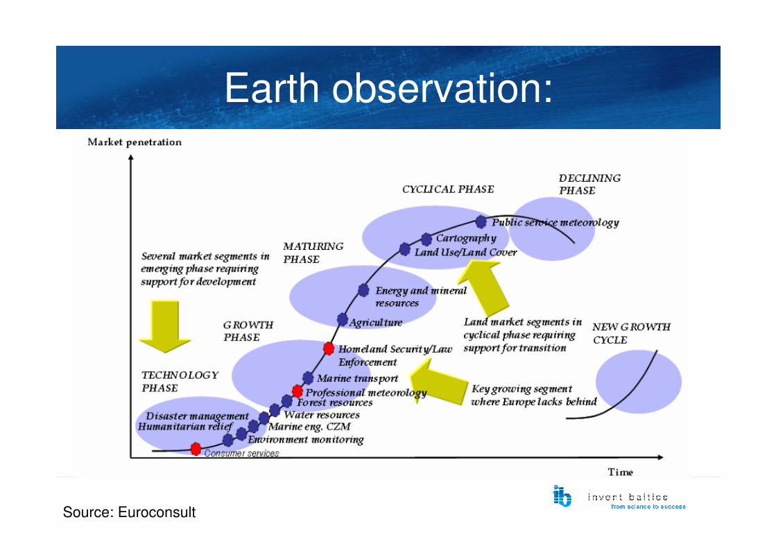
Earth observation:
• Most of the sub-markets are in growth or maturing phase
• In some segments double-digit growth (even over 30 % annually)
• Improved availability of high-resolution imagery from various sources
• In Europe – GMES initiative
Earth observation:
Source: Euroconsult
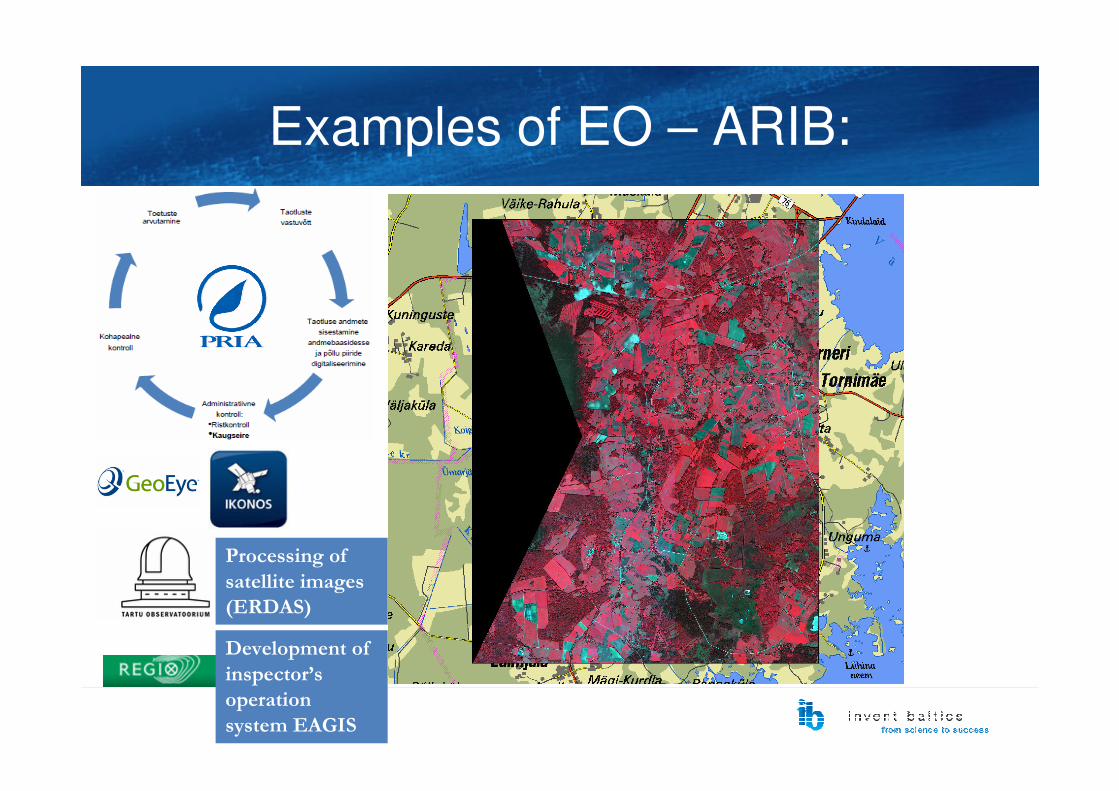
Examples of EO – ARIB:
Development of
inspector’s
operation
system EAGIS
Processing of
satellite images
(ERDAS)
Costs and benefits:
• Annually covered area – 4 satellite images,
each 13 km x 13 km = 676 km2 (free of charge;
EU central procurement)
• Data processing – contract with remote sensing
researchers in Tartu Observatory
• 3 remote sensing specialists in-house
• Measuring field areas 4-6 times cheaper using satellite imagery
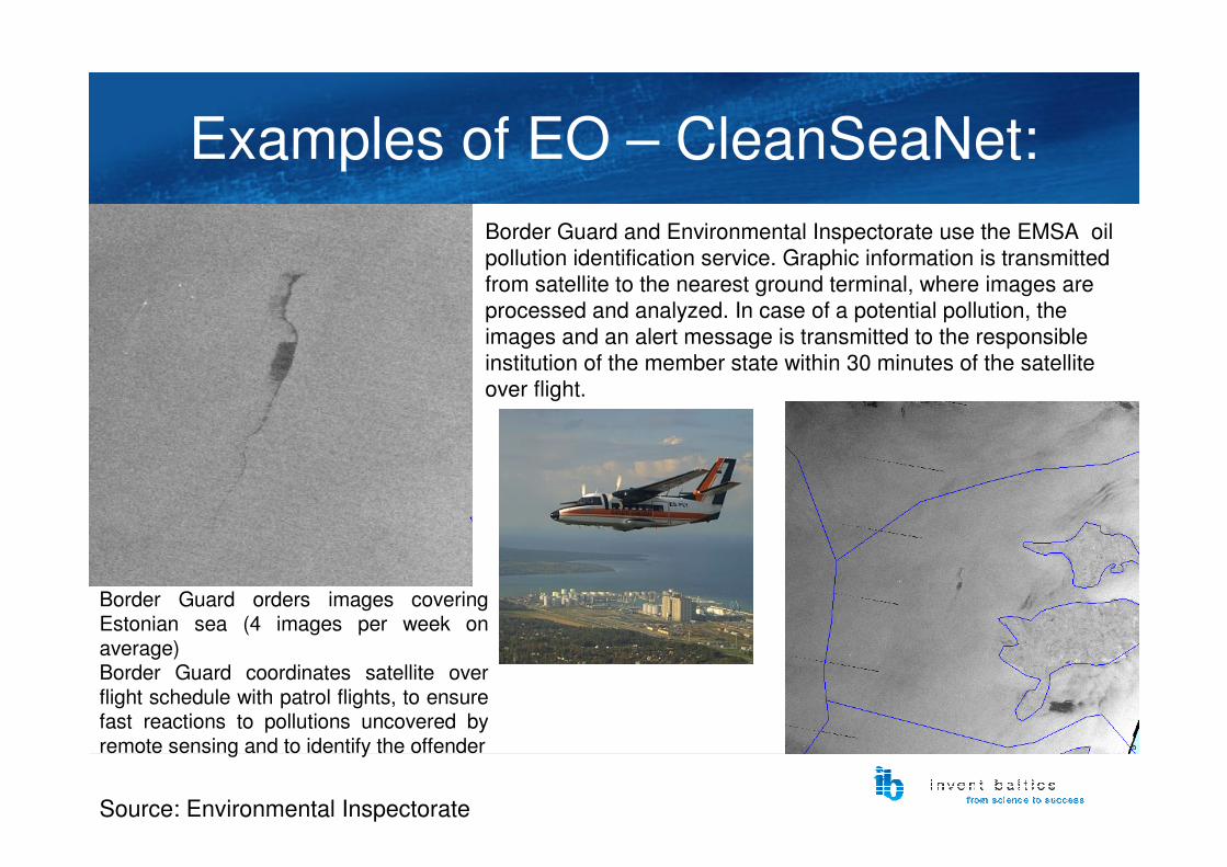
Examples of EO – CleanSeaNet:
Border Guard and Environmental Inspectorate use the EMSA oil
pollution identification service. Graphic information is transmitted
from satellite to the nearest ground terminal, where images are
processed and analyzed. In case of a potential pollution, the
images and an alert message is transmitted to the responsible
institution of the member state within 30 minutes of the satellite
over flight.
Border Guard orders images covering Estonian sea (4 images per week on average)Border Guard coordinates satellite over flight schedule with patrol flights, to ensure fast reactions to pollutions uncovered by remote sensing and to identify the offender
Source: Environmental Inspectorate
Impact of the service:
• Impact of remote sensing – intimidating potential
polluters, thus decreasing the probability of
pollution
• Pollution in the Baltic Sea – key eco-risk:
• Second level sea pollution – 10-50 tons of oil products
• Third level seal pollution – more than 50 tons of oil products
• Notorious “Alambra” accident (2000) – 250 tons of
crude oil, cleaning cost 4 million EEK

Common features of the
services:• Access to imagery and methodology – granted
on supranational level
• Value chain – end user or data processing level, limited value adding
• Cost-free imagery = strong (economic) benefits
EO System
Provider
EO System
Operator
Data
Distribution &
Archiving
Data
Processing
Marketing &
Product
Distribution
End User
Raw DataSystem Data Info Product
Downstream servicesUpstream
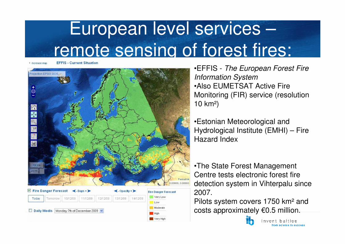
European level services –
remote sensing of forest fires:•EFFIS - The European Forest Fire
Information System
•Also EUMETSAT Active Fire
Monitoring (FIR) service (resolution
10 km²)
•Estonian Meteorological and
Hydrological Institute (EMHI) – Fire
Hazard Index
•The State Forest Management
Centre tests electronic forest fire
detection system in Vihterpalu since
2007.
Pilots system covers 1750 km² and
costs approximately €0.5 million.

Forest fires:
• Damages property – €1,200-12,000 per hectare
• Costs of rescue missions – large forest fires approximately €1 million
• Environmental damages
• in 2002 – nearly €1.8 million
• 2006 – nearly €1.1 million, 2 large fires of
1800 hectares
Problems with implementing
new public services:• Satellite imagery is considered to be expensive,
although this attitude rarely is backed with cost-
benefit calculations or long-run (strategical) view
• Some applications require reliable time series
and international compatibility
• Benefits are seldom monetary... but money sets
wheels in motion
• Variety of competing(?) technologies –airborne sensing, sensor networks etc
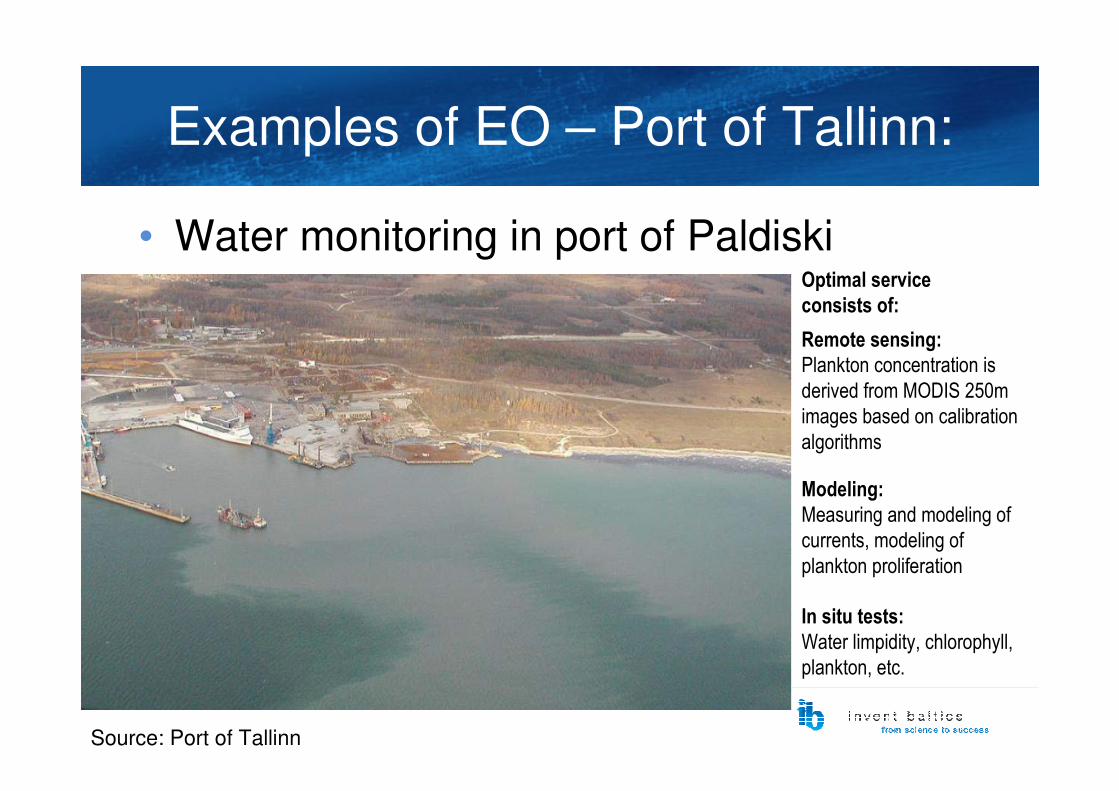
Examples of EO – Port of Tallinn:
• Water monitoring in port of Paldiski
Remote sensing:
Plankton concentration is
derived from MODIS 250m
images based on calibration
algorithms
Modeling:
Measuring and modeling of
currents, modeling of
plankton proliferation
In situ tests:
Water limpidity, chlorophyll,
plankton, etc.
Source: Port of Tallinn
Optimal service
consists of:
Satellite meteorology:
• EUMETSAT – established in 1986 for utilizing meteorological satellites
• July 2006 – EMHI started using EUMETCast services
• December 2006 - EMHI joined EUMETSAT
• Potential commercial users in private sector (TV channels, transport sector etc) already use Scandinavian services
• Estonia remains a net importer (end-user) of services in mature sub-markets of earth observation?
Future perspectives:
• Further development of existing services
• Satellite remote sensing needs to be considered for
environment monitoring and analysis of renewable
energy resources
• NB! access to dedicated R&D funding (so-called PECS projects) is crucial
• Unlocking existing scientific potential – more active
participation in GMES-related European R&D
projects in 2010-2013
Satellite navigation:
• Transport management – land-based, aviation, maritime
• Asset/vehicle tracking/management
• Location-Based Services (LBS)
• Precision farming, precision forestry
• Machine control
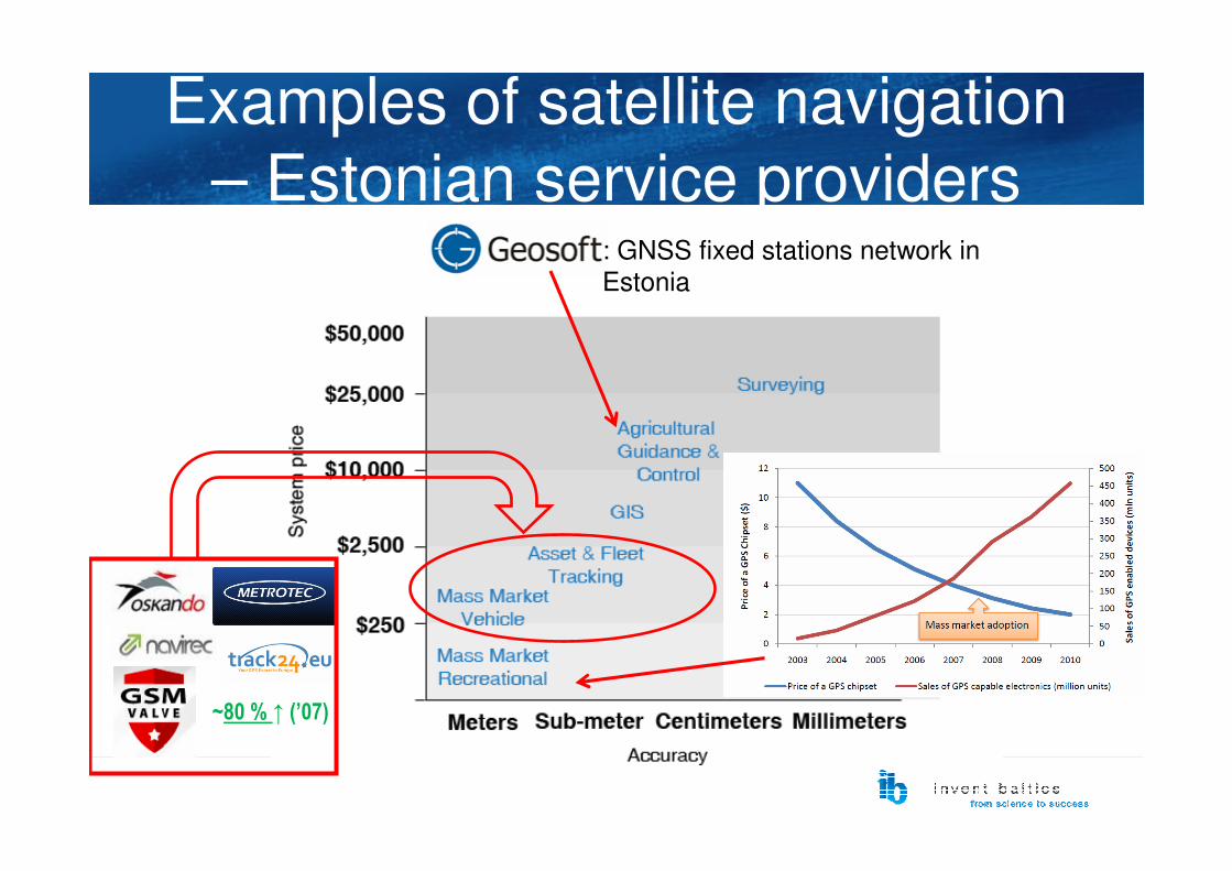
Examples of satellite navigation
– Estonian service providers
~80 % ↑ (’07)
: GNSS fixed stations network in
Estonia
Examples of satellite navigation
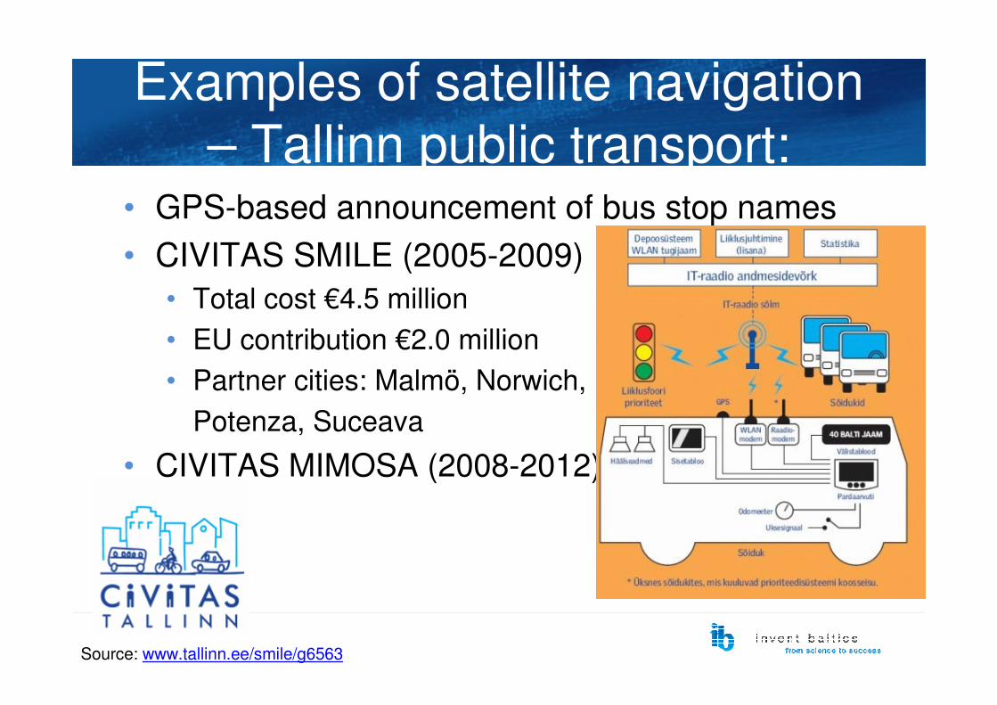
– Tallinn public transport:• GPS-based announcement of bus stop names
• CIVITAS SMILE (2005-2009)
• Total cost €4.5 million
• EU contribution €2.0 million
• Partner cities: Malmö, Norwich,
Potenza, Suceava
• CIVITAS MIMOSA (2008-2012)
Source: www.tallinn.ee/smile/g6563
Development of public services:
• Real-time information about public transport – low population density hinders economic benefits away from Tallinn or Tartu
• Supervision of implementation of public services (e.g. road maintenance) –institutional problems
• LBS services for applying in tourism sector
More distant future:
• eCall and GIS-112 – activities ongoing
• The feasibility of PAYD (pay-as-you-drive)
car insurance systems needs to be analyzed
• The feasibility of GPS/GSM-based electronic
traffic control system needs to be analyzed.
• Imposing a road tax??

Future services – precision
farming:In Estonia:
• Innovative thinking• Unstable prices of products
• Approximately ten active users
• More common to monitor machinery in
real time: engine
parameters, fuel
consumption etc.
Precision farming/forestry:
• Needs dedicated interdisciplinary research
• Coordinated collection and analysis of variety
of geoinfo both in-situ and from satellites
• Information thus analytical algorithms rather
country-specific � funding on national
level?
• Productivity gains – strong incentives for
adoption and emergence of market?

SWOT (public sector)Strengths Weaknesses
• Overall development of e-government
• Existing ground applications, demonstrating the feasibility of space technologies• Integration with international organization and pan-European initiatives (GMES, Galileo)• High level of satellite remote sensing research• Pro-activeness of entrepreneurs in developing downstream services
• Low and inconsistent financing (for instance in the environment monitoring domain)• Limited human resources for implementing the services• Unclarity about the national coordination of space sector• Low number of market mechanisms (for instance the international waste trade)• The relatively high cost of space technologies compared to alternatives (aero photography)• Low awareness about the possibilities• Overall economic structure
Opportunities Threats
• Access to international funding programmes and dedicated funding• Efficient national coordination• Undiscovered potential in several domains (environment monitoring, renewable energy, forestry, location-based services, public transport services)• The decreasing price of space technologies as a whole thanks to further development
• Technologies will be implemented only through international initiatives, becoming a late adopter• Legal obstacles for some services• Insufficient national funding• Insufficient integration with international organizations and initiatives• Research activities not in line with Estonian needs

Thank you for your attention!
Questions-comments?