Protected Bikeway Update to the Minneapolis Bicycle Master ...publicworks/documents/images… ·...
17
Protected Bikeway Update to the Minneapolis Bicycle Master Plan DRAFT April 17, 2015
Transcript of Protected Bikeway Update to the Minneapolis Bicycle Master ...publicworks/documents/images… ·...

Protected Bikeway Update to the Minneapolis Bicycle Master Plan
DRAFT
April 17, 2015

Protected Bikeway Update to the Minneapolis Bicycle Master Plan
DRAFT 4/17/2015 Page 1
What is a protected bikeway?
A protected bikeway is a bicycle facility that is physically separated from motor vehicle traffic. Off-street trails are the most common type of protected bikeway; however, protected bikeways may also be located within street corridors and separated from traffic lanes through parked cars, curbs, medians, bollards/flexible traffic posts, planters or other vertical feature. Protected bikeways are not the only tool in Minneapolis’ bikeway toolbox. Other bikeway facility types include bike lanes, shared lanes and bike boulevards. Why do we need protected bikeways?
Minneapolis is a great city for bicycling. The bicycle network has been expanded significantly in recent years, and a lot of people are biking. However, not everyone feels comfortable and safe riding on a busy street, even with a bike lane. There are some parts of the city where potential bicycling demand is high, but where low-stress bikeway facilities such as trails, bike boulevards, and lower-traffic streets are not an option. To continue to grow bicycling in Minneapolis, we need to make more of the city easier to bike for more people. Why do we need to update the plan?
The current Minneapolis Bicycle Master Plan, adopted in 2011, addresses a broad range of bikeway facility types, including off-street trails, bike boulevards, bike lanes, and shared lanes, but it does not specifically address on-street protected bikeways. The City of Minneapolis also approved a Climate Action Plan in 2013 recommending implementation of 30 miles of on-street protected bike facilities by 2020. What is the scope of the plan update?
This plan update identifies priority locations for near-term implementation of protected bikeways in Minneapolis. The plan update focuses on near-term priorities, not a long-term vision, for protected bikeways. The majority of recommended protected bikeways are located in downtown or connecting to downtown where bicycle demand is high and there are few low-stress bikeway options, such as trails, bike boulevards, or quiet residential streets. This plan update does not address non-protected bikeways in the existing 2011 Bicycle Master Plan.
Protected bikeways can extend the experience of biking on a trail to busy city destinations where low-stress bikeway options like trails, bike boulevards, or low-traffic streets aren’t an option.
Minneapolis Bikeway Network Development
Bikeway Type Centerline Miles by Year
1997 2010 2014 This Plan
Long-Term*
Protected Bikeways 62 89 96 144 174
Bike Lanes 19 44 82 50 104
Shared Lanes 1 5 15 11 74
Bike Boulevards 20 20 44
To Be Determined 6 6
Total 82 138 213 232 403
* Based on existing network, this plan, 2011 Bicycle Master Plan, and other recent planning activities.
Minneapolis Bikeway Facility Types
Protected bikeways are one of four categories of bikeways used in Minneapolis.
Cre
dit
: Peo
ple
fo
r B
ikes
Protected Bikeway Update to the Minneapolis Bicycle Master Plan
DRAFT 4/17/2015 Page 2
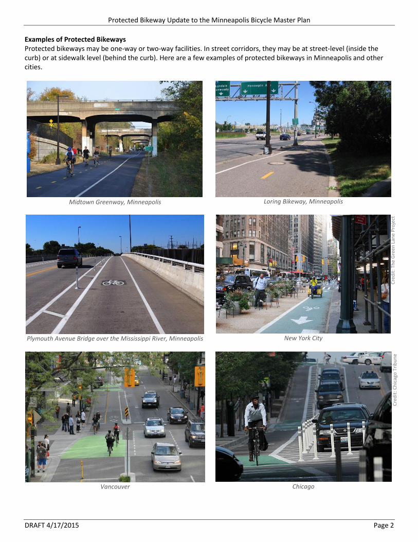
Examples of Protected Bikeways Protected bikeways may be one-way or two-way facilities. In street corridors, they may be at street-level (inside the curb) or at sidewalk level (behind the curb). Here are a few examples of protected bikeways in Minneapolis and other cities.
Midtown Greenway, Minneapolis
Loring Bikeway, Minneapolis
Plymouth Avenue Bridge over the Mississippi River, Minneapolis
New York City
Vancouver
Chicago
Cre
dit
: Th
e G
reen
Lan
e P
roje
ct
Cre
dit
: Ch
icag
o T
rib
un
e

Protected Bikeway Update to the Minneapolis Bicycle Master Plan
DRAFT 4/17/2015 Page 3
Evaluation and Engagement Process The draft plan update is the result of a year-long planning process, beginning with a public open house and online survey in spring 2014 that sought input on locations where protected bikeways are most needed. City staff used the public input to identify locations where protected bikeways should be evaluated, while also considering areas with high bicycle demand, high traffic conflict and good network integration. Staff worked with the Bicycle Advisory Committee to identify 19 corridors for further evaluation. 17 of the identified 19 corridors were further evaluated by a team of Minneapolis Public Works and Hennepin County staff. The feasibility of implementing protected bikeways was difficult to determine in some segments due to challenging tradeoffs with existing curb-side uses. This includes significant portions of two downtown corridors (Hennepin Ave S/1st Ave N and 5th/6th Streets S); these segments are identified as bikeway facility type “to be determined.” The appendix contains the results of this feasibility analysis, including a preliminary design concept for each corridor. The appendix also includes cost estimates based on a protected bikeway design with flexible delineator posts. Costs could be higher based on different design scenarios. The recommended near-term protected bikeway projects in this plan update include the results of this planning process as well as protected bikeways that were already programmed for implementation in 2015 or later. Similar to the current Minneapolis Bicycle Master Plan, it is important to note that this plan update is guidance for the design process. Community input and technical factors may result in a different design. As opportunities to implement protected bikeways arise, engagement plans will be developed for each project based on the context of the corridor, including type of opportunity (e.g. street resurfacing, street reconstruction), level of technical challenges and the range of stakeholders. The draft plan was reviewed by the Bicycle Advisory Committee, as well as staff from Hennepin County, MnDOT, MPRB, and Metro Transit prior to being released for public review and comment in spring 2015.

Protected Bikeway Update to the Minneapolis Bicycle Master Plan
DRAFT 4/17/2015 Page 4
Priority Near-Term Protected Bikeway Projects Tables 1-3 and Figures 1-4 show the corridors recommended for near-term protected bikeway implementation with the intent of meeting or exceeding the Climate Action Plan’s goal of 30 miles of on-street protected bicycle facilities by 2020. These corridors total more than 50 miles, including over 30 miles on corridors where there is an existing bicycle facility. A significant focus of this plan update is to upgrade the quality of existing bicycle facilities in busy traffic corridors where there alternative low-stress routes are limited. The costs shown are high-level estimates and will require further refinement. The low end of the cost range represents the estimated cost of removal and installation of all pavement markings, signs, delineators, traffic control, mobilization and construction elements, while the high end of the cost range represents estimated additional costs of traffic signals and pavement seal coating, which may not be necessary for all projects; both figures include a 25% contingency. Cost estimates for projects that are already funded are not included. An approximate phasing is shown in three tiers relative to the complexity of project delivery, funding opportunities, and coordination with other infrastructure projects. This phasing is intended to be flexible and used as an implementation guide, not a strict program of projects.
Tier 1 includes 15 miles of corridors, including 7 miles with no existing bicycle facility. These projects are the nearest-term opportunities for implementation of protected bikeways, and many are already funded. Between $3.0 million and $4.3 million in additional funds will be needed to implement these projects, excluding projects that are already funded. See Table 1 and Figure 1.
Tier 2 includes 28 miles of corridors, including 9 miles with no existing bicycle facility. These projects are either more complex to implement or have funding identified in later years than the Tier 1 projects. Between $4.2 million and $7.8 million in additional funds will be needed to implement these projects, excluding projects that are already funded. See Table 2 and Figure 2.
Tier 3 includes 11 miles of corridors, primarily with existing bicycle facilities. These projects are either lower priority or require further evaluation to determine feasibility. See Table 3 and Figure 3.
In addition to these corridors, several corridors were evaluated for protected bikeway feasibility and are recommended for shared lanes, standard bike lanes or buffered bike lanes, instead of protected bike lanes. See Table 4 and Figure 5. The existing network, recommended protected bikeway projects, existing with recommended protected bikeway projects, and long-term network maps are shown in Figures 6-8.
Minneapolis Bikeway Network Development – Centerline Miles
Bikeway Type Network Development to Date
Existing Network with Protected Bikeways in this Plan (Tables 1-3)
Long-Term Network*
1997 2010 2014 Tier 1 Tier 2 Tier 3
Protected Bikeways 62 89 96 111 136 144 174 Bike Lanes 19 44 82 76 59 50 104 Shared Lanes 1 5 15 13 13 13 74 Bike Boulevards 20 20 20 20 44 To Be Determined 2 6 6
Total 82 138 213 220 230 232 403
* Based on the existing network, Tables 1-4 in this plan update, the 2011 Bicycle Master Plan, and other recent planning activities.

Protected Bikeway Update to the Minneapolis Bicycle Master Plan
DRAFT 4/17/2015 Page 5
Table 1: Tier 1 Protected Bikeway Implementation Opportunities ID Location Mileage &
Directions Estimated
Unfunded Cost in $1000s*
Implementation Considerations
2B Franklin (29th
Ave S to Seabury Ave S) 0.3 (2-way) $110-185 Resurfaced in 2011; coordinate with #23 river bridge and future 29
th Ave bike boulevard
11B 10th
St S (1st
Ave N to Park Ave S) 0.8 (1-way) $195-420 Coordinate with #11C; seal coated in 2012/13
11C 9th
St S (1st
Av N to Park Ave S) 0.9 (1-way) $145-350 2015 resurfacing project (City)
12B Oak St SE (E River Pkwy to Washington Ave SE)
0.3 (2-way) $45-110 Seal coated in 2014
16A Plymouth Ave N / 8th
St NE (Fremont to 5
th St NE)
1.9 (2-way) $320-570 5-block segment west of Lyndale Ave to be resurfaced in 2018; small segment of bike blvd on eastern end
18A 3rd
Ave S (Washington Ave to University Ave SE)
0.7 (2-way) $200-375 Coordinate with #18B 3rd
Ave S and MnDOT bridge rehabilitation (2020-2021)
18B 3rd
Ave S (16th
St E to Washington Ave S) 1.0 (2-way) $1,580 Requires removal of center medians and left turn lanes; 2016 seal coating candidate
19A Washington Ave (5th
Ave S to 19th
Ave S) 0.9 (2-way) $245-525 Coordinate with #22 Washington reconstruction/cycletrack; a bike lane is currently proposed for 2015 installation; protected bikeway not feasible on I-35W bridge without widening
20A 26th
& 28th
St (Portland to Hiawatha) 2.5 (1-way) partially funded ($160 needed)
2015 resurfacing project (City)
21 26th
Ave N (Wirth Pkwy to River) 2.0 (2-way) funded 2015-16 project (City)
22 Washington Ave S (Hennepin to 5th
Av S) 0.4 (2-way) funded 2015 project (County)
23 Franklin Ave (river crossing) 0.2 (2-way) funded 2015 project (County)
24 Intercity Trail 1.0 (2-way) funded 2015 project (Three Rivers/City/MPRB)
25 Broadway St NE (Stinson Blvd NE to Industrial Blvd NE)
0.8 (2-way) funded 2015 project; potential 2018-19 reconstruction (federal application submitted)
31 Mississippi River East Bank Trail 0.9 (2-way) funded 2015 project (Park Board)
32 5th
/6th
Street Trails (Vikings Stadium) 0.4 (1 & 2-way)
funded Vikings Stadium project
33 Ridgway Parkway Trail 0.8 (2-way) funded 2015 project (Park Board)
34 Bryn Mawr Trail 0.7 (2-way) funded 2015 project (Park Board)
Total Tier 1 16 miles $3.0-4.3 million
Low end of cost range excludes the cost of seal coating and signal improvements, which may not be necessary for all projects.

Protected Bikeway Update to the Minneapolis Bicycle Master Plan
DRAFT 4/17/2015 Page 6
Figure 1: Tier 1 Protected Bikeway Implementation Opportunities
Bikeway Type Existing Mileage
Recommended Mileage
Protected Bikeways <1 15 Bike Lanes 6 <1 Shared Lanes 2 Bike Boulevards <1 To Be Determined
Total 8 15

Protected Bikeway Update to the Minneapolis Bicycle Master Plan
DRAFT 4/17/2015 Page 7
Table 2: Tier 2 Protected Bikeway Implementation Opportunities ID Location Mileage &
Directions Estimated Unfunded
Cost in $1000s*
Implementation Considerations
6A/ 5D
Hennepin/1st
Ave NE (Washington Ave to 5
th St NE)
1.7 (1 and 2-way)
$550-740 Coordinate with NE Traffic Study and Nicollet-Central Modern Streetcar
5A Dunwoody Blvd Trail (Van White Blvd to Hennepin Ave)
0.4 (2-way) $310-315 Coordinate with SWLRT sidewalk improvements (2018-2019)
5B Hennepin Ave (Maple St to 12th
St) 0.3 (2-way) $20 Coordinate with #5A Dunwoody Blvd Trail
7A Grant St (Willow St to 2nd
Ave S) 0.5 (2-way) $90-140 Coordinate with #7B Marquette/2nd
& #9A 1st
/Blaisdell
8B Park/Portland (West River Pkwy to Franklin)
2.5 (1-way) $365-910 Standard bike lanes north of Washington Ave S
9A 1st
/Blaisdell Ave S (Grant St to 40th
St) 5.4 (1-way) $550-1,400 Several segments need further evaluation to determine whether a protected bikeway is feasible. 1
st Ave S (Lake to
12th
) is a 2017 resurfacing project; coordinate with Nicollet-Central Modern Streetcar
10B 11th
Ave S (6th
St S to West River Pkwy) 0.5 (2-way) $95-165 Implement after 5th
St I-94 is relocated to 7th
St in 2016
11A 7th
St N (Plymouth Ave to 1st
Ave N) 1.7 (2-way) funded SWLRT project (2018-2019)
11B 10th
St S (1st
Ave N to Park Ave S) 0.8 (1-way) $195-420 Coordinate with #11C; seal coated in 2012/13
11C 9th
St S (1st
Av N to Park Ave S) 0.9 (1-way) $145-350 2015 resurfacing project (City)
12A University Ave SE (1st
Ave NE to Oak St SE) 1.8 (2-way) $585-920 MnDOT street resurfacing (Central Ave to I-35W) 2018-19
12C Oak St SE (Washington Ave to Walnut St) 0.3 (2-way) $300-375 Complex multimodal intersection
13A-C
15th
Ave SE to NE Diagonal (University Ave SE to Hennepin Ave E)
1.1 (2-way) $475-665 Potential 2018-19 implementation (federal application submitted “U of M Protected Bikeways”); northern two blocks require further evaluation for a protected bikeway
14 A-B
10th
Ave SE/19th
Ave SE/20th
Ave S (5th
St SE to Riverside Ave)
1.5 (2-way) $275-490 Potential 2018-19 implementation (federal application submitted “U of M Protected Bikeways”); coordinate with 10
th Ave Bridge rehabilitation
15
Emerson/Fremont Ave N (Plymouth to 33rd
Ave N) – 1-way on Emerson and Fremont or 2-way on Emerson
3.2 (1-way) or
1.6 (2-way)
$270-685 (1-way) or $175-395 (2-way)
Potential 2018-19 implementation (federal application submitted); coordinate with arterial BRT (2018-19) and Emerson Ave resurfacing (Plymouth to West Broadway - 2017)
17B Marshall St NE (14th
to Lowry) 0.8 (2-way) $90-215 Coordinate with East Bank Trail projects; cost estimate assumes protected bikeway within existing curb lines; off-street trail would cost more. Evaluate potential extension to 27
th Ave NE or St Anthony Pkwy
20B 26th
& 28th
St (Hennepin to Portland) 2.9 (1-way) TBD Coordinate with reconstruction of I-35W bridges (2017-2019)
27 Van White Blvd Trail Gap 0.2 (2-way) funded SWLRT project (2018-2019)
28 18th
Ave NE (Monroe St NE to Ulysses St NE)
0.8 (2-way) funded 2018 project (City)
29 Hiawatha Trail Gap 0.6 (2-way) funded 2018 project (City)
30 5th
St S/I-94 Ramp (Hiawatha Trail to 11th
Ave S)
0.4 (2-way) funded 2017-2018 project (City)
35 11th
Ave S/12th
Ave S (Midtown Greenway to 28
th St E)
0.3 (2-way) funded 2017-2018 Safe Routes to School Project at Andersen School (City)
Total Tier 2 29 miles $4.2-7.8 million
Low end of cost range excludes the cost of seal coating and signal improvements, which may not be necessary for all projects.

Protected Bikeway Update to the Minneapolis Bicycle Master Plan
DRAFT 4/17/2015 Page 8
Figure 2: Tier 2 Protected Bikeway Implementation Opportunities
Bikeway Type Existing Mileage
Recommended Mileage
Protected Bikeways 25 Bike Lanes 18 <1 Shared Lanes 1 Bike Boulevards <1 To Be Determined 2
Total 19 28

Protected Bikeway Update to the Minneapolis Bicycle Master Plan
DRAFT 4/17/2015 Page 9
Table 3: Tier 3 Protected Bikeway Implementation Opportunities ID Location Mileage &
Directions Estimated Unfunded
Cost in $1000s*
Implementation Considerations
4A Lyndale Ave S (Franklin Ave to Loring Greenway Bridge)
0.1 (2-way) $935-1,060 Need to determine logical connection at southern end.
4B Sculpture Garden Sidepath (Dunwoody to Vineland)
0.2 (2-way) $60 Scope of Hennepin/Lyndale project and Sculpture Garden projects (2015-16) do not include installation of a new trail; pinch point at footings of pedestrian bridge.
8A/8C Park and Portland (Minnehaha Parkway to Franklin)
7.0 (1-way) $725-1,845 Buffered bike lanes recently installed. Lower priority than #8B.
17A Main/Marshall (Hennepin to 14th
Ave NE)
1.2 (2-way) $165-385 Existing bike lanes; parallel river trail. Lower priority than #17B.
5C or 5E
1st
Ave N or Hennepin Ave S (12th
to Washington)
0.9 (2-way) TBD Existing protected bike lanes on 1st
Ave N have lower use than shared bike/traffic lanes on Hennepin Ave S. Further feasibility evaluation needed. Protected bike lanes on Hennepin Ave S would require extensive street reconstruction. Removal of protected bike lanes on 1
st Ave
N could support future street narrowing and sidewalk widening.
10A & 10C
5th
and/or 6th
St S (Hennepin to Chicago) 1.6 (1-way) TBD Important east-west connection through downtown; further feasibility evaluation needed
Total Tier 3 11 miles TBD
Low end of cost range excludes the cost of seal coating and signal improvements, which may not be necessary for all projects.
Table 4: Corridors Evaluated and Recommended for Non-Protected Bikeways ID Location Evaluation Conclusions
1A 24th
St (Hennepin Ave to Hiawatha Ave) Standard bike lanes are feasible and appropriate for the lower-volume traffic conditions on 24th St. Maintain existing bike lanes east of I-35W and add bike lanes west of I-35W (may require parking removal or some shared lane segments).
1B Franklin Ave (Hennepin Ave to Bloomington Ave)
Protected bike lanes are not feasible. Standard bike lanes are recommended, consistent with the 2011 Bicycle Master Plan. Further evaluation will be needed.
2A Franklin Ave E (Bloomington to 20th
) A buffered bike lane is recommended. Protected bike lanes are feasible in the existing condition; however, additional parking is planned along the median in conjunction with a pedestrian plaza recently constructed.
2C Franklin Ave (20th
Ave S to 29th
Ave S) Maintain existing bike lanes and on-street parking.
3A Franklin Ave SE (East River Pkwy to Emerald St SE)
Standard bike lanes are recommended. Street is too narrow for a protected bikeway, even with parking removal.
4C Hennepin Ave S (Oak Grove to Maple St) Northbound buffered bike lane will be added in conjunction with 2015-16 Hennepin/Lyndale project. Parallel trail through Loring Park.
6B 5th
St NE (Hennepin Ave to 3rd
Ave NE) Maintain/improve existing bike lanes.
7B Marquette/2
nd Ave S (1
st Ave S to
Washington) Protected bike lanes are not feasible. Protected bikeway planned for #18B 3
rd Ave S, where
there is higher bicycle demand and greater network connectivity.
12D 4th
St SE (1st
Ave NE to Walnut St SE) Maintain and fill gaps in existing bike lane. Two-way protected bikeway planned for #12A University Ave SE.
13D 15th
Ave SE/Como Ave SE (Rollins Ave SE to 18
th Ave SE)
Maintain existing bike lanes. Alternative route to #13B.

Protected Bikeway Update to the Minneapolis Bicycle Master Plan
DRAFT 4/17/2015 Page 10
Figure 3: Tier 3 Protected Bikeway Implementation Opportunities
Bikeway Type Existing Mileage
Recommended Mileage
Protected Bikeways <1 8 Bike Lanes 9 <1 Shared Lanes <1 Bike Boulevards To Be Determined 4
Total 10 12

Protected Bikeway Update to the Minneapolis Bicycle Master Plan
DRAFT 4/17/2015 Page 11
Figure 4: Recommended Near-Term Protected Bikeway Projects (Tiers 1-3)
Bikeway Type Existing Mileage
Recommended Mileage
Protected Bikeways 1 48 Bike Lanes 33 1 Shared Lanes 3 Bike Boulevards
To Be Determined 6
Total 37 55

Protected Bikeway Update to the Minneapolis Bicycle Master Plan
DRAFT 4/17/2015 Page 12
Figure 5: Corridors Evaluated and Recommended for Non-Protected Bikeways
Bikeway Type Existing Mileage
Recommended Mileage
Protected Bikeways Bike Lanes 4 8 Shared Lanes 2 2 Bike Boulevards To Be Determined
Total 6 10

Protected Bikeway Update to the Minneapolis Bicycle Master Plan
DRAFT 4/17/2015 Page 13
Maintenance Considerations
In recent years, the bikeway network has been expanded significantly from 82 miles in 1997 to 213 miles in 2014 with virtually no increase in annual maintenance budgets. In order to successfully implement protected bikeways in Minneapolis, additional maintenance resources will be needed. Not only is the bikeway network mileage recommended for expansion, but protected bikeways cost more to maintain than existing maintenance practices for bike lanes.
Based on the experience of the City of Minneapolis’ Transportation Maintenance and Repair Division in maintaining the existing bikeway network, the average costs to maintain different types of bikeways are shown in Table 5, and the estimated maintenance costs of the protected bikeways recommended in this plan are shown in Table 6.
The unit costs for protected bikeways are based on limited experience primarily with the 1st Avenue N protected bike lanes. It is anticipated that as the protected bikeway network grows, there will be economies of scale to be gained; however, these are difficult to forecast with limited experience and are not assumed in these estimates. These estimates do not account for the costs of maintaining the existing system, nor do they account for the incremental change in costs between the existing system, enhanced maintenance of the existing system, and the recommended protected bikeway projects. These are conservative estimates based upon the best information available today and will need to be refined as the City of Minneapolis gains more experience with maintaining protected bikeways.
Table 5: Average Bikeway Maintenance Unit Costs
Bikeway Facility Type Maintenance Practice Annual Cost per
Linear Foot
Trail Clear Snow & Sweep Weekly $2.00/LF
Bike lane with enhanced sweeping (per direction) Clear Snow & Sweep Weekly $1.00/LF
Bike lane with enhanced year-round maintenance (per direction)
Remove Snow & Sweep Weekly $3.75/LF
One-way protected bike lane (per direction) Remove Snow & Sweep Weekly $6.50/LF
Two-way protected bike lane on one side Remove Snow & Sweep Weekly $10.00/LF
Source: Minneapolis Public Works Transportation Maintenance and Repair Division
Table 6: Estimated Annual Maintenance Costs of Plan Recommendations
Bikeway Facility Type Cost per
Foot Cost per
Mile
Tier 1 Tier 2 Tier 3 Total
Miles Cost Miles Cost Miles Cost
Trail $2.00 $10,560 6.0 $64,000 2.7 $29,000 0.2 $2,000 $95,000
One-way protected bike lane (single direction)
$6.50 $34,320 2.5 $86,000 13.7 $471,000 6.5 $222,000 $779,000
One-way protected bike lane (two directions)
$13.00 $68,640 4.9 $335,000 6.7 $457,000 1.7 $114,000 $906,000
Two-way protected bike lane on one side
$10.00 $52,800 1.1 $59,000 4.7 $247,000 2.8 $149,000 $455,000
Total
15 $544,000 28 $1,204,000 11 $487,000 $2,235,000
This includes all recommended protected bikeways in this plan regardless of ownership (City, County, MnDOT, MPRB) and regardless of existing capital funding status (includes both new and already-funded projects). MPRB trail projects are in Tier 1 and total 3.4 miles and an estimated $34,000 in annual maintenance costs. For cost estimating purposes, two-way protected bikeways on one side of the street are assumed for Loring Bikeway Southern Extension (4A), Grant St (7A), 5
th or 6
th St S (10A & 10C), Oak St
SE (12A & 12 B), University Ave SE (12C), 18th
Ave SE (13C), 10th
/19th
Ave SE (14B), Marshall/Main St NE (17A & 17B), and Broadway St NE (25).

Protected Bikeway Update to the Minneapolis Bicycle Master Plan
DRAFT 4/17/2015 Page 14
Figure 6: Existing Bicycle Network
Bikeway Type Mileage
Protected Bikeways 96
Bike Lanes 82
Shared Lanes 15
Bike Boulevards 20
To Be Determined
Total 213

Protected Bikeway Update to the Minneapolis Bicycle Master Plan
DRAFT 4/17/2015 Page 15
Figure 7: Existing Bicycle Network with Priority Protected Bikeways
Bikeway Type Mileage
Protected Bikeways 142 Bike Lanes 50 Shared Lanes 13 Bike Boulevards 20 To Be Determined 6
Total 232

Protected Bikeway Update to the Minneapolis Bicycle Master Plan
DRAFT 4/17/2015 Page 16
Figure 8: Planned Long-Term Bicycle Network
Based on the existing network, Tables 1-4 in this plan update, the 2011 Bicycle Master Plan, and other recent planning activities.
Bikeway Type Mileage
Protected Bikeways 172 Bike Lanes 104 Shared Lanes 76 Bike Boulevards 44 To Be Determined 6
Total 403