Protected Areas Gap Analysis Version 2
40
1 PROTECTED AREA REPRESENTATION GAP ANALYSIS Spray Lake Sawmills FMA/B9 Areas Prepared for: Spray Lake Sawmills (1980) Ltd. Cochrane, Alberta Prepared by: John L. Kansas, M.Sc., P.Biol. HAB-TECH Environmental Ltd. and Jason Mogilefsky, B.Sc., RPF Spray Lake Sawmills July, 2013
Transcript of Protected Areas Gap Analysis Version 2
1
PROTECTED AREA REPRESENTATION GAP ANALYSIS
Spray Lake Sawmills FMA/B9 Areas
Prepared for:
Spray Lake Sawmills (1980) Ltd.
Cochrane, Alberta
Prepared by:
John L. Kansas, M.Sc., P.Biol.
HAB-TECH Environmental Ltd.
and
Jason Mogilefsky, B.Sc., RPF
Spray Lake Sawmills
July, 2013
2
EXECUTIVE SUMMARY
This report presents a protected area gap analysis for the Spray Lake Sawmills FMA/B9 Quota
area, as required for Forest Stewardship Council (FSC) certification. The analysis follows
standard approaches for representation gap analysis used by the Secretariat for the Convention
on Biological Diversity (CBD) and World Wildlife Fund. The approach compares the
distribution of key biodiversity areas with the distribution of protected areas as a means of
finding where important elements of biodiversity (i.e. habitat, ecosystems) remain unprotected or
under-protected. Alberta Natural Subregions were used as a coarse-filter surrogate for
landscape, community and species-level biodiversity in the SLS FMA/B9 Quota area. Alberta
government targets for province-wide Natural Subregion protection are significantly lower than
current standards for protected areas. SLS has adopted a 12% protection level proportionate to
the occurrence of these subregions in the FMA.
The FMA comprises portions of five Natural Subregions - Montane, Lower Foothills, Upper
Foothills, Subalpine and Alpine. Lower elevation lands in the Montane and Lower Foothills
subregions support disproportionately higher levels of vegetation composition, structure and
vertebrate wildlife diversity than do the Upper Foothills, Subalpine and Alpine natural regions.
Furthering protection of low elevation habitats in the FMA is a primary goal of this gap analysis.
Thirty-seven percent of the RRA is currently comprised of formally protected areas, including
Wildland Provincial Parks (WPP) and Provincial Parks (PP) (Don Getty WPP, Elbow-Sheep
WPP, Bluerock WPP, Sheep River PP), which occur immediately adjacent to and functionally
within the FMA. More than 188 km2 of currently protected lands were former timber quota
lands, voluntarily contributed by SLS to the Crown for the purpose of protecting lower elevation
Foothills landscapes. Protected areas (including candidate conservation management areas from
the South Saskatchewan River Basin planning process) are abundant in the FMA and region for
the Alpine, Subalpine and Montane subregions. Provincial and 12% SLS targets for these three
subregions have been met or exceeded. No further protected areas are recommended for these
subregions in the SLS FMA/B9 Quota area.
Protected areas within the Foothills Natural Region are under-represented in the SLS FMA and
regional environs. SLS will utilize three potential sources to fill protected areas gaps:
1) The Red Deer River ESA, for formal protection. The Red Deer River portion of
nationally significant ESA #20 occurs in the northern portion of the FMA and crosses
mainly Lower Foothills lands, with some Upper Foothills. This ESA (or portions thereof)
offers strong potential as a protected areas candidate for Foothills habitats in the FMA.
SLS will collaborate with interested parties and stakeholders through the formal
protection process, outlined in this paper.
2) The passive landbase areas designed to meet specific ecological objectives and serve as
permanent reserves. Portions of the passive and active landbase will be designed with
stakeholders to contribute to a protected area network beyond the management unit.
3) South Saskatchewan Regional Planning Candidate Conservation Management Areas
having ecological integrity serving as formal or informal protected areas. The SSRP is a
government led process and the draft plan is due for public release, the fall of 2013.

3
SLS will collaborate with interested parties to assess the Foothills Natural Region gaps and
initiate a collaborative process to fill gaps from both the Red Deer River ESA and the passive
landbase sources. This process of collaboration will be open to all interested parties including:
First Nations, government, commercial interests, disposition holders, ENGO stakeholders and
the public.
4
ACKNOWLEDGMENTS
Ed Kulcsar, Woodlands Manager for Spray Lake Sawmills provided ideas, guidance and
research. Glen Dunsworth offered sage advice on FSC requirements. Laurie Kremsater
conducted an independent peer review of the draft report. Kim McNeil and Dwight Crouse of
Tesera Systems Inc., Matt Denney and Jordan Dyck of Spray Lake Sawmills conducted GIS
mapping. Thanks to all!

5
TABLE OF CONTENTS
1.0 INTRODUCTION 6
2.0 PROTECTED AREA GAP ANALYSIS - CONCEPTS/APPROACHES 7
3.0 HISTORY OF GAP ANALYSIS IN THE SLS FMA/B9 REGION 8
3.1 Province of Alberta Protected Areas Approach 8
3.2 SLS Participation in Special Places 2000 8
3.3 South Saskatchewan Regional Plan CCMA’S 9
4.0 CURRENT GAP ANALYSIS FOR SLS FMA/B9 REGION 10
4.1 Step #1: Gap Analysis and Scope 10
4.2 Step #2: Identification of Focal Biodiversity Targets 13
4.3 Step #3: Evaluation and Mapping of Biological Diversity 13
4.4 Step #4: Existing Occurrence/Status of Protected Areas 16
4.5 Step #5: Protected Area Gap Identification 16
4.6 Step #6: Gap Prioritization 23
4.7 Step #7: Strategy for Filling Protected Area Gaps in FMA 33
5.0 SUMMARY AND CONCLUSIONS 35
5.1 Protected Area Gap Analysis Summary 35
5.2 Protected Area Gap Analysis Conclusions 36
6.0 LITERATURE CITED 38
FIGURES
Figure 1. Spray Lake Sawmills Ltd. Forest Management Area. 11
Figure 2. Regional Gap Analysis Area and Natural Subregions. 12
Figure 3. Species Rich and Uncommon Habitat Types in the FMA-North. 14
Figure 4. Species Rich and Uncommon Habitat Types in the FMA-South. 15
Figure 5. Protected Areas Within and Adjacent to the SLS FMA/B9 Quota. 17
Figure 6. Candidate Conservation Management Area #8 - SSRB Plan 21
Figure 7. Candidate Conservation Management Area #9 - SSRB Plan 22
Figure 8. Multi-species Habitat Ratings - Sheep River/Bluerock areas and Region. 25
Figure 9. Environmentally Significant Areas in the SLS FMA and Region. 27
Figure 10. Species Rich and Uncommon Habitats in Red Deer River ESA 28
Figure 11. Passive Landbase in the Northern Portion of the SLS FMA 30
Figure 12. Passive Landbase in the Southern Portion of the SLS FMA 31
TABLES
Table 1. Protected Area Coverage and Targets - Alberta and SLS FMA 18
Table 2. Unique/Species Rich Habitat Types in Passive vs. Active Landbase 32
6
1.0 INTRODUCTION
1.1 Background
Spray Lake Sawmills (1980) Ltd. (SLS) is pursuing Forest Stewardship Council (FSC) forest
management certification for the SLS Forest Management Agreement Area (FMA) and B9
Quota area. SLS is currently being audited to FSC's National Boreal Standard (FSC Canada
2004). In May 2012 an independent FSC accredited certification body submitted a Forest
Management Certification Assessment report (Rainforest Alliance - SmartWood 2012). The
report presented an evaluation of the ecological, economic and social performance of Spray Lake
Sawmills Ltd. as defined by the Forest Stewardship Council. Discrepancies or gaps were
identified between some aspects of SLS's management system and the requirements of the forest
stewardship standard, resulting in non-conformance reports (NCR). The assessment team
differentiated between major and minor non conformances depending on the severity of the non-
conformance. Major non conformances must be corrected before the certificate can be issued.
Minor non-conformances do not prohibit issuing the certificate, but they must be addressed
within the given timeframe to maintain the certificate.
Principle 6 (Environmental Impact) of FSC's National Boreal Standard calls for forest
management that conserves biological diversity and its associated values. Criteria 6.4 of
Principle 6 requires the applicant ".....to protect representative samples of existing ecosystems
within the landscape in their natural state and to record these ecosystems on maps, appropriate
to the scale and intensity of operations and the uniqueness of the affected resources" (FSC
Canada 2004). Indicator 6.4.1 of Criteria 6.4 requires that ".....the applicant completes (or makes
use of) a peer-reviewed gap analysis to address the need for protected areas in the eco-region(s)
and ecodistrict(s) in which the forest is situated". A major NCR (04/12) was issued to SLS
pertaining to Indicator 6.4.1, with the rationale being that "....SLS has not completed a peer-
reviewed scientific gap analysis and has not used the gap analysis and other HCVF attributes to
locate additional protected areas." This report constitutes SLS's corrective actions to
demonstrate conformance with the requirement(s) referenced above.
1.2 Objectives
Summarize concepts and approaches for protected area representation gap analysis;
Review the history and current status of key biodiversity elements and protected areas
within and surrounding the SLS FMA and B9 Quota areas;
Identify gaps in protection of important elements of biodiversity in the SLS FMA and B9
Quota areas and region.
Determine if the current and additional protected areas in the SLS's management areas
contribute to long-term protection of biodiversity and that these protected areas tie into a
landscape-level network.
Outline a process and approach for selection of candidate protected areas.

7
2.0 PROTECTED AREA GAP ANALYSIS - CONCEPTS AND APPROACHES
Gap analysis is a land planning approach that assesses the comprehensiveness of existing
protected areas networks and identifies underrepresented elements of biological diversity (Scott
et al. 1993; Flather et al. 1997). Gap analysis methodologies grew out of a concern for nationally
and globally declining biological diversity (Scott et al. 1987; CBD 1992; Lawton and May
1995), combined with general scientific acceptance that protected areas offered the most
effective tool for safeguarding biodiversity through limiting habitat loss (Soule 1991, Balmford
et al. 1995; Margules and Pressey 2000; Bruner et al. 2001). In its simplest form, gap analysis
entails comparing the distribution of key biodiversity areas with the distribution of protected
areas and finding where important elements of biodiversity (i.e. habitat, ecosystems) remain
unprotected or under-protected (Dudley and Parrish 2006).
Gap analysis is completed at a number of different scales depending largely on the jurisdiction in
question. Most gap analyses to date have been conducted for large land areas including at the
global (Rodrigues et al. 2004), national (Jennings 2000; Iacobelli et al. 2006; Dudley and Parish
2006;), state/provincial (Lowry et al. 2007), and regional (Davis et al. 1995; Stoms et al. 1998)
scales. Gap analysis is less commonly completed at the scale of an administratively delineated
land management concession (Dudley and Parish 2006).
Gap analysis methods can range from simple descriptive or matrix (i.e. map-less) comparisons of
biodiversity and protected areas distribution, to spatially explicit digital overlays backed by
algorithms to select optimum protected areas networks. The level of sophistication of the
intended gap analysis is influenced by the quantity and quality of existing biodiversity data, scale
of assessment, and level of understanding of the responses of species, ecosystems and landscapes
to human land uses.
Contemporary approaches to protected area gap analysis generally require the identification and
mapping of biodiversity elements against which protected areas distribution can be compared. A
variety of biodiversity elements can and have been used for gap analysis including: focal species,
habitat types of key wildlife species, vegetation alliances, ecological land units, and enduring
features (landforms) (Jennings 2000; Iacobelli et al. 2006). Although the ultimate goal is to
preserve individual species, most gap analyses are of the coarse-filter variety and use surrogates
of species-level biodiversity such as representative landscapes/ecosystem types, enduring
features, or focal species/assemblages. This is because, detailed knowledge of the status,
distribution and trend of all species is not available in most regions (Margules and Pressey 2000;
Higgins et al. 2004).
8
3.0 HISTORY OF GAP ANALYSIS IN THE SLS FMA/B9 REGION
3.1 Province of Alberta Protected Areas Approach
The Government of Alberta, Tourism, Parks, and Recreation (TPR) has created a network of
parks and protected areas which are assigned different land classifications providing varying
degrees of protection. These areas allow for a range of activity from preservation to developed
recreation sites. The purpose of these protected lands is to preserve the natural landscapes,
features, and processes that represent the province’s environmental diversity (Koch 2011). Gap
analysis, as part of the Special Places 2000 program was used to identify and select candidate
protected areas. An example is the report by GAIA (1996) which used enduring features gap
analysis (Kavanagh and Iacobelli 1995) to identify and select a number of candidates for
protection in the Foothills Natural Region of Alberta.
Alberta TPR uses Natural Subregions as their framework for protection. Provincial area-based
protection targets range from 1.3% (Mixedgrass subregion) to 7.1% (Montane subregion) and
average 2.7% for the 16 Natural Subregions. In the SLS FMA/B9 region provincial targets for
Natural Subregion protection range from a low of 2.5% in the Lower Foothills to a high of 7.1%
in the Montane. Targets for protection vary widely between jurisdictions provincially, nationally
and internationally. For example, IUCN The World Conservation Union has suggested that
countries set aside at least 10 per cent of their terrestrial area into protected areas, British
Columbia targets 12%, whereas Mongolia targets 30% protection nationally. SLS has adopted a
12% target for the 5 Natural Subregions on the FMA.
3.2 SLS Participation in Special Places 2000
SLS participated on the Special Places 2000 Provincial Coordinating committee and fully
supported the establishment of The Sheep River Provincial Park and Bluerock, Wildland
Provincial Parks. The Special Places 2000 committee was the result of the World Wildlife Fund
Canada’s Endangered Spaces Campaign launched in 1989. The purpose of this campaign was to
create protected area networks to maintain biological diversity in Canada.
In 1996, GAIA Environmental completed a Gap analysis of the Foothills Natural Region for the
World Wildlife Fund Canada to be used by the Special Places Committee, for the purpose of
filling ecological gaps in the Foothills Natural Region. The GAIA report (GAIA 1996) focused
specifically on identifying gaps within the Foothills Natural Region of Alberta including lands
within the SLS timber quota areas. Specific study objectives of the GAIA report included:…."an
assessment of representation of ecological diversity in the Foothills Natural Region, through a
gap analysis of enduring features; an evaluation of the adequacy of enduring feature
representation; and the development of recommendations regarding candidate site boundaries
and sizes, and their adequacy in securing long-term conservation of biological diversity in the
Foothills Natural Region.”
After GAIA reviewed the entire Alberta Foothills Natural Region, including the location of the
existing SLS FMA, 14 areas were recommended for formal protection. The Sheep River area,
located within the SLS timber quota, was the only area identified meeting the study objectives
that was located near the FMA. Prior to park establishment in 2001, the Sheep River and
9
Bluerock Wildland Provincial Parks were identified in the Provincial Integrated Resource Plan
(IRP) as “permanent timber land base”.
The GAIA report identified 5,045 hectares (50.4 km2) of land in the former Sheep River Wildlife
Sanctuary as a candidate to be included into a regulated protected area. The report also
recommended that the boundaries of this candidate be expanded to include adjacent upland areas.
As the Special Places 2000 committee worked toward identifying a regulated protected area
candidate, 18,889 hectares (189 km2) of SLS timber quota areas were voluntarily contributed by
SLS and incorporated in to the Sheep River Provincial Park and adjacent Bluerock Wildland
Provincial Parks. The additional hectares were protected to provide a logical topographic
boundary for the parks. In 2001, SLS received a plaque in recognition from the Minister of
Environmental Protection of Alberta for its participation and contribution to the provincial
protected areas network.
In 2006, the government of Alberta changed the ecological classification of approximately 114
km2
of the Sheep River Provincial Park and Bluerock, Wildland Provincial Parks, originally
classified as Foothills Natural Region to Montane. Prior to the change in classification the FMA
area had a surplus of Foothills Natural region in Protected Areas. Due to the classification
change, the FMA area now has a surplus of Montane Natural Region and a deficit of Foothills
Natural Region in protected areas.
3.3 South Saskatchewan Regional Plan CCMA’s
SLS participated on the 18 member South Saskatchewan Regional Advisory Council (RAC)
from June of 2010 through December of 2011. The purpose of the RAC was to provide advice
to the Alberta government on future resource management plans for the South Saskatchewan
Region. As part of that work, the RAC nominated nine Candidate Conservation Management
Areas using gap analysis methods. Two of the Candidate Conservation Management Areas, the
Ghost (CCMA 9) and the Elbow/Highwood/Kananaskis Foothills (CCMA 8), have been
identified as potential protected areas within and immediately adjacent to the SLS’s FMA.
SLS is deferring management activities in the proposed conservation management areas and will
support protected area designation as agreement is reached with all stakeholders, the public and
the government of Alberta.
The government completed public and stakeholder consultation for plan awareness and input in
January of 2010 and received feedback on the Regional Advisory Council advice, in December
of 2012. The next step, involves the government planning team reviewing public and stakeholder
information and the RAC advice, to complete a draft regional plan. The government is estimating
the draft South Saskatchewan Region Plan will be available for public and stakeholder review by
the fall of 2013.
10
4.0 CURRENT GAP ANALYSIS FOR SPRAY LAKES FMA/B9 REGION
The gap analysis for the SLS FMA and B9 Quota follows 7 steps, guided by recent scientific
literature. These steps are adopted mainly from the Secretariat of the Convention on Biological
Diversity, which published a guide to gap analysis for protected areas networks (Dudley and
Parish 2006). The approach also follows principles outlined in the WWF's landscape based
approach to gap analysis (Iacobelli et al. 2006). The WWF approach is a coarse-scale,
landscape-based assessment of ecological representation wherein spatial units delineated by
landform and climate are used as surrogates for biological diversity at multiple scales. Both of
the above-mentioned approaches are designed for national-level gap analysis. Because the SLS
gap analysis is for a much smaller and administratively-based jurisdiction, we've added an initial
step designed to clarify the geographic context and scale of the assessment.
Step #1 Determine the gap analysis landscape scope and scale.
Step #2 Identify focal biodiversity and set key targets.
Step #3 Evaluate and map occurrence and status of biodiversity.
Step #4 Analyse and map the occurrence and status of protected areas.
Step #5 Use the information to identify gaps.
Step #6 Prioritise gaps to be filled.
Step #7 Develop a strategy and take action.
In the next several sections of this report each of the above steps are completed using
biodiversity information and evidence from the recent High Conservation Value Forest (HCVF)
report (Kansas and Mogilefsky 2013), and protected areas information from a preliminary review
of protected areas and gap analysis in the SLS FMA by Koch (2011). This analysis also takes
into account past, present and future gap analysis studies as summarized in Section 3.0 above.
4.1 Step #1: Gap Analysis Scope and Scale
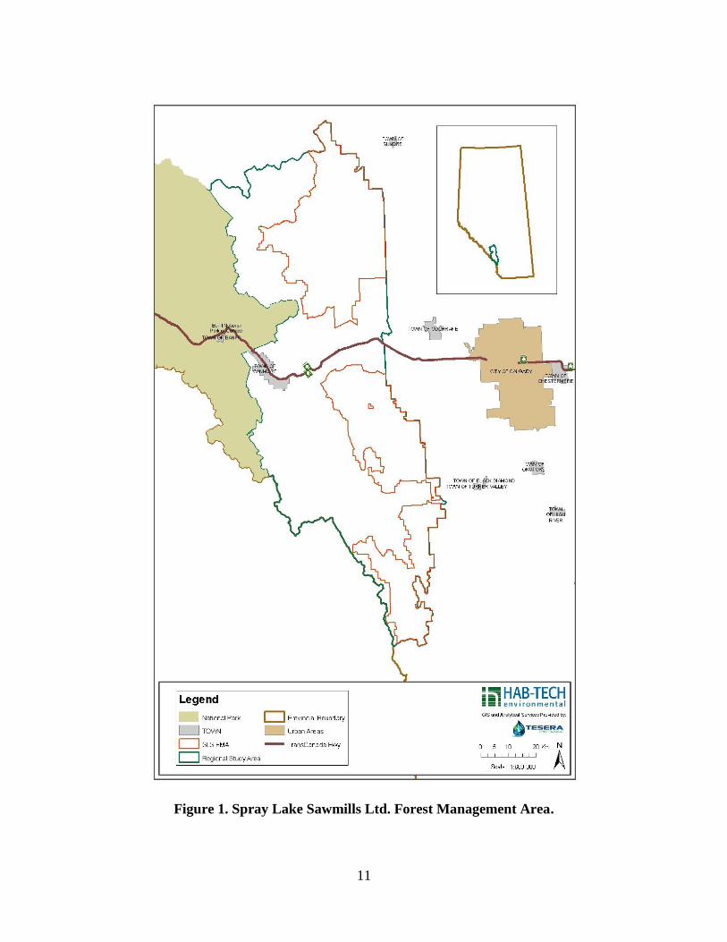
The SLS FMA and B9 Quota areas are based on administrative (as opposed to ecological)
boundaries as dictated by timber harvest management agreements. The FMA extends in a
narrow band from Sundre in the north to the southern end of Kananaskis Country. Total area of
the gross land base is 3,290 km2 of which a maximum of 2,285 km
2 is subject to timber harvest.
The assigned timber management areas are discontinuous from north to south with significant
breaks in the FMA along the Bow River (20-km) and Sheep River (10-km) valleys (Figure 1).
The boundaries of the FMA/B9 Quota intersect Alberta Natural Region and Subregions in a
somewhat 'haphazard' manner (Figure 2).
Dudley and Parish (2006) contend that ".....protected areas should never be regarded as separate
from the wider landscape"....and that "...protected areas should be integrated into wider
management systems, to ensure both the long-term survival of the biodiversity contained within
the protected area....". For the above reason and for the purpose of meeting size criteria for large
landscape-level forest criteria of the FSC Boreal Standard, SLS designated a larger regional area
for landscape-level gap analysis purposes. Figure 2 illustrates this region and its relationship
with the SLS FMA and Alberta Natural Regions and Subregions. This expanded regional
assessment area (RAA) is 7,831 km2 in size.
11
Figure 1. Spray Lake Sawmills Ltd. Forest Management Area.
12
Figure 2. SLS Regional Gap Analysis Area and Natural Subregions.

13
The eastern boundary of the RAA is delineated by the eastern extent of the SLS FMA and Rocky
Mountain Forest Reserve, beyond which fragmented agricultural lands occur. This boundary
also approximates the transition between the Rocky Mountain and Parkland Natural Regions in
the south FMA and between the Foothills and Boreal Mixedwood Natural Regions in the north
FMA. The northern boundary of the RAA is the transition between the Red Deer River and
North Saskatchewan River watersheds. The western boundary of the RAA is the eastern border
of Banff National Park and the Continental Divide between Alberta and British Columbia. The
southern boundary of the RAA is the divide between the Bow and Oldman River basins.
Natural Subregion representation in the RAA/FMA include (in descending order of land area):
Alpine (16.1%/0.63%) Subalpine (35.7%/31.6%), Montane (24.6%/27.62%), Upper Foothills
(14.4%/22.79%), and Lower Foothills (8.8%/17.32%). Negligible areas of Boreal Mixedwood
(<0.1%) and Foothills Parkland (0.4%) occur in the FMA but not in the RAA; these subregions
are not included as part of the gap analysis.
4.2 Step #2: Identification of Focal Biodiversity Indicators/Targets
Natural Subregions will serve as the key biodiversity indicator at the provincial (Alberta) and
regional (FMA region) scales, consistent with Alberta government and WWF methodology
(GAIA 1996; Iacobelli et al. 2006). Natural Subregions are used as a coarse-filter surrogate for
landscape, community and species-level biodiversity in the SLS FMA/B9 Quota area. Current
Provincial targets associated with this indicator are based on the Level 1 Natural History theme
targets at the provincial scale. The target selected for Natural Subregion protected area
representation in the SLS FMA is 12% of the provincial supply of subregions, recognizing
existing provincial protected areas and scaled to the relative proportion of the subregion
occurring in the FMA. The 12% target is consistent with targets set out by the IUCN and the
province of British Columbia. They are also the same as the original province of Alberta targets
under the Special Places 2000 program. Further details on biodiversity indicators and targets are
discussed in Sections 4.3 and 4.5.
4.3 Step #3: Evaluate and Map Biodiversity
Figure 2 shows the distribution of Natural Subregions in the FMA and RAA. The FMA lies
within the Front Ranges and foothills of the eastern slopes of the Rocky Mountains. Elevations
increase from east to west in the study region, with lowest elevations occurring in the Montane
and Lower Foothills subregions, intermediate elevations in the Upper Foothills subregion, and
highest elevations in the Subalpine and Alpine subregions. The representation of deciduous and
mixedwood forest cover types generally decline as elevations increase.
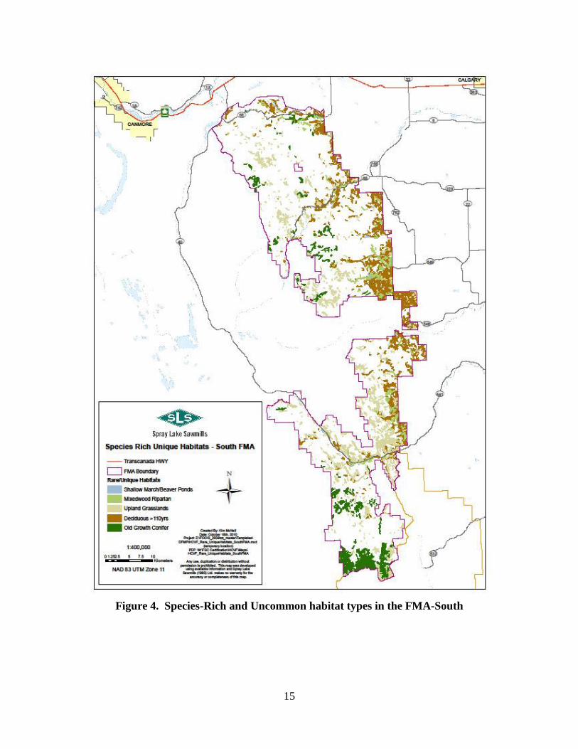
Plant species richness, vegetation structural diversity, landscape level diversity, and vertebrate
wildlife species richness are all highest in the lower elevation portions of the FMA (Collister and
Kansas 2003; SLS 2006; Kansas and Mogilefsky 2013), largely in association with mixedwood,
deciduous and riparian forests. Riparian mixedwood forest, shallow marsh wetlands, old growth
deciduous forests, upland grasslands, and old growth conifer forests were identified as
ecosystem-level, High Conservation Value Forest attributes because of their regional
uniqueness/rarity and their floristic, structural and vertebrate species at risk diversity (Kansas
and Mogilefsky 2013). The distribution of these habitat types are shown in the Figures 3 and 4.

14
Figure 3. Species-Rich and Uncommon habitat types in the FMA-North
15
Figure 4. Species-Rich and Uncommon habitat types in the FMA-South

16
A disproportionate amount of the uncommon and species-rich ecosystems occur in the lower
elevation Montane and Lower Foothills Natural subregions and along major river and creek
valleys (e.g. Highwood, Sheep, Elbow, Jumpingpound, Ghost and Red Deer). Ecologically
sensitive management and protection of lower elevation lands in the Montane and Lower
Foothills subregions near the eastern boundary of the FMA/B9 Quota are important to conserve
long-term biological diversity in the FMA (SLS 2006, Kansas and Mogilefsky 2013).
4.4 Step #4: Existing Occurrence/Status of Protected Areas
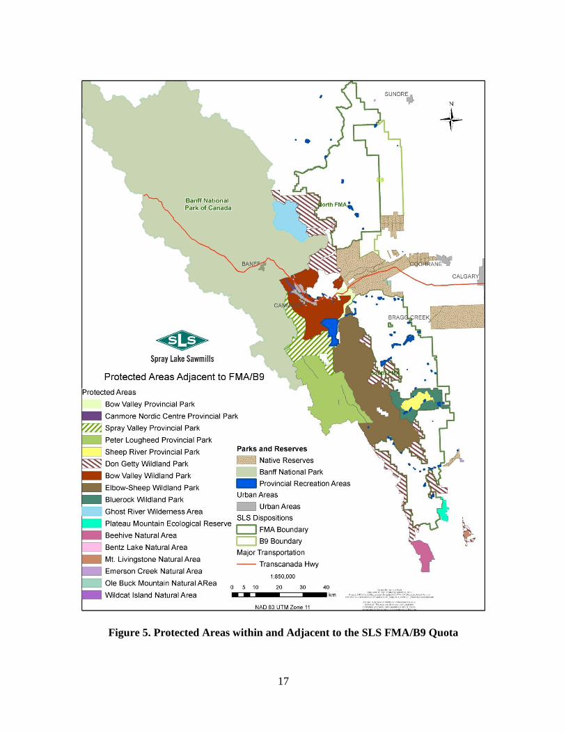
Figure 5 shows the distribution of currently protected areas within the regional vicinity of the
SLS FMA/B9 Quota. Approximately 37% of the RRA is comprised of formally protected areas,
including the Wildland Provincial Parks (WPP) and Provincial Parks (PP) (Don Getty WPP,
Elbow-Sheep WPP, Bluerock WPP, Sheep River PP). These areas occurs immediately adjacent
to and functionally within the FMA. The majority of formally protected land occurs at higher
elevations west of the FMA in a mosaic of Subalpine and Alpine subregional lands in the Elbow-
Sheep WPP and Don Getty WPP.
Approximately 329 km2 of protected lands also occur along the Sheep River and Bow River
valleys in what is now mapped as the Montane Natural Subregion. Industrial activity does not
occur in PPs or WPPs. Although backcountry recreation is common, these areas are wilderness
in nature and offer a level of protection commensurate with Level II of the IUCN classification
of protected areas management (IUCN 1994; Dudley and Parish 2006).
4.5 Step #5: Protected Area Gap Identification
This section of the report identifies current status and gaps in protected areas coverage in the
SLS FMA and RAA. Natural Subregion representation is used as a coarse-filter surrogate for
landscape, ecosystem and species level biodiversity (Section 4.3). Table 1 provides a summary
of the land area supply and protected area targets by Natural Subregion in the FMA and RAA.
The table identifies protected area gaps by Natural Subregion in the FMA; summarizes SLS's
historic protected area contributions; identifies the South Saskatchewan River Basin Candidate
Conservation Management Areas identified by the Resource Advisory Committee, and; outlines
the passive landbase available to meet specific ecological objectives and serve as permanent
reserves. The passive landbase is discussed in Section 4.6.4.
4.5.1 Rocky Mountain Natural Region
The Rocky Mountain Natural Region comprises three subregions based on elevation, topography
and vegetation characteristics. These include Montane, Subalpine and Alpine.
4.5.1.1 Montane Subregion
The Montane Subregion occupies 8,768 km2 (1.3%) of the province of Alberta. The Alberta
Tourism, Recreation and Parks department currently targets 620 km2 (7.1%) of the Montane's
four Level 1 Natural History themes for protection. This 7.1% target for Montane subregion
protection has been reached in the form of 26 parks and protected areas (Koch 2011).
17
Figure 5. Protected Areas within and Adjacent to the SLS FMA/B9 Quota
18
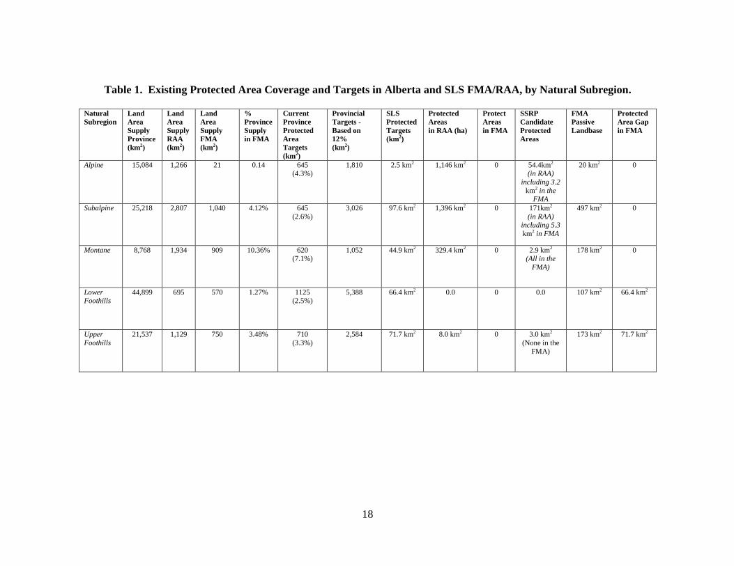
Table 1. Existing Protected Area Coverage and Targets in Alberta and SLS FMA/RAA, by Natural Subregion.
Natural
Subregion
Land
Area
Supply
Province
(km2)
Land
Area
Supply
RAA
(km2)
Land
Area
Supply
FMA
(km2)
%
Province
Supply
in FMA
Current
Province
Protected
Area
Targets
(km2)
Provincial
Targets -
Based on
12%
(km2)
SLS
Protected
Targets
(km2)
Protected
Areas
in RAA (ha)
Protect
Areas
in FMA
SSRP
Candidate
Protected
Areas
FMA
Passive
Landbase
Protected
Area Gap
in FMA
Alpine 15,084 1,266
21
0.14 645 (4.3%)
1,810
2.5 km2 1,146 km2 0 54.4km2
(in RAA)
including 3.2
km2 in the FMA
20 km2 0
Subalpine 25,218 2,807
1,040
4.12% 645
(2.6%)
3,026
97.6 km2 1,396 km2 0 171km2
(in RAA) including 5.3
km2 in FMA
497 km2 0
Montane 8,768 1,934
909
10.36% 620 (7.1%)
1,052
44.9 km2 329.4 km2 0 2.9 km2
(All in the
FMA)
178 km2 0
Lower Foothills
44,899 695
570
1.27% 1125
(2.5%)
5,388
66.4 km2 0.0 0 0.0 107 km2
66.4 km2
Upper
Foothills
21,537 1,129
750
3.48% 710
(3.3%)
2,584
71.7 km2 8.0 km2 0 3.0 km2
(None in the
FMA)
173 km2 71.7 km2
19
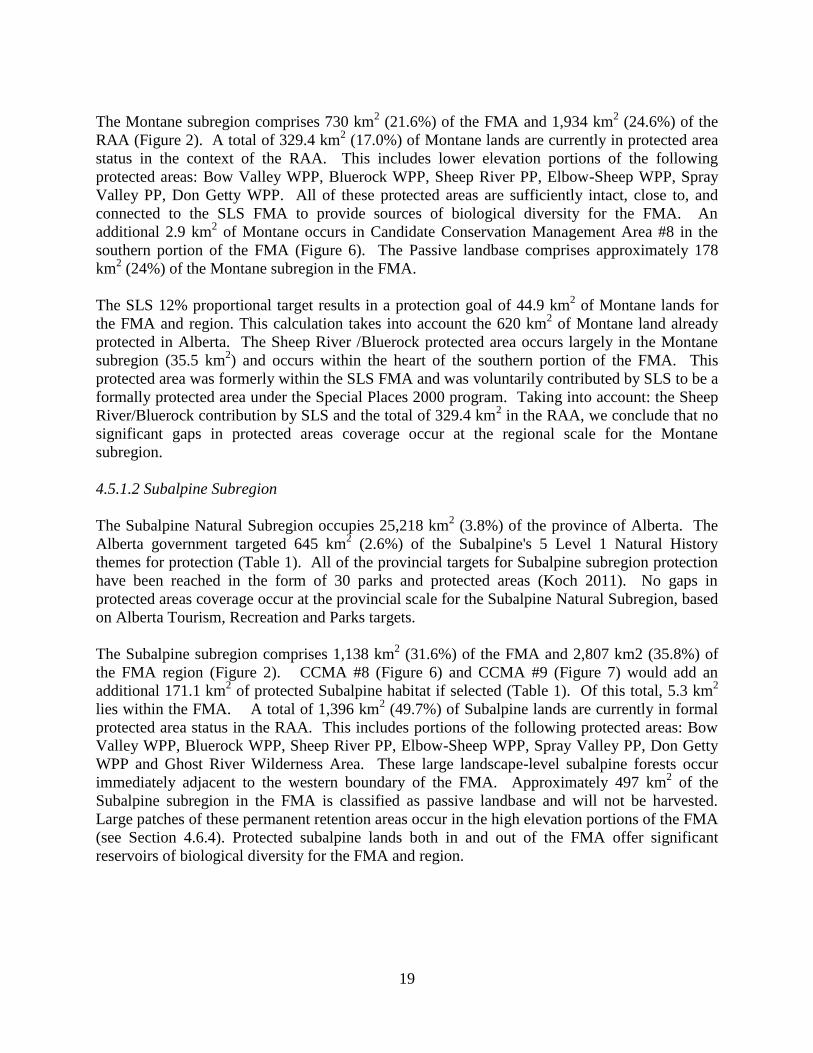
The Montane subregion comprises 730 km2 (21.6%) of the FMA and 1,934 km
2 (24.6%) of the
RAA (Figure 2). A total of 329.4 km2 (17.0%) of Montane lands are currently in protected area
status in the context of the RAA. This includes lower elevation portions of the following
protected areas: Bow Valley WPP, Bluerock WPP, Sheep River PP, Elbow-Sheep WPP, Spray
Valley PP, Don Getty WPP. All of these protected areas are sufficiently intact, close to, and
connected to the SLS FMA to provide sources of biological diversity for the FMA. An
additional 2.9 km2 of Montane occurs in Candidate Conservation Management Area #8 in the
southern portion of the FMA (Figure 6). The Passive landbase comprises approximately 178
km2 (24%) of the Montane subregion in the FMA.
The SLS 12% proportional target results in a protection goal of 44.9 km2 of Montane lands for
the FMA and region. This calculation takes into account the 620 km2 of Montane land already
protected in Alberta. The Sheep River /Bluerock protected area occurs largely in the Montane
subregion (35.5 km2) and occurs within the heart of the southern portion of the FMA. This
protected area was formerly within the SLS FMA and was voluntarily contributed by SLS to be a
formally protected area under the Special Places 2000 program. Taking into account: the Sheep
River/Bluerock contribution by SLS and the total of 329.4 km2 in the RAA, we conclude that no
significant gaps in protected areas coverage occur at the regional scale for the Montane
subregion.
4.5.1.2 Subalpine Subregion
The Subalpine Natural Subregion occupies 25,218 km2 (3.8%) of the province of Alberta. The
Alberta government targeted 645 km2 (2.6%) of the Subalpine's 5 Level 1 Natural History
themes for protection (Table 1). All of the provincial targets for Subalpine subregion protection
have been reached in the form of 30 parks and protected areas (Koch 2011). No gaps in
protected areas coverage occur at the provincial scale for the Subalpine Natural Subregion, based
on Alberta Tourism, Recreation and Parks targets.
The Subalpine subregion comprises 1,138 km2 (31.6%) of the FMA and 2,807 km2 (35.8%) of
the FMA region (Figure 2). CCMA #8 (Figure 6) and CCMA #9 (Figure 7) would add an
additional 171.1 km2 of protected Subalpine habitat if selected (Table 1). Of this total, 5.3 km
2
lies within the FMA. A total of 1,396 km2 (49.7%) of Subalpine lands are currently in formal
protected area status in the RAA. This includes portions of the following protected areas: Bow
Valley WPP, Bluerock WPP, Sheep River PP, Elbow-Sheep WPP, Spray Valley PP, Don Getty
WPP and Ghost River Wilderness Area. These large landscape-level subalpine forests occur
immediately adjacent to the western boundary of the FMA. Approximately 497 km2 of the
Subalpine subregion in the FMA is classified as passive landbase and will not be harvested.
Large patches of these permanent retention areas occur in the high elevation portions of the FMA
(see Section 4.6.4). Protected subalpine lands both in and out of the FMA offer significant
reservoirs of biological diversity for the FMA and region.

20
The SLS 12% proportional target results in a goal of 97.6 km2 of protected Subalpine for the
FMA. This calculation takes into account the 645 km2 of Subalpine land already protected in
Alberta. Based on the 49% protection of Subalpine lands in the region and the extensive patches
of passive landbase, we conclude that no significant gaps in protected areas coverage occur at the
regional scale for the Subalpine subregion.
4.5.1.3 Alpine Subregion
The Alpine Subregion occupies 15,084 km2 (2.3%) of the province of Alberta. The Alberta
government currently targets 645 km2 (4.3%) of the Alpine's 5 Level 1 Natural History themes
for protection. All of the provincial targets for Alpine subregion protection have been reached in
the form of 30 parks and protected areas (Koch 2011). No gaps in protected areas coverage
occur at the provincial scale for the Alpine subregion, based on Alberta Tourism, Recreation and
Parks targets. Alpine habitats are scarce in the FMA, occupying just 21 km2 (<1.0%). This
subregion does not support commercial timber harvest. Protected areas in the RAA cover 1,146
km2 or 90.5% of the Alpine subregion occurring in the FMA region. The SLS 12% proportional
target results in a goal of 2.5 km2 for the FMA and region. We conclude that no significant gaps
in protected areas coverage of Alpine lands occur at the regional scale.
4.5.2 Foothills Natural Region
The Foothills Natural Region occurs east and at lower elevations than the Rocky Mountain
Natural Region. This Region comprises two Subregions based on differences in elevation,
topography and vegetation. The Lower Foothills Natural Subregion occurs at lower elevations
and has warmer summers and colder winters than the Upper Foothills Natural Subregion. The
boundary between the Lower and Upper Foothills is characterised by a change in dominance
from mixedwood and deciduous forest stands on all aspects in the Lower Foothills Natural
Subregion to conifer-dominated forests in the Upper Foothills Natural Subregion (Natural
Regions Committee 2006).
4.5.2.1 Lower Foothills Subregion
The Lower Foothills Subregion occupies 44,899 km2 (6.8%) of the province of Alberta. The
Alberta government targets 1125 km2 (2.5%) of the Lower Foothills five Level 1 Natural History
themes in the Province for protection. Currently a total of 276.7 km2 (24.6%) of Lower Foothills
lands in the Province of Alberta is in protected status in the form of 12 parks and protected areas
(Koch 2011). The Lower Foothills subregion comprises 570 km2 (17.3%) of the FMA and 695
km2 (8.8%) of the FMA region (Figure 2). No formally protected areas occur within the Lower
Foothills subregion lands within the FMA and RAA, based on revised Natural
Regions/Subregions mapping (Natural Regions Committee 2006). Prior to these changes the
Sheep River Provincial Park and Bluerock Wildland Provincial Parks protected a combined 114
km2 of Lower Foothills habitat, respectively (see Section 3.2). A total of 107 km
2 of Lower
Foothills lands in the SLS FMA/B9 Quota area occur in the form of passive landbase (e.g.
riparian area, non-timber lands, steep slopes) and is protected from timber harvest.

21
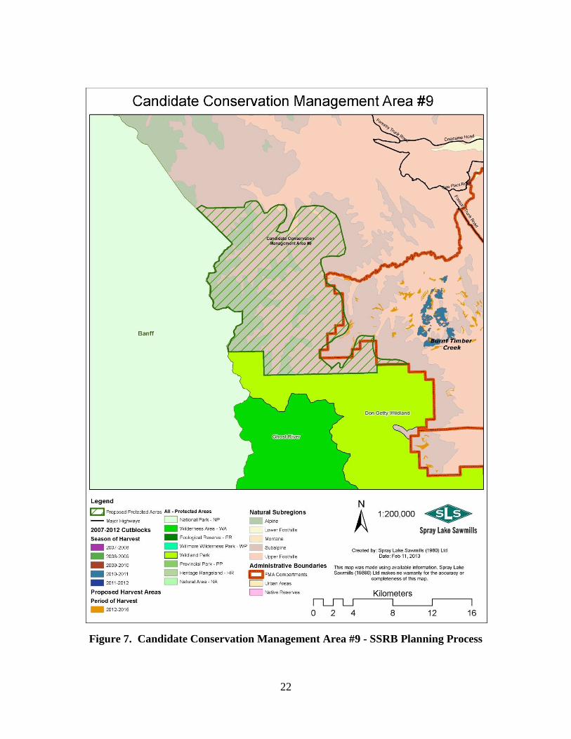
Figure 6. Candidate Conservation Management Area #8 - SSRB Planning Process
22
Figure 7. Candidate Conservation Management Area #9 - SSRB Planning Process
23
The SLS 12% proportional target results in a goal of 66.4 km2 of protected Lower Foothills lands
for the FMA. This calculation takes into account the 277 km2 of Lower Foothills land already
protected in Alberta. No lands are currently formally protected in the Lower Foothills Natural
Subregion in the FMA or RAA resulting in a significant gap in the formal protection of Lower
Foothills lands in the FMA. This does not include portions of the 107 km2 of the Lower
Foothills passive landbase, potentially available to contribute to a protected area network beyond
the management unit.
4.5.2.2 Upper Foothills Subregion
The Upper Foothills Subregion occupies 21,537 km2 (3.3%) of the province of Alberta. The
Alberta government targets 710 km2 (3.3%) of the Upper Foothills five Level 1 Natural History
themes in the province for protection. Currently, a total of 551.4 km2 (2.6%) of Upper Foothills
lands in the Province of Alberta is in protected status in the form of 19 parks and protected areas
(Koch 2011).
The Upper Foothills Natural Subregion comprises 750 km2 (22.7%) of the FMA and 1,129 km
2
(14.4%) of the FMA region (Figure 2). A total of 8.0 km2 of Upper Foothills lands are currently
protected in the RAA immediately adjacent to but outside of the FMA (Koch 2011). This is an
area east of the Ghost River Wilderness area in Don Getty WPP (Figure 5). If selected,
Candidate Conservation Management Area #9 (Figure 7) from the South Saskatchewan River
basin planning process would add another 3.0 km2of protected Upper Foothills land. A total of
173 km2 of Upper Foothills lands the SLS FMA/B9 Quota area is in the form of passive landbase
and is protected from timber harvest.
The SLS 12% proportional target results in a goal of 71.7 km2
of protected Upper Foothills lands
for the FMA. This calculation takes into account the 551 km2 of Upper Foothills land already
protected in Alberta. No lands are currently formally protected in the Upper Foothills Natural
Subregion in the FMA, and only 8 km2 are protected in the RAA. We conclude that gaps remain
in the formal protection of Upper Foothills lands in the FMA and RAA. This does not include
portions of the 173 km2 of the Upper Foothills passive landbase, potentially available to
contribute to a protected area network beyond the management unit.
4.6 Step #6: Gap Prioritization
Section 4.5 identified that protected areas representation gaps occur in the Upper and Lower
Foothills Natural Subregions at both provincial and regional scales. Protected areas gaps for
these two subregions also occur in the FMA. The High Conservation Forest Assessment (Kansas
and Mogilefsky 2013) and Section 3.3 of this report identified lower elevation lands, including
those in the Lower Foothills and Montane subregions, as biodiversity 'hotspots'. Upper Foothills
lands do not tend to be as diverse as Lower Foothills and Montane lands because of the relative
scarcity of deciduous and mixedwood forests, riparian forests, and marsh wetlands (Natural
Regions Committee 2006). From a biodiversity richness perspective, Upper Foothill habitats are
more similar to Subalpine habitats than they are to the Lower Foothills or Montane.
24
4.6.1 Special Case of the Sheep River/Bluerock Protected Areas
In Section 3.2, the origins of the Sheep River Provincial Park and adjacent Bluerock Wildland
Provincial Park were described. These protected areas were established to assist in fulfilling
Foothills Natural Region protected area targets, since at the time these two parks were classified
almost entirely as being within the Lower Foothills Natural Subregion. As recognized by GAIA,
(1996) this area is a hot-spot of ecological diversity, because of the occurrence of lower elevation
deciduous, mixedwood and riparian forest cover types (Collister and Kansas 2003). Figure 8
illustrates the disproportionate abundance of high suitability habitat for multiple focal vertebrate
wildlife species in the area, in the context of the remainder of the southern portion of the FMA.
No other portion of the SLS FMA region offers an equivalent combination of ecological
diversity, lack of industrial development, and limits to motorized vehicles as does the
Sheep/Bluerock protected area. The Conservation Biology Institute (2007) singled out the Sheep
River Provincial Park/Bluerock Wildland Park block as being one of only two protected areas
larger than 10,000 ha in the Foothills of Alberta and northeast British Columbia. The other was
Bearhole Lake Provincial Park (~18,000 ha) which occurs in the province of British Columbia.
Regardless of whether the Sheep River/Bluerock protected areas are classified as Lower
Foothills or Montane, this area is a vital reservoir of lower elevation vegetation and wildlife
diversity in the heart of the former SLS FMA. This protected area connects two large chunks of
Spray Lake's FMA as well as higher elevation Subalpine and Alpine protected lands of the
Elbow-Sheep Wildland Provincial Park to the west.
Prior to the changes in Natural Region and Subregion classification (Natural Regions Committee
2006), the voluntary removal of these areas from the SLS FMA and conversion to protected
areas would have resulted in an additional 114 km2 of Lower Foothills protected land exceeding
SLS’s self-imposed 12% target. This level of contribution would have represented
approximately 20% of the total Lower Foothills FMA subregion in formal protection status.
Based on current classification of these lands, the designation of Sheep River/Bluerock as a
protected area adds to a regional and provincial surplus of Montane protected lands.
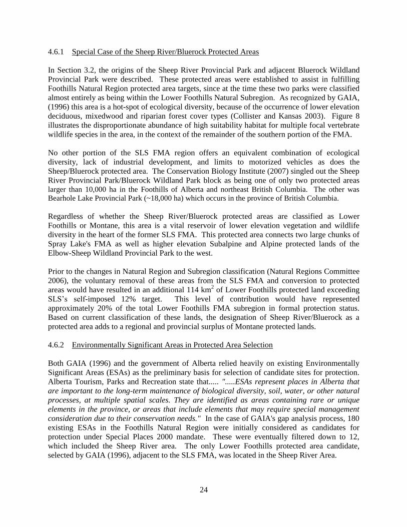
4.6.2 Environmentally Significant Areas in Protected Area Selection
Both GAIA (1996) and the government of Alberta relied heavily on existing Environmentally
Significant Areas (ESAs) as the preliminary basis for selection of candidate sites for protection.
Alberta Tourism, Parks and Recreation state that..... ".....ESAs represent places in Alberta that
are important to the long-term maintenance of biological diversity, soil, water, or other natural
processes, at multiple spatial scales. They are identified as areas containing rare or unique
elements in the province, or areas that include elements that may require special management
consideration due to their conservation needs." In the case of GAIA's gap analysis process, 180
existing ESAs in the Foothills Natural Region were initially considered as candidates for
protection under Special Places 2000 mandate. These were eventually filtered down to 12,
which included the Sheep River area. The only Lower Foothills protected area candidate,
selected by GAIA (1996), adjacent to the SLS FMA, was located in the Sheep River Area.

25
Figure 8. Multi-species Habitat Ratings in the Sheep River/Bluerock areas and region.

26
GAIA (1996) noted that all short-listed candidates were..."....by and large....the least developed"
and that, in Alberta, ESAs are used as planning tools for conservation and protected areas
designation. GAIA (1996) further stated that.... "the results of this report underscore the
difficulty in developing an adequate protected areas network for the Foothills Natural Region
primarily because of the extent to which the land base is already fragmented by various resource
and recreational activities. No pristine or wilderness areas remain that have not suffered some
loss of their original ecological integrity". The Conservation Biology Institute (2007) echoed
GAIA's comments stating.... "It is difficult to predict how much of the ecoregion could be placed
into new protected areas via the existing political process. With over 86 percent of the ecoregion
already allocated in logging tenures and with oil and gas development widespread, it is going to be
difficult to establish many new protected areas even though the science strongly argues for much
more land placed under protection status."
According to changes in Alberta Natural Regions mapping (Natural Regions Committee 2006),
both Lower and Upper Foothills Subregions occur only in the northern portion of the SLS FMA
north of the Bow River (Figure 2). It is noteworthy, that neither the GAIA (1996) gap analysis
nor the recent SSRB gap analysis selected either Lower or Upper Foothills habitats in the SLS
FMA north of the Bow River (as currently mapped) as protected area candidates or CCMAs.
This is likely because of the presence of widely scattered private lands (in B9), the levels of
multiple land use, and relative shortage of ESAs in this area (Figure 9).
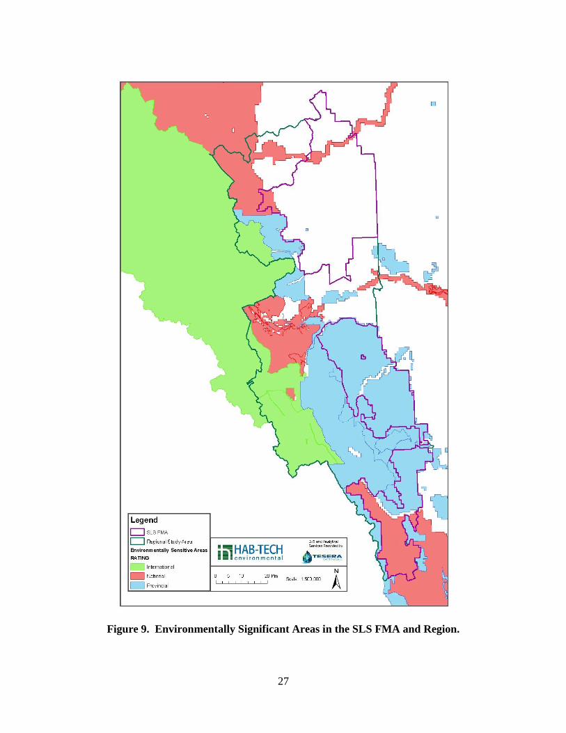
4.6.3 Red Deer River ESA #20
A single, nationally ranked Environmentally Significant Area occurs in and adjacent to the
northern portion of the FMA, with its eastern extent - the Red Deer River valley - traversing both
Lower and Upper Foothills lands in the FMA (Figure 9). ESA (#20) is very large (9,438 km2)
and extends north to the Brazeau/Cardinal River confluence area. The Red Deer River portion of
this ESA transects the FMA from east to west. The portion of ESA #20 in the FMA is comprised
of 22.4 km2 of Lower Foothills and 6.9 km
2 of Upper Foothills lands. The HCVF report for SLS,
selected the Red Deer River valley portion of ESA #20 as a High Conservation Value Forest
attribute because it represents a natural east-west movement corridor for numerous species of
wildlife, as well as a wintering area for ungulate populations and spawning habitat for a number
of fish species (Kansas and Mogilefsky 2013). Figure 3 shows the disproportionate amount of
species rich and uncommon habitat types along the Red Deer River corridor including riparian
mixedwood forests and old growth deciduous forests. A close up of the distribution of Natural
Regions and unique habitat types occurring in the portion of the Red Deer ESA #20 that transects
the SLS FMA is shown in Figure 10.
The Conservation Biology Institute (2007) report stressed the importance of main river corridors
in the Foothills region as potential protected or special management areas. They noted that .....
"Functionally connecting existing and new protected areas is an important consideration in this
ecoregion and the main river segments highlighted offer an important opportunity to do that both
from the standpoint of aquatic and terrestrial conservation values."
27
Figure 9. Environmentally Significant Areas in the SLS FMA and Region.
28
Figure 10. Unique and biodiversity rich habitat types in Red Deer ESA (#20).

29
Bentz and Karpuk (1990) and Sweetgrass Consultants (1997) noted that the Upper Red Deer
River ESA was one of the most diverse river valleys in the Foothills of Alberta and that it offered
the following important ecological benefits:
key winter ungulate habitat and travel corridor;
high wildlife species diversity;
sport fishery (including Bull Trout, Brook Trout and Mountain Whitefish);
important migration corridor for Mountain Whitefish;
diverse shrubland and riparian plant communities;
important recreational watercourse; and,
Critical Wildlife Zone.
We conclude that portions of the Red Deer River ESA #20 and immediate environs offer strong
potential to serve as a formally protected area candidate in the FMA, primarily to fill a portion of
the gaps identified in the biologically diverse Lower Foothills subregion.
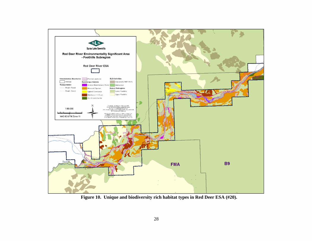
4.6.4 Protection Role of the Passive Landbase
Approximately 28.8% of the SLS FMA is not subject to timber harvest now or into the future
(SLS 2006). These areas, which contain permanent retention of vegetation, are referred to as
passive landbase. The portions of the passive landbase containing natural habitat (i.e. not
industrial sites, roads, or pipelines etc.) occur primarily in the following situations:
on steep slopes;
within riparian/wetland buffers (hydrological protection);
'unproductive stands' from a harvest perspective;
non-forested lands;
protected areas; and,
isolated and non-accessible stands.
The areas set aside as passive landbase encompass a wide range of habitat types, including each
of the five unique and biodiversity rich habitat types identified as HCVF (i.e. shallow
marsh/beaver ponds, upland grassland, riparian mixedwood forest, old growth conifer forest and
deciduous forest >100 years). Figures 11 and 12 illustrate the distribution and size of patches of
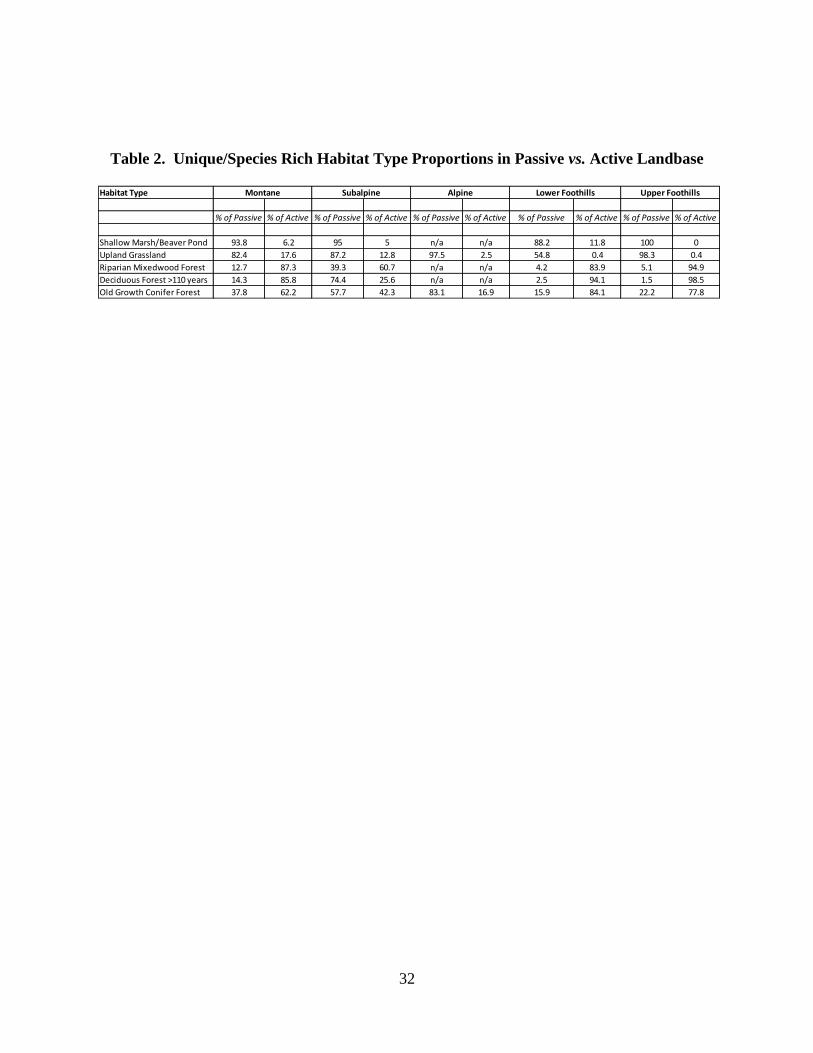
passive landbase in the north and south portions of the SLS FMA, respectively. Table 2
summarizes land areas for the 5 unique habitat types within the passive versus active (planned
harvest) landbases in the SLS FMA. This summary shows that shallow marsh, upland grassland
and high elevation forests comprise a higher proportion of the passive versus active landbase.
Patch sizes of the passive landbase are highly variable and some habitat patches (i.e. particularly
old growth conifer in the Subalpine) are relatively large in the context of the active landbase.
Through design and inclusion of active landbase, patch sizes can be greatly increased to provide
an ecologically important network beyond the management unit.

30
Figure 11. Passive Landbase and Unique, Species-Rich Habitats in the North FMA.
31
Figure 12. Passive Landbase and Unique, Species-Rich Habitats in the South FMA.
32
Table 2. Unique/Species Rich Habitat Type Proportions in Passive vs. Active Landbase
Habitat Type
% of Passive % of Active % of Passive % of Active % of Passive % of Active % of Passive % of Active % of Passive % of Active
Shallow Marsh/Beaver Pond 93.8 6.2 95 5 n/a n/a 88.2 11.8 100 0
Upland Grassland 82.4 17.6 87.2 12.8 97.5 2.5 54.8 0.4 98.3 0.4
Riparian Mixedwood Forest 12.7 87.3 39.3 60.7 n/a n/a 4.2 83.9 5.1 94.9
Deciduous Forest >110 years 14.3 85.8 74.4 25.6 n/a n/a 2.5 94.1 1.5 98.5
Old Growth Conifer Forest 37.8 62.2 57.7 42.3 83.1 16.9 15.9 84.1 22.2 77.8
Montane Subalpine Alpine Upper FoothillsLower Foothills

33
4.7 Step 7: SLS Strategy for Filling Protected Area Gaps in FMA
Protected areas within the Foothills Natural Region are under-represented in the SLS FMA and
regional environs. SLS will utilize three potential sources to fill protected areas gaps: 1) The
Red Deer River ESA for formal protection. The Red Deer River portion of nationally significant
ESA #20 occurs in the northern portion of the FMA and crosses mainly Lower Foothills lands,
with some Upper Foothills. This ESA (or portions thereof) offers strong potential as a protected
areas candidate for Foothills habitats in the FMA. SLS will collaborate with interested parties
and stakeholders through the formal protection process, outlined in this paper; 2) The passive
landbase areas, designed to meet specific ecological objectives and serve as permanent reserves.
Portions of the passive and active landbase will be designed with stakeholders to contribute to a
protected area network beyond the management unit; and, 3) SSRP CCMA’s having ecological
integrity serving as protected areas. (pending final SSRP regional plan land use designations).
The SSRP is a government led process and the draft plan is due for public release, the fall of
2013. SLS has elected to use a 12% protected areas target for prioritizing gaps. Targets for
protection inside of the FMA are 66.4 km2 for Lower Foothills and 71.7 km
2 for Upper
Foothills. These targets are based on outstanding deficits in Provincial Foothills subregion
targets (based on 12% protection) and SLS's proportionate share of provincial land area supply
of these two Subregions.
The following outlines SLS’s defined process for meeting Foothills protection targets set by SLS
in the FMA. Note, that steps 2-4 are designed for candidates to be moved toward formal
protection.
4.7.1 Step 1: Site Identification and Selection
SLS has identified the following sources to fill gaps and serve as the protected areas network: 1)
The Red Deer River ESA; and, 2) passive landbase areas designed to meet specific ecological
objectives and serve as permanent reserves. SLS will work with interested parties to assess the
Foothills subregion passive landbase for ecological integrity and collaborate with interested
parties on an ongoing basis. Portions of the passive and active landbase will be designed with
stakeholders to contribute to a protected area network beyond the management unit (similar to
how the FSC quantifies protected area contributions in British Columbia). This process of
collaboration will be open to First Nations, government, commercial interests, disposition
holders, ENGO stakeholders and the public. 3) SLS will recognize SSRP, CCMA’s having
ecological integrity in the Foothills subregion, serving as formal or informal protected areas. The
SSRP is a government led process and the draft plan is due for public release, the fall of 2013.
4.7.2 Step 2: Feasibility Assessment
The second step is to conduct a series of feasibility assessments. These will include an
ecosystem assessment and a strategic environmental assessment, to evaluate the environmental
condition of the candidate sites and the impact that the potential new protected area could have
socially and environmentally. In addition, First Nations, government, commercial interests,
disposition holders, NGO stakeholders and public consultations will be conducted to determine
the feasibility of turning a candidate site into a formal or protected area reserve beyond the
management unit. The results of these ecological, social and economic assessments will help to

34
determine the boundaries and the various options available for protection, in accordance with the
land use zoning, disposition, ownership and jurisdiction of the land area targeted.
4.7.3 Step 3: Securement & Agreement
Once a candidate site(s) is selected for formal protection, the type of protected area will
determine the instruments available for securing the lands.
4.7.4 Step 4: Regulatory Process
SLS will commit to deferred timber harvesting and nominate site(s) to help meet Protected Area
gaps in the Upper and Lower Foothills Natural Subregions. For candidate(s) to be nominated for
formal protection, the provincial government will then lead this process. In Alberta, protected
areas are legally designated in two ways.
Provincial parks, wildland provincial parks, heritage rangelands, provincial recreation
areas, natural areas and ecological reserves are established by order-in-council, under
their respective Acts. Orders-in-council are issued by the Lieutenant Governor-in-
Council.
Wilderness protected areas such as White Goat, Ghost River and Siffleur wilderness
areas and Willmore Wilderness Park were established in legislation. Their boundaries
are described in "schedules" under their respective Acts.
35
5.0 SUMMARY AND CONCLUSIONS
5.1 Protected Area Gap Analysis Summary
The purpose of this gap analysis was to assess the comprehensiveness of the existing
protected area network in the Spray Lake Sawmills (SLS) FMA/B9 Quota and region and
to identify and prioritize underrepresented elements of biological diversity.
Two previous representation gap analyses were conducted in the area: 1) for the Foothills
Natural Region at a provincial scale in the mid-1990s; and, 2) on-going for the South
Saskatchewan River Basin planning area at a watershed/regional scale. These gap
analyses resulted in the selection of several existing or candidate protected areas in and
immediately adjacent to the FMA. SLS officials were actively involved with both of the
previous gap analyses/planning processes.
The current gap analysis conducted for the SLS FMA/B9 Quota follows standard
scientific approaches used by the Secretariat for the Convention on Biological Diversity
(CBD) and World Wildlife Fund.
The gap analysis considers both the SLS FMA/B9 Quota and a broader region of
contiguous Natural Subregions surrounding the FMA. This is consistent with methods
used for the HCVF and by the Secretariat for the Convention on Biological Diversity.
Natural Subregions were used as a coarse-filter surrogate for landscape, community and
species-level biodiversity in the SLS FMA/B9 Quota area.
The FMA region comprises portions of the five Natural Subregions (from lower to higher
elevation) - Lower Foothills, Upper Foothills and Montane, Subalpine and Alpine.
Lower elevation lands in the Montane and Lower Foothills subregions support
disproportionately higher levels of vegetation composition, structure (vertical and
horizontal) and vertebrate wildlife diversity than do the Upper Foothills, Subalpine and
Alpine natural regions.
Approximately 37% of the RAA, is formally protected including: the Wildland Provincial
Parks (WPP) and Provincial Parks (PP) comprised of the Don Getty WPP, Elbow-Sheep
WPP, Bluerock WPP, and Sheep River PP, which occur immediately adjacent to and
functionally within the FMA. Approximately, 28% of the FMA is designated as passive
landbase, and is not planned for timber harvest. These areas are extensive, and offer
significant sources of gap-filling potential as permanent reserves beyond the management
unit.
36
Upper elevation Subalpine and Alpine Subregion lands are significantly protected in the
Province of Alberta, meeting Level 1 protected area targets used by Alberta Tourism,
Parks and Recreation. Almost 50% of the Subalpine Subregion lands are protected in the
FMA region, and an additional 8.5 km2 of mixed Subalpine/Alpine lands in the SLS
FMA are candidates for protection as part of the soon to be released South Saskatchewan
River plan.
The Montane Natural Subregion is well protected in the Province of Alberta, meeting
Level 1 protected area targets used by Alberta Tourism, Parks and Recreation. A total of
329.4 km2 (17.0%) of Montane lands are currently in protected area status in the FMA
region. This includes lower elevation portions of the following protected areas: Bow
Valley WPP, Bluerock WPP, Sheep River PP, Elbow-Sheep WPP, Spray Valley PP, Don
Getty WPP. An additional 3 km2 of Montane is being considered as a candidate for
protection in the FMA as part of the South Saskatchewan River Basin planning
framework.
Currently, a total of 551.4 km2 (2.6%) of Upper Foothills lands in the Province of
Alberta is in protected status in the form of 19 parks and protected areas (Koch 2011).
Approximately 71.7 km2 of lands remain to be protected in the Upper Foothills to meet
SLS’s proportionate 12% target. The Don Getty Wildland Provincial Park protects 8 km2
of Upper Foothills lands in the northern portion of the FMA region, immediately west of
the FMA boundary. Another 3 km2 of Upper Foothills land is a potential source for
protection as candidate conservation management areas as part of the SSRB planning
process.
Approximately one-quarter (24.6%) of the Level 1 targets have been reached for Lower
Foothills protection in the province, based on Alberta Tourism, Recreation and Parks
information. Approximately 848 km2 of lands remain to be protected in the Lower
Foothills in order to meet provincial targets. SLS has adopted a proportionate share of
12% for the Lower Foothills target and has identified a gap of 66.4 km2 for the FMA.
5.2 Protected Area Gap Analysis Conclusions
The SLS FMA region currently contains an overall high proportion of protected areas.
Approximately 37% of the RAA is comprised of formally protected areas, including the
Wildland Provincial Parks (WPP) and Provincial Parks (PP) (Don Getty WPP, Elbow-
Sheep WPP, Bluerock WPP, Sheep River PP), which occur immediately adjacent to and
functionally within the FMA. Additional Subalpine, and Alpine lands have potential to
be added within the FMA (8.8 km2) and immediately adjacent (217 km
2) the FMA, as
part of the SSRB planning process.

37
The existing protected areas in the Subalpine and Alpine zones of the FMA and region
are sufficient to protect biological diversity at a landscape level. No further protected
areas are recommended in these two Natural Subregions, other than the 8.5 km2 of land
being considered for protection as part of the SSRB planning process.
The Montane Natural Subregion is well represented (17.0%) by protected areas in the
SLS FMA region, including the Sheep River Provincial Park/Bluerock Wildland
Provincial Park block. No further protected areas are recommended for this subregion, in
the FMA, other than the 3 km2 of land being considered for protection as part of the
SSRB planning process.
Protected areas within the Foothills Natural Region are under-represented in the SLS
FMA and regional environs. The Lower Foothills subregion is more biologically diverse
than the Upper Foothills and as such is of higher priority for protection.
The Alberta government targets of 2.5% and 3.3% for province-wide Lower and Upper
Foothills protection are significantly lower than current standards for protected areas
identified in the literature. SLS has adopted a 12% protection level proportionate to the
occurrence of these two subregions in the FMA.
Based on SLS’s 12% proportional protection target, SLS and stakeholders will identify
approximately 71.7km2 and 66.4 km
2 of protection in the Upper and Lower Foothills
subregions respectively in the FMA region.
SLS will utilize three potential sources to fill protected areas gaps: 1) The Red Deer
River ESA for formal protection. The Red Deer River portion of nationally significant
ESA #20 occurs in the northern portion of the FMA and crosses mainly Lower Foothills
lands, with some Upper Foothills. This ESA (or portions thereof) offers strong potential
as a protected areas candidate for Foothills habitats in the FMA. SLS will collaborate
with interested parties and stakeholders through the formal protection process, outlined in
this paper; 2) The passive landbase areas designed to meet specific ecological objectives
and serve as permanent reserves. Portions of the passive and active landbase will be
designed with stakeholders to contribute to a protected area network beyond the
management unit; and, 3) The SSRP CCMA’s having ecological integrity, serving as
formal or informal protected areas. The SSRP is a government led process due for public
release, in the fall of 2013.
38
6.0 LITERATURE CITED
Balmford, A, N. Leader-Williams, and J.B. Green. 1995. Parks or arks: Where to conserve large
threatened mammals. Biodiversity and Conservation 4: 595–607.
Bentz, J. and E. Karpuk. 1990. Biophysical inventory and land use evaluations of the Upper Red
Deer River corridor. Alberta Forestry, Lands and Wildlife, Land Information Services Division.
50 pp
Bruner A.G, Gullison R.E, Rice R.E, Fonseca G.A.B. Effectiveness of parks in protecting
tropical biodiversity. Science. 2001;291:125–128.
Collister, D.M. and J.L. Kansas. 2003. B10 FMU Terrestrial Ecosystem Management project.
Final report. Prep. for Spray Lake Sawmills (1980) Ltd. by URSUS Ecosystem Management Ltd.
Calgary, AB. 117 pp.
Convention on Biological Diversity (CBD). 1992. Preamble to the Convention on Biological
Diversity.
Conservation Biology Institute 2007. Mapping High Conservation Value Forests in the Alberta
Foothills using spatially explicit decision support tools. Prepared for Limited Brands. 66 pp.
Davis, F.W., P.E. Stine, D.M. Stoms, M.I. Borchert, and A.D. Hollander. 1995. Gap analysis of
the actual vegetation of California 1. The southwestern region. Manrono 42:40-78.
Dudley, N. and J. Parish (2006).Closing the Gap. Creating Ecologically Representative Protected
Area Systems: A Guide to Conducting the Gap Assessments of Protected Area Systems for the
Convention on Biological Diversity. Secretariat of the Convention on Biological Diversity,
Montreal, Technical Series no. 24, vi + 108 pages
Flather, C.H., K.R. Wilson, D.J. Dean, and W.C. McComb. 1997. Identifying gaps in
conservation networks: Of indicators and uncertainty in geographic-based analysis. Ecological
Applications 7(2):531-542.
Forest Stewardship Council (FSC) Canada. 2004. National Boreal Standard. Version 3.0. January
16, 2004. 176 pp.
GAIA Consultants Inc. (GAIA). 1996. Assessment of the Foothills Natural Region protected
areas network. Prep. for World Wildlife Fund Canada. 33 pp.
Iacobelli, A., H. Alidina, A. Blasutti, C. Anderson, and K. Kavanagh. 2006. A landscape-based
protected areas gap analysis and GIS tool for conservation planning. World Wildlife Fund. 134
pp.
Jennings, M.D. 2000. Gap analysis: concepts, methods, and recent results. Landscape Ecology
15: 5 -20.

39
Kansas, J.L. and J. Mogilefsky. 2013. High conservation value forest assessment - Spray lake
Sawmills (1980) Ltd. Forest Management Agreement and B9 Quota area. Prep. for Spray Lake
Sawmills (1980) Ltd. 131 pp.
Kavanagh, K. and T. Iacobelli. 1995. A protected areas gap analysis methodology: Planning for
the conservation of biodiversity. World Wildlife Fund. 68 pp.
Koch, J. 2011. A review of Alberta's Protected Areas Gap Analysis and the Spray Lake
Sawmills (1980) Ltd. Forest Management Agreement and B9 Quota area. Prep. for Spray Lake
Sawmills (1980) Ltd. 32 pp.
Lawton, J.H. and R.M. May. 1995. Extinction rates. Oxford University Press, Oxford. 233 pp.
Lowry, J. et al. 2007. Mapping moderate-scale land cover over very large geographic areas
within a collaborative framework: A case study of the Southwest Regional Gap Analysis Project
(SWReGAP). Remote Sensing of Environment 108:59-73.
Higgins, J.V., Ricketts, T.H., Parrish, J.D., Dinerstein, E., Powell, G., Palminteri, S., Hoekstra,
J.M., Morrison, J., Tomasek, A. and Adams, J. 2004. Beyond Noah: saving species is not
enough. Conservation Biology 18: 1672–1673.
Margules, C.R. and R.L. Pressey. 2000. Systematic conservation planning. Nature 45:243-253.
Natural Regions Committee 2006. Natural Regions and Subregions of Alberta. Compiled by D.J.
Downing and W.W. Pettapiece. Government of Alberta. Pub. No. T/852.
Rainforest Alliance - Smartwood 2012. Forest management certification assessment report for:
Spray Lake Sawmills (1980) Ltd. in Cochrane, Alberta, Canada. Rainforest Alliance Smartwood
Program. 295 pp.
Rodrigues, A.S.L. et al. 2004. Global gap analysis: Priority regions for expanding the global
protected-area network. BioScience 54(12):1092-1100.
Scott, J.M., B. Csuti, J.D. Jacobi, and J.E. Estes. 1987. Species richness: a geographical
approach to protecting biodiversity. Bioscience 37:782-788.
Soule, M.E. 1991. Conservation: Tactics for a constant crisis. Science, 253: 744-750.
Spray Lake Sawmills (SLS). 2006. Detailed Forest Management Plan – 2001 to 2026. Prep. for
the Alberta Government, Edmonton, Alberta.
Stoms, D.M., F.W. Davis, K.L. Driese, K.M. Cassidy, and M.P. Murray. 1998. Gap analysis of
the vegetation of the Intermountain Semi-Desert Ecoregion. Great Basin Naturalist 58:199-216.

40
Sweetgrass Consultants Ltd. 1997. Environmentally Significant Areas of Alberta. Volume 2.
Prepared by Sweetgrass Consultants Ltd. for Resource Data Division, Alberta Environmental
Protection, Edmonton, Alberta. 580 pp.
IUCN—The World Conservation Union. IUCN; Gland, Switzerland: 1994. Guidelines for
protected area management categories.